Flood Areas (Edition 2019) - Senatsverwaltung für ...
←
→
Page content transcription
If your browser does not render page correctly, please read the page content below
02.21 Flood Areas (Edition 2019)
Overview
Exceptionally heavy or prolonged rainfall and snowmelt may lead to flooding. Floods are natural
phenomena that cannot be prevented. The adverse effects of floods are aggravated both by the
growing number of settlement areas and property assets in risk areas as well as the decreased natural
water retention capacity of landscape and soil caused by intensified land use.
Floods in Berlin are caused by heavy or persistant rain, for example. Flood waves differ, depending on
the nature of the rain. Heavy rain following storm fronts can often be observed during the summer
months. It is characterized by the highest rainfall intensities, regionally contained and relatively short in
duration. Heavy rain is the main cause of rapidly rising flood waves, e.g. at river Panke. Such floods
form a lot faster due to the city’s high degree of impervious soil coverage (cf. Environmental Atlas
01.02). Prolonged rain in larger catchment areas is the main cause of flooding at the Erpe
(Neuenhagener Mühlenfließ), Tegeler Fließ and the rivers Spree and Havel. Such flood waves are
much shallower but last longer in the waters affected.
No flood protection is perfect. Flood damage may only be reduced or prevented in the long run,
however, if a comprehensive system to manage flood risks is in place. The management of flood
risks is a communal project for society. It comprises various aspects such as prevention, protection,
precaution and restoration / regeneration. The key to keeping flood damage at bay lies in the
combination of state prevention and proactive individual citizens. Any person who may be affected by
flooding is obliged, within the limits of the person’s possibilities and reason, to take appropriate
preventive measures in order to protect against adverse effects of flooding and to mitigate further
damage, in particular to adapt the land use to the possible adverse flood effects for humans, the
environment or material assets (Section 5 (2) of the Federal Water Act (Wasserhaushaltsgesetz,
WHG)). Measures included in the flood risk management plan are conducive to superior flood control,
and, beyond that, they contribute to improved flood precautions and flood risk prevention at river Elbe
(FRM Plan, 2015).
Identifying flood areas is part of flood prevention and flood control. The Federal Water Act (WHG)
stipulates that at least those areas must be defined by ordinance, which are statistically expected to be
flooded at least once every 100 years (cf. Section 76 WHG). Defining flood areas serves the protection
against the dangers of floods, i.e. by
1. preserving natural retention areas,
2. controlling flood discharge,
3. reducing existing and avoiding new damage potential, and,
4. flood-adapted handling of substances hazardous to water.
The use of flood areas must thus be adapted to minimize flood damage and to counteract the loss of
water retention capacity. To keep the damage potential from rising, building restrictions have to be
observed in flood areas, amongst other things. This prevents future damage. Identifying and
publishing flood areas also aims at raising awareness of potential flood risks.
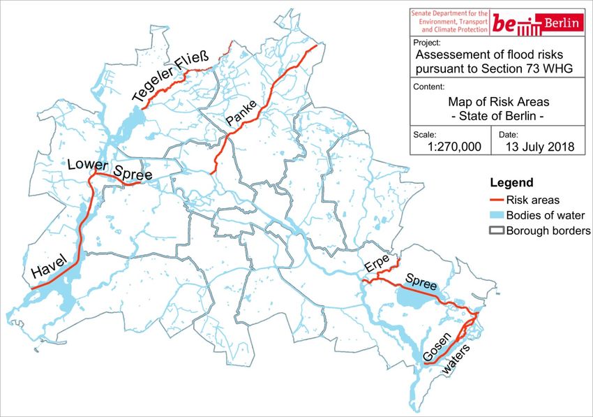
Only flood areas with a substantial risk of flooding are identified in risk areas. The flood risk
assessment in accordance with Directive 2007/60/EC of the European Parliament and of the Council
on the assessment and management of flood risks (FRMD) revealed that there is a potential
significant risk of flooding in the following areas: Tegeler Fließ, Panke, Erpe, Lower Havel / Lower
Spree and Müggelspree, including the Gosen waters including Seddin Lake. These were therefore
defined as risk areas in accordance with Section 73 WHG (see Figure 1; SenUVK 2018).
1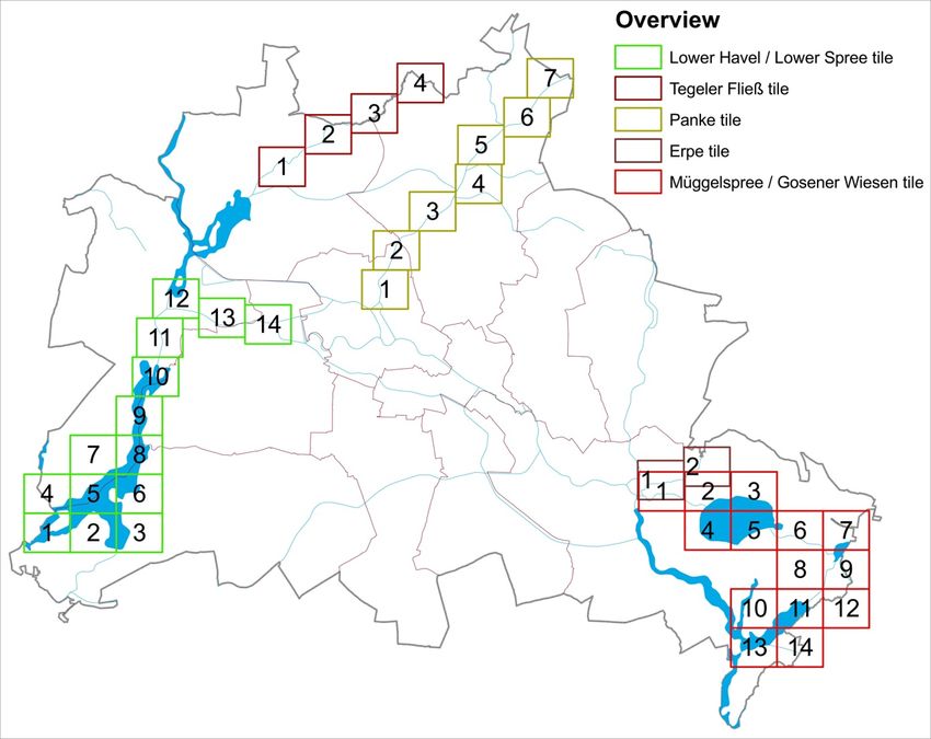
Fig. 1: Risk areas in Berlin (SenUVK 2018)

Statistical Base
The follwing resources provided the main basis for identifying the flood areas:
    -   digital terrain models – ATKIS DTM1 (Geoportal Berlin / ATKIS® DTM - Digital Terrain Model),
    -   100-year flood water levels (IWU 2015, IWU 2014, IPS 2013, IPS 2009 and Koenzen et al.
        2011),
    -   Gauge readings over time, and,
    -   Gewässerkarte (Map of Bodies of Water) (Geoportal Berlin / Gewässerkarte, as of May 1,
        2017).
For a more detailed definition of the statistical base, please refer to the studies in Table 1.

Methodology
Determining the flood areas initially involved mirroring the water levels of a 100-year flood in order to
derive a water surface. Subsequently, this information was collated with the current Digital Terrain
Model (ATKIS® DTM) of the Senate Department for Urban Development and Housing. To differentiate
between flooded areas and bodies of water, the Gewässerkarte (Map of Bodies of Water) was
superimposed on this data.
The water levels of a 100-year flood were determined using several methods. This required, on the
one hand, a joint approach with the State of Brandenburg, as some bodies of water flow from
Brandenburg to Berlin and as the Havel flows back from Berlin into Brandenburg. On the other hand,
this involved adapting the methodology to suit the natural conditions and data availability. The
chapters focussing on the individual flood areas detail the methodological approaches taken. Table 1
provides an overview of all methods and references to further studies. Please refer to the respective
studies for a more detailed description of each method.

                                                     2
Tab. 1: Flood areas and methods used
Flood area Method Study
Müggelspree and Gosener Wiesen hydrodynamic model IWU 2015
Lower Havel / Lower Spree gauge statistics IWU 2014
Erpe precipitation-runoff model combined IPS 2013
with hydraulic model
Panke precipitation-runoff model combined IPS 2009
with hydraulic model
Tegeler Fließ precipitation-runoff model combined Koenzen et
with hydraulic model al. 2011
Tab. 1: Flood areas and methods used
Müggelspree and Gosener Wiesen flood area
Berlin’s Müggelspree and Gosen Canal are located in the backwater areas of the Mühlendamm
impoundment. The water levels are mainly controlled by the weirs and locks at the Mühlendamm lock,
the Kleinmachnow lock and the Oberschleuse (upper lock). Due to the impoundment’s control system
and its large retention capacity, the annual flow throughput and water levels are not always directly
linked. Flood damage does not necessarily have to be linked to abnormally high Spree inflows.
Previsouly, control was adjusted depending on the situation and other premises.
In the process of defining flood areas, comprehensive investigations were carried out into the potential
influence of purposeful weir control, aiming at minimizing the risk of adverse flood effects. Using the
hydro-numerical model GERRIS/HYDRAX of the German Federal Institute of Hydrology and one-
dimensional non-stationary calculations, the influence of controlling water levels during flooding was
investigated for three severe floods in 1975, 1994 and 2011. Control strategies were developed in
collaboration with the Wasserstrassen- und Schifffahrtsamt Berlin (Waterways and Navigation
Authority) based on past events and taking into account existing objectives and restrictions: in the
event of flooding, flood damage in settlement areas is to be minimized, damage to timber building
supports is to be prevented by lowering the water level in the weir of the Mühlendamm lock as
required and navigation is to be continued for as long as possible.
The results demonstrate that the effects of flood discharge from the Spree can be reduced by
controlling the weirs accordingly. The spatially distributed water levels shown in the flood area maps of
a 100-year flood are based on the water level gradient. An administrative agreement was concluded
between the Generaldirektion Wasserstraßen und Schifffahrt (General Directorate Waterways and
Navigation) as the authority overseeing the Berlin Wasserstraßen und Schifffahrtamt (Waterways and
Navigation Authority) (which operates weirs and locks) and the Senate Department in order to
decrease adverse effects of flooding by proactively controlling the water levels of the Berlin
impoundment.
The results of the State of Brandenburg were taken over for the Gosener Wiesen area, as, in the event
of flooding, the border between Berlin and Brandenburg is flooded, too, and the developed method
does not cover this area (IWU 2015).
3Lower Havel / Lower Spree flood area
The Lower Havel / Lower Spree flood area is within the responsibility of the Brandenburg
impoundment. The strategy was adapted to that of the State of Brandenburg in order to guarantee a
methodically uniform approach for the Brandenburg impoundment. For the period from 1964-2013, a
statistical analysis of water level outliers was carried out for seven gauges (Charlottenburg Unterpegel
(UP, Downstream Gauge), Sophienwerder, Spandau UP (Downstream Gauge), Freybrücke /
Tiefwerder, Pfaueninsel, Potsdam Abz. (Outer District) and Potsdam Lange Brücke). These flood
levels serve as supporting points for the water level gradient of a 100-year flood. The water levels
were derived by linear interpolation of the supporting points taking into account the gradient change
caused by different flows and cross-sections. The flood area was divided into flow-through (Lower
Havel I flood area) and impounded (Lower Havel II flood area) sections in order to standardize specific
exceptions to use restriction based on hydraulic conditions (IWU 2014).
Erpe, Panke and Tegeler Fließ flood areas
The methodology for determining the Erpe, Panke and Tegeler Fließ flood areas is fundamentally the
same. In order to determine the flow rates for a 100-year flood, a hydrological precipitation runoff
model was developed for the corresponding catchment area, taking into account the relevant runoff-
forming factors such as land use, topography, soil conditions, impervious soil coverage as well as
influences of management and rainwater discharges. This model was calibrated and verified using
precipitation and climate data as well as recorded runoffs. The runoff measurements were then used
as input variables for the hydraulic model to calculate water levels and flow conditions. One-
dimensional non-stationary models were used. The hydraulic models are mainly based on geometric
data on flow cross-sections, flow conditions and roughness. For this purpose, cross-sections used
during measuring using DTMs were extended to include foreshore areas. The hydraulic model was
also calibrated and verified referring to the existing water level hydrographs and water levels recorded
in the measuring process. Using this model, the water levels for a 100-year flood were calculated (IPS
2009, IPS 2013 and Koenzen et al. 2011).
Map Description
The map of flood areas defined for the State of Berlin shows the location of the five flood areas as
stipulated on 23 October 2018 (GVBl. 27 November 2018):
• Erpe flood area
• Müggelspree and Gosener Wiesen flood area
• Panke flood area
• Tegeler Fließ flood area
• Lower Havel / Lower Spree flood area
The protective provisions of Section 78 WHG shall apply upon the determination of the flood areas.
They include structural restrictions, use restrictions and water protection. The provisions of the
individual ordinances, which determine the flood areas, supplement and in part mitigate these
protective provisions. Depending on the size of the area, each ordinance includes between 2 to 14
maps. The maps show the area and boundaries of the defined flood areas at a scale of 1 : 2,500.
Figure 2 shows an overview of the individual map sheets (tiles).
4Fig. 2: Overview of map sheets (tiles) for each flood area (SenUVK 2018)
In the flood area map, the outer edges of a hatched area determine the boundaries of the respective
flood area. The body of water itself including its shores are not part of the flood area. The maps also
display the contour lines of the water levels for the flood areas Lower Havel / Lower Spree and
Müggelspree / Gosener Wiesen. The Lower Havel / Lower Spree flood area is divided into flood areas
Lower Havel I and Lower Havel II, in order to standardize specific exceptions to use restriction based
on hydraulic conditions.
The five flood areas of Berlin cover a total area of 6.8 km² and account for almost 0.3 % of the total
city area (see Table 2).
Tab. 2: Size of defined flood areas
Flood area Size [km²]
Müggelspree and Gosener Wiesen 2.6
Lower Havel / Lower Spree 2.2
Erpe 0.5
Panke 0.5
Tegeler Fließ 1.0
Total 6.8
Tab. 2: Size of defined flood areas
5Literature
[1] Directive 2007/60/EC of the European Parliament and of the Council
of 23 October 2007 on the assessment and management of flood risks
Internet:
https://eur-lex.europa.eu/legal-content/EN/TXT/PDF/?uri=CELEX:32007L0060&from=EN
(Accessed on 12 December 2018)
[2] FRMD plan, 2015:
Hochwasserrisikomanagementplan gem. § 75 WHG bzw. Artikel 7 der Richtlinie 2007/60/EG
über die Bewertung und das Management von Hochwasserrisiken für den deutschen Teil der
Flussgebietseinheit Elbe [Flood risk management plan pursuant to Section 75 WHG or Section
7 of Directive 2007/60/EC on the assessment and management of flood risks for the German
Elbe River Basin District]
Internet:
https://www.fgg-elbe.de/hwrm-rl/hwrm-plan.html [only in German]
(Accessed on 20 December 2018)
[3] GVBl. [Law and Ordinance Gazette] 27 November 2018:
Senate Department for Justice, Consumer Protection and Anti-Discrimination (ed.). 74(28). 27
November 2018. Berlin.
Internet:
https://www.berlin.de/sen/justiz/service/gesetze-und-verordnungen/2018/ausgabe-nr-28-vom-
27-11-2018-s-657-672.pdf [only in German]
(Accessed on 12 December 2018)
[4] IPS (Engineering bureau Prof. Sieker mbh) 2009:
Modellanpassung und Aufstellung eines integralen Hochwasserschutz- und
Regenwasserbewirtschaftungskonzepts Panke. [Model adaptation and compilation of an
integrated flood protection and rainwater management concept “Panke”]. Unpublished.
[5] IPS (Engineering bureau Prof. Sieker mbh) 2013:
Hydrologische und hydraulische Berechnungen für den Unterlauf der Erpe. [Hydrological and
hydraulic calculations for the lower course of river Erpe]. Unpublished.
[6] IWU (Ingenieurbüro für Wasser und Umwelt) [Engineering office for water and the
environment] 2014:
Zuarbeiten zur Erstellung von Hochwasserrisiko- und –gefahrenkarten für Abschnitte der
Unterhavel und der Spree durch die SenStadtUm Berlin. [Contributions towards the
development of flood risk and flood hazard maps for sections of the Lower Havel and river
Spree by the Berlin Senate Department for Urban Development and the Environment].
Unpublished.
[7] IWU (Ingenieurbüro für Wasser und Umwelt) [Engineering office for water and the
environment] 2015:
Zuarbeiten zur Erstellung von Hochwasserrisiko- und –gefahrenkarten für Abschnitte der Spree
und der Gosener Gräben durch die SenStadtUm Berlin. [Contributions towards the development
of flood risk and flood hazard maps for sections of the Spree and the Gosener Graben by the
Berlin Senate Department for Urban Development and the Environment]. Unpublished.
[8] Koenzen, Steinrücke, Kinst, Amberge and Vogel 2011:
Vorbereitende Maßnahmenplanung im Einzugsgebiet des Tegeler Fließes [Preparatory action
planning in the catchment area of Tegeler Fließ].
Internet (Short report):
https://www.berlin.de/senuvk/umwelt/wasser/download/fliess_planbericht-kurz.pdf [only in
German]
(Accessed on 7 December 2018)
[9] SenUVK (Senate Department for the Environment, Transport and Climate Protection)
2018:
Überprüfung der vorläufigen Bewertung des Hochwasserrisikos und der Risikogebiete in Berlin
[Flood risk and flood risk areas in Berlin – check and preliminary assessment]
Internet:
https://www.berlin.de/senuvk/umwelt/wasser/hochwasser/download/Bewertung_Hochwasserrisi
kos_Berlin.pdf [only in German]
(Accessed on 7 December 2018)
6[10] Verordnung zur Festsetzung des Überschwemmungsgebietes Erpe:
(Überschwemmungsgebietsverordnung Erpe). [Ordinance for the definition of the Erpe flood
area: (Erpe flood area ordinance)] of 23 October 2018.
Internet:
https://www.berlin.de/senuvk/umwelt/wasser/hochwasser/de/karten_festsetzung/erpe/uebersch
wemmungsgebietsverordnung_Erpe.pdf [only in German]
(Accessed on 23 January 2019)
[11] Verordnung zur Festsetzung des Überschwemmungsgebietes Müggelspree und Gosener
Wiesen:
(Überschwemmungsgebietsverordnung Müggelspree/Gosener Wiesen). [Ordinance for the
definition of the Müggelspree and Gosener Wiesen flood area: (Müggelspree / Gosener Wiesen
flood area ordinance)] of 23 October 2018.
Internet:
https://www.berlin.de/senuvk/umwelt/wasser/hochwasser/de/karten_festsetzung/mueggelspree/
ueberschwemmungsgebietsverordnung_Mueggelspree-Gosener_Wiesen.pdf [only in German]
(Accessed on 23 January 2019)
[12] Verordnung zur Festsetzung des Überschwemmungsgebietes Panke:
(Überschwemmungsgebietsverordnung Panke). [Ordinance for the definition of the Panke flood
area: (Panke flood area ordinance)] of 23 October 2018.
Internet:
https://www.berlin.de/senuvk/umwelt/wasser/hochwasser/de/karten_festsetzung/panke/uebersc
hwemmungsgebietsverordnung_Panke.pdf [only in German]
(Accessed on 23 January 2019)
[13] Verordnung zur Festsetzung des Überschwemmungsgebietes Tegeler Fließ:
(Überschwemmungsgebietsverordnung Tegeler Fließ). [Ordinance for the definition of the
Tegeler Fließ flood area: (Tegeler Fließ flood area ordinance)] of 23 October 2018.
Internet:
https://www.berlin.de/senuvk/umwelt/wasser/hochwasser/de/karten_festsetzung/fliess/uebersch
wemmungsgebietsverordnung_Tegeler_Fliess.pdf [only in German]
(Accessed on 23 January 2019)
[14] Verordnung zur Festsetzung des Überschwemmungsgebietes Berliner Havel ab Schleuse
Spandau und Untere Spree ab Schleuse Charlottenburg mit ihren Nebengewässern:
(Überschwemmungsgebietsverordnung Untere Havel/Untere Spree). [Ordinance for the
definition of the Berlin Havel flood area from Spandau lock and the Lower Spree flood area from
Charlottenburg lock including its backwaters: (Lower Havel / Lower Spree flood area ordinance)]
of 23 October 2018.
Internet:
https://www.berlin.de/senuvk/umwelt/wasser/hochwasser/de/karten_festsetzung/unterhavel/ueb
erschwemmungsgebietsverordnung_Untere_Havel-Untere_Spree.pdf [only in German]
(Accessed on 23 January 2019)
[15] WHG (Gesetz zur Ordnung des Wasserhaushalts (Wasserhaushaltsgesetz) [Federal
Water Act]:
Wasserhaushaltsgesetz vom 31. Juli 2009 (BGBl. I S. 2585), das zuletzt durch Artikel 2 des
Gesetzes vom 4. Dezember 2018 (BGBl. I S. 2254) geändert worden ist [Federal Water Act
(WHG) of 31 July 2009 (Federal Law Gazette (BGBl.) I p. 2585., last amended by Article 2 of
the law of 4 December 2018 (BGBI.) p. 2254]
Internet:
https://www.gesetze-im-internet.de/whg_2009/ [only in German]
(Accessed on 12 December 2018)
7You can also read