Staffordshire Moorlands District Integrated Transport Strategy 2018 2031 - October 2018 - Staffordshire ...
←
→
Page content transcription
If your browser does not render page correctly, please read the page content below
Staffordshire Moorlands

District Integrated
Transport Strategy
2018 - 2031

October 2018
Contents

1.   Introduction

2.   District Profile

     Introduction
     Highway Issues
     Social Issues
     Public Transport Issues

3.   Staffordshire Moorlands District Local Plan

     Introduction
     Housing
     Economy and Employment

4.   Recent Transport Achievements

     County Council Capital Programme
     Alton Towers Resort Transport Strategy
     Sustainable Transport

5.   Transport Strategy

     Introduction
     Economic Growth
     Housing
     Education and Skills
     Health, Care and Wellness

6.   Making It Happen

     Decision Process
     Delivery Programme
     Funding Opportunities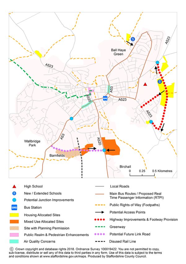
1. Introduction
1.1   Integrated Transport Strategies have been developed for the eight District /
      Boroughs in Staffordshire to help prioritise the County Council’s expenditure
      on transport improvements in the short term and during the period of the
      planning authority’s Local Plan. The objectives of the Staffordshire Moorlands
      Integrated Transport Strategy are as follows:

                         Objectives of the Transport Strategies

              • Summarise the key highway and transport issues
              • Integrate transport and planning policy
              • Identify transport solutions that will help to:
                o Achieve Staffordshire County Council vision and outcomes
                o Deliver the Local Plan
                o Support Local Enterprise Partnership objectives
                o Reflect communities concerns
              • Outline funding options and delivery mechanisms

1.2   Delivery of this Transport Strategy will help achieve Staffordshire County
      Council’s vision for Staffordshire and three interconnected priority outcomes
      that are identified in the County Council’s Strategic Plan for 2018 to 2022.

                                            Vision

                ‘A Connected Staffordshire, where everyone has the
                   opportunity to prosper, be healthy and happy’.
        The people of Staffordshire will:

        • Be able to access more good jobs and feel the benefit of economic growth
        • Be healthier and more independent
        • Feel safer, happier and more supported in and by their community

1.3   It will also help to achieve the Stoke-on-Trent and Staffordshire Local
      Enterprise Partnership (LEP) objectives of creating Competitive Urban
      Centres and a Connected County. A priority for the LEP during the period up
      to 2021 is to develop our local transport networks to provide sustainable
      connections and unlock housing, town centre and employment growth.

1.4   There is strong policy support for the delivery of this Strategy in the
      Staffordshire Moorlands Local Plan for the period up to 2031. In particular, it
      reflects the need to deliver housing, employment and tourism growth in the
      District. Scheme proposals take into consideration local concerns highlighted
      through consultations with local councillors. Local research recognises that
      traffic issues and improving the conditions of roads and pavements is
      considered important for Staffordshire Moorlands residents.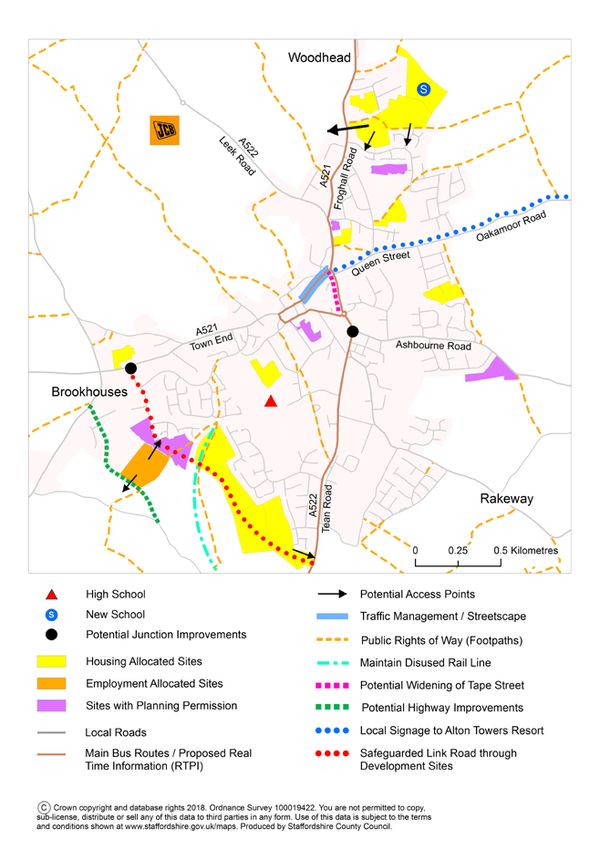
2.    District Profile

      Introduction
2.1   Staffordshire Moorlands is a rural District bordered by Cheshire, Derbyshire,
      Stoke-on-Trent and the Boroughs of Newcastle-under-Lyme, Stafford and
      East Staffordshire. The three towns of Biddulph, Cheadle and Leek play
      important roles in providing services, facilities and opportunities for new
      housing and employment.

2.2   The A523 provides links to Cheshire and Derbyshire and the A52, A53 and
      A527 are key routes to Stoke-on-Trent and the Peak District. The A520, A521
      and A522 provide access to the A50(T) in the south of the District. The
      number of residents in the Staffordshire Moorlands driving to work is higher
      than the national average, at 79% (2011 Census).

2.3   There is one mainline rail station in Staffordshire Moorlands at Blythe Bridge
      situated on the North Staffordshire Line between Crewe, Stoke-on-Trent and
      Derby. The station and train services are operated by East Midlands Trains.
      Residents are also able to access rail stations outside of the District, for
      example in Stoke-on-Trent, Kidsgrove, Uttoxeter, Congleton and Macclesfield.

2.4   Around 3.5% (2011 Census) of employed residents in Staffordshire Moorlands
      District travel to work by bus or rail which is around the average for
      Staffordshire as a whole. Over 90% of the bus network in Staffordshire is
      provided on a commercial basis by private bus operators. The main operators
      in the District are First Potteries, D&G and Taxico.

2.5   Staffordshire Moorlands has around 1,400km of rights of way and bridleways
      which is 30% of the total Staffordshire network, including the Peak Park.
      There are also additional popular leisure trails along river valleys and disused
      rail lines.

      Highway Issues
      Condition of Local Roads
2.6   The County Council is responsible for maintaining the condition of the local
      highway network through the Infrastructure+ Partnership with Amey. The
      maintenance of street lighting is the responsibility of a Private Finance
      Initiative (PFI) contract to secure increased capital investment to remedy a
      rapidly deteriorating lighting stock.

2.7   The majority of road works are carried out by utility companies such as gas,
      water, phone and electric companies, and by developers. County Council
      maintenance activity is planned ahead to enable co-ordination with utility
      works and any other third party activities to minimise the frequency and
      duration of disruptive road works.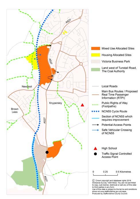
2.8   Preventative and structural highway maintenance schemes are predominantly
      identified through condition surveys. All ‘A’ and ‘B’ classification roads within
      the District are surveyed annually and lower class roads, less frequently. The
      condition of bridge structures is assessed using standardised national
      guidelines to enable comparisons to be made between local authorities. Any
      bridge assessed as being in a critical condition requires priority investment.

2.9   Table 2.1 identifies the proportion of Staffordshire’s roads that are in
      Staffordshire Moorlands by classification and Table 2.2 identifies the
      proportion of roads where essential structural maintenance is required as a
      percentage of the total roads in Staffordshire, based on the latest Road
      Condition Indicator data. Staffordshire Moorlands (including the Peak Park)
      has a high proportion of the ‘A’, ‘B’ and ‘C’ roads in the County that are a
      priority for maintenance as well as a higher proportion of the unclassified / D
      roads requiring priority maintenance works.

      Table 2.1 Length of Road by Classifications (metres)
                                                                       Unclassified /
       Location                    A Roads          B and C Roads
                                                                       D Roads
       Staffordshire               1,264,410        1,972,753          2,636,265
                                   231,947          390,871            504,673
       Staffordshire Moorlands
                                   18%              20%                19%

      Table 2.2: Roads Requiring Essential Structural Maintenance (as % of
      roads in Staffordshire)
                                                                       Unclassified /
       Location                    A Roads          B and C Roads
                                                                       D Roads
       Staffordshire               2.61%            7.2%               11.2%
       Staffordshire Moorlands     0.65%            2.0%               3.1%

2.10 To further prioritise potential structural maintenance schemes, beyond defects
     alone, a value management approach is adopted through priority scoring
     matrices which take into consideration other attributes including level of traffic,
     drainage issues, whether it is a winter-maintenance or bus route, the quality of
     the ride and the accident rate.

      Traffic Concerns
2.11 A traffic analysis has been completed for 2016/17 using Highways Analyst
     software and Trafficmaster historic journey time data provided by the
     Department for Transport. It concludes that the highway network in Leek is
     considered to operate within capacity and is expected to be able to
     accommodate the level of development proposed in the Local Plan. There
     can be short queues at key junctions on the A53 in the town centre during
     peak periods and there are local concerns about the A53 / A520 and A53 /
     Junction Road junctions.

2.12 In 2015, a transport study for Cheadle was produced by Amey consultants. A
     robust dataset was used including traffic and pedestrian counts, and
     automatic number plate recognition, journey time and queue length surveys.
     The assessment was undertaken for current traffic flows and forecast traffic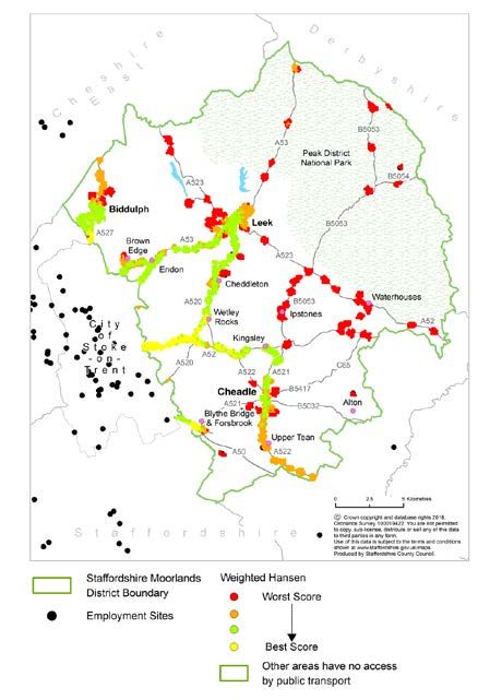
levels associated with development allocated in the Local Plan, using the
      microsimulation software VISSIM.

2.13 The study concludes that the overall network in Cheadle generally operates
     within capacity. However during the PM peak hour there is currently queuing
     traffic southbound along the A522 Leek Road and Tape Street and westbound
     along Queen Street. The proposed development sites in Cheadle will
     exacerbate this problem, with queuing in future years likely along these
     corridors in both the AM and PM peak hours, with additional queuing
     northbound on Tape street at the junction with Ashbourne Road. Traffic
     delays on High Street tend to be the result of inappropriate parking and
     loading. Appropriate mitigation measures will be required to help relieve
     these traffic issues.

2.14 Freight traffic on the local highway network is typically around 5–10% of all
     traffic, although this may be higher where there are major freight destinations,
     such as JCB. Much of the freight traffic in rural areas has a legitimate right of
     access to a point of collection or delivery and is related to a local business
     operation. The small proportion of freight traffic that is using the rural network
     inappropriately however is of considerable concern to local communities.
     Figure 2.1 indicates which routes have the highest volumes of freight traffic in
     the District.

      Figure 2.1: HGV Two Way Flows

      Car Parking
2.15 Staffordshire Moorlands District Council employs a pay and display charging
     structure for the majority of their public off-street car parks in Leek, Cheadle
     and Biddulph. In the smaller settlements of Blythe Bridge, Forsbrook,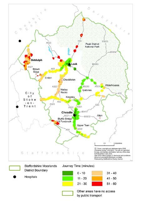
Oakamoor, Tean and Wetton public off-street car parks are free to use. On-
      street parking enforcement is the responsibility of the County Council and the
      police deal with illegal obstructions and dangerous parking.

2.16 The County Council’s Community Liaison Team is aware of issues relating to
     all-day on-street parking in residential areas close to town centres which can
     cause concerns for residents. They are also aware of on-street parking issues
     which are thought to relate to Blythe Bridge rail station due to avoidance of
     parking charges by rail users, and in the vicinity of schools.

      Road Safety
2.17 The Staffordshire Safer Roads Partnership was established in 2001 to bring
     together Staffordshire Police, Staffordshire County Council, Staffordshire Fire
     and Rescue Service, Stoke-on-Trent Council and Highways England. The
     Partnership has helped to achieve road safety improvements through a
     combination of education, training, publicity, enforcement and engineering.
     Department for Transport data confirms that Staffordshire has one of the
     safest road networks in the country.

2.18 The Staffordshire Moorlands District Road Safety Profile 2017 provides a high
     level overview of key themes and trends in terms of collisions with injury.
     Staffordshire Moorlands is at the lower end of the scale compared to other
     local authority areas. The profile shows a steadily declining trend in the total
     number of collisions over the last 5 years in the District. This trend is mirrored
     across some of the most vulnerable road user groups, including motorcyclists,
     pedestrians and young drivers/riders. However the volume of pedal cyclists
     and child pedestrians involved in collisions has remained fairly consistent.

2.19 This collision data provides a good indication of where to focus road safety
     initiatives. The data is continually monitored and locations are identified where
     consistent accident patterns occur that might be prevented through remedial
     engineering works.

      Local Transport Issues
2.20 Staffordshire County Council logs all customer enquiries received relating to
     highways, traffic, waste, lighting and safety. County Councillors also work
     closely with the County Council’s Neighbourhood Highway Team to ensure
     that local traffic concerns are identified and priorities are established. The
     team visits each community a minimum of twice per year. The main issues
     raised in Staffordshire Moorlands in 2018/19 included:

      • Review of car parking and Traffic Regulation Orders on High Street,
        Biddulph
      • Concerns relating to traffic flows through Leek town centre and the impact
        of inappropriate use by traffic of residential streets
      • Review of traffic volumes on local roads in Cheadle
      • Community support for introduction of 30mph speed limits through villages
      • Traffic speed concerns and consideration of pedestrian facilities in Endon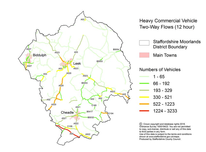
Walking and Cycling Issues
2.21 Staffordshire County Council is responsible for the maintenance of facilities on
     the local highway and public rights of way. Under a management agreement
     the County Council maintains the rights of way network within the
     Staffordshire section of the Peak District National Park. A Parish Council has
     the power to maintain footpaths or bridleways in its area, but this does not
     remove responsibility from the County Council. General issues on the rights
     of way network include poor surfacing, overgrown vegetation and a lack of
     signing.

2.22 The overall quality of the network available to walkers in Staffordshire
     Moorlands is good, but the percentage of the network available to cyclists is
     relatively low and fragmented. There are a number of popular leisure routes
     including Greenways that are owned by the County Council and the canal
     network that is managed by the Canal and River Trust. The Caldon Canal
     extends through Staffordshire Moorlands District with branches from Froghall
     and Leek into the conurbation of Stoke-on-Trent and the respective towpaths
     are popular pedestrian and cycle routes. All these routes can provide
     valuable linkages between communities.

      Social Issues
      Health

2.23 Regular physical activity through walking and cycling has been shown to
     tackle physical and mental health issues, reduce preventable deaths, improve
     educational attainment and increase independence in older people. The
     District has a higher number of people on average with disabilities that affect
     their day-to-day activities compared to Staffordshire as a whole. This is
     highlighted as an issue in the Local Plan.

2.24 Levels of excess weight in children in Staffordshire Moorlands are similar to
     the national average. Around 65% of adults have excess weight which is
     similar to the England average.

2.25 Over half of Staffordshire Moorlands adults meet the recommended levels of
     physical activity; similar to the national average. Approximately one in four
     Staffordshire Moorlands adults are physically inactive, equating to around
     23,000 people. These levels of physical activity are similar to the England
     average.

      Air Quality

2.26 Staffordshire Moorlands District Council is responsible for the monitoring of air
     quality across the District. No Air Quality Management Areas have been
     declared in the District however there are a number of locations of concern
     due to exceedances of NO2, as follows:
• Cellarhead crossroads, due to the proximity of residential properties close
        to the A520/A52 traffic signal controlled junction where there can be
        queuing traffic, including heavy goods vehicles
      • Ball Haye Street and Broad Street in Leek, with A53 Brook Street and
        Haywood Street also being closely monitored for exceedances
      • A522 Tape Street, Cheadle, is being monitored for exceedances in the
        vicinity of residential properties adjacent to queuing traffic at peak times

      Accessibility
2.27 In order to create an inclusive society that promotes equality of access and
     opportunity, destinations need to be as accessible to as many people as
     possible. Reasonable steps must be taken to remove barriers to access,
     making the transport system easier to use and places easier to get to. Until
     barriers are removed, a proportion of people will be disadvantaged; unable to
     access the jobs, services and activities they want; and limited in the extent to
     which they can participate in society. Individuals most likely to be affected
     include the elderly, the young, those with a temporary or permanent disability
     and those without access to a private motor vehicle.

2.28 An assessment has been completed to shows levels of accessibility by public
     transport to hospitals and employment for residents in Staffordshire
     Moorlands. The results shown in Figure 2.2 highlight the large areas of the
     District that have no access and the corridors and settlements that have the
     shortest journey times to hospitals and the best access to jobs.

      Figure 2.2: Access to hospitals and Employment
Public Transport Issues
       Rail
2.29   Train operating companies (TOCs) are private companies, paid to run
       franchises by Central government. Network Rail owns and maintains the rail
       network, and the ORR (Office of Rail and Road) regulate Network Rail and
       TOCs. In Staffordshire Moorlands, Blythe Bridge station is operated and
       served by East Midlands Trains. The new East Midlands rail franchise is due
       to begin in late 2019, with four consortia presently bidding for the new
       franchise.

2.30 Stations are classified into six categories (A-F) based on passenger footfall
     and income. Blythe Bridge station is an ‘F’ class small unstaffed station. This
     class of station tends not to be a priority for investment and traditionally has
     been dependent upon funding opportunities such as the National Stations
     Improvement Programme and Access for All funding.

2.31   Blythe Bridge station has a small car park with room for 20-30 cars. At
       present there are no issues with capacity at the car park, although future
       housing development and improvements in service could see an increase in
       demand. An hourly service is provided at the station during the week, on
       Saturdays and on Sundays (from 14.30 onwards). The services on this line
       are operated mainly by single carriage units which frequently suffer from
       overcrowding.

       Bus
2.32 Access to frequent bus services varies across the main towns within the
     District. Access in terms of the number of addresses within 350 metres of a
     half hourly or more frequent weekday service is summarised in Table 2.3.
     The County Council supports the use of these services by supplying Traveline
     with bus timetable information and journey planning information.

       Table 2.3: Access to Frequent Bus Services
        Main Town                 Addresses within 350m of frequent service
        Biddulph                  59.5% (April 2018)
        Cheadle                   40.5% (April 2018)
        Leek                      69.5% (April 2018)

2.33 The County Council has a statutory duty under the Transport Act 1985 to
     secure bus services that are considered to be socially necessary. Statutory
     supported services include:

       • Mainstream home to school transport for qualifying children
       • Older persons and disabled concessionary fares from 9.30am
       • Home to school transport for children with Special Educational Needs
         (SEN)

2.34 The countywide budget for the provision of additional discretionary services is
     regularly reviewed to help meet the County Council’s budget savings.
Funding decisions are made with the aim of retaining the greatest number of
existing journeys that are not possible on the commercial bus network, whilst
minimising the level of public subsidy. Recent budget savings have had the
following impact on the level of discretionary services provided by the County
Council in Staffordshire Moorlands District:
• A reduction in supported services (largely evening and Sunday services)
where a commercial service is not currently available. This includes:
- Withdrawal of the service between Leek and Biddulph
- Reduction in the number of journeys between Leek and Cheadle
- Reduction in the number of journeys on a Saturday between Leek and
Ashbourne
- No services to Alton, Foxt and Whiston
• A reduction in the operation of the Moorlands Connect service from two
vehicles to one vehicle, delivered by Ashbourne Community Transport
• Retention of SEN Post 16 transport scheme that includes travel to 6th form
and college
• Phasing out, by September 2019, of the ‘Your Staffordshire Card’ that has
provided a reduction in bus journey fares for under 19 year olds3. Staffordshire Moorlands Local Plan
Introduction
3.1 This Transport Strategy aims to support the priorities in the Local Plan, in
particular, Spatial Objective SO11: To reduce the need to travel or make it
safer and easier to travel by more sustainable forms of transport and
associated transport policies T1 and T2. It provides the supporting transport
evidence for Spatial Strategy policies, in particular Policy SS5 (Leek Area
Strategy), Policy SS6 (Biddulph Area Strategy) and Policy SS7 (Cheadle Area
Strategy). It will also complement the Staffordshire Moorlands Infrastructure
Delivery Plan and adopted Green Infrastructure Strategy.
3.2 The Peak District National Park Authority is the planning authority for the
National Park and one third of Staffordshire Moorlands lies inside the Park.
The Peak District National Park Core Strategy was adopted in 2011 and
policies for the National Park up to the year 2026.
3.3 Another opportunity for local transport issues to be raised is through
Neighbourhood Plans that sit alongside the Local Plan. Decisions on planning
applications are made using both the Local Plan and Neighbourhood Plans,
and any other material considerations. Neighbourhood Plans must be in
general conformity with the Local Plan and should not promote less
development. There are no adopted Neighbourhood Plans in the District, but
they are currently being prepared for Biddulph, Brown Edge, Checkley,
Leekfrith, Draycott-in-the-Moors, Rushton, Forsbrook and Leek.
Housing
3.4 The Local Plan sets out how the net housing requirement of 3,859 will be met
across the District up to 2031. 75% will be delivered in the towns of Leek
(1,015 dwellings), Biddulph (885 dwellings) and Cheadle (1,166 dwellings)
with the remainder located in the larger villages and limited development in
other settlements. This proposed distribution of development aims to facilitate
the growth of towns and larger villages where it can be accommodated, whilst
enabling an appropriate scale of development in rural areas to support
sustainable communities. This approach focuses on areas of highest
accessibility that are supported by existing infrastructure or can best facilitate
infrastructure improvements.
Economy and Employment
3.5 Provision will be made for at least 27 hectares of additional employment land
in the District up to 2031 through allocation of sites and through windfall sites.
70% of employment development will be focused on the three main towns
Leek, Biddulph and Cheadle with the remainder allocated to rural areas. The
regional scale allocation at Blythe Bridge, for a 48.5ha mixed use
development with approximately 300 dwellings, is being considered
independently of the general employment land requirements for Staffordshire
Moorlands.4 Recent Transport Achievements
County Council Capital Programme
4.1 In 2017/18 approximately £1.8m was spent on delivering the bridge and
highway maintenance programme, including preventative carriageway and
footway maintenance and pre-patching works, throughout the Staffordshire
Moorlands District. The County Council continues to invest in making further
improvements in highway, transport and communication provision with
ongoing delivery of other routine services including road safety enforcement
and training, on-street parking enforcement and supported bus services.
Funds were also spent on scheme feasibility studies and the delivery of
integrated transport schemes including:
• Bottom House crossroads (A523/B5053)
• A522/A52 speed reduction - Cheadle to Werrington
• Caldon Canal towpath directional and route signing between Stockton
Brook and Cheddleton to enhance recent towpath improvements through
the Pedal Peak project
Alton Towers Resort Transport Strategy
4.2 In 2010, Staffordshire County Council Cabinet approved the approach to
managing the transport impact of Alton Towers Resort Long Term Plan for
2010 to 2019 and agreed to work with the Resort through a Transport Liaison
Group to help mitigate the impact of associated future traffic growth. Traffic
monitoring and transport measures have been resourced using annual S106
payments made by Alton Towers Resort, dependent on levels of annual visitor
numbers. This funding pot was significantly boosted in 2013 with the award of
Local Pinch Point Funding from Government for a junction improvement at
Denstone in East Staffordshire.
4.3 Since 2010, the following transport strategy measures have been delivered:
• Informal pedestrian crossing in Alton with changes to the build out at
Dimble Lane
• Temporary use of Speed Indication Devices through Alton
• Signing and road marking improvements at Denstone Lane / Saltersford
Lane / Uttoxeter Road junction
• Parking restrictions on Wootton Lane
• Signing and road marking improvement on Farley Lane at Alton Towers
Resort Gate 1
• Bus shelter within the main entrance at Farley
• B5032/B5031 junction improvement, Denstone
• Alton Towers Resort Bookable Bus serving local accommodation providers
(ran for two seasons)
• Route Signing StudySustainable Transport
Active Travel to School
4.4 Bikeability National Standard Training is delivered by local providers on behalf
of the County Council through additional funding secured from the
Department for Transport (confirmed until 2020). Around 1,000 school
students in Staffordshire Moorlands receive Bikeability cycle training each
year, with additional Bikeability Plus modules developed to complement on-
road training. Training also takes place during school holidays, with 200
places offered at local leisure centres. Schools are also encouraged to take
part in the Modeshift Stars Programme enabling them to create, develop,
implement, monitor and maintain their own travel plan to promote active travel
to school.
Rights of Way Network
4.5 Staffordshire County Council works with a number of voluntary groups in
Staffordshire Moorlands to undertake clearance of paths and repairs to path
furniture such as stiles. The Forsbook Volunteers undertake path
maintenance and liaise with landowners to get issues resolved. An
Enforcement Policy has also been introduced to give Officers the ability to
react positively to landowners who flout the law and ignore their
responsibilities for keeping the path network free of obstructions.
Superfast Staffordshire
4.6 The Superfast Staffordshire project is a partnership between Staffordshire
County Council, Broadband Delivery UK (BDUK) and BT. Superfast
Broadband refers to speeds greater than 24mbps and currently 89% of
businesses and households have access to it. Throughout Staffordshire, the
County Council is investing £8.06 million, which is being match-funded with
£9.12 million from BDUK and a further £14.77 million from BT. Public funds
are focusing on bringing faster broadband services to areas of the County that
are not expected to receive private investment. Many of these areas are rural
in nature and are outside the commercial roll-out area.
Blythe Bridge Rail Station
4.7 Blythe Bridge rail station is part of the North Staffordshire Community Rail
Partnership, maintained by volunteers. With support from Staffordshire
County Council, Forsbrook Parish Council, East Midlands Trains and the local
community, the Partnership has delivered a package of improvements at the
station including: new waiting shelters, platform seating, CCTV and customer
information screens. Annual passenger footfall has increased by nearly 150%
in the last 10 years to over 90,000 which has been achieved despite very
limited changes in the frequency and capacity of rail service provided.5 Transport Strategy
Introduction
5.1 The Transport Strategy explains what transport schemes and initiatives we
intend to deliver in Staffordshire Moorlands to help achieve the County
Council’s following priorities as identified in the Strategic Plan for 2018 to
2022.
Staffordshire County Council’s Priorities
Economic Housing Education and Health, Care and
Growth Skills Wellbeing
• Strategic
• Place and Infrastructure • Support to the most • Health and
Infrastructure: Plan: construction vulnerable in our wellbeing shaping
creating the right of more homes, communities, all policies and
mix of attractive importantly making including children decisions about
destinations with sure they are with special housing,
good transport supported by educational needs economy, retail,
connections employment, high and disabilities infrastructure,
quality transport, leisure and green
green spaces, spaces
places to go and
digital connections
Economic Growth
Introduction
5.2 Delivery of a sustainable and connected transport system with reduced traffic
delays and improved reliability is fundamental to creating the right conditions
for economic growth allowing residents to access more good jobs. The
County Council aims to make Staffordshire a well-connected location through
investment in road, rail and digital communications.
5.3 Staffordshire County Council is a partner of Midlands Connect which is the
transport element of Midlands Engine. Midlands Connect is an initiative
driven by Local Enterprise Partnerships and local authorities to ensure that
the Midlands is fully positioned to influence future strategic transport funding
programmes. In 2017, the Midlands Connect Strategy was published and has
the following priorities:
• Making the most of HS2
• Linking to international gateways
• Improving East-West connectivity across the Midlands
• Strengthening freight corridors
• Making the strategic transport network more resilient
• Opening up land for commercial and residential development• Connecting our urban centres providing capacity for growth
5.4 The Constellation Partnership is a group of local authorities and Local
Enterprise Partnerships in Cheshire and the north of Staffordshire that have
come together to maximise the potential benefits to the area arising from the
proposed HS2 Hub Station at Crewe and related economic growth
opportunities up to the year 2040.
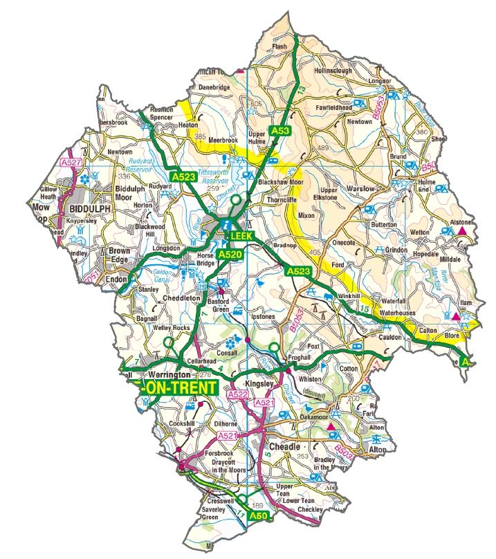
5.5 Figure 5.1 provides an overview of the transport network serving Staffordshire
Moorlands.
Figure 5.1: Transport Overview5.6 Staffordshire Moorlands is home to a number of nationally significant
businesses, including Alton Towers Resort and JCB. A major strength is the
District’s tourism economy that is supported by Alton Towers Resort , Peak
District National Park and heritage rail lines. Large scale major development
areas at Froghall and Blackshaw Moor may also provide future opportunities
to improve the rural economy. Any future development proposals at
Blackshaw Moor on the A53 will need to take account of the air quality impact
on the South Pennine Moors Special Area of Conservation.
5.7 There are also strong cross border links with neighbouring authorities
connected by the local road network and one strategic transport corridor in the
south of the District served by the A50 trunk road and North Staffordshire rail
line between Crewe and Derby, both providing East-West connectivity across
the Midlands. Improvements to this transport corridor are considered key to
the delivery of the Stoke-on-Trent and Staffordshire Local Enterprise
Partnership’s priorities and objectives and Midlands Connect Strategy.
A50(T) Growth Corridor
5.8 The County Council continues to work directly with Highways England to
influence proposals for the A50(T) in the next funding period beyond 2020.
The County Council is also a key partner in the Strategy Study of the
A50/A500 corridor to be completed by Midlands Connect in 2018/19. This will
establish the economic importance of the route and identify an investment
programme to deliver performance improvements.
5.9 Figure 5.2 shows where major development sites within and close to
Staffordshire Moorlands are located along this transport corridor. The 48.5ha
Blythe Vale development site in Staffordshire Moorlands has been identified
by the Constellation Partnership as an investment opportunity. The 58ha
Former Creda Works site at Blythe Bridge, known as Hadleigh Park, is located
within Stafford Borough and is expected to be accessed directly from the
Blythe Bridge A50(T) roundabout junction. The locations for development in
Stoke-on-Trent on Figure 5.2 are identified in the Stoke-on-Trent and
Newcastle-under-Lyme Joint Local Plan Preferred Options Consultation
document.
5.10 It is expected that the cumulative impact of these potential development sites
on the A50(T) and the local network could be significant. As indicated on
Figure 5.2 the potential transport requirements specifically associated with the
major development sites include the following:
• High quality local highway connections to rail stations on the North
Staffordshire rail line
• Bus connectivity for the residents of Staffordshire Moorlands
• Safe and convenient pedestrian and cycle connections to nearby
communities such as Blythe Bridge
• Junction improvements on the A50 and on the local highway network as
identified through detailed traffic appraisals, including the A50/A521
junctionFigure 5.2: A50(T) Growth Corridor
Proposed Major Road Network
5.11 In March 2018, Staffordshire County Council responded to the Department for
Transport’s consultation on the creation of a Major Road Network (MRN). It is
expected that the role of the MRN will be to:
• Provide feeder links to the Strategic Road Network
• Provide cross boundary connectivity
• Provide connectivity to economic centres, regionally significant employment
and transport hubs
• Form an outer ring road or perform a bypass function around major
towns/cities
• Provide resilience for the Strategic Road Network
5.12 Roads requested by Staffordshire County Council to be identified as part of
the MRN in Staffordshire Moorlands are shown on Figure 5.1. The routes
provide key connections across the District and are expected to carry the
largest volumes of traffic. The Department for Transport is expected to
announce the final MRN network in 2018.Rail Network
5.13 Staffordshire’s Rail Strategy 2016 sets out the County Council’s priorities for
rail, providing a sound basis to respond to national rail consultations and help
shape the rail industry’s future investment plans. The North Staffordshire Line
between Crewe, Stoke-on-Trent and Derby serves Staffordshire Moorlands
and is considered by Midlands Connect to be a priority route. A study is being
undertaken by Midlands Connect to identify an investment programme. A
stakeholder board has also been established between businesses
representatives, rail industry and politicians to help bring forward
improvements for the line. The County Council supports the following
improvements related to the North Staffordshire Line:
• Increased capacity, line speeds and re-signalling
• Increased frequency and capacity of services
• New services to Nottingham and Manchester Airport, restoring connections
previously lost
• Later evening services and earlier Sunday services at Blythe Bridge station
to serve the leisure and retail markets
• Additional parking at Blythe Bridge station
5.14 Provided there is a robust business case, the County Council will support in
principle the re-opening of rail lines, taking into account the need to maintain
already established and well used walking and cycling routes, including
Greenways that are not designated rights of way. Re-use is supported for
tourism use and freight and passenger operations. This includes Moorlands
and City Railways proposal to operate freight services between Cauldon Low
and Stoke-on-Trent.
Alton Towers Resort
5.15 The 2010-2019 Alton Towers Resort Transport Strategy will be completed
with the delivery of the Route Signing Strategy that will:
• Remove inaccurate and replace non-compliant signs on main routes used
by visitors
• Enhanced signs to Alton Towers Resort along A52 and directing traffic
away from Cheadle and Oakamoor
• Enhanced signs from Alton Towers Resort clearly signing traffic directly
back to the A50 and A52
5.16 It is anticipated that Alton Towers Resort will be producing a new Long Term
Plan for the period beyond 2019. As this work progresses, it is expected that
the established Transport Liaison Group will consider a new Transport
Strategy to support future growth proposals. Possible transport strategy
measures could include the following:
• Improved entrance to the Resort
• Improvements to Beelow Lane
• Schemes that respond to community traffic and safety concerns• Exploring opportunities to increase public transport journeys to the Resort
• Variable message signs
Freight Strategy
5.17 The Staffordshire Freight and Communities Forum was established in 2016 in
response to a recommendation of the Prosperous Staffordshire Select
Committee. Consequently, a new Freight Strategy for the County of
Staffordshire is due to be published in 2019. The forum brings together key
stakeholders such as local community representatives, Staffordshire County
Council, the Police and Fire Service, Highways England and the Freight
Haulage Association to address the impact of heavy commercial vehicles on
Staffordshire’s roads. The forum aims to develop solutions that reconcile
access requirements with local environmental and social concerns. Potential
measures available to the County Council are listed below:
• Consider requests for environmental weight restrictions on specific parts of
the highway network with regard to sensitivity of the area, quantum of
HGVs, population affected and suitability of alternative routes as well as
issues of route re-classification. The County Council does not generally
consider implementing environmental weight restrictions on A and B
classified routes as these form priority routes linking key destinations and
provide a strategic function
• As mineral and waste planning authority and in consultation with key
stakeholders promote the use of ‘routing agreements’ in relation to major
generators of freight
• Ensure that Travel Plans relating to new development adequately address
freight and delivery issues – including consideration of enforcement
measures
• Vulnerable road user training and education in relation to operation of
HGVs
• Support improvements to HGV parking facilities within Staffordshire,
specifically in the M6-A449, A5-M6 Toll and A38(T) corridors
• Support planning applications that make appropriate provision for new or
extended HGV parking areas subject to environmental and residential
amenity constraints
• Support provision of new and expansion of existing rail freight terminals in
and close to Staffordshire with good access to the Primary Route Network
and close to existing logistics activity
• Maximise opportunities associated with HS2 and the released capacity it
provides
• Investigate environmental impacts of HGVs on key routes including noise
and air quality issues
• Liaise with Staffordshire Police regarding enforcement of existing and
potential HGV restrictions countywide
• Continue to issue considered responses to the Traffic Commissioners in
relation to consultations on HGV operators’ license applications
• Continue to work with Highways England to manage the effects of
emergency diversion routes on the local network and support
improvements to the trunk road networkHousing
Introduction
5.18 The County Council is supporting housing construction by making sure new
developments are supported by connections to employment opportunities,
high quality transport, green spaces, places to go out and digital connections
such as superfast broadband. Sustainable and balanced communities that
have an excellent quality of life are a priority of the Local Plan.
5.19 Local transport strategies for Leek, Biddulph and Cheadle indicate transport
measures that aim to mitigate housing development and support growth in
local jobs. Working with major employment and housing developers is
essential to ensure that access requirements do not have a detrimental impact
on the operation of the local transport network and that sustainable transport
options are maximised.
5.20 Scheme details will be approved with developers following completion of
Transport Assessments. As well as in the main towns, this also applies to
developments in rural areas and villages such as Werrington, Leekbrook and
Endon where traffic impact and sustainable transport provision will require
appropriate consideration, including sustainable links to village facilities.
Leek Local Transport Strategy
5.21 There is a net requirement of 1,015 new homes in Leek during the Local Plan
period. This housing growth is expected to be supported by around 6 ha of
new local employment sites. New housing will largely be located to the east
and the south of the town centre.
5.22 Following consideration of traffic issues in Leek, as summarised in Section 2,
it is considered that although there are some peak hour traffic issues,
development traffic can be adequately mitigated and the required transport
measures can be delivered when necessary.
5.23 A link road between the A520 and A53 is not considered to be required to
mitigate the traffic impact of development proposed for Leek in the Local Plan,
although it would provide improved access to development sites in the south
of the town and Barnfield Industrial Estate and provide an alternative route to
Junction Road. The County Council would therefore support safeguarding the
route as a long term aspiration to allow phased provision in associating with
new development.
5.24 The measures indicated on Figure 5.3, and listed as follows, are
recommended to enable the proposed level of growth:
Sustainable Transport Measures
• Local facilities within housing developments that encourage sustainable
travel, including new and expanded schools
• Bus stop infrastructure and real time bus passenger information• Town centre pedestrian enhancement focused on Edward Street and Stanley Street • Maintenance and enhancement of key footpath and cycle routes and the right of way network, focusing on links to the town centre and schools Highway Measures • Providing adequate site accesses that minimise traffic impact, making use of existing junctions where feasible • Improvements to Mount Road including the provision of footpaths • Upgrade Kniveden Lane to adoptable standard and provision of footpaths • Potential improvements at Mount Road’s junctions with Ashbourne Road and Buxton Road • Potential junction improvement at A53 / Junction Road • Ongoing monitoring of road safety and air quality data that may highlight the need for additional highway improvements Figure 5.3: Leek Local Transport Strategy
Biddulph Local Transport Strategy
5.25 There is a net requirement of 885 new homes in Biddulph during the Local
     Plan period. This housing growth is expected to be supported by around 5 ha
     of new local employment sites. New housing will largely be located at Wharf
     Road Strategic Development Area adjacent to Biddulph bypass and in the
     south close to Victoria Business Park

5.26 Following consideration of traffic issues in Biddulph, as summarised in Section
     2, it is considered that development traffic can be adequately mitigated and
     the required transport measures can be delivered when necessary. The
     measures indicated on Figure 5.4 and listed as follow, are required to enable
     the proposed level of growth:

      Sustainable Transport Measures

      • Bus stop infrastructure and real time bus passenger information
      • Enhanced bus connections to Stoke-on-Trent
      • Maintenance and enhancement of key footpath and cycle routes and right
        of way network, focusing on links to the town centre and schools
      • Ensure the Biddulph Valley Way (NCN55) provides a complete and
        connected route with new surfacing between Stoke-on-Trent and
        northwards towards Congleton.
      • The design of the access road within Wharf Road development site to
        ensure the safety of users of the Biddulph Valley Way (NCN55)

      Highway Measures

      • Providing adequate site accesses that minimise traffic impact, making use
        of existing junctions where feasible
      • Provision of a signal controlled junction at Victoria Business Park, providing
        access to the mixed use development site
      • Ongoing monitoring of road safety data
Figure 5.4: Biddulph Local Transport Strategy
Cheadle Local Transport Strategy
5.27 There is a net requirement of 1,166 new homes in Cheadle during the Local
Plan period. This housing growth is expected to be supported by around 3.5
ha of new local employment sites. New housing will largely be located to the
south-west and north-east of the town centre.
5.28 Following consideration of traffic issues in Cheadle, as summarised in Section
2, it is considered that although there are some peak hour traffic issues,
development traffic can be adequately mitigated and the required transport
measures can be delivered when necessary.
5.29 A link road between A521 and A522 is not expected to be required to deliver
development proposed in Cheadle and would not have a significant impact on
reducing traffic flows in the town centre. However it would be desirable to
safeguard a future route through the proposed developments to improve site
access and the provision of sustainable transport infrastructure. The link
would need to be designed to allow the required capacity for a through route
and should not sever existing footways.
5.30 The measures indicated on Figure 5.5, and listed as follow, are required to
enable the level of growth proposed in the Local Plan:
Sustainable Transport Measures
• Bus stop infrastructure and real time bus passenger information• Enhanced bus connections to other main settlements and Blythe Bridge rail station • Maintenance and enhancement of key footpath and cycle routes and right of way network, focusing on links to the town centre and schools • A new school in the north of Cheadle to enhance opportunities for sustainable travel and minimise additional traffic levels on Tape Street Highway Measures • Providing adequate site accesses that minimise traffic impact • Consider traffic management and streetscape improvement on High Street • Junction improvement at Tape Street / Ashbourne Road junction • Monitoring traffic levels on Tape Street and investigate future opportunities for the potential widening of Tape Street • Local signage to Alton Towers Resort directed along B5417 Queen Street • Potential junction improvement at A521 / Brookhouse Way • Potential improvements to New Haden Road Figure 5.5: Cheadle Local Transport Strategy
Broadband Provision
5.31 By 2019 approximately 94% of households and businesses in the District will
     have access to superfast broadband, providing speeds over 24Mbps. For the
     2,600 remaining premises, access will be provided as additional funding
     becomes available, and in some cases technological developments will need
     to be developed and adopted to fully connect the District.

5.32 New housing and employment developments are not included within the
     project therefore developers need to be strongly encouraged to make the
     necessary arrangements with the commercial providers for the provision of
     the best possible broadband services (superfast at least). If designed in from
     the outset, along with the other services, there will be no requirement for
     publicly funded intervention. The Government’s ambition is for full fibre (door
     to door) by 2033. Staffordshire is currently 1% full fibre.

      Bus Network Enhancements
5.33 Throughout the District, the County Council will continue to work in
     partnership with bus operators with the aim of increasing passengers on
     commercial services. The County Council will aim to provide suitable
     roadside stops and, where necessary, deliver traffic management measures
     to help improve the operation of bus services. In return, bus operators will be
     encouraged to invest in modern vehicles, staff training and an acceptable
     standard of service. Close working with bus operators will help to make sure
     that available technology is used to deliver the most appropriate ticketing and
     real time information systems.

5.34 Improvements to bus facilities and services are expected to be delivered as
     part of larger housing and employment sites, including high quality and
     convenient stops within and adjacent to their sites and improved bus services
     where possible. There is currently very limited funding available to fund
     socially necessary rural bus services, however Moorlands Connect continues
     to be delivered by Ashbourne Community Transport.

      Accessibility
5.35 The dispersed rural settlement pattern in the District means that sustainable
     transport access to services and infrastructure is often limited. However,
     where resources permit, reasonable steps will be taken to improve access for
     Staffordshire Moorlands residents to jobs, services and local facilities by
     making the transport system easier to use and places easier to get to.
     Through developer contributions and limited public funding, the vision is for
     sustainable settlements that have:

      • A bus service within 350m in Leek, Biddulph and Cheadle with at least a 30
        minute frequency service to the town centre and key amenities
      • Deliver socially necessary bus services as resources permit, including
        Moorlands Connect
      • Some local facilities and a primary school within walking distance
      • Superfast broadband to enable homeworking
• Improved information on where and how to access all available transport
services
• Access to improved and lengthened Greenways
Condition of Local Highway Network
5.36 Essential maintenance schemes are prioritised for funding through road
condition assessments with local need identified by local Councillors.
Priorities vary from large ‘A’ road schemes to patching potholes in residential
areas and on lower class rural roads. The type of maintenance activities that
continue to be delivered by Staffordshire County Council include:
• Annual cyclical road maintenance
• Routine road maintenance
• Structural and preventative road maintenance
• Reactive road maintenance
• Bridge maintenance (revenue) and renewals (capital)
• Winter service
• Traffic signal and management systems
• Street lighting and illuminated signs
Parking
5.37 The appropriate level of provision and management of on and off-street
parking can contribute to the vitality and viability of an area. It requires
partnership working between the County Council, District Council and private
car park operators. The priorities for parking in Staffordshire Moorlands
include the following:
• Continued on-street parking enforcement and the implementation of Traffic
Regulation Orders as necessary to manage obstructive on-street parking
• Divisional Highway Programme issues and proposals
Divisional Highway Programme
5.38 The Divisional Highway Programme for Staffordshire Moorlands gives County
Councillors the opportunity to directly input into delivery programmes and low
cost measures will continue to be delivered at their request, such as
pedestrian crossing improvements and 20mph zones. The local issues that
are currently being investigated are listed in paragraph 2.20. Where possible,
solutions will be delivered, although certain concerns such as parking issues
and lorry routing can be complex and more difficult to resolve.
Education and Skills
Introduction
5.39 A strong economy relies on a high performing education system to produce
the workforce of the future, and young people with the right skills, attitude and
ambition. This transport strategy helps to meet this priority by supporting theprovision of school transport and encouraging active travel. Increasing
physical activity will help to improve the health and wellbeing of young people.
Supported Bus Network
5.40 The County Council will continue to support services as required under the
Transport Act 1985 and for post-16 transport to 6th form and college for those
with special educational needs. Revised allocated budgets will provide, where
possible, some additional connectivity to communities in Staffordshire
Moorlands impacted by recent bus service revisions. Working in partnership
with bus operators will be essential to explore all feasible travel options.
Active Travel to School
5.41 Active travel to school will continue to be supported by a range of measures.
Children should aim to do at least 60 minutes of physical activity a day, of
which 30 minutes is outside of the school day. Walking, cycling and scooting
to school helps children to achieve this target.
5.42 Encouraging more walking and cycling will rely on enhancing the local
network at the same time as promoting their use and encouraging behavioural
change. Secured revenue resources enable the County Council to produce
cycle information maps, deliver Bikeability National Standard Training,
Modeshift Starts School Travel programmes and limited promotion of physical
activity. Annual campaigns to increase active travel will be supported, include
Walk to School, Be Bright Be Seen, Cycle and Scoot to school days, WoW
(Walk once a Week).
Health, Care and Wellness
Introduction
5.43 Improving the health and wellness of the whole population, with everyone
taking some responsibility, is central to the County Council’s ambitions for
Staffordshire. The focus is on the health of the workforce, staff retention and
business viability through reducing sick days and improved mental wellbeing.
Transport plays a role in achieving this goal by encouraging physical activity,
reducing the impact of traffic on air quality and making travel safer.
Physical Activity
5.44 The Cycling and Walking Investment Strategy, published on 21 April 2017,
sets out the Government’s ambition to make cycling and walking the natural
choices for shorter journeys, or as part of a longer journey. As requested by
Government, the County Council aims to produce a Local Cycle and Walking
Investment Plan (LCWIP) in 2018/19 which will identify and objectively
prioritise cycling and walking investment. In terms of cycling, a priority will be
to remove barriers to cycling, including:
• Increasing protection for cyclists at junctions
• Maintaining the condition of roads and cyclepaths• Provision of more off-road routes that are well lit
• Improve and lengthen Greenways
• Enhancing signing and route legibility
• Adequate cycle parking
5.45 A priority for funding already identified includes completion of the Biddulph
Valley Way along sections that are not currently controlled by the County or
District Councils.
5.46 It is essential that developers of larger housing and employment sites provide
high quality and convenient networks within and adjacent to their sites. For
example, off-road pedestrian routes may be converted to shared use cycle /
walking routes to improve connectivity to local facilities where feasible and as
resources permit.
Rights of Way Network
5.47 The Definitive Map and Statement of Public Rights of Way in Staffordshire is
the legal document that describes the routes of public rights of way. The level
of maintenance and improvement of the rights of way network is seriously
limited by the availability of resources. Even so, the County Council has some
key statutory responsibilities for managing the public rights of way network
and these include:
• Keeping the surface of the public path network in good repair and control
vegetation (other than crops) growing from it
• Maintain bridges over natural water courses, including farm ditches
• Signpost rights of way from metalled roads and provide additional signs
and waymarks as necessary along the route
• Protect the public's right to use and enjoy rights of way
• Secure the removal of obstructions, including ensuring that paths over
cultivated land are reinstated and marked out after they have been
disturbed;
• Ensure that there are no intimidating notices that would deter the public
from any paths
• Provide a minimum 25% contribution towards any costs incurred by a
landowner in maintaining stiles or gates on public rights of way
5.48 It is no longer possible to ensure that all public rights of way are maintained to
a standard which ensures connectible routes along the whole path network.
In 2018, the County Council launched a Rights of Way Charter that identifies
an A, B and C categorisation system that will see proactive maintenance
primarily focused on A paths, with issues addressed on A paths ahead of
those categorised as B or C. Category C routes tend to be routes that do not
form part of a national, regional or long distance promoted route; are not
within 50m of a school, shop or community resource; and are not multi-user
route (e.g. bridleway).
5.49 To help the resourcing issue, the County Council aims to increase the level of
required voluntary assistance through the use of a Volunteer Co-ordinator .You can also read


