2018 MINNESOTA FIRE WEATHER OPERATING PLAN
←
→
Page content transcription
If your browser does not render page correctly, please read the page content below
2018 MINNESOTA FIRE WEATHER OPERATING PLAN

                                 NWS Offices
                Signed by Mike Stewart, MIC NWS Duluth, MN

                         Land Management Agencies
                    Signed by MNICS Task Force Chairman

                Minnesota Department of Natural Resources MN DNR
       USDA Forest Service - Region 9 (Superior and Chippewa National Forests)
                       DOI US Fish and Wildlife Service
                             DOI National Park Service
                            DOI Bureau of Indian Affairs.
MINNESOTA FIRE WEATHER OPERATING PLAN
                                 TABLE OF CONTENTS
PAGE
Introduction………………………………………………..….                              3
Summary of Changes For 2018………………………..……...                     3
I. National Weather Service Areas and Local Contacts .….....    4
II. Services Provided by the NWS
        A. Basic Services………………………………….…..                      5
                1. Fire Weather Planning Forecasts…………...       5
                2. Point Forecasts (NFDRS)………………......          6
                3. Spot Forecasts…………………………...….                7
                4. Watches and Warnings………………....…..            10
                5. Other NWS Routine Services ………...…...        12
       B. Special Services
              1. IMET Services……………………………...                    12
       C. Training
              1. Forecaster Training………………….….......            13
              2. Land Management Training…………..……               13
       D. NWS Notification to Region (CR-ROC)………….              13

III. Wildland Fire Agency Services and Responsibilities
        A. Operational Support and Predictive Services…...….    13
        B. Agency Computer Systems……………………...…                  14
        C. Fire Weather Observations…………………….…...               14
       D. Reimbursement for NWS Provided ……………….                14

IV. Joint Responsibilities
        A. Training…………………………………………......                       15
        B. Coordination Conference Calls/Webinars……..........   15
V. Effective Date of the AOP ……………………………....…                   15
VI. Agency Signatures……………………………………...….                        15

VII. Appendix………………………………………………….                              16
       A. Smoke Management
       B. Haines Index
       C. NOAA Weather Radio Network
       D. Fire-Weather Personal Directory (non-web version only)

                                                 2
FIRE WEATHER OPERATING PLAN FOR MINNESOTA
NATIONAL WEATHER SERVICE - January, 2018
INTRODUCTION
This document serves as the Minnesota Fire Weather Operating Plan (AOP) for the National Weather Service
(NWS) and the interagency fire management community with fire management responsibility in Minnesota.
The relationship between the NWS and land management agencies is established in the following documents:
Interagency Agreement for Meteorological Services (National Agreement).
Eastern Area Mobilization Guide
NWS Directives 10-4 Series (See references in this document)
This AOP provides specific policy and procedure information used to provide forecast service to the fire
management community in the State of Minnesota. In support of the Eastern Area Coordination Center, the
EACC meteorologist will act as a liaison between the interagency fire management community and the NWS.
This Operating Plan is updated annually, and is reviewed by representatives of the NWS and each user agen-
cy prior to the onset of the spring fire season. All parties should have a copy of this plan available for refer-
ence purposes. Each fire management agency will be responsible for any duplication and further distribution
of this plan to fire management personnel. The Operating Plan is also available in the Fire Weather section of
NWS web sites.
SUMMARY OF UPDATES FOR 2018
The Fire Weather Directory, located in the Appendix, has been updated to reflect personnel changes.
Red Flag Watches and Warnings should list the areas affected by either county or aerial description, rather than zone numbers.
Ask Red Flag Coordinator William Glesener about impact information that should be included in warnings if unsure.
Elevated, increased, and approaching critical Fire Weather wording is fine to use in HWO/SPS products, but avoid the phrase
“Fire Danger” in scenarios where fuels are not at critical levels.
2018 Taskforce chair is Seth Grimm from U.S. Fish and Wildlife Service
3
I. SERVICE AREA AND ORGANIZATIONS
           A. PARTICIPATING AGENCIES
                1. DOC/NOAA - National Weather Service
                2. USDA Forest Service - Region 9 Superior and Chippewa National Forests
                3. DOI National Park Service
                4. DOI US Fish and Wildlife Service
                5. DOI Bureau of Indian Affairs
                6. Minnesota Department of Natural Resources; MNDNR

NATIONAL WEATHER SERVICE
There are six NWS offices that provide fire weather forecasts to the State of Minnesota:
www.weather.gov

TWIN CITIES, MN (Chanhassen) NWS Forecast Office
Public Phone: 952-361-6670
Fire Weather Program Leader…...Mike Griesinger
michael.griesinger@noaa.gov

DULUTH, MN NWS Forecast Office
Public Phone: 218-729-6697
Fire Weather Program Leaders…William Leatham &
Geoffrey Grochocinski
william.leatham@noaa.gov
geoffrey.grochocinski@noaa.gov

GRAND FORKS, ND NWS Forecast Office
Public Phone: 701-795-5198
Fire Weather Program Leader…...Brad Hopkins
brad.hopkins@noaa.gov

LA CROSSE, WI NWS Forecast Office
Public Phone: 608-784-8275
Fire Weather Program Leader…...John Wetenkamp
john.wetenkamp@noaa.gov

SIOUX FALLS, SD NWS Forecast Office
Public Phone: 605-330-4247
Fire Weather Program Leader…...Mike Fuhs
michael.fuhs@noaa.gov

ABERDEEN, SD NWS Forecast Office
Public Phone: 605-225-0519
Fire Weather Program Leader…...Travis Tarver
travis.tarver@noaa.gov

                                                      4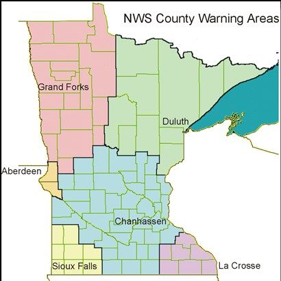
II. SERVICES PROVIDED BY THE NATIONAL WEATHER SERVICE
A. BASIC SERVICES - This section follows the National Weather Service Directive NWSI 10-401:
http://www.nws.noaa.gov/directives/sym/pd01004001curr.pdf
Local changes to the services provided in Minnesota are coordinated at the Minnesota State Fire Weather Co-
ordination Meeting held annually in December in Duluth, MN.
ROUTINE FIRE WEATHER FORECASTS ISSUED BY THE NWS
Fire Weather Planning Forecast
National Fire Danger Rating System Forecast (NFDRS)
SPOT Forecasts
Fire Weather Watches and Red Flag Warnings
Routine forecasts usually begin in March or early April and end in November or December.
User agencies will collaborate with the servicing NWS office to begin or end the text forecasts. Fire
weather forecast elements are generated daily and available on the local NWS web sites year round.
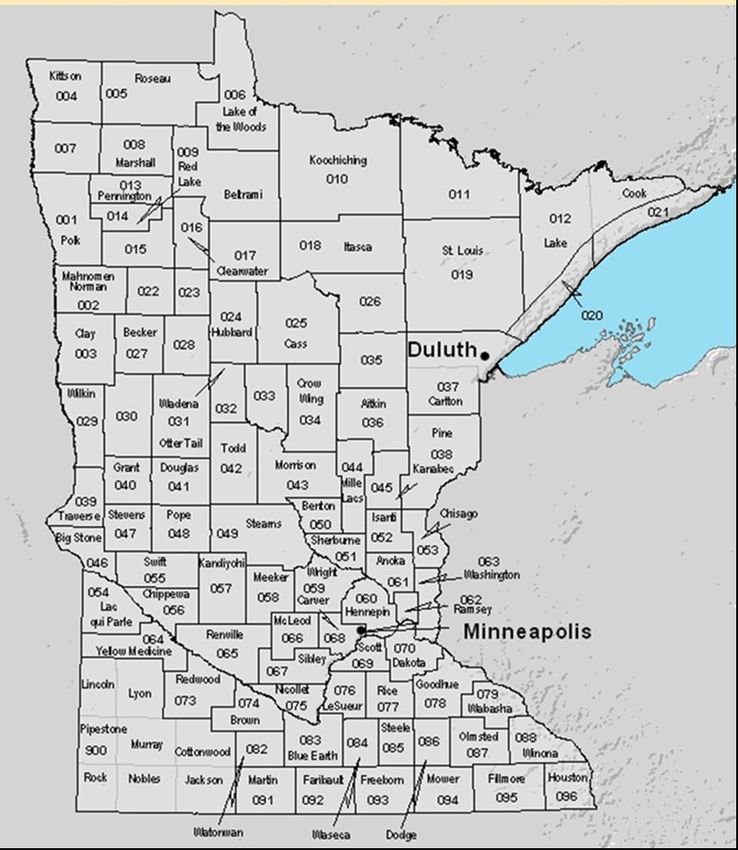
1. FIRE WEATHER PLANNING FORECAST
The Fire Weather Planning Forecast is issued for 98 fire weather zones in MN. These
zones generally follow county lines, although some of the larger counties are subdivided
into smaller zones.
This product is issued routinely twice a day
during the fire season. Once in the morning Minnesota
by 0700 and again in the afternoon by 1500 Fire Weather Zones
local time.
NWS Sioux Falls will only provide a
morning forecast issuance during the
summer months (June, July, thru mid
August), unless requested by land man-
agers to continue the afternoon prod-
uct.
This forecast will be updated when
Fire Weather Watch or Red Flag
warning has been issued/cancelled.
Current forecast is not representa-
tive of occurring or expected weath-
er conditions.
5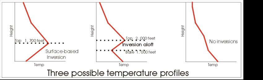
2. NFDRS POINT FORECAST (FWM)
Issued each afternoon by 1530 local time for RAWS stations in their area..
The National Fire Danger Rating System (NFDRS) is designed to represent the fire potential at the “worst time of
day” over a large area. The output from the NFDRS serves to indicate levels of fire danger. From this, resource allo-
cation and staffing are determined by the land management agencies.
If a known maintenance or data accuracy problem exists with an NFDRS forecast site, the problem will typically be
reported to the station owner by the National Interagency Fire Center (NIFC) RAWS depot via e-mail. It is the duty
of the station owner to take corrective action. If a NWS office knows of this problem and maintenance is not com-
pleted on the observation site, the NWS office may suspend the NFDRS forecast for that site until the problem is
solved. Coordination and notification of the NFDRS forecast suspension will be coordinated with the Predictive
Services section (Steve Marien) in the Eastern Area Geographic Area Coordination Center.
Point Forecast coding and interpretation
63. SPOT FORECASTS
SPOT Forecasts are site specific forecasts issued by NWS offices in support of wildfire, natural re-
source management, or public safety. The NWS will attempt to process all SPOT Forecast requests
within 20-30 minutes. These forecasts aid officials in properly planning for and protecting life and prop-
erty during wildland fires. SPOT forecasts are also issued for hazardous materials incidents, marine inci-
dents, search and rescue response and other threats to public safety.
Generally, SPOT Forecasts for prescribed burns are requested a few hours ahead of the project. They
can, however, be requested up to one day in advance with other planning tools and forecasts used for
projects planning later. An outlook forecast for a prescribed burn can be requested from Steve Marian
with the EACC. (see directory for contact info)
SPOT forecasts for a wildfire will be treated with a priority similar to that of severe weather
warnings. It is the responsibility of the requestor to indicate that the request is for wildfire suppression.
NWS offices will provide spot forecast service under the following circumstances:
Upon request of any federal, state, tribal, or local official who represents that the SPOT forecast is
required to carry out their wildland fire management responsibilities in coordination with any federal
land management agency participating in the Interagency Agreement.
Upon request of any public safety official who represents the spot forecast is essential to public safe-
ty, e.g. due to the proximity of population centers or critical infrastructure.
In support of Homeland Security Presidential Directive #5. (HSPD 5).
http://training.fema.gov/EMIWeb/IS/ICSResource/assets/HSPD-5.pdf
SPOT Content and Format –
The standard format for SPOTS includes: headlines (mandatory when Red Flag Warning or Fire Weather
Watch in effect), discussion, sky/weather, temperature, relative humidity, and 20 foot wind for 3 forecast
periods. Optional elements may also be provided. The content and number of forecast periods may be
different, as determined by the requestor. To aid in making smoke management decisions, requestors may
request Hysplit trajectory data as part of their Spot Forecast request.
If an update is made, the forecaster will call the contact number listed on the spot forecast request. Feed-
back from land management personnel is highly encouraged during or after the burn and can be submitted
via the SPOT website or by emailing the Fire Weather Focal Point (see directory for contact info).
Requesting a SPOT Procedure –
The primary way to submit a SPOT request is through the NWS SPOT REQUEST webpage of your lo-
cal NWS office.
If internet access is not available, the land manger may also call or send a fax to the local NWS office
with the appropriate information for the SPOT request.
Needed information for a SPOT request includes:
location, topography, fuel type, size, ignition time, contact info and a current weather observation.
SPOT forecasts should be considered one-time requests, and are not routinely monitored, nor updated. Land management person-
nel *must* contact the servicing NWS office for an update if conditions become unrepresentative.
7Example of a Standardized Spot Weather Forecast
Other resources for forecasts available for fire weather planning:
National Fire Weather Page: www.weather.gov/fire
Fire Weather Briefing Page: http://www.weather.gov/dlh/firebriefing
Graphical Weather Forecast: http://graphical.weather.gov/sectors/minnesota.php#tabs
3 day Outlooks: Fire Weather, Severe Weather, Rainfall: http://www.weather.gov/crh/outlooks
GACC/EACC Weather: http://gacc.nifc.gov/eacc/predictive_services/outlooks/outlooks.htm
MN IMET Resources Page: http://www.weather.gov/dlh/imet
7 Day Fronts Loop: http://www.wpc.ncep.noaa.gov/basicwx/day0-7loop.html
Severe Weather: http://www.spc.noaa.gov/
84. FIRE WEATHER WATCHES AND RED FLAG WARNINGS
NWS offices will issue Fire Weather Watches and Red Flag Warnings when the combination of dry fuels
and weather conditions support extreme fire danger and/or fire behavior. The NWS forecaster on duty
will coordinate with a representative from MNICS (see directory) prior to issuing a Fire Weather Watch
or Red Flag Warning. If a Fire Weather Watch is currently in effect, it means that weather and fuels con-
ditions have already been coordinated with land managers and no further coordination is required if a
Red Flag Warning is needed.
During situations of borderline conditions to warrant a Fire Weather Watch/Red Flag Warning, terminol-
ogy such as “CRITICAL FIRE WEATHER CONDITIONS” is strongly encouraged in NWS products.
Avoid the phrase “Red Flag” or “Extreme Fire Danger” if a Red Flag Warning is not in effect so as not to
suggest the fuels are critical when the fuels are not critical.
A Fire Weather Watch is issued when there is a reasonable confidence that conditions to warrant a
warning will be met within 18 to 72 hours. A Fire Weather Watch will NOT be issued or remain in effect
A Red Flag Warning is issued when there is a reasonable confidence that conditions to warrant a warn-
ing will be met within 48. A Red Flag Warning may span over a multiple day time period.
RED FLAG WARNING / FIRE WEATHER WATCH CRITERIA
Sustained 20 ft winds (RAWS level) of at least 20 mph or frequent gusts of at
least 25 mph.
In the Red River Valley along the western border of Minnesota and in the southwest corner of the
state sustained winds must be at or above 25 mph.
Minimum Relative Humidity (RH) of 25% or less.
Significantly dry fuels as determined by land management
Land managers may request that a Red Flag Warning be issued when all weather criteria is not ex-
pected to be met. This would include situations when fuels are critically dry or in a high wind situa-
tion when the humidity threshold may not be reached.
Other Factors
Fire Danger Rating from the MNDNR of HIGH or EXTREME.
Viewable at: http://www.dnr.state.mn.us/forestry/fire/
firerating_restrictions.html
NFDRS output provides information on several fire indices.
Viewable at: http://glffc.utah.edu/cgi-bin/gl.cgi
Generally, a BI >4 and ERC >40 imply critically dry fuels.
9Red Flag Content/Format
The Watch or Warning headline will specify:
The valid time, the area affected (by county or aerial description), and critical weather elements.
The following list of products will disseminate the Watch or Warning:
Fire Weather Planning Forecast (FWF)
The FWF will be updated if a Watch or Warning is issued at a non-scheduled forecast issuance time.
NOAA Weather Radio Following local policy.
Hazardous Weather Outlook (HWO)
Graphical Weather Story
Area Forecast Discussion (AFD).
SPOT Forecasts issued for areas in which the Watch/Warning is in effect
Social Media. The Fire Danger and issuance of a Watch or Warning may be shared on various social
media websites.
Civil Emergency Message : In the event of a large or rapidly growing wildfire that is posing a threat to
life or property, a land manger or other official may request the issuance of a Civil Emergency Message
to communicate threat of the wildfire and any evacuation orders.
Media: Land agencies will normally handle ALL media questions about fire potential and danger. The
NWS will answer questions only about weather conditions, and should not comment on fire behavior.
105. OTHER ROUTINE NWS SERVICES
Verification – The Fire weather program leader will verify the Red Flag program. Results will be distrib-
uted to the NWS Regional Fire Weather Program Managers as well as to the appropriate State and Federal
user groups in Minnesota. Red Flag Warnings will be verified based on the Probability of Detection,
False Alarm Rate, Critical Success Index, and Lead Time.
Participation in Interagency Groups - NWS offices providing fire weather services for Minnesota are
expected to participate in the Annual State Fire Meeting. This meeting serves as a forum for interaction
between NWS program leaders and their interagency users. It also provides an effective vehicle for dis-
cussions pertaining to changes to the AOP.
National Digital Forecast Database (NDFD) - The NWS provides another forecast tool called the Na-
tional Digital Forecast Database (NDFD). This database contains forecast weather parameters on a 2.5 km
grid. The NDFD runs through day 7, and is continually updated by NWS forecasters. Access to the
NDFD is possible through NWS web pages by selecting the Forecast Graphics Tab near the top of the
page. Information on the NDFD can be found at the following link: http://www.weather.gov/ndfd/
B) SPECIAL SERVICES
INCIDENT METEOROLOGIST (IMET)
The NWS provides a cadre of trained Incident Meteorologists (IMETs) who will provide on-site forecasting
for wildfires when requested by land management agencies. See directory for contact information.
Some Key Points Regarding IMETs:
Only certified Type 1 IMETS may be dispatched to support on-site service for Fire. The
NWS is responsible for maintaining proficiency of designated IMETs.
Request and dispatch of IMETs and equipment is accomplished through the National
Resource Coordination System. See directory for contact information.
In addition to wildfires, IMETs may be dispatched to support large critical resource value
prescribed burns, hazardous substance release, or any special projects/incident which fall
under the mandate of the NWS. These other events will be supported depending upon
availability.
For more information please refer to NWS Directive 10-402:
http://www.nws.noaa.gov/directives/sym/pd01004002curr.pdf
NWS IMET Google Site: https://sites.google.com/a/noaa.gov/imet/?pli=1
11C) TRAINING
1. Forecaster training
NWS forecasters producing fire weather forecasts require training as set forth in NWSI 10-405:
http://www.nws.noaa.gov/directives/sym/pd01004005curr.pdf
Complete the required NWS Fire Weather computer based learning modules and S-290,
Intermediate Wildland Fire Behavior.
Local training generally consists of review of the AOP, the Fire Weather Station Duty
Manual and other station instructions, as well as training offered by the Fire Weather
Program Leader or land management personnel.
Forecasters must be familiar with NWS fire weather products and services, as well as
be proficient in their preparation and dissemination.
All forecasters issuing SPOT Forecasts or providing phone briefings are required to
complete IS-100 and IS-700.
2. NWS Provided Training to Land Management Agencies
Guidelines for Teaching Interagency Courses:
Please refer to National Weather Service Directive NWSI 10-403 Appendix A
available at: http://www.nws.noaa.gov/directives/sym/pd01004003curr.pdf
D) NWS NOTIFICATION TO CENTRAL REGION HEADQUARTERS
In the event of a major wildfire in MN, the servicing NWS office must report it to the MIC and NWS
Central Region Headquarters (CR-ROC). A major fire event is one which results in one or more fatali-
ties, numerous injuries, major property damage, or significant media attention.
III. WILDLAND FIRE AGENCY SERVICES AND RESPONSIBILITIES
A) OPERATIONAL SUPPORT AND PREDICTIVE SERVICES
Meteorologist, Steve Marien, for the Eastern Area Coordination Center (EACC) works in a St. Paul of-
fice, while the EACC office is in Milwaukee. The EACC meteorologist combines forecast information
from NWS offices and other sources into area-wide summaries and briefings. This meteorologist,
along with Fire Intelligence, forms the Predictive Services group which produces fire weather/fire dan-
ger assessments for USFS Region 9 which includes Minnesota.
The EACC Forecasts - http://gacc.nifc.gov/eacc/predictive_services/weather/weather.htm
Steve Marien, EACC Meteorologist — Stephen_Marien@nps.gov
Please see the directory in the Appendix for addresses and contact information.
12B) AGENCY COMPUTER SYSTEMS
The communication system used to link the NWS with its users is the Weather Information and Manage-
ment System (WIMS). The NWS receives user agency observations entered into WIMS via its Advanced
Weather Interactive Processing System (AWIPS) computer system. Point and narrative forecasts are also
sent to WIMS via this system. Observations and forecasts are exchanged between WIMS and AWIPS in
the USFS Kansas City Computer Center.
C) FIRE WEATHER OBSERVATIONS AND STATIONS
All fire weather observations in Minnesota are from automated sites, and all have GOES antennas installed
for data transmission. Station inspection and instrument maintenance are the responsibility of land man-
agement agencies. See Figures 9 and 10.
If a land management agency requests that NWS personnel assist in setting up a RAWS station, the NWS
will oblige per the National Agreement. NWS travel expenses for equipment maintenance or station visits
will be reimbursed by the Wild Land Fire Agency making the request. The NWS Fire Weather Program
Leader and EACC Meteorologist need to be informed of any requests for new RAWS stations.
The NWS is responsible for assigning station numbers to NFDRS weather sites. The NWS local Fire
Weather Program Leader will coordinate with the appropriate land management personnel and WIMS staff
to determine the 6-digit station ID. It is the responsibility of the requestor/land management personnel to
notify WIMS staff of RAWS station status.
Available Sites to View Fire Weather Observations and Locations:
Great Lakes Fire and Fuels Page: http://glff.mesowest.org
Western Regional Climate Center: http://www.wrcc.dri.edu/wraws/mnF.html
National Centers
National Fire Weather Page: http://weather.gov/fire/
US National Interagency Fire Center: http://www.nifc.gov
Eastern Area Coordination Center: http://gacc.nifc.gov/eacc/
D) REIMBURSEMENT FOR NWS PROVIDED ON-SITE SUPPORT AND TRAINING
Agencies will reimburse the NWS for all costs incurred for IMET support as well as for training assistance
or station visitation.
13IV. JOINT RESPONSIBILITIES
TRAINING
Meteorological training can be provided either by the NWS or the EACC meteorologist. Each NWS of-
fice has at least one person, typically the Fire Weather Program Leader, who is qualified to teach courses
at least through Intermediate Fire Behavior (S-290). Requests for NWS training should be directed to
that office’s Fire Weather Program Leader or MIC. Sufficient notice should be given to allow for prepara-
tion as well as scheduling. Costs incurred by the NWS will be reimbursed by the requesting agency.
COORDINATION CALLS AND WEBINARS
NWS Fire Weather Program Leaders will participate in MNICS-hosted coordination conference calls.
This duty will be shared by the program leaders. If they are not available, the EACC meteorologist or an-
other forecaster on duty may fill in to conduct the weather briefing.
Calls are typically scheduled at 0900 on Tuesdays and Fridays during the fire season. The weather portion
of the briefing should focus on the state of MN and be no more than 5 min. The weather briefing will
highlight the forecast for the next 2-3 days, as well as any significant weather trends or possible critical
fire weather situations in the upcoming week. Forecasters are asked present weather information in a
day-to-day format, rather than element-to-element.
The Web Ex Conference call is hosted by MNICS on Tuesdays and Fridays during the fire season. A fire
weather briefing page is maintained at the Duluth NWS and can be viewed at
http://www.weather.gov/dlh/firebriefing
V. EFFECTIVE DATES ON THE AOP
This document will be effective approximately from February 1st, 2018 to February 1st, 2019.
VI. AGENCY SIGNATURES
Michael Stewart, MIC NWS Duluth_____________________________________________ /Signed/date
Representing all NWS offices with fire weather forecast responsibility in Minnesota
Seth Grimm, USFWS, MNICS Task Force Chairman _________________________________/Signed/date
Signing for MN DNR and All Federal Land Managers
Management Agencies: USFS, BIA, NPS, USFWS
142018 Minnesota Fire Weather
Annual Operating Plan
VII. Appendix
A. Smoke Management
B. Haines Index
C. NOAA Weather Radio Network
D. Fire-Weather Personal Directory (non-web version only)
15APPENDIX A - SMOKE MANAGEMENT
The Clean Air Act requires land management agencies to address the issue of smoke management in its pre-
scribed burns. The goal is to burn in atmospheric conditions that would encourage smoke to rise to such a lev-
el that the smoke is dispersed as much as possible to reduce a number of health and safety risks near the fire.
A Minnesota Smoke Management Plan (SMP) was created in the year 2000 and should be considered the
source document for any questions regarding the requirements or practices of smoke management in Minneso-
ta. The Plan was updated in 2014.
The National Weather Service will support the smoke management efforts of federal, state, and local agencies
as well as organizations involved in such burning. The NWS will provide three (3) parameters used in smoke
management in its Fire Weather Planning Forecasts. The NWS will also include these parameters, upon re-
quest of the land agency, in spot forecasts.
The three weather parameters of smoke management forecasts are mixing layer (or depth), transport winds,
and dispersion index. For smoke management purposes, the mixing layer is usually considered the lowest lay-
ers of the atmosphere bounded by the earth’s surface and the bottom of any temperature inversion which may
exist aloft. A temperature inversion serves to trap smoke at low levels and prevents sufficient lofting of smoke
to a level where winds would dilute or transport it away from the area.
Figure 16. Three upper air temperature profiles which affect smoke dispersal differently.
1) a surface-based inversion is an absolutely stable condition that traps smoke and prevents lofting.
2) An elevated inversion is unstable or neutral and allows limited smoke rise, but the smoke will stop rising at
the base of the inversion aloft.
3) When no inversions are present, smoke is free to rise. However, the existing (ambient) lapse rate will deter-
mine the rate of rise and the plume characteristics.
The transport wind is defined as the average wind speed and direction through the mixing layer.
In forecasts provided by the NWS, the transport wind will be provided in mph and the height of the mixed lay-
er will be in feet AGL (above ground level).
The Dispersion Index is detailed in the Minnesota Smoke Management Plan (SMP) in section 4.2.2. The index
is intended to serve as a single adjective index which describes how smoke will disperse on that day. The Dis-
persion Rate is given by the following formula as defined in the Minnesota Smoke Management Plan:
Dispersion Index = (Mixing Height in feet) x (Transport Wind in knots)
The Minnesota Smoke Management Plan (SMP) suggests the following interpretation of the values:
Dispersion Index Dispersion Rate
< 13,000 Poor
13,000 - 29,999 Fair
30,000 - 59,999 Good
60,000 or greater Excellent
16APPENDIX B - HAINES
What is the Haines Index?
The Haines Index combines the effects of dry air and instability to determine the potential for fire growth. Its
purpose is to identify weather conditions that may allow an existing fire to spread rapidly or exhibit extreme
fire behavior. The Haines Index does not account for wind. Instability is caused by warming the lower levels
of the atmosphere, cooling the higher levels, or by a combination of the two processes. An unstable air mass
promotes convection and rising currents of air.
In Minnesota, we use the mid-level layer of the atmosphere to calculate the Haines Index.
(850 mb = around 5000 feet. 700 mb = ~9000 feet agl).
Computing the Haines Index
Haines Index = Stability (A) + Moisture (B)
Stability Term (A) = 850 mb Temperature - 700 mb Temperature
Let A equal the following values according to the temperature differences
When stability term is 5 degrees C or less, let A = 1
When stability term is 6 to 10 degrees C, let A = 2
When stability term is 11 degrees C or more, let A =3
Moisture Term (B) = 850 mb Temperature - 850 mb Dew Point
When moisture term is 5 degrees C or less, let B = 1
When moisture term is 6 to 12 degrees C, let B = 2
When moisture term is 13 degrees C or more, let B = 3
(The greater the value of this term, the drier the air is).
Haines = A + B Haines Values
2 or 3 Very Low
4 Low
5 Moderate
6 High
A weakness of using the Haines Index is that the stability and moisture terms are calculated at two fixed levels
(850 and 700 MB). At times, making the calculations at slightly different levels could lead to a significantly
different Haines Index.
17APPENDIX C - NOAA Weather Radio Stations
For more information about each transmitter site, and a complete listing of frequencies please visit:
http://www.nws.noaa.gov/nwr/Maps/PHP/MN.php
18You can also read