Scope & Sequence 2019-2020 - 8th Grade Social Studies Louisiana's Identity: This is Louisiana - Jefferson Parish School Board
←
→
Page content transcription
If your browser does not render page correctly, please read the page content below
8 Grade Social Studies
  th

      2019-2020
   Scope & Sequence
               Unit 1
Louisiana’s Identity: This is Louisiana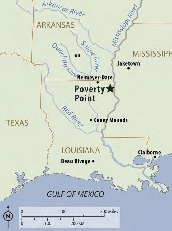
Notes & How to Use this Document
This document is intended to replace the Louisiana Department of Education Scope &
Sequence for Jefferson Parish Schools’ 8th Grade Social Studies course. Please use this in
conjunction with the JPS Curriculum Map and LDOE Companion Document, both of which
have been incorporated into this scope and sequence. This document goes with the 2019-
2020 Student Resource Book. There is also the Louisiana History Workbook (1 book per
unit per student except Unit 1-2 is in 1 book).

This Scope and Sequence guides your teaching with pacing, priority content information
and a sample of activities to support and extend learning. As you deliver initial instruction,
you may choose to implement the activities found here (Student Version is the Student
Resource Book) and/or use your own activities. The activities found in this
document/student version DO NOT cover every GLE in the priority content. Anything in
black in this document is what students see in their books (1 per unit).

Imperative to any instruction is teaching the grade level expectations with fidelity.

As stated in the Louisiana Scope and Sequence Documents:

To be productive members of society, students must be critical consumers of information
they read, hear, and observe and communicate effectively about their ideas. They need to
gain knowledge from a wide array of sources and examine and evaluate that information to
develop and express an informed opinion, using information gained from the sources and
their background knowledge. Students must also make connections between what they
learn about the past and the present to understand how and why events happen and people
act in certain ways.

To accomplish this, students must:

   1. Use sources regularly to learn content.
   2. Make connections among people, events, and ideas across time and place.
   3. Express informed opinions using evidence from sources and outside knowledge.

Teachers must create instructional opportunities that delve deeply into content and guide
students in developing and supporting claims about social studies concepts.

For access to all documents, additional resources and the 6-12 social studies community
of Jefferson Parish Schools, please join the Google Classroom- JP Social Studies Teachers
6-12 (class code: axsa5q).
8th Grade Social Studies Curriculum Map
2019-2020
**NOTE: The topics, Louisiana’s Natural Resources and Coastal Erosion, should be taught in Unit 6
and not in Unit 1 as it was instructed in previous years. Unit 1 includes Native American Settlement,
European Exploration and Settlement and Louisiana’s Cultural Geography.** --Changes are
italicized in green**
1st 9 Weeks (August 8- October 9)/2nd9 Weeks (October 14- December
20)
UNIT DATES ASSESSMENTS DBQs
Aug. 12-16 District
Diagnostic
1- Louisiana’s Identity: This 21 Days District/Teacher-
Aug. 8-Sept. created that mimics
is Louisiana 6 the LEAP 2025
Topics: Essential
Native American Settlement GLEs:
European Exploration & 8.2.1-5
Settlement 8.4.1-2
Louisiana’s Cultural
Geography
2- Louisiana: Settlement & 22 Days District/Teacher-
Sept. 9-Oct. created that mimics
Colonial Legacy 9 the LEAP 2025
Topics: Essential
Louisiana Purchase GLEs:
Statehood & the Battle of 8.2.2-3,5
New Orleans 8.3.1—2
8.4.1-2
8.6.1-2
8.7.1-2
Oct. 7-9 District
Benchmark 1
3- 19th Century Louisiana: A 42 Days District/Teacher- What caused the
Oct. 14-Dec. created that mimics Civil War?
State in Conflict 18 the LEAP 2025 ~OR~
Topics: Essential North or South:
Antebellum Period GLEs: Who killed
Civil War in Louisiana 8.2.2, 5-6 Reconstruction?
Reconstruction 8.4.3
8.6.1-2
8.7.1-2
8.8.1
8.9.3
8.10.3
Dec. 16-18 District
Benchmark 2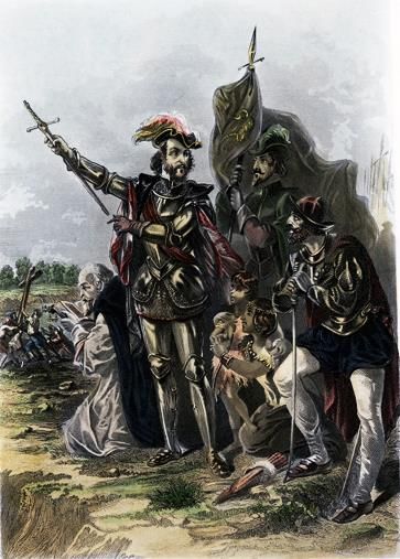
3rd 9 Weeks (January 7- March 12)/ 4th 9 Weeks (March 16-May 21)
UNIT DATES ASSESSMENTS DBQs
4- Louisiana: An Identity in 18 Days District/Teacher-
Jan. 7-31 created that mimics
Transition the LEAP 2025
Topics: Essential
Jim Crow GLEs:
Populism & the Flood of 8.2.5, 7
1927 8.4.3
Huey Long 8.5.1-2
8.6.1
8.7.1
8.8.1
8.10.1-4
5- 20th Century Louisiana: A 15 Days District/Teacher- Politics or
Feb. 3-21 created that mimics Principle: Why did
Changing Identity the LEAP 2025 LBJ sign the Civil
Topics: Essential Rights Act of 1964?
World War II GLEs:
Civil Rights 8.2.5, 8-9
8.6.1-2
8.7.1-2
8.8.1-2
8.9.2-3
8.10.1-2, 3
6- Louisiana’s Identity: A 24 Days District/Teacher-
March 2-27 created that mimics
Modern State the LEAP 2025
Topics: Essential
Louisiana’s Government GLEs:
Louisiana’s Economy 8.2.2, 5
Louisiana’s Natural 8.5.1-2
Resources 8.6.1, 3
Coastal Erosion 8.7.2
8.8.1-2
8.9.1-3
8.10.3
March 9-12 District
Benchmark 3
March 30- LEAP 2025
May 1
Extension Activities & Through the
Projects end of the
Semester
CATEGORY STANDARDS APPROXIMATE % POINTS ON LEAP
2025
History 1-2 55
Geography 3-5 15
Civics 6-8 15
Economics 9-10 15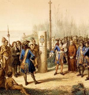
Unit One
      Louisiana’s Identity:
       This is Louisiana
Description
You will learn how European settlement and colonization of Louisiana has shaped
Louisiana’s identity and effected its multicultural society.

Claim
What is the legacy of settlement and colonization on an area's identity?

Key Connections
● Geographic features and resources affected migration and settlement patterns.
● Physical geography influenced the politics, economy, society, and culture of
  Louisiana.
● Migration and settlement patterns shaped the development of Louisiana.
● People, ideas, and events contributed to the social, political, economic, and cultural
  development of Louisiana.
● Similarities and differences among groups contributed to cooperation and conflict.

Topics
One- Native American Settlement
Two- European Exploration and Settlement
Three-Louisiana’s Cultural Geography
Unit 1 Essential Content
Grade-Level Expectations (GLEs)                        Priority Content and Concepts

8.2.1 Describe the contributions of   ● Describe the features and characteristics of settlements by
explorers and early settlement          historic Native American groups in Louisiana (location,
groups to the development of            earthworks/mounds/ridges, agricultural practices, economy
Louisiana                               and trade, systems of organization and government, social
                                        structures, religious and cultural practices).
                                      ● Analyze the contributions of historic Native American
                                        groups to the development of Louisiana (Poverty Point as a
                                        cultural capital for the region, advanced early civilization,
                                        and center of trading network).
                                      ● Explain the significance of early European exploration to
                                        the history of Louisiana (discoveries, founding of
                                        settlements, interactions among groups).
                                      ● Describe the contributions early settlement groups made to
                                        Louisiana (French, Spanish, Africans, Acadians, Germans,
                                        Canary Islanders/Islenos, Haitians), and explain how those
                                        contributions influenced the development of Louisiana.
                                      ● Compare and contrast French and Spanish colonial Louisiana,
                                        including political, economic, social, and cultural factors.
                                      ● Analyze the successes and failures of the French and
                                        Spanish in Louisiana, and evaluate which group had greater
                                        success in the development of colonial Louisiana.
8.2.2 Explain the importance of the   ● Analyze the role and importance of the Mississippi River in the
Mississippi River as it relates to      development of Native American settlements (trading,
historical events throughout            transportation).
Louisiana’s history                   ● Analyze the importance of the Mississippi River to
                                        European exploration and settlement of colonial
                                        Louisiana (transportation, agriculture, trading).
                                      ● Analyze how the Mississippi River affected the economy of
                                        Louisiana during pre-colonial and colonial times.
8.2.3 Analyze push-pull factors for   ● Explain motivations for European exploration of Louisiana and
migration/settlement patterns of        surrounding territory (expand trade networks and markets,
Louisiana’s inhabitants from French     gain access to land and resources, expand empire, spread
colonization to statehood in 1812       religious and cultural values).
                                      ● Analyze push and pull factors for migration to and settlement
                                        in colonial Louisiana for different groups.
                                      ● Explain the significance of the forced migration of enslaved
                                        people to colonial Louisiana.
8.2.4 Explain how differences and     ● Describe interactions among groups in pre-colonial and
similarities among ethnic groups in     colonial Louisiana (Native American groups and Europeans,
colonial Louisiana contributed to       European settlement groups with one another, enslaved
cooperation and conflict                people with other groups), and provide examples of
                                        cooperation and conflict among groups.
                                      ● Analyze causes and effects of interactions among groups in
                                        pre-colonial and colonial Louisiana (trade, land and
                                        resources, treaties, conflict/war).
                                      ● Explain the importance of trade between Native
Americans and the French and the trading relationship
                                            between the two groups.
                                          ● Explain the origins and effects of the Code Noir in French
                                            Louisiana.

8.2.5 Analyze causes and effects of       ● Discuss the causes and outcomes of the French and Indian
major events and evaluate their             War, and explain how the conflict influenced the
impact on the growth and                    development of Louisiana (transfer of Louisiana from
development of Louisiana                    France to Spain).

8.4.1 Analyze how the physical            ● Explain the role physical geography played in the location
features and natural resources of           of Native American settlements in Louisiana.
Louisiana affected the migration          ● Analyze the influence of Louisiana’s physical features
patterns of cultural groups                 and natural resources in motivating European
                                            explorations into the area.
                                          ● Explain how the physical features and natural resources
                                            in Louisiana influenced settlement patterns.
8.4.2 Describe the causes and             ● Explain the ways Native American groups and early settlers
effects of cultural diffusion and its       influenced one another’s culture and the development of
impact on diversity in early                Louisiana’s culture (language, religion, art forms, food, other
Louisiana                                   cultural traditions).
                                          ● Describe the influence of different groups on the cultural
                                            diversity of pre-colonial and colonial Louisiana.

                                Unit 1 Ancillary Content
8.1.1 Produce clear and coherent              Opportunities for addressing 8.1.1 in this unit:
writing for a range of tasks, purposes,        ● Conduct historical research on the settlement
and audiences by:                                patterns and contributions of early settlement groups
    ● Conducting historical research             in Louisiana.
    ● Evaluating a broad variety of            ● Analyze artifacts to determine the characteristics of historic
         primary and secondary                   Native American groups in Louisiana.
         sources                               ● Evaluate primary sources from the age of exploration
    ● Determining the meaning of                 (journals, paintings, carvings) to answer questions about
         words and phrases from                  the perceptions and motivations of European explorers
         historical texts                        and Native Americans in Louisiana.
    ● Recognizing varied points of             ● Analyze Le Code Noir to answer questions about early
         view within historical context          settlers in Louisiana.
8.1.2 Construct and interpret a timeline       ● Create and/or interpret a timeline of events to answer
of key events in Louisiana history and           questions about the exploration of pre- colonial
describe how they connect to United              Louisiana by European explorers.
States and world events                        ● Construct and/or interpret a timeline of events to
                                                 answer questions about Acadian exile and
                                                 resettlement.
                                               ● Construct and/or interpret a timeline of political,
                                                 economic, and social events in French and Spanish
                                                 colonial Louisiana.
8.3.1 Locate and describe the ● Use maps to locate important physical and
physical and political features of political features in pre-colonial and colonial
Louisiana Louisiana.
● Analyze maps to answer questions about European land
claims in North America.
8.3.2 Use maps, charts, and diagrams to ● Explain the role physical geography plays in the location
ask and answer questions about of major settlements in pre-colonial and colonial
Louisiana’s geographic features Louisiana.
8.3.3 Apply knowledge of geography ● Analyze maps and diagrams related to pre-colonial and
skills and terms to: colonial Louisiana.
● create maps and diagrams ● Plot coordinates of latitude and longitude for locations in
● plot latitude and pre-colonial and colonial Louisiana.
longitudinal ● Read and interpret different types of maps
coordinates (authentic and reproductions of historical maps
● read and interpret a map showing exploration routes, city plans, major
● use a map to compare settlement areas).
Louisiana’s time zone in
relation to time zones around
the world
8.7.1 Explain how the United States ● Explain how the economic theory of mercantilism
and world foreign policy have motivated European exploration in Louisiana.
affected Louisiana
8.10.1 Analyze how scarcity of ● Describe the effects of scarcity on relationships between
resources affects the choices of Europeans and Native Americans.
individuals and communities
8.10.2 Explain choice/trade-offs, ● Apply the concepts of choice/trade-offs,
cost/benefits, and opportunity costs cost/benefits, and opportunity costs to economic
related to making personal economic decisions made by European explorers,
decisions government officials, and settlement groups.
8.10.3 Describe historical factors ● Describe the importance of the development of
influencing the economic growth, the Port of New Orleans on the Louisiana economy
interdependence, and development over time.
of LouisianaKey Terms Antoine Simon Le Page du Pratz Fort Louis Hernando de Soto Mobile Bay Sarah McIlhenny Fort St. Jean Pierre Le Moyne Baptiste (Natchitoches) Sieur d’Iberville Poste du Rapides (Alexandria) Jean-Baptiste Le Moyne artifact Sieur de Bienville prehistoric Alonso Álvarez de Pineda archaeologist Sieur de Sauvole midden Antoine Crozat nomadic Antoine de la Mothe atlatl Sieur de Cadillac mound Louis Juchereau de St. Denis agriculture John Law maize Étienne de Périer immunity Pierre François de Rigaud tribe Marquis de Vaudreuil treaty Louis Billouart mouth Chevalier de Kerlerec commandant Poverty Point commissary-commissioner New Orleans proprietorship Charenton indigo Zwolle calumet Angola joint-stock company Kinder Mississippi Bubble Fort St. Louis Concession Matagorda Bay casket girls Ship Island Code Noir Fort Maurepas French and Indian War English Turn Treaty of Paris Fort Mississippi
Topic One
              Native American Settlement
                       (8.1.1, 8.2.1, 8.2.2, 8.3.3, 8.4.1)

Connections to the Unit Claim
You will examine the economic, historical, and cultural legacy left by the Native
Americans of Poverty Point.

To Explore These Key Questions
●   How did the Mississippi River help Poverty Point flourish economically and
    culturally?
●   What is the legacy of Native American settlement on Louisiana’s identity?
Instructional Task One:
Poverty Point
You will examine how Poverty Point was built by hunter gatherers and how it flourished as a culture and
economic center in north Louisiana because it proximity to the Mississippi River.
Instructional Process:
1. Say “In this unit we will focus on specific historic and prehistoric periods in Louisiana to
investigate the legacy of settlement on an area's identity. We will begin by exploring prehistoric,
the time before writing, settlements by investigating the Poverty Point Culture located in North
Louisiana.”
2. Project a copy of the Location Map of Poverty Point (Student Resource Book).
3. Conduct a brief discussion about the role physical geography played in the location of Poverty
Point. Possible questions (Student Resource Book):
1. What makes Poverty Point’s location important?
2. Why do you believe Poverty Point was located adjacent to the Mississippi River?
3. Based on your knowledge of how physical geography shapes an area’s cultural geography,
what do you believe was the basis for Poverty Point’s economy?
4. Say “As we further research Poverty Point we will be able to see if your predictions about Poverty
Point were correct.”
5. Provide students with a copy of the Mystery in Louisiana-Poverty Point Evidence Chart (Student
Resource Book).
6. View Mystery in Louisiana -Poverty Point (entire class).
7. Have students use their Mystery in Louisiana-Poverty Point Evidence Chart to support the claim
that Poverty Point was a complex society.
8. Conduct a discussion about how a hunter-gatherer society could build a permanent city as large
as Poverty Point. Encourage students to use the conversation stems (JPS 6-12 Social Studies
Google Classroom- print and give to students to keep in notbook/binder) during the discussion
and provide evidence from the video Mystery in Louisiana -Poverty Point to support their
answers. Possible questions (Student Resource Book):
1. What is a hunter-gatherer?
2. Why were most hunter-gatherers not able to settle in cities?
3. Why are hunter-gatherer societies usually not considered complex?
4. What makes Poverty Point different from most hunter-gatherer societies?
5. How do we know Mound A only took 30 - 90 days to build?
6. Native Americans at Poverty Point did not have a writing system, how do archaeologists know
so much about Poverty Point?
7. Would you consider Poverty Point culture a complex society? Why or Why not?
9. After the discussion say “Poverty Point’s placement next to the Mississippi River made it an ideal
location for trade and commerce which enabled the city to survive and thrive. We will now
examine what made Poverty Point a marvel of the ancient world.”10. As the students watch the following video, have them locate evidence that supports the author's
claim on the Origins of Cities: Poverty Point Evidence Chart (Student Resource Book).
11. Project Origins of Cities - Poverty Point and view as a class to give students an overview of the
legacy left behind by Poverty Point.
12. Conduct a brief discussion about Poverty Point being a major Native American trading center.
Possible questions (Student Resource Book):
1. Why do most societies need agriculture to settle into urban societies?
2. Why did Poverty Point Native Americans not need agriculture to survive as an urban center?
3. How do archaeologists know Poverty Point was a major trade center?
4. What aspect of Poverty Point’s location make it ideal for a trade center?
13. Divide the class into three groups using an established classroom routine OR have students
complete independently.
14. Set up three stations around the room: Geographic/Historical Characteristics of Poverty Point,
Cultural Characteristics of Poverty Point, and Economic Characteristics of Poverty Point.
15. At each station place one of the following documents:
1. Geographic/Historical Characteristics (Station 1)
2. Cultural Characteristics (Station 2)
3. Economic Characteristics (Station 3)
16. Direct students to read each set of documents as a group and discuss how each characteristics
has shaped Poverty Point’s identity. Direct students to locate and record evidence in the
documents that supports the claim about Poverty Point’s identity using their Aspects of Poverty
Point’s Identity graphic organizer (Student Resource Book). Rotate groups from station to station.
17. Conduct a discussion about the cultural, economic, historical, and geographical legacy of Poverty
Point. Encourage students to use the conversation stems during the discussion and provide
evidence from their handout, Aspects of Poverty Point’s Identity Graphic Organizer and outside
knowledge to support their answers. Possible questions (Student Resource Book):
1. How do archaeologists know the legacy of Poverty Point?
2. What do you believe the earthworks at Poverty Point were intended to be used for? What
evidence allowed you to come to that conclusion?
3. Explain how Poverty Point was able to have a complex culture while not being able to grow
their own crops.
4. How did the area’s physical geography affect Poverty Point?
5. How was the Mississippi River an important aspect of daily life at Poverty Point?
6. How did Poverty Point’s physical geography affect its cultural geography?
7. If you were a Native American living at Poverty Point, what are some ways you would get food
to survive?
8. How did Poverty Point shape Louisiana’s identity?
9. From the information you gathered about Poverty Point, why will Europeans desire to
colonize Louisiana in the 17th Century?Directions:
Examine the map and answer the questions.
Location of Poverty Point
This work from the Louisiana Department of Culture, Recreation & Tourism is used with permission.
The original work is available at
http://www.crt.state.la.us/dataprojects/archaeology/povertypoint/assets/poverty-point-pdf-1.03.pdf.1. What makes Poverty Point’s location important?
___________________________________________________________________
___________________________________________________________________
___________________________________________________________________
___________________________________________________________________
2. Why do you believe Poverty Point was located adjacent to the Mississippi River?
___________________________________________________________________
___________________________________________________________________
___________________________________________________________________
___________________________________________________________________
3. Based on your knowledge of how physical geography shapes an area’s cultural
geography, what do you believe was the basis for Poverty Point’s economy?
___________________________________________________________________
___________________________________________________________________
___________________________________________________________________
___________________________________________________________________Directions:
Complete the Evidence Chart after watching the video “Mystery in Louisiana: Poverty
Point”.
Mystery in Louisiana: Poverty Point - Evidence Chart
Claim:
___________________________________________________________________________________
Evidence How does this evidence support the claim?Mystery in Louisiana: Poverty Point - Evidence Chart (Completed)
Claim: The people who lived at Poverty Point were far more complex than previously thought.
Evidence How does this evidence support the claim?
Native Americans at Poverty Point built massive This supports the claim that Poverty Point was more
earthworks in a very short time frame. complex than previously thought because building
massive earthworks in a short time frame show that
over 1,000 Native Americans worked in an organized
way to build these mounds in less than 90 days.
Native Americans build massive earthworks and This supports the claim that Poverty Point was more
used the earthworks as places of worship. complex than previously thought because complex
societies have organized religions and build temples
in the center of their civilizations for worship.
Poverty Point had an organized control system This supports the claim that Poverty Point was more
which could organize the work of thousands of complex than previously thought because having an
citizens to build the city’s earthworks and buildings. organized government which maintains order and
control is necessary to have an advanced civilization.
Poverty Point had a unique social organization, This supports the claim that Poverty Point was more
economy, religion, politics, and worldview. complex than previously thought because even
though Poverty Point was built by hunter-gatherers
they had all the qualities of a complex settled
civilization.Directions: Answer the following questions after watching the video “Mystery in Louisiana: Poverty Point”. 1. What is a hunter-gatherer? ___________________________________________________________________ ___________________________________________________________________ ___________________________________________________________________ ___________________________________________________________________ 2. Why were most hunter-gatherers not able to settle in cities? ___________________________________________________________________ ___________________________________________________________________ ___________________________________________________________________ ___________________________________________________________________ 3. Why are hunter-gatherer societies usually not considered complex? ___________________________________________________________________ ___________________________________________________________________ ___________________________________________________________________ ___________________________________________________________________ 4. What makes Poverty Point different from most hunter-gatherer societies? ___________________________________________________________________ ___________________________________________________________________ ___________________________________________________________________ ___________________________________________________________________ 5. How do we know Mound A only took 30 - 90 days to build? ___________________________________________________________________ ___________________________________________________________________ ___________________________________________________________________ ___________________________________________________________________
6. Native Americans at Poverty Point did not have a writing system, how do
   archaeologists know so much about Poverty Point?
    ___________________________________________________________________
   ___________________________________________________________________
   ___________________________________________________________________
   ___________________________________________________________________

7. Would you consider Poverty Point culture a complex society? Why or Why not?
   ___________________________________________________________________
   ___________________________________________________________________
   ___________________________________________________________________
   ___________________________________________________________________
Directions:
Complete the chart after watching the video “Origins of Cities: Poverty Point.”
Origins of Cities: Poverty Point - Evidence Chart
Claim: Poverty Point was a major Native American Trading Center
Evidence How does this evidence support the claim?Origins of Cities: Poverty Point - Evidence Chart (Completed)
Claim: Poverty Point was a major Native American Trading Center
Evidence How does this evidence support the claim?
Poverty Point was built by a hunter-gatherer This provides evidence that Poverty Point was a trading
society. center because the only way Native Americans in
Poverty Point could acquire enough food to survive and
thrive was by trading with other Native Americans.
Native Americans who built Poverty Point placed This provides evidence that Poverty Point was a trading
a major plaza at the middle of the city for center because having a plaza gave Native Americans
trading. an area to congregate and trade with each other.
Archaeologists have found copper, mica, and This provides evidence that Poverty Point was a trading
steatite at Poverty Point. These materials are center because these objects were found at Poverty
not naturally found in Louisiana and originated Point and were brought by traders down the Mississippi
from places thousands of miles away. River and its tributaries to Poverty Point for trading
purposes.
Poverty Point was located on the Mississippi This provides evidence that Poverty Point was a trading
River. center because water transportation was the fastest
form of transportation at the time. Therefore, Poverty
Point’s location was ideal for a trading center.Directions:
Answer the following questions after watching the video “Origins of Cities: Poverty
Point.”
1. Why do most societies need agriculture to settle into urban societies?
___________________________________________________________________
___________________________________________________________________
___________________________________________________________________
___________________________________________________________________
2. Why did Poverty Point Native Americans not need agriculture to survive as an urban
center?
___________________________________________________________________
___________________________________________________________________
___________________________________________________________________
___________________________________________________________________
3. How do archaeologists know Poverty Point was a major trade center?
___________________________________________________________________
___________________________________________________________________
___________________________________________________________________
___________________________________________________________________
4. What aspect of Poverty Point’s location make it ideal for a trade center?
___________________________________________________________________
___________________________________________________________________
___________________________________________________________________
___________________________________________________________________Directions:
Working with your group, complete the chart after reading the information on Poverty
Point.
Aspects of Poverty Point’s Identity Graphic Organizer
Poverty Point’s Identity:
Poverty Point was an advanced civilization even though it was created by hunter-gatherers.
Geographic/Historical
Cultural Characteristics Economic Characteristics
CharacteristicsAspects of Poverty Point’s Identity Graphic Organizer (Completed)
Poverty Point’s Identity: Poverty Point was an advanced civilization even though it was created by
hunter-gatherers.
Geographic/Historical
Cultural Characteristics Economic Characteristics
Characteristics
● Poverty Point was the cultural ● Poverty Point was the center of a ● Poverty Point was built by
capital for this region of North huge trading network. Native Americans between
America. ● Poverty Point was built around 1700 B.C. and 1100 B.C.
● Archaeologists believe the many rivers but the natural ridge ● Poverty Point has the largest
mounds of Poverty Point could it was built on was not earthworks in the Western
have been used for susceptible to flooding. Hemisphere.
ceremonies because they have ● Rivers were the main ● Some Archaeologists believe
found remains of fire pits and transportation routes for Native it was North America’s first
postholes on the mounds. Americans. city.
● Archaeologists have found ● Archaeologists know Native ● Native Americans at Poverty
figurines shaped like people Americans traded at Poverty Point did not grow food or
which could be used to honor Point because they have found raise animals. They survived
ancestors, or for religious rocks at Poverty Point which are and thrived as a hunter-
purposes. not from Louisiana. gatherer society.
● Late Archaic Native Americans ● These rocks originated from ● Poverty Point was located
were hunter-gatherers who many different areas around next to the Mississippi River
usually never settled in big central North America. for trade purposes.
groups. Poverty Point is an ● The plaza at the center of Poverty ● Poverty Point was built
exception to this because it Point probably served as a during the late Archaic
was a major city built during meeting place for business. Period.
this period. ● Poverty Point had a dock so boats ● Poverty Point had abundant
● Poverty Point required a lot of could stop and trade in the plaza. food resources because of
work to build which shows nearby wetlands, woods, and
families could have lived there rivers. Native Americans
for generations. could also trade for food at
● Poverty Point Native Poverty Point.
Americans wore gorgets or ● Archaeologists have found
ornaments which is evidence bones of many animals
they had an advanced culture. including deer, fish, squirrel,
● Archaeologists have found and turtles. This proves
beads from Poverty Point at residents of Poverty Point ate
other Native American sites in a variety of animals to survive
Louisiana which shows and that they were skilled
Poverty Point had a strong hunters and fishers.
cultural influence on the
surrounding areas.
● Archaeologists have recovered
pipes made of clay and stone
which could have been used
for religious rituals or
ceremonies
● Archaeologists have found
shards of pottery showing
Poverty Point Native
Americans used pottery for
everyday life.Geographic/Historical Characteristics
This work from the Louisiana Department of Culture, Recreation & Tourism is used with permission.
                                  The original work is available at
http://www.crt.state.la.us/dataprojects/archaeology/povertypoint/assets/poverty-point-pdf-1.03.pdf.
Cultural Characteristics of Poverty Point
This work from the Louisiana Department of Culture, Recreation & Tourism is used with permission. The original work is
  available at http://www.crt.state.la.us/dataprojects/archaeology/povertypoint/assets/poverty-point-pdf-1.03.pdf.
Economic Characteristics of Poverty Point
This work from the Louisiana Department of Culture, Recreation & Tourism is used with permission.
                                  The original work is available at
http://www.crt.state.la.us/dataprojects/archaeology/povertypoint/assets/poverty-point-pdf-1.03.pdf.
Directions:
Answer the following questions after completing graphic organizer on Poverty Point.
10.How do archaeologists know the legacy of Poverty Point?
___________________________________________________________________
___________________________________________________________________
___________________________________________________________________
___________________________________________________________________
11.What do you believe the earthworks at Poverty Point were intended to be used for?
What evidence allowed you to come to that conclusion?
___________________________________________________________________
___________________________________________________________________
___________________________________________________________________
___________________________________________________________________
12.Explain how Poverty Point was able to have a complex culture while not being able
to grow their own crops.
___________________________________________________________________
___________________________________________________________________
___________________________________________________________________
___________________________________________________________________
13.How did the area’s physical geography affect Poverty Point?
___________________________________________________________________
___________________________________________________________________
___________________________________________________________________
___________________________________________________________________
14.How was the Mississippi River an important aspect of daily life at Poverty Point?
___________________________________________________________________
___________________________________________________________________
___________________________________________________________________
___________________________________________________________________15.How did Poverty Point’s physical geography affect its cultural geography?
___________________________________________________________________
___________________________________________________________________
___________________________________________________________________
___________________________________________________________________
16.If you were a Native American living at Poverty Point, what are some ways you
would get food to survive?
___________________________________________________________________
___________________________________________________________________
___________________________________________________________________
___________________________________________________________________
17.How did Poverty Point shape Louisiana’s identity?
___________________________________________________________________
___________________________________________________________________
___________________________________________________________________
___________________________________________________________________
18.From the information you gathered about Poverty Point, why will Europeans desire
to colonize Louisiana in the 17th Century?
___________________________________________________________________
___________________________________________________________________
___________________________________________________________________
___________________________________________________________________
___________________________________________________________________
___________________________________________________________________
___________________________________________________________________
___________________________________________________________________Topic Two
European Exploration and Settlement
(8.1.1, 8.1.2, 8.2.2, 8.2.3, 8.2.4, 8.2.5, 8.3.3, 8.4.1, 8.4.2, 8.7.1, 8.10.4)
Connections to the Unit Claim
You will investigate the exploration, settlement, and colonization of Louisiana and
consider the legacy left behind from European settlement.
To Explore These Key Questions
● Explain the sequence of expeditions and how they lead to the founding of Louisiana.
● Why did La Salle claim the Mississippi River for France and name it Louisiana?
● Why was the city of New Orleans built along the Mississippi River?
● Describe the living conditions of French Louisiana.
● Describe the economics, government, and cultural legacy of French Colonial
Louisiana.
● Explain the experience of enslaved Africans who arrived during French Colonial
Louisiana.
● What were the causes and effects of the French and Indian War on Louisiana?
● Describe the economics, government, and cultural legacy of Spanish Colonial
Louisiana.
● Explain the story of the Acadian Exile and the effects of expulsion on the southern
part of Louisiana.Task Two:
Exploration of Louisiana
You will investigate the exploration, settlement, and colonization of Louisiana.
Instructional Process:
1. Say, “Now that you’ve learned about the greatest Native American settlement in Louisiana
and evaluated whether the people who lived there were more complex than previously
thought, your next task will build knowledge about the legacy of European exploration on our
state.
2. Conduct a brief discussion where the students connect their understanding of physical
geography to the location of the area of first settlement by European explorers. As students
explain the connection write down their answers on chart paper. Keep the chart paper up in
the class throughout this instructional task so the students can see that their connections
were correct. Possible questions (Student Resource Book):
1. Which physical characteristic of Louisiana would make Louisiana enticing to European
colonization?
2. Which physical characteristic of Louisiana gave European’s access to the interior of
North America?
3. Why were European explorers drawn to Louisiana? Give an economic reason and
military reason.
3. Say “Now that we examined how physical geography will impact settlement, we can now
research Louisiana’s settlement and colonization. At the end of the task you can go back and
see if your predictions were accurate.”
4. Say, “As we analyze documents you will fill in the Timeline of European Exploration of
Louisiana (Student Resource Book) with important events. Let’s start with the first European
expedition to ever set foot in what we call Louisiana today, Hernando De Soto.”
5. Divide the class into small groups using an established classroom routine or have them
complete individually.
6. Project De Soto on the Shore of the Mississippi by Augustus Robin (Student Resource Book).
7. Explain that the engraving depicts De Soto as the first European to reach the Mississippi River.
8. Direct them to examine each map in small groups. As needed, provide students with
questions similar to the observation questions from the Library of Congress’ Analyzing
Photographs & Prints have each group to write down what they observe about the engraving.
This should include (Student Resource Book):
1. Who are the different people in the engraving?
2. What are the people doing in the engraving?
3. What objects are in the engraving?
4. Describe the physical geography of the engraving.
9. Have the students reflect on the painting. Possible questions to answer:
1. What are the people in the background doing in the engraving? What does this tell you
about European explorers?2. How is De Soto portrayed in the engraving? What conclusion can be drawn about De
Soto from this engraving?
3. How are Native Americans portrayed in the engraving? What conclusion can be drawn
about Native American and European relationships at the time?
10. Have the students create questions they would like to further explore about the engraving.
11. Have them discuss their questions in their groups to see if they can answer their group
members questions.
12. Have the students read the selected readings independently (Student Resource Book). When
students have finished reading each section and viewing each painting/engraving, instruct
them to complete the boxes on the Timeline of European Exploration of Louisiana.
13. Say, “After Hernando De Soto’s failed expedition in the mid 1500’s no other European
explorer stepped foot into what is today Louisiana for another 130 years. During this time the
English setup the 13 British colonies, the Spanish controlled most of Central and South
America, and the French settled in Canada.”
14. Say, “By the 1680’s the French were well established as fur traders in French Canada along the
St. Lawrence River. Rene-Robert Cavelier, Sieur de La Salle wanted to expand France’s trade
network to include the Mississippi River.
15. Project Rene-Robert Cavelier, Sieur de La Salle, taking possession of Louisiana and the
Mississippi River by Jean-Adolphe Bocquin (Student Resource Book).
16. Say, “Paintings were the photos of the 1680’s. We are going to analyze this painting as if it
was a photograph.”
17. Have the students analyze the painting using the National Archives: Analyze a Photograph
handout (Student Resource Book).
18. Divide the class into pairs using an established classroom routine.
19. Have students read Diary of Jacques de la Metairie, notary on LaSalle’s voyage (1682) (Student
Resource Book)
20. Direct students to read the document in pairs and to underline key words and phrases.
21. Next, instruct students to work in pairs to rewrite the document in their own words.
22. Conduct a brief discussion about LaSalle’s ceremony claiming Louisiana for France. Instruct
students to use both documents and their analyses of the documents to answer the
questions. Possible questions (Student Resource Book):
1. Why does LaSalle want Louisiana for France?
2. What conclusions can be made about France’s views on religion based on the previous
two documents? Provide evidence from the documents to support your answer.
3. How do French citizens view their king, King Louis XIV? Provide evidence from the
documents to support your answer.
4. How do French explorers view Native Americans? Provide evidence from the
documents to support your answer.
5. How will LaSalle’s claim to Louisiana eventually lead to conflict between Native
Americans and the French?
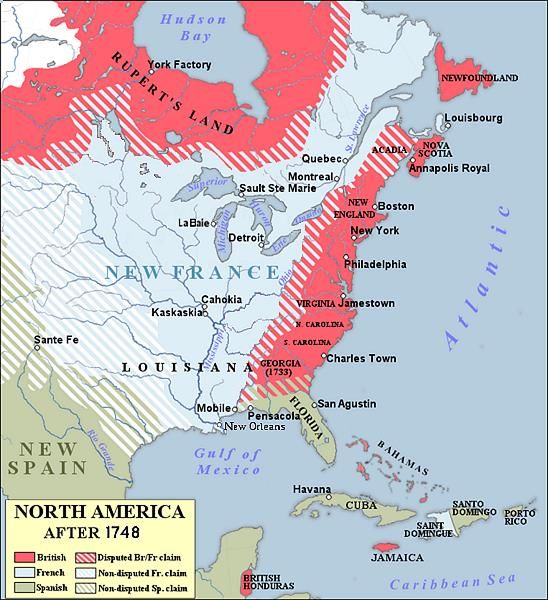
23. Project the North America in 1748 map (Student Resource Book).
24. Conduct a brief discussion about the map. Possible questions:1. Where areas do the French claim on this map?
2. How would you characterize the size of the French claim?
3. If LaSalle claimed all the lands which waters drain into the Mississippi River, what is the
extent of France’s claim in the New World?
25. As a class, conduct a discussion about the impact of LaSalle claiming Louisiana for France.
Encourage students to use the conversation stems during the discussion and provide evidence
from the documents and outside knowledge to support their answers. Possible questions
(Student Resource Book):
1. Why did LaSalle have representatives of the Catholic Church with his expedition?
2. Why was the ceremony to claim Louisiana for France held at the mouth of the
Mississippi River?
3. What did France hope to gain economically and politically with the acquisition of
Louisiana?
4. What does the 2 documents tell you about the power of King Louis XIV?
5. How were the Native Americans living along the Mississippi River going to be affected
after LaSalle claimed Louisiana for France?
26. Say, “After the King and his ministers find out about the tragedy of LaSalle’s final expedition,
they become worried that France could lose Louisiana because France did not have a fort at
the mouth of the Mississippi River to protect their new lands from the Spanish and British.”
27. Have the students to continue reading independently and filling in the timeline.
28. Say, “Life in French Louisiana was extremely difficult. Iberville was not able to set up a colony
on the Mississippi River like he had hoped to, so the French were settled in modern day Biloxi
Mississippi. The colonists lacked supplies, and they had not set up a great trading network
with Native Americans for furs. This directly impacted the economy of the colony since they
need a settlement at the mouth to secure a better trading network for furs. Eventually,
Bienville is able to set up a settlement on the Mississippi River.”
29. Have the students to continue reading independently and filling in the timeline.
30. Project the Early Map of New Orleans (1728) (Student Resource Book).
31. Direct students to analyze the Early Map of New Orleans (1728), using the National Archives:
Analyze a Map handout (Student Resource Book).
32. Say, “We now have an understanding of French exploration of Louisiana and the challenges
faced by early colonists. Consider the contributions and legacy of French exploration on
Louisiana. How has the French exploration of Louisiana contributed to our identity as a state?”
33. This instructional task can be concluded with the extended response prompt found in the
Resource Book, “How has the French exploration of Louisiana contributed to our identity as a
state?”
34. The Extended Response Rubric AND Extended Response Checklist are at the end of this
document as well as in the Google Classroom. Please copy and distribute to students to be
kept in their notebooks/binders.Directions:
Discuss and answer the following questions with a partner.
1. Which physical characteristic of Louisiana would make Louisiana enticing to
European colonization?
___________________________________________________________________
___________________________________________________________________
___________________________________________________________________
___________________________________________________________________
2. Which physical characteristic of Louisiana gave European’s access to the interior of
North America?
___________________________________________________________________
___________________________________________________________________
___________________________________________________________________
___________________________________________________________________
3. Why were European explorers drawn to Louisiana? Give an economic reason and
military reason.
___________________________________________________________________
___________________________________________________________________
___________________________________________________________________
___________________________________________________________________
___________________________________________________________________
___________________________________________________________________
___________________________________________________________________
___________________________________________________________________Directions:
Complete the timeline as we analyze documents on Louisiana exploration.
Timeline of European Exploration of Louisiana
(please see the
Student Resource Book for this timeline)Source 1
“De Soto on the Shore of the Mississippi River “
Drawn by H.L. Stephens, engraved by Augustus Robin, N.Y – 1893
64parishes.org
1. Who are the different people in the engraving?
___________________________________________________________________
___________________________________________________________________
___________________________________________________________________
___________________________________________________________________2. What are the people doing in the engraving?
___________________________________________________________________
___________________________________________________________________
___________________________________________________________________
___________________________________________________________________
3. What objects are in the engraving?
___________________________________________________________________
___________________________________________________________________
___________________________________________________________________
___________________________________________________________________
4. Describe the physical geography of the engraving.
___________________________________________________________________
___________________________________________________________________
___________________________________________________________________
___________________________________________________________________
Spanish Exploration in the Gulf of Mexico
Florida represented the entryway for Spanish exploration of North America during the early sixteenth
century. Juan Ponce de León discovered “the island of Florida” in 1513. Though brief, Ponce de León’s
voyage to Florida opened the Gulf of Mexico to future Spanish crews. After experiencing considerable
navigational and weather-related difficulties, Pánfilo de Narváez landed at present-day Tampa Bay,
Florida, in 1528, and members of the expedition promptly antagonized the local Native American
population with their martial activities and demands. Narváez’s brutal, uncompromising interaction
with the Apalachee of north Florida led to the dispersal of the crew members. Alvar Nuñez Cabeza
de Vaca was one of approximately eighty survivors who built and boarded a crude watercraft bound
for Cuba, only to disembark several months later near present-day Galveston, Texas. Cabeza de Vaca,
along with two other Spaniards and an enslaved African, finally reached an expedition of Spanish
slavers in present-day Sinaloa, Mexico, in 1536. A published account of Cabeza de Vaca’s adventures
appeared soon thereafter, including fantastic (if not fabricated) tales of European-Indian interaction
in a “new” world.Hernando de Soto followed the failed Narváez expedition with a slightly more successful one of his own in 1538. De Soto and his crew disembarked in an area of Florida inhabited by the Timucua. De Soto’s men made inland treks in search of precious metals, but with no success. After consulting a surviving member of the Narváez crew, de Soto decided to travel along the Gulf Coast toward the region that would become New Mexico. Rumors of gold led the overland expedition to present-day Alabama and along the Tombigbee River to present-day Mississippi, all while the group was taking considerable casualties in skirmishes with Native American warriors. In June 1541, de Soto and the remaining crew reached the Rio del Espiritu Santo, later called the Mississippi River, near the mouth of the White River in present-day Arkansas. De Soto died less than a year later in 1542, whereupon what remained of the Spanish crew sank his body in the Mississippi River. The crew proceeded westward through lands inhabited by the Caddoan peoples, only to return to the Mississippi River where they prepared to reach the Gulf of Mexico by river. Some 322 crew members departed on a seventeen-day voyage to the Gulf, leaving behind more than five hundred Native Americans who had been forcibly removed by the Spanish from other parts of the Southeast. De Soto’s expedition marked the first European exploration of the lower Mississippi River. It would be more than a century before another group of Europeans reached its waters. Roman Catholic missionaries started to join Spanish crews in the exploration of Florida during the latter half of the sixteenth century. Dominican priests associated with the missionary reformer Bartolomé de las Casas conducted evangelistic enterprises that resulted in the death of several clergymen and the perpetuation of European-Native American antagonism. With a rise in the recurrence of shipwrecks along the Gulf Coast, clerics and laymen convinced the Spanish king to take drastic, violent measures against “savage” Indians posing obstacles to the settlement of Florida. Tristán de Luna y Arellano, the newly appointed governor of Florida, set sail from Mexico in 1559 with approximately five hundred soldiers, two hundred horses, and a thousand men, women, and children of European, Native American, and African descent. The goal was to transplant the Spanish model of government to North America and, in effect, “Christianize and civilize” the Native American population. Luna’s fleet of eleven vessels made landfall at Ochusa (present-day Pensacola Bay) in 1559, only to be met with a devastating hurricane, burdensome inland treks, and mutiny. The viceroy of New Spain sent Ángel de Villafañe to replace Luna as governor of Florida in 1561, though he also suffered a setback when a hurricane hit his fleet near the Carolina coast. Afterward, Villafañe oversaw the abandonment of the battered Pensacola colony, thus leaving the Gulf Coast uninhabited by Europeans, aside from castaways left for dead. https://64parishes.org/entry/early-exploration Complete Box 1 on the Timeline
French Exploration in Canada
While the English and Dutch challenged Spanish supremacy of the Gulf of Mexico, the French focused
their imperial goals on the exploration of the St. Lawrence River Valley during the sixteenth and
seventeenth centuries. The French ruler would have preferred to establish colonies in Brazil and
other areas of South America, but the presence of Portuguese and Spanish settlements proved too
strong for French advances. Francis I, king of France, also contended with European notions of
sovereignty and colonialism that depended upon the sanction of the Roman Catholic pontiff. It was
not until 1533 that Francis I convinced Pope Clement VII of France’s right to occupy lands previously
unknown or unsettled by European kingdoms, thus reversing the 1493 papal bull Inter caetera, which
had previously divided the New World between Portugal and Spain.

Francis I acted quickly after the pope’s reversal, and in 1534 Jacques Cartier became the first
Frenchman to lead a major expedition in search of a western route across North America to the
Pacific and mineral resources comparable to those found in South America. Cartier’s first expedition
into the Gulf of St. Lawrence did not result in any great discoveries, though he did develop ties with
the Iroquois and brought several Iroquoians back to France. A second expedition, more ambitious
and better funded than the first, resulted in the beginning stages of settlement near present-day
Montreal. In neither expedition did Cartier intend to execute large-scale colonization and missionary
enterprises in Canada. He did, however, return to France with an Iroquois chief who reported on the
existence of a northern kingdom with great mineral wealth. A third voyage set sail in 1541 with the
goal to find the fabled land of gold and diamonds. Again, Cartier failed to satisfy Francis I’s dream of
discovering treasure in the New World, after which he returned to France in 1542, having
undermined whatever diplomatic inroads he had made with the Iroquois of the St. Lawrence River
Valley.

The French continued to fish the seas of the North Atlantic following Cartier’s failed expeditions of
the 1530s and 1540s. In 1603, King Henri IV granted Pierre du Gua, Sieur de Monts, a fur trade
monopoly in the lands of Acadia and the St. Lawrence River Valley. De Monts, in turn, commissioned
Samuel de Champlain to establish a base for trading operations on the St. Lawrence River, after which
the ambitious explorer founded Quebec City in 1608. The encroachment of Dutch traders and French
competitors complicated Champlain’s hopes for the discovery of a western passage and the
accumulation of wealth for company and crown. French involvement in wars between the Algonquin
and Iroquois also frustrated the fur trade and the stability of the fledgling colony as a whole. Cardinal
Richelieu, the king’s first minister, supported an unprecedented level of monetary investment and
personnel allocation in the colonization of New France, only to be foiled by English privateers in 1628.
Champlain surrendered Quebec to a band of Englishmen in 1629.

Champlain, along with forty crew members and three Jesuits, conducted the reoccupation of Quebec
in 1632. Growth was slow, as only 356 individuals—158 men, 116 women, 29 Jesuits, and 53
soldiers—resided in and around Quebec by 1640. French involvement in the Thirty Years’ War (1618–
1648) led to a reduction in Crown support for the development of New France. What little assistance
You can also read