2020 Thornton Bales Conservation Area Management Plan - Lake ...
←
→
Page content transcription
If your browser does not render page correctly, please read the page content below
Thornton Bales
Conservation Area
Management Plan

     2020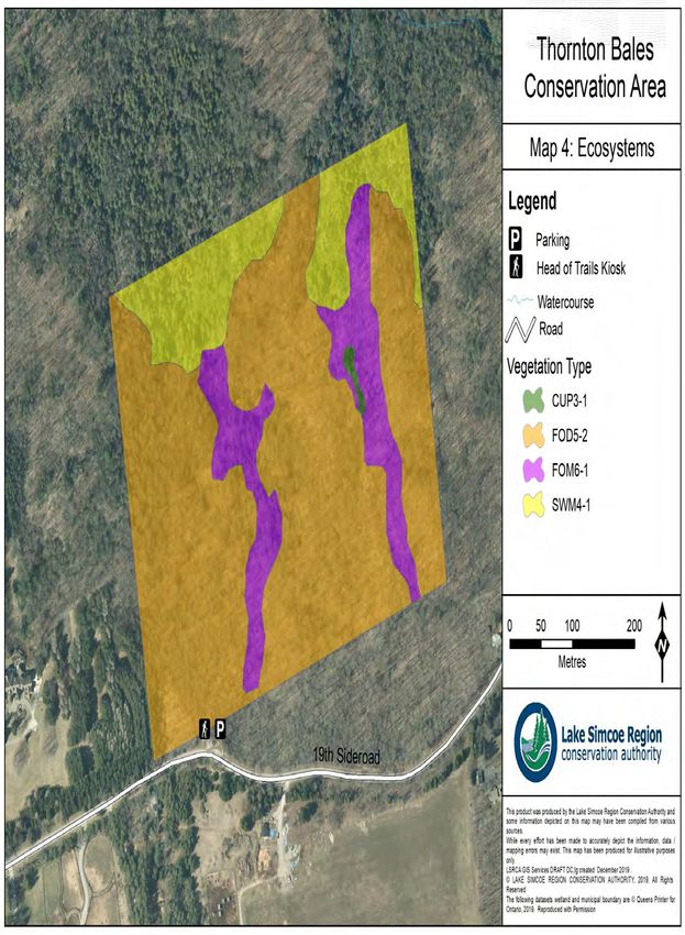
Table of Contents
     Table of Contents ................................................................................................................................... i
     List of Figures ........................................................................................................................................iii
Executive Summary..................................................................................................................................... 1
     Background ........................................................................................................................................... 1
     Consultation .......................................................................................................................................... 1
     Management Plan Goal and Objectives ............................................................................................... 2
     Management Plan Direction ................................................................................................................. 2
     Business Plan Direction ......................................................................................................................... 3
     Conservation Authority Resolution....................................................................................................... 4
Section I: Background Report ..................................................................................................................... 2
     Introduction .......................................................................................................................................... 2
     Site Location and Description ............................................................................................................... 4
     Property Acquisition ............................................................................................................................. 5
     Human History and Settlement ............................................................................................................ 5
     Topography and Soils ............................................................................................................................ 7
       Soil ....................................................................................................................................................... 7
       Topography ......................................................................................................................................... 7
     Climate .................................................................................................................................................. 9
     Hydrology ............................................................................................................................................ 11
     Ecosystems .......................................................................................................................................... 11
     Wildlife ................................................................................................................................................ 13
     Development and Infrastructure ........................................................................................................ 14
     Public Use ............................................................................................................................................ 14
     Landscape Influences .......................................................................................................................... 16
Section II: Management Plan Development ............................................................................................. 18
     Introduction ........................................................................................................................................ 18
     Steering Committee ............................................................................................................................ 19
     Internal Project Team ......................................................................................................................... 19
     Past Public Consultation Information ................................................................................................. 20

Thornton Bales Conservation Area Management Plan                                                                                            Page i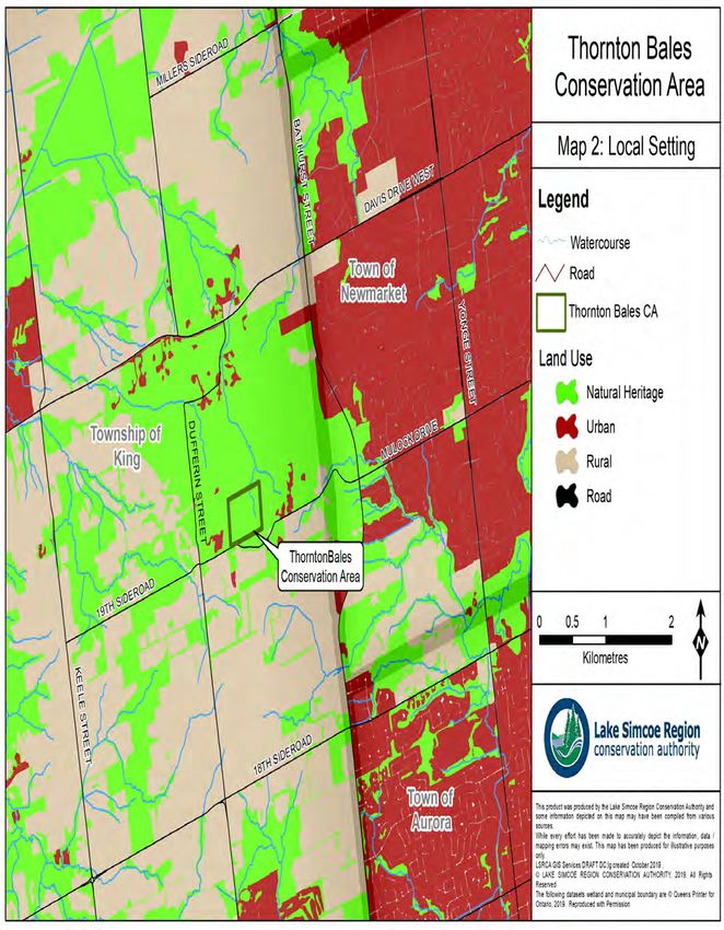
2007 Conservation Area User Survey ............................................................................................... 20
       2017 Conservation Area User Survey ............................................................................................... 21
       2018 Conservation Area User Survey ............................................................................................... 22
     Future Evaluation and Review of Management Plans ........................................................................ 24
Section III: Management Plan ................................................................................................................... 25
     Introduction ........................................................................................................................................ 25
     Selection of the Implementation Items .............................................................................................. 25
     Administration .................................................................................................................................... 26
     Asset Management/ Monitoring ........................................................................................................ 27
       Trails .................................................................................................................................................. 27
       Maintenance ..................................................................................................................................... 27
     Visitor Experience Management ........................................................................................................ 28
       Smoking ............................................................................................................................................. 28
       Washrooms ....................................................................................................................................... 28
       Signage Strategy................................................................................................................................ 29
     Boundary Management ...................................................................................................................... 29
     Natural Heritage Feature Management ............................................................................................. 29
       Forest Management.......................................................................................................................... 30
       Invasive Species ................................................................................................................................ 30
       Climate Change Adaptation .............................................................................................................. 30
     Partnership Development/ Engagement ............................................................................................ 31
Section IV: Business Plan........................................................................................................................... 33
     Introduction ........................................................................................................................................ 33
     Budget Projection ............................................................................................................................... 34
     Projected Expenses ............................................................................................................................. 34
       Full Time Equivalent (FTE) ................................................................................................................. 35
     Projected Revenues ............................................................................................................................ 35
       Municipal Levy .................................................................................................................................. 36
       Special Capital ................................................................................................................................... 37
       University of Toronto/ Jokers Hill (in-kind contribution).................................................................. 37
       King Township ................................................................................................................................... 37

Thornton Bales Conservation Area Management Plan                                                                                          Page ii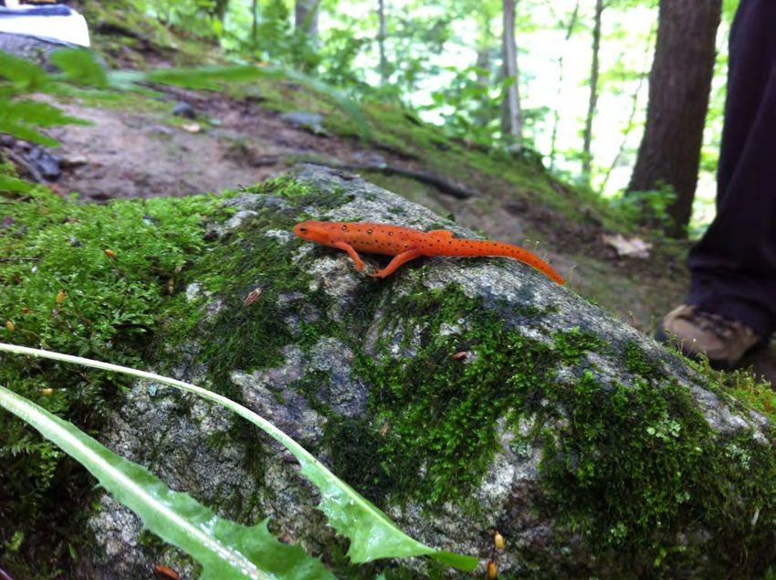
Greenbelt Foundation ....................................................................................................................... 37
       Parking Fee Revenue ......................................................................................................................... 37
       Sponsorship Revenue........................................................................................................................ 38
       Grant Funding ................................................................................................................................... 38
     Implementation Schedule: 2020 – 2024 ............................................................................................. 39
       2020 .................................................................................................................................................. 39
       2021 .................................................................................................................................................. 43
       2022 .................................................................................................................................................. 47
       2023 .................................................................................................................................................. 51
       2024 .................................................................................................................................................. 55
References ................................................................................................................................................ 60

List of Figures
Map 1 Regional Setting ................................................................................................................................6
Map 2 Local Setting......................................................................................................................................8
Map 3 Thornton Bales Conservation Area .................................................................................................10
Map 4 Ecosystems......................................................................................................................................12

Thornton Bales Conservation Area Management Plan                                                                                       Page iii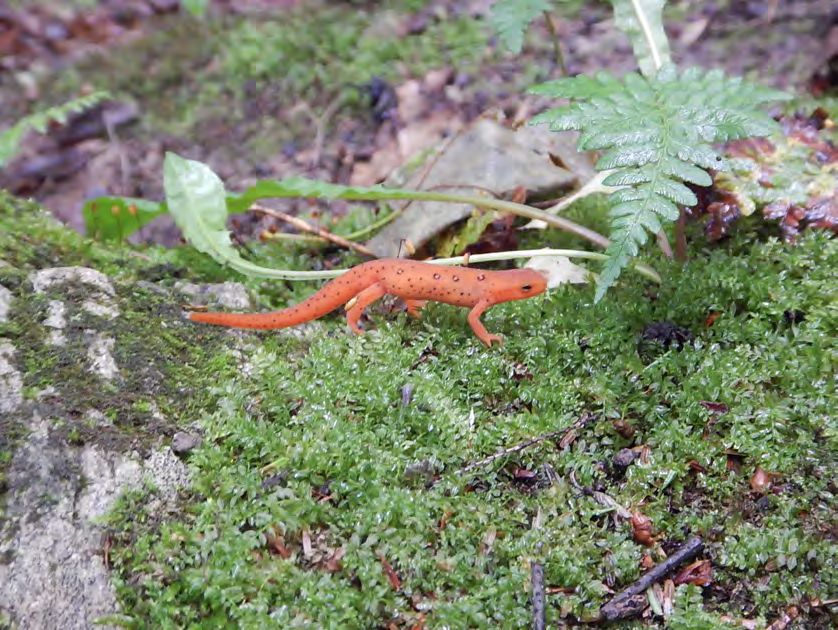
Executive Summary

Executive Summary
The Management Plan has been written in four sections, including: a Background Report which
summarizes and synthesizes information on the natural heritage of the property and its current
levels of development and public use; a Development of the Revised Plan section which
describes the public consultation process and input received during plan review, as well as
outlining the process and timeline for future plan review; a Management Plan which identifies
long- and short-term goals for the management of the property; and a Business Plan which
provides a description and schedule of implementation priorities, coupled with projections of
revenues and expenses over a five year period.

Background
Thornton Bales Conservation Area is 20 ha (50 acres) in size, and is located in the Township of
King. It is located within the northern margins of the Oak Ridges Moraine, which contributes to
the wide variety of habitats on the property, including upland forest, lowland forest, and
forested wetlands. This diversity of habitat also supports a wide diversity of species on the
property. This property has been identified in the York Region Official Plan and the Township of
King Official Plan as an Area of Natural and Scientific Interest (ANSI).
Mr. Thornton J. Bales first purchased the property in 1911 and later donated it to the Township
of King with the expectation that it would be maintained as a natural area. Mr. Bales recognized
the property’s recreational and wildlife potential and wanted to ensure its protection for future
years. King Township donated the property to the Holland Valley Conservation Authority in
1961, which then became the South Lake Simcoe Conservation Authority. In 1970 the South Lake
Simcoe Conservation Authority changed the name of the property from King Conservation Area
to Thornton Bales Conservation Area, to honour the late Mr. Bales. The current Lake Simcoe
Region Conservation Authority still owns and manages Thornton Bales Conservation Area.
A Master Plan was prepared in 1979 to guide the management of the property. Since that time a
Natural Heritage Inventory was undertaken (2010), which includes a list of the species that
utilize the habitat at Thornton Bales Conservation Area (TBCA), with a particular focus on
vegetation and breeding birds.

Consultation
Consultation has played an important role in the development of this Management Plan. The
public were provided opportunities to deliver feedback and to voice their thoughts, values and
opinions of Thornton Bales Conservation Area. The Public Consultation phase consisted of an
online user survey, which was available from September 19th to November 23rd, 2018.
A Steering Committee was developed in the summer of 2018 to provide direction throughout
the Management Plan development process. The Committee met periodically to review the
steps of the development process, to review the information collected through the consultation
phase, and to assist in developing the direction the final Management Plan would take. The

Thornton Bales Conservation Area Management Plan                                        Page 1
Executive Summary

Steering Committee was supported by an Internal Project Team composed of staff experts from
various departments within LSRCA.

Management Plan Goal and Objectives
The goal and objectives of this Management Plan were developed by an Internal Project Team,
then reviewed and amended by the Steering Committee before being finalized.

Goal:
Thornton Bales Conservation Area will be managed to sustain the ecological integrity of the Oak
    Ridges Moraine and its natural features and functions, while providing for compatible
             recreational, educational and research activities with our partners.

Objectives:
   1. Continue to provide compatible recreational opportunities through maintenance and refinement
      of the trail network, while ensuring a balance between recreational uses and conservation of
      important natural heritage features
   2. Develop and implement a signage strategy along with creating updated property and trail maps
      for users
   3. Maintain a healthy forest ecosystem for future generations through the implementation of
      sustainable/best forest management practices
   4. Protect and enhance/restore the natural heritage features located on the property through
      invasive species monitoring and removal, and through conserving the biodiversity and native
      species currently present on the property
   5. Promote physical and mental well-being by encouraging members of the community to
      participate in a range of healthy activities including quiet contemplation, nature connection, and
      recreational activities in this natural setting
   6. Enhance opportunities for user engagement, appreciation, and education on the property with
      our partners

Management Plan Direction
This Management Plan provides the basis and long-term direction for the management of
Thornton Bales Conservation Area. It is based on identification of the constraints and capabilities
provided by the property (Section I), and public, internal and stakeholder consultation (Section
II).
There are fewer implementation objectives identified in this Management Plan than are
generally outlined in other conservation area management plans within the Lake Simcoe Region
Conservation Authority landholdings. This may be attributed to a number of factors, including
property size, level of infrastructure, desired activities and ideal use levels. Since Thornton Bales
Conservation Area is a more ecologically sensitive property, due to its location on the Oak Ridges
Moraine and its steep topography, significantly increasing property usage could have negative
impacts on the conservation area and the associated natural heritage features. The lack of
amenities that are currently offered at TBCA are a result of this, and is also why it has been

Thornton Bales Conservation Area Management Plan                                              Page 2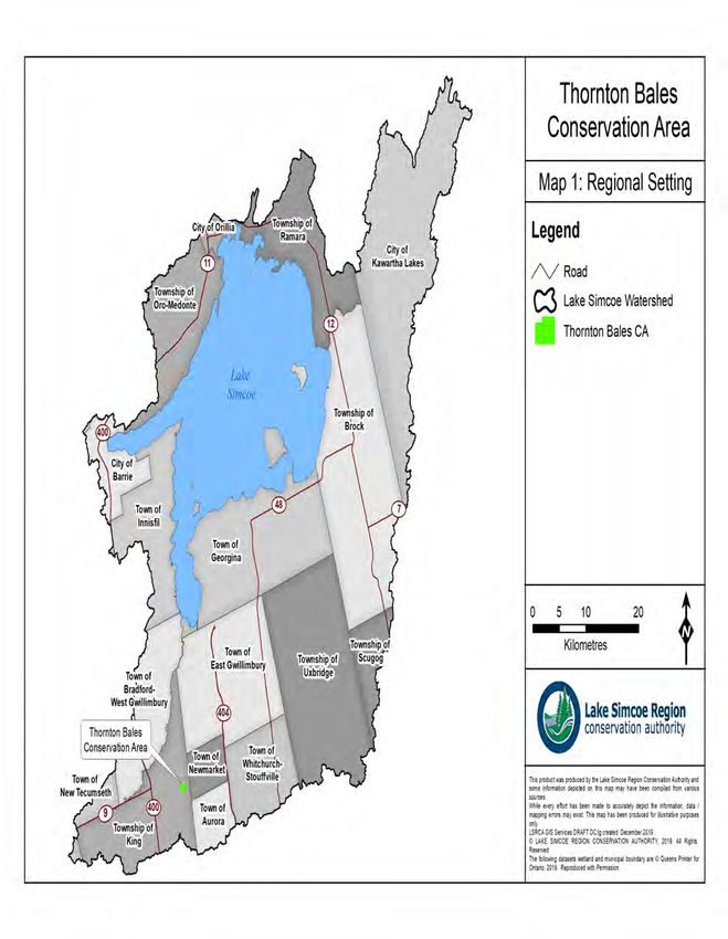
Executive Summary

classified as a Passive Recreation Area in the Conservation Landholding Assessment 1. More
specific information regarding the Management Plan direction can be found in Section 3:
Management Plan, which describes in more detail some of the activities and implementation
objectives which are included in the five year Business Plan, and provides background
information and additional justification for those items.

Business Plan Direction
The purpose of a conservation area management plan is to establish long- and short-term goals
for the management of the property and to identify priorities for implementation. The Business
Plan component is a description and schedule of implementation priorities, coupled with
projections of revenues and expenses over a five year period.
In addition to revenues and expenses, this Business Plan will identify potential funding sources
and provide guidance for LSRCA management in implementing the Thornton Bales Conservation
Area Management Plan. To these ends, priorities for investing in amenities and infrastructure for
the period of 2020 to 2024 have been identified (Table 1). The items listed in Table 1 are
considered outside the scope of regular maintenance and establish a proactive management
approach, however, all activities including regular maintenance and monitoring are outlined in
the Implementation Schedule.
Implementing all of the objectives outlined in the Business Plan is projected to cost $79,800 as
well as additional staff time (approximately 2.64 FTE).

1
    LSRCA (2016b)

Thornton Bales Conservation Area Management Plan                                         Page 3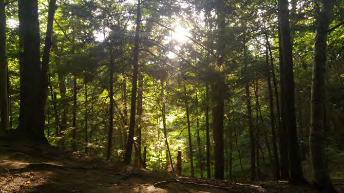
Executive Summary

Table 1: Implementation Priorities
 Implementation             Implementation Priorities
 Year
 2020                   •   Update information on LSRCA’s website
                        •   Re-align the trail network
                        •   Develop and install new trail way-finding signs at trail intersections
                        •   Conduct a forest stand inventory
 2021                   •   Install animal-proof garbage bins
                        •   Design and install new trail maps and kiosk
                        •   Host a volunteer day
 2022                   •   Add interpretative signage to the conservation area
                        •   Conduct a Natural Heritage Inventory
                        •   Implement a parking fee at Thornton Bales Conservation Area
                        •   Implement Best Management Practices for forest stand health
 2023                   •   Implement a no-smoking policy within the conservation area
                        •   Continue to add interpretative signage to the property
                        •   Find solutions to expand limited parking spaces
                        •   Implement Best Management Practices for forest stand health
 2024                   •   Begin the 5 year Management Plan Evaluation and Review
                        •   Continue to implement Best Management Practices for forest stand
                            health
                        •   Continue to host annual volunteer day

Conservation Authority Resolution
Moved by: A. Eek
Seconded by: M. Quirk

        BOD-064-20 RESOLVED THAT Staff Report No. 25-20-BOD regarding the Thornton Bales
        Conservation Area Management Plan be received; and
        FURTHER THAT the Management Plan and associated Business Plan be approved; and
        FURTHER THAT staff continue to pursue funding and in-kind support to implement the
        recommendations of the Management Plan. CARRIED

Thornton Bales Conservation Area Management Plan                                           Page 4
Background Report
Section I: Background Report
Introduction
Since 1951, Lake Simcoe Region Conservation Authority (LSRCA) and its predecessors have
provided a leadership role in the protection and restoration of the environmental health of the
Lake Simcoe watershed. LSRCA is mandated under the provincial Conservation Authorities Act to
“establish and undertake, in the area over which it has jurisdiction, programs and services
designed to further the conservation, restoration, development and management of natural
resources other than gas, oil, coal and minerals”.
Conservation areas are an important part of this mandate as they represent the Authority’s
opportunity to secure and manage some of the most sensitive natural heritage features in the
watershed, demonstrate appropriate approaches to land and water stewardship, provide public
education opportunities, and contribute to outdoor recreation. The public view the protection of
these lands, as well as the access for public use, as one of the most important contributions of
the Authority to the communities it serves. As the watershed continues to urbanize, the role of
conservation areas will become even more critical for visitors and mental health well-being.
To date, LSRCA owns, manages, or holds easements over approximately 2,425 hectares (5,992
acres) of conservation lands throughout the watershed. These lands include important natural
features such as valleys, forests and wetlands. Conservation areas promote natural heritage
protection and offer a range of unique outdoor experiences to the public.
Thornton Bales Conservation Area (TBCA), a property owned and managed by LSRCA, is
approximately 20 ha (50 acres) in size, and is located in King Township. Due to its location within
the northern margins of the Oak Ridges Moraine, this property contains a wide variety of
habitats and floral and faunal species. It is identified in the York Region Official Plan and the
Township of King Official Plan as an Area of Natural and Scientific Interest (ANSI).
Thornton Bales Conservation Area was first acquired by LSRCA in 1961, when it was known as
King Conservation Area. It was renamed in 1970 to honour the late Mr. Bales, who purchased
the property in 1911, then donated it to King Township for a nominal sum. Mr. Bales recognized
the property’s recreational and wildlife potential, and wanted to ensure its protection for future
years. In 1961, King Township donated the property to the Holland Valley Conservation
Authority, which today, is known as the Lake Simcoe Region Conservation Authority. A Master
Plan was prepared in 1979 to guide the management of the property, but has since become
outdated. The goals and objectives outlined in that Master Plan included:
Goal:
To manage and conserve the natural quality of the lands, forests and wildlife of Thornton Bales
Conservation Area.
Thornton Bales Conservation Area Management Plan Page 2Background Report
Objectives:
• To preserve the natural integrity of the area
• To protect the natural water recharge value of the area
Throughout the Master Plan (1979) it was made very clear that the property was a sensitive area
with key natural heritage features that must be protected. In order to maintain them, only low
intensity, passive day-use recreation was permitted on the property. This condition has
remained and will be re-established in this current Management Plan.
Due to changes over time, increased visitation rates, recreational activities, pressures and public
expectations, a new goal and objectives were developed for Thornton Bales Conservation Area.
Goal:
Thornton Bales Conservation Area will be managed to sustain the ecological integrity of the Oak
Ridges Moraine and its natural features and functions, while providing for compatible
recreational, educational and research activities with our partners.
Objectives:
1. Continue to provide compatible recreational opportunities through maintenance and
refinement of the trail network, while ensuring a balance between recreational uses and
conservation of important natural heritage features
2. Develop and implement a signage strategy along with creating updated property and trail
maps for users
3. Maintain a healthy forest ecosystem for future generations through the implementation
of sustainable/best forest management practices
4. Protect and enhance/restore the natural heritage features located on the property
through invasive species monitoring and removal, and through conserving the
biodiversity and native species currently present on the property
5. Promote physical and mental well-being by encouraging members of the community to
participate in a range of healthy activities including quiet contemplation, nature
connection, and recreational activities in this natural setting
6. Enhance opportunities for user engagement, appreciation, and education on the
property with our partners
The purpose of a conservation area management plan is to establish long- and short-term goals
and to develop strategies by which those goals can be achieved. Periodic updates to existing
management plans are necessary to ensure the continued relevance of management policies. An
up-to-date management plan should be consistent with the Authority’s objectives, reflect
current site conditions and public uses, and address existing management challenges.
The management plan process was intended to be a collaborative one, building on and fostering
partnerships with the conservation area’s stakeholder groups through an interactive
consultation process. This process was facilitated by the LSRCA Land Management Technician
and guided by a Steering Committee.
Thornton Bales Conservation Area Management Plan Page 3Background Report
Site Location and Description
Thornton Bales Conservation Area is located at 1260 19th Sideroad, Concession, 2 Part Lots 30 &
31 in the Township of King, within the Regional Municipality of York. The primary access to the
property is from the north side of 19th Sideroad, approximately 3 km west of Bathurst Street,
where a parking lot and trail head are located for access into the property. Other access points
are available primarily by foot, through trail connections to other privately owned lands,
including Jokers Hill, owned by the University of Toronto.
The conservation area contains a rolling topography with steep slopes, requiring stairs to access
the interior of the property from the parking lot off 19th Sideroad, which is where the
conservation area received its nickname “The 99 Steps”.
According to both the Regional Municipality of York’s Official Plan 2 and the Township of King’s
Official Plan,3 Thornton Bales Conservation Area has been identified to contain multiple land
uses and landscape designations:
York Region Official Plan
• Woodland (York Region OP, Map 5)
• Environmentally Significant Area (York Region OP, Map 3)
• Earth Science Areas of Natural and Scientific Interest (York Region OP, Map 3)
• Existing Greenlands System and the Greenlands System Vision (York Region OP, Map 2)
• Oak Ridges Moraine Boundary (York Region Official Plan, Map 1)
• Landform Conservation Area Category 1 and Category 2 (York Region OP, Map 1)
Township of King Official Plan 4
• Environmentally Significant Area (King Township OP; Schedule B3-2)
• Earth Science Areas of Natural and Scientific Interest (King Township OP; Schedule B3-2)
• Landform Conservation Area Category 1 and Category 2 (King Township OP, Schedule B4- Oak
Ridges Moraine Landform Conservation Areas)
• Key Natural Heritage and/or Hydrologically Sensitive Feature (Schedule 5- Oak Ridges
Moraine Plan Area , Key Natural Heritage and Hydrologically Sensitive Features)
• Along the Greenbelt Cycling Route (King Township OP, Schedule J: Active Transportation)
In addition to these designations, both LSRCA mapping and King Township’s Official Plan identify
Thornton Bales CA as Rural and Open Space land uses 5. These designations support the rural
character, significant natural heritage features, and natural linkages contained within the
property which are important to protect and preserve.
2
Regional Municipality of York (2010)
3
Township of King (2017)
4
Township of King (2017)
5
LSRCA (2019a)
Thornton Bales Conservation Area Management Plan Page 4Background Report
Property Acquisition
Mr. Bales first purchased the property in 1911 and later donated it to the Township of King to
maintain it as a natural area. Mr. Bales recognized the property’s recreational and wildlife
potential and wanted to ensure its protection for future years. King Township donated the
property to the Holland Valley Conservation Authority in 1961. In 1970 the South Lake Simcoe
Conservation Authority (currently LSRCA) changed the name of the property from King
Conservation Area to Thornton Bales Conservation Area, to honour the late Mr. Bales.
A Master Plan was prepared in 1979 to guide the management of the property. Over the years
LSRCA staff has maintained the low intensity, passive day-use recreational trails and natural
heritage features of the property. More recently in 2010, a Natural Heritage inventory was
undertaken, which identified a broad list of the flora and fauna species that utilize the various
habitats at Thornton Bales Conservation Area, with a particular focus on breeding birds. 6
Human History and Settlement
Archaeological evidence suggests that First Nations peoples have been present on the land, in
King Township for many millennia beginning with the Iroquoian and Woodland First Nations.
More recently the area in and around Thornton Bales CA is in the traditional territory of the
Haudensaunee (Iroquois), Ojibway/Chippewa and Anishnabek. The first permanent settlement
in the area dates back to 1804 with the purchase of the land by Rufus Rogers. Numerous
individuals succeeded Rogers as owners of the property until in 1911, Thornton J. Bales, a
prominent resident of the area, purchased the west half of the lot.
During Bales’ later years, his interest in conservation led to a very generous agreement whereby
he donated 50 acres of his property to King Township for a nominal sum. The area was to be
designated parkland as Bales recognized the recreational and wildlife potential of the area. In
July of 1961, the park was turned over to the Holland Valley Conservation Authority. Then in
1970, the area was renamed in honour of the late Thornton Bales and has since been managed
by the Lake Simcoe Region Conservation Authority.
6
LSRCA (2010)
Thornton Bales Conservation Area Management Plan Page 5Background Report Map 1. Regional Setting Thornton Bales Conservation Area Management Plan Page 6
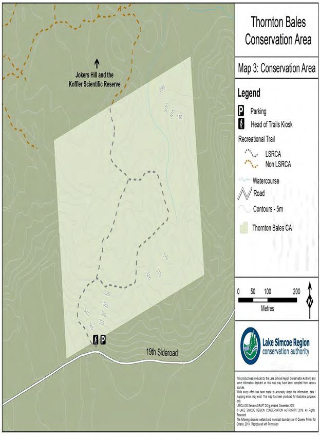
Background Report

Topography and Soils
When determining how best to manage a property, two key factors that are taken into
consideration include the site topography and soil composition. These two factors are a result of
the conservation area’s location on the Oak Ridges Moraine, making the property more
distinctive and providing it with notable natural heritage features, which makes the conservation
area a very unique property. Below are detailed descriptions of these factors, including how they
impact the property and how this may impact the future management of the property.

Soil
Thornton Bales Conservation Area consists primarily of a single soil type which is classified as
Pontypool sandy loam 7. Pontypool soil types are deep, coarse textured soils with seasonal free
water saturation, which allows for a high infiltration rate and low runoff when wet 8. Sandy loam
soils can quickly drain excess water, but cannot hold onto significant amounts of water or
nutrients for longer periods of time. Typically, plants growing in this type of soil may struggle
without additional assistance, such as a variety of groundcover species to aid in maintaining
moisture for longer. However, because TBCA contains a mature forest and has abundant plant
growth the decomposing leaves and plant matter each year likely supply new plants with
enough nutrients to thrive in this natural environment. Pontypool soils are typically found in
areas consisting of steep slopes, which is consistent with the topography in TBCA. This type of
soil is generally more susceptible to wind erosion, but this is minimized on the property due to
the presence of vegetation. It can be assumed that without vegetation at different levels in the
canopy, wind erosion would have greater impacts at TBCA. Therefore, the vegetation the
property, both tree canopy and ground cover, should be left undisturbed to maintain slope
stability, and minimize the impacts of erosion. Restoring locations with reduced vegetative cover
will also aid in maintaining slope stability while enhancing the ecological integrity of the area.

Topography
Thornton Bales Conservation Area was nicknamed “99 Steps” due to the stairs that were built in
order to minimize erosion on the slope and to make the property more accessible. The stairs
were recently rebuilt in order to improve their condition and to allow the safer usage of the
property for the public. Although the stairs are challenging, they are necessary to mitigate the
negative impacts on the environment visitor use. According to LSRCA’s topographic mapping and
survey’s, the southwest corner of the property, between the parking lot access and the start of
the stairs has an elevation of 350m above sea level. Here there is a dramatic decrease in
elevation, as displayed in Map 3. Generally, the property slopes downwards towards the
northeast corner, where the lowest elevation is nearly 295m above sea level 9.

7
  LSRCA (2018b)
8
  Hoffman & Acton (1974)
9
  LSRCA (2019c)

Thornton Bales Conservation Area Management Plan                                        Page 7
Background Report

Map 2. Local Setting

Thornton Bales Conservation Area Management Plan           Page 8
Background Report

Climate
The closest weather station to Thornton Bales Conservation Area with a consistent and reliable
history of records is the Toronto Buttonville Airport weather station, which is approximately 25
km away. On a larger scale, TBCA falls within the Simcoe climatic region 10.
Using climate data from Environment and Climate Change Canada and the Toronto Buttonville
Airport station, climate normals have been derived using data from 1981 to 2010 11. Over this 30
year period, this station experienced an average of 852.9mm of precipitation per year, with an
average of 717.4mm as rainfall, and 142.6cm as snowfall. Annual temperatures over this 30 year
period were also taken at the Toronto Buttonville Airport station, and state that the annual daily
temperature average is 7.7ᵒC. The average daily maximum was 27.1ᵒC in July, and the minimum
daily average was -10.2ᵒC in February.
LSRCA has completed a number of climate projections, on how climate within the Lake Simcoe
watershed will change in the future 12. LSRCA’s climate change projections for the Lake Simcoe
watershed suggest that in the future there will be a variety of impacts to natural processes and
features, as a result of changes in climate. Below is a broad list of changes that are projected to
occur in the future in the watershed 13:
     •   More extreme heat (+30ᵒC) days, and more extreme cold (-10ᵒC) days
     •   Increased risk of short-duration intense precipitation
     •   Warmer and shorter winters
     •   More winter precipitation falling as rain instead of snow
     •   More water deficits in the future
     •   Increased growing season length
Overall, by the year 2050 LSRCA’s research suggests a mean temperature increase of 3.3ᵒC for
the Lake Simcoe watershed. The mean air temperature increase during the summer is predicted
to be 2ᵒC, but the winter increase is predicted to be 4ᵒC14. Overall this is likely to impact the
conservation area from a shift in species composition, as animals and plants adapt to climate
change and adjust their ranges accordingly. For more information regarding climate and its
projected impacts on the Lake Simcoe Watershed, and on strategies on adaptation, please see
Climate Change Adaptation Strategy (2020) for more details15.

10
   Brown et al. (1981)
11
   Environment Canada (2019)
12
   LSRCA (2020)
13
   LSRCA (2019b)
14
   LSRCA (2019b)
15
   LSRCA (2020)

Thornton Bales Conservation Area Management Plan                                           Page 9
Background Report Map 3. Thornton Bales Conservation Area Thornton Bales Conservation Area Management Plan Page 10
Background Report
Hydrology
Thornton Bales Conservation Area is located in the West Holland River Subwatershed and lies
within the northern margins of the Oak Ridges Moraine. The Oak Ridges Moraine is known as a
water recharge and discharge area, which may result in the production of headwater streams, as
seen in the conservation area 16. The headwaters of Glenville Creek start within the boundaries
of TBCA, where it is a very small tributary which eventually feeds into the West Holland River.
Ecosystems 17
Thornton Bales Conservation Area is primarily a wooded area, with a variety of mature trees and
a trail network in the forest. In 2008/ 2009, a Natural Heritage Inventory was undertaken, which
focused on identifying habitat types, vascular plants, and breeding birds, and included a
vegetation survey and Ecological Land Classification for the property. In 2009 four types of
vegetation communities were identified according to the Ecological Land Classification. They are:
• Dry-Fresh Sugar Maple-Beech Deciduous Forest (FOD5-2),
• Fresh-Moist Sugar Maple-Hemlock Mixed Forest (FOM6-1),
• White Cedar-Hardwood Organic Mixed Swamp (SWM4-1),
• Red Pine Coniferous Plantation (CUP3-1).
The majority of the property is composed of the Dry-Fresh Sugar Maple- Beech Deciduous Forest
(FOD 5-2) community, which is dominated by mature sugar maple trees, with a relatively high
component of American beech in the canopy. At the time the inventory was conducted White
Ash was the third most dominant tree species, although this may change in the upcoming years
due to the infestation of the Emerald Ash Borer (EAB) and the impact it is having on ash trees.
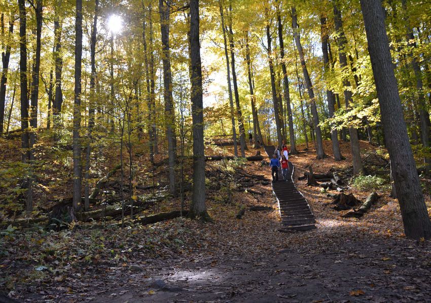
Figure 1: Image of the forest at Thornton Bales Conservation Area
16
Oak Ridges Moraine Land Trust (2019)
17
LSRCA (2010)
Thornton Bales Conservation Area Management Plan Page 11Background Report Map 4. Ecosystems Thornton Bales Conservation Area Management Plan Page 12
Background Report

Wildlife18
By itself, Thornton Bales Conservation Area is a smaller sized natural area when compared to
other LSRCA landholdings, but when combined with the neighbouring properties which have
also been preserved for natural heritage, the area is important. In 2008/2009, a Natural Heritage
Inventory was conducted on the property, which focused on breeding birds, and also recorded
amphibians and mammals on encounter or from calls. The breeding bird inventory identified 32
bird species, either by sight or sound, on the property. Six of these bird species are considered to
be regionally rare to the Lake Simcoe watershed, which highlights the ideal breeding and nesting
habitat on this property. Since no major changes have been confirmed to have occurred to the
composition of the natural heritage features within the conservation area, it can be assumed
that this property, along with the parcels it is connected to, still contain niche habitat
requirements for a variety of bird species. The most recent Natural Heritage Inventory identified
a number of bird species that are considered rare within the Lake Simcoe watershed, including
black-throated green warbler, scarlet tanager, yellow-bellied sapsucker, red-breasted nuthatch,
and winter wren.19

Figure 2: Image of an Eastern Newt at Thornton Bales Conservation Area

18
     LSRCA (2010)
19
     LSRCA (2010)

Thornton Bales Conservation Area Management Plan                                         Page 13
Background Report
Development and Infrastructure
Thornton Bales Conservation Area is a day use property, where members of the public can come
and enjoy a hike and immerse themselves in nature during the daylight hours, but no one is to
be on the property between dusk to dawn. Due to its day use designation, smaller size, and
lower carrying capacity based on site sensitivity, this property contains very limited
infrastructure. There is a parking lot located off of 19th Sideroad at the south end of the
property. There is also the famous “99 steps” located fairly close to the parking lot, and limited
signage on the property which is mostly found near the parking lot and the trail entrance.
Thornton Bales Conservation Area contains a trail system with natural surface cover, which is
representative of the topography of the moraine, with its steep slopes and low valleys. The trail
system is primarily an access trail to the bottom of the property, and then a loop. The loop has a
side trail that connects TBCA to Jokers Hill, owned by Koffler Scientific Reserve. This
conservation area property is a good fit for those who are physically active and up for a physical
challenge.
Since the development of the Master Plan in 1979 20, this conservation area has been focused on
supporting low-intensity, passive day-use recreation, which includes activities such as hiking and
nature appreciation. This property is becoming increasingly busy, with more new users visiting
each year, and regular visitors returning frequently 21. In order to accommodate the increase in
use, while still providing a unique and rural experience for users, it is recommended that
minimal development be supported for Thornton Bales Conservation Area, such as trail
improvements, but not the construction of any permanent buildings. Improvements to existing
infrastructure are acceptable, such as the entrance signage, parking lot retrofits, and regular
monitoring and maintenance. Additional infrastructure with the purpose of improving visitor
experience will be reviewed on a case-by-case basis, with a focus of keeping visitors on the trail
and reducing impacts. Some of these items may include increased parking spaces, increasing
trail accessibility, and providing way finding signage throughout the trail system.
Public Use
Thornton Bales Conservation Area is known to many as the “99 steps”, even though there never
were 99 steps, and is widely used by members of the public. It has two primary access points;
one being the parking lot located along 19th Sideroad, and the other being the trail connection to
Jokers Hill, which can be accessed from Bathurst Street just north of Keith Avenue.
For its size, Thornton Bales Conservation Area receives a reasonably high volume of users,
compared to other conservation areas in the watershed. The 20 hectare property contains a
limited trail network composed of natural surface trails, along the steep slopes of the Moraine.
There are a few limiting factors preventing all members of the general public from utilizing this
property, including limited parking spaces, a lack of trail maps and markers, and most notably
20
SLSCA (1979)
21
LSRCA (2018a)
Thornton Bales Conservation Area Management Plan Page 14Background Report
the extensive staircase resulting from the rugged terrain and change in elevation, which at times
may be quite challenging to maneuver. However, it still receives regular use from the public.
Conducting surveys of conservation area visitors is a great way to gain a more in-depth
understanding of who is using the property and for what types of activities. To date, three
Conservation Area User Surveys have been conducted for Thornton Bales Conservation Area
(2007, 2017 and 2018). Below are very short descriptions of the key findings, but more detailed
survey results are summarized in Management Plan Development (Section 2).
The first conservation area user survey for TBCA was conducted in 2007 22, where results
indicated that the primary user group were males between the ages of 20 and 30, who resided
within 10-20 km from the conservation area. They visited once or twice a month on average,
participated in multiple activities, primarily hiking, and visit mostly in the summer.
According to the 2017 survey, females were the dominant user group of the property. The most
common age category was 21 to 29 year old females who live within 10 km of the conservation
area, yet driving personal vehicles is the most common method to arrive at the property. The
majority of visits by the public were in the summer, and the majority of activities participated in
by users were hiking and nature appreciation.
The 2018 User Survey was specifically focused on TBCA to aid in the development of this
management plan. These results changed notably from the results in the 2017 survey. This may
be because this survey was conducted later in the fall when school was back in session, which
likely reduced some people’s ability to visit the property, and therefore not all users were aware
of the survey. Best efforts were made to advertise the survey and promote users to complete it,
including signage on the property, e-mails out to community groups and the Thornton Bales
Conservation Area e-mail group composed of interested members of the public, and sponsored
Facebook and Instagram posts. In the 2018 survey, the most common responses were from
females between the ages of 45 to 64, who live less than 10 km away, hike, and visit a few times
a year. More details regarding the survey results are discussed in Section II: Management Plan
Development.
Comparisons of these results show that consistently, users of Thornton Bales Conservation Area
live within 10 km of the property, primarily participate in hiking, and visit mostly in the summer.
Additional user groups who frequent the property are members of the Oak Ridges Trail
Association (ORTA). A portion of the ORTA trail previously ran through Thornton Bales
Conservation Area and connected it to Jokers Hill. ORTA members regularly organized hikes
across the moraine utilizing ORTA trails and staged them out of specific locations, such as the
parking lot at TBCA. This parking lot off 19th Sideroad is also an official stop on the Greenbelt
cycling route. This provides cyclists a destination where they can stop and rest. Both the Oak
Ridges Trail and the Greenbelt Cycling Route likely encourage visitors who typically may not visit
the property with a reason to visit. Both of these trail networks are significantly larger and more
extensive than the conservation area’s portion of trail. Thornton Bales Conservation Area also
22
LSRCA (2007)
Thornton Bales Conservation Area Management Plan Page 15Background Report
has a number of Geocaches located within its boundaries, which entices a different user group
to visit the property as well.
In order to gain a more accurate count of how many people are utilizing the trails at Thornton
Bales Conservation Area, a trail counter program is currently underway which will quantify the
amount of people using the trails, and will continue for the foreseeable future, or until at
minimum one full year of data is collected. It is recommended that a minimum of three or four
trail counters be installed: one at the kiosk, one at the soon to be developed bike station, one at
the top of the steps and one at the trail intersection near the bottom of the steps. Having trail
counters in these locations should collect accurate data on all users of the property, as well as
provide information on where they are coming from (eg. the parking lot off 19th Sideroad,
cycling to the property, or entering from the trails at Jokers Hill. This information would
complement the user surveys nicely and would allow LSRCA to determine a fairly accurate
estimate of how many people are visiting the property.
Landscape Influences
The Oak Ridges Moraine itself is the factor that has the largest single influence over Thornton
Bales Conservation Area and its natural processes. Thornton Bales Conservation Area sits just
within the northern margins of the Moraine, and is therefore characterized by many of its
features. The Moraine is essentially a deposition of material that was scraped from surrounding
areas and was deposited when the glaciers either retreated or melted. The Oak Ridges Moraine
generally runs parallel to the northern shore of Lake Ontario, and spans about 200 kilometres
from the Niagara Escarpment to the Trent River. The Moraine acts as a watershed boundary
between Lake Ontario and Lake Simcoe, and filters rainwater through its porous soils to form
approximately 30 rivers between both watersheds 23. The steep slopes requiring the stairs and
undulating hills within Thornton Bales Conservation Area are key characteristics of the Moraine,
as well as the headwaters of Glenville Creek, which eventually flows into the West Holland River.
The surrounding land uses also influence the conservation area. The property boundaries to the
north and east are connected to a larger network of greenspace, owned by the University of
Toronto and previously used for scientific research. These areas are now open to the public and
are used as a hiking trail network. The connection of greenspace between Jokers Hill, Koffler
Scientific Reserve, and TBCA creates an ideal, connected, natural corridor, which allow for the
safer movement of animals through this area. Within close proximity are a number of large
estate lots and houses. Although these properties do not have the same natural heritage
significance, they are a lower impact and less intensive landuse, which has limited impacts on
the conservation area, since the private properties that border the conservation area are
typically natural, not manicured landscape, which provides a buffer to the conservation area.
23
Oak Ridges Trail Association (2019)
Thornton Bales Conservation Area Management Plan Page 16Background Report
Over recent years the population living within close proximity to the conservation area has
increased. In 2011 the population in King was 19,899 24, Newmarket was 79,978 25, and was
1,032,524 in York Region 26. This has grown to be 24,512 in 2016 in King Township, 84,224 in
Newmarket, and 1,109,909 in York Region. Since there are many new housing developments
within close proximity to the property, it can safely be assumed that there will be increased
visitation on the existing properties. This increasing usage and visitation could have significant
negative impacts on Thornton Bales Conservation Area, which is why proactively managing this
property is crucial, by accounting for the expected increased usage is managed in a proactive
way to support the natural environment and features.
24
Statistics Canada (2016a)
25
Statistics Canada (2016c)
26
Statistics Canada (2016b)
Thornton Bales Conservation Area Management Plan Page 17Management Plan Development Section II: Management Plan Development Introduction The first plan to provide direction for the management of Thornton Bales Conservation Area was the Master Plan, developed in 1979. This plan focused on preserving the natural heritage values of the property while balancing it with day-use recreation. The only other guiding document for Thornton Bales Conservation Area was a Natural Heritage Inventory which was conducted in 2008 and 2009, and focused on Ecological Land Classification, vegetation and breeding bird inventories, and noted incidental observations of mammals and amphibians. The data from this inventory was used to aid in the development of this Management Plan. In 2009 LSRCA began developing Management Plans for some of the more actively used conservation area properties. Scanlon Creek Conservation Area was the first property to have a Management Plan developed (2009, updated 2015); Sheppard’s Bush Conservation Area (2009, updated 2017); and the Beaver River Wetland Conservation Area (2010, updated 2019). In 2018/2019 funds were dedicated to develop an updated Management Plan for Thornton Bales Conservation Area. Thornton Bales Conservation Area is classified in the Conservation Landholding Assessment as a Passive Recreation Area, which is defined as “conservation landholdings that provide an opportunity for the public to experience, appreciate, and enjoy nature, but where infrastructure is more limited. These properties may include trails, parking areas, public washrooms and picnic pavilions.” Although the majority of Passive Recreation Areas do not have Management Plans, Thornton Bales Conservation Area was selected due to the volume of people that use the property, as well as its connection to a larger piece of greenspace; Jokers Hill. One of the most crucial factors in developing a management plan is consultation with members of the public, key stakeholders, and partners. Consultation is critical as it provides the public, conservation area users, neighbours, and those interested in the property, an opportunity to participate in the process and comment on what they think and how they feel about the conservation area. Since this Management Plan is the first to be developed for this conservation area, it was determined that a Steering Committee should be struck to direct the process. Additionally, due to the lack of previous management plans or guiding documents for this property, there was limited consultation background information available to inform this planning process. However, TBCA users were broadly surveyed through the standard Conservation Area User Surveys, in both 2007 and 2017. In 2018 a more focused and specific Conservation Area User Survey was created specifically to gain feedback to aid in the development of this Management Plan. A brief summary of these results are included here, along with the composition and purpose of the Steering Committee and Internal Project Team, both of which also aided in guiding the creation of this document. Thornton Bales Conservation Area Management Plan Page 18
Management Plan Development

Steering Committee
In July 2018, a Steering Committee was struck to provide direction to the development of the first
management plan for Thornton Bales Conservation Area. This committee met periodically between
September 2018 and February 2020 to assist with guiding the direction of the Management Plan.
Members of the Steering Committee were selected and invited to join the committee based on their
involvement in the property, or as the representative of an organization who uses the conservation
area or shares a boundary with it. The Steering Committee members were responsible for attending
committee meetings, providing critical review and feedback on planning documents, assisting with
public consultation, including ranking items listed on the Implementation Evaluation Matrix, and
assisting in the development of the management plan ensuring that regard is given to all public input
received.
The Steering Committee was composed of the following members:
   •   Avia Eek (Chair), LSRCA Board Member, Councilor – York Region
   •   Ed Millar, Oak Ridges Trail Association Representative – King Chapter
   •   John Stinchcombe, Professor and Director – University of Toronto, Koffler Scientific Reserve
   •   Kate Brown, Station Manager – Koffler Scientific Reserve
   •   Kevin Reese, Program Manager, Forest Conservation – York Region
   •   Carol Karner, York Region Community and Health Services Department – York Region
   •   Brian Kemp, General Manager, Conservation Lands – LSRCA
LSRCA’s Land Management Technician was responsible for the preparation of all documents and maps
associated with the development of the management plan, coordinating public consultation, preparing
ads and public notices, maintaining a record of all comments received, and liaising with other staff
within the Conservation Authority and partner agencies as required.

Internal Project Team
The Project Team was responsible for reviewing and providing feedback on related documents,
assisting with public and internal consultation, representing their departments, and ensuring that the
management plan is consistent with the organization’s goals and objectives. The primary and most
intensive task for this group was reviewing and prioritizing feedback from the public during the
consultation phase and determining which actions are realistic and feasible. This was done using an
Implementation Evaluation Matrix, using seven different categories, with the total outcome dictating
the priorities for LSRCA.
The Steering Committee operated with the assistance of the LSRCA staff Project Team (and others as
required):
   •   Lauren Grzywniak (Project Lead), Land Management Technician
   •   Wanda Black (Project Support), Senior Administrative Assistant, Conservation Lands
   •   Dan Andrews, Land and Resource Planning Technician
   •   Phil Davies, Manager of Forestry and Greenspace Services
   •   Shauna Fernandes Chagani, Natural Heritage Planning Coordinator

Thornton Bales Conservation Area Management Plan                                      Page 19
You can also read