24.0 Scenic amenity and lighting - Idemitsu Australia Resources
←
→
Page content transcription
If your browser does not render page correctly, please read the page content below
IDEMITSU AUSTRALIA RESOURCES

24.0 Scenic amenity and lighting
24.1           Introduction
This chapter outlines issues associated with Scenic Amenity and lighting of the Ensham Life of Mine Extension
Project (the proposed project, hereafter referred to as ‘the Project’). The main topics addressed include visual
sensitivity, magnitude of change, and significance of effect to scenic amenity.

    Environmental objectives and outcomes
    The Project seeks to protect environmental values relating to scenic amenity established under the
    Environmental Protection Regulation 2019 (Qld) (EP Regulation). These environmental values specifically
    relate to the landscape and scenic amenity provisions within the applicable Regional and Local Plans. As
    the Project actions relate to the continuation of the underground operation and will continue to use existing
    surface infrastructure and lighting with the addition of flaring infrastructure to be located in Zone 2 and
    Zone 3, potential impacts to landscape and scenic amenity are not considered to be significant and are
    not considered a critical matter in the environmental impact statement (EIS).
    The existing Ensham Mine currently manages impacts to land in accordance with Environmental Authority
    (EA) conditions H1 to H15 under EA EPML00732813. Existing management measures at Ensham Mine
    include the removal of infrastructure on cessation of mining (H12 and H14) and monitoring of rehabilitation
    against success criteria (H7).

24.1.1         Scope of the assessment
The purpose of the landscape and visual impact assessment (LVIA) is to determine the significance of the
Project’s impacts on scenic amenity values, including lighting.
The impact assessment was based on a range of desktop studies and detailed technical studies(and
described further in Section 24.3.1), including a field study (Section 24.3.3). The approach was designed to
gather suitable information in order to assess the potential impacts arising from Project activities and to
propose mitigation measures. The objectives of the assessment are to:
·      describe the existing landscape (landscape receptors) and identify those people who experience and
       value views of the landscape (visual receptors)
·      undertake a baseline assessment describing existing environmental values of the Project Site with
       respect to landscape character, visual amenity and lighting
·      identify key Project impacts on landscape and/or visual values during day and/or night
·      evaluate the significance of the potential impacts of the Project activities on landscape, views and visual
       receptors during construction, operation and decommissioning/closure during day and night
·      describe any Project modifications or management techniques that can mitigate identified landscape
       and visual impacts.

ENSHAM LIFE OF MINE EXTENSION PROJECT ENVIRONMENTAL IMPACT STATEMENT                                          24-1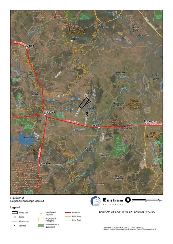
IDEMITSU AUSTRALIA RESOURCES

Impacts on scenic amenity and lighting typically extend well beyond the Project Site. Therefore, the
assessment considers a wider area around the Project, comprising land forming the landscape context and
within the potential viewshed of the Project, extending up to around 10 km from the Project Site, defined as
the LVIA study area (study area).
It should be noted that the current mains ventilation system will be utilised to manage incidental gas for the
Project. The current surface infrastructure is deemed to be sufficient for ventilation requirements so no new
infrastructure will be required within Zone 1. Seam gas pre-drainage be required to manage gas emissions in
the underground workings then an underground in-seam method is proposed to be used. Gas from this
underground collection system has been designed to exit the underground in Zone 2 and Zone 3 to be flared
to reduce greenhouse gas emissions. Zone 2 and Zone 3 is largely disturbed with large areas of cleared land.
The flaring infrastructure will require an exclusion zone of up to 80 m by 20 m on disturbed land which would
not require vegetation clearing (other than maintenance of grass levels to minimise any fire risk) and would
utilize existing tracks on existing mining leases for access. Flaring infrastructure will be approximately 8 m in
height with the flare up to 3 m in height on top of the infrastructure and will operate continuously.

24.2         Legislation and policy
This section summarises the key planning designations, policies and guidance relating to scenic amenity and
lighting within the Project Site and wider study area, defined as an area up to around 10 kilometres (km) from
the Project Site (and described further in Section 24.3.1). The emphasis is to identify landscape and visual
amenity objectives and development objectives as described in planning schemes or strategic plans that are
relevant to the Project. Some policies may have an indirect influence on landscape and visual character, for
example policies with environmental or ecological objectives (e.g. rehabilitation or revegetation works).
The relevant designations, policies and guidelines are discussed in the following sections and, where relevant,
shown on Figure 24-1. The discussion of relevance to the current assessment considers the following key
issues:
·    whether the purpose of the policy is related to the protection/management/direction of scenic amenity of
     lighting values within the study area
·    the level of policy importance i.e. at the Commonwealth, State or local level
·    if the Project has potential to theoretically directly or indirectly affect those landscape/visual values for
     which it is protected – depending on the nature of the specific values this may be affected by factors
     such as proximity, the presence of intervening landform that may restrict inter-visibility, probable levels
     of recreation use etc.
Whether a designation falls inside or outside of the Project Site is not of primary relevance to the consideration
of potential for landscape/visual impacts since the visibility of Project components may extend considerably
beyond this boundary.
No specific Commonwealth or Queensland legislation applies to scenic amenity or lighting values of the Project
Site or the wider area around the Project Site.
The Project is not assessable against any regional or local planning schemes. However, consideration has
been made of any landscape and scenic amenity provisions within the applicable Regional and Local Plans
as described in Section 24.2.1 and Section 24.2.2.

                                                                                                              24-2
ENSHAM LIFE OF MINE EXTENSION PROJECT ENVIRONMENTAL IMPACT STATEMENT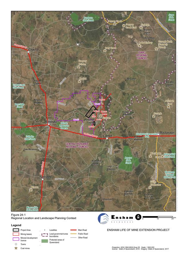
IDEMITSU AUSTRALIA RESOURCES

24.2.1      Regional planning schemes
The Central Queensland Regional Plan (DSDIP, 2013) is the regional plan which guides future planning
decisions across the region. The plan includes general guidance on the protection of landscape values in the
region as described in Section 24.2.2. Due to the close proximity of the Project to the Isaac Region, the
Mackay, Isaac and Whitsunday Regional Plan (2012) has also been included to ensure consistency across
the study area for the scenic amenity and lighting assessment and is also described in Section 24.2.2.

                                                                                                        24-3
ENSHAM LIFE OF MINE EXTENSION PROJECT ENVIRONMENTAL IMPACT STATEMENT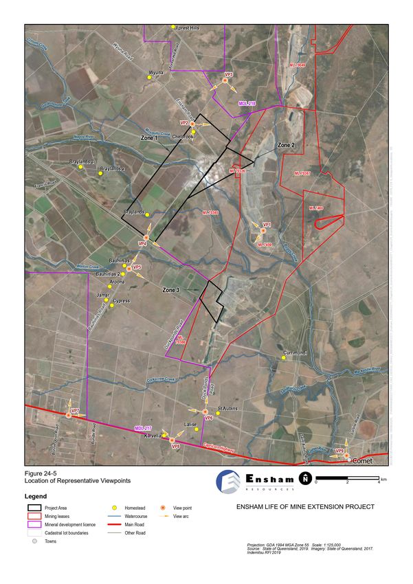
IDEMITSU AUSTRALIA RESOURCES

Table 24-1 Regional landscape planning policy context

 Central Queensland Regional Plan (2013)

 The Project is located in the Central Queensland Regional Plan area (within the area of the Central Highlands
 Regional Council (CHRC)).

 Policy objective                                       Purpose/intent

 Chapter 6 – Other state interests

 Economic growth - tourism                              The plan states that “…As areas of high scenic or natural
                                                        amenity are the region’s most significant drawcard,
                                                        managing potential tourism sector impacts on
                                                        environmental values is necessary to ensure a long term
                                                        sustainable tourism industry in the region. Coastal and
                                                        island environments provide an opportunity for expanded
                                                        tourism activities and accommodation, but also a challenge
                                                        to sensitively plan for developments that provide for
                                                        appropriate avoidance and mitigation of environmental
                                                        impacts.”

 Mackay, Isaac and Whitsunday Regional Plan (2012)

 The Mackay, Isaac and Whitsunday Regional Plan applies to areas to the west of the Project (within the area of
 Isaac Regional Council). The Strategic Direction acknowledges the diversity of landscapes across the region
 including ‘the western coalfields around Moranbah, Dysart and Nebo’ and states that ‘these landscapes are the
 basis of the social, economic, tourism and cultural values of the region’.

 Policy objective                                       Purpose/intent

 Regional landscapes

 Desired regional outcome (DRO) 2 Regional              The purpose of this policy is to protect regional landscape
 Landscapes: Environmental, economic, social and        values. The plan states that ‘to remain attractive and
 cultural values of the regional landscape are          functional, the regional landscape must be responsibly
 identified and secured to meet community needs and     planned and well managed to continue to support values
 achieve ecological sustainability.                     including biodiversity, rural production, scenic amenity,
                                                        landscape heritage and outdoor recreation’.
                                                        The notes associated with DRO2 2.2 identify that each
                                                        component of the regional landscape has its own specific
                                                        value and significance to the environment and residents of
                                                        the region including: natural economic resource areas –
                                                        sections of the landscape that support agricultural
                                                        production, extractive industry, forestry, tourism and rural
                                                        industries.

24.2.2        Local planning schemes
At the local level, the Project is located within the Central Highlands Regional Council (CHRC) Local
Government Area (LGA), as shown on Figure 24-1. Therefore, relevant provisions of the Central Highlands
Regional Council Planning Scheme (2016) are described in Table 24-2.

                                                                                                                  24-5
ENSHAM LIFE OF MINE EXTENSION PROJECT ENVIRONMENTAL IMPACT STATEMENT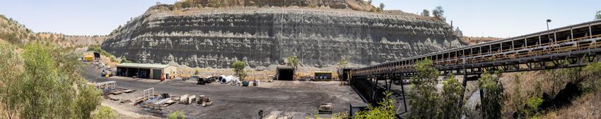
IDEMITSU AUSTRALIA RESOURCES

Due to the proximity of the Project to the Isaac Regional Council (IRC) LGA, the relevant provisions of the
Proposed Isaac Regional Planning Scheme (2018) and the existing Broadsound Planning Scheme (2005) (in
effect until the new planning scheme covering the Isaac region is adopted) are also considered and described
in Table 24-2.

Table 24-2 Local landscape planning policy context

 Central Highlands Regional Council Planning Scheme (2016)

 The Project is situated within the CHRC LGA.
 The Central Highlands Planning Scheme 2016 (Amendment No. 3) came into effect on 15 September 2017.
 Part 3 Strategic framework, 3.2 Strategic intent states:
 “Natural environments in the Central Highlands are conserved in perpetuity in a well-planned, coordinated and
 regulated network of green space that excludes incompatible development and maintains the integrity of
 natural values. The region also contains an abundance of natural resources and landscape features that are
 well managed, utilised and protected. These resources support the region’s unique character and enable
 economic development through the sustainable use of mineral and agricultural assets.”

 Policy objective                    Purpose/intent

 3.3 Settlement pattern theme

 3.3.4 Element 3 – Network of        All land within the Central Highlands has been categorised into a ‘Place’ type,
 centres and places (Central         each of which has its own specific strategic planning outcome that is sought for
 Highlands place model)              its character, land use and development. The Project falls within the area
                                     identified as ‘Rural Place’ on Strategic Framework Map SFM-001a.
 3.3.4.2 Specific outcomes – Rural
 Places                            The following specific outcomes for Rural places are relevant to landscape
                                   and/or visual amenity:
                                     “(e) Rural Places contribute to the landscape setting of the Central Highlands
                                     and its urban communities located in other place types...”

 3.5. Natural resources and landscape theme

 3.5.1 Strategic Outcomes            The strategic outcomes for the natural resources and landscape theme include
                                     the following provisions relevant to scenic amenity:
                                     ·   (a) The scenic amenity values of natural and rural landscapes within the
                                         Central Highlands are protected, maintained and enhanced for current and
                                         future generations, including Carnarvon Gorge, Sandstone Belt and Gorges,
                                         Expedition Ranges, Blackdown Tablelands, Bedford Weir, Peak Downs
                                         district and Mount Zamia.
                                     ·   (b) Natural and rural landscape features are appropriately managed, utilised
                                         and protected to ensure that the Central Highlands maintains its unique
                                         character and identity whilst also allowing its natural resources, such as
                                         mineral and agricultural assets, to be sustainably used and managed.

                                                                                                                      24-6
ENSHAM LIFE OF MINE EXTENSION PROJECT ENVIRONMENTAL IMPACT STATEMENT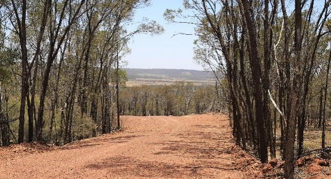
IDEMITSU AUSTRALIA RESOURCES

 Central Highlands Regional Council Planning Scheme (2016)

 3.5.2. Element 1 – Scenic         The plan seeks to ensure that:
 Amenity Specific outcomes
                                    ·   (a) Areas having high scenic amenity value are protected from land use and
                                        development with the potential to cause significant adverse visual or other
                                        impacts on natural landscape values.
                                    ·   (b) Natural areas of high scenic amenity value are sustainably managed
                                        within the region and include:
                                        –     (i) rich, fertile soil for agricultural activity;
                                        –    (ii) waterways, wetlands and water bodies; and
                                        –    (iii) vegetated landscapes including National Parks, State Forests,
                                             open space reserves, riparian corridors and remnant vegetation
                                             communities on private and public land.
                                    ·   (c) Significant intrusions on natural landscape values or resources, such as
                                        urban development and extractive industry are designed, located and
                                        operated to mitigate and reduce any negative impacts on scenic character
                                        and amenity.
                                   It is noted that there is no specific scenic amenity overlay or map that identifies
                                   specific areas of high scenic amenity value within the CHRC LGA.

 3.5.3 Element 2 – Natural resource management

 Mineral and extractive resources The plan seeks to ensure that:
                                   (b) Extractive industry activities not located within a key resource area “(ii) are
                                   located, designed and operated to protect and maintain the amenity and
                                   environmental values of surrounding development.”

 6.2.16 Rural zone code

 Planning Scheme Regional Zone     The purpose of the rural zone code is to provide for rural uses and provide
 Map ZM002a of the Central         opportunities for non-rural uses that are compatible with agriculture, the
 Highlands Regional Council        environmental features, and landscape character of the rural area. The purpose
 Planning Scheme shows that the    of the rural zone code will be achieved through the following overall outcomes:
 Project Site and its immediate
 context falls within the Rural     ·   (a) development provides for a broad range of rural uses… Extractive
 Zone.                                  industry and more intensive rural uses…may also be established in the zone
                                        provided that adverse environmental and amenity impacts are avoided or
                                        appropriately managed…
                                    ·   (g) development for extractive industry uses are appropriately designed,
                                        operated and managed to avoid, or where avoidance is impractical,
                                        minimise significant nuisance and environmental impacts on surrounding
                                        premises.
                                    ·   (i) to maintain the rural character and amenity of the zone, development
                                        has a predominantly low-rise built form…
                                    ·   (j) the built form of development integrates with and complements the
                                        predominant rural character and scale of the zone, and sensitively responds
                                        to the environmental and topographical features of the landscape.

                                                                                                                     24-7
ENSHAM LIFE OF MINE EXTENSION PROJECT ENVIRONMENTAL IMPACT STATEMENT
IDEMITSU AUSTRALIA RESOURCES

 Proposed Isaac Regional Planning Scheme (2018)

 The proposed Isaac Regional Planning Scheme is in development, following a consultation period that
 occurred between July and September 2018.
 Part 3 Strategic framework, 3.2 Strategic intent states:
 “Rural areas support mining activities, renewable energy facilities, infrastructure and hazardous activities
 that cannot be located within urban areas in locations that do not impact upon surrounding sensitive land
 uses.”
 “Extractive industry operations occur within identified key resource areas or in rural areas where
 environmental impacts and impacts on infrastructure can be avoided or mitigated.”
 “Development and infrastructure mitigates impacts on cultural heritage, water quality and natural
 environmental values.”
 “The cumulative impacts of development in the region is managed to avoid intolerable or unacceptable
 health, safety and amenity impacts on residents and visitors to the region.”

 Policy objective                     Purpose/intent

 3.5. Protecting natural resources and the environment

 Extractive, mineral, gas and         The plan seeks to ensure that:
 petroleum resources (3.5.1.2)
                                      “(4) Extractive resource operations only occur where compatible with the
                                      intentions of the relevant zone and overlays applying to the site, and where
                                      impacts on visual amenity, the natural environment … or the safety and amenity
                                      of the surrounding area can be mitigated to an acceptable standard.”
                                      “(5) Extractive resource operations…are managed to avoid or mitigate to an
                                      acceptable standard, impacts including impacts on visual amenity...”

 6.2.6.5 Rural zone code

 Land in close proximity to the   The rural zone code seeks to provide for rural uses and activities and other uses
 Project is identified within the and activities that are compatible with existing and future rural uses and activities
 rural zone on zoning map ZM-1.3 and “(ii) the character and environmental features of the zone”.
 of the Draft Isaac Regional
 Council Planning Scheme.

 8.2 Use codes

 8.2.1 Extractive industry code       The purpose of the extractive industry code is to facilitate the optimum use of
                                      extractive resources in identified areas in the region; ensure extractive industry
                                      operations occur in a manner that “minimises impacts on amenity and the
                                      natural environment; and ensure rehabilitation occurs following extraction’” The
                                      code requires that “extractive industry activities are designed and managed to
                                      mitigate as far as possible, impacts on the site and surrounding area’s
                                      environmental value.” And “land disturbed by extractive industry activities is
                                      progressively rehabilitated to ensure the site is environmentally stable and
                                      capable of reuse.”

                                                                                                                       24-8
ENSHAM LIFE OF MINE EXTENSION PROJECT ENVIRONMENTAL IMPACT STATEMENT
IDEMITSU AUSTRALIA RESOURCES

    Broadsound Planning Scheme (2005)

    The Broadsound Planning Scheme applies to land within the Isaac Shire LGA to the north-east of the Project
    Site. It does not include any landscape or scenic amenity overlays.
    Land near the Project Site typically falls within the general rural preferred use area, parts of which are
    identified as good quality agricultural land (Map 11 of the Planning Scheme).
    Part 2 of the Planning Scheme identifies desired environmental outcomes (DEOs) for the region. The DEOs
    include provisions relevant to landscape and visual amenity, as outlined below.

    Policy objective                      Purpose/intent

    Maintenance of cultural, economic, physical and social well-being of people and communities

    This DEO seeks:                       The specific outcomes and probable solutions for amenity, community harmony
                                          and the sense of community are set out in Planning Scheme Table 4.1. The
    (l) areas and places of special
                                          Planning Scheme seeks to avoid adverse impacts on the countryside by
    aesthetic, architectural, cultural,
                                          ensuring that buildings and works are attractive and consistent with the scale
    historic, scientific, social or
                                          and design of buildings and works in the rural neighbourhood. This includes:
    spiritual significance and their
    values are conserved or               ·    a proposed 8.5 metres (m) maximum height of a building structure or
    enhanced                                   object above natural ground surface
    (n) adverse effects for scenic        ·    screening of outdoor storage areas for waste, machinery and other
    values in coastal areas,                   materials from view from the street by fencing and/or landscape
    bushland and the rural                ·    not placing ‘transportable buildings of a kind used at construction and
    countryside are minimised.                 mining sites, usually called ‘dongas’’ within a rural preferred use area
                                               where they are visible from a road, neighbouring property or vantage point
                                          ·    avoiding impacts on associated, adjoining or nearby residential uses
                                               through the location and design of facilities (no probable solution is
                                               suggested)
                                          ·    maintaining rural amenity (no probable solution is suggested)
                                          ·    screening extensive open ponds and buildings with vegetation, topography
                                               or through sufficient setback distance from roads (no probable solution is
                                               suggested).

24.2.3          Guidelines and standards
There are currently no mandated Commonwealth or State requirements relevant to this LVIA. Therefore, the
approach to the LVIA has been developed with reference to concepts in accepted guidelines and standards
from Australia and elsewhere, including:
·      Guidance Note for Landscape and Visual Assessment (Australian Institute of Landscape Architects
       (AILA), 2018)
·      Guidelines for Landscape and Visual Impact Assessment, Third Edition (The Landscape Institute and
       the Institute of Environmental Management and Assessment, UK, 2013) and Second Edition
       (The Landscape Institute and the Institute of Environmental Management and Assessment, UK, 2002)
·      Australian Standard 4282 (1997) Control of Obtrusive Effects of Outdoor Lighting

                                                                                                                        24-9
ENSHAM LIFE OF MINE EXTENSION PROJECT ENVIRONMENTAL IMPACT STATEMENT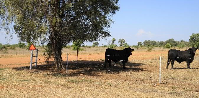
IDEMITSU AUSTRALIA RESOURCES
· Visual Landscape Planning in Western Australia: a manual for evaluation, assessment, siting and
design (Western Australian Planning Commission and Department for Planning and Infrastructure,
2007)
· Technical Guidance Note 06/19: Visual Representation of Development Proposals (The Landscape
Institute, UK, 17 September 2019)
· Topic Paper 6: Techniques and Criteria for Judging Capacity and Sensitivity (Scottish Natural Heritage
and The Countryside Agency, UK, 2006).
24.3 Methodology
24.3.1 Desktop assessment
A preliminary desktop analysis was undertaken to determine existing scenic amenity values within the Project
Site, as well as within the wider landscape around Ensham Mine. This included analysis of the underlying
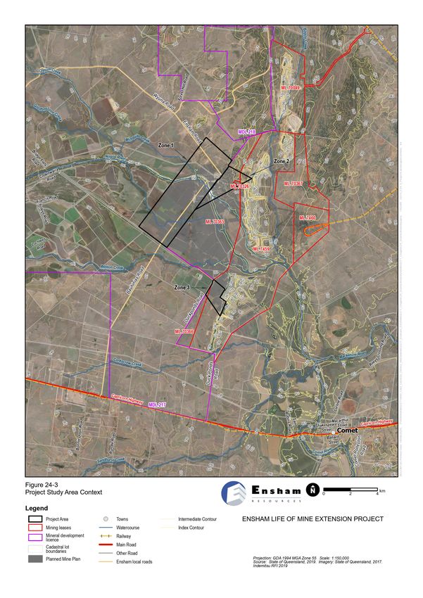
topography, land cover and landscape values. The assessment considered a wider area around the Project,
defined as the LVIA study area as shown in Figure 24-3.
Key information sources have been identified and reviewed as a component of the desktop analysis. These
sources include:
· relevant planning schemes, policies and guidelines from local councils (as described in Section 24.2)
· cadastral data (showing roads, property boundaries and built areas)
· Queensland Globe data
· digital aerial photography (imagery dated 2018 from Google Earth)
· Queensland bioregion data
· publicly available information on recreation spaces and public visitor areas
· existing infrastructure.
24.3.2 Identification of potential impacts
This component of the assessment includes consideration of any above-ground infrastructure and imagery
that may be associated with the Project. The potential components and their impacts are further discussed in
Section 24.5.
24.3.3 Field survey
A field visit was carried out on 18 November 2019, during which time photographs were obtained for the
purposes of the scenic amenity and lighting assessment. The field survey was undertaken by a Landscape
Planner with experience of LVIA accompanied by an Ensham Resources Environmental Advisor with
knowledge of the Project Site and surrounding landscape. The field survey was used to ground truth the
findings of the desktop assessment and to undertake an on-site assessment of scenic amenity values and
potential impacts.
24-10
ENSHAM LIFE OF MINE EXTENSION PROJECT ENVIRONMENTAL IMPACT STATEMENTIDEMITSU AUSTRALIA RESOURCES
Photographs were taken to portray landscape character and inform the viewpoint assessment from
representative viewpoints. To ensure the photomontages consistently present a view which is representative
of the human eye, the field assessment photographs were taken at average human viewing height (typically
considered to be 1.5 - 1.7 m). The photos were taken using a Canon EOS 6D Mark II body with a Sigma
50 millimetre (mm )f/1.4 DG JSM lens. The Canon EOS 6D is a full sensor lens. Using a 50 mm lens it has an
equivalent field of view as a standard single lens reflex (SLR) using 35 mm film and 50 mm focal length, which
is the standard (albeit technologically outdated) recommendation for obtaining photographs that are
representative of the human field of vision (40 degrees).
Photo stitching software and Adobe Photoshop were used to piece together the adjoining images to produce
a field of vision of approximately 75° that is considered representative of the human field of view. Although the
parameters of human vision when stationary is often quoted as falling between the 45-60° (SNH, 2006),
humans generally move their eyes, heads and bodies as necessary to experience a view. Therefore, a wider
field of view has been used for the photomontages, which is in line with good practice.
24.3.4 Scenic amenity assessment
“An assessment of visual effects deals with the effects of change and development on the views available to
people and their visual amenity. The concern here is with assessing how the surroundings of individuals or
groups of people may be specifically affected by changes in the content and character of views as a result of
the change or loss of existing elements of the landscape and/or introduction of new elements” (Landscape
Institute and Institute of Environmental Management and Assessment, 2013)
Visual receptor audiences are assessed and described in terms of the views that can be obtained from selected
representative viewpoints within the study area. Representative viewpoints have been identified and described
as part of the assessment. Visual receptors have been identified based on a number of parameters, including:
· proximity of the receptor to the Project Site
· type of visual receptor experiencing the view e.g. residents, people passing through the area in
vehicles, recreational users or workers.
These visual receptor audiences and representative viewpoints are discussed further in Section 24.5.
24.3.4.1 Visual sensitivity
For the purposes of this assessment, the sensitivity of the viewers at the viewpoints is considered to be
dependent upon:
· the importance of the view i.e. the scenic qualities of the view, including the presence of other existing
manmade elements in the view
· the nature of the visual receptor (type and volume of sensitive receptors or viewers) experiencing the
view; for example, residents and visitors to important/valued landscapes are considered to have a
higher sensitivity to their visual environment than, say, visitors to non-designated areas or motorists
passing through the landscape.
Viewpoint sensitivity is defined in Table 24-3.
24-11
ENSHAM LIFE OF MINE EXTENSION PROJECT ENVIRONMENTAL IMPACT STATEMENTIDEMITSU AUSTRALIA RESOURCES
Table 24-3 Defining visual sensitivity
Attributes of viewpoint sensitivity categories Viewpoint sensitivity
Large numbers of viewers, particularly those with proprietary interest and prolonged High
viewing opportunities such as residents and users of attractive and/or well-used
recreational facilities. Views from a regionally important location such as a scenic lookout
whose interest is specifically focussed on the landscape.
Medium numbers of residents and moderate numbers of visitors with an interest in their Medium
environment e.g., visitors to State Forests, including bush walkers, horse riders, trail bikers.
Larger numbers of travellers with an interest in their surroundings.
Small numbers of people and/or those with a passing interest in their surroundings e.g., Low
those travelling along principal roads. Viewers whose interest is not specifically focussed
on the landscape e.g. workers, commuters.
Very occasional numbers of viewers with a passing interest in their surroundings e.g. those Negligible
travelling along minor roads or views from the air
24.3.4.2 Magnitude of change to visual amenity from representative viewpoints
The magnitude of change to views and visual amenity depends on the nature, scale and duration of the change
that is expected to occur. The magnitude of change also depends on the loss, change or addition of any feature
in the field of view of the receptor; or any change to the backdrop to, or outlook from, a viewpoint. The
assessment assumes a worst case scenario without mitigation. The level of effects on a view depend on the
extent of visibility, degree of obstruction of existing features, degree of contrast with the existing view, angle
of view, duration of view and distance from the Project.
Magnitude of change is described as being barely perceptible, noticeable, considerable or dominant, as
illustrated in Table 24-4. Full descriptions on the magnitude of change from each representative viewpoint are
discussed further in Section 24.5 below.
Table 24-4 Defining magnitude of change to scenic amenity
Attributes of magnitude of change categories Magnitude of change
Dominant change: major changes in view at close distances (typically less than 100 m), High
affecting a substantial part of the view, continuously visible for a long duration, or
obstructing a substantial part or important elements of view and introducing new and
incongruous elements into the view.
Considerable change: clearly perceptible changes in views at intermediate distances Medium
(typically 100 – 500 m), resulting in either a distinct new element in a significant part of the
view, or a wider ranging, less concentrated change across a wider area.
Noticeable change: minor changes in views, at long distances (typically 500 m – 1 km) or Low
visible for a short duration, and/or are expected to blend in with the existing view to a
moderate extent.
24-12
ENSHAM LIFE OF MINE EXTENSION PROJECT ENVIRONMENTAL IMPACT STATEMENTIDEMITSU AUSTRALIA RESOURCES
Attributes of magnitude of change categories Magnitude of change
Barely perceptible change: change which is barely visible, at a very long distance Negligible
(typically more than 1 km), or visible for a very short duration, and/or are expected to blend
with the existing view.
Imperceptible change: Change which cannot be discerned either due to lack of new No impact
elements or such minor changes that due to distance they change is unlikely to be
registered by the viewer.
24.3.4.3 Overall significance of impact on scenic amenity from representative viewpoints
The evaluation of overall potential impacts on visual amenity is based on the sensitivity of existing views to
change and the magnitude of change that is likely to occur. No prescribed methods to assess significance of
impacts exist. Therefore, professional judgement and experience are applied to identify the level of
significance. Each viewpoint is assessed on its own merits, as factors unique to each circumstance need to
be considered. However, there are general principles that can be used as a guide to this process which
provides transparency about how judgements have been made. The overall significance of change to visual
amenity and individual viewpoints, is determined by using Table 24-5, and presented in Section 0.
Table 24-5 Determining significance of effect on scenic amenity
Significance of Magnitude of change in views*
impact
Medium Negligible
High Low
(considerable (barely perceptible
(dominant change) (noticeable change)
change) change)
High Major Moderate to major Moderate Minor to moderate
Sensitivity of views
Medium Moderate to major Moderate Minor to moderate Minor
Low Moderate Minor to moderate Minor Minor to negligible
Negligible Minor to moderate Minor Minor to negligible Negligible
*Note: where ‘no impact’ is recorded for the magnitude of change, the significance of impact is recorded as ‘no impact’.
24.3.5 Lighting impact assessment
A detailed assessment of lighting impact (in accordance with AS 4282) has not been undertaken because
there are no additional proposed permanent light sources. All permanent light sources associated with the
Project are existing or would be located underground so would not be visible to receptors or affect amenity
values. The proposed flares are a potential source of light spill. However, there are no Australian standards
specifically for night flaring. The lighting impact assessment presented is a qualitative assessment of impacts
at night based on the same sensitivity and magnitude criteria as the daytime assessment.
24-13
ENSHAM LIFE OF MINE EXTENSION PROJECT ENVIRONMENTAL IMPACT STATEMENTIDEMITSU AUSTRALIA RESOURCES
24.4 Description of environmental values
This section provides an overview of the landscape and visual character of the existing regional and local
context of the Project.
24.4.1 Regional landscape context
24.4.1.1 Settlement and infrastructure
As shown on Figure 24-1, the Project Site is situated approximately 35 km east of Emerald in the western part
of the central Bowen Basin, within an area dominated by rural land uses, in particular cattle grazing, dry land
cropping and irrigated cropping (within the Emerald irrigation area). As shown on Figure 24-1 several coal
mines are located across the region. The surrounding landscape comprises isolated farmsteads and
associated agricultural infrastructure such as sheds and barns, while there is also considerable evidence of
mining activity including the existing open cut mines and associated surface infrastructure. Electricity
transmission lines and coal freight railways are associated with the mining areas.
Emerald has a population of 14,356 (ABS, 2019) and is a regional centre servicing the surrounding region and
was originally established to facilitate the construction of the western railway (CHQ, 2019). It is serviced by a
regional airport.
Blackwater, established in 1886 to provide services for rail workers and farmers (BICC, 2019), has developed
into an important coal mining town with a population of 4,749 (ABS, 2019) and is home to the Blackwater
International Coal Centre and the Australian Coal Mining Museum.
The small town of Comet, shown on Figure 24-2 is situated at the junction of the Nogoa, Mackenzie and Comet
Rivers approximately 18 km to the south-east of the Project Site, and is one of the earliest townships in the
region with a population of 498 (ABS, 2019).
These settlements are connected by the Capricorn Highway, which is located to the south of the Project Site
and connects Barcaldine in the west to Rockhampton in the east. The section between Duaringa and Emerald
in the vicinity of Duckponds Road (TMR Chainage 127.950 km) has an annual average daily traffic (AADT)
count of up to 1,429 vehicles (around 15.65 per cent of which are heavy vehicles). Other key roads within the
vicinity of the Project Site include the Gregory Highway and Blackwater Rolleston Road with AADTs of 2,653
and 1,855 respectively. Other local roads around the Project Site are typically sealed and unsealed public
roads with low daily traffic counts, or unsealed tracks accessing private properties.
An existing freight rail track services the Ensham Mine and other surrounding coal mines, transporting coal to
the Port of Gladstone. This is part of the Blackwater coal system, which forms part of the Central Queensland
Coal Network operated by Aurizon (Aurizon, 2019).
24.4.1.2 Landform and hydrology
The main hydrological and topographical features of the landscape are illustrated in Figure 24-2 with more
detail around the Project Site provided in Figure 24-3 and Figure 24-4.
The main watercourses comprise the Nogoa, Mackenzie and Comet rivers and Theresa Creek, which are all
major waterways within the Fitzroy Basin. The Nogoa River and its minor tributaries traverse the Project Site
and provide water supply from Fairbairn Dam (Lake Maraboon) to downstream users. The Fairbairn Dam is
located 19 km south-west of Emerald and provides public facilities including a boat ramp, amenities, picnic
tables and barbeques, while camping is available at the nearby Lake Maraboon Holiday Park (DAF, 2018).
24-14
ENSHAM LIFE OF MINE EXTENSION PROJECT ENVIRONMENTAL IMPACT STATEMENTIDEMITSU AUSTRALIA RESOURCES
The region surrounding the Project Site is dominated by low-lying, relatively flat to gently undulating
landscapes between 120 m and 300 m above Australian height datum (AHD) from which low hills, mountains
and tablelands arise, including local peaks such as Mount Crocker (248 m AHD) approximately 18 km to the
east of the Project Site. Within the broader region Mount Gobula (251 m AHD), Mount Sirloin (392 m AHD)
and landscapes associated with the Minerva Hills, Shotover Range, Expedition Range (including Mount
Success (790 m AHD)) and the Dawson Range are found.
24.4.1.3 Vegetation character and recreational land use
There are no protected landscapes close to the Project Site or other areas that are likely to be used for
recreation.
As shown on Figure 24-1, the closest National Park is Blackdown Tableland National Park, which is situated
within the wider landscape context of the area and includes a variety of recreation opportunities, amenities,
camping facilities and several elevated scenic lookouts. Ghungadu Conservation Park and Arthurs Bluff State
Forest are situated nearby the Blackdown Tableland National Park, however have no formal recreation
facilities. These areas are too distant to be affected by the Project.
The nearest State Forest is Amaroo State Forest which is located approximately 23 km south-east of the
Project Site, while Fairbairn State Forest and Belmah Resource Reserve are situated approximately 35 km
and 15 km respectively to the south-west of the Project Site. No formal recreation facilities are provided at any
of these locations.
With the exception of more elevated, undulating areas (typically associated with areas within state forest and
national park), vegetation has largely been cleared within the study area to facilitate rural land uses. Remnant
vegetation is typically comprised of open forests and woodlands dominated by Brigalow (Acacia harpophylla)
and Coolibah (Eucalyptus coolabah), which occurs in locally elevated areas and along riparian corridors (DES,
2019), and tree belts associated with edge of local and state roads.
24.4.1.4 Landscape character including the Interim Biogeographic Regionalisation for Australia
The Interim Biogeographic Regionalisation for Australia (IBRA) is a biogeographic regionalisation of Australia
developed by the Australian Government department formerly known as Department of Sustainability,
Environment, Water, Population and Communities (now Department of Agriculture, Water and the Environment
(DAWE)). IBRA represents a landscape-based approach to classifying the land surface of Australia. The IBRA
data consists of two datasets: IBRA bioregions, which are a larger scale regional classification of homogenous
ecosystems; and sub regions, which are more localised.
Whilst bioregions have been defined mainly for the purposes of ecosystem planning and monitoring, the
nominal attributes that make up IBRA are: climate, lithology/geology, landform, vegetation, flora and fauna and
land use which are themes typically used to define landscape character at a high level. On 5th July 2012, IBRA
7.0 was released, which delineates 89 biogeographic regions and 419 sub regions, each reflecting a unifying
set of major environmental influences which shape the occurrence of flora and fauna and their interaction with
the physical environment across Australia. The bioregion information enables a high-level desktop
understanding of the different landscape settings of the study area. The descriptions for the sub-regions that
accompany IBRA7 are not currently published. However, upon request, the Queensland Government
Environmental Resources Information Network (ERIN) supplied descriptions of each of the sub-bioregions in
the study area for the IBRA5.1 dataset (which follows similar boundaries).
The Project Site falls within the Brigalow Belt North (BBN) Bioregion. Most of Mineral Development Licence
(MDL) 217 and the entirety of the Project Site falls within the BBN11 Isaac-Comet Downs Subregion. The area
to the north-west and south-west of the Project Site falls within the BBN10 Basalt Downs Subregion. These
are shown on Figure 24-2 (ERIN, 2012) and described in Table 24-6 below.
24-15
ENSHAM LIFE OF MINE EXTENSION PROJECT ENVIRONMENTAL IMPACT STATEMENTIDEMITSU AUSTRALIA RESOURCES
Table 24-6 IBRA subregion descriptions
IBRA subregion Description
name, code and
total area
(hectares)
Basalt Downs Basalt Downs is formed almost entirely on Tertiary basalts. It occurs as two separate parts:
a northern section, which is dominantly undulating and contains areas of lower Tertiary
BBN10
sediments; and a southern section which is predominantly hilly and contains areas of
1,238,537 outcrop of Permian sediments. The more undulating areas carry a blue grass (Dichanthium
sericeum) grassland with mountain coolibah (Eucalyptus orgadophila) on hillier areas, often
with silver–leaved ironbark (E. melanophloia) and red bloodwood (Corymbia erythrophloia).
coolibah (Eucalyptus coolabah) occurs on flood plains. In the north, on Tertiary weathered
basalts, gidgee (Acacia cambagei) scrub and brigalow (A. harpophylla) scrub are common,
belah (Casuarina cristata) often occurring with the latter. Narrow-leaved ironbark
(Eucalyptus crebra) forms woodlands with silver-leaved ironbark (E. melanophloia) and red
bloodwood (C. erythrophloia) on rugged basalt areas. On the Permian sediments narrow-
leaved ironbark or poplar box (Eucalyptus populnea) form open or shrub woodlands.
Isaac-Comet Downs Isaac-Comet Downs is an extensive but diverse subregion that does not readily lend itself
to further subdivision. It is a largely undulating subregion dominated by Tertiary and other
BBN11
Cainozoic deposits, with mid-catena deposits being slightly more prominent. Tablelands
2,701,119 and dissected remnants of the upper Tertiary surface are widespread, carrying a narrow-
leaved (Eucalyptus crebra) woodland on the earths of undulating plateaus, and bendee
(Acacia catenulata) or lancewood (A. shirleyi) on the rocky hills and mesas. The lower parts
of the Tertiary surface are dominated by Brigalow (Acacia harpophylla) and Dawson gum
(Eucalyptus cambageana) — brigalow communities on undulating clay or tenure contrast
soils. These communities dominate the subregion. Alluvium is also prominent, and the
predominantly fine textured soils carry brigalow or open woodland of coolibah (Eucalyptus
coolabah). Fine grained Permian sediments are exposed in some areas, giving rise to
grasslands, open woodland and areas of brigalow.
The key landscape character types identified around the Project Site comprise:
· irrigated croplands (predominantly cotton and chick peas)
· dry croplands
· dryland grazing (predominantly beef cattle)
· transitional landscape (including coal mines).
The character of these landscape types is illustrated on Plate 24-1.
24.4.2 Project Site landscape
The Project Site, as shown on Figure 24-3 is located immediately adjacent or close to areas affected by the
existing Ensham Mine, which is a large open cut and underground coal mine operated by the partners of
Ensham Joint Venture (Ensham JV) on Mining Lease (ML) 7459, ML 7460, ML 70049, ML 70326, ML 70365,
ML 70366 and ML 70367 under Environmental Authority (EA) EPML00732813. Ensham JV also holds the
adjacent MDL 217 and MDL 218. There are a number of other petroleum tenements overlapping the Project
Site.
The existing Ensham Mine comprises underground workings as well as a large area of open cut operations at
various stages of its lifecycle including:
24-19
ENSHAM LIFE OF MINE EXTENSION PROJECT ENVIRONMENTAL IMPACT STATEMENTIDEMITSU AUSTRALIA RESOURCES
· fully rehabilitated areas
· areas currently undergoing active rehabilitation (including fill and grading operations)
· areas of open cut mine that are currently being actively excavated using dragline excavators
· active underground mine operations.
The exiting mine is supported by typical mining infrastructure associated with the processing and transport of
coal from the mine to market. These are discussed further in Section 24.5.
The Project Site, shown on Figure 24-5 , comprises largely flat to gently undulating grazing lands and
irrigated croplands associated with the Nogoa River and its tributaries, typically between around 150 m AHD
and around 180 m AHD. The Project Site is divided into three zones:
· Zone 1: this is the largest zone, comprising farmland associated with the Nogoa River that runs through
this zone. It includes the properties known as Braylands and Chelbrook, accessed via private tracks from
Bauhinias Road and Ensham Road respectively.
· Zone 2: this comprises farmland associated with the Nogoa River located in the south of this zone. It
occupies land between Zone 1 and the existing open cut mine area. No properties or roads are located
in this zone and the nearest property is Chelbrook.
· Zone 3: this comprises farmland associated with a tributary of the Nogoa River, located to the west of the
existing open cut mine. There are no properties located within this zone.
24-20
ENSHAM LIFE OF MINE EXTENSION PROJECT ENVIRONMENTAL IMPACT STATEMENTIDEMITSU AUSTRALIA RESOURCES
Project Site context: rural roads and distant hills beyond Project Site Project Site context: Nogoa River (within the existing Ensham Mine
area)
Project Site context: Capricorn Highway and irrigated croplands Project Site context: dryland grazing within the Study Area
Project Site context: character of Comet township Project Site character: irrigated croplands
Project Site character: decommissioned drag line excavator Project Site character: existing underground coal mine portal
Plate 24-1 Images illustrating landscape and visual character of the study area
24-21
ENSHAM LIFE OF MINE EXTENSION PROJECT ENVIRONMENTAL IMPACT STATEMENTIDEMITSU AUSTRALIA RESOURCES
24.5 Potential Impacts
24.5.1 Potential surface mine components
This section describes the key components of the Project that are relevant to the assessment of impacts on
scenic amenity and lighting. For further details on the description of the Project, refer to Chapter 4 (Project
description and alternatives). Table 24-7 describes the features of Ensham Mine, noting where existing
infrastructure will be used for the Project and, as appropriate, providing an example of the appearance of
typical existing mine components.
Key issues of relevance to potential landscape and visual impacts are:
· subsidence is not predicted to be significant due to the bord and pillar mining method and design that is
proposed
· flaring infrastructure will be required for the Project to maintain a safe air quality for workers and mitigate
greenhouse gas emissions
· existing surface infrastructure (including CHP) associated with the current operation of Ensham Mine
has sufficient capacity to accommodate the extension of mining operations into the Project Site
· the current workforce accommodation arrangements will continue and no new accommodation facilities
are required
· all new lighting infrastructure will be underground so no additional light spill is anticipated to be visible
on the surface except for light created by flaring
· Waste rock will be buried in the open cut pits as part of the rehabilitation process.
Table 24-7 Potential Project impacts on scenic amenity and lighting
Development activities and infrastructure Imagery
Removal of vegetation – none proposed
As this is an underground mine site and as no
additional surface infrastructure is required,
activities such as the clearance of vegetation
is not required.
Flaring infrastructure would require an
exclusion zone of up to 80 m by 20 m on
disturbed land which would not require
vegetation clearing (other than maintenance of
grass levels to minimise any fire risk) and
would utilize existing tracks on existing mining
leases for access. Flaring infrastructure would
be approximately 8 m in height with the flare
up to 3 m in height on top of the infrastructure
24-22
ENSHAM LIFE OF MINE EXTENSION PROJECT ENVIRONMENTAL IMPACT STATEMENTIDEMITSU AUSTRALIA RESOURCES
Development activities and infrastructure Imagery
Construction and operation of new haul roads
– no construction phase as part of Project and
no new routes required.
No new haul routes would be required as the
existing routes could continue to be used,
noting that the location of haul routes may
change as a result of ongoing activities in the
adjacent open cut mining areas.
Construction and operation of powerlines – No
construction phase as part of Project and no
new electricity transmission infrastructure is
required.
There are already plans to upgrade
transmission infrastructure with an 11 kilovolt
(kV) feed at the entrance to the current
underground mine (Ramp 5 substation). This
will be sufficient to supply the Project Site, so
no further infrastructure is anticipated to be
required.
Rail loop – no new rail infrastructure
proposed.
The existing rail spur and balloon loop will
continue to be used and no new rail
infrastructure is required.
Mine gas pre-drainage vents and flares –
flaring infrastructure on Zone 2 and Zone 3
Investigations have determined a need for
seam gas pre-drainage to manage gas
emissions in the underground workings, gas
from this underground collection system has
been designed to exit the underground in Zone
2 and Zone 3 will be flared.
Four flares will operate continuously on
existing mining leases: two flares will be
located in Zone 2 (ML 70326, ML 70365 and ML
7459) and two flares in Zone 3 (ML 7459 and
ML 70366). This is considered to be sufficient
for the purposes of draining any gas from the
proposed underground coal mine within the
Project Site. No infrastructure is proposed in
Zone 1 of the Project Site. Flaring stacks will
operate continuously and will be
24-23
ENSHAM LIFE OF MINE EXTENSION PROJECT ENVIRONMENTAL IMPACT STATEMENTIDEMITSU AUSTRALIA RESOURCES
Development activities and infrastructure Imagery
approximately 8 m tall with the flare height
being up to 3 m above the stack.
Accommodation facilities – no new facilities
required.
No new accommodation facilities
(Construction Village and/or Operations
Village would be required and the existing
camp would continue to be used).
Mine infrastructure area (MIA) – no new
facilities required.
The existing MIA will continue to be used for
the Project. This comprises buildings
including administration, operations,
communications, workshop and warehouse
buildings and car parks as well as
construction laydown and storage areas. No
new MIA will be required.
Coal handling plant (CHP)
The existing CHP comprises a truck dump
station, crushing and screening plant, product
conveyors, stackers, reclaim system and
loadout system. The CHP will be upgraded to
improve waste rock removal from the ROM
coal. The waste rock will continue to be
returned to the mining voids and used as fill.
ROM product stockpiles and conveyors – no
new facilities required
No new product stockpiles or conveyors
would be required as the Project will continue
to use the infrastructure and area associated
with the existing underground mine which
comprises non-static coal stockpiles up to
around 20 m in height that will continuously
change in form as mining progresses.
24-24
ENSHAM LIFE OF MINE EXTENSION PROJECT ENVIRONMENTAL IMPACT STATEMENTIDEMITSU AUSTRALIA RESOURCES
Development activities and infrastructure Imagery
Construction and operation of water
management infrastructure – no new facilities
required
The existing water management infrastructure
at Ensham Mine (see examples) will be
sufficient for the purposes of the Project and
no new surface infrastructure is required.
Topsoil and out of pit spoil disposal and
rehabilitation
Waste rock will be placed in existing open cut
spoil dumps. Over time these will be
progressively rehabilitated.
Rehabilitation will occur to the existing open
cut areas in accordance with the Ensham Mine
Rehabilitation Management Plan. This will
entail re-grading, planting and maintenance.
Rehabilitated landscapes will typically blend
more consistently into their wider landscape
setting than they would if left in a disturbed
state. However, the colours may be noticeably
different to that currently existing, at least in
the early years, due to the new growth of grass
seed and juvenile trees, which may stand out
as being somewhat greener than surrounding
pastures.
Predicted subsidence as a result of the Project
is less than the DAWE estimated seasonal
variation in surface levels as a result of
changes in moisture content (50 mm) and is
therefore unlikely to form surface cracks or
significant depressions in surface topography
where ponding of the surface water may occur.
Due to the bord and pillar method of excavation
proposed, it is not anticipated that any
unsupported strata (goaf) would collapse into
the mined void. Therefore, areas of subsidence
(typical of some underground mine projects)
24-25
ENSHAM LIFE OF MINE EXTENSION PROJECT ENVIRONMENTAL IMPACT STATEMENTIDEMITSU AUSTRALIA RESOURCES
Development activities and infrastructure Imagery
are not anticipated within the Project Site. This
is the method currently used for the existing
underground mine; the stability of the surface
is evident in the example image.
Project lighting – no additional surface lighting
proposed except for lighting caused by flaring
infrastructure
Lighting associated with the Project will be
underground and therefore will not be visible
to sensitive receptors. Surface lighting will
remain as per the mine operations at the time
of the assessment, except for lighting caused
by flaring infrastructure, which comprises
lighting of MIA, CHP and conveyors and the
accommodation village (necessary for safety,
security and mine operations). The image
shows an example of the night time lighting at
the time of the assessment.
24.5.2 Scenic amenity and lighting impact assessment overview
The LVIA for the Project has been undertaken by providing an assessment of the potential impact on the
existing view shed from selected key locations around the Project Site identified on Figure 24-5.
The scenic amenity and lighting assessment for each viewpoint is described in Table 24-8 to Table 24-16
below.
The selected views are as follows:
· Viewpoint 1: Existing underground mine portal looking south-west
· Viewpoint 2: ‘Chelbrook’ on Ensham Road looking south-east over the Project Site
· Viewpoint 3: Wyuna Road looking south
· Viewpoint 4: ‘Braylands’ on Bauhinias Road looking north-east over the Project Site
· Viewpoint 5: ‘Bauhinias’ on Bauhinias Road looking north-east
· Viewpoint 6: ‘St Aubins’ on Duckponds Road looking north-west
· Viewpoint 7: Capricorn Highway at Bonnie Doon Road looking north-east
· Viewpoint 8: Capricorn Highway near ‘Karvella’ looking north
· Viewpoint 9: MacArthur Street, Comet, looking north-west.
The assessment also considers the potential impacts of lighting upon each viewpoint identified in the scenic
amenity assessment. The assessment firstly describes the existing lighting conditions from the representative
viewpoints along with the location and proximity of the viewpoint to the lighting source to provide a baseline
against which the impacts of the Project can be extrapolated. As the Project activities will be primarily
undertaken underground, night lighting impacts on nearby receptors are anticipated to be limited, with the
exception of flaring in Zone 2 and Zone 3 (as described in Section 24.5).
24-26
ENSHAM LIFE OF MINE EXTENSION PROJECT ENVIRONMENTAL IMPACT STATEMENTIDEMITSU AUSTRALIA RESOURCES
24.5.3 Viewpoint 1: Existing underground mine portal looking south-west
Table 24-8 Likely visual effect of the Project on Viewpoint 1
Viewpoint 1 – Existing underground mine portal looking south-west
Visual baseline assessment
Location and · GPS Location: 23°28'23.489" S 148°29'34.511" E.
description
· Elevation: 105.5 m.
· View looking south-west from within the existing Ensham Mine area.
· Underground mine expansion area is around 5 km away at its closest point. However, the existing
portal will continue to be used for access to and transportation of coal from the expansion area.
· This view is not publicly accessible and is only visible to workers and approved visitors to Ensham
Mine.
· The landscape in this view comprises active mine workings associated with the existing
underground mine operations including the personnel and coal portal as well as hardstand,
workshops and conveyors transporting coal from the underground mine to stockpiles.
Scenic amenity (visual) evaluation
Sensitivity The overall sensitivity of receptors from this point is considered to be Negligible. This is due to the
viewpoint being accessible only to mine workers who would expect to see mine infrastructure which is
already present in the view.
Judgement of No change is anticipated in the view. Therefore, the magnitude of change to this viewpoint is
magnitude of considered to be ‘No impact’ due to the following factors:
change
· the underground mine infrastructure and supporting infrastructure is already present and will not
change as a result of the Project
· the mined coal will be visible to workers travelling on the conveyors, however, this is no change to
the existing scenario
· there are no changes anticipated to the 66 kV powerline visible beyond the rail line.
Judgement of No impact: due to the negligible sensitivity and ‘no impact’ for magnitude of change.
potential effect
Significance of Not significant: The effect of the Project on Viewpoint 1 is considered to be no impact and therefore
effect not significant.
24-28
ENSHAM LIFE OF MINE EXTENSION PROJECT ENVIRONMENTAL IMPACT STATEMENTYou can also read