3.9: Extreme Winter Weather Risk Assessment Hazard Description
←
→
Page content transcription
If your browser does not render page correctly, please read the page content below
3.9: Extreme Winter Weather Risk Assessment

Hazard Description
The National Weather Service defines a winter storm as having three factors: cold air, moisture and lift.
These three factors acting together create conditions suitable for a winter storm. Below are definitions for
winter weather events that could impact the Mississippi Gulf Coast:
Snow Flurries: Light snow falling for short durations. No accumulation or light dusting is all that is
expected.
Snow Showers: Snow falling at varying intensities for brief periods of time. Some accumulation is
possible.
Sleet: Rain drops that freeze into ice pellets before reaching the ground. Sleet usually bounces when
hitting a surface and does not stick to objects. However, it can accumulate like snow and cause a hazard
to motorists.
Freezing Rain: Rain that falls onto a surface with a temperature below freezing. This causes it to freeze
to surfaces, such as trees, cars, and roads, forming a coating or glaze of ice. Even small accumulations
of ice can cause a significant hazard.
Wind Chill: The combination of wind and temperature that serves as an estimate of how cold it actually
feels to exposed human skin. Wind chill values below -19 degrees are considered dangerous.
Winter Storm Warning: Issued when hazardous winter weather in the form of heavy snow, heavy
freezing rain, or heavy sleet is imminent or occurring. Winter Storm Warnings are usually issued 12 to 24
hours before the event is expected to begin.
Winter Storm Watch: Alerts the public to the possibility of a blizzard, heavy snow, heavy freezing rain, or
heavy sleet. Winter Storm Watches are usually issued 12 to 48 hours before the beginning of a Winter
Storm.
Winter Storm Outlook: Issued prior to a Winter Storm Watch. The Outlook is given when forecasters
believe winter storm conditions are possible and usually issued 3 to 5 days in advance of a winter storm.
Wind Chill Warning: Issued when wind chill temperatures are expected to be hazardous to life within
several minutes of exposure.
Wind Chill Advisory: Issued when wind chill temperatures are expected to be a significant
inconvenience to life with prolonged exposure and, if caution is not exercised, could lead to hazardous
exposure.
Winter Weather Advisories: Issued for accumulations of snow, freezing rain, freezing drizzle, and sleet
which will cause significant inconveniences and, if caution is not exercised, could lead to life-threatening
situations.
Winter storms in the south typically consist of light snow (snow flurries with little to no accumulation),
freezing rain (rain that falls when ground temperatures are below freezing), or sleet (transparently frozen
or partially frozen raindrops).

Hazard Profile
The hazard profile for extreme winter weather in Mississippi was updated from the previously approved
plan of 2013 to include current statistics regarding winter activity throughout the state.

Maximum Winter Storm Threat

Severe winter storms can cause immense economic losses to the state of Mississippi. Hampered
transportation routes caused by closed or blocked roads can prevent the movement of essential
economic goods by airports and waterways. An intense cold weather system during the winter of 1989 –
1990 brought about a widespread emergency in Central Mississippi. Unlike previous winter emergencies,
this crisis occurred because manufacturers and product brokers were unable to gain access to essential
transportation systems, such as pipelines, trucks and rail tankers that move heating fuel (propane). This
lack of fuel had a cascading effect on the domestic and manufacturing economies
Extreme winter weather in 2010 caused a similar disruption of the Central Mississippi economy.
According to the National Weather Service (NWS), the winter of 2009/2010 was characterized by below-
normal temperatures across the state of Mississippi. In Jackson, it was the fourth-coldest winter since
temperature records were first collected in 1896. It was also the ninth-snowiest winter in Jackson, with
one snowfall of 5.5 inches recorded by the NWS Forecast Office. In January, prolonged sub-freezing
temperatures caused massive failure of water mains throughout Jackson and the Central Mississippi
region, creating problems for residents and causing emergency conditions at hospitals, police precincts,
businesses, restaurants, communications systems and state facilities. (See a recap of this event under
the heading “Prolonged Sub- Freezing Temperatures – January 2010” in this section.)
Timber, a vital asset to the state’s economy, was severely impacted by the February 1994 ice storm
(FEMA- 1009-DR-MS). Damage to public facilities – coupled with $1.3 billion from timber losses –
resulted in one of the costliest disasters of this type the state ever experienced. Not only did the downed
timber create a problem from potential wildfires, but. collapsed roofs and downed power lines, resulted in
loss of heating, lighting, water and sewer systems.
Other secondary problems included flooding from melting ice and snow, and rainfall on heavily glazed
and saturated surfaces. Icy, snow-covered areas can create increased accidents to drivers and walkers.
Downed power lines can create a risk of electrocution to residents and to electric power workers. Finally,
frozen and broken water lines in homes are not only costly to repair but create additional hazards from
electrocution.
Education and Outreach

Severe Weather Awareness Week occurs in the month of February and is set each year in coordination
with the National Weather Service. For more information on severe weather awareness call the MEMA
Public Information number (866-519-6362) between 8 a.m. and 5 p.m. weekdays.

Location/Past Occurrences

The NCDC improved their data for winter-weather events by enhancing classifications and reassessing
the events from 1996 to current. The data for the years 1993 and 1994 were brought forward from the
2010 plan, but the data was not available through NCDC to verify any changes. Table 3.9.1 was updated
from the previous plan to reflect the new categories and number of events reported.

                                       Table 3.9.1
                        Summary of Mississippi Winter Storm Events
                                       1996-2017

                                   Incident Type
                                 (Events Recorded)                       Total
                                                                       Property      Total Crop
                   Heavy        Ice            Winter    Winter        Damage         Damage
         Year      Snow         Storm/Sleet    Storm     Weather          ($)            ($)
         2017           0            22            0         14        $2,125,000            $0
         2016           0             0            3         10                $0            $0
         2015           0             0            0          2                $0            $0
         2014          18             8            2          8                $0            $0
         2013          28            24            0         18         $540,000             $0
         2012           0             0            0          0                $0            $0
         2011          41            71           44         29       $25,845,000     $240,000
         2010          40             4           35         46       $12,695,000            $0
         2009          24             0            6         23                $0            $0
         2008          52            10           14         42        $3,390,000            $0
         2007           0             0            0         19                $0            $0
         2006           0            10           22          0        $1,372,000            $0
         2005           0             0            0          0                $0            $0
         2004           7             2           11          0         $408,700             $0
         2003           3             4            0          0         $148,000             $0
         2002           6             0            0         16           $30,000            $0
         2001           0             0            0          0                $0            $0
         2000          37            16            3          0        $1,415,000            $0
         1999           0             0            0          0                $0            $0
         1998           0            53           21          0       $16,699,000            $0
         1997          16             0            0          0           $50,000            $0
         1996           3            30           32          0        $3,500,000            $0
         1995           0             0            0          0                $0            $0
         1994           0             1            0          0         $500,000 $5,000,000,000
         1993           0             1            0          0                $0            $0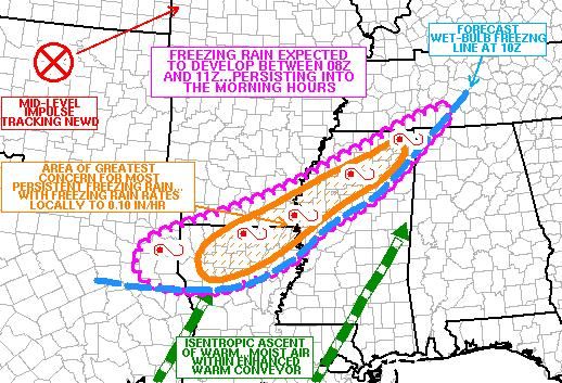
Table 3.9.2 summarizes the number of incidents recorded by NCDC for winter weather events in
Mississippi by MEMA Regions.

                                       Table 3.9.2
                        Summary of Events by MEMA Region/County
                                       1996-2017

   County      No. of    Total           Total         County        No. of    Total            Total
               Events   Property         Crop                        Events  Property           Crop
                        Damage          Damage                               Damage            Damage
                 MEMA Region 1                                       MEMA Region 2
Coahoma           20      $37,000              $0   Alcorn             27      $27,100             $0
DeSoto            33      $33,000              $0   Benton             32      $25,100             $0
Grenada           14   $3,176,000              $0   Itawamba           19      $23,000             $0
Panola            18      $27,000              $0   Lafayette          22      $22,000             $0
Quitman           17      $31,000              $0   Lee                19      $43,000             $0
Tallahatchie      15      $30,000              $0   Marshall           32      $24,100             $0
Tate              26      $24,100              $0   Pontotoc           22      $27,000             $0
Tunica            30      $34,000              $0   Prentiss           21      $32,000             $0
Yalobusha         19      $30,000              $0   Tippah             30      $24,100             $0
                                                    Tishomingo         21      $32,100             $0
                                                    Union              23      $27,100             $0

  County       No. of    Total          Total          County       No. of     Total            Total
               Events  Property         Crop                        Events   Property           Crop
                       Damage          Damage                                Damage            Damage
                MEMA Region 3                                        MEMA Region 4
Atalla           15   $1,343,000              $0    Calhoun           16       $26,000              $0
Bolivar          25   $2,087,000              $0    Chickasaw         17       $26,000              $0
Carroll          13   $1,595,000              $0    Choctaw           14    $1,461,000              $0
Holmes           13   $1,195,000              $0    Clay              13      $990,000              $0
Humphreys        14   $1,110,000              $0    Lowndes           14    $1,168,000              $0
Leflore          15   $4,010,000              $0    Monroe            17       $26,000              $0
Montgomery       12   $1,318,000              $0    Noxubee           15      $943,000              $0
Sunflower        20   $2,415,000              $0    Oktibbeha         17    $2,310,000              $0
Washington       21   $2,317,000              $0    Webster           15    $1,523,000              $0
                                                    Winston           15    $1,741,000              $0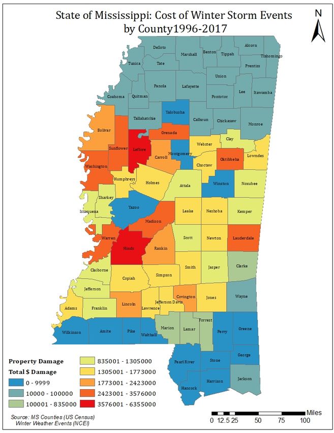
County       No. of    Total           Total         County         No. of    Total          Total
               Events  Property          Crop                         Events  Property         Crop
                       Damage           Damage                                Damage          Damage
                MEMA Region 5                                         MEMA Region 6
Claiborne        10   $1,065,000               $0   Clarke              7      $635,000               $0
Copiah           12   $1,380,000               $0   Jasper              9    $1,155,000               $0
Hinds            14   $3,335,000               $0   Kemper             12      $920,000               $0
Madison          13   $2,389,000               $0   Lauderdale         14    $2,260,000               $0
Rankin           13   $2,726,000               $0   Leake              12    $1,495,000               $0
Simpson          10   $1,370,000               $0   Neshoba            10    $1,450,000               $0
Warren           13   $2,495,000               $0   Newton             13    $1,515,000               $0
Yazoo            14   $1,975,000               $0   Scott              12    $1,220,000               $0
                                                    Smith              10    $1,325,000

  County      No. of     Total          Total           County        No. of    Total           Total
              Events   Property         Crop                          Events  Property          Crop
                       Damage          Damage                                 Damage           Damage
                MEMA Region 7                                         MEMA Region 8
Adams            10   $1,265,000              $0    Covington           9    $1,690,000         $40,000
Amite            13            $0             $0    Forrest             6      $305,000              $0
Franklin         8             $0       $800,000    Greene              7             $0             $0
Jefferson        9      $815,000         $20,000    Jefferson Davis     9    $1,141,000              $0
Lawrence         8    $1,180,000              $0    Jones               10   $1,355,000         $40,000
Lincoln          9    $1,785,000         $20,000    Lamar               4      $205,000              $0
Pike             8              $             $0    Marion              6      $305,000              $0
Walthall         7              $             $0    Perry               5             $0             $0
Wilkinson        9              $             $0    Wayne               10      $10,000              $0

  County      No. of        Total       Total       County            No. of       Total        Total
              Events      Property      Crop                          Events     Property       Crop
                          Damage       Damage                                    Damage        Damage
                                          MEMA Region 9
George           4                $0          $0 Jackson                4                $0           $0
Hancock          4                $0          $0 Pearl River            4                $0           $0
Harrison         4                $0          $0 Stone                  3                $0           $0

The following maps (Figures 3.9.1 and 3.9.2), “Winter Storm Events by County 1996 – 2017” indicates
which counties were impacted by winter storms documented in Table 3.9.2. As illustrated on the map,
event occurrence follows a geographic pattern. Winter storms occur most frequently in the northern
counties with frequency of occurrence diminishing in a southward pattern.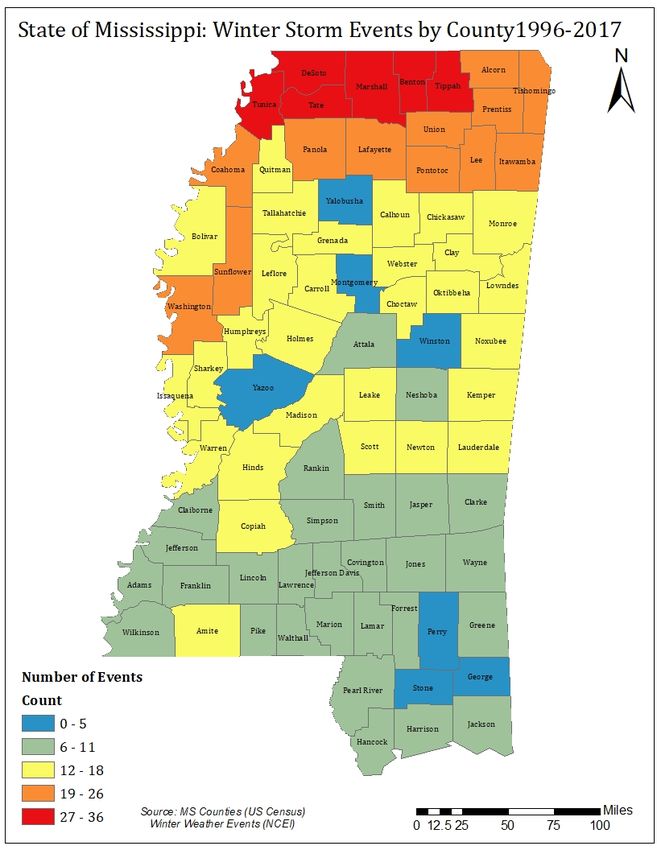
Snowfall in Mississippi occurs in the northern and central areas, but rarely in the southern areas.
Snow in the northern counties is most frequent from December to March, with accumulations
lasting only one or two days.

                                        Figure 3.9.1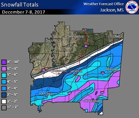
Figure 3.9.2
Cold weather, including extreme cold and wind chill, impact Mississippi causing property damage
and deaths. These events also impact aging infrastructure, as in 2010, which is described in the
historical events section. Table 3.9.3 and Figure 3.9.3 provide details of these events and the
counties impacted.
Table 3.9.3
Cold-Related Events
No. of Property
Event Type Date Events Counties Affected Deaths Damage
Winter Weather December 31, 2017 11 Chickasaw, Choctaw, Clay, 0 $0
Jasper, Lowndes, Monroe,
Montgomery, Newton,
Oktibbeha, Rankin, Webster
Heavy December 7, 2017 48 Adams, Amite, Attala, Choctaw, 1 $820,000
Snow/Winter Claiborne, Clarke, Clay, Copiah,
Storm Covington, Forrest, Franklin,
Greene, George, Hancock,
Harrison, Hinds, Jackson,
Jasper, Jefferson, Jefferson
Davis, Jones, Kemper, Lamar,
Lauderdale, Lawrence, Leake,
Lincoln, Lowndes, Madison,
Marion, Neshoba, Newton,
Noxubee, Oktibbeha, Pearl
River, Perry, Pike, Rankin,
Scott, Simpson, Smith, Stone,
Walthall, Warren, Wayne,
Wilkinson, Winston, Yazoo
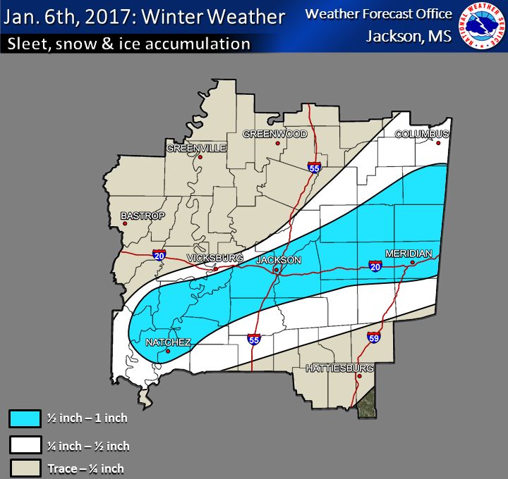
Winter January 6, 2017 36 Adams, Alcorn, Amite, Benton, 0 $2,125,000
Storm/Sleet/ Claiborne, Clarke, Copiah,
Winter Covington, DeSoto, Franklin,
Weather/Ice Storm Hinds, Jasper, Jefferson,
Jefferson Davis, Jones,
Kemper, Lauderdale, Lawrence,
Leake, Lincoln, Madison,
Marshall, Neshoba, Newton,
Noxubee, Rankin, Scott,
Simpson, Smith, Tate, Tippah,
Tunica, Warren, Wayne,
Winston
Winter January 22, 2016 13 Benton, Coahoma, DeSoto, 0 $0
Storm/Winter Lafayette, Marshall, Panola,
Weather Pontotoc, Quitman,
Tallahatchie, Tate, Tippah,
Tunica, Union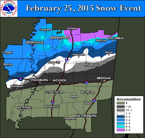
Winter           March 4-5, 2015     46   Attala, Alcorn, Benton, Bolivar,   0       $0
Storm/Sleet                               Calhoun, Carroll,
                                          Chickasaw, Claiborne, Clay,
                                          Choctaw, Coahoma,
                                          DeSoto, Grenada, Hinds,
                                          Holmes, Humphreys,
                                          Issaquena, Itawamba,
                                          Lafayette, Lee, Leflore,
                                          Lowndes, Madison, Marshall,
                                          Montgomery, Monroe,
                                          Oktibbeha, Panola, Pontotoc,
                                          Prentiss, Quitman, Sharkey,
                                          Sunflower,
                                          Tallahatchie, Tate, Tippah,
                                          Tishomingo, Tunica, Union,
                                          Warren, Washington, Wayne,
                                          Webster, Winston, Yalobusha,
                                          Yazoo
Winter           February 25, 2015   42   Alcorn, Attala, Benton, Bolivar,   0       $0
Storm/Heavy                               Calhoun, Carroll, Chickasaw,
Snow                                      Choctaw, Clay, Coahoma,
                                          DeSoto, Grenada, Holmes,
                                          Humphreys, Issaquena,
                                          Itawamba, Lafayette, Lee,
                                          Leflore, Lowndes, Marshall,
                                          Montgomery,
                                          Monroe, Noxubee, Oktibbeha,
                                          Panola, Pontotoc, Prentiss,
                                          Quitman, Sharkey, Sunflower,
                                          Tallahatchie, Tate, Tippah,
                                          Tishomingo, Tunica, Winston,
                                          Washington, Webster, Union,
                                          Yalobusha, Yazoo
Winter Weather   February 23, 2015   5    Bolivar, Hinds, Madison,           0   $39,000
                                          Warren, Washington
Winter Weather   February 20, 2015   25   Alcorn, Benton, Bolivar,           0   $19,000
                                          Calhoun, Chickasaw,
                                          Coahoma, DeSoto, Hinds,
                                          Itawamba, Lafayette,
                                          Lee, Marshall, Monroe, Panola,
                                          Prentiss, Pontotoc, Quitman,
                                          Rankin, Tallahatchie, Tate,
                                          Tippah, Tishomingo, Tunica,
                                          Union, Yalobusha
Winter Storm     February 16, 2015   8    Alcorn, Benton, DeSoto,            0       $0
                                          Marshall, Tate, Tippah,
                                          Tishomingo, Tunica
Winter Weather   January 9, 2015     1    Pike                               0       $0

Winter Weather   November 13, 2014   1    Marshall                           0       $0
Winter March 3-4, 2014 4 Amite, DeSoto, Tunica, 0 $0
Storm/Winter Wilkinson
Weather
Winter February 11, 2014 22 Adams, Alcorn, Calhoun, 0 $50,000
Weather/Ice Storm Chickasaw, Claiborne,
Humphreys, Issaquena,
Itawamba, Jefferson, Lafayette,
Lee, Monroe, Prentiss,
Pontotoc, Sharkey, Tippah,
Tishomingo, Union, Warren,
Washington, Yalobusha, Yazoo
Winter Weather February 2-4, 2014 1 Tunica 0 $0
Winter January 28, 2014 27 Adams, Amite, Claiborne, 0 $0
Storm/Sleet/Heavy Clarke, Copiah, Covington,
Snow/Winter Franklin, Greene, Hancock,
Weather Harrison, Hinds, Jackson,
Jasper, Jefferson, Jefferson
Davis, Jones, Lauderdale,
Lawrence, Newton, Pearl River,
Pike, Rankin, Scott, Simpson,
Smith, Walthall, Wayne
Winter Weather Jan 23-24, 2014 8 Amite, Hancock, Harrison, 0 $0
Jackson, Pearl River, Walthall,
Wilkinson
Winter Weather December 6-7, 2013 8 DeSoto, Coahoma, Marshall, 0 $0
Panola, Quitman, Tate, Tippah,
Tunica
Ice Storm January 13-17, 2013 50 Alcorn, Attala, Bolivar, Benton, 0 $540,000
Carroll, Chickasaw, Choctaw,
Claiborne, Clay, Copiah,
Grenada, Hinds, Holmes,
Humphreys, Issaquena,
Itawamba, Jefferson Davis,
Kemper, Lafayette, Lauderdale,
Leake, Leflore, Lowndes,
Madison, Marshall, Monroe,
Montgomery, Neshoba,
Newton, Noxubee, Oktibbeha,
Prentiss, Pontotoc, Quitman,
Rankin, Scott, Sharkey,
Simpson, Smith, Sunflower,
Tallahatchie, Tippah,
Tishomingo, Union, Warren,
Washington, Webster, Winston,
Yalobusha, Yazoo
Cold/Wind Chill Jan 1-14, 2010 47 Adams, Attala, Bolivar, Carroll, 3 $15,180,000
Choctaw, Claiborne, Clarke,
Clay, Covington, Copiah,
Forrest, Franklin, Grenada,
Hinds, Holmes, Humphreys,Issaquena, Jasper, Jefferson,
Jefferson Davis, Jones,
Kemper, Lamar, Lauderdale,
Lawrence, Leake, Leflore,
Lincoln, Lowndes, Madison,
Marion, Montgomery, Neshoba,
Newton, Noxubee, Oktibbeha,
Rankin, Scott, Sharkey,
Simpson, Smith, Sunflower,
Warren, Washington, Webster,
Winston and Yazoo
Cold/Wind Chill Dec 25, 2004 Itawamba 1 $0
Cold/Wind Chill Jan 24, 2003 1 Monroe 1 $0
Extreme Cold/ Dec 31, 2000 1 Lafayette 1 $0
Wind Chill
Cold/Wind Chill Dec 18, 1996 8 Amite, Hancock, Harrison, 0 $0
Jackson, Pearl River, Pike,
Walthall and Wilkinson
Cold/Wind Chill Feb 1-2, 1996 10 Amite, Desoto, Hancock, 3 $100,000
Harrison, Jackson, Pearl River,
Pike, Walthall, Wilkinson and
Yalobusha,
Total 10 $18,873,000
As previously stated, Mississippi is susceptible to winter-weather related events causing deaths and
significant property and crop damages. Table 3.9.4 identifies two presidentially declared events in 1994
and 1998, followed by brief descriptions of each. The 2010 and 2017 cold weather events, described in the
historical events section, caused damage to water lines serving residents, city and state agencies and
crippled the city of Jackson. There have been no declarations since December 1998.
Table 3.9.4
Presidential Disaster Declarations – Winter Weather
Declaration No. of Counties Date of Major
Number Incident Period Affected Declaration
DR-1265 December 23 – 26, 1998 33 January 25, 1999
DR-1009 February 9 – 14, 1994 26 February 18, 1994Historical Events
December 8, 2017 Snow
Just three days prior to the winter storm, temperatures were in
the upper 60s and lower 70s across much of the area ahead
of a series of arctic cold fronts. The first arctic front moved
through the area during the day on December 5th and ushered
in a cooler and drier airmass in its wake as temperatures
dropped into the 40s with dewpoints in the upper 20s. A
second reinforcing arctic cold front moved through the
ArkLaMiss during the day on December 7th and brought
another shot of drier and colder air. A modified continental
polar airmass became locked in across the region with a
parent 1035 mb high centered over the Southern Plains. As
the stronger upper level flow and support pulled away from the
southeastern United States, the two arctic cold fronts slowed
down and eventually stalled over the northern Gulf of Mexico,
helping to establish a strong quasi-stationary front. Further aloft, the synoptic pattern leading up to the
winter storm was characterized by an upper level longwave trough centered over the Northern Plains
and Great Lakes with multiple shortwave troughs rotating through the Inter-Mountain West and Four
Corners region. On the morning of December 7th, a stout shortwave trough was located over the Four
Corners and was forecast to eject into the Southern Plains, thus setting the stage for a significant winter
storm across the Deep South.
Strong upper-level divergence and ascent
ahead of the advancing shortwave trough
overspread the northern Gulf of Mexico in the
vicinity of the stalled baroclinic zone and
helped to induce surface cyclogenesis. The
nose of a strengthening jet streak moved into
southern Texas as the shortwave progressed
into central Texas on the evening of
December 7th. The resulting force for ascent
allowed heavy snowfall to begin accumulating
in many locations across the Deep South of
Texas throughout the evening. This snowfall
spread across south and east Texas and into
Louisiana and
Mississippi through the early morning
Source: JWS Photo: Zander Williamson
hours on December 8th. Strong isentropic ascent on top of the sloped boundary, working in concert with
exceptional upper-level divergence in the right entrance region of an impressive 180 kt jet, allowed heavy
snowfall to spread across a large portion of central and southern Mississippi. While surface temperatures
were above freezing, evaporational and dynamical cooling due to a dry sub-cloud layer allowed surfacetemperatures to drop into the low 30s, and heavy snow began accumulating quickly as higher snowfall rates overspread the area through the morning hours. While the heaviest snow accumulations were limited to grassy and elevated surfaces, decent slushy accumulations were able to build on roadways, especially during the highest snowfall rates. Snowfall gradually tapered off from west to east through the day with snow ending in the Jackson metro by mid-morning and eventually ending in the south and east portion of the forecast area by mid-afternoon. The highest storm total snowfall amounts were focused along and southeast of a line from Brookhaven to Meridian where higher snowfall rates were realized in an area of banded snowfall that occurred in the presence of conditional symmetric instability. The highest snowfall total was 8”, which was reported in two different locations (see totals below) and was part of a heavy swath of widespread 6-7.5” from Brookhaven to Meridian where the aforementioned snow banding occurred. Elsewhere, totals dropped off gradually to the north with 4-6” in the Jackson metro. The official snowfall measurement at the NWS Jackson office was 5.1”, which was high enough to rank as the 7th snowiest day all-time and the largest snowfall since 1982. In Meridian, the total was 5” and was the 3rd highest daily snowfall on record and the largest daily snowfall since 1993. For Hattiesburg, the event total snowfall was 4.1” January 6, 2017 Winter Weather A complex weather pattern eventually evolved into a widespread winter weather event across the area on January 6th, 2017. Strong surface high, near 1030mb, was building into the central and southern Plains. Tuesday, January 2nd, 2017 was much warmer being in the 70s with severe weather and tornadoes, while in the wake over the two days after on Wednesday and Thursday, strong surface high pressure with much cooler air gradually filtered in. The strongest push of strong high pressure and colder air began to move in Friday morning. A sharp contrast in temperatures existed across the area from the lower Mississippi Valley into the Gulf of Mexico as a stalled frontal boundary stayed situated along the coast. This helped the cold air stay locked in place over the area, with temperatures near freezing Friday morning. In addition, a strong upper level disturbance was helping to promote lift and an area of snowfall moving through Oklahoma/Arkansas region by early Friday morning. This area mostly stayed just to the north of the region. Along and over top of the shallow arctic airmass, as the upper disturbance approached, moisture began to overrun the cold air below by early Friday morning. This moisture gradually overran the entire region by mid-morning. The atmosphere contained a deep melting layer, that as a snowfall fell, it completely melted. However, there was enough of a layer below
that near the ground that helped to refreeze most of the precipitation to fall in the form of sleet and
freezing rain. By early Friday morning, sleet began to fall over northeast Louisiana and spreading to the
north and east into most of the ArkLaMiss by mid-morning to late afternoon. There were some cases of
some shallow instability present for some thunder to occur with the sleet.
The main disturbance and lift occurred in the mid-to-late afternoon and the heaviest sleet production
occurred during that time, right around rush hour. To make matters worse, temperatures were hovering in
the low 30s to upper 20s while precipitation was falling. Overall, with such cold temperatures throughout
the afternoon, there was significant sleet accumulation, especially from Franklin Parish in Louisiana,
southeast towards Adams County in Louisiana, over to Warren County in Mississippi, throughout the
Jackson Metro area and east along I-20 towards Lauderdale County and as far north as Noxubee County.
Heavy sleet occurred throughout this region, with some areas approaching a 1/2 to 1 inch of sleet. Some
areas in east-northeast Mississippi had enough precipitation with temperatures cooling in the atmosphere
to briefly change over to snow as well near Meridian and east-northeast Mississippi. Most areas in
southeast Mississippi were slower to change over to mixed precipitation until later in the event. With cold
ground and road temperatures, significant icing and accumulation began across the roadways throughout
portions of northeast Louisiana, central, east and northeast Mississippi, especially along the Interstate 20
corridor. This led to significant icing on roadways and bridges, leading to icy roadways and major traffic
issues. Many accidents occurred across the region, leading to some major thoroughfares being shut
down, at least temporarily, especially for portions of Interstate 55, Interstate 20 and other roadways. This
led to many area residents encountering slow-downs in traffic and some being stuck for many hours on
the roadways. In addition, the Jackson International Airport had to be shut down due to icy runways. The
disturbance gradually moved east, helping the precipitation to taper off and move out by late evening,
around 9-10PM.
The strong surface high built and strengthened near 1040mb, leading to much colder air filtering in
overnight and through the weekend. This led to hard freeze conditions with highs struggling to reach the
freezing mark, especially across central and northern areas. A snowpack existed over central Arkansas,
northern Mississippi and southern Tennessee. With northerly winds over that snowpack, this helped to lock
in even colder air and biting wind chills, with wind chills falling into the single digits over most of the area.
Some areas in the Delta stayed below freezing for over 60 hours. This in addition to temperatures falling
into the low-mid teens over the next several nights, kept a lot of winter weather accumulation lingering
around through the weekend, with icy roadways for the next couple of days into Saturday, January 7th and
Sunday, January 8th. This led to significant traffic issues lingering into the early weekend, with roadways
gradually improving as some of that melted under full sun by Saturday and mostly gone by Sunday into the
start of the following work week. This significant winter weather event will be one that will be remembered
for years to come.

February 25, 2015 Snow Event

Multiple rounds of wintry weather had occurred prior to this snowfall event. A cold front had moved
through the region four days earlier on February 21st with a cold airmass in its wake. Several waves of
upper level disturbances moved through Mid-South, over the course of the next three days. The first, on
the night of the 22nd, brought mostly rain to the region but some light icing occurred in the far northern
Delta early on the 23rd. A second, more potent disturbance, moved through Central Mississippi during the
afternoon and evening hours on the 23rd. This brought a better icing event to locations generally along
and north of I-20, causing some power outages and accidents.
With the cold remaining in place, the final round of
wintry weather moved in on the morning of February
25th. A strong upper level disturbance moved across
the region, which induced a low-pressure system to
move east across the northern Gulf of Mexico. With the
cold air already entrenched over the region, this brought
the needed moisture and atmospheric lift needed to
generate precipitation. At first, the precipitation started
as rain and freezing rain, with some light icing reported
across the ArkLaMiss. As the atmosphere cooled
through the late morning, the rain began to change to
snow in the early afternoon across southeast Arkansas,
northeast Louisiana and the Mississippi Delta. The
changeover line from rain to snow slowly progressed
from northwest to southeast across northern portions of
the ArkLaMiss region. By the time the changeover
occurred near the I-20 corridor, the precipitation was
moving off to the east into Alabama.
Those who got snow north of I-20 saw several heavier bursts, which led to some high snowfall totals. The
highest totals were generally along and north of the Highway 82 corridor. Locations from Grenada to
northern Lowndes county saw the highest amounts in our county warning area, with totals ranging from
six to eight inches. Those who saw the higher totals also dealt with trees being weighed down by the
heavy snow. This led to snapping trees and numerous power outages.

January 28, 2014 Winter Storm

Temperatures on January 27th were in the upper 40s in the northwest Delta to the mid-50s to low 60s in
southeastern Mississippi. However, a large upper trough was diving southeast, bringing an arctic front
and 1032mb surface high pressure into the ArkLaMiss. Temperatures dropped rapidly in the evening as
very dry air filtered into the region, with dewpoints falling into the single digits. The large spread between
the surface and dewpoint temperature would be an important player in the winter weather event on
January 28th. As the upper trough deepened and strong upper level winds began to move over the
region, an upper level low center over northern Mexico to the southwestern United States began to merge
with the strong upper level system and moistened the mid-levels of the atmosphere across the region.
Temperatures were only in the low to mid 20s throughout the ArkLaMiss as the precipitation began to fall.
Areas along and north of a line from around Natchez to just south of Meridian began to observe
precipitation that initially fell as sleet but gradually transitioned to snow in just a few hours as
temperatures cooled in the mid-levels of the atmosphere and the lower atmosphere saturated from falling
precipitation and evaporative cooling. Due to a warm layer in the mid-levels of the atmosphere, mixed
precipitation occurred from south of a line near Natchez to south of Meridian. The deep melting layer
caused precipitation to remain as sleet throughout most of the afternoon south of that line. These areas
had a prolonged period of sleet before finally transitioning over to snow in the mid to late afternoon hours.
All precipitation moved out of the region by around 6-8pm on the evening of January 28th.

In total, areas north of the mixed precipitation line had more significant snowfall. This was a heavy
confined band of precipitation that dropped off quickly closer to the Jackson metro with areas in
southeastern Rankin County having the highest snowfall totals. This area had 2-4 inches of snowfall, with
maximum of 4 inches in the Puckett area. Snow tapered off quickly near the Interstate 20 corridor with
only near ½ inch to 1-inch snowfall, with some locally higher amounts. Snow accumulation extended into
north central Mississippi up to the Highway 82 corridor near Indianola eastward towards Macon but only a
light dusting occurred in these regions. South of the mixed precipitation line, significant icing and sleet
occurred in the region with upwards of 1-3 inches of sleet and snow. The significant icing occurred into far
southern Marion, Lamar and Forrest counties.

Significant icing occurred on the roadways and led to multiple accidents and issues with travel. There was
an extended hard freeze, with temperatures dropping into the low teens and single digits regionwide on
the morning of January 29th. This kept lingering snow and sleet accumulations frozen and made travel
hazardous, especially along and south of the Interstate 20 corridor. Temperatures only climbed into the
low to mid 30s on January 29th before falling back into the teens overnight of January 30th. The region
finally warmed above freezing on the mid to late morning hours of January 30th.

January 14-17, 2013 Snow and Ice

A near record-long duration of wet weather brought widespread flooding and two winter storms to the
ArkLaMiss during the period from January 6th through January 17th. There were three key ingredients
that allowed this very active weather pattern to take shape.
    •   An unseasonably strong and very warm high-pressure center set up over the South Atlantic
        states. The clock-wise flow around this high-pressure center was able to tap tropical moisture
        and transport it northward through the Lower Mississippi Valley.
    •   An upper level trough took up residence over the western states and this created upper level
        southwest flow. Such upper level patterns are favorable for heavy rain in our region because
        they focus very moist air along stalled fronts.
    •   The northern stream sent a series of cold fronts southward to the Gulf Coast. Not only did the
        cold air behind the front support ice and snow, but the frontal lift was necessary for multiple
        rounds of heavy rainfall that led to flooding.

Ice Storm – January 14-16, 2013

A strong cold front brought a shallow and very chilly air mass southward into the ArkLaMiss the night of
January 13th. The cold air undercut relatively mild air aloft, thus setting the stage for freezing rain over
northwest portions of the ArkLaMiss. A couple of episodes of moderate freezing rain accompanied by
thunder occurred in this time frame with temperatures hovering near or just below 32 deg F.
These weather maps from the Storm Prediction Center, analyzed during the ice storm, depict the general set-up and potential area for heavier ice accumulation. Just as the ice storm was ending in the “Delta” region, an upper level low was moving steadily east toward the region and this ultimately brought the heavy snow that fell over much of the ArkLaMiss. Heavy Snow – January 17, 2013 The very cold air aloft associated with the upper low made the atmosphere more favorable for snow as we went into the early morning hours of Thursday, January 17th. A strong lift caused widespread light to moderate rain to develop during the evening of January 16th as surface temperatures held just above freezing. Late that night rain transitioned briefly to sleet before switching to all snow from west to east. In far eastern portions of Mississippi, rain did not switch to snow until after daybreak. There were two main bouts of freezing rain causing icing over portions of northeast Louisiana, southeast Arkansas, and northwestern portions of central Mississippi - one during the daytime hours of January 14th and another during the daytime and evening hours of January 15th. In many areas, temperatures remained below freezing during this entire time period, and thus, there was no melting between the two icing events.
The above ice accumulation map represents the greatest reported storm total ice accumulation at any
given location, which for some locations includes cumulative amounts over the 2-to-3-day period. The
greatest accumulation amounts of around or just above 1/2" of ice were in a corridor from near Bastrop, LA
to Cleveland, MS. Most icing occurred on elevated surfaces, such as trees and other vegetation, cars, utility
lines, and bridges. However, there was also some icing on roadways, causing several traffic accidents.

Snowfall totals were generally around 2-3" from the I-55 corridor between Grenada and Jackson eastward
to the Alabama state line. Because of the nature of this system, there were multiple heavier north-to-south
oriented snow bands, creating great variations in snow accumulations over short distances. For instance,
there were snow accumulation amounts as great as 3.5" along the Pearl River in the Jackson area, while
accumulations of as little as 1" were reported just to the west in Raymond and as little as 1.5" just to the
east in Goshen Springs. The greatest reported snowfall accumulation in the NWS Jackson forecast area
occurred under a heavier snow band over portions of Webster, Choctaw, western Clay, and western
Oktibbeha counties;6 inches of snow was reported just to the east of Ackerman. Conditions along Highway
82 were very treacherous in this area.

Prolonged Sub-Freezing Temperatures – January 1-14, 2010

The Central Mississippi water supply failure of January 2010 is an example of how large metropolitan and
less populated areas can be affected by extreme cold weather events. Prior to January 11, 2010, Central
Mississippi experienced 11 straight days of sub-freezing overnight temperatures and six days of overnight
temperatures of 20 degrees or less. From the evening of January 7 to the morning of January 10,
temperatures remained below 32 degrees. By January 10, the Jackson, Mississippi water supply system
began losing pressure, and when the daily high temperature reached 48 degrees on January 11, it became
apparent Jackson and several other Central Mississippi towns and cities would experience major water-
pressure problems due to water main breaks.

On January 11, Governor Haley Barbour issued an emergency declaration that was eventually expanded
to include all affected areas. The state’s Emergency Operations Center was partially activated January 13
to help cities and counties with the ongoing crisis. Staff specializing in public works, engineering, logistics
management and public health went on 12-hour shifts. Mississippi Emergency Management Agency
delivered bottled water to the affected areas.

The City of Jackson water system sustained 80 major breaks and spewed 22 million gallons of water
throughout the city. That number eventually reached 150 broken water mains with an unknown quantity of
wasted water. According to news reports, the City of Jackson reported up to 200,000 residents were
without water. Adding to the problems, an electrical fire took a city water treatment plant off line and
further diminished the city’s capacity to pump water. Many Jackson residents were entirely without water
for more than 24 hours. The cities of Madison, Ridgeland, Hattiesburg and Greenville offered water crews
to help patch the leaks, and the city of Pearl furnished water for two of Jackson’s largest hospitals.

On January 7, portions of Jackson and the City of Byram, south of Jackson, were placed on a boil water
notice that remained in effect until January 24. On January 11, the entire Jackson water system, including
most of the metropolitan area, was placed under a boil water notice that lasted seven days. These
requirements, combined with a lack of water pressure, caused a multitude of problems including
business, restaurant and school closures, relocation of two police precincts and adjournment of the
Mississippi Legislature, which was in session at the Capitol in Jackson. For locations that remained in
operation, flushing toilets and other hygienic measures became a problem. The Jackson Convention
Complex was forced to provide extraordinary water and restroom facilities for a 400-person Affordable
Housing Conference. Fire departments delivered water to jails and other critical facilities. Portable toilets
were in such demand that vendors had to go out of state to supply the crisis.

AT&T, which operates switching centers for its cell and land lines and other providers that utilize the
company’s infrastructure, including emergency communications systems, was forced to park water-filled
tanker trucks outside its facilities to cool equipment and provide fire protection. A National Guard tanker
provided 5,000 gallons of water to cool computers for several state agencies providing essential services.

Mississippi State Department of Health (MSDH) went into emergency mode. Tasked with providing
engineers for Emergency Support Function (ESF) #3 of the State’s Comprehensive Emergency
Management Plan (CEMP), MSDH also began emergency procedures to protect the health and safety of
the public. That task included providing extra staff to sample and test potable water supplies from
affected communities and inspect food service providers such as restaurants, shelters, clinics and
schools to ensure safe operation. The department temporarily closed some restaurants until they could
adjust to emergency operation requirements.

State Agencies Impacted

On Sunday, January 17 the boil-water alert was cancelled for most of the city, ending a week of crises
unequaled in recent Jackson history. This event left behind a legacy of business losses, school days to
be made up, huge potholes to be repaired where water crews accessed system breaks, and a large
budgetary problem for the City of Jackson. Mitigation of future problems for Jackson’s aging water main
system was projected to cost over $75 million. With tax revenues in decline, the City’s water supply
problem was not a small one.

Affected Cities and Counties

The following numbers of residents of Central Mississippi cities and counties were affected by the
January 2010 water supply:
        Emergency: Jackson (200,000); Lauderdale County (14,000); Port Gibson (10,500); Marks
        (2,300); Walnut (500); Vicksburg (250); Wayne County (150); Tunica County (number not
        available); Carroll County (number not available).

DR-1265 – December 23-26, 1998

A crippling ice storm struck Arkansas, Louisiana, and Mississippi on the evening of December 22, 1998,
bringing freezing rain and sleet to the three-state region. Much of the fall and early winter season of late
1998 was very mild, but a strong surge of shallow arctic air drove southward and spelled an end to the
unseasonable warmth. A moist southwest flow above the cold air brought several upper level disturbances.
The combination of cold air and moisture caused periods of freezing rain and sleet until Christmas morning.
Almost two inches of ice accumulated on power lines, causing outages for up to seven days. Tree and
power line damage was moderate to severe from northeast Louisiana to northcentral Mississippi. Due to
more foliage than usual on trees, the extra weight of ice accumulation caused large oaks and maples to
split in half. Travel was severely hampered for several days with motorists stranded at airports, bus
stations, and truck stops.
Counties in Mississippi affected by the storm included Leake, Lee, Leflore, Lowndes, Monroe, Montgomery,
Neshoba, Noxubee, Oktibbeha, Pontotoc, Prentiss, Sharkey, Sunflower, Tallahatchie, Tishomingo, Union,
Warren, Washington, Webster, Winston, Yalobusha, and Yazoo.
Public Assistance Dollars Obligated
Impact Summary
Declared Counties
• No of Counties Affected: 33 Total PA Grants Emergency Work Permanent Work
• Deaths: 0 (Categories A-B) (Categories C-G)
• Injuries: 0
• Estimated Property Damage:
$6,970,269 $2,590,192 $4,349,918
$16,699,000
DR-1009 – February 9-14, 1994
In 1994, a damaging ice storm with freezing rain
accumulations of three to six inches occurred
across north Mississippi, southeast Arkansas,
west Tennessee, northwest Alabama, north
Louisiana, and extreme northeast Texas
between February 9th and 11th. In Mississippi,
the ice storm was the worst since 1951, with
total damage estimates exceeding $300 million
and a federal disaster declaration for 26
counties.
According to Mississippi Power and Light Company estimates, 500,000 persons in roughly 200,000 homes
had no electricity at the height of the storm and 175,000 homes had no water. Twenty percent of
Mississippians lost power for at least one day. Approximately 300 water systems were also severely
affected for a week or more with over 300,000 customers advised to boil water before use.The United States Department of Agriculture studied forest damage in the storm-affected area. There were
2.1 million acres of forest land in northeast Mississippi within the 3.7-million-acre study area. Less than 1
percent of the forest land was untouched by some degree of damage. Net loss to live-tree volume, due to
probable mortality, amounted to 16.5 percent of hardwoods and 15.3 percent of softwoods. The majority of
volume loss occurred in areas that received about 25 percent mortality to the forest resource.
Mississippi counties included in the federal disaster declaration included: Alcorn, Benton, Bolivar, Calhoun,
Chickasaw, Coahoma, Desoto, Grenada, Itawamba, Lafayette, Lee, Leflore, Marshall, Panola, Pontotoc,
Prentiss, Quitman, Sunflower, Tallahatchie, Tate, Tippah, Tishomingo, Tunica, Union, Washington and
Yalobusha.
Public Assistance Dollars Obligated
Impact Summary
Declared Counties
• No of Counties Affected: 26 Total PA Grants Emergency Work Permanent Work
• Deaths: 0 (Categories A-B) (Categories C-G)
• Injuries:0
• Estimated Property Damage:
$500,000
Unknown
• Estimated Crop Damage:
$5,000,000,000
Source: NCDC Source: FEMA
It is important to note that there have been no declarable events since 1994.
Winter Storm Events Prior to 1993
The National Weather Service, via NCDC, has created a consistent database of winter events since 1993;
however, there were many severe storms prior to this time period. The chart below plus two specific events
present some of the significant historical winter storms in Mississippi.
Significant Historical Snow Storms
1940 – 2017
Year Area Inches
January 2017 Central and North Mississippi 2.5
January 2016 Central and North Mississippi 8
January 2015 Central and North Mississippi 1
January 2014 North and Central Mississippi 2
January 2013 North Mississippi 8
January 2012 Central Mississippi 4January 2011 Adams County 3
January 2010 North Mississippi 6
January 2009 North Mississippi 7
January 2008 North Mississippi 10
January 2007 Central and South Mississippi 8
January 2006 North Mississippi 3
January 2005 Central and South Mississippi 9
January 2004 Chico and Bolivar County 6
Covington, Jefferson Davis, and
January 2003
western Jones Counties, 5
January 2002 South Mississippi 4.5
March 1993 Mississippi 6
1974 Gulf Coast 5
1967 – 1968 Tate County 25.2
1966 Bolivar County 23
1960 Hinds County 9.1
1940 Hinds County 10.6
January 28 – February 5, 1951: Approximately $50 million in damages was incurred in Mississippi. Twenty-
two people died in the storm throughout Mississippi, Louisiana and Arkansas.
January 11 – 15, 1982: An ice storm centered in the northern and eastern parts of the state, caused heavy
damages in 44 counties and affected 25% of the states’ nurseries. One death was reported.
Probability of Future Winter Storm Events
The area most likely to receive an ice storm, heavy snow, or winter storm activity is the area north of
Interstate 20, the northern half of Mississippi. Historically based on data from the NCDC, winter events
occur as early as mid-December and as late as mid-March. In the past 20 years, Mississippi recorded some
magnitude of winter weather except for the years of 1995, 1999, 2001, 2005 and 2012. Therefore, a 25
percent probability of a winter weather event striking the state should be expected.
Assessing Vulnerability
An assessment of Mississippi’s vulnerability to winter storms reveals advance warnings are often not
regarded or taken seriously enough. Preparedness for a winter storm is just as important as preparing for
other hazards. As is the case with other natural hazards, the very young, the elderly, persons with special
needs and handicapped people are vulnerable to winter storms. Officials also suggest institutions housing
these individuals develop a plan to include preparedness for lack of electricity, water, and fuel for heating
Public buildings are not as vulnerable to winter storms as infrastructure such as electric transmission lines
and utility poles that can all be weighed down by ice and freezing rain. During the 1994 ice storm 8,000
utility poles were downed by the weight of ice, 4,700 miles of power lines were downed, and 491 water
systems were affected, with 741,000 customers without waterVulnerability of People to Winter Storms
The public warning systems alerting the general public of an impending storm are the existing media
outlets, the National Weather Service and NOAA weather radios. Now, there is Twitter, Facebook, Instagram
and other social media outlets.
The oxygen and insulin-dependent, the elderly, those whose medical conditions require regular visits by
home health care workers, and children living in these households make up the special needs group whose
lives are most in danger when a power failure occurs. These citizens must rely on neighbors and relatives
for contact, supplies and assistance throughout the disruption. Previous incidents have left remote areas of
the state without power for up to a month.
Roads are often blocked by trees felled by heavy ice, and road and bridge conditions may prevent home
healthcare workers from reaching their patients until emergency personnel can clear roads and offer trans-
port by ambulance. Any unnecessary automobile or pedestrian travel during icy conditions by citizens not
involved in emergency assistance increases the burden on emergency personnel during these crises.
Loss of Life from Extreme Cold in Mississippi
Although the National Weather Service does not record cold-related deaths along with winter storm event
statistics, the following information collected by the Mississippi State Department of Health, Bureau of
Health Statistics, provides an understanding of recorded deaths in Mississippi due to extreme natural cold.
Table 3.9.5 below summarizes cold-related deaths over a 28-year period from 1984 to 2011, the last year
for which data was available. During that time, a total of 175 deaths from this cause occurred, an average
of 6.25 deaths per year. Information on the location of the deaths was not available.
Table 3.9.5
Loss of Life Due to Excessive Cold
Year Exposure to
Excessive
Natural Cold
2017 1
2016 0
2015 0
2014 0
2013 0Vulnerability of Natural Resources to Winter Storms
Trees, crops, and decorative vegetation are subject to damage from winter storms. Ice storm damage
documented by the National Weather Service in 1994 caused damage to over 3.7 million acres of
commercial forestland. The value of damaged timber was estimated at $27 million. The state’s pecan crop
was reduced by 25% over the following five-to-ten years at an estimated cost of $5.5 million per year.
Fallen timber and tree limbs during winter storms provide a possibility of wildfires later in the year. Forestry
Commission officials and private landowners minimize the severity of wildfires by cutting and sawing fallen
timber and debris to prevent the spread of fire.
Vulnerability of Private Improvements to Winter Storms
In Mississippi, occasionally roofs of businesses and homes are stressed or collapse due to the weight of
snow and ice accumulations. Cars and passengers are vulnerable when driving on icy or wet roads and
surfaces. Decorative trees and shrubs can be expensive to replace should the weight of ice and snow force
down or break limbs.
Businesses within the affected area are vulnerable to power outages and may be unable to open their
doors for business, thus losing income due to closure. Communications facilities, such as telephone lines,
microwave, and cellular telephone repeater towers were disrupted if not downed in the past. The failure
of nine fiber optic lines, 26 local telephone exchanges and several cellular telephone repeater towers was
caused by vulnerability to ice and snow accumulations as documented in the FEMA-1009-DR-MS (February
18, 1994) Hazard Mitigation Team Report.
Homes and businesses served by local firefighters are vulnerable in an ice storm where downed power
lines have reduced the amount of water available to fight fires. Other municipal services such as sewer and
water purification services are not available to municipal and other residents.
Assessing Vulnerability by Jurisdiction Methodology
The 2013 plan update deferred to the local mitigation plan rating of vulnerability shown by MEMA Region in
the chart below. The 2018 plan update will do the same. Not all local mitigation plans (single jurisdictions,
county and regional plans) included winter weather in their plans such as the case for Region 6. As a result
of this ranking, the state will consider winter weather a medium risk.
MEMA MEMA
Low Medium High Low Medium High
Region Region
1 - 9 - 6 - 9 -
2 - 11 - 7 9 - -
3 4 5 - 8 10 - -
4 - - 10 9 6 - -
5 - 40 -Past damages are a significant indicator of vulnerability. However, county-by-county damage information was not available for winter storm damages. The National Weather Service provides a single dollar amount for all counties impacted by a particular winter storm event. It is inaccurate to average this amount across the impacted counties. Tables 3.7.1 and 3.7.3 provide the estimated damage losses by event/year. The data collected by NWS reflects what is known by the state given the northern part of the state is more significantly impacted by winter storms than the southern part of the state. Exposure Analysis The following section consists of three exposure analyses, using three different sets of data. Exposure analyses are different from loss estimates because they present facilities and structures that may be exposed to winter storms, but do not attempt to estimate the amount of damages to be incurred during a winter storm event. Loss estimations are discussed in the Potential Losses section following the exposure analyses. Exposure Analysis of State-Owned Facilities As previously discussed in this section, state-owned facilities are equally at risk to extreme winter weather events (including power outages associated with this type of event). These events can occur anywhere and with any severity.
You can also read