3 Housing Needs & Preferred Sites - Cheddar Neighbourhood Plan - Document - Cheddar Neighbourhood ...
←
→
Page content transcription
If your browser does not render page correctly, please read the page content below
Document
                                     3
Housing Needs & Preferred Sites

   Cheddar Neighbourhood Plan

                            1|Page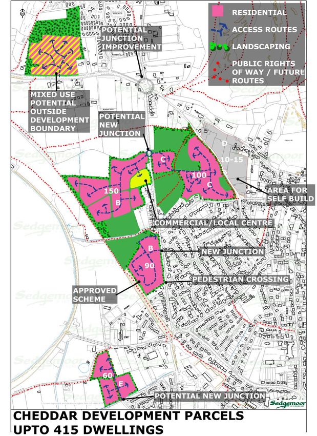
Report Produced by Cheddar Parish Council Neighbourhood Plan Steering Group
www.cheddarplan.co.uk

(This version of the Neighbourhood Development Plan is a draft for public consultation prior to
submission to Sedgemoor District Council, in accordance with Regulation 14 of the
Neighbourhood Planning (General) Regulations 2012).

Cheddar Parish Council
Parish Hall
Church Street
Cheddar
BS27 3RA

01934 743217
clerk@cheddarparishcouncil.org
www.cheddarplan.co.uk

                                                                                      2|Page
Context

This is the 3rd of 10 documents which constitute the Neighbourhood Plan. The first eight
documents are supporting and evidence base documents, the ninth is the Plan Vision and
Policies document and the tenth is the Design Guide.

   1. Report of Community Consultation Events February & March 2013

   2. About Cheddar

   3. Housing Needs and Preferred Sites Report

   4. 2nd Consultation Event November 2014 & Exit Poll June 2016

   5. Appendix 3 Call for Sites Database for Housing Needs and Preferred Sites Report

   6. Employment & Economy Report

   7. Consultation Statement

   8. SDC Consultation Exit Poll 2016

   9. Neighbourhood Plan Vision & Policies

   10. Design Guide

                                                                                    3|Page
Contents                                                               Page

Executive Summary

Introduction

Part A Housing Target

Introduction.

Housing Needs Assessment conducted by Steering Group.
Housing Needs Assessment based on URS Advice Note.
Housing Needs (conclusion from 2nd Consultation event).

Part A - Conclusion Housing Needs.

Part B Potential Development Sites

Introduction.

Call for Sites.
2nd Consultation event conclusion.
Update Additional SDC Consultation & Exit Poll June 30th 2016
Summary of preferred residential sites outside development boundary
Summary of preferred residential sites inside development boundary
Summary of preferred employment sites
Habitat Regulations
Sustainability Assessment
Conclusion

Appendices:

        1       URS Advice Note – Housing need.
        2       Call for Sites – Materials Used.
        3       Call for Sites Database – (See Document 5)

                                                                      4|Page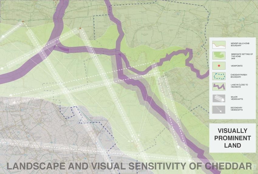
1.0     Executive summary

1.1     A brief summary of the housing needs aspect of this report is that the number of
affordable homes to be built to meet Cheddar housing needs in the plan period 2014 to 2027
should be approximately 10. This is the result of a Housing Needs Assessment (HNA) conducted
by the Neighbourhood Plan Steering Group. Sedgemoor District Council’s Affordable Housing
Team estimates the need as being for 38 affordable homes. It would seem that the range is 10 to
38. Results of the HNA indicate that the need is mostly for one and two bedroom homes.

1.2     The number of houses in total should be in the range 200 to 300, (we consulted on a
figure of 208), and the preferred sites identified here will yield the number of homes to meet the
local needs of Cheddar.

1.3      Since the start of undertaking the Neighbourhood Plan process events have overtaken
the drafting of this report. Planning permission has been granted for 90 new homes on a site,
south of Holwell Lane, which the Neighbourhood Plan did not have as a preferred site. The plan
is for 54 market homes and 36 intermediate ones. Another site, Round Oak Farm, which was
the second choice has outline planning for 110 homes, all shown as market housing on the
application form. However in order to build outside the development boundary 40% of homes
have to be affordable so 44 homes should be expected to be affordable. These two sites
between provide more affordable homes than there is evidence of need.

Should either application not proceed then the Neighbourhood Plan has identified a first choice
site at Helliers Lane. This would provide 67 homes of which 27 would be socially rented.

1.4     With two out of three ‘exception’ sites capable of meeting local need, there will be no
requirement to build on all outside development sites. This is especially true as inside the
boundary development sites, namely Steart Bushes and Steart Triangle that could come forward
quickly would themselves provide a further 50+ homes without small infill sites coming forward.
Other sites at WC Maunders and Ashley Lane/ Hopwoods could provide a further 64 homes if
they came forward in the plan period.

1.5     Cheddar has a higher proportion of detached houses than both the Somerset and
national averages. Future developments could provide more semi-detached and apartment
family homes to meet the needs of families, small households and downsizing.

1.6     Two sites have been identified as being preferred sites for providing employment
opportunities in the future, helping to keep housing and employment opportunities in
proportion and therefore increase sustainability and reduce outward movement to seek work.
Those sites are known as the Yeo Valley site and the land west of Cheddar Business Park, where
Sainsbury’s had planning permission prior to relocating to an existing store within the village.

1.7     The current Local Development Plan, The Core Strategy, is under review and proposals
are being consulted on until August 8th 2016, the proposals are noted and used in this report.

                                                                                      5|Page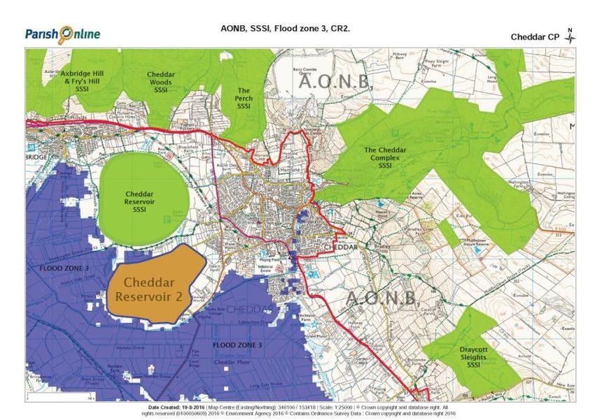
2.0     Introduction

2.1      This report is the conclusion of three key pieces of work, a whole village housing needs
assessment survey, a call for sites exercise, and desk top research of sites identified in the
District Councils Strategic Housing Land Availability Assessment (SHLAA). The conclusions drawn
here are also informed by the public responses to the Neighbourhood Plan second consultation
event, and the exit poll exercise and these are more specifically detailed in a separate document,
Second Consultation Report (Document 3).

2.2     The Sedgemoor District Council SHLAA dated November 2014 and updated in February
2016 are available at www.sedgemoor.gov.uk. Assessing and proving a local housing need is the
key deciding factor for development, as Policy P4 of the SDC Core Strategy only allows for
development outside and adjacent to the development boundary as an exception site needed to
meet a proven local need.

2.3     This report is written in alignment with the District Council’s Local Plan called the Core
Strategy 2006 to 2027. It is noted that the Core Strategy is under review and that there was a
Regulation 18 Consultation which closed on January 18th 2016 and an additional consultation run
from June 27th to August 8th 2016. The consultation on the new Local Plan has been taken into
consideration throughout this report, although the final content of a new Local Plan cannot be
known.

2.4     The additional consultation event in Cheddar on June 30th 2016, showed the proposed
new development plan for Cheddar and development sites that were being put forward. An exit
poll was taken of attendees views regarding the proposals, and the summary of that poll can be
found in the second consultation document. (Document 3). The proposals in the additional
consultation have been used to inform this report.

2.5    The Report is in two parts. Part A summarises the housing needs work undertaken to
determine a housing target for Cheddar whilst Part B identifies and summarises all potential
development sites in Cheddar, those for housing and those best suited for providing
employment opportunities and securing economic sustainability.

2.6      The Steering Group took advice from URS Consultants, planning consultants, and the
opinion expressed was that if their advice indicated a smaller quantum of need than there was
suitable land available, then sites should be scored or ranked to indicate which are the preferred
sites for the development needed, and the remainder either discounted or safeguarded for
future use as appropriate. This report follows that advice and links potential housing need with
supply of suitable sites. The URS Advice Note can be found in Appendix 1.

                                                                                       6|Page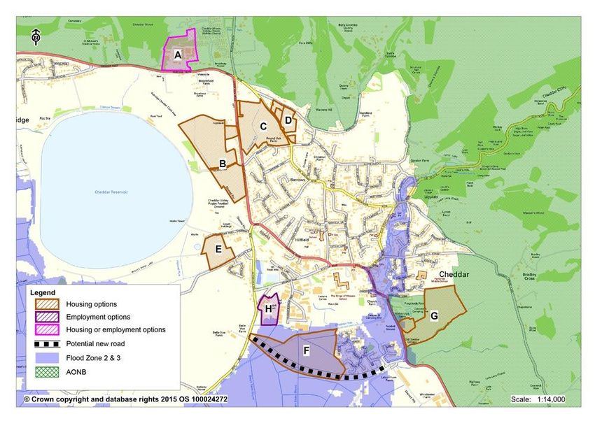
2.7 The Vision for Cheddar is:
‘Cheddar will retain its identity as a village, within an attractive setting of surrounding
rural landscape and hamlets. Its distinctive local character will be maintained and
enhanced. Cheddar will be a sustainable place, providing an outstanding quality of life
for current and future generations and will continue to be a visitor destination of
regional, national and wider significance’.
2.8 The Principles behind this Vision are:
That Cheddar continues to be compact, avoids ribbon development and retains its
village feel.
The openness and beauty of the countryside around the village will be preserved whilst
retaining Cheddar’s role in enabling a working rural economy.
That the village functions as a varied retail, employment and service centre for its
residents and nearest neighbours.
That the village recognises the economic and employment value of Cheddar Gorge and
Caves and the businesses associated with its unique location.
That it provides safe routes for people by improving footpaths and cycle ways and
controlling the impact of traffic.
2.9 Cheddar is situated in the north eastern part of the District and its future growth and
development is constrained by the topography of the area. To the north is the scarp slope and
plateau of the Mendip Hills all of which is designated an Area of Outstanding Natural Beauty. To
the south are Cheddar Moors, a low lying area in Flood Zone 3. The River Yeo, arising from
Cheddar Caves is also in Flood Zone 3. These natural constraints and the desire expressed in the
Vision for Cheddar and the underlying Principles to keep the village compact and prevent ribbon
development along the scarp slope in particular, limit how and where development can take
place.
7|Page
Map1 Flood Zones (Source Environment Agency)

Light blue Flood Zone 2
Dark blue Flood Zone 3

2.10 The impact of development on the visual outlook from the sensitive sites on the Mendip
slopes, and along the main roads, are also a key considerations with regards to which sites could
be best described as ‘preferred sites’ as their visual impact should be the lowest. However
Cheddar is not only viewed from the Mendips, it is highly visible from the south too. The village
is visible from Glastonbury Tor and from a long way south on the A38 especially at night when
lighting ‘spillage’ detracts from the darkness of the Mendip hills, especially on the lower slopes.
Development should respect these visual impacts over a great distance as well as in the direct
locality.

                                                                                        8|Page
Map 2 Visual Sensitivity Map of Cheddar. (Source AONB Landscape Officer)

2.11 The sensitivity of visual impact is illustrated in Map 2. The impact along the main roads
into and out of the village is especially significant. Every part of the A371 and B3151 in Cheddar
is visible from the AONB. The major view shafts from 3 prominent viewpoints are indicated on
the map as well as secondary ones. The whole village is visible from two of the points and the
map shows clearly that the whole parish is visible from the AONB.

2.12 The Neighbourhood Plan Steering Group undertook a Call for Sites exercise in 2013. It
was important to know which potential development sites were or could become available so
that a second consultation event could be arranged to ask Cheddar residents for their preferred
sites as and when development took place, which would help inform the preferred site options
for this Neighbourhood Plan.

2.13 The Steering Group undertook desk top research and used the Sedgemoor District
Council’s Strategic Housing Land Available Assessment (SHLAA) undertaken originally in 2009 and
updated in November 2014. Each potential development site identified from the call for sites
and SHLAA research has been assessed using the criteria on the SDC sites assessment pro forma,
supplemented by field work and local knowledge. The sites assessment sheets are in Document
5 Appendix 3 – Call for Sites Data, a separate document for ease of use.

                                                                                       9|Page
2.14 Sedgemoor District Council in 2015 undertook a consultation for adjustments to the
development boundary in Cheddar. The suggested boundary changes are minor adjustments in
order to mostly reflect garden boundaries and changes for accuracy. This review is part of the
work being undertaken regarding the Development Boundaries for Key Rural Settlements,
however it is work based on the assumption that Cheddar is ‘elevated’ to a Tier 1 settlement and
not a Key Rural Settlement in the new Local Plan.
2.15 With regards to the Neighbourhood Plan, the boundary change proposals in the review
have little impact, as the sites under consideration remain either within, or outside, the
development boundary as it exists and also as proposed.
2.16 This call for sites work has been carried out to help inform the Neighbourhood Plan and
the preferred option sites that have been put forward as Neighbourhood Plan policies.
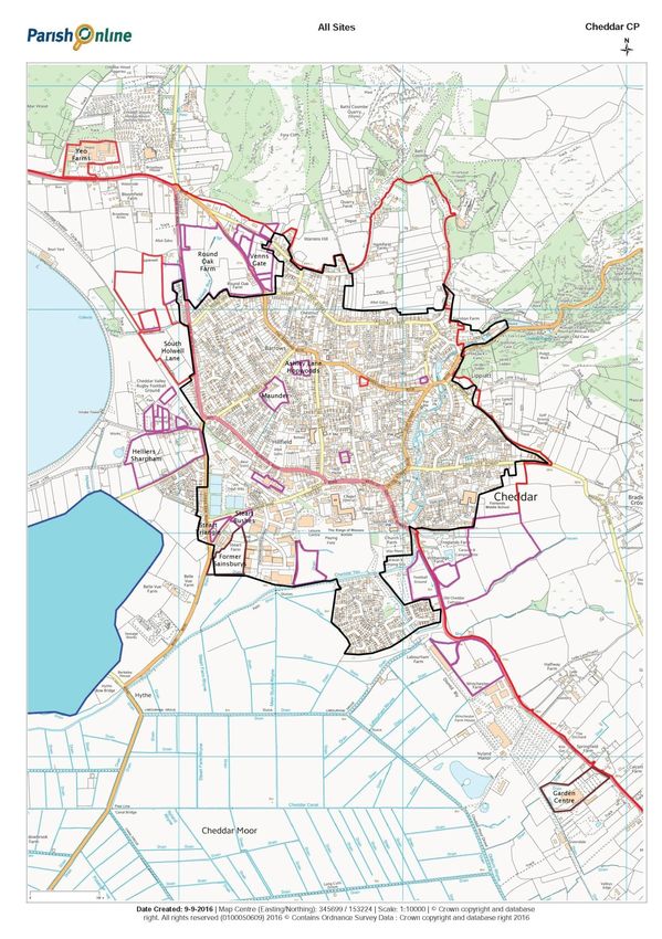
Map 3. Proposed Development Boundary, showing minor changes.
10 | P a g e3.0 Introduction - Housing Target
3.1 National Planning Practice Guidance (NPPG) concedes that establishing housing need is
not an exact science and no single approach will provide a definitive answer. As a consequence a
series of pieces of work and desktop research have been undertaken to arrive at a housing target
the Steering Group considers to be appropriate to put forward as a Neighbourhood Plan Policy.
3.2 The current Core Strategy to 2027 states as the 17 Key Rural Settlements (KRSs) of which
Cheddar is one, should take 1260 (excluding local housing priority sites as defined in policy P4)
new homes during the plan period 2006 to 2027. This amount is not allocated in any way and so
there is no specific housing target for Cheddar. The Steering Group needed to establish a robust
affordable housing requirement as a starting point, as the SDC Core Strategy states that sites
must provide a proportion of affordable housing on each site built out. Knowing the affordable
housing need would then allow calculations to determine how many houses should be built
proportionately to meet that need.
3.3 Since 2011 100 affordable homes have been built outside the development boundary
under SDC Policy P4 which allows for exception sites to be developed to meet local need. The
Helliers Lane development consists of 77 homes, 34 of them rented, 22 shared ownership and
21 low cost home ownership units. The Sharpham Road development is all socially rented
housing. Both sites are covered by S106 agreements. The Helliers Lane homes were occupied
between September and November 2011, and the Sharpham Road ones in December 2015.
3.4 The S106 agreements (précised) state houses should go to those in need of such
accommodation (in cascading order of priority) who:
Have immediately prior to having a house allocated have been resident in Cheddar for 5
years
Have a strong local connection with the parish a) has immediate 1 generation up or 1
down family association who have lived in village for 3 years or b) has any significant
past periods of residence in the parish of at least 1 year or c) 1 generation up or down
has a member of the household in permanent employment in the parish
If not then: to Shipham, Priddy, Draycott, Wedmore, and Axbridge as above in the same
cascading order of criteria.
3.5 With 100 affordable homes having been built and occupied to meet local housing need,
the concern is that Policy P4 could be overused and allow market housing to use the ‘affordable
housing’ ‘rule’ outside the development boundary, as the way of accessing such sites .
The role and function of Cheddar is not to provide affordable housing for the whole of the north
eastern part of the District. It has been defined as a Key Rural Settlement (KRS) along with 16
other settlements under Spatial Strategy Policy S1. The definition of a KRS is that it offers the
greatest opportunity for appropriate sustainable development. Our nearest neighbours
Axbridge and Wedmore are also defined as KRSs as they too provide for the ‘day to day needs of
rural communities’. Both have an affordable housing need of their own.
11 | P a g e3.6 On March 21st 2016 a new document, Role and Function - Review of our settlements
services and facilities, dated September 2015 was published. This document shows Cheddar no
longer as a Key Rural Settlement but as a Tier One settlement. The first Regulation 18
Consultation for reviewing the Core Strategy closed on January 18th 2016 and an additional
consultation was run from June 30th to August 8th.There was no specific questionnaire associated
with either of these consultations and SDC officers were required to take verbal feedback or
make notes if they could. An exit poll of the additional consultation on June 30th was
undertaken to inform the Neighbourhood Plan and the results can be found in Document 3, the
2nd Consultation document.
3.7 The Regulation 18 consultation was also about possible housing numbers and potential
development sites, all of which were outside the development boundary. The map showing the
potential sites did not indicate where the development boundary was. As a new local plan is
some way off, this Neighbourhood Plan report on housing needs and sites continues to refer to
Cheddar as being a Key Rural Settlement.
3.8 The Core Strategy does not apportion the 1260 housing target for the 17 Key Rural
Settlements, but if it were just equally divided then Cheddar would expect to receive 74 new
homes in the plan period to 2027. Excluding the built 100 affordable homes another 121 new
dwellings have been built or converted since the start of the draft Core Strategy Plan, taken as
being January 2006 to October 2015. Extant plans plus those currently under consideration
account for a further 285 new dwellings in the planning system that are likely to come forward
on both inside and outside boundary sites. All residential planning applications granted or not,
are listed in Appendix 2 of Document 2, About Cheddar.
3.9 The Steering Group conducted its own housing needs assessment to ascertain local
affordable housing need. It also commissioned advice from URS (see appendix 2) with the
assistance of Planning Aid England who was offering the Group support. The aim was to receive
professional comment on our housing need; both affordable and market housing.
3.10 NPPG guidance states that the assessment of development needs should be an objective
assessment based on facts and unbiased evidence. Plan makers should not apply constraints to
the overall assessment of need, such as limitations imposed by the supply of land for
development, historic under performance, viability, infrastructure or environmental constraints.
The Steering Group have used the URS consultants advice note, its own research and SDC
available material to inform this document and are conscious of the above guidance and believe
this report adheres to that.
12 | P a g e4.0 Housing Needs Assessment conducted by NP Steering Group
4.1 It proved difficult to arrive at a robust housing need for Cheddar when the Steering
Group asked the Affordable Housing Team at SDC for data. Following a request for the number
of households in local need, the Affordable Housing Team in November 2012 interrogated the
Choice Based Letting system (the waiting list) and performed a ‘mini survey’ of the 177
households on the CBL. An officer telephoned each of the households all of whom had stated a
preference for a home in Cheddar. However in February 2016 an update briefing document
produced as evidence regarding a specific planning application, was published. This is called
‘Cheddar Parish “Mini” Housing Needs Assessment Review of November 2014 Report’. It states
that the 2012 ‘mini’ survey was no less a valid survey following the same rigorous methodology
and assessment criteria used when carrying out a traditional ‘full’ parish wide HNA.
4.2 The response to the original request for data arrived in July 2013 as a verbal report that
57 applicants had responded to the ‘mini survey’ indicating a preference to live in Cheddar.
4.3 The February 2016 review of the 2014 mini survey of the 2012 data document states
that 41 affordable homes were required in November 2014 prior to the occupation of the 23
homes on the Sharpham Road development. However the point is then made that only 3 people
out of the 41 families were allocated a Sharpham Road home therefore 38 remained in need of
an affordable home. It makes no sense that 12 homes would need to be built so that each of the
38 families had a chance of moving into an affordable home in Cheddar.
4.4 It would seem that either the ‘wrong’ mix of homes was built to meet the identified
need or the assessment of ‘local need’ was such that Cheddar residents were somehow not
given priority.
4.5 In light of the lack of robust data in July 2013 on the actual ‘local need’ for housing in
Cheddar, as against a desire to live in Cheddar, the Steering Group conducted its own specific
housing needs survey. The survey used the same methodology and survey material as that used
by SDC when it conducts such a survey.
4.6 It was decided to leaflet every household within the Cheddar BS27 postcode area,
delivered by Royal Mail, advising them that we were conducting a housing needs assessment.
Additional advertising was carried out through press releases to the local paper, the local radio
station, and through social media to attract the difficult to reach younger generation. The period
for collecting the data was from 15th August 2013 through to the 18th November 2013 a period
of 15 weeks. The date and period of the survey was chosen to ensure that people away on
holiday or out of the area would be included. The survey was offered either in paper form or via
an online portal through www.cheddarplan.co.uk
13 | P a g e4.7 The numbers registering were monitored daily, to ensure that we received as many
responses as possible. The period was extended from the initially advertised period, as
registrations were still occurring at the closing date, and it was considered very important to
capture all in need. The use of the web-based system to carry out the survey enabled people
that were in other areas of the country, or even abroad to take part in the survey without
prejudice. A commercial Survey package (BFSurvey Plus from Australian company Tamlyn
Software) was utilised, as it allowed secure handling of personal data without having to reside
on the web, in compliance with the upcoming new legislation.
4.8 The assessment took the form of a single survey, no follow-up questions or interviews
were conducted, although applicants had been requested to provide their e-mail addresses and
telephone numbers. The survey included an additional question, to the questionnaire used by
Sedgemoor for such surveys, asking if any additional persons were known to have a housing
need that may not have been contacted within the initial mail shot. This yielded one named
person, who was contacted but failed to respond or complete a questionnaire.
4.9 The outcome of the housing needs survey was:
There were 77 responses
12 households stated they had a housing need
Of these two had been in Cheddar for less than 1 year having previously resided in
North Somerset, and Reigate/Banstead areas.
One requested Residential Care housing.
One requested Housing with support services.
Two requested housing on the ground floor.
Two stated they would buy on the open market.
Four would prefer to buy as a shared equity with the local authority or housing
association.
One would prefer to rent from the private sector.
4.10 Two responders stated they would buy on the open market, these were removed from
the affordable housing need numbers. This left a total need for affordable homes of 10 units.
4.11 The stated room requirements for each of the acknowledged ‘in need’ respondents are
shown in Table 1.
Table 1 Affordable Housing Need
One Bedroom Two Bedroom Three Bedroom
3 Homes 5 Homes 2 Homes
14 | P a g e4.12 The conclusions are that the residents of Cheddar have a requirement for ten affordable
homes, of which two should be of an affordable sheltered accommodation/residential care type
unit. Two further responders had requested ground floor or bungalow accommodation.
4.13 The Housing Needs Assessment conducted by the Steering Group was in accordance
with the SDC methodology. To confirm the survey was robust the results have been compared
with recent surveys (2008 to 2015) conducted in other Key Rural Settlements, either directly by
SDC or the Communities Council in conjunction with the respective Parish Council. See Table 2.
4.14 The response rate for the Cheddar Housing needs survey, with 77 can be seen to be
above the average of other KRSs with the exception of Mark, which took a more ‘hands on’
approach to collecting date. It is even higher than the 57 responses SDC achieved when they
specifically contacted the 177 people on the CBL list for the ‘mini survey’.
4.15 The identified need of 10 affordable homes was in line with other surveys, even though
it followed the occupation of 77 affordable homes at Helliers Lane. This could indicate that in
less than a year the Helliers Lane development had housed people from the widest definition of
a ‘local’ area, as 10 households being in need was the proportion one would expect if there had
been no provision made. Table 2 also shows the number of affordable homes known to have
been built.
15 | P a g e4.1 Table 2 Housing Needs Assessments undertaken since 2008 in Key Rural Settlements.
(Source SDC 2014 and the appropriate Town and Parish Clerks March 2016)
Place Survey Date Survey Responses Required Need Provided
Instigator (Post 2010)
Ashcott November 2013 SDC 15 10 0
Axbridge October 2015 SDC 41 25 0
Berrow September 2010 PC Com Council ? ? 0
Brent Knoll June 2013 SDC 8 8 0
Cannington July 2014 SDC 20 14 0
Cheddar January 2014 NP group 77 10 100
East Huntspill October 2008 PC Com Council 8 8 19
Lympsham May 2008 Com Council 6 4 0
Mark March 2014 SDC 118 10 0
Nether Stowey March 2009 PC Com Council 23 23 20
Nth Petherton July 2014 SDC 37 33 ?
Pawlett August 2011 PC Com Council 12 12 ?
Puriton June 2015 SDC 72 29 49
Wedmore January 2014 SDC 31 14 0
*Wembdon 48
Westonzoyland ? ? ? ? 3
Woolavington July 2014 SDC ? ? 16
*Wembdon, SDC Core Strategy Policy S1, although identified as a KRS this is part of the larger
urban area of Bridgwater.
16 | P a g e5.0 Housing Needs Assessment.
(Based on the advice note from URS see Appendix 1)
5.1 Using different methodologies URS calculated a series of housing target figures. For total
housing need the simplest method was to contact SDC and ask what the residual housing target
was for the KRSs part way through the plan term. The URS consultant calculated that between
them the 17 KRSs had a residual need of 395 houses between 2014 and 2027. In proportion to
the KRS populations, Cheddar’s residual housing target would be just 57 dwellings in that time
frame.
5.2 Using historical data as a guide to future development was another method used to give
guidance on a housing target for Cheddar.
5.3 Historically Cheddar has grown from 2292 dwellings using 2001 census data to 2543
using 2011 data, an increase of 251 dwellings in a decade. Whilst historic development is not an
absolute guide to future development it is, in the absence of a Core Strategy target, a good guide
to the pace of growth which a settlement has previously accommodated.
5.4 These two figures of 57 and 251 each provide some statistical data to determine a
possible housing target however they do not take into account population growth.
5.5 The NPPG recommends that household projections should be used in the assessment of
housing need. The household numbers projected for Sedgemoor in 2021 is 54,000. Projecting
this forward to 2027 the figure becomes 57,426, thus indicating the formation of 7,426 new
households across Sedgemoor between 2014 -2027. Cheddar represents 5.02% of the total
households in Sedgemoor using 2011 census data. With 0.963 households per dwelling this
would translate into a requirement for 359 new dwellings in Cheddar by 2027.
In order to determine an overall housing target for Cheddar, URS took the projected forward
figure of 359 homes and added Cheddar’s portion of the residual KRS need of 57 and
determined the total by adding them together, then the midpoint was arrived at by dividing by
two. This equates to a housing target of 208 additional households being the planned target for
Cheddar between 2014 and 2027.
5.6 The figure of 208 is regarded as a realistic overall figure but there is uncertainty about
the affordable housing target as a proportion of the overall housing target.
5.7 URS report that determining affordable housing need is difficult as Sedgemoor’s policy
of determining its affordability target is effectively on a site by site basis. URS conclude that as
Sedgemoor’s development management team will continue to determine affordable housing
proportion within the parish on a site by site basis even after the Neighbourhood Plan is
adopted, the Neighbourhood Plan need not formulate an affordable housing policy of its own.
However the Neighbourhood Plan does have to have an affordable housing target in order to
17 | P a g edetermine how many sites would need to be developed to meet local need in the plan period to
2027.
5.8 Core Strategy Policy P4 states that out of boundary development sites adjacent to the
boundary can be developed to meet local need as exception sites, those that would otherwise
not be released for development. The concern is that all the identified sites outside the
development boundary could use this policy and that ‘exception’ will mean nothing. As
developers are required to build affordable housing into their development as a proportion of
dwellings then having an affordable housing target is essential to determine how many sites
could be developed to meet a robustly identified local need.
5.9 Sedgemoor’s policy on affordable housing is that from 2016 all sites of 5 to 9 dwellings
should designate 20% of the development as affordable housing. This raises to 30% on sites of
10 to 14 dwellings. There is no target for fewer than 5 dwellings. Sites providing 15+ dwellings
should contain 40% affordable homes.
5.10 URS noted that the Steering Group’s housing needs survey was representative of the
parish as a whole and the *9 households identified as being in need of an affordable home is
11.69% of the 77 responders. Cheddar Parish had 2449 households in the 2011 census, 11.96%
of that figure is 286 households. However this is a gross figure, if all the households were added
to the Sedgemoor housing waiting list (and many, if not most, of them may be on the waiting list
already) they would be classified as ‘emergency’ gold’ ‘silver’ and ‘bronze’. It is standard practice
to discount the ‘bronze’ category as ‘housing waiting lists tend to overestimate demand as
households put themselves forward when their level of ‘need’ for affordable housing is not
actually that great. For example, households may put themselves forward for inclusion as a form
of insurance in case of their circumstances changing and are therefore clearly not currently in
‘need’ in a priority sense.’ (GVA Grimley’s 2011 SHMA for Leeds City but applies equally to
housing needs assessment elsewhere).
*minor error in earlier communication, should read 10, however not a material difference in the point being made.
5.11 This is also the approach of the Sedgemoor Strategic Housing Market Assessment
Update (SHMAU): it states that if all households in housing need were to be provided with an
affordable home, it would be significantly above likely (or realistic) levels of affordable housing
delivery.
5.12 A route to establishing local affordable housing need undertaken by URS was based on
the Strategic Housing Market Assessment Update – March 2014 commissioned by SDC. The
number of households in unsuitable housing in Sedgemoor as a whole was estimated to be
1056. Around 71% of the 1056 households were estimated to be likely to have insufficient
income to afford market housing and so the total backlog need was reduced to 749 households
in Sedgemoor.
18 | P a g e5.1 The SHMAU does not refer directly to Cheddar, it uses the context of the North East
Rural sub-area, called Axevale, which consists of Wedmore, Mark, Axbridge and the Cheddar and
Shipham wards. As a proportion of the Sedgemoor total the backlog need for all of the North
East subarea is 65.
5.14 The SHMAU then calculates the newly arising need that is the estimated level of housing
need from newly forming households, which was determined to be 296 households in the NE
sub area between 2013 – 2018, (in other words households not currently on the waiting list).
Adding the backlog need, the need from newly forming households and existing households
falling into need and deducting the supply of affordable housing creates an affordable housing
need in the NE sub area of 322, across all the wards.
The total number of households in the NE sub area is 6539, 37.42% of which are in Cheddar.
On this basis Cheddar’s net affordable housing need 2013 – 2018 is 37.42% of 322 =120
households.
5.15 The URS advice note points out that there is a significant disconnect between the Core
Strategy and the national household projections on the one hand and the stated affordable
housing need on the other. The affordable housing need appears to be far greater, even after it
has been discounted according to standard housing assessment practice, than the figure of
which it should in theory form a proportion of (i.e. market as well as affordable). For example
the 120 households stated as being in need of affordable housing 2013 -2018, translates into an
average annual requirement of 24 affordable households per year. Projecting forward affordable
housing need on this basis 2014-2027 gives (24 x13 years) =312 households in need of affordable
housing over the remainder of the plan period. The figure 312 significantly exceeds the ‘total’
housing need of 208 over the same period, whereas one would normally expect to find
affordable housing need as a proportion of the overall total.
5.16 Even if the absolute highest estimate of total need for Cheddar were applied, namely
359 households based on Cheddar’s portion of the DCLG household projection, the 312 houses
in need of affordable housing would still form 87% of housing need, which is far in excess of the
Core Strategy affordable housing parameters of 15 -40% and would also render most housing
development unviable.
5.17 High levels of affordable housing need can be used as the rationale behind the use of
exception sites both in Sedgemoor and elsewhere. NPPF paragraph 17 makes it clear that all
housing need must be provided for. NPPF paragraph 54 allows for the use of exception sites to
reflect local needs, particularly for affordable housing.
5.18 URS state that their advice note has uncovered a lack of clarity in terms of Cheddar’s
affordable housing waiting list and how it relates to the overall housing need, at the moment the
affordable housing need from the waiting list alone appears to exceed overall need, whether
based on the core strategy or on DCLG projections. The discrepancy between the two figures at
present suggests it would not be realistic or desirable to meet all the stated affordable need
through exception sites, as they would risk no longer being exceptions.
19 | P a g e5.19 It has proved very difficult to arrive at a robust housing need for Cheddar despite using
several sources and commissioning professional advice from URS. It is important to establish
this as developers will use the need to build affordable homes as the reason to put forward plans
for sites that should be ‘exceptional’ but will not be if all of them are developed, and this
becomes the norm.
5.20 The SDC ‘mini’ survey concluded that 41 households were looking for affordable housing
in Cheddar, all of whom had some form of Cheddar connection. The report said that the figures
did not include the 23 affordable homes which were built but not yet allocated at Sharpham
Road (these units were allocated November 2015). In the end only 3 families out of the 41 had a
house allocated. There were also a further 10 respondents with an unmet housing need with an
18 months to 4 year connection to Cheddar.
5.21 The SDC figures above conclude that there were 41 + 10 people with a local connection
waiting for affordable housing, and since then the 23 Sharpham Road houses have been
occupied. That would give an unmet need of 28 affordable homes using this mini survey.
5.22 SDC asserts that: “Cheddar provides important services to residents living in
neighbouring parishes. One function could include the provision of affordable housing. Many of
the neighbouring parishes may not have the planning policies nor access to the requisite public
funds to bring forward new affordable homes in their own parish. Residents seeking affordable
homes in these parishes are likely to look to Cheddar for a solution.”
5.23 This assertion would put pressure upon Cheddar to accept having greenfield sites
developed whilst simultaneously denying residents in other villages from having a home where
they currently live or may wish to live. This will skew the age demographic for every village
within the area, with the potential for communities to lose their young, as they are forced to
move into accommodation in places other than where they grew up and have existing support
networks.
5.24 Our neighbouring KRSs share the overall planning policies of the Core Strategy so there
is no requirement for them to have ‘their own planning policies’ and there are no parishes with
the ‘requisite public funds to bring forward new affordable homes’ in any parish. The District
Council is currently consulting on classifying Cheddar as a Tier 1 settlement above its
neighbouring villages, which will continue to be identified as KRSs. As no parish has access to
public funding for affordable housing or planning policies unique to them, the argument that
these are the reasons only Cheddar must take affordable housing is not sound. In future all
affordable housing is likely to be just a proportion of a larger privately developed scheme and
the greenfield sites around Cheddar will all be built on if the above assertion is accepted.
5.25 In considering the figures presented by SDC in their mini-HNA, there is little to suggest
that the figures are robust, as the method behind their determination fails to meet nationally
accepted methods for the determination of housing need, and it relies on underlying data from
at least 2008. It is concluded that the affordable housing target for Cheddar residents is
approximately 10 units.
20 | P a g e6.0 Housing Needs conclusion from Second Consultation event
6.1 Whilst this housing target and site consultation is covered in detail in a separate
document (Document 3, 2nd Consultation Report) the key elements of it are recorded here and
the preferred development sites have been covered in Part B of this report.
6.2 In order to gauge public opinion on the amount of potential development Cheddar
might take up to 2027, a range of options drawn from the figures above and other research were
presented. The reason for not having a ‘zero’ option was explained on the survey and associated
display boards ie that there would be some building in the time frame so zero could not be a
viable option. The URS figure of 208 was highlighted and put in the range of 200 to 300. A
controversial move as it would imply the Steering Group was encouraging up to 300 new houses
to be built. However a plan up to 2027 could not ignore such a possibility as the number of
extant plans and potential reapplications that could come forward could reach close to 300.
6.3 The overwhelming response was that Cheddar should expect to take between 200 and
300 houses within the plan period.
21 | P a g e7.0 Conclusion - Housing Need
7.1 It can be seen that there is a range of figures in this report which all identify a housing
need for Cheddar. We have a range from 57 to 395 in total from various sources and projections.
7.2 The Neighbourhood Plan policy that has emerged from this work is that the affordable
housing target for Cheddar is currently approximately 10 units. We will review affordable
housing needs numbers every 5 years.
7.3 For market housing the conclusion of this work is that the number of new houses in total
in Cheddar to the end of the plan should be in the range 200 to 300 (2014 - 2027).
7.4 This range takes into account the projected forward figure but also the public’s concern
that the village should not grow by more than 200 units in the plan period. It is a defensible
range based on the final figure provided by URS of a total target figure of 208 and accounting for
extant permissions and potential renewals.
22 | P a g eConclusion - Housing Requirement
7.5 The Strategic Housing Market Assessment Update March 2014 broadly summarises that
the housing requirement for Sedgemoor as a whole is that the following house size number is
required to meet housing needs:
1 bedroom -6%
2 bedroom -35%
3 bedroom -36%
4+ bedroom -24%
7.6 Cheddar is in a section of the District called the North East sub area and the defining
housing criteria for the sub area can be summarised as having:
The highest proportion of detached housing -57.6%
The second lowest proportion of flats – 9.1%
The highest average housing values based on council tax banding
The second lowest vacancy rates -4.15
The lowest percentage of over-crowding – 1.4%
The highest rate of under occupation – 53.7%
The highest average annual incomes -median £27,412, mean £36,040
The highest lower quartile house purchase price - £209,000
The highest lower quartile private rents -£550
7.7 This list indicates the relative differences between the North East sub area and the rest
of Sedgemoor. This informs the Neighbourhood Plan in that it confirms the NE sub area is a
desirable location to live and where residents can afford higher house prices. However there are
variations within the sub area and the data below is indicative of this.
7.8 Data from Rightmove (July 2016) indicates that Cheddar in particular has:
An average sale price for all house types of £257,657
This is lower than neighbouring Axbridge which has an overall average house price of
£290,979
Both of these are lower than neighbouring Wedmore with an overall average house
price of £431,797
Sold house prices in Cheddar were up 5% on the previous year and similar to the 2013
level of £251,720
7.9 Whilst Cheddar is a desirable place to live it is not the most expensive of the three
neighbouring villages. The affordable housing need for both Axbridge and Wedmore has not
been met whilst Cheddar has planned for, and built a very high number (100) affordable housing
units in order to offer a wide range of housing for its residents.
23 | P a g e7.10 Being a rural settlement Cheddar has little terraced housing associated with
industrialisation as urban areas are more likely to have. Terraced housing here comprises very
old cottages, some Victorian villas or some terraces on recent developments. Terraced housing
accounts for just 11% of the total housing. The market price is indicated below for such housing.
7.11 For a rural community Cheddar has virtually the same proportion of purposes built flats
(9.9%), as in Somerset as a whole, at 9.2%. There are fewer flats as the result of conversions than
the county as a whole, however 1 and 2 bed flats are available at similar prices for the same
quality as other places in Somerset, including the urban and ‘cheaper’ area of Bridgwater.
7.12 As an example the figures below are taken from Rightmove and show the prices of some
of the completed sales in Cheddar in March 2016:
1 x 2 bed terraced (retirement restriction) £128,000
1 x 5 bed detached £410,000
1 x 3 bed semi-detached £230,000
1 x 2 bed flat (leasehold) £169,000
1 x 2 bed flat £108,000
1 x 2 bed flat £121,000
1 x 4 bed terrace £272,500
1 x 4 bed semi-detached £262,000
7.13 Planners and developers will need to consider the above information when determining
which plans best suit the needs of the village, as sales prices are indicative of the demand for
particular types of housing. Prices are not exceptionally high for Cheddar despite the argument
that there is an exceptional need for a lot of extra affordable housing here, a need that is broadly
reflective of the housing market as a whole. The demand for affordable and first time buyer
housing is a national one. The Neighbourhood Plan for Cheddar is not advocating that out of
development boundary ‘exception sites’ should be developed to address an affordable housing
need for the North East sub district, rather that each of the neighbouring villages should address
their affordable housing needs. Both Wedmore and Axbridge are working on producing their
own Neighbourhood Plans which would be expected to address local housing need.
7.14 The high rate of under occupation may be indicative of the ageing population of the
village and it could be ‘hiding’ a need for smaller housing for people to down size into.
7.15 It should be noted that a 37 bed dementia care home has been built recently, replacing a
less suitable building. Attached to this are 22 flats for people who are dependent on having
some help with their daily needs and 11 other purpose built, quality sheltered flats for the open
market, some of which are still unsold after 2 years.
24 | P a g e7.16 Cheddar does offer specific retirement/sheltered housing. Specialist places include;
Cheddar Court, with 56 flats both 1 & 2 bed and resident management staff. These are
leasehold units for sale
Penn Close, 35 flats and bungalows both 1 & 2 bed offering visiting support and many
social facilities. These are rented from social landlord and SDC.
The Homestead, 36 flats studio, 1 and 2 beds. Resident management staff. These are
rented (social landlord)
Wellington Place, 29 flats and 1 house. Both 1 & 2 bed. Support from visiting staff.
Rented (social landlord and SDC)
7.17 The housing requirement for Cheddar can best be summed up as following the national
trend. The Neighbourhood Plan includes further development to meet demand. That demand
is best met by using within boundary sites primarily, some of which have extant plans and to use
as few as possible outside boundary sites to meet specific proven local need. The vision for
Cheddar is that it remains compact and not linked by ribbon development to its neighbours, to
achieve this outside development boundary building should be very restricted.
7.18 This report has not focused on small infill sites which could yield one or two units, yet
such sites over the plan period would go some way to meeting the 200 to 300 new homes that
the Neighbourhood Plan Policy proposes.
25 | P a g e8.0 Potential Development Sites
Introduction
8.1 Cheddar has been recognised in the Sedgemoor Core Strategy Spatial Strategy Policy S1
as one of 17 Key Rural Settlements (KRSs). The strategy is that these KRSs should provide 12%,
of the identified number of additional homes and jobs in the District from 2006 to 2027, the
Core Strategy period (table 3.2 of SDC Core Strategy). This equates to 1260 houses being built in
the plan period. Of these 664 (table 3.3 of SDC Core Strategy) were still required in the 2010 to
2027 period since the publishing of the Core Strategy. Working from this figure URS calculated
that at September 2014 the outstanding number of houses still to be built was 395 across all the
KRSs 2014 to 2027.
8.2 There are no distribution criteria given in the Core Strategy, just the overall housing
need of 1260 for the District and therefore no specific housing figure for Cheddar is indicated.
8.3 The Steering Group undertook research of potential development sites within the village
development boundary and outside it, as Policy P4 of the SDC CS states:
'Housing proposals for redevelopment, infill, subdivision and conversion within existing
settlement boundaries will be supported where appropriate to the scale, design and character of
the existing community.
Outside of the settlement boundaries of the identified Key Rural Settlements ….housing proposals
on sites specifically released for that purpose will be supported where it is demonstrated that it
meets all of the following:
Fulfils an identified local housing need for affordable and market housing as evidenced
by a Local Housing Needs Assessment …....................'
8.4 The SDC Affordable Housing Officer has informed the Steering Group that there is still a
great demand for housing in Cheddar as indicated by the choice based letting list. The two
recent developments consist of 67 affordable rented houses plus 10 affordable (80/20) market
houses at Helliers Lane, completed in 2012 and 23 affordable homes at Sharpham Road
occupied in December 2015. A total of 100 affordable homes have been built in Cheddar in the
last five years, all of them outside the development boundary and using the Policy P4 exception
as the justification ie ‘to meet local need’.
8.5 It is appropriate that all potential sites be considered for this Neighbourhood Plan, both
inside and outside the boundary as the National Planning Policy Framework (NPPF) paragraph 14
states 'At the heart of the National Planning policy Framework is “a presumption in favour of
sustainable development”. It is known that there is no specific housing target for Cheddar
determined by the District Council, however the Neighbourhood Plan has a housing target in the
range 200 to 300 and sites may become available in any chronological order, with inside the
boundary ones not necessarily becoming available until near the end of the plan period.
However the Neighbourhood Plan aim is to inform the District Council and potential developers
so that the village grows in an appropriate and sustainable way.
26 | P a g e9.0 Call for Sites
9.1 The Steering Group undertook desk top research of the SDC website's reports on land
availability in Cheddar.
9.2 Sedgemoor District Council undertook Strategic Housing Land Availability Assessments in
2009 and 2014 the results of which have informed the Steering Group’s list of potential sites for
development. The Call for Sites Report covers all of the SHLAA identified sites, be they rejected
in the original reports or inside or outside the boundary. There is just one exception and that is
site H296 in the SDC SHLAA identified as land at Graythwaite which was rejected by SDC as being
below the 5+ dwelling threshold, the Steering Group used the same criteria and excluded this
site from assessment. The call for sites exercise revealed two sites not found on the SHLAA that
were again for less than 5 units, they have however been included to confirm the robustness of
the exercise. Individual call for sites assessments for every site put forward to SDC or the
Steering Group can be found in Appendix 3,( Document 5) which is a separate document for ease
of use.
9.3 A Call for Sites exercise was undertaken by the Steering Group in summer 2013, ending
on September 30th.
9.4 A press release was issued to the local newspaper, The Cheddar Valley Gazette and to
each of the local free monthly magazines, Home & Local and the Cheddar & Axbridge Paper. A
poster was also produced and sent with a covering letter to all local estate and land agents see
Appendix 1.
9.5 The covering letter requested agents to tell their clients of the call for sites exercise and
it was sent to:
Greenslade Taylor Hunt, High Street, Wells
Greenslade Taylor Hunt, High Street, Burnham on Sea
Roderick Thomas, Wedmore
Saxons, Cheddar
Jeanes Holland Burnell, High Street, Wells
Cooper & Tanner, Broad Street, Wells
CJ Hole, Union Street, Cheddar
Kings Estate Agents, Union Street, Cheddar
Allen & Harris, Sadler Street, Wells
Palmer Snell, Broad Street, Wells
David James, Long Lane, Wrington
Debbie Fortune Estate Agents, High Street, Wrington
Carter Jonas, Chamberlain Street, Wells
A J Morgan, Borough Street, London
27 | P a g e9.6 This list covers all the major agencies in and around Cheddar, and the one to AJ Morgan
was specifically sent as he is the property manager for The Royal British Legion and their club
house had come on the market as the members relocated to another meeting place.
9.7 The following numbers of sites were identified and each was then assessed as a
potential development site to be included in the Neighbourhood Plan till 2027.
39 sites identified from SHLAA and call for sites
21 call for site responses received
16 of which were not on the SHLAA
2 opportunity sites were identified not on the SHLAA or the result of Call for Sites
exercise
9.8 Each site was assessed using the same Call for Sites pro forma as used by SDC when the
District Council conducted the 2009 SHLAA. See Appendix 1.
9.9 All the sites were each assessed according to the SDC criteria. Following the assessment,
sites were automatically rejected from further consideration for development if:
The site was in Flood Zone 3
The was in the Area of Outstanding Natural Beauty
9.10 Sites fitting the above criteria were rejected on two basic grounds
Core Strategy - Strategic Objective SO1 on addressing the challenges of climate change
and Strategic Objective SO8 to conserve and enhance natural assets.
There were sufficient other sites available to meet local housingneed within the plan
period.
9.11 Whilst the SDC Core Strategy does not have a specific housing target for Cheddar the
potential yield on sites identified in the Call for Sites exercise, that were not rejected under the
two selection criteria above, if developed, would provide more housing than Cheddar had
historically had to meet in such a short time frame . The 39 identified sites that were considered
for the Neighbourhood Plan would yield in excess of 750 homes in the plan period if allowed to
be built on.
28 | P a g e29 | P a g e
10.0 Neighbourhood Plan 2nd Consultation Event conclusions

10.1 A second public consultation event, see separate report for details (Document 3), was
conducted to gauge opinion on several points but especially on potential housing development
sites outside the village boundary and on the number of houses people would be prepared to
see built in Cheddar up to 2027. There were 241 responses to the consultation from a footfall of
345 persons through the door.

10.2 The consultation map did not include the two of the original sites consulted on (October
2015 to January 2016), sites F & G, which the Steering Group had rejected immediately and
specifically because they were wholly in the AONB or in Flood Zone 3. The consultation sites did
not include those inside the development boundary because these were considered the least
controversial and would in fact have the least impact as they were relatively small and the
resulting yield, even if they were all developed in time, would have the least impact on the
village.

10.3 The inside the boundary sites had very few constraints on them. They all were close to
services with good road access. Development on these sites would be supported so long as the
plan was appropriate and the layout, density and design were suitable for the site in relation to
its neighbours.

10.4 The outside the boundary sites were mapped out but the consultation was not on each
site specifically but on their geographical grouping, thereby reducing the options to 5 areas for
consideration. See Map 5.

10.5 The outcome of this consultation was that site A had marginally more votes (Helliers
Lane) followed sequentially by sites E (Labourham), C (Round Oak) ,B (Holwell/West of Upper
New Road) and D (Venns Gate).

10.6 The Steering Group studied these results and accepted that the public response would
need to be taken into consideration but could not be accepted as being the ‘best’ choice when
all factors were considered. Site E for example is on the eastern edge of the village, isolated
from it and would encourage ribbon development along the A371 towards Draycott. It was easy
to see that it was a popular second choice for the very reason that any building here would
cause the least inconvenience to residents simply because it had no neighbouring properties. It
would also have been a popular choice because the last big development in Cheddar in the
1980s was the Draycott Park estate and this could be perceived to be an extension to that, which
most people had perhaps been expecting. There had been talk at the time that Draycott Park
would be extended, but there are no plans to support this.

                                                                                      30 | P a g e
Map 5. Map used at 2nd Neighbourhood Plan Consultation event showing sites A to E
plus the Development Boundary around the Village.
31 | P a g e10.7 The public’s first choice was Site A at Helliers / Sharpham. This is the first choice of the
Steering Group too. It has the least visual impact, tucked away as it is from the main roads into
the village. It is the closest site to the village centre and has good pedestrian and cycle access to
the middle of the village via the Strawberry Line. There are highways constraints, not least the
improvements to the old railway bridge over the Strawberry Line, as it has no pedestrian
footway. There are however plans for improvements here. It could be that visibility splays are
also improved at the Helliers Lane junction for those not using the Centenary Way exit.
Development here could lead to pavement improvements too with the right S106 agreements.
The potential improvements to pavements would meet concerns raised during consultation,
especially as routes in this area all lead to the Sharpham Road playing fields which are heavily
used by youngsters on foot accessing the sports and recreation facilities.
10.8 The public’s third choice was Round Oak Farm (Site C) and the Steering Group had this as
their 2nd choice. It has good access along the A371 to the village centre. It is on the eastern side
of the A371 which does not impact on the green wedge the Steering Group proposes to make a
planning policy. However because it is on the main road into the village any development here
would have to be mindful of the visual impact such a development would have. Although it has a
local wildlife site within its boundary good design of the site could take that into account. As the
site is visible from the AONB, landscaping and tree planting would need to be considered in the
final plans. Any development along the A371 would have considerable traffic impact. Road
junction improvements should be considered especially at eh crossroads of Holwell lane, Round
Oak Road and the A371.
10.9 Sequentially the southern part of the Steering Group’s 4th choice, shown below, is
slightly closer to the centre of the village than the Round Oak one, so could be regarded as a
slightly more sustainable site. However the Steering Group would like that site to be left
undeveloped so that the adjoining Parish Council owned Sharpham Road Playing Fields can be
expanded to include more playing pitches.
10.10 The public’s fourth choice was site B land west of the A371, this can be divided in to two
parts, the southern one south of Holwell Lane and the northern one above Holwell Lane and all
the way northwards to the Parish owned allotments. The Steering Group categorised this as a
least favoured option for two key reasons. Firstly there is a desire to maintain and formalise the
green wedge on the western side of the A371 which provides a green corridor into the village
and defines the village boundary and secondly to allow the use of some of the land to enhance
the sports and recreational facilities for the village attached to the council owned Sharpham
Road Sports fields. The Sedgemoor Sports and Recreation Facilities strategy and Delivery Plan
2013 -2027 has identified that Cheddar needs at least one more rugby pitch and another cricket
pitch. The Parish Council would like to provide more sports facilities and the land south of
Holwell Lane and adjoining the sports grounds would be ideal for doing this. Cheddar does not
have any artificial grass pitches for any sport but especially hockey, and SDC has been in
consultation with Kings of Wessex Leisure Centre part of the Kings of Wessex (KOW) Academy
campus regarding this. However KOW does not currently share any of its outdoor facilities with
outside clubs.
32 | P a g eYou can also read