353 Gerry Lalonde Drive-Avalon West Stage 2E Planning Rationale/Design Brief/Integrated Environmental Review Statement (IERS) Major Zoning By-law ...
←
→
Page content transcription
If your browser does not render page correctly, please read the page content below
353 Gerry Lalonde Drive- Avalon West Stage 2E

Planning Rationale/Design Brief/Integrated Environmental Review Statement (IERS)
Major Zoning By-law Amendment Application
March 26, 2021
Prepared for Minto Communities

Prepared by Fotenn Planning + Design
396 Cooper Street, Suite 300
Ottawa, ON K2P 2H7

March 2021

© Fotenn
The information contained in this document produced by Fotenn is solely for
the use of the Client identified above for the purpose for which it has been
prepared and Fotenn undertakes no duty to or accepts any responsibility to
any third party who may rely upon this document.
1

1.0 INTRODUCTION                                                                                       1
        1.1     Application History                                                                    2
        1.2     Application Summary                                                                    2
        1.3     Subject Lands                                                                          3
        1.4     Area Context                                                                           3
            Schools                                                                                    4
            1.4.1 Photos of Subject Lands                                                              5
        1.5     Road, Cycling and Transit Network                                                      7
            1.5.1 Cycling Network                                                                      7
            1.5.2 Road Network                                                                         8
            1.5.3 Greater Transit Network                                                              9

2.0 PROPOSED DEVELOPMENT & DESIGN BRIEF                                                               10
              2.1.1   Proposal Overview and Design Brief                                              10
              2.1.2   Roads and Pathways                                                              12
              2.1.3   Site Servicing                                                                  12

3.0 POLICY FRAMEWORK                                                                                  13
        3.1       Provincial Policy Statement (2020)                                                  13
        3.2       City of Ottawa Official Plan (2003, as amended)                                     14
              3.2.1 Section 2.2.2 – Managing Intensification within the Urban Area                    14
              3.2.2 Section 3.6.1 – General Urban Area Designation                                    14
              3.2.3 Section 2.5.1 – Urban Design and Compatibility                                    15
              3.2.4 Section 4.11 – Urban Design and Compatibility                                     16
              3.2.5 Section 4.3 – Walking, Cycling, Transit, Roads and Parking Lots                   20
        3.3       Mer Bleue Community Design Plan (2005)                                              20
              3.3.1 Guiding Principles                                                                20
              3.3.2 Land Use Designation                                                              20
              3.3.3 Density and Unit Type                                                             22
              3.3.4 Road Standards                                                                    23
              3.3.5 Design Guidelines                                                                 23
              3.3.6 Mixed Use Areas Design Guidelines:                                                23
        3.4       Building Better and Smarter Suburbs                                                 25
        3.5       Urban Design Guidelines for Low-Rise Infill Housing (2012)                          27
        3.6       City of Ottawa Official Plan Review (Ongoing)                                       29
        3.7       City of Ottawa Comprehensive Zoning By-law (2008-250)                               31
              3.7.1 Existing Zoning                                                                   31
              3.7.2 Proposed Zoning                                                                   32

4.0 INTEGRATED ENVIRONMENTAL REVIEW STATEMENT                                                         35
        4.1     Policy Context                                                                        35
        4.2     Summary of Technical Studies                                                          37
        4.3     Engineering Studies                                                                   37
            4.3.1 Geotechnical Investigation                                                          37
            4.3.2 Functional Servicing Report                                                         38
            4.3.3 Phase 1: Noise Control Feasibility Study                                            40
            4.3.4 Transportation Impact Assessment                                                    41
        4.4     Planning Studies                                                                      42
            4.4.1 Planning Rationale/Design Brief/IERS                                                42
        4.5     Environmental Studies                                                                 42

March 2021
                                                               353 Gerry Lalonde Drive
                                                               Planning Rationale/Design Brief/IERS
2

              4.5.1 Phase 1: Environmental Site Assessment                                         42
              4.5.2 Environmental Impact Statement and Tree Conservation Report                    43
        4.6       Potential Concerns, Mitigation Measures, and Implementation                      45
              4.6.1 Potential Concerns                                                             45
              4.6.2 Mitigation Measures and Implementation of Commitments                          46
        4.7       Design with Nature Principles and Design                                         46
        4.8       Energy Efficiency and Sustainable Design                                         47
        4.9       IERS Concurrence of Study Team                                                   47

5.0 PUBLIC ENGAGEMENT STRATEGY                                                                     48

6.0 CONCLUSION                                                                                     49

March 2021                                                  353 Gerry Lalonde Drive
                                                            Planning Rationale/Design Brief/IERS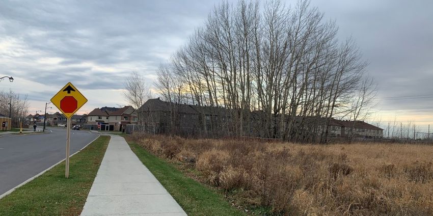
1

1.0
INTRODUCTION
Fotenn Consultants Inc. (“Fotenn”) has been retained by Minto Communities (“Minto”) to prepare a Planning
Rationale in support of a Major Zoning By-law Amendment application to support the Avalon West Stage 2E
residential development on the lands legally known as Part of Lot ‘2’, Concession 11, Geographic Township of
Cumberland and municipally known as 353 Gerry Lalonde in Ottawa’s eastern community of Orléans (“subject
lands”).

The following studies and plans have been prepared in support of the Major Zoning By-law Amendment
application:

    /   Topographical Plan of Survey, prepared by Stantec, dated March 3, 2021;
    /   Concept Plan, prepared by Fotenn, March 2,, 2021;
    /   Building Elevations and Block Plans prepared for Minto;
    /   Functional Servicing Report, prepared by Atrel Engineering, dated March 2021 including:
        o Macro Grading Plan
        o Macro Erosion and Sediment Control Plan
        o Boundary Conditions Plan
        o Watermain Size and Alignment
        o Macro Sanitary Drainage Plan
        o Macro Storm Drainage Area Plan
        o Composite Utility Plan
        o Road Cross Sections
    /   Geotechnical Investigation, prepared by Paterson Group, dated January 7, 2021;
    /   Phase 1 Environmental Site Assessment, prepared by Paterson Group, dated January 19, 2021;
    /   Transportation Impact Assessment- Step 1 (Screening), Step 2 (Scoping), Step 3 (Forecasting), and
        Step 4 (full TIA) prepared by Novatech, dated February and March 2021;
    /   Phase 1 Noise Control Feasibility Study, prepared by Atrel Engineering, dated March 2021; and
    /   Tree Conservation Report and Environmental Impact Statement prepared by Muncaster Environmental
        Planning, dated January 6, 2021.

March 2021
                                                              353 Gerry Lalonde Drive
                                                              Planning Rationale/Design Brief/IERS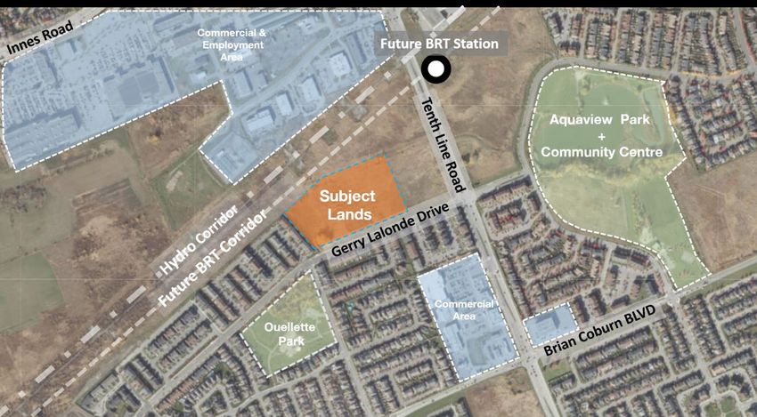
2

1.1       Application History
The broader area originally received Draft Plan of Subdivision Approval in 2014 and over time, applications
were made to extend draft approval for the undeveloped portions of the subdivision, including the subject lands
(City File Numbers D07-16-09-0018, D07-16-17-0020, D07-16-20-0024, and D07-16-06-0009). Draft plan
approval was most recently extended to October 2, 2023.

1.2       Application Summary
A residential subdivision comprised of 192 townhouse units, including 100 townhouses and 92 back-to-back
townhouses, and the creation of multiple local streets is proposed for the subject lands. In order to permit the
development as planned, a Major Zoning By-law Amendment application is required. The previous Plan of
Subdivision application established three development blocks (Blocks 16, 17 and 18), an access block (Block
19) and a municipal street (Street No. 27) on the subject lands (Figure 1). The current Zoning By-law
Amendment application is required to now rezone the subject lands to permit the proposed townhouse
dwellings. More specifically, the following zoning is proposed:

      /   Residential Third Density Zone, Subzone YY, with Exceptions (R3YY[XXXX]) to permit the
          development of 192 traditional townhouses and back-to-back townhouses. The proposed Exception
          would apply provisions that are unique to Minto’s products.

Figure 1 Draft Plan of Subdivision Application for Subject Lands and Surrounding Area (2014).

March 2021                                                                           353 Gerry Lalonde Drive
                                                                                     Planning Rationale/Design Brief/IERS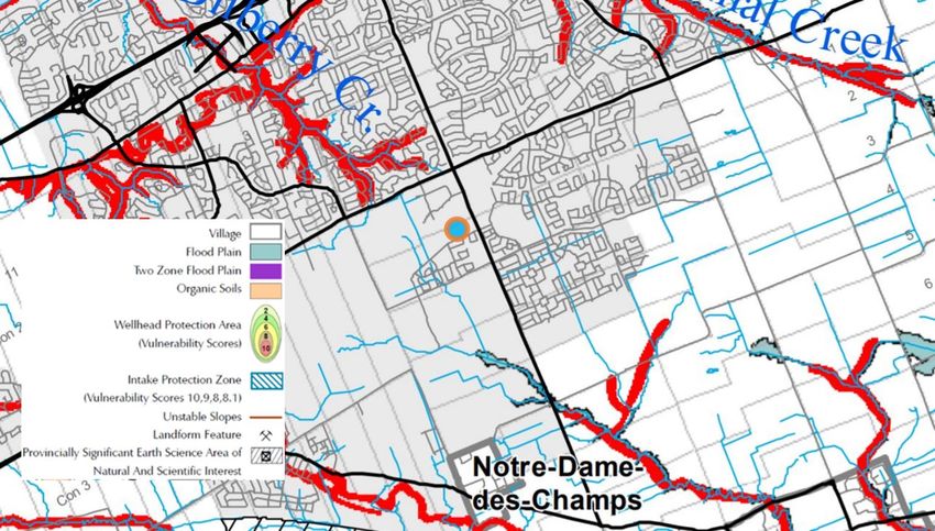
3
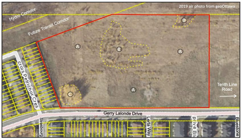
1.3 Subject Lands
The subject lands consist of an area of 4.7 hectares with approximately 270 metres of frontage along the
southern boundary of the property abutting Gerry Lalonde Drive (Figure 2). The northern boundary of the
property abuts the future Cumberland Transitway (planned Bus Rapid Transit (BRT) corridor), with the closest
station proposed to the northeast at Tenth Line Road. Further north is a 91-metre wide hydro corridor managed
by Hydro One Networks Inc. (HONI) via an easement over privately-owned lands, within which a municipal
Multi-Use Pathway (MUP) is planned. To the northeast of the subject lands is a private parcel that is currently
undeveloped and zoned Development Reserve (DR).
The subject lands are irregularly shaped, with predominantly flat topography and a small grove of trees located
in the southeast corner with no other discernable vegetation at this time. The subject lands are currently
undeveloped and have been historically used for agricultural purposes.
Figure 2 Site Context Map.
1.4 Area Context
The subject lands are situated in the Portabello South and Avalon West neighbourhoods in Orléans (Ward 19).
The area consists of established and expanding residential subdivisions to the south, east and west, with a
range of community amenities and services typical of growing suburban neighbourhoods including parks,
schools, and recreation facilities. Further, in close proximity to the subject lands are commercial and retail hubs
along Tenth Line Road and Innes Road as well as employment lands along Vanguard Drive, which is planned
to be extended further west through currently undeveloped employment lands. The planned and existing Minto
Avalon Community is a 750-acre neighbourhood comprising of over 3,500 homes including a mix of detached,
semi-detached, and townhome units.
The following land uses are located in the area surrounding the subject lands:
NORTH: Immediately northeast of the subject lands are undeveloped private lands with frontage along Tenth
Line Road. Also immediately north are the planned Cumberland Transitway and Hydro Corridor with planned
March 2021 353 Gerry Lalonde Drive
Planning Rationale/Design Brief/IERS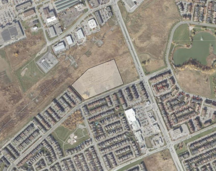
4

Multi-Use Pathway. A future BRT station is proposed for future placement at Tenth Line Road within 200-500
metres of the subject lands.

Further north is an established commercial area along Tenth Line Road and Innes Road (an Arterial
Mainstreet). This area contains full-service retail food stores, personal service shops, and other convenience
amenities. Light industrial employment lands are located along Vanguard Drive.

To the north, Innes Road and Tenth Line Road offer transportation connections to the broader community.
More specifically, Tenth Line Road provides access to Highway 174 approximately 3.6 kilometres to the north
while Innes Road provides access to Highway 417 approximately 10.7 kilometres to the west.

EAST: Immediately east of the subject lands is a currently undeveloped parcel of land with frontage on both
Gerry Lalonde Drive and Tenth Line Road. This property is subject to an ongoing planning application process
to permit a planned unit development (PUD) consisting of four (4) mid-rise buildings between five and six
stories in height. Three buildings will consist entirely of residential uses, while one building will have primarily
residential uses with commercial uses on the ground floor along Tenth Line Road. The development is planned
to provide 251 apartment units at full build-out.

Further east are established and emerging residential communities including earlier and ongoing phases of
Minto’s Avalon community (including Avalon Aquaview on the east side of Tenth Line, where back-to-back and
standard townhouses are currently under development) as well as communities by other developers. This area
is well served by municipal parks and schools. The Aquaview Pond stormwater management area, located
approximately 300 metres east of the subject lands, also offers recreational opportunities by way of a Multi-Use
Pathway that runs along the perimeter of the pond and connects to pathways in Aquaview Park to the south.
Approximately 1.5 kilometres to the southeast of the subject lands is the Francis Dupuis Recreation Centre,
which offers a swimming pool and gym, amongst other facilities. Finally, the Millennium District Park, which
offers sports fields and an extensive children’s play area comprised of play structures and a splash pad, is
located approximately 3 kilometres to the east of the subject lands.

SOUTH AND WEST: Immediately west of the subject lands is a recently constructed residential development
consisting of two- and three- storey townhouse dwellings, which includes Stage 2 of the Minto Avalon West
community as well as Tamarack’s Chaperal Private. Further east, with frontage along Mer Bleue Road and
Brian Coburn Boulevard, is the Orléans Health Hub, a new multi-disciplinary health and wellness facility
developed by the Montfort hospital, which is to be completed in the Fall of 2021.

South and west of the subject lands are established and emerging residential communities located within the
Mer Bleue Expansion Area Community Design Plan (CDP) and the Phase 1, 2 and 3 Area CDPs for the East
Urban Community (EUC). These communities provide for numerous community amenities including parks
schools.

A new commercial area comprised of such uses as a retail food store, retail stores, restaurants, and a bank is
located less than 200 metres south of the subject lands, with frontage along Tenth Line Road.

Schools
The Mer Bleue CDP indicates that there are over 30 schools located within the influence of the CDP area. The
subject lands are located within an established neighbourhood which is served by the following existing
schools:
    ⁄   Dunning-Foubert Elementary School;
    ⁄   Summerside Public School;
    ⁄   Notre Place Catholic Elementary School;
    ⁄   Alain Fortin Cathlic Elementary School;
    ⁄   St. Dominc Catholic School;
    ⁄   Notre Dame De Champs Public School; and
    ⁄   St Theresa Catholic School.

March 2021                                                        353 Gerry Lalonde Drive
                                                                  Planning Rationale/Design Brief/IERS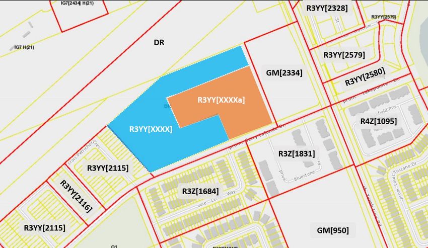
5
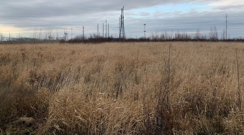
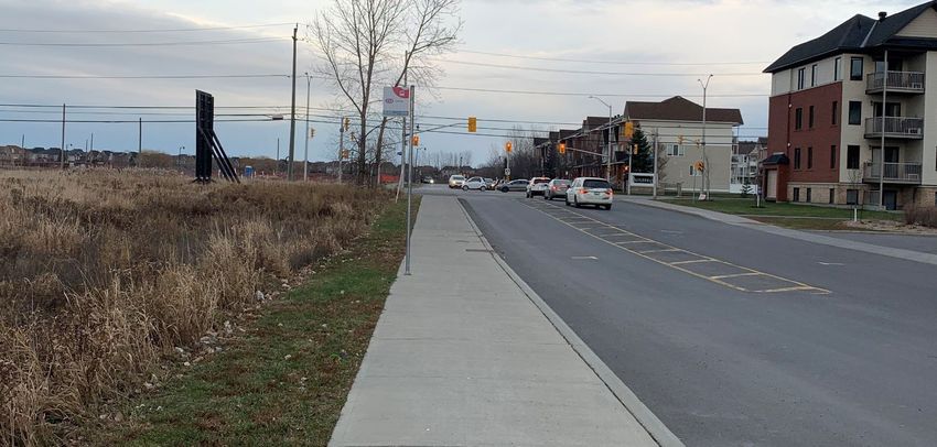
1.4.1 Photos of Subject Lands
The following photos illustrate the existing condition of the subject lands as well as the surrounding properties.
Figure 3 View of southwest corner of the subject lands (including the tree stand), looking west along Gerry Lalonde Drive.
Figure 4 View south from the subject lands towards the low-rise residential development on Lerta Way.
March 2021 353 Gerry Lalonde Drive
Planning Rationale/Design Brief/IERS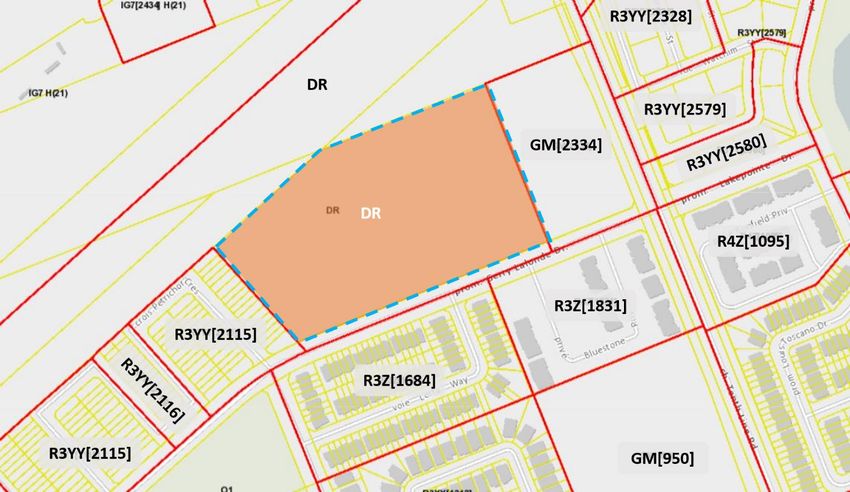
6

Figure 5 View north across the subject lands with hydro corridor in background.

Figure 6 View east from subject lands towards the intersection of Gerry Lalonde Drive and Tenth Line Road.

March 2021                                                                         353 Gerry Lalonde Drive
                                                                                   Planning Rationale/Design Brief/IERS
7
Figure 7 Looking south towards existing higher-density residential development along Gerry Lalonde Drive with retail/commercial development in
the background (fronting onto Tenth Line Road).
1.5 Road, Cycling and Transit Network
1.5.1 Cycling Network
The subject lands are well served by existing and planed cycling infrastructure. The subject lands are located
within proximity to a cross-town bikeway (Innes Road), cycling spine routes (Innes Road and Tenth Line Road),
and a future Multi-Use Pathway (to be located within the Hydro Corridor, which connects to the greater cycling
network) as identified on Schedule C – Primary Urban Cycling Network of the Official Plan (Figure 8). The
proposed development will link to the Transitway via “Street 5” on the Concept Plan. Mer Bleue Road, located
approximately 1 kilometre to the west is also indicated as a Spine Route on Schedule C of the Official Plan.
Figure 8: Excerpt from Schedule C- Primary Urban Cycling Network of the Official Plan.
March 2021 353 Gerry Lalonde Drive
Planning Rationale/Design Brief/IERS8
1.5.2 Road Network
As per Schedule E- Urban Road Network of the Official Plan, the subject lands are located in proximity to an
existing arterial road (Tenth Line Road) (Figure 9). Gerry Lalonde Drive is categorized as a Collector road,
which connects to the greater street grid through Tenth Line Road to the east and Briand Coburn Boulevard
(Arterial roadway) to the south. Innes Road to the north is an important arterial road in the transportation
network for Orléans. This four-lane arterial provides an east-west connection between Trim Road
approximately 2.8 kilometres to the east and Highway 417 approximately 10 kilometres to the west.
Figure 9: Schedule E - Urban Road Network of the Official Plan.
March 2021 353 Gerry Lalonde Drive
Planning Rationale/Design Brief/IERS9
1.5.3 Greater Transit Network
The subject lands are located adjacent (200 to 500 metres) to a future BRT Station (at Tenth Line Road) along
the planned Cumberland Transitway BRT route which is shown in dark blue on Schedule D- Rapid Transit
Network of the Official Plan (Figure 10). The timing of the BRT is currently post-2036. The subject lands are
currently served by OC Transpo bus route 234, which runs along Gerry Lalonde, and Tenth Line with Service to
Place D’Orléans and from there the greater transit network.
Figure 10: Excerpt of Schedule D - Rapid Transit Network of the Official Plan.
March 2021 353 Gerry Lalonde Drive
Planning Rationale/Design Brief/IERS10
2.0
PROPOSED DEVELOPMENT & DESIGN BRIEF
2.1.1 Proposal Overview and Design Brief
Minto is proposing to develop the subject lands with a residential subdivision comprised of 192 ground-oriented
townhouse units, including 100 back-to-back (avenue) townhouse units and 92 standard (executive) townhouse
units (Figure 11). The units are organized in 29 blocks along five new local streets, save for ten (10) townhouse
units that will front onto existing Gerry Lalonde Drive. The proposed streets local streets of the proposed
development of which all are be designed to the city’s standards for local streets and eventually conveyed to
the City.
Figure 11 Concept Plan.
The proposed townhome units will vary in size from 105 m2 to 210 m2 approximately in floor area, depending on
the model, and range from are 2 to 4-bedroom units. The typical townhome lot width is approximately 6 metres,
with the lot depths ranging from 26 to 31 metres. With a net area of 2.9 hectares, a density of 65.29 units/net
hectare is proposed.
The executive townhouse units are two storeys in height and contain three to four bedrooms while the back-to-
back townhouses are three full storeys in height, with each unit occupying all three storeys and having either
two or three bedrooms depending on the location of the unit within the block.
The proposed building orientation for the executive and back-to-back townhomes provide for frontage along the
internal street network as well as along Gerry Lalonde Drive in the form of front facing and corner units with
prominent front entrances, ample glazing, and high-quality materiality that wraps around the building form to
ensure a consistent and complementary design approach. The proposed building typologies will have peaked
roofs, articulated front facades, and active entrances, reflecting architectural features in the broader Avalon
community.
March 2021 353 Gerry Lalonde Drive
Planning Rationale/Design Brief/IERS11
Figure 12 3D Concept Rendering looking south.
Vehicular access to the development will be provided through two access points via Gerry Lalonde Drive at the
west and east ends of the subject lands (via proposed “Street 1” and “Street 5”). Pedestrian access is also
provided via “Street 1” and “Street 5” through the provision of a municipal sidewalk along one side of the street.
Further, a mid-block pathway is proposed from Gerry Lalonde Drive to “Street 4A”; a single loaded window
street with a width of 14 metres. To the northwest corner of the subject site, “Street 5” which continues from
Gerry Lalonde, provides for future access to lands to the north (currently terminates at the boundary of the
subject lands). As indicated in the submitted Concept Plan, municipal street trees are proposed to frame the
local street network throughout the proposed development.
Sidewalks are proposed on one side of “Street 1” and “Street 5”, providing convenient and safe pedestrian
routes within the development and connecting to the pedestrian network in the greater community along Gerry
Lalonde Drive. The proposed local streets will also contain street trees lining each side of the ROW. Parking is
provided in the form of paired driveways leading to individual private garages where the required parking space
is located.
The following table identifies the proposed land uses and the associated block numbers and areas:
Table 1. Proposed Land Uses
Project Summary
Land Use Units Blocks Net Area
Townhouses 100 1-21 2.05 ha
Back-to-Back Townhouses 92 22-29 0.86 ha
Streets 1-5 1.8 ha
Total Area 4.71 ha
Total Net Density 65.98 unit/net ha
March 2021 353 Gerry Lalonde Drive
Planning Rationale/Design Brief/IERS12
2.1.2 Roads and Pathways
As previously mentioned, the proposed development will be accessed via two local streets (Street 1 and Street
5) via Gerry Lalonde Drive; an existing Collector street. As Local Streets, the proposed right-of-way (ROW)
widths is 18 metres for all streets, save for the single-loaded portion of Street 5 and 4B in the northeast corner
of the subject lands, which will have ROW widths of 14.75 metres and 14.0 metres respectively. Pedestrian and
bicycle access is provided via “Street 1” and “5” as well as a mid-block connection pathway with access to
Street 4B; a single-loaded window street with a width of 14 metres.
2.1.3 Site Servicing
The site will be on full urban services of which the details are to be determined at detailed subdivision design
stage with stormwater directed to an existing stormwater management facility about one kilometre south of the
site (N5 Pond).
March 2021 353 Gerry Lalonde Drive
Planning Rationale/Design Brief/IERS13
3.0
POLICY FRAMEWORK
3.1 Provincial Policy Statement (2020)
The Provincial Policy Statement (PPS) was issued under Section 3 of the Planning Act and came into effect
May 1, 2020, replacing the PPS issued April 30, 2014. The PPS provides policy direction on matters of
provincial interest related to land use planning and development. As a key part of Ontario’s policy-led planning
system, the Provincial Policy Statement sets the policy foundation for regulating the development and use of
land.
The PPS provides for appropriate development while protecting resources of provincial interest, public health
and safety, and the quality of the natural and built environment. The PPS supports improved land use planning
and management, which contributes to a more effective and efficient land use planning system. The policies of
the PPS that are of relevance to the proposed development are analyzed below.
Efficient and resilient development and land use patterns
/ Promotes efficient development and land use patterns which sustain the financial well-being of the
Province and municipalities over the long term;
/ Accommodates an appropriate range and mix of residential, recreational and open space uses to meet
long-term needs;
/ Promotes cost-effective development standards to minimize land consumption and servicing costs; and
/ Ensures that necessary infrastructure and public service facilities are or will be available to meet
current and projected needs.
Settlement Areas
/ Land use patterns within Settlement Areas shall be based on densities and a mix of land uses which:
/ a) Efficiently use land and resources; and
/ b) Are appropriate for, and efficiently use, infrastructure and public service facilities which are
planned or available, and avoid the need for their unjustified and/or uneconomical expansion.
/ New development taking place in designated growth areas should occur adjacent to the existing built-
up area and shall have a compact form, mix of uses and densities that allow for the efficient use of
land, infrastructure and public service facilities.
Housing
/ Maintains ability to accommodate residential growth within a Settlement Area in accordance with the
PPS;
/ Provides for an appropriate range of housing types and densities; and
/ Directs the development of new housing towards locations where appropriate levels of infrastructure
and public service facilities will be available to support current needs.
Public Spaces, Recreation, Parks, Trails and Open Space
/ Plans public streets, spaces and facilities to be safe, meet the needs of pedestrians, foster social
interaction, facilitate active transportation and community connectivity; and
/ Plans and provides for a full range and equitable distribution of publicly accessible built and natural
settings for recreation, including facilities, parklands, public spaces, open space areas, trails and
linkages, and, where practical, water-based resources.
The proposed development is consistent with the above noted policies of the PPS. More specifically,
the proposal seeks to develop an area that is located within the City of Ottawa’s Urban Area,
immediately adjacent to an existing built-up area and existing and future rapid and active transportation
options, which allows for the logical and efficient extension of existing services and roads. The
March 2021 353 Gerry Lalonde Drive
Planning Rationale/Design Brief/IERS14
proposal provides for a range of housing options supported by and surrounding established
community.
Policy 1.1.5.5 the PPS states that development shall be appropriate to the infrastructure which is planned or
available, and avoid the need for the unjustified and/or uneconomical expansion of this infrastructure. The
proposal is appropriate for the infrastructure available.
The proposed development will contribute to an efficient development pattern, as planned through the
Mer Bleue CDP, and will facilitate the development of higher density housing in proximity to a planned
BRT station. The requested Zoning By-law Amendment application is consistent with the PPS.
3.2 City of Ottawa Official Plan (2003, as amended)
3.2.1 Section 2.2.2 – Managing Intensification within the Urban Area
The Official Plan (OP) supports intensification within the Urban Area, including but not limited to:
“The development of vacant or underutilized lots within previously developed areas, being defined as adjacent
areas that were developed four or more years prior to new intensification.”
The subject lands are not located in a target intensification area, which includes Central Area, Mixed Use
Centres, Mainstreets, and Town Centres. However, policy 22 in Section 2.2.2 states that the City will support
intensification outside of target intensification areas, including in the General Urban Area, in particular where it
will enhance and complement its desirable characteristics and long-term renewal.
Policy 10 in Section 2.2.2 acknowledges that intensification may occur in a variety of built forms, from low-rise
to high-rise, provided urban design and compatibility objectives are met and notes that low-rise intensification
will be the predominant form of intensification in the General Urban Area designation.
The proposed development provides an opportunity to increase the number of residents living within
proximity of existing schools, parks, and transit routes and maximize the use of existing municipal
infrastructure. The additional residents will also serve to support the nearby Arterial Mainstreet (Innes
Road) and the Town Centre in Orléans, contributing to their viability. As previously noted, the proposed
development would have a density of 65.98 unit/net ha. When considered with the planned mid-rise
apartment development to the immediate east, a residential density of 98 units per hectare is expected
to be achieved, exceeding density targets of the OP and CDP.
3.2.2 Section 3.6.1 – General Urban Area Designation
The subject lands are designated “General Urban Area” on Schedule B- Urban Policy Plan of the Official Plan
(Figure 13). The General Urban Area designation permits a wide variety of uses, including a full range and
choice of housing types to meet the needs of all ages, incomes and life circumstances. Townhomes are a
permitted use in the General Urban Area. Generally, uses that have the potential for negative impacts, such as
noise, traffic, or lighting, are directed to locate at the edges of communities.
As noted previously, building heights in the General Urban Area are expected to be predominantly low-rise
(four storeys or less), with taller buildings permitted in select locations, such as fronting on arterial roads and in
proximity to transit or in areas already characterized by taller buildings.
The Official Plan supports intensification within the General Urban Area where it will complement the existing
pattern and scale of development and planned function of the area. In reviewing applications for intensification,
the City will:
/ Assess the compatibility of new development as it relates to existing community character so that it
enhances and builds upon desirable established patterns of built form and open spaces and
March 2021 353 Gerry Lalonde Drive
Planning Rationale/Design Brief/IERS15
/ Consider its contribution to the maintenance and achievement of a balance of housing types and
tenures to provide a full range of housing for a variety of demographic profiles throughout the General
Urban Area.
The proposed development meets the policies of the General Urban Area designation as it fulfills
intensification policies in a manner which is compatible with the existing residential neighbourhood.
More specifically, the proposed low-rise townhomes (2- and 3- storeys) will be compatible with the
existing 2-storey townhomes along in the immediate area along Gerry Lalonde Drive and the greater
Avalon community and the local streets which have access from that roadway.
Figure 13: Excerpt from Schedule B - Urban Policy Plan of the Official Plan
3.2.3 Section 2.5.1 – Urban Design and Compatibility
Section 2.5.1 of the Official Plan contains design objectives that are intended to be applied to new
development. The design objectives of Section 2.5.1 are met by the proposed plan of subdivision in the
following ways:
Enhance the sense of community by creating and maintaining places with their own distinct identity
The proposed subdivision makes more efficient use of an underutilized lot in an existing suburban
neighbourhood. The subdivision will contribute to the sense of community through the provision of new
opportunities for residential growth in close proximity to existing commercial/retail, recreation, and mobility
opportunities. The proposed building typologies will have peaked roofs, articulated front facades, and active
entrances, reflecting architectural features in the larger Avalon community.
Define quality public and private spaces through development
The proposed public spaces, including implementing tree-lined municipal streets, a connection to an future
green corridor with proposed MUP, and pedestrian connections to Gerry Lalonde Drive will serve to connect the
proposed private spaces (townhome lots) to the public realm.
March 2021 353 Gerry Lalonde Drive
Planning Rationale/Design Brief/IERS16
Create places that are safe, accessible and are easy to get to, and move through
The proposed ground-oriented, street-fronting units will contribute to a pleasant pedestrian realm and will also
provide “eyes” on the street, increasing actual and perceived safety. Three vehicular entrances, including two
entrances off Gerry Lalonde Drive and one leading to the lands to the north are proposed. The pathway
provided to the development is aligned with the proposed street network allowing for an accessible route
between existing and proposed units and the components of the overall community network. The proposed
street network expands the existing municipal network of public sidewalks and pathways to promote pedestrian
safety, convenience and connectivity.
Ensure that new development respects the character of existing areas
The proposed built form (townhomes) is compatible with the existing townhomes and detached homes found in
the immediately surrounding area. Further, the proposed density reflects the location of the subject lands within
this community and in close proximity to future rapid transit while the low-rise built form will be compatible with
lower-density residential uses to the south and west of the subject lands, which includes a mix of detached,
townhouse, and back-to-back townhouse dwellings.
Consider adaptability and diversity by creating places that can adapt and evolve easily over time and
that are characterized by variety and choice
The proposed infill development is representative of evolution that can occur over time in communities. The
townhouse units will allow existing residents within the broader area to continue to live within the community as
they move through their lifecycle. A future connection to the north is considered with the orientation of “Street
5” within the overall local street network.
Understand and respect natural processes and features in development design
Given the previous agricultural use, the subject lands have limited natural features. As outlined in the Tree
Conservation Report (TCR) and Environmental Impact Statement (EIS) prepared by Muncaster Environmental
Planning Inc. (January 6, 2021), there are no significant natural heritage areas (Significant Woodlands, Valley
Lands or Wetlands, no watercourses other than roadside ditches, ANSIs, Urban Natural Areas) or areas
indicated as having potential natural heritage significance located within 120 metres of the subject lands. To
assist in mitigating a minor amount of tree removal, plantings of native trees and shrubs are recommended
where soil conditions permit. The TCR/EIS report concludes that the proposed development will not have a
significant impact on the environmental features and functions of the local landscape. The Geotechnical Report
prepared by Paterson Group (January 7, 2021) indicates that Atterberg testing confirms the need for a 4.5
metre setback between tress and foundations, which is proposed in the subdivision.
Maximize energy-efficiency and promote sustainable design to reduce the resource consumption,
energy use, and carbon footprint of the built environment.
The proposed subdivision is considered infill development, which will add more residents within an existing
urban serviced area. More specifically, the proposed density (65.29 units/net hectare) well exceeds the
minimum density of 34 units/net hectare that is required in the Official Plan for new Greenfield development
outside of the Greenbelt and the proposed minimum density of 36 units/net hectare in the draft Official Plan
(November 2020). Moreover, when considered with the surrounding planned context, the proposed overall
density of 98 units per hectare also exceeds the minimum density requirements of the CDP. As such, the
proposed subdivision will result in more efficient use of existing urban land and existing infrastructure, such as
pipes, roads, transit, schools, and parkland.
Importantly, the proposal is located in proximity to future BRT station along the planned Cumberland
Transitway as well as active transportation options (MUPs through the hydro corridor) and is within walking
distance to full-service retail/commercial areas, ensuring residents will have a full-range of convenient and safe
mobility options available.
3.2.4 Section 4.11 – Urban Design and Compatibility
Section 4.11 addresses issues of urban design and compatibility. The following policies are applicable to the
subject lands and have been evaluated with respect to the proposed subdivision.
March 2021 353 Gerry Lalonde Drive
Planning Rationale/Design Brief/IERS17
Table 2: Urban Design and Compatibility Criteria of Section 4.11 of the Official Plan
Policies Proposed Subdivision
Views The Official Plan does not designate any protected views in proximity to the subject lands.
Given the low-rise nature of the proposed subdivision, the subdivision will not impact the
existing skyline.
Building All units are proposed to front directly onto an existing or proposed municipal street, which
Design maintains the character of the existing streetscape in the area and along Gerry Lalonde Drive.
The proposed townhome elevations exhibit a gable roof, similar to the existing townhomes in
the immediate area. The elevations proposed by Minto improve upon the existing streetscape
by accentuating the front entrances. More specifically, the prominent front entrances are
distinguishable from the garages, making the front entrances the prominent features on the
front facades. The proposed cladding materials are siding, masonry, and wood shingles which
are in keeping with the design aesthetic of the immediate area.
Massing and At two and three storeys, the proposed height, design, and massing of the executive and
Scale back-to-back townhomes indicate a considerate approach that respects and complements the
existing built form and community character in this neighbourhood. The development is
proposed to be zoned for a maximum height of 12 metres, which is compatible with the zoning
of the existing low-rise neighbourhoods to the immediate south and east (11 &12 metres).
The proposed lot width (6 metres) is similar to the lot widths of the existing zoning of the
townhomes to the immediate south, west, and east of the subject lands (6 metres).
The proposed front yard setback of 3 metres does not vary significantly from the zoning to the
immediate south and east (4, 5 and 6 metres).
Given that the proposed development will consist only of low-rise dwellings, no concerns
related to massing and scale, such as privacy, overlook, or shadowing, are expected.
Outdoor Similar to the existing townhouses in the area, the proposed executive (standard) townhomes
Amenity will have a rear yard. A minimum rear yard setback of 6 metres is proposed, which is
Areas appropriate and compatible with the zoning of the existing townhomes in the area (6 and 6.5
metres). The back-to-back townhomes will benefit from ample street-tree planting, private
balconies, and are within walking distance of multiple municipal parks, such as Ouellette Park
to the southwest and Aquaview Park to the southeast.
As outlined in Table 2 above, the proposed development is compatible with the existing
neighbourhood.
March 2021 353 Gerry Lalonde Drive
Planning Rationale/Design Brief/IERS18
Figure 14. Example of Minto Back-to-Back Townhouse elevations (3-storeys).
Figure 15 Example of Minto Back-to-Back Corner Unit.
March 2021 353 Gerry Lalonde Drive
Planning Rationale/Design Brief/IERS19
Figure 16: Example of Minto Townhouse front elevation (2-storeys).
Figure 17 Example of Minto Corner Townhouse elevation.
The proposal ensures that the buildings reflect the existing and planned neighbourhood pattern in
terms of building height, massing, and the location of primary entrances/front facing glazing, as well as
front, rear, and side yard setbacks. Further, the design of the residential buildings uses high-quality
materials, patterns and colours the reflects and complements the existing character of the community.
March 2021 353 Gerry Lalonde Drive
Planning Rationale/Design Brief/IERS20
3.2.5 Section 4.3 – Walking, Cycling, Transit, Roads and Parking Lots
Policies addressing connectivity through walking, cycling, transit and roads are detailed in Section 4.3 of the
Official Plan. These policies address a number of aspects including active transportation, parking structures,
sidewalks, and cycling facilities, among others. Policies applicable to the subject lands and the proposed
development include the following:
/ The City will require that new plans of subdivision and other developments include adequately spaced
inter-block/street cycling and pedestrian connections to facilitate travel by active transportation.
Municipal sidewalks are proposed along one side of “Street 1” and “Street 5”, providing a pedestrian
network from Gerry Lalonde Drive, through the subdivision, to the lands to the north, where the
Transitway is planned. Further, access to the sidewalks along Gerry Lalonde Drive is accommodated
through a mid-block connection from the proposed window street (“Street 4B”). The proposed local
street network and consideration for future connections promotes enhanced pedestrian and cyclist
safety, convenience and connectivity.
3.3 Mer Bleue Community Design Plan (2005)
The Mer Bleue Community Design Plan (CDP) provides guidance for the future development of the Mer Bleue
area in accordance with the requirements of the Official Plan. The area subject to the Mer Bleue CDP is bound
to the north by the southern boundary of the hydro corridor, to the west by Mer Bleue Road, to the east by
Tenth Line Road and south by the Mer Bleue Expansion Area CDP (2017) lands.
3.3.1 Guiding Principles
Section 4.1 of the CDP establishes a set of Guiding Principles that form the basis for the Community Design
Plan:
⁄ Achieve a sustainable mix of uses – a place where people can live, work and play, which contribute to
the diversity and vibrancy of the East Urban Community.
⁄ Create a compact mixed-use urban form making efficient use of land resources and existing and
planned infrastructure.
⁄ Support and reinforce high quality transit service by providing transit oriented development and efficient
links to the two transit stations at Mer Bleue and 10th Line Roads.
⁄ Facilitate walking, cycling and recreation by creating an integrated pedestrian trail and sidewalk
network throughout the community, which will link to adjacent communities.
⁄ Provide an opportunity for a mix of residential housing types, with a maximum of 60% singles and
semis, and a minimum of 10% apartments, and the remainder as multiple dwellings other than
apartments. The housing mix will also include a certain number of affordable housing units, per the
requirements of the Official Plan.
⁄ Aim for an overall residential density of 31 units per net hectare in the area designated in the Official
Plan as ‘General Urban Area’.
⁄ Development will have regard to potential environmental considerations and constraints such as flood
plains and soils.
⁄ Ensure that future development minimizes impacts on surrounding natural heritage features.
⁄ Provide opportunities for centrally located community facilities.
⁄ Provide a safe and efficient road network in accordance with the principles of transportation demand
management and approved City standards.
3.3.2 Land Use Designation
The subject lands are designated “Mixed Use Area” on the CDP Land Use Plan (Figure 18). As per Section
5.1.2, the intent of the Mixed Use designation is to accommodate a wide range of office, institutional, and
convenience retail uses. High Density Residential uses also permitted, including low- and mid-rise apartment
buildings, with an ‘apartment’ defined as “a non-ground-oriented residential building having a density of 80 units
per net hectare or more”. Development within the Mixed Use area should focus on integrating and directing
built form to the proposed transit stations at Mer Bleue and Tenth Line Roads to increase walkability and
March 2021 353 Gerry Lalonde Drive
Planning Rationale/Design Brief/IERS21
access to transit. Section 5.1.5 of the CDP notes that safe and easy access to the hydro corridor should be
provided as the Mixed Use areas at Mer Bleue and Tenth Line develop.
Section 7.1 of the CDP states:
“The land use designations identified in the Land Use Plan are intended to show general areas. The
boundaries of the designations are flexible and may vary without amendment to the Plan”.
Further, Section 7.4 notes that when substantive changes are proposed, they will be subject to approval by
Planning Committee and Council. The CDP provides the following examples of substantive changes:
/ The number of high density residential blocks;
/ The location of arterial and collector roads and protected infrastructure corridors;
/ The removal of park blocks, or;
/ Changes that could jeopardize the area’s ability to achieve the Official Plan’s strategic directions.
While they do not meet the definition of an “apartment” in either the CDP or Comprehensive Zoning By-
law (2008-250), back-to-back townhouses are similar to low-rise apartment buildings in terms of number
of bedrooms, height (< 4 storeys) and the use of balconies for outdoor private amenity space. Back-to-
back townhouses vary from apartment units in that they have a private driveway leading to a garage
and are freehold as opposed to rental or condominium.
Back-to-back townhouses were not a common built form in 2005 and therefore are not contemplated in
the CDP. Providing back-to-back units would expand the range of built form available to potential
residents, therefore expanding choice, which is one of the primary policies of the applicable General
Urban Area designation in the Official Plan. The proposed back-to-back townhouses also provide a
transition from the six-storey apartment buildings that are proposed to the immediate east of the
subject lands, abutting Tenth Line Road. The standard 2-storey townhouses proposed at the western
edge of the subject lands provide a further transition down to the existing residential neighbourhood to
the west and south, where standard 2-storey townhouses are located.
If the proposed development is deemed to be substantive change to the CDP, it is understood that the
CDP could be amended through the Staff Report for the proposed Zoning By-law Amendment, which is
subject to Planning Committee and Council approval.
Figure 18 Mer-Bleue CDP Land Use Plan.
March 2021 353 Gerry Lalonde Drive
Planning Rationale/Design Brief/IERS22
3.3.3 Density and Unit Type
The CDP Demonstration Plan (Figure 19) illustrates one detailed way to develop the Mer Bleue area in keeping
with the policies and guidelines of the CDP. Table 3 of CDP outlines the assumptions that were applied to the
Demonstration Plan to generate job and residential unit estimates for each designation. In addition to the
subject lands, the lands located to the east and south (abutting Tenth Line Road), and lands northeast of the
intersection of Mer Bleue Road and Brian Coburn Boulevard, are designated Mixed Use in the CDP. It was
assumed that 75% of the land in the Mixed Use area would be employment uses while the remaining 25%
would be developed with residential uses at a density of 80 units per net hectare, which resulted in a prediction
of 300 high density residential units and 3,000 jobs.
Section 5.1.2.1 of the CDP notes that the lands designated Mixed Use northeast of the intersection of Mer
Bleue Road and Brian Coburn Boulevard are intended to generate the majority of jobs in the Mer Bleue Area;
The Montfort Hospital is currently developing the Orléans Health Hub on these lands. While the Mixed Use
area at Gerry Lalonde and Tenth Line Road (where the subject lands are located) will be available to
accommodate a mix of residential use with local and supportive commercial opportunities.
Figure 19 Mer-Bleue CDP Demonstration Plan.
With 192 units located on 2.91 net hectares of land, the proposed development achieves a density of
65.29 units per hectares, which is nearly double the overall residential density target of 31 units per
hectare as stated in the guiding principles section of the CDP. However, the net density of the proposed
development does not achieve the higher 80-units per hectare estimate that was applied to the Mixed
Use designation when the CDP was prepared. With that being said, when calculating overall density, it
is important to consider the broader context. In that sense, including the proposed mid-rise
development to the immediate east of the subject provides a more accurate indication of residential
March 2021 353 Gerry Lalonde Drive
Planning Rationale/Design Brief/IERS23
density for this area. The development at 2168 Tenth Line Road proposes 251 apartment units on 1.61
net hectares in land. When combined with the unit total of Minto’s proposal for the subject lands, the
overall residential density is calculated at 98 units per hectare, which is well above the minimum
density applied in the CDP. Further, the total of 443 residential units in low and mid-rise built form is
considerably higher than the 329 units generated in Table 2 of the Mer Bleue CDP.
3.3.4 Road Standards
The following guidelines pertain to the proposed development:
⁄ Guideline 5.2.2: Local Roads will have an 18 metres right-of-way (or the approved standard at the time
of subdivision).
⁄ Guideline 5.2.3: Local roads will provide a sidewalk on one side. In addition, mid-block connections
will be provided as appropriate and in accordance with City Policy throughout the community to further
support the connectivity and safety of the pedestrian network.
⁄ Guideline 6.2.2.1: Neighbourhoods should not turn their backs on major transportation routes, such as
the Blackburn Hamlet Bypass. Single-loaded roads along major transportation and other design
solutions are encouraged.
⁄ Guideline 6.2.2.2: Buildings will be designed to address major transportation routes such as arterial
and collector roads, by fronting onto the street to enhance streetscape.
⁄ Guideline 6.2.3: Regarding Streets states that the Official Plan directs that new communities should be
designed using a modified grid road pattern in order to:
• Maximize the number of access and egress points;
• Increase permeability of the network;
• Increase pedestrian and transit accessibility;
• Enhance way-finding and personal navigation.
⁄ Guideline 6.2.3.17: If appropriate, local roads will have a sidewalk on at least one side with a minimum
width of 1.8 metres. Sidewalks are not required for single-loaded roads.
⁄ Guideline 6.2.3.18: Single-loaded roads should be used in key areas to minimize the use of sound
barriers (e.g. along the Blackburn Hamlet Bypass), rear lotted streets and provide views into
neighbourhoods.
⁄ Guideline 6.2.3.19 Single-loaded roads may have reduced rights-of-ways of 14.5 metres if approved as
a standard by the City at the time of subdivision and when the sidewalk function is accommodated on
the abutting right-of-way of the collector or arterial road.
The proposed development will consist of a series of local streets with a proposed right-of-way (ROW)
width internally of 18 metres, save for the single-loaded portion of “Street 5” and “Street 4B” in the
northeast corner of the subject lands, which will have ROW widths of 14.75 metres and 14.0 metres
respectively. A proposed sidewalk will run on one side of “Street 1” and “Street 5”. Pedestrian and
bicycle access is provided via “Streets 1” and “Street 5” as well as a mid-block connection pathway to
the western portion of the site with access to “Street 4A”; a single-loaded window street with a width of
14 metres. Where possible, the residential buildings have been designed and positioned to frame and
animate Gerry Lalonde Drive and the local street network with appropriate setbacks, prominent
entrances, and ample glazing on the street-facing façade.
3.3.5 Design Guidelines
Section 6 of the CDP contains a set of design guidelines, which read together are the urban design language
for the future development of the Mer Bleue area. The plan states that all development applications for lands
within the CDP area should have regard to these guidelines.
3.3.6 Mixed Use Areas Design Guidelines:
The Mixed Use areas are planned at the future transit stations at Mer Bleue and Tenth Line Roads. These
areas are intended to provide a vibrant and diversified location for jobs, high density residential and service
March 2021 353 Gerry Lalonde Drive
Planning Rationale/Design Brief/IERS24
commercial oriented to the future transit infrastructure. A mix of residential and commercial uses is encouraged
to create a lively, urban feel to the area. Development should reinforce a high-quality urban identity, distinct
from conventional suburban development through the use of enhanced architecture and landscape design. Site
planning, built form, and landscaping should be coordinated within the mixed-use area to create a vibrant,
visually attractive meeting place in the community. Surface parking will be limited and preferably located
adjacent to the transit corridor and away from the centre of the Mixed Use Areas.
Relevant Guidelines Include:
⁄ Guideline 6.2.7.2: Ensure that corner buildings that ‘turn the corner’ have articulated façades on both
streets.
The proposed corner units carry the materiality and design aesthetic around the corner to
provide for a consistent and high-quality design approach for all public facing facades. The
corner unit design includes prominent front entry features for those units fronting the public
realm.
⁄ Guideline 6.2.7.5 Complementary architectural treatment of buildings within the Mixed Use areas, such
as finish/colour/materials should be encouraged.
The proposed residential buildings will be designed to respect and complement the existing
built-form, massing, and design of those existing within the community currently. The infill
development is designed in a manner that contributes to the quality of the streetscape (exiting
and planned) and at two and three-storeys appropriately considers the impacts of scale and
mass on the adjacent surrounding homes.
⁄ Guideline 6.2.7.6: Building heights will be a minimum of two functional stories. Building heights of five
to seven stories are encouraged.
The proposed building heights range from two to three storeys.
⁄ Guideline 6.2.7.9: Primary building entrances will be oriented to face the street, with defining
architectural elements such as entrance canopies, lighting and awnings. Building projections such as
bay features, patios, and porches are encouraged.
The primary entrance for both mid and corner units have been designed to face the public ROW
to better animate the public realm and provide for a vibrant interface.
⁄ Guideline 6.2.7.14 Surface parking and service areas will be located at the rear of buildings and
screened from view both from the public street and from adjacent residential properties. Screening will
principally be provided by the building but also through the use of co-coordinated landscape elements
including low walls, fencing and vegetation.
No surface parking is proposed within this development.
⁄ Guideline 6.2.7.15: Reduced parking standards will be applied at the time of zoning, by taking into
account the proximity to the rapid transit station, the potential for shared-use parking during off-peak
times (e.g., abutting park or school), and the availability of on-street parking.
Parking is provided for each individual unit in the form of a private garage accessed via a
private driveway. Driveways of abutting units will be paired to allow for sufficient space for on-
street parking on the proposed streets.
March 2021 353 Gerry Lalonde Drive
Planning Rationale/Design Brief/IERS25
3.4 Building Better and Smarter Suburbs
The City launched the Building Better and Smarter Suburbs (BBSS) initiative in the Fall of 2013. The intent of
the study is to identify challenges associated with new, dense suburban communities and to develop solutions
to resolve these issues and conflicts. Completed BBSS Initiatives include the following:
/ Arterial Road Cross-Sections and Collector Road Cross-Section guidelines: Neither apply to the
proposed plan of subdivision as only local streets are proposed.
/ Traffic Calming and Pedestrian Priority Measures: The proposed plan of subdivision facilitates active
transportation through neighbourhood connections.
/ Updated Park Development Manual (2017): The manual will not be applied as no municipal parks are
proposed.
/ Mini-Roundabout Guidelines: There are no mini-roundabouts proposed in the subdivision.
/ Pedestrian Crossovers information for new subdivisions: Pedestrian crossovers will be evaluated
through detailed design of the subdivision.
/ Tree Planting in Sensitive Marine Clay Soils: The guidelines are currently being reviewed by the City of
Ottawa, a draft version of the 2020 guidelines are not available. As such, the 2017 guidelines have
been used for this development.
On March 10, 2015, Planning Committee approved the report titled “Building Better and Smarter Suburbs
(BBSS): Strategic Directions and Action Plan” (dated February 20, 2015), which aims to support land efficiency
and functionality in new suburban subdivisions. The Vision for the BBSS initiative is “the principles of good
urbanism should apply to the suburbs as they do to other parts of the City.” This Vision is supported by four
principles which speak to Ottawa’s suburbs being: land efficient and integrated; easy to walk, bike, bus, or
drive; well designed; and financially sustainable.
The following nine core topic areas are identified in the BBSS document, each of which has its own objectives,
strategic directions, and action plan:
/ Street Network and Land Use
/ Parks and Open Space
/ Stormwater Management
/ School Sites
/ Parking
/ Road Rights-of-Way
/ Rear Lanes
/ Trees
/ Utility Placement
The following table identifies the BBSS Strategic Directions that are met in the proposed subdivision.
Table 3: BBSS Strategic Directions
BBSS Core Strategic Direction Proposed Subdivision
Topic Area
Street Design the street network as an integral part The development plans for the provision of
Network and and extension of the municipal grid, taking two local streets to provide access from
Land Use into consideration its future adjustments and Gerry Lalonde Drive, an existing collector
evolution. street. “Street 5”, which has access to Gerry
Lalonde Drive to the south, has also been
designed to provide for future connections to
the north, as envisioned in the CDP
Demonstration Plan.
March 2021 353 Gerry Lalonde Drive
Planning Rationale/Design Brief/IERS26
BBSS Core Strategic Direction Proposed Subdivision
Topic Area
Further, a pedestrian access point to Gerry
Lalonde is also provided mid-block from
“Street 4A”.
The proposed street network and connection
points offer a logical extension of the existing
road network and provide convenient and
safe access and egress points for residents.
Design the street network based on a Given that Gerry Lalonde is a collector street,
modified or offset grid to maximize choices of the proposed local streets internal to the
travel routes and opportunities for utility development are proposed as off-set grid
connections. with multiple points of connectivity for various
transportation modes. A future connection
and has been considered and provided to the
north of the subject lands via the proposed
Design the street network in conjunction with “Street 5” location with also connects to
the land use and open space system to Gerry Lalonde.
ensure direct pedestrian and cyclist
connectivity to key destinations in the Sidewalks are proposed on “Street 1” and
community (schools, shops, bus stops and “Street 5” within the development to ensure
stations, etc.). logical and convenient pedestrian access
and movement within the subject lands and
and to the greater mobility network and
community.
Ensure that a range of appropriate-sized
roadways complements the character and The proposal expands the network of public
functional needs of each community area. sidewalks and pathways to better enhance
pedestrian safety and connectivity.
Avoid reverse frontage lots (rear yards No rear lotting is proposed.
abutting public streets) within the community
Parks and Identify opportunities to connect separate “Street 5” of the proposed development
Open Space features of the open space network (e.g., a provides for future connection to the north
park to a nearby woodlot) with streets that towards the proposed Cumberland
support canopy trees. Transitway and MUP through the hydro
corridor in order to connect with the broader
greenspace network and mobility network in
the area.
Stormwater Ensure that land attributed to large SWM While not a stormwater management facility,
Management facilities can serve additional functions, such a 91-metre-wide hydro corridor that is
as recreation trails or multi-use paths as part considered to be part of the Orléans
of the open space system and support the greenspace network is located to the north of
connection of trails in SWM facilities to parks the future Transitway that abuts the subject
and open spaces, and to pedestrian and lands. A connection to the Transitway is
cycling facilities. proposed via “Street 5”, which could allow for
further connections greenspace network to
the north.
March 2021 353 Gerry Lalonde Drive
Planning Rationale/Design Brief/IERSYou can also read