4.3.11 SEVERE WEATHER - Hunterdon County, NJ
←
→
Page content transcription
If your browser does not render page correctly, please read the page content below
Section 4.3.11: Risk Assessment – Severe Weather
4.3.11 SEVERE WEATHER
The following section provides the hazard profile (hazard description, location, extent, previous occurrences and
losses, probability of future occurrences, and impact of climate change) and vulnerability assessment for the
severe weather hazard in Hunterdon County.
2021 HMP CHANGES
All subsections have been updated using best available data.
Previous occurrences were updated with events that occurred between 2015 and 2020.
The vulnerability assessment was conducted using updated population, building and critical facility/lifeline
spatial data to estimate potential losses from the wind hazard using the FEMA Hazus-MH hurricane model.
These wind-related results are discussed in greater detail in Section 4.3.8 (Hurricane).
Profile
Hazard Description
For the purpose of this HMP update and as deemed appropriated by the Hunterdon County Planning Committee,
the severe weather hazard includes high winds, tornadoes, thunderstorms and lightning, extreme temperatures,
and hail, which are defined below.
Thunderstorms
A thunderstorm is a local storm produced by a cumulonimbus cloud and accompanied by lightning and thunder
(National Weather Service [NWS] 2009). A thunderstorm forms from a combination of moisture; rapidly rising
warm air; and a force capable of lifting air, such as a warm front, cold front, a sea breeze, or a mountain.
Thunderstorms form from the equator to as far north as Alaska. Although thunderstorms generally affect a small
area when they occur, they have the potential to become dangerous due to their ability to generate tornadoes,
hailstorms, strong winds, flash flooding, and lightning.
Thunderstorms can lead to heavy rain induced flooding, landslides, strong winds, and lightning. Roads may
become impassable from flooding, downed trees or power lines, or a landslide. Downed power lines can lead to
loss of utility services, such as water, phone, and electricity. Typical thunderstorms are 15 miles in diameter and
last an average of 30 minutes. During the summer, thunderstorms are responsible for most of the rainfall.
Lightning
Lighting is a bright flash of electrical energy produced by a thunderstorm. The resulting clap of thunder is the
result of a shock wave created by the rapid heating and cooling of the air in the lightning channel. All
thunderstorms produce lightning and are very dangerous. Lightning ranks as one of the top weather killers in
the United States, killing approximately 50 people and injuring hundreds each year. Lightning can occur
anywhere there is a thunderstorm. Lightning can be cloud to air, cloud to cloud, and cloud to ground. Figure
4.3.11-1 demonstrates the variety of lightning types.
DMA 2000 Hazard Mitigation Plan Update – Hunterdon County, New Jersey 4.3.11-1
May 2021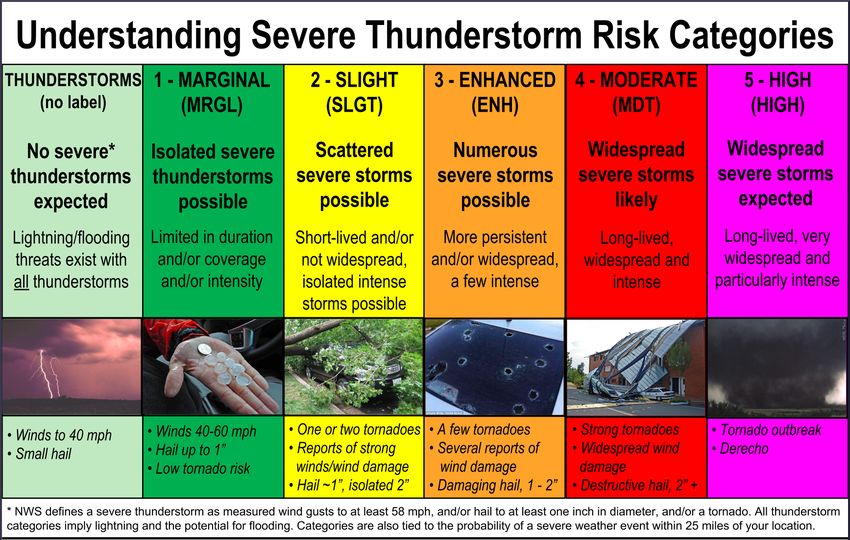
Section 4.3.11: Risk Assessment – Severe Weather

Figure 4.3.11-1. Types of Lightning

Source: Weather Underground date unknown

Hailstorms
Hail forms inside a thunderstorm or other storms with strong updrafts of warm air and downdrafts of cold water.
If a water droplet is picked up by the updrafts, it can be carried well above the freezing level. Water droplets
freeze when temperatures reach 32 degrees Fahrenheit (°F) or colder. As the frozen droplet begins to fall, it may
thaw as it moves into warmer air toward the bottom of the thunderstorm. However, the droplet may be picked
up again by another updraft and carried back into the cold air and re-freeze. With each trip above and below the
freezing level, the frozen droplet adds another layer of ice. The frozen droplet, with many layers of ice, falls to
the ground as hail. Most hail is small and typically less than 2 inches in diameter (NWS 2010). Figure 4.3.11-2
shows how hail is formed within thunderstorms.

Figure 4.3.11-2. Hail Formation in Thunderstorms

Source: Encyclopedia Britannica 2011

             DMA 2000 Hazard Mitigation Plan Update – Hunterdon County, New Jersey                         4.3.11-2
             May 2021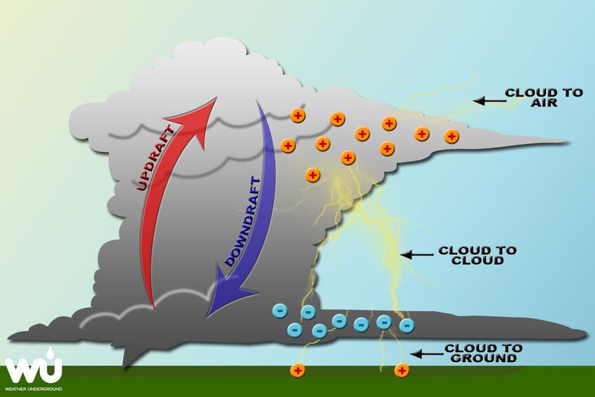
Section 4.3.11: Risk Assessment – Severe Weather

Windstorms
Wind begins with differences in air pressures and occurs through rough horizontal movement of air caused by
uneven heating of the earth’s surface. Wind occurs at all scales, from local breezes lasting a few minutes to
global winds resulting from solar heating of the earth. High winds are often associated with other severe weather
events such as thunderstorms, tornadoes, nor’easters, hurricanes, and tropical storms.

Tornadoes
A tornado appears as a rotating, funnel-shaped cloud that extends from a thunderstorm to the ground with
whirling winds that can reach 250 miles per hour (mph). Damage paths can be greater than 1 mile wide and 50
miles long. Tornadoes typically develop from either a severe thunderstorm or hurricane as cool air rapidly
overrides a layer of warm air. Tornadoes typically move at speeds between 30 and 125 mph and can generate
combined wind speeds (forward motion and speed of the whirling winds) exceeding 300 mph. The lifespan of
a tornado rarely is longer than 30 minutes (FEMA 1997). Tornadoes can occur at any time of the year, with peak
seasons at different times for different states (National Severe Storms Laboratory [NSSL] 2013).

Extreme Temperatures
Extreme temperature includes both heat and cold events that can have significant direct impacts to human health
and commercial/agricultural businesses and primary and secondary effects on infrastructure (e.g., burst pipes
and power failure). Distinguishing characteristics of “extreme cold” or “extreme heat” vary by location, based
on the conditions to which the population is accustomed. Figure 5.4.8-3 shows the average low and high
temperatures each month at the Flemington station in Hunterdon County.

Figure 4.3.11-3. Average Temperatures at Flemington

Source:   NWS 2020

Extreme Cold
Extreme cold events are when temperatures drop well below normal in an area. In regions relatively
unaccustomed to winter weather, near freezing temperatures are considered “extreme cold.” Extreme cold
temperatures are generally characterized in temperate zones by the ambient air temperature dropping to

            DMA 2000 Hazard Mitigation Plan Update – Hunterdon County, New Jersey                        4.3.11-3
            May 2021
Section 4.3.11: Risk Assessment – Severe Weather
approximately 0ºF or below (Centers of Disease Control and Prevention [CDC] 2007). Extremely cold
temperatures often accompany a winter storm, which can cause power failures and icy roads. Although staying
indoors as much as possible can help reduce the risk of car crashes and falls on the ice, individuals may also face
indoor hazards. Many homes will be too cold—either due to a power failure or because the heating system is
not adequate for the weather. The use of space heaters and fireplaces to keep warm increases the risk of
household fires and carbon monoxide poisoning (CDC 2007).
Extreme Heat
Extreme heat is defined as temperatures which hover 10 degrees or more above the average high temperature
for a region and that last for several weeks (Centers for Disease Control and Prevention [CDC] 2016). A heat
wave is defined as a period of abnormally and uncomfortably hot and unusually humid weather. Typically, a
heat wave lasts two or more days. (National Weather Service [NWS] 2009). There is no universal definition of
a heat wave because the term is relative to the usual weather in a particular area. The term heat wave is applied
both to routine weather variations and to extraordinary spells of heat which may occur only once a century
(Meehl and Tebaldi 2004).
Urbanized areas and urbanization creates an exacerbated type of risk during an extreme heat event, compared to
rural and suburban areas. As defined by the U.S. Census, urban areas are classified as all territory, population,
and housing units located within urbanized areas and urban clusters. The term urbanized area denotes an urban
area of 50,000 or more people. Urban areas under 50,000 people are called urban clusters. The U.S. Census
delineates urbanized area and urban cluster boundaries to encompass densely settled territory, which generally
consists of:
A cluster of one or more block groups or census blocks each of which has a population density of at least
1,000 people per square mile at the time.
Surrounding block groups and census blocks each of which has a population density of at least 500 people
per square mile at the time.
Less densely settled blocks that form enclaves or indentations or are used to connect discontiguous areas
with qualifying densities (U.S. Census 2010).
As these urban areas develop and change, so does the landscape. Buildings, roads, and other infrastructure
replace open land and vegetation. Surfaces that were once permeable and moist are now impermeable and dry.
These changes cause urban areas to become warmer than the surrounding areas. This forms an ‘island’ of higher
temperatures (U.S. Environmental Protection Agency [EPA] 2009).
The term ‘heat island’ describes built up areas that are hotter than nearby rural areas. The annual mean air
temperature of a city with more than one million people can be between 1.8 ºF and 5.4ºF warmer than its
surrounding areas. In the evening, the difference in air temperatures can be as high as 22ºF. Heat islands occur
on the surface and in the atmosphere. On a hot, sunny day, the sun can heat dry, exposed urban surfaces to
temperatures 50ºF to 90ºF hotter than the air. Heat islands can affect communities by increasing peak energy
demand during the summer, air conditioning costs, air pollution and greenhouse gas emissions, heat-related
illness and death, and water quality degradation (EPA 2010 and 2011).
Urbanized areas and urbanization creates an exacerbated type of risk during an extreme heat event, compared to
rural and suburban areas. As defined by the U.S. Census, urban areas are classified as all territory, population,
and housing units located within urbanized areas and urban clusters. The term urbanized area denotes an urban
area of 50,000 or more people. Urban areas under 50,000 people are called urban clusters. The U.S. Census
delineates urbanized area and urban cluster boundaries to encompass densely settled territory, which generally
consists of:
DMA 2000 Hazard Mitigation Plan Update – Hunterdon County, New Jersey 4.3.11-4
May 2021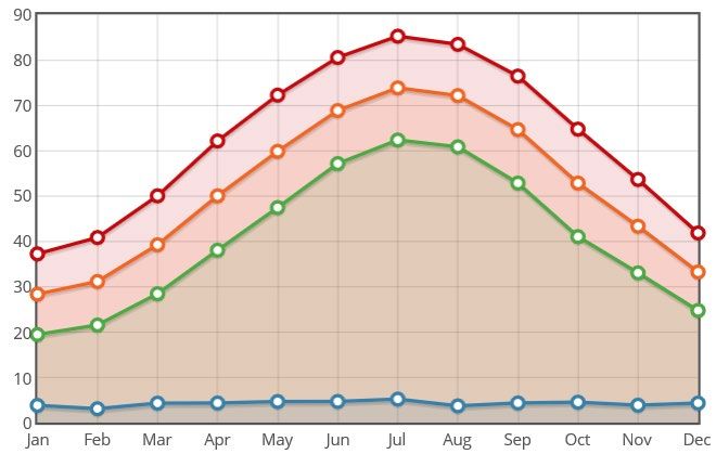
Section 4.3.11: Risk Assessment – Severe Weather
A cluster of one or more block groups or census blocks each of which has a population density of at least
1,000 people per square mile at the time.
Surrounding block groups and census blocks each of which has a population density of at least 500 people
per square mile at the time.
Less densely settled blocks that form enclaves or indentations, or are used to connect discontiguous areas
with qualifying densities (U.S. Census 2010).
As urban areas develop and change, so does the landscape. Buildings, roads, and other infrastructure replace
open land and vegetation. Surfaces that were once permeable and moist are now impermeable and dry. These
changes cause urban areas to become warmer than the surrounding areas. This forms an ‘island’ of higher
temperatures (U.S. EPA 2019).
The term ‘heat island’ describes built up areas that are hotter than nearby rural areas. The annual mean air
temperature of a city with more than one million people can be between 1.8 ºF and 5.4ºF warmer than its
surrounding areas. In the evening, the difference in air temperatures can be as high as 22ºF. Heat islands occur
on the surface and in the atmosphere. On a hot, sunny day, the sun can heat dry, exposed urban surfaces to
temperatures 50ºF to 90ºF hotter than the air. Heat islands can affect communities by increasing peak energy
demand during the summer, air conditioning costs, air pollution and greenhouse gas emissions, heat-related
illness and death, and water quality degradation (U.S. EPA 2019).
Figure 4.3.11-4 below illustrates an urban heat island profile. The graphic demonstrates that heat islands are
typically most intense over dense urban areas. Further, vegetation and parks within a downtown area may help
reduce heat islands (U.S. EPA 2019).
Figure 4.3.11-4. Urban Heat Island Profile
Source: EPA 2019
ºC degrees Celsius
DMA 2000 Hazard Mitigation Plan Update – Hunterdon County, New Jersey 4.3.11-5
May 2021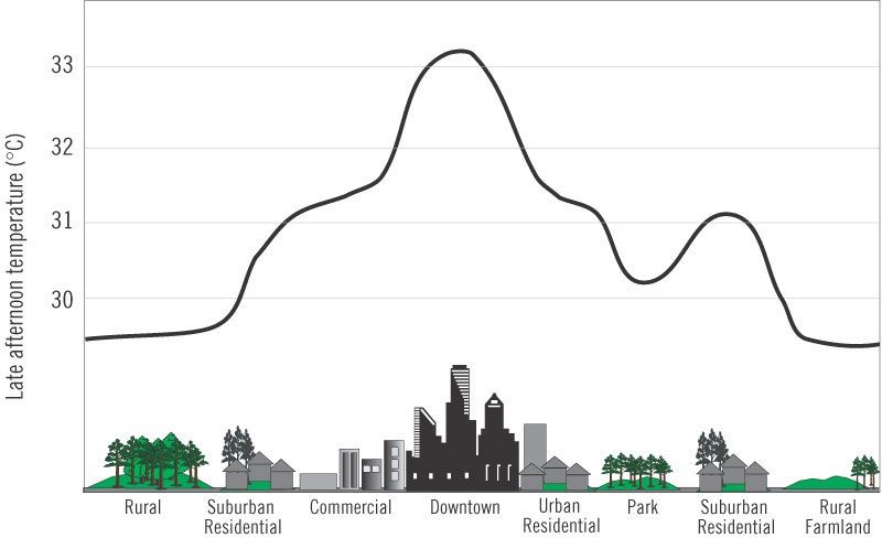
Section 4.3.11: Risk Assessment – Severe Weather

Location

All of Hunterdon County is exposed to severe weather. According to the FEMA Winds Zones of the United
States map, Hunterdon County is located in Wind Zone II, where wind speeds can reach up to 160 mph and is
part of the hurricane susceptible region. Figure 4.3.11-5 illustrates wind zones across the United States, which
indicate the impacts of the strength and frequency of wind activity per region. The information on the figure is
based on 40 years of tornado data and 100 years of hurricane data collected by FEMA.

Figure 4.3.11-5. Wind Zones in the United States

Source:   FEMA 2012
Note:     The red circle indicates the approximate location of Hunterdon County.

According to the ONJSC, New Jersey has five distinct climate regions. Elevations, latitude, distance from the
Atlantic Ocean, and landscape (e.g. urban, sandy soil) produce distinct variations in the daily weather between
each of the regions. The five regions include: Northern, Central, Pine Barrens, Southwest, and Coastal (ONJSC
Rutgers University n.d.). Figure 4.3.11-6 depicts these regions. Hunterdon County is located within the
Northern Climate Region.

The Northern Region covers about one-quarter of New Jersey and consists mainly of elevated highlands and
valleys which are part of the Appalachian Uplands. Surrounded by land, this region can be characterized as

             DMA 2000 Hazard Mitigation Plan Update – Hunterdon County, New Jersey                              4.3.11-6
             May 2021
Section 4.3.11: Risk Assessment – Severe Weather
having a continental type of climate with minimal influence from the Atlantic Ocean, except when the winds
contain an easterly component. Prevailing winds are from the southwest in summer and from the northwest in
winter. Being in the northernmost portion of the state, and with small mountains up to 1800 feet in elevation, the
Northern Zone normally exhibits a colder temperature regime than other climate regions of the State. This
difference is most dramatic in winter when average temperatures in the Northern Zone can be more than ten
degrees Fahrenheit cooler than in the Coastal Zone. A storm track extending from the heart of the Mississippi
Valley, over the Great Lakes, and along the St. Lawrence Valley is a major source of precipitation for this region.
Coastal storms, with precipitation shields that reach well enough inland add to the precipitation totals. During
the warm season, thunderstorms are responsible for most of the rainfall. Cyclones and frontal passages are less
frequent during this time. Thunderstorms spawned in Pennsylvania and New York State often move into
Northern New Jersey, where they often reach maximum development in the evening. This region has about twice
as many thunderstorms as the coastal zone, where the nearby ocean helps stabilize the atmosphere. The Northern
Climate Zone usually has the shortest growing season, about 155 days. The average date for the last killing
Spring frost is May 4. The first frost in Fall is around October 7. The exact dates vary significantly within the
region as well as from year to year. Some valley locations have observed killing frost in mid-September and as
late as mid-June. (ONJSC Rutgers University n.d.).
Figure 4.3.11-6. Climate Regions of New Jersey
Source: ONJSC Rutgers University n.d.
Note: The red circle indicates the location of Hunterdon County. The County is located in the North Climate Zone of New
Jersey.
DMA 2000 Hazard Mitigation Plan Update – Hunterdon County, New Jersey 4.3.11-7
May 2021Section 4.3.11: Risk Assessment – Severe Weather
Extent
The extent (severity or magnitude) of a severe storm is largely dependent upon the most damaging aspects of
each type of severe weather. This section describes the extent of thunderstorms, lighting, hail, windstorms, and
tornadoes in Hunterdon County. Historical data presented in Error! Reference source not found. shows the
most powerful severe weather records in Hunterdon County.
Table 4.3.11-1. Severe Storm Extent in Hunterdon County (1950-2020)
Extent of Severe Storms in Hunterdon County
Largest Hailstone on Record 1.75 inches
Strongest Tornado on Record F-2
Highest Wind Speed on
71 knots
Record
Source: NOAA-NCEI 2020
Thunderstorms
NWS considers a thunderstorm severe if it produces damaging wind gusts of 58 mph or higher, hail 1 inch
(quarter size) in diameter or larger, or tornadoes (NWS 2010). Severe thunderstorm watches and warnings are
issued by the local NWS office and NOAA’s Storm Prediction Center (SPC). NWS and SPC will update the
watches and warnings and will notify the public when they are no longer in effect. Watches and warnings for
thunderstorms in New Jersey are defined as follows:
Severe Thunderstorm Warnings are issued when there is evidence based on radar or a reliable spotter report
that a thunderstorm is producing (or is forecast to produce) wind gusts of 58 mph or greater, structural wind
damage, and hail 1 inch in diameter or greater. A warning will include the location of the storm, the
municipalities that are expected to be impacted, and the primary threat associated with the severe
thunderstorm warning. After it has been issued, the NWS office will follow up periodically with Severe
Weather Statements, which contain updated information on the severe thunderstorm and will let the public
know when the warning is no longer in effect (NWS 2010).
Severe Thunderstorm Watches are issued by the SPC when conditions are favorable for the development of
severe thunderstorms over a larger-scale region for a duration of at least 3 hours. Tornadoes are not expected
in such situations, but isolated tornado development may also occur. Watches are normally issued well in
advance of the actual occurrence of severe weather. During the watch, NWS will keep the public informed
on developments happening in the watch area and will also notify the public when the watch has expired or
been cancelled (NWS 2010).
Special Weather State for Near Severe Thunderstorms bulletins are issued for strong thunderstorms that are
below severe levels, but still may have some adverse impacts. Usually, they are issued for the threat of wind
gusts of 40 to 58 mph or small hail less than one (1) inch in diameter (NWS 2010).
In addition, the SPC issues severe thunderstorm risk maps based on the likelihood of different severities of
thunderstorms. Table 4.3.11-7 shows the SPC’s severe thunderstorm risk categories.
DMA 2000 Hazard Mitigation Plan Update – Hunterdon County, New Jersey 4.3.11-8
May 2021Section 4.3.11: Risk Assessment – Severe Weather
Figure 4.3.11-7. Severe Thunderstorm Risk Categories
Source: NOAA SPC 2017
Lightning
Lightning is most often associated with moderate to severe thunderstorms. The severity of lightning refers to the
frequency of lightning strikes during a storm. Multiple devices are available to track and monitor the frequency
of lightning.
Hail
The severity of a hailstorm is measured by duration, hail size, and geographic extent. Most hail stones from
hailstorms are made up of variety of sizes. The size of hail is estimated by comparing it to a known object. Table
4.3.11-2 describes the different sizes of hail as compared to real-world objects and lists approximate
measurements.
Table 4.3.11-2. Hail Size
Diameter Diameter
Description (in inches) Description (in inches)
Pea 0.25 Golf ball 1.75
Marble or mothball 0.50 Hen’s egg 2.00
Penny or dime 0.75 Tennis ball 2.5
Nickel 0.88 Baseball 2.75
Quarter 1.00 Tea cup 3.00
DMA 2000 Hazard Mitigation Plan Update – Hunterdon County, New Jersey 4.3.11-9
May 2021Section 4.3.11: Risk Assessment – Severe Weather
Diameter Diameter
Description (in inches) Description (in inches)
Half dollar 1.25 Grapefruit 4.00
Walnut or ping pong ball 1.50 Softball 4.50
Source: NOAA 2012
Windstorms
Table 4.3.11-3 provides the NWS descriptions of winds during wind-producing events.
Table 4.3.11-3. NWS Wind Descriptions
Sustained Wind Speed
Descriptive Term (mph)
Strong, dangerous, or damaging ≥40
Very windy 30-40
Windy 20-30
Breezy, brisk, or blustery 15-25
None 5-15 or 10-20
Light or light and variable wind 0-5
Source: NWS 2015
NWS issues advisories and warnings for winds, which are normally site-specific. High wind advisories,
watches, and warnings are issued by the NWS when wind speeds may pose a hazard or may be life
threatening. The criterion for each of these varies from state to state. Wind warnings and advisories for New
Jersey are as follows:
High Wind Warnings are issued when sustained winds of 40 mph or greater are forecast for 1 hour or longer,
or wind gusts of 58 mph or greater are forecast for any duration.
Wind Advisories are issued when sustained winds of 30 to 39 mph are forecast for one 1 hour or longer, or
wind gusts of 46 to 57 mph are forecast for any duration (NWS 2015).
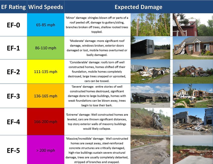
Tornado
The magnitude or severity of a tornado is categorized using the Enhanced Fujita Tornado Intensity Scale (EF
Scale). Table 4.3.11-8 illustrates the relationship between EF ratings, wind speed, and expected tornado damage.
DMA 2000 Hazard Mitigation Plan Update – Hunterdon County, New Jersey 4.3.11-10
May 2021Section 4.3.11: Risk Assessment – Severe Weather
Figure 4.3.11-8. Enhanced Fujita Tornado Intensity Scale Ratings, Wind Speeds, and Expected Damage
Source: NWS 2018
Tornado watches and warning are issued by the local NWS office. A tornado watch is released when tornadoes
are possible in an area. A tornado warning means a tornado has been sighted or indicated by weather radar. The
current average lead time for tornado warnings is 13 minutes. Occasionally, tornadoes develop so rapidly, that
little, if any, advance warning is possible (NOAA 2011).
Extreme Heat
NOAA’s heat alert procedures are based mainly on Heat Index values. The Heat Index is given in degrees
Fahrenheit. The Heat Index is a measure of how hot it really feels when relative humidity is factored in with the
actual air temperature. To find the Heat Index temperature, the temperature and relative humidity need to be
known. Once both values are known, the Heat Index will be the corresponding number with both values (Figure
5.4.8-1). The Heat Index indicated the temperature the body feels. It is important to know that the Heat Index
values are devised for shady, light wind conditions. Exposure to full sunshine can increase heat index values by
up to 15°F. Strong winds, particularly with very hot dry air, can also be extremely hazardous (NWS 2013).
DMA 2000 Hazard Mitigation Plan Update – Hunterdon County, New Jersey 4.3.11-11
May 2021Section 4.3.11: Risk Assessment – Severe Weather
Figure 4.3.11-9. NWS Heat Index Chart
Source: NWS 2015c
°F degrees Fahrenheit
% percent
Figure 4.3.11-10. Adverse Effects of Prolonged Exposures to Heat on Individuals
Category Heat Index Health Hazards
Extreme Danger 130 °F – Higher Heat Stroke / Sunstroke is likely with continued exposure.
Sunstroke, muscle cramps, and/or heat exhaustion possible with
Danger 105 °F – 129 °F
prolonged exposure and/or physical activity.
Sunstroke, muscle cramps, and/or heat exhaustions possible with
Extreme Caution 90 °F – 105 °F
prolonged exposure and/or physical activity.
Caution 80 °F – 90 °F Fatigue possible with prolonged exposure and/or physical activity.
Source: NWS 2009
°F degrees Fahrenheit
Extreme Cold
The extent (severity or magnitude) of extreme cold temperatures are generally measured through the Wind Chill
Temperature (WCT) Index. Wind Chill Temperature is the temperature that people and animals feel when
outside and it is based on the rate of heat loss from exposed skin by the effects of wind and cold. As the wind
increases, the body is cooled at a faster rate causing the skin’s temperature to drop (NWS n.d.).
On November 1, 2001, the NWS implemented a new WCT Index. It was designed to more accurately calculate
how cold air feels on human skin. The table below shows the new WCT Index. The WCT Index includes a
frostbite indicator, showing points where temperature, wind speed, and exposure time will produce frostbite to
humans. Figure 5.4.8-3 shows three shaded areas of frostbite danger. Each shaded area shows how long a person
can be exposed before frostbite develops (NWS n.d.).
DMA 2000 Hazard Mitigation Plan Update – Hunterdon County, New Jersey 4.3.11-12
May 2021Section 4.3.11: Risk Assessment – Severe Weather
Figure 4.3.11-11. NWS Wind Chill Index
Source: NWS n.d.
°F degrees Fahrenheit
mph miles per hour
Warning Time
Meteorologists can accurately forecast extreme temperature event development and the severity of the associated
conditions with several days lead time. These forecasts provide an opportunity for public health and other
officials to notify vulnerable populations. For heat events, the NWS issues excessive heat outlooks when the
potential exists for an excessive heat event in the next three to seven days. Watches are issued when conditions
are favorable for an excessive heat event in the next 24 to 72 hours. Excessive heat warning/advisories are issued
when an excessive heat event is expected in the next 36 hours. Winter temperatures may fall to extreme cold
readings with no wind occurring. Currently, the only way to headline very cold temperatures is with the use of
the NWS-designated Wind Chill Advisory or Warning products. When actual temperatures reach Wind Chill
Warning criteria with little to no wind, extreme cold warnings may be issued (NWS n.d.).
Previous Occurrences and Losses
Federal Disaster Declarations
Between 1954 and January 2020, Hunterdon County has been included in six declarations for severe storm-
related events classified as one or a combination of the following disaster types: severe storm, straight-line winds,
or tornado (FEMA 2020). Table 4.3.11-4 lists these events.
Table 4.3.11-4. Severe Storm-related FEMA Disaster Declarations
Declaration Event Date Declaration Date Event Description
September 18 - October 1,
DR-1563 October 1, 2004 Severe Storms and Flooding
2004
DMA 2000 Hazard Mitigation Plan Update – Hunterdon County, New Jersey 4.3.11-13
May 2021Section 4.3.11: Risk Assessment – Severe Weather
Declaration Event Date Declaration Date Event Description
DR-1588 April 1-3, 2005 April 19, 2005 Severe Storms and Flooding
DR-1653 June 23 - July 10, 2006 July 7, 2006 Severe Storms and Flooding
DR-1897 March 12 - April 15, 2010 April 2, 2010 Severe Storms and Flooding
September 28 - October 6, Remnants of Tropical Storm
DR-4039 October 14, 2011
2011 Lee
DR-4048 October 29, 2011 November 30, 2011 Severe Storm
Source: FEMA 2020
USDA Disaster Declarations
Agriculture-related disasters are quite common. The USDA Secretary of Agriculture is authorized to designate
counties as disaster areas to make emergency loans to producers suffering losses in those counties and in counties
that are contiguous to a designated county. In 2019, Hunterdon County was included in declaration S4454 for
excessive rain and moisture and declaration S4455 for the combined effects of excessive rainfall, moisture, and
storm-force winds from Hurricane Florence. In 2019, indemnities for moisture/precipitation/rain for all other
crops totaled $162,652.70.
Severe Weather Events
Severe weather events that have impacted Hunterdon County between 2015 and 2020 are identified in Table
4.3.11-5. With severe weather documentation for New Jersey and Hunterdon County being so extensive, not all
sources have been identified or researched. Therefore, Error! Reference source not found. may not include
all events that have occurred in the County. Please see Section 9 (Jurisdictional Annexes) for detailed
information regarding impacts and losses to each municipality.
DMA 2000 Hazard Mitigation Plan Update – Hunterdon County, New Jersey 4.3.11-14
May 2021Section 4.3.11: Risk Assessment – Severe Weather
Table 4.3.11-5. Severe Weather Events in Hunterdon County, 2015 to 2020
FEMA
Declaration Hunterdon
Date(s) of Number County
Event Event Type (if applicable) Designated? Location Description
The arrival of an arctic air mass brought
one of the coldest mornings of the month
of January to most of New Jersey.
Morning low temperatures were mainly
in the single numbers above zero. In
addition, gusty northwest winds
continued into the morning and lowest
hourly wind chill factors reached around
degrees below zero throughout the state.
Actual low temperatures were 6 degrees
above zero in Flemington (Hunterdon
January 7-8, Cold/Wind Hunterdon
N/A N/A County), As the arctic high pressure
2015 Chill County
system entered the United States near
Montana, its surface pressure was quite
high: 1058 millibars at 4 a.m. EST on
January 7th. At 7 a.m. EST on the 8th, it
weakened to 1041 millibars and was
located near Memphis, Tennessee. From
there, the high pressure system moved
east. This reduced the wind and also
brought the region a relatively warmer
return flow from the southwest on the
night of the 8th.
Strong, gusty northwest winds occurred
in the wake of a departing and
intensifying low pressure system during
the late afternoon into the middle of the
evening on the 2nd in New Jersey. Peak
Hunterdon
February 2, 2015 Strong Wind N/A N/A wind gusts average around 50 mph and
County
knocked down weak trees, tree limbs and
wires. Scattered power outages occurred.
This was further exacerbated by snow
and ice on tree limbs in the northwest
part of the state.
Northwest winds that persisted into the
morning of the 13th combined with an
arctic air mass to produce wind chill
February 13, Cold/Wind Hunterdon factors of around 10 degrees below zero
N/A N/A
2015 Chill County and low temperatures in the positive
single numbers throughout most of New
Jersey and claimed the life of one
homeless man in Burlington County.
The increasing pressure difference
(gradient) between a rapidly intensifying
low pressure system offshore and an
arctic high pressure system moving east
from the Great Lakes caused strong to
high damaging northwest winds to occur
in New Jersey from the late evening of
February 15, Hunterdon
Strong Wind N/A N/A the 14th into the afternoon of the 15th.
2015 County
Strong wind gusts started late in the
evening on the 14th, peaked during the
morning of the 15th and continued into
the afternoon of the 15th. The strong to
high winds caused isolated property
damage (mainly stripped siding),
knocked down or snapped numerous trees
DMA 2000 Hazard Mitigation Plan Update – Hunterdon County, New Jersey 4.3.11-15
May 2021Section 4.3.11: Risk Assessment – Severe Weather
FEMA
Declaration Hunterdon
Date(s) of Number County
Event Event Type (if applicable) Designated? Location Description
and tree limbs. This resulted in downed
wires and power outages. About 5,000
homes and businesses lost power, mainly
in southeast New Jersey. Nearly all
power was restored on the evening of the
15th. The strong to high winds hampered
road crews trying to keep roadways clear
from the snow that fell on the 14th. It
also ushered into New Jersey one of the
coldest air masses of the entire winter
season. Peak wind gusts included and 45
mph in Readington (Hunterdon County).
The near arrival of the center of the arctic
air mass brought some of the lowest wind
chills and temperatures of the winter
season to New Jersey. While winds by
the morning of the 16th were not as
strong as they were on the morning of the
15th, air temperatures were lower. This
produced wind chill factors as low as
around 20 degrees below zero in most of
the state. Actual low temperatures were
around zero.
February 15-16, Cold/Wind Hunterdon Outreach teams were dispatched to get
N/A N/A
2015 Chill County homeless people to shelters. Code Blues
remained in effect. The extreme cold
weather continued to cause pipes to
freeze and many dead batteries. AAA
Mid-Atlantic responded to more than
1,600 dead battery calls. Plumbers said
they have not been this busy with frozen
pipes in over 20 years.
Actual low temperatures included 2
degrees below zero in Kingwood
(Hunterdon County).
The arrival of another arctic air mass
brought some of the lowest wind chills as
well as the lowest temperatures of the
winter season to New Jersey on the 20th
and 21st. As far as wind chill factors
went, the first half of the day on the 20th
was colder with wind chill factors as low
as around 20 degrees below zero during
the morning. Actual low temperatures
February 20, Cold/Wind Hunterdon were around zero. On the morning of the
N/A N/A
2015 Chill County 21st, little, if any, wind was present as the
arctic high pressure system was nearby.
Low temperatures in more rural inland
areas were lower, many were below zero,
some well below zero. But, because of
the lack of wind, wind chill factors nearly
matched the air temperatures and it felt
relatively warmer on the morning of the
21st.
DMA 2000 Hazard Mitigation Plan Update – Hunterdon County, New Jersey 4.3.11-16
May 2021Section 4.3.11: Risk Assessment – Severe Weather
FEMA
Declaration Hunterdon
Date(s) of Number County
Event Event Type (if applicable) Designated? Location Description
Actual lowest temperatures on either the
20th or 21st included 7 degrees below
zero in Kingwood (Hunterdon County).
The high pressure system responsible for
third and last arctic blast of the month of
February arrived in New Jersey on the
morning of the 24th. Unlike the two
previous arctic outbreaks earlier this
month, this one was not accompanied by
strong winds during the first half of the
day. Air and wind chill temperatures
were nearly the same. The calm
conditions and snow cover combined to
give many locations in northwest New
Jersey the coldest morning of the winter
February 24, Cold/Wind Hunterdon
N/A N/A season and comparably cold to the 20th
2015 Chill County
and 21st weather in the rest of the state.
Morning low temperatures averaged 25 to
35 degrees colder than normal. The
multiple arctic intrusions in New Jersey
made this month one of the coldest
Februaries on record. Actual low
temperatures included 14 degrees below
zero in Kingwood (Hunterdon County).
Since 1895, this February ranked as the
6th coldest on record with an average
statewide temperature of 22.3 degrees
(11.2 degrees below average).
Strong, gusty northwest winds circulating
around an intensifying low pressure
system and approaching high pressure
system had the greatest impact across
northern New Jersey and coastal southern
New Jersey during the second half of the
morning into the afternoon on the 4th.
Hunterdon
April 4, 2015 Strong Wind N/A N/A Peak wind gusts in these areas reached
County
between 45 mph and 50 mph and
knocked down weak tree limbs and wires.
In the rest of the southern half of the
state, while still windy, most peak wind
gusts were less than 40 mph.
Peak wind gusts included 44 mph in
Alexandria (Hunterdon County).
Unseasonably hot and humid weather
affected most of New Jersey on the 19th
and 20th. High temperatures in most
areas reached into the lower to mid 90s
both days. The 19th was slightly hotter
Hunterdon and more humid overall. The
July 19, 2015 Heat N/A N/A
County combination of heat and humidity
brought afternoon heat index values as
high as 100F to 105F on the 19th. These
were some of the highest heat index
values of the entire summer. A
dissipating cold front on the 20th brought
DMA 2000 Hazard Mitigation Plan Update – Hunterdon County, New Jersey 4.3.11-17
May 2021Section 4.3.11: Risk Assessment – Severe Weather
FEMA
Declaration Hunterdon
Date(s) of Number County
Event Event Type (if applicable) Designated? Location Description
slightly drier air into the region during
the afternoon of the 20th and heat index
values peaked around 100F . A re-
enforcing cold frontal passage on the 21st
brought even cooler and drier air into the
area and by the 22nd all high
temperatures were less than 90 degrees in
New Jersey.
To combat the heat, many counties,
cities and municipalities opened cooling
centers. Highest temperatures included 91
degrees in Flemington (Hunterdon
County).
Bitter cold temperatures and strong
northwest winds associated with an
Arctic outbreak combined to create
dangerous wind chill temperatures across
the entire northeast quadrant of the
county beginning Saturday morning,
February 14, Cold/Wind Hunterdon
N/A N/A February 13th into Sunday afternoon,
2016 Chill County
February 14th. The lowest wind chill
values were reported at the following
locations during the early morning hours
of February 14th: 22 degrees below zero
in Glen Gardner and 20 degrees below
zero in Frenchtown.
A strong low pressure system moving
north through the Great Lakes region,
combined with its associated warm front
and cold front, copious amounts of
moisture, and low level jet, produced
strong to severe thunderstorms, heavy
rain, flash flooding, and stream flooding
February 24, Thunderstorm East Amwell in New Jersey late Wednesday afternoon
N/A N/A
2016 Wind Township and evening, February 24th, with stream
flooding continuing into Thursday,
February 25th. Thousands were without
power for a period across the state,
focused in South Jersey. Measured
thunderstorm wind gust of 60 MPH in
East Amwell Township, along with pea
size hail.
A narrow band of showers and
thunderstorms formed ahead of a cold
front which moved through the region.
The band of showers and thunderstorms
moved through New Jersey in the late
afternoon and evening hours of the 1st.
Thunderstorm Delaware
April 1, 2016 N/A N/A Some gusty winds and hail occurred with
Wind Township.
a few of the thunderstorms. Most of the
hail and gusty winds that occurred were
below severe limits. Wires were reported
down due to thunderstorm winds in
Delaware Township in Hunterdon
County at 6:08 pm.
DMA 2000 Hazard Mitigation Plan Update – Hunterdon County, New Jersey 4.3.11-18
May 2021Section 4.3.11: Risk Assessment – Severe Weather
FEMA
Declaration Hunterdon
Date(s) of Number County
Event Event Type (if applicable) Designated? Location Description
A strong cold front associated with a low
pressure system moving through New
York State swept across the area during
the late evening hours of April 2nd and
early morning hours of April 3rd,
accompanied by thunderstorms, very
strong convectively driven winds, and
small hail. As colder air behind this front
drained south, precipitation changed to
snow, with up to three inches falling in
the higher elevations of northwest New
Jersey and lesser amounts in isolated
spots through most of New Jersey. The
Readington parent low pressure system then quickly
April 3, 2016 High Wind N/A N/A
Township intensified as it continued to move
northeast away from the area. The
gradient between this low pressure
system and incoming high pressure
produced strong winds gusting over 60
MPH in some localities from late
overnight through the morning hours of
April 3rd.
Some reported peak wind gusts included:
46 MPH near Frenchtown at 1040EST
(Hunterdon County). Strong gradient
winds following the passage of a strong
cold front snapped a tree in Readington,
which then snapped a power pole.
A cold front and associated pre-frontal
trough lead to the development of
Thunderstorm Readington thunderstorms in the afternoon and
July 18, 2016 N/A N/A
Wind Township evening hours.
Several trees down in Readington
Township due to thunderstorm winds.
A trough of low pressure led to the
development of afternoon and evening
showers and thunderstorms which
Lambertville,
became severe in spots and produced
Milford,
locally heavy rains. 40,000 were left
Thunderstorm Wertsville,
without power across the state. Numerous
July 25, 2016 Wind, N/A N/A Readington
trees are wires were downed in
Tornado Township,
Lambertville, Milford, Wertsville due to
Branchburg
thunderstorm wind gusts. Thunderstorms
Township
produced a EF-1 tornado in Readington
and Branchburg Townships. Maximum
winds reached 90 mph.
A weak trough of low pressure moved
through the region which led to the
development of showers and
Stockton and
Thunderstorm thunderstorms. Some of the storms
August 12, 2016 N/A N/A Sergeantsville
Wind became severe and produced heavy
areas.
rainfall. Trees and wires downed due to
thunderstorm winds in the Stockton and
Sergeantsville areas.
Although a very unstable airmass was
Cherryville,
present coupled with ample shear only a
May 31, 2017 Hail N/A N/A Pittstown,
few thunderstorms formed due to the lack
Flemington
of a lifting feature across the region. One
DMA 2000 Hazard Mitigation Plan Update – Hunterdon County, New Jersey 4.3.11-19
May 2021Section 4.3.11: Risk Assessment – Severe Weather
FEMA
Declaration Hunterdon
Date(s) of Number County
Event Event Type (if applicable) Designated? Location Description
thunderstorm became severe tracking
northeast from Hunterdon into Somerset
and Sussex counties. Numerous hail
reports of .5 and .75 inch were recorded.
A couple of the reports met severe
criteria.
A complex of thunderstorms came
through the region during the evening
producing high winds and heavy rain.
Thunderstorm
June 19, 2017 N/A N/A Barbertown Wind damage occurred in several
Wind
locations from the thunderstorms. A few
trees were blown down by wind. Time
estimated from radar.
Thunderstorm Several large trees were downed due to
June 23, 2017 N/A N/A Lebanon
Wind thunderstorm winds.
Strong to severe thunderstorms ahead of
Delaware, East
a cold front decayed as they moved east
Thunderstorm Amwell and
July 1, 2017 N/A N/A into New Jersey. Several trees and wires
Wind West Amwell
blown down in Delaware, East Amwell
Townships
and West Amwell townships.
A hot and humid airmass was present
ahead of a frontal boundary which slowly
moved southeast toward and then through
the state. Several rounds of
Thunderstorm
July 13, 2017 N/A N/A Pleasant Run thunderstorms moved through the region
Wind
ahead of this front over the course of a
few days. Several telephone polls taken
down along route 202 from thunderstorm
winds.
A complex of severe thunderstorms
moved southeast across northern portions
of state producing wind damage before
weakening as it reached central portions
Thunderstorm Stockton, Mt
July 20, 2017 N/A N/A of the state. Lightning struck several trees
Wind Airy
on the night of the 20th which created a
3,500 acre fire that burned for a few days.
Thunderstorm winds took down trees and
powerlines in several spots.
Severe thunderstorms formed in a hot and
Thunderstorm humid airmass ahead of a cold front.
August 18, 2017 N/A N/A Pleasant Run
Wind Thunderstorm winds took down trees and
wires throughout the township.
Severe thunderstorms formed in a hot and
humid airmass ahead of a cold front.
Thunderstorm winds took down trees and
Pittstown wires which caught on fire at Pittstown
Airport, Glen Airport. Thunderstorm winds took down
Thunderstorm Gardner, numerous trees and wires in the Glen
August 22, 2017 N/A N/A
Wind Riegel Ridge, Gardner area. Thunderstorm winds took
Flemington, down trees and wires on Milford Warren
Linvale Glen road. A tree fell onto a car due to
thunderstorm wind in Flemington.
Thunderstorm winds blew a tree down
onto NJ 31 in Linvale.
DMA 2000 Hazard Mitigation Plan Update – Hunterdon County, New Jersey 4.3.11-20
May 2021Section 4.3.11: Risk Assessment – Severe Weather
FEMA
Declaration Hunterdon
Date(s) of Number County
Event Event Type (if applicable) Designated? Location Description
A cold front stalled across the region on
March 1st. Meanwhile, a wave of low
pressure developed along this front in the
Ohio Valley and move east, deepening
just southeast of Long Island on March
2nd. This large and very deep area of low
pressure moved slowly east over the open
waters of the North Atlantic Ocean
through Sunday March 4th. This lead to a
variety of weather hazards during this
time frame.
Strong northwest winds with gusts to
over 60 MPH occurred on March 2nd and
Hunterdon 3rd. This led to widespread damage to
March 2, 2018 High Wind N/A N/A
County trees and power lines, which in turn
induced extensive power outages across
the region. At one point more than 29,000
customers were without power in
Hunterdon County. A wind gust of 71
MPH was reported by a trained spotter in
Lebanon at 1800EST on March 2nd. A
downed tree closed a ramp onto I-78 in
Clinton Township. Heavy rainfall
occurred over west-central New Jersey on
March 1st and 2nd, with widespread
rainfall amounts of 1 to 2 inches. Areal
and minor small stream flooding
occurred.
Low pressure developed over the Central
Plains on April 3rd, deepening as it
moved into the Saint Lawrence Valley on
April 3rd and to Prince Edward Island on
April 4th, due to a significant contrast in
air masses with Continental Polar air to
the north and Maritime Tropical air to the
Hunterdon
March 4, 2018 High Wind N/A N/A south. This lead to a strong cold frontal
County
passage across the region on April 4th. In
the wake of this front, colder air moving
into the area and a tight pressure gradient
lead to widespread damaging west-
northwest wind gusts in excess of 50 mph
on April 4th. A trained spotter reported a
tree down in Allerton.
Severe thunderstorms moved across
Thunderstorm portions of northern New Jersey with hail
May 15, 2018 N/A N/A Hampton
Wind and wind damage reported. Multiple trees
and power lines down.
Severe thunderstorms caused wind
damage across portions of New Jersey. A
Thunderstorm
June 18, 2018 N/A N/A Barbertown 12+ inch diameter oak tree snapped off
Wind
approximately 10 feet above the ground.
Time estimated from radar.
Temperatures in the middle to upper 90s
and dew points in the upper 60s to lower
Excessive Hunterdon 70s led to excessive heat across portions
July 1-3, 2018 N/A N/A
Heat County of southeastern Pennsylvania. Heat
indices reached 111 degrees at the
Somerset Airport ASOS on July 3rd.
DMA 2000 Hazard Mitigation Plan Update – Hunterdon County, New Jersey 4.3.11-21
May 2021Section 4.3.11: Risk Assessment – Severe Weather
FEMA
Declaration Hunterdon
Date(s) of Number County
Event Event Type (if applicable) Designated? Location Description
Severe thunderstorms and flash flooding
Thunderstorm impacted eastern PA and central/northern
July 17, 2018 N/A N/A Glen Gardner
Wind NJ. Trees were downed onto wires in
Glen Gardner.
Severe thunderstorms and flash flooding
Thunderstorm impacted eastern PA and central/northern
August 17, 2018 N/A N/A Lebanon
Wind NJ. Trained spotter estimates 65 mph
wind gust.
Supercellular severe thunderstorms
caused 2 tornadoes, wind damage, and
hail across the region all part of a record
Thunderstorm
October 2, 2018 N/A N/A Rocktown breaking tornado outbreak across
Wind
Pennsylvania.
Tree down on US 202 south of Route 31.
Left and center lanes blocked.
A departing very deep cyclone combined
with strong high pressure to the west
yielded a strong pressure gradient from
the Plains eastward to the northern Mid-
February 25, Atlantic and New England regions. High
High Wind N/A N/A Hopewell
2019 winds gusting 50-60 mph resulted in
scattered power outages and trees down
across the region. Some minor structural
damage also occurred. Utility pole fell
across NJ-31 5 miles west of Hopewell.
A severe weather outbreak impacted
much of the East Coast, causing
widespread straight line wind damage
and a few tornadoes. An approaching
frontal system with strong wind fields
moving into an unusually moist April air
mass contributed to the formation of a
Thunderstorm Clinton
April 15, 2019 N/A N/A well organized line of severe convection.
Wind Township
This line moved through the mid-Atlantic
during the predawn hours of April 15. A
number of thunderstorm related damage
reports were received. Multiple trees
were blown down in Clinton Township.
The time of the event was estimated from
radar.
The second day of a three day outbreak
of severe weather, numerous severe
thunderstorms developed over the mid-
Atlantic as a wave of low pressure
May 29, 2019 Hail N/A N/A Reaville
tracked along a stalled frontal boundary.
Widespread wind damage occurred along
with areas of severe hail of 1.5 inches in
Reaville reported.
A frontal boundary that had been stalled
over the mid-Atlantic had lifted north of
the region by the morning of June 29.
Later that day and into the evening, the
Thunderstorm
June 29, 2019 N/A N/A Frenchtown front once again approached, this time as
Wind
a strong cold front, as low pressure
tracked through New England and began
to intensify offshore in the Gulf of
Maine. The combination of strong frontal
DMA 2000 Hazard Mitigation Plan Update – Hunterdon County, New Jersey 4.3.11-22
May 2021Section 4.3.11: Risk Assessment – Severe Weather
FEMA
Declaration Hunterdon
Date(s) of Number County
Event Event Type (if applicable) Designated? Location Description
forcing and a warm, unstable
environment ahead of the front led to
widespread severe thunderstorms
developing. Numerous reports of
damaging wind, as well as some hail,
were received in association with these
storms. A large tree was downed in
Frenchtown.
A warm and humid air mass combined
with an approaching trough led to
thunderstorm development over interior
parts of the mid-Atlantic, with storms
gradually propagating eastward. While a
Thunderstorm Glen Gardner, lack of wind shear limited the extent of
July 2, 2019 N/A N/A
Wind Annandale severe weather, some storms did still
become strong to severe and produced
pockets of damaging wind. Tree reported
down on NJ-31 in Glen Gardner. Trees
down on wires in Annandale caused an
electrical fire.
A cold front and a weak upper level
disturbance approached the mid-Atlantic
on July 6. A hot and humid air mass was
in place, with high temperatures well into
the 90s. This led to significant instability,
Thunderstorm Clinton,
July 6, 2019 N/A N/A and combined with adequate shear and
Wind Lebanon
the forcing from the approaching
disturbances, scattered strong to severe
thunderstorms developed in the area.
Tree downed on US-22 in Clinton. Tree
downed on I-78 near Exit 20 in Lebanon.
A warm front moved through the mid-
Atlantic on July 11. As it did so, a long
fetch southwesterly flow developed. This
brought warm and extremely humid air
into the region, with moisture being
drawn up from a developing tropical
storm in the Gulf of Mexico. In the warm
sector, widespread convection developed
July 11, 2019 Lightning N/A N/A Flemington
during the afternoon and evening. The
primary impact was severe flash flooding
in the tropical air mass. However, with a
warm and unstable atmosphere in place
and moderate shear thanks to the nearby
front, some storms also became severe. A
house fire was reported in Lebanon due
to a lightning strike.
A slow moving cold front was
approaching a very hot air mass over the
mid-Atlantic on July 21. Strong
instability and high moisture levels were
present ahead of the front. Relatively
Thunderstorm Westend
July 21, 2019 N/A N/A weak shear and some mid-level dry air
Wind Hampton
were limiting factors, but the frontal
forcing helped to trigger scattered
thunderstorms, some of which became
strong to severe and produced areas of
wind damage. Trees downed near the
DMA 2000 Hazard Mitigation Plan Update – Hunterdon County, New Jersey 4.3.11-23
May 2021Section 4.3.11: Risk Assessment – Severe Weather
FEMA
Declaration Hunterdon
Date(s) of Number County
Event Event Type (if applicable) Designated? Location Description
intersection of Charlestown Rd and Mine
Rd in Westend Hampton.
A frontal boundary stalled over the mid-
Atlantic on July 22. An approaching
upper level trough helped spur the
development of a wave of low pressure
along the front. A very favorable
environment for convection and severe
weather developed along and south of
this boundary. Extremely high moisture
content was present in the air mass,
allowing moderate to strong instability to
build during the heating of the day. The
Thunderstorm Tewksbury
July 22, 2019 N/A N/A frontal boundary and developing low also
Wind Township
helped to enhance both low level and
deep layer shear to respectably strong
values for midsummer. The result was a
day of widespread severe weather.
Discrete storms early in the afternoon
gave way to a powerful mesoscale
convective system in the evening which
produced widespread damaging winds
with considerable damage over a large
area. Power lines were downed in
Tewksbury Township.
A very slow moving cold front was
approaching the mid-Atlantic on July 31.
Humid air was present ahead of the front,
which helped instability build during the
day. Shear was on the weak side, but was
Thunderstorm Oldwick, sufficient when combined with the other
July 31, 2019 N/A N/A
Wind Riegel Ridge factors to allow scattered thunderstorm
development. Some storms became
strong to severe with the threat of
damaging winds. Trees and power lines
were downed on Vlietown Rd. A tree was
reported down in Riegel Ridge.
A cold front along with a robust
shortwave trough gradually approached
the eastern mid-Atlantic on August 7. A
pre-frontal surface trough was also in
place. Ahead of the front, a warm and
moist air mass built through the day.
Strong instability developed, along with
moderate wind shear. Convection initially
Fairmount,
developed along the pre-frontal trough.
Clinton,
Thunderstorm Later, a squall line associated with the
August 7, 2019 N/A N/A Annandale,
Wind front and trough combination moved
Pottersville,
through the region. Given the strong
Allerton
instability and adequate shear, numerous
storms became severe, primarily
producing damaging winds. In addition,
low level shear was sufficient to help
spawn a couple of brief tornadoes in New
Jersey. A tree and wires were downed on
Fox Hill Rd in Fairmount. Power lines
were reported down in Clinton. Trees and
DMA 2000 Hazard Mitigation Plan Update – Hunterdon County, New Jersey 4.3.11-24
May 2021Section 4.3.11: Risk Assessment – Severe Weather
FEMA
Declaration Hunterdon
Date(s) of Number County
Event Event Type (if applicable) Designated? Location Description
power lines were reported down in
Annandale. Several trees were downed in
the area of Homestead Rd in Pottersville.
Wires were downed on Stanton Lebanon
Rd in Allerton.
A frontal boundary stalled over southern
New York and far southern New England
on August 18. To its south, southerly
flow advected warm and moist air into
the mid-Atlantic. Strong instability
developed with the heating of the day.
August 18, 2019 Hail N/A N/A Frenchtown The strong instability combined with
limited forcing and shear created a
favorable environment for pulsing
thunderstorms. Some storms became
strong to severe with damaging winds
being the primary impact. 1.25 inch hail
was reported in Frenchtown.
A frontal boundary stalled over southern
New York and far southern New England
on August 18. To its south, southerly
flow advected warm and moist air into
the mid-Atlantic. Strong instability
developed with the heating of the day.
The strong instability combined with
limited forcing and shear created a
Lightning, favorable environment for pulsing
August 18, 2019 Thunderstorm N/A N/A Frenchtown thunderstorms. Some storms became
Wind strong to severe with damaging winds
being the primary impact. Lightning
struck a home on Horseshoe Bend Rd
causing it to catch fire. At least two other
house fires due to lightning were reported
in Hunterdon County with unknown
locations. Lightning caused a barn fire. A
barn roof or awning was blown off with
some minor tree damage nearby as well.
A thermal, lee side trough drifted
eastward across the mid-Atlantic on
August 21. Multiple shortwave upper
level disturbances also moved across the
area during the day, providing a good
source of lift. With the region in an area
of warm and humid air south of a warm
Thunderstorm Bethlehem front, strong instability built over the
August 21, 2019 N/A N/A
Wind Township course of the day, with moderate wind
shear also present. This led to widespread
showers and thunderstorms, some of
which became strong to severe and
produced damaging winds.
Several reports received of trees and
wires down in Bethlehem Township with
widespread power outages.
A strong cold front moved across the
mid-Atlantic on August 22, leading to the
Thunderstorm
August 22, 2019 N/A N/A Hoffmans final day of a stretch of several
Wind
consecutive days of active weather. A
combination of moderate instability and
DMA 2000 Hazard Mitigation Plan Update – Hunterdon County, New Jersey 4.3.11-25
May 2021Section 4.3.11: Risk Assessment – Severe Weather
FEMA
Declaration Hunterdon
Date(s) of Number County
Event Event Type (if applicable) Designated? Location Description
shear along with lift from the front as
well as a passing upper level disturbance
led to scattered to widespread
thunderstorms developing during the
afternoon and evening. Some storms
became strong to severe, producing
damaging winds. Trees and wires were
downed near Hoffmans Crossing Rd and
Raritan River Rd. Trees and power lines
were downed near Cokesbury Califon
Rd.
A severe weather outbreak impacted the
mid-Atlantic from the evening of October
31 through the pre-dawn hours of
November 1. A strong area of low
pressure moved through the eastern Great
Lakes on the 31st. Ahead of it, strong
southerly flow advected an unseasonably
warm and moist air mass into the mid-
Atlantic. This generated enough
instability, combined with extremely
October 31, Thunderstorm Stockton, strong wind fields, to produce a low
N/A N/A
2019 Wind Segeantsville topped line of severe convection which
tracked across the entire region.
Widespread damaging wind occurred as
the squall line moved through, along with
a couple of short lived embedded
tornadoes. Downed power lines on NJ-29
south of Ferry St and a tree was downed
on NJ-29 south of Brookville Hollow
Rd.in Stockton. A large tree fell onto a
house, causing a serious injury in
Sergeantsville.
An area of low pressure moving out of
the Southeast began to explosively
intensify as it moved over the mid-
Atlantic. On the morning of February 7,
the eastern mid-Atlantic was briefly
within the warm sector of the deepening
low. An environment of extreme wind
fields was present, and temperatures and
dew points rose enough for sufficient
instability to develop to sustain
convection. A line of low topped but
Sergeantvsille,
Thunderstorm intense convection developed, and
February 7, 2020 N/A N/A Lambertville,
Wind despite producing little thunder and
Allerton
lightning it produced a long swath of
wind damage over the mid-Atlantic,
along with a few tornadoes between
Virginia and Maryland. Trees and wires
were downed near the intersection of
Sandy Ridge Rd and Rittenhouse Rd in
Sergeantsville. A tree and wires were
downed near Lincoln Ave and Studdiford
St in Lambertville. A tree was downed on
NJ-31 northbound north of CR-623 in
Allerton.
DMA 2000 Hazard Mitigation Plan Update – Hunterdon County, New Jersey 4.3.11-26
May 2021You can also read