6171 Hazeldean Road Environmental Impact Statement / Tree Conservation Report - Prepared for: Prepared by
←
→
Page content transcription
If your browser does not render page correctly, please read the page content below
6171 Hazeldean Road

Environmental Impact Statement /
   Tree Conservation Report

                Prepared for:

            11654128 Canada Inc.
               190 Lisgar Street
           Ottawa, Ontario K2P 0C4

               Prepared by:
     Bowfin Environmental Consulting Inc.
             168 Montreal Road
              Cornwall, Ontario
                  K6H 1B3

                  July 2020
6171 Hazeldean Road                                                                   EIS - TCR

                                List of Acronyms and Definitions

ABBO - Atlas of Breeding Birds of Ontario
ANSI – Area of Natural and Scientific Interest
BHA - Butternut Health Assessment/Butternut Health Assessor
CC - Co-Efficient of Conservation
CRZ - Critical Root Zone
DBH - Diameter at breast height
EIS – Environmental Impact Statement
ELC - Ecological Land Classification
       CUM – Cultural Meadow
ESA - Endangered Species Act (Provincial)
GPS – Global Positioning System
               NAD 83: North American Datum 1983
               UTM: Universal Transverse Mercator
LIO - Land Information Ontario
MECP – Ministry of Environment, Conservation and Parks
MNRF – Ministry of Natural Resources and Forestry
NHIC – Natural Heritage Information Centre
NHRM - Natural Heritage Reference Manual
OMNR/MNRF - Ontario Ministry of Natural Resources (old name)
               -Ministry of Natural Resources and Forestry (new name)
OP – Official Plan
OWES - Ontario Wetland Evaluation System
PPS - Provincial Policy Statement
PSW - Provincially Significant Wetlands
SAR - Species at Risk (in this report they refer to species that are provincially or federally listed
      as endangered or threatened and receive protection under ESA or SARA)
SARA - Species at Risk Act (Federal)
SARO - Species at Risk in Ontario
SWH - Significant Wildlife Habitat
SWHCS – Significant Wildlife Habitat Criteria Schedules for Ecoregion 6E
SWHTG - Significant Wildlife Habitat Technical Guide

Bowfin Environmental Consulting Inc.                                                          2
July 21, 2020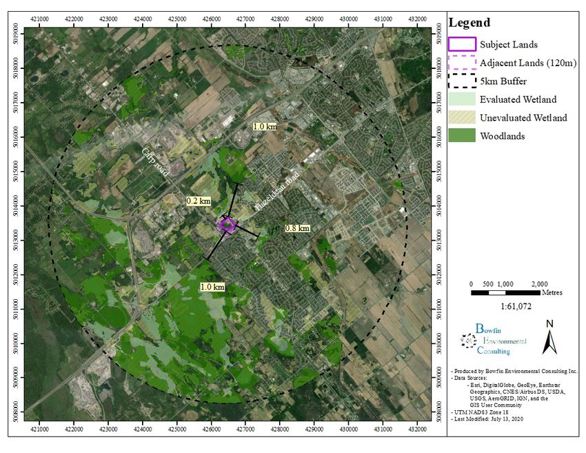
6171 Hazeldean Road                                                             EIS - TCR

SRANK DEFINITIONS
S1  Critically Imperiled in the nation or state/province because of extreme rarity (often 5 or
    fewer occurrences) or because of some factor(s) such as very steep declines making it
    especially vulnerable to extirpation from the state/province.
S2  Imperiled in the nation or state/province because of rarity due to very restricted range,
    very few populations (often 20 or fewer), steep declines, or other factors making it very
    vulnerable to extirpation from the nation or state/province.
S3  Vulnerable in the nation or state/province due to a restricted range, relatively few
    populations (often 80 or fewer), recent and widespread declines, or other factors making
    it vulnerable to extirpation.
S4  Apparently Secure; uncommon but not rare; some cause for long-term concern due to
    declines or other factors.
S5  Secure; Common, widespread, and abundant in the nation or state/province.
?   Inexact Numeric Rank—Denotes inexact numeric rank

SNR Unranked, Nation or state/province conservation status not yet assessed.
SU      Unrankable, Currently unrankable due to lack of information or due to substantially
conflicting information about status or trends.
SNA Not Applicable, A conservation status rank is not applicable because the species is not a
        suitable target for conservation activities.
S#S# Range Rank, A numeric range rank (e.g., S2S3) is used to indicate any range of
uncertainty about the status of the species or community. Ranges cannot skip more than one rank
(e.g., SU is used rather than S1S4).
S#B Breeding
S#N Non-Breeding

SARA STATUS DEFINITIONS
END Endangered: a wildlife species facing imminent extirpation or extinction.
THR Threatened: a wildlife species that is likely to become endangered if nothing is done to
     reverse the factors leading to its extirpation or extinction.
SC   Special Concern, a wildlife species that may become threatened or endangered because of
     a combination of biological characteristics and identified threats.

SARO STATUS DEFINITIONS
END Endangered: A species facing imminent extinction or extirpation in Ontario which is a
     candidate for regulation under Ontario's ESA.
THR Threatened: A species that is at risk of becoming endangered in Ontario if limiting factors
     are not reversed.
SC   Special concern: A species with characteristics that make it sensitive to human activities
     or natural events.

Bowfin Environmental Consulting Inc.                                                    3
July 21, 2020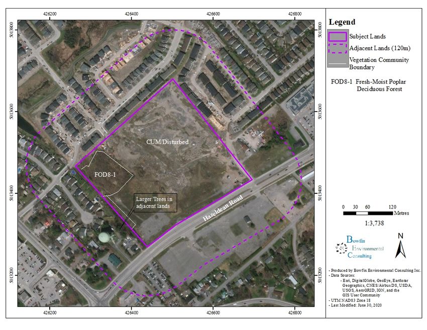
6171 Hazeldean Road                                                       EIS - TCR

Coefficient of Conservatism Ranking Criteria
0       Obligate to ruderal areas.
1      Occurs more frequently in ruderal areas than natural areas.
2      Facultative to ruderal and natural areas.
3       Occurs less frequent in ruderal areas than natural areas.
4      Occurs much more frequently in natural areas than ruderal areas.
5      Obligate to natural areas (quality of area is low).
6       Weak affinity to high-quality natural areas.
7       Moderate affinity to high-quality natural areas.
8      High affinity to high-quality natural areas.
9       Very high affinity to high-quality natural areas.
10      Obligate to high-quality natural areas.

Bowfin Environmental Consulting Inc.                                            4
July 21, 2020
6171 Hazeldean Road                                                                                                     EIS - TCR

Table of Contents
1.0              INTRODUCTION ..................................................................................................... 7
2.0              METHODS .............................................................................................................. 11
  2.1            Study Area ............................................................................................................... 11
  2.2            Background Review ................................................................................................ 11
  2.3            Field Studies ............................................................................................................ 11
        2.3.1 Description of Vegetation Communities and Flora Observations ........................... 11
        2.3.2 Butternut Inventory.................................................................................................. 12
        2.3.3 Incidental Fauna Observations ................................................................................ 13
        2.3.4 Tree Inventory ......................................................................................................... 13
3.0              RESULTS ................................................................................................................ 14
  3.1             Background Information......................................................................................... 14
        3.1.1 Location ................................................................................................................... 14
        3.1.2 Natural Heritage Features ........................................................................................ 14
  3.2            Vegetation Communities ......................................................................................... 18
  3.3            Incidental Observations of Fauna and Flora ............................................................ 24
4.0              EVALUATION OF NATURAL HERITAGE FEATURES ................................... 24
  4.1            Significant Woodlands ............................................................................................ 24
  4.2            Endangered and Threatened Species Discussion ..................................................... 24
        4.2.1 SAR Conclusions ..................................................................................................... 29
  4.3            Significant Wildlife Habitat..................................................................................... 33
  4.4            Natural Heritage Features Summary ....................................................................... 33
5.0              IMPACT ASSESSMENT........................................................................................ 34
  5.1            Project Summary ..................................................................................................... 34
  5.2            Assessment Methods ............................................................................................... 34
  5.3            Evaluation of Potential to Impact Natural Heritage Features .................................. 35
        5.3.1 Species at Risk ......................................................................................................... 35
        5.3.3 Other ........................................................................................................................ 37
6.0              TREE CONSERVATION AND PLANTING PLAN ............................................. 37
7.0              CONCLUSIONS AND RECOMMENDATION .................................................... 46
8.0              REFERENCES ........................................................................................................ 46

Bowfin Environmental Consulting Inc.                                                                                                5
July 21, 2020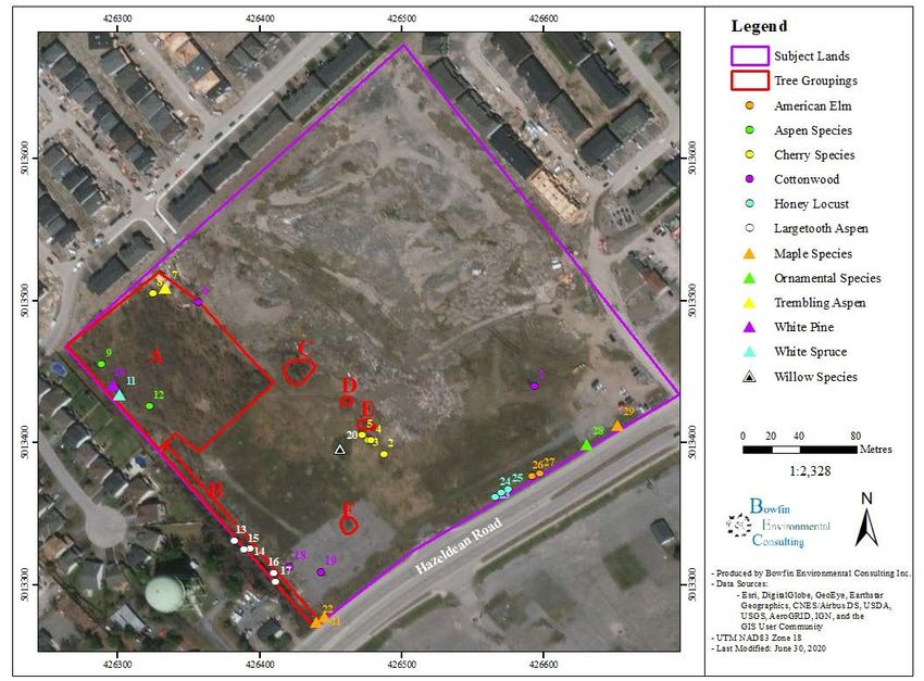
6171 Hazeldean Road                                                                                                      EIS - TCR

Appendix A: Tree Conservation Report ....................................................................................... 51

List of Figures
Figure 1: General Location of the Study Area ................................................................................ 9
Figure 2: Location of the Study Area ........................................................................................... 10
Figure 3: Location of Unevaluated and Evaluated Wetlands and Woodland taken from LIO ..... 16
Figure 4: Location of other Natural Heritage Features from LIO ................................................ 17
Figure 5: Vegetation Community Descriptions ............................................................................ 23
Figure 3: Location of Trees to be Removed ................................................................................. 55

List of Tables
Table 1: Summary of Available Background Information on the Identified Natural Features
(PSW, Woodlands, Valleylands, ANSIs, ESA, SWH, and Fish Habitat)..................................... 14
Table 2: Summary of Potential SAR ............................................................................................ 30
Table 3: Summary of Potential for Natural Heritage Features after Field Investigations ............ 33
Table 4      Summary of Impacts, Mitigation Measures and Residual Effects .......................... 39

List of Photographs
Photo 1: Looking west from the near the access road (June 26, 2020) ........................................ 18
Photo 2: Looking at the access road (June 26, 2020) ................................................................... 19
Photo 3: Looking east from near the northwest corner at the disturbed area and adjacent lands
(June 26, 2020).............................................................................................................................. 19
Photo 4: Looking west at one of the small copses (June 26, 2020) .............................................. 20
Photo 5: Looking south at the northwest side of the small FOD8-1 stand (June 26, 2020) ......... 21
Photo 6: Looking at the larger trees in the adjacent lands near water tower (June 26, 2020) ...... 22

Bowfin Environmental Consulting Inc.                                                                                                 6
July 21, 2020
6171 Hazeldean Road                                                                 EIS - TCR

1.0       INTRODUCTION

11654128 Canada Inc., hereafter referred to as the proponent, is proposing to build a residential
subdivision at 6171 Hazeldean Road, Stittsville, Ontario (Figure 1). It is in part of Lot 23,
Concession 12 in the City of Ottawa (formerly Goulbourn Township). The proposed subdivision
site includes almost 9 ha of lands that were previously cleared and now consist mostly of fill
(naturalizing to meadow habitat) and young deciduous forest. The site is surrounded by
developed lands on all sides. The development would be fully serviced.

During the pre-consultation, the City of Ottawa indicated that the client was to complete an
Environmental Impact Statement (EIS) along with a Tree Conservation Report (TCR).

Bowfin Environmental Consulting Inc. (Bowfin) was retained to complete the combined
EIS/TCR. As per the Official Plan (OP) of the City of Ottawa (2003), an EIS is required to
determine if significant natural features have been designated in or adjacent to the subject lands
followed by an assessment of the potential impacts to any identified natural environment from
the proposed development. The OP follows the guidelines set out in the Provincial Policy
Statement (PPS) in which there are several natural features and areas identified as needing
protection. These are:

      •   Significant habitat of Endangered and Threatened Species;
      •   Significant wetlands;
      •   Significant woodlands;
      •   Significant valleylands;
      •   Significant wildlife habitat;
      •   Significant Areas of Natural and Scientific Interest; and
      •   Fish habitat.

The City indicated that the EIS could be scoped to address significant woodlands, and the
potential for significant wildlife habitat and endangered and threatened species and their habitats.

The locations of known significant features along with other locally significant features
(identified as part of the City’s Natural Heritage System) are identified on OP schedules A, B, K
and L. Note that the presence/absence of habitat for endangered (END) or threatened (THR)
Species as well as some significant wildlife habitats (SWH) are not depicted on the OP
schedules. Their presence/absence must be determined based on the criteria in the OP or the
appropriate MNRF methodology [i.e. species-specific surveys, presence of preferred habitats and
the MNR’s Natural Heritage Reference Manual (OMNR, 2010)]. Where identified, the
boundaries of any significant features are noted and the potential for the proposed land

Bowfin Environmental Consulting Inc.                                                        7
July 21, 2020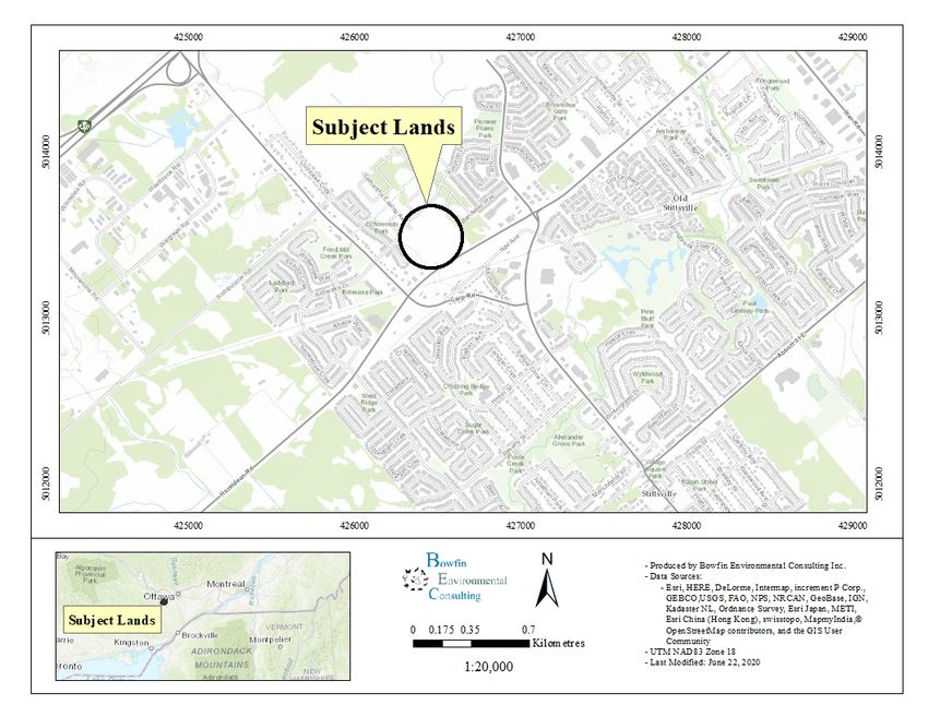
6171 Hazeldean Road                                                                EIS - TCR

development to cause negative impacts is assessed. For those features which may be negatively
impacted, mitigation measures and where appropriate compensation measures are recommended.

The following report includes an assessment of the natural environment habitats within the
subject lands and discusses the potential for negative impacts. The PPS states that a negative
impact signifies:

       “a) in regard to policy 2.2, degradation to the quality and quantity of water,
       sensitive surface water features and sensitive ground water features, and their
       related hydrologic functions, due to single, multiple or successive development or
       site alteration activities;
       c) in regard to other natural heritage features and areas, degradation that
       threatens the health and integrity of the natural features or ecological functions
       for which an area is identified due to single, multiple or successive development
       or site alteration activities.”

This EIS portion follows the City of Ottawa Environmental Impact Statement Guidelines (City of
Ottawa, 2012) and the TCR sections follow the City of Ottawa Tree Conservation Report
Guidelines (City of Ottawa, 2019).

The intention of the TCR is to determine what woody vegetation needs to be retained and
protected on site.

The field work for EIS was led by Michelle Lavictoire who has a Master of Science in Natural
Resource Sciences and over 23 years of experience in completing natural environment
assessments. The TCR field work was completed by Cody Fontaine, a Fish and Wildlife
Technologist with 10 years of experience.

The paragraphs below outline the methods, followed by a review of the available background
information and a description of the site’s existing conditions. This information is used to
evaluate the potential impacts to the features and to make recommendations in terms of the EIS
and TCR.

Bowfin Environmental Consulting Inc.                                                        8
July 21, 2020
6171 Hazeldean Road                            EIS - TCR

Figure 1: General Location of the Study Area

Bowfin Environmental Consulting Inc.                 9
July 21, 2020
6171 Hazeldean Road                    EIS - TCR

Figure 2: Location of the Study Area

Bowfin Environmental Consulting Inc.         10
July 21, 2020
6171 Hazeldean Road                                                               EIS - TCR

2.0    METHODS
Work undertaken for the completion of this project included a background review of existing
information and field investigations.

  2.1 Study Area
The study area (Figure 2) varied with the item being surveyed. For the most part, the OP calls
for an evaluation of the subject lands and the adjacent 120 m. The detailed field investigations,
and assessments were completed within the subject lands (area proposed to be developed).
These investigations also included general observations within the adjacent lands. The
background review and consideration for the potential for species at risk (SAR) included a larger
study area. The study area for each item is described in the methods or ESA discussion sections.

  2.2 Background Review
The background review began with preliminary mapping of the vegetation communities, in the
subject lands and the adjacent 120 m, as a desktop exercise. The search of databases and
available background data also included the adjacent ±5 km.

The background search of available records and consulting reports was made to gather
information on the known and potential occurrences of SAR within the project area. The
following web sources were reviewed during the background review: Natural Heritage
Information Centre (NHIC), species at risk in Ontario website, and Land Information Ontario
(LIO). In the City of Ottawa, natural heritage features are designated on Schedules A, B, K, and
L of the OP. As such these were reviewed along with the geoOttawa website. Citizen science
databases such as iNaturalist and Atlas of Breeding Birds of Ontario were also analysed.

  2.3 Field Studies

Following discussions with City of Ottawa, MECP and through a review of the imagery for the
site, it was determined that the field investigations would be limited to description of
communities, butternut inventory, incidental observations, and tree inventory. Avoidance and
mitigation measures have been put in place to eliminate impacts to other species relieving the
proponent of the need to complete additional surveys.

      2.3.1    Description of Vegetation Communities and Flora Observations
To assess the potential for SAR or their habitat, the vegetation communities within the subject
lands and the adjacent 120 m were described. Sufficient level of detail was collected to provide
general habitat descriptions and identify preferred habitats for various SAR and significant
wildlife habitat.

Bowfin Environmental Consulting Inc.                                                      11
July 21, 2020
6171 Hazeldean Road EIS - TCR
The field studies were completed by systematically travelling through the study area and by
ground truthing the results from the preliminary mapping exercise. Habitat descriptions were
based on the appropriate methodologies such as: Ontario Wetland Evaluation System, Southern
Manual (OWES) (OMNR, 2013a) for wetland habitats and the Ecological Land Classification
for Southern Ontario 1st approximation for terrestrial habitats (ELC) (Lee et al., 1998). Note that
OWES took precedent over the ELC where an OWES wetland community was present. The
OWES definition of wetland habitat is:
“Lands that are seasonally or permanently flooded by shallow water as well as
lands where the water table is close to the surface; in either case the presence of
abundant water has caused the formation of hydric soils and has favoured the
dominance of either hydrophytic or water tolerant plants”.
OWES defines the wetland boundary as the location where over 50% of the plant community
consists of upland species with the woody vegetation layer (trees and shrubs) taking precedence
over the herbaceous layer (OMNR, 2013a). Furthermore, the presence of large numbers of
obligate upland species requires an upland classification. Unless they contain a special feature or
function wetlands smaller than 0.5 ha were not delineated.
No delineation of community’s boundaries was completed for this work. All boundaries were
created using satellite imaging. Delineation of forests includes habitats classified as forest using
ELC (regardless of the age of the tree species). It also includes treed swamps, low shrub and tall
swamps using OWES when the cover provided by trees met the definitions of a forest under
ELC. Forest is defined in the ELC as communities where the tree species provide >60% cover
(regardless of the age of the individuals).
Plants that could not be identified in the field were collected for a more detailed examination in the
laboratory. Nomenclature used in this report follows the Southern Ontario Plant List (Bradley, 2009)
for both common and scientific names which are based on Newmaster et al. (1998). Authorities for
scientific names are given in Newmaster et al. (1998). Specific attention was paid to locating SAR or
species of conservation value (any S1-S3 species) listed as potentially occurring within the study area.
Any specimen observed was photographed and its coordinates were recorded on a GPS using NAD83.
2.3.2 Butternut Inventory
The Ontario government’s mandatory protocol for the assessment of butternuts was followed.
The assessment is referred to as a Butternut Health Assessment (BHA) and must be completed
by a Butternut Health Assessor certified by the Ministry of Environment, Conservation and Parks
(MECP). The first step is to search in and within 50 m of the subject lands. For this site, the subject
lands themselves, and the trees along Hazeldean Road were surveyed. The adjacent lands are separated
Bowfin Environmental Consulting Inc. 12
July 21, 20206171 Hazeldean Road EIS - TCR
from tall, wooden fences and are fully developed (residential) diminishing the potential for butternuts in
the adjacent lands. Any individuals noted would be marked with white spray paint and flagging tape
and numbered sequentially. Their UTMs, using a GPS unit set at NAD83, would be recorded and the
individual would be assessed according the BHA protocol by a qualified Butternut Health Assessor.
As will be noted further on, no butternuts were found.
2.3.3 Incidental Fauna Observations
During all visits, any wildlife observations were recorded. Incidental observations included
observations of an individual, its tracks, burrows, feces and/or kill sights.
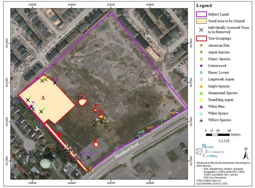
2.3.4 Tree Inventory
As part of the TCR, the individual trees were assessed and a description of the environmental
value of the trees within the site and their ecological function recorded. Information collected on
the individual trees included:
• Their location (UTM, NAD83);
• Identified to species for native specimens;
• Diameter at breast height (DBH);
• Presence/absence of Butternuts; and
• Health.
Where the density of trees with a DBH > 10 cm was high, they were grouped and described as a
whole.
This information including maps of the individual trees present and one that shows tree to be
removed is provided in the TCR which is found in Appendix A. The mitigation measures
recommended are embedded within this EIS to facilitate review.
Bowfin Environmental Consulting Inc. 13
July 21, 20206171 Hazeldean Road EIS - TCR
3.0 RESULTS
A summary of the results from the background review and site visits are provided in the
paragraphs below followed by a discussion on potential to impact natural heritage features.
3.1 Background Information
3.1.1 Location
The study area is situated at 6171 Hazeldean Road, in part of Lot 23, Concession 12 in the City
of Ottawa, former township of Goulbourn. The proposed subdivision includes approximately
9 ha. It is bordered by Hazeldean Road to the south and residential developments to the west
(along Lloydalex Crescent), north (Kimpton Drive) and east (Stittsville Main Street).
3.1.2 Natural Heritage Features
Schedule B of the OP indicates that the study area is designated as General Urban Area. There
are no natural features depicted on Schedules B, K, or L of the OP in the subject lands. The
adjacent lands show wetland/organic soils to the north and east and wooded area to the east but
much of this has already been developed (Figure 2). Though the geoOttawa site shows the
Stittsville Wetland Complex, a PSW, to be immediately adjacent to the site this area has been
developed into a subdivision. The nearest remaining portion of the PSW is about 200 m to the
north and the area between that remnant wetland and this site is fully developed. There are no
remaining wetlands within 120 m of this site. The wooded area in the eastern adjacent lands is6171 Hazeldean Road EIS - TCR
Present within Present within
Natural Heritage Present nearby
Subject Lands 120 m of Subject
Feature (±5 km)
Impact Lands
Habitats or species Blanding’s Turtles
designated by ESA No known occurrences >1 km to east and
(Provincial) west (iNaturalist)
None
(schedules show as There are wooded
wooded, but areas within 1 km to
geoOttawa mapping the north, west and
Significant Woodlands None
shows it is developed south and within
except for a small 2 km to the
treed area < 0.2 ha in southeast.
size)
Significant Valleylands No
Significant Wildlife
Potential is discussed in Section 4
Habitat (SWH)
Fish Habitat No
Sources of background information: OP (City of Ottawa), Google Satellite Imaging
Bowfin Environmental Consulting Inc. 15
July 21, 20206171 Hazeldean Road EIS - TCR Figure 3: Location of Unevaluated and Evaluated Wetlands and Woodland taken from LIO Bowfin Environmental Consulting Inc. 16 July 21, 2020
6171 Hazeldean Road                                              EIS - TCR

Figure 4: Location of other Natural Heritage Features from LIO

Bowfin Environmental Consulting Inc.                                   17
July 21, 2020
6171 Hazeldean Road                                                                EIS - TCR

  3.2 Vegetation Communities
The study area consisted primarily of cultural meadows (fallow fields) with inclusions of tree
groupings. These communities are depicted on Figure 5.

Cultural Meadows
The review of the various geoOttawa mapping and satellite images demonstrates that the site was
cleared between 1976 and 1999 and again between 2002 and 2005. Fill was present throughout
much of the site in 2017. This fill has mostly been levelled and some areas have been
naturalized by broadleaf, herbaceous meadow species. The most common species were bird’s-
foot trefoil, and white sweet clover. Other frequently encountered species were: black medick,
common plantain, cow vetch, smooth brome, wild carrot, ragweed, quack grass, sow thistle,
yellow rocket, campion bladder, foxtail barley, purple clover, white clover, chicory, viper’s
bugloss, common milkweed and other grasses.

              Photo 1: Looking west from the near the access road (June 26, 2020)

Bowfin Environmental Consulting Inc.                                                      18
July 21, 2020
6171 Hazeldean Road EIS - TCR
Photo 2: Looking at the access road (June 26, 2020)
Photo 3: Looking east from near the northwest corner at the disturbed area and adjacent lands
(June 26, 2020)
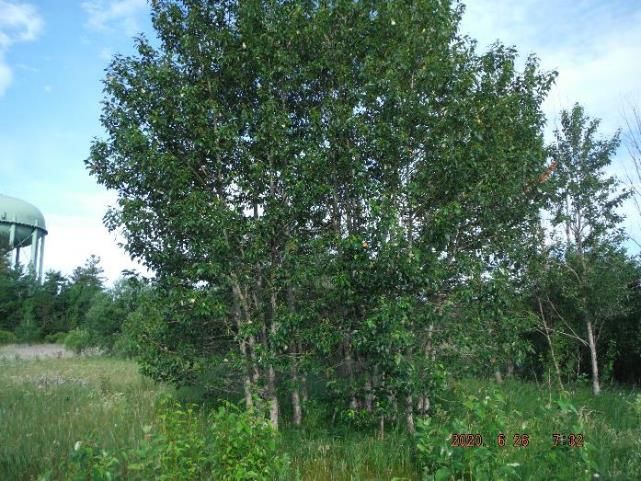
In the cultural meadow were a few small copses of balsam poplar. These inclusions were much
smaller than the 0.5 ha minimum size for vegetation community descriptions. In general, they
consisted of young [1-3 m tall; up to 10 cm in diameter-at-breast-height (dbh)] balsam poplars in
dense stands. The other vegetation included ground cover such as: grasses, smooth brome, wild
parsnip, campion bladder, bird’s-foot trefoil followed by common milkweed, quack grass, wild
Bowfin Environmental Consulting Inc. 19
July 21, 20206171 Hazeldean Road EIS - TCR
grape, wild carrot, cow vetch and common mullein. A few individual honeysuckles were also
present.
Photo 4: Looking west at one of the small copses (June 26, 2020)
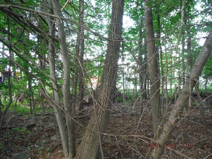
Deciduous Forest (Fresh-Moist Poplar Deciduous Forest Type)
The largest community of trees consisted of the deciduous forest in the northwest portion of the
site. This community was near 0.8 ha in size. It was heavily disturbed by trails, couches, and
previous clearings (as noted above). The community is less than 60 year old (based on the
review of geoOttawa mapping). The most applicable ELC community that matches this
disturbed area is that of a Fresh-Moist Poplar Deciduous Forest Type (FOD8-1). The canopy
was 3-5 m tall and provided up to 90% cover. The dominant species in this layer were balsam
poplar and trembling aspen followed by largetooth aspen and Bebb’s willow, common
buckthorn, and glossy buckthorn. There was no sub-canopy. The understory (0.5-1.0 m tall; 5-
15% cover) consisted of wild red raspberry and black raspberry followed by thimbleberry,
honeysuckle, trembling aspen, and American elm. The ground cover (20-90% cover) was
variable. More commonly noted species were poison ivy, cow vetch, late goldenrod, wild
parsnip, common milkweed. Spreading dogvane and white poplar (non-natives) were noted.
Bowfin Environmental Consulting Inc. 20
July 21, 20206171 Hazeldean Road EIS - TCR
Photo 5: Looking south at the northwest side of the small FOD8-1 stand (June 26, 2020)
Deciduous Windrow (adjacent lands)
In the adjacent lands, on the west border of the site, was a narrow well-treed area that was
disturbed by gardens, spoil piles, trails, and garden cuttings. There were a few larger trees on the
south side. A review of the geoOttawa images shows that only a small area near the water tower
have been present since 1976 but even these appeared to have been selectively harvested (the
2014 images shows only a couple of remaining trees). They were 8-14 m tall and provided full
canopy cover. The most common species were American basswood, ironwood, trembling aspen
followed by white pine, eastern white cedar, sugar maple and white birch.
Bowfin Environmental Consulting Inc. 21
July 21, 20206171 Hazeldean Road EIS - TCR Photo 6: Looking at the larger trees in the adjacent lands near water tower (June 26, 2020) Bowfin Environmental Consulting Inc. 22 July 21, 2020
6171 Hazeldean Road                           EIS - TCR

Figure 5: Vegetation Community Descriptions

Bowfin Environmental Consulting Inc.                23
July 21, 2020
6171 Hazeldean Road                                                                  EIS - TCR

  3.3 Incidental Observations of Fauna and Flora
During the June 26, 2020 site visit the following species were noted: American goldfish,
common grackle, northern cardinal, song sparrow, and American robin.

All plant species were common species for the area or non-natives (i.e. spreading dogvane,
honeysuckle, white poplar, common buckthorn). No remnants of rare vegetation communities or
large specimen trees were encountered. No SAR, including butternuts, were found.

4.0    EVALUATION OF NATURAL HERITAGE FEATURES

The following section looks at the identified or potential natural features and the results from the
field work to assess whether the feature is present and if present, whether it is significant based
on the OP, the Natural Heritage Reference Manual (OMNR, 2010), SWHTG (OMNR, 2000)
and/or the SWHCS; (OMNRF, 2015). As mentioned in Section 3.0, the only natural features
identified as significant on the OP schedules were wetlands and wooded areas. All of the
wetlands and the majority of the wooded areas within 120 m of the subject lands have been
developed. The potential for habitat of other endangered and threatened species and significant
wildlife habitat needed to be assessed in the field.

  4.1 Significant Woodlands
The Draft Significant Woodland: Guidelines for Identification, Evaluation and Impact
Assessment (not dated) indicates that all forests that are a minimum of 0.8 ha and at least 60
years old in the urban area are to be considered significant. As discussed above, the geoOttawa
mapping shows that the site was cleared between 1976 and 1999 and again between 2002 and
2005. The treed area on-site does not meet the minimum age.

  4.2 Endangered and Threatened Species Discussion
Terrestrial and wetland Endangered and Threatened Species at Risk, on private land, are
protected under provincial Endangered Species Act. It is noted that bird species protected under
the Species at Risk Act (SARA) are protected by the Migratory Bird Convention Act (MBCA) on
private lands. Mitigation measures to protect bird nests are included in Section 5.

Within this report, the acronym SAR refers to only Endangered or Threatened species. Special
Concern species do not receive protection from ESA or SARA and are discussed under
Significant Wildlife Habitat.

A list of potential SAR was compiled using various sources. The NHIC database provides
information available to the public on those SAR documented as occurring within the general
area. It should be noted that not all information for all species is available to the public.

Bowfin Environmental Consulting Inc.                                                         24
July 21, 2020
6171 Hazeldean Road                                                                 EIS - TCR

Furthermore, the absence of a recording does not necessarily indicate that the species is absent
from the area. The purpose of the NHIC database is to serve as a guide to help determine the
potential species which may occur within the project area. The background review also included
looking at the list of birds observed as part of the Atlas of Breeding Birds of Ontario (ABBO),
and any species from iNaturalist and any SAR species listed on these lists were considered as
potentially occurring within the subject lands. Added to this list were species that based on
personal experience, often occur within the general area. The resulting list includes 11 potential
SAR: 1 reptile (Blanding’s turtle), 6 birds (eastern whip-poor-will, chimney swift, bank swallow,
barn swallow, bobolink, and eastern meadowlark), four mammals (little brown myotis, northern
myotis, eastern small-footed myotis, and the tri-colored bat), and 1 plant (butternut) (Table 2).

NOTE: The ESA has now been transferred to the Ministry of Environment, Conservation and
Parks (MECP) (as of April 1, 2019). To date MECP has not changed the protocols or process for
assessing the potential to impact SAR. References to dealing with MNRF have been left in this
report as they were the responsible Ministry at the time of the field work.

         Reptiles

Blanding’s Turtle
Blanding’s turtle is associated with a variety of shallow slow aquatic habitats with submergent
and emergent plants. These turtles require basking sites located near the water such as exposed
rocks or partially submerged logs. The nesting sites are located within areas of loose substrates
varying from sand to cobblestone and may occur along roadways as far as 400 m away. Marsh
habitat is important for the juveniles for protection from predators. The species overwinters
within permanent water bodies (COSEWIC, 2005). This species can migrate far distances of up
to 6 km (OMNR, 2013c). Migration routes can include overland movement.

The habitat guidelines for Blanding’s turtle provide protection to the areas surrounding a nest, or
perceived nest area. The level of protection varies with the distance from the nest and has been
categorized by MNRF into three categories. These along with their protection level are:

     Category 1     Nest and the area within 30 m or Overwintering sites and the area within
                    30 m
     Category 2     The wetland complex (i.e., all suitable wetlands or waterbodies within 500 m
                    of each other) that extends up to 2 km from an occurrence, and the area
                    within 30 m around those suitable wetlands or waterbodies
     Category 3     Area between 30 m and 250 m around suitable wetlands/waterbodies
                    identified in Category 2, within 2 km of an occurrence

There is no aquatic or wetland features on-site. The adjacent lands and further are entirely
developed (residential, commercial development) with a heavily travelled road network. The
Bowfin Environmental Consulting Inc.                                                        25
July 21, 2020
6171 Hazeldean Road EIS - TCR
nearest wetland habitat is over 200 m to the north of Kimpton Drive and the nearest known
occurrences of this species are over 1.2 km away (to west and east). Given that the area is
heavily developed with a large amount of traffic, the potential for Blanding’s Turtles to use this
site for any purpose is limited. Other than general mitigation measures on education and best
practices during construction (discussed in Section 5), no mitigation measures are needed for this
species.
Birds
Through the background review, six species of birds were listed as potentially occurring: eastern
whip-poor-will, chimney swift, bank swallow, barn swallow, bobolink and eastern meadowlark.
No SAR were identified during the site investigations.
Eastern Whip-poor-will
The whip-poor-will is a well camouflaged species can be found in a multitude of forest types. Its
requirements consist of areas that are semi-open forests or sites with a closed forest intermixed
with other open habitats. It also needs some areas with little ground cover. Its minimum habitat
size requirement is 9 ha (COSEWIC, 2009b). The General Habitat Description for Eastern
Whip-poor-will (MNRF on-line document) indicates that the protected habitat for this species
includes three categories:
Category 1 known nests and 20 m of the nest
Category 2 the area between 20 m and 170 m from the nest or the approximate centre
of the defended territory
Category 3 the area of suitable habitat between 170 m and 500 m of the nest or
approximate centre of the defended territory
There are no 9 ha forest stands in or within 500 m of the site. This species is considered absent.
No mitigation measures are required.
Chimney Swift (Chaetura pelagica)
The chimney swift can often be found in developed areas and prefers to utilize structures such as
large (>50 cm diameter) trees or man-made structures such as chimneys for its nesting habitat
(COSEWIC, 2007a). Few large diameter trees (dbh > 50 cm) were identified during the tree
inventory (Appendix A) and no buildings/chimneys were present. No chimney swifts were
observed during any of the visits. This species is easily identified when present, it is very vocal
and forages often. This species is considered absent.
Bowfin Environmental Consulting Inc. 26
July 21, 20206171 Hazeldean Road EIS - TCR
Bank Swallow (Riparia riparia)
Bank swallows are known to nest in vertical banks including those along riverbanks, and sand
pits. Habitat for this species is absent. This species is considered absent.
Barn Swallow (Hirundo rustica)
The barn swallow can often be found nesting on man-made structures. No structures were
present on-site. This species is considered absent.
Bobolink (Dolichonyx oryzivorus)
This species is grassland-breeding-bird requiring a minimum of 4 ha of uncut meadow or field.
The Bobolink General Habitat Description (OMNRF, 2018) indicates that the protected habitat
for this species includes three categories:
Category 1 known nests and 10 m of the nest
Category 2 the area between 10 m and 60 m from the nest or the approximate centre of
the defended territory
Category 3 the area of continuous suitable habitat between 60 m and 300 m of the nest
or approximate centre of the defended territory
The site is naturalizing with broadleaf meadow species, not suitable for grassland breeding birds
such as this species. None were observed during the site investigations. This species is
considered absent.
Eastern Meadowlark
Like the bobolink, this is a grassland breeding birds requiring a minimum of 4 ha of uncut
meadow or field. The General Habitat Description for Eastern Meadowlark (OMNRF, 2018)
indicates that the protected habitat for this species includes three categories:
Category 1 known nests and 10 m of the nest
Category 2 the area between 10 m and 100 m from the nest or the approximate centre
of the defended territory
Category 3 the area of continuous suitable habitat between 100 m and 300 m of the
nest or approximate centre of the defended territory
The site is naturalizing with broadleaf meadow species, not suitable for grassland breeding birds
such as this species. None were observed during the site investigations. This species is
considered absent.
Bowfin Environmental Consulting Inc. 27
July 21, 20206171 Hazeldean Road EIS - TCR
Bats
The potential SAR bats within the general area are: little brown myotis, northern myotis, eastern
small-footed myotis and tri-colored bat. There are three types of habitats required by bats:
hibernation, maternity sites and day-roost sites. The latter is not considered critical habitat.
These four bats species prefer to hibernate in caves or mines. They can hibernate in buildings
but that is rare for these species (COSEWIC, 2013a). No caves or mines were present. No
buildings were present on-site.
The northern myotis tends to prefer larger expanses of older forests (late successional or primary
forests) and chose maternity sites in snags that are in the mid-stage of decay. They prefer habitat
with intact interior habitat and is shown to be negatively correlated with edge habitat (Menzel et
al., 2002; Broders et al., 2006; Yates et al., 2006; OMNRF, 2015). The small, young treed area
on-site is slightly less than 0.8 ha and young. As such, the preferred habitat was not present and
as such, this species’ maternity habitat is considered absent.
The recovery strategy for the eastern small-footed myotis indicates that the preferred maternity
habitat of this species consists of open rock habitats and that it rarely uses old buildings as
roosting/maternity sites (Humphrey, 2017). There was suitable maternity habitat present. Based
on this information, this species’ maternity sites are considered absent.
The Atlas of Mammals of Ontario (Dobbyn, 1994) suggests that the tri-colored bat is not present
within this part of Ontario however, the NatureServe mapping in the COSSARO (2015) includes
all of southeastern Ontario. The City of Ottawa summary of Species at Risk in Ottawa
(September 2019) indicates that only historical records of this species are available, there are no
recent sightings. Based on this information, this species is considered to have a very low
potential of occurring.
This leaves only the little brown myotis as potentially using the study area for maternity sites.
The SWHCS (OMNRF, 2015) indicates that consideration for maternity sites, for species that
utilise tree cavities, should be made when the vegetation community consists of a mature
deciduous or mixed forest with >10/ha of large trees (>25 cm DBH). MRNF guidelines for bat
maternity sites require a minimum of >10 snags (with a minimum DBH of 25 cm) / ha. The tree
inventory found that this site was small (< 1 ha of treed area) and that most trees were < 25 cm in
dbh. As such, it does not provide a high potential for bat maternity sites.
There remains the potential for various species to
the trees on-site for day-roosts. Mitigation measures will be included discussed further below.
Bowfin Environmental Consulting Inc. 28
July 21, 20206171 Hazeldean Road EIS - TCR
Plants
Butternuts
As discussed above, no butternuts were identified in or within 50 m of this site. This species is
considered absent. Note that butternut inventories are good for 2-years (in this case until June
26, 2022).
4.2.1 SAR Conclusions
Based on the habitat descriptions in the sections above and following numerous field
investigations from 2020, no confirmed SAR were present. While no other species was
confirmed, there remains the potential for a variety of bat species to use trees for day-roosts.
Bowfin Environmental Consulting Inc. 29
July 21, 20206171 Hazeldean Road EIS - TCR
Table 2: Summary of Potential SAR
SARA
ESA Reg. Schedule 1
Scientific
Common Name Preferred Habitat SRank 230/08 SARO List of References
Name
List Status Wildlife SAR
Status
REPTILES
S3, SNR
(Great
Emydoidea Shallow water, large marshes, shallow lakes or
Blanding's Turtle Lakes/St- THR THR COSEWIC 2005
blandingii similar such water bodies.
Lawrence
pop.)
BIRDS
Rock or sand barrens with scattered trees,
Eastern Whip- Antrostomus savannahs, old burns or other disturbed sites in a COSEWIC
S4B THR THR
poor-will vociferus state of early to mid-forest succession, or open 2009b
conifer plantations
Chaetura COSEWIC
Chimney Swift Cities, towns, villages, rural, and wooded areas. S4B, S4N THR THR
pelagica 2007a
Variety of forest types, most common in wet,
mixed deciduous-coniferous forest with a well-
developed shrub layer. It is often found in shrub
Riparia marshes, red maple stands, cedar stands, conifer COSEWIC
Bank Swallow S4B THR THR
riparia swamps dominated by black spruce and larch and 2013b
riparian woodlands along rivers and lakes. It is
also associated with ravines and steep brushy
slopes near these habitats
COSEWIC
Hirundo
Barn Swallow Open or semi-open lands: farms, field, marshes. S4B THR THR 2011a, Peterson
rustica
1980
Dolichonyx COSEWIC
Bobolink Primarily in forage crops, and grassland habitat. S4B THR THR
oryzivorus 2010b
Bowfin Environmental Consulting Inc. 30
July 21, 20206171 Hazeldean Road EIS - TCR
SARA
ESA Reg. Schedule 1
Scientific
Common Name Preferred Habitat SRank 230/08 SARO List of References
Name
List Status Wildlife SAR
Status
COSEWIC
Eastern Sturnella
Fields, meadows and prairies. S4B THR THR 2011b, Peterson
Meadowlark magna
1980
MAMMALS
Buildings, attics, roof crevices and loose bark on
Little Brown Myotis COSEWIC
trees or under bridges. Always roost near S4 END END
Myotis lucifugus 2013a
waterbodies.
COSEWIC
2013a, Broders
Myotis Older (late successional or primary forests) with
Northern Myotis S3 END END et al, 2006,
septentrionalis large interior habitat.
Menzel et al.
2002
Eastern Small- Found within deciduous or coniferous forests in
Myotis leibii S2, S3 END Eder 2002
footed Myotis hilly areas.
Perimyotis Prefers shrub habitat or open woodland near COSEWIC
Tri-colored Bat S3? END END
subflavus water. 2013a
PLANTS
Variety of sites, grows best on well-drained
Juglans COSEWIC
Butternut fertile soils in shallow valleys and on gradual S2? END END
cinerea 2003a
slopes
Status Updated September 2019
Bowfin Environmental Consulting Inc. 31
July 21, 20206171 Hazeldean Road EIS - TCR SRANK DEFINITIONS S2 Imperiled in the nation or state/province because of rarity due to very restricted range, very few populations (often 20 or fewer), steep declines, or other factors making it very vulnerable to extirpation from the nation or state/province. S3 Vulnerable in the nation or state/province due to a restricted range, relatively few populations (often 80 or fewer), recent and widespread declines, or other factors making it vulnerable to extirpation. S4 Apparently Secure, Uncommon but not rare; some cause for long-term concern due to declines or other factors. SAB Breeding accidental. ? Inexact Numeric Rank—Denotes inexact numeric rank S#B Breeding S#N Non-Breeding SARO STATUS DEFINITIONS END Endangered: A species facing imminent extinction or extirpation in Ontario which is a candidate for regulation under Ontario's ESA. THR Threatened: A species that is at risk of becoming endangered in Ontario if limiting factors are not reversed. SARA STATUS DEFINITIONS END Endangered, a wildlife species facing imminent extirpation or extinction. THR Threatened, a wildlife species that is likely to become endangered if nothing is done to reverse the factors leading to its extirpation or extinction. Bowfin Environmental Consulting Inc. 32 July 21, 2020
6171 Hazeldean Road                                                                  EIS - TCR

  4.3 Significant Wildlife Habitat

The PPS indicates that no development or site alteration is permitted within significant wildlife
habitat unless it has been demonstrated that there will be no negative impacts on the natural
feature or its ecological functions. It defines wildlife habitat as:

“Areas where plants, animals and other organisms live and find adequate amounts of
food, water, shelter and space needed to sustain their populations. Specific wildlife
habitat of concern may include areas where species concentrate at a vulnerable point in
their annual or life cycle; and areas which are important to migratory or non-migratory
species”

The OP schedules did not include any significant wildlife habitat present within the study area.
The vegetation communities were compared to MNRF’s SWHTG (2000) and its appendices and
the SWHCS (OMNRF, 2015). No significant wildlife habitats were observed.

  4.4 Natural Heritage Features Summary

The background review and site investigations determined that there were no confirmed
significant natural heritage features on-site and that the only potentially occurring habitat was for
bats (Table 3).

Table 3: Summary of Potential for Natural Heritage Features after Field Investigations

    Natural Heritage         Present within Subject      Present within 120 m of Subject
          Feature                Lands Impact                           Lands
       Provincially
   Significant Wetlands                No                                No
           (PSW)
   Areas of Natural and
     Scientific Interest               No                                No
          (ANSIs)
    Habitats or species
                            None confirmed. Potential for bat habitat remains and avoidance
    designated by ESA
                                            measures are included below.
        (Provincial)
  Significant Woodlands                                   No
  Significant Valleylands                                 No
  Significant Wildlife Habitat    No confirmed or potential
                                                                  None – fully developed.
             (SWH)                         SWH

Bowfin Environmental Consulting Inc.                                                         33
July 21, 2020
6171 Hazeldean Road EIS - TCR
Natural Heritage Present within Subject Present within 120 m of Subject
Feature Lands Impact Lands
Fish Habitat None
Sources of background information: LIO mapping, MNRF (email), Atlas of Breeding Birds of Ontario Website, OP
(City of Ottawa), Google Satellite Imaging
5.0 IMPACT ASSESSMENT
5.1 Project Summary
The proponent is proposing to build a residential subdivision at 6171 Hazeldean Road, Stittsville,
Ontario (Figure 1). The proposed subdivision includes approximately 9 ha. The development
would be fully serviced. Construction is anticipated to begin fall 2021 and to take 2-3 years to
fully construct.
The land use is designated as General Urban Area and while natural heritage features of
unevaluated wetlands and wooded areas were depicted in the background data, the site
investigations confirmed that none were present on or within 120 m of the site. A review of the
potential endangered and threatened species and their habitats and of significant wildlife habitat
identified the potential (low) for little brown myotis (bat) to be present. The woodland on-site
did not meet the age criteria to be considered significant.
Note that while not significant habitat, almost all birds in Ontario are protected by the Migratory
Bird Convention Act (MBCA) and/or Fish and Wildlife Conservation Act (FWCA). Mitigation
measures for these items are also included below for completeness.
5.2 Assessment Methods
The significance of the potential impacts to these natural heritage features can be measured using
four different criteria:
1. Area affected may be:
a. local in extent signifying that the impacts will be localized within the project area
b. regional signifying that the impacts may extend beyond the immediate project
area.
2. Nature of Impact:
a. negative or positive
b. direct or indirect
3. Duration of the impact may be rated as:
Bowfin Environmental Consulting Inc. 34
July 21, 20206171 Hazeldean Road EIS - TCR
a. short term (construction phase, 2-3 years)
b. medium term (4-5 years)
c. long term (>5 years).
d. permanent
4. Magnitude of the impact may be:
a. negligible signifying that the impact is not noticeable
b. minor signifying that the project’s impacts are perceivable and require mitigation
c. moderate signifying that the project’s impacts are perceivable and require
mitigation as well as monitoring and/or compensation
d. major signifying that the project’s impacts would destroy the environmental
component within the project area.
5.3 Evaluation of Potential to Impact Natural Heritage Features
5.3.1 Species at Risk
SAR that are listed as endangered or threatened under the provincial Endangered Species Act (all
species) or the federal Species at Risk Act (SARA) (only “fish” as defined under the Fisheries
Act in this case fish and mussel species) are protected in this study area. Together, provincially
and federally protected species are referred to as SAR. The only species considered as
potentially occurring are bats. Note that Blanding’s Turtle has also been included below since
this species could occur nearby.
Turtle (Blanding’s Turtle)
There is no suitable Blanding’s Turtle habitat on-site however, this species is known to occur
within 2 km of the site and there are wetlands (Stittsville Complex) within 0.2 km of the project
area. Because that wetland and this project’s site are surrounded by dense residential
neighborhoods, the area is not considered Category 3 habitat. But this species does like to
wander, and education of workers is considered recommended.
Mitigation Measures:
• Educate construction workers of the potential for Blanding’s Turtle to be present and that
this is a protected species from harm and injury under the provincial Endangered Species
Act.
• If a turtle is observed, then all work that may harm the individual must stop and the
worker should notify their supervisor. Try to take a photograph but do not chase the
turtle in order to do so.
• Turtles encountered on-site cannot be harmed or harassed.
• Turtles should be allowed to leave the area on their own.
Bowfin Environmental Consulting Inc. 35
July 21, 20206171 Hazeldean Road EIS - TCR
• It is also important that the individual be watched, from afar, to ensure that it does not
enter an area where it may come to harm.
• The supervisor should contact MECP (and if applicable the project biologist)
immediately.
Area Nature Duration Magnitude
Local Negative Short Unlikely to occur
Direct (very low potential
for species to be
present)
Bats
The SAR bats are: little brown myotis, northern myotis, eastern small-footed myotis and tri-
coloured. No hibernacula were found on site and the potential for maternity sites for all but little
brown myotis is considered absent. The potential for little brown myotis maternity habitat is
considered very low. Bats can also use any treed area for day-roots sites. The habitat for bats is
not limiting in the area.
Mitigation Measures:
• Educate contractors by informing them that most bats in Ontario are protected.
• Clearing of trees is to take place between October 1 and March 30. If this is not possible,
conduct exit survey (acoustic survey preferred) would be required prior to clearing. If a
bat is observed leaving the trees, then stop clearing vegetation and wait until after
September 30th for any additional tree clearing or obtain authorization from MECP.
Area Nature Duration Magnitude
Local Negative Permanent Term Low potential (young, small forest)
Direct (removal of tree)
Bowfin Environmental Consulting Inc. 36
July 21, 20206171 Hazeldean Road EIS - TCR
5.3.3 Other
As mentioned above, almost all birds in Ontario are protected by either MBCA or FWCA.
Potential Impacts and Mitigation Measures:
• Almost all breeding birds are protected under the MBCA and/or FWCA. The only
species not protected are: American crow, brown-headed cowbird, common grackle,
house sparrow, red-winged blackbird and starling. It is prohibited to destroy or disturb
an active nest of other birds, or to take or handle nests, eggs, or nestlings. In this part
of Ontario, the current standard nesting period is between April 12th to August 28th.
Outside of this timing window, it is considered unlikely that birds would be nesting.
Note, there are some birds (birds of prey, herons etc.) that do begin nesting earlier in
the year. It should also be noted, that if an active nest is present before or after the
above dates that it is still protected. These dates only serve as a guideline.
• There is the potential for ground nesters to occur within the subject lands once grading
activities occur should bare soil be left (i.e. killdeer). Perform regular walks of the cleared
areas looking for ground nesters. If any are present, the contact a biologist for guidance.
• Work during the daytime hours to prevent light disturbances.
• Ensure that all equipment have the appropriate mufflers to reduce noise disturbances.
6.0 TREE CONSERVATION AND PLANTING PLAN
A summary of individual trees and groupings along with Maps 1 and 2 as per the City’s TCR
requirements are provided in Appendix A. All trees situated on site will be removed.
Mitigation Measures for Trees to be Retained
• A permit for the removal of trees that are 10 cm or larger is required from the City of
Ottawa.
• The edge of the property, were not already fenced by neighbours, should be clearly
delineated on the site plans and in the field;
• All trees on-site will be removed. When clearing near trees on neighbouring lands,
mitigation measures to prevent harm to the root systems of trees adjacent to the proposed
works will be implemented to protect them from indirect harm:
o Sturdy fencing will be installed outside of the Critical Root Zone (CRZ) (defined
by the City as 10 x the DBH) of the trunk of the closest trees to the work area.
Bowfin Environmental Consulting Inc. 37
July 21, 20206171 Hazeldean Road EIS - TCR
o No grading or activities that may cause soil compaction (such as heavy machinery
and stockpiling of materials) will be allowed within the fenced area.
o Furthermore, no machinery maintenance or refueling or stockpiling is permitted
within 5 m of the outer edge of this fencing.
o If necessary, clearing of vegetation within the CRZ will be completed with hand
tools.
o Exhaust fumes from all equipment will be directed away from the canopy of the
trees to be retained.
o If roots of trees, on adjacent lands become exposed during site alterations, they
will be buried immediately with soil or covered with filter cloth or woodchips and
kept moist until the roots can be buried permanently.
o Any roots that must be cut will be cut cleanly to allow for healing.
• No signs, notices or posters should be attached to any trees;
• The removal of trees is to occur between October 1 and March 30. This is to avoid both
the active bat season and the breeding bird season (see timing and measures from above).
• Any landscape plans should include native species as much as possible various species
could be used.
Bowfin Environmental Consulting Inc. 38
July 21, 2020You can also read