A9 Keir Roundabout to West of Broxden Roundabout Corridor Study - DMRB Stage 1 Route Study Assessment Report - Transportation
←
→
Page content transcription
If your browser does not render page correctly, please read the page content below
Transportation   Transport Scotland   March 2013

A9 Keir Roundabout to West of Broxden
Roundabout Corridor Study - DMRB
Stage 1 Route Study Assessment Report
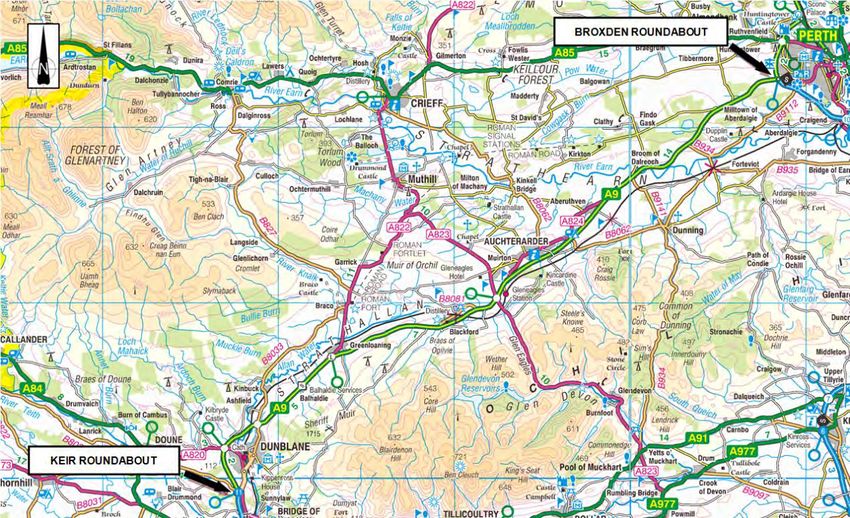
Table of Contents

1   Introduction ....................................................................................................................................................................... 4
    1.1     Introduction ............................................................................................................................................................ 4
    1.2     Background ........................................................................................................................................................... 4
    1.2.1   STPR 16 – A9 Upgrading from Dunblane to Inverness ......................................................................................... 4
    1.2.2   Infrastructure Investment Plan ............................................................................................................................... 4
    1.3     Study Objectives .................................................................................................................................................... 5
    1.3.1   National Transport Strategy ................................................................................................................................... 5
    1.3.2   STPR Intervention 16 Objectives ........................................................................................................................... 5
    1.3.3   Study Objectives .................................................................................................................................................... 5
    1.4     The Project Brief .................................................................................................................................................... 5

2   Existing Conditions........................................................................................................................................................... 6
    2.1     Introduction ............................................................................................................................................................ 6
    2.2     Background ........................................................................................................................................................... 6
    2.3     Route Description .................................................................................................................................................. 7
    2.4     Existing Traffic Conditions ..................................................................................................................................... 7
    2.4.1   Introduction ............................................................................................................................................................ 7
    2.4.2   Traffic Flows .......................................................................................................................................................... 7
    2.4.3   Congestion .......................................................................................................................................................... 15
    2.4.4   Safety .................................................................................................................................................................. 15
    2.4.5   Non-Motorised Users ........................................................................................................................................... 21
    2.4.6   Public Transport Network .................................................................................................................................... 22
    2.5     Future Conditions ................................................................................................................................................ 24
    2.6     Existing Road Network ........................................................................................................................................ 27
    2.6.1   Alignment............................................................................................................................................................. 27
    2.6.2   Junctions ............................................................................................................................................................. 27
    2.6.3   Roadside Features .............................................................................................................................................. 31
    2.6.4   Cross Section ...................................................................................................................................................... 32
    2.7     Other Potential/Proposed Improvements ............................................................................................................. 34
    2.8     Existing Environmental Conditions ...................................................................................................................... 34
    2.8.1   Air Quality ............................................................................................................................................................ 34
    2.8.2   Cultural Heritage .................................................................................................................................................. 34
    2.8.3   Landscape ........................................................................................................................................................... 35
    2.8.4   Ecology and Nature Conservation ....................................................................................................................... 37
    2.8.5   Geology & Soils ................................................................................................................................................... 38
    2.8.6   Noise and Vibration ............................................................................................................................................. 38
    2.8.7   Community and Private Assets ............................................................................................................................ 39
    2.8.8   Road Drainage and the Water Environment ........................................................................................................ 43

3   Route Strategies and Options ........................................................................................................................................ 48
    3.1    Introduction .......................................................................................................................................................... 48
    3.2    Grade Separation of Keir Roundabout................................................................................................................. 48
    3.3    Alternative Strategies for Grade Separation between Keir Roundabout and Broxden Roundabout .................... 48
    3.3.1  Collisions ............................................................................................................................................................. 49
    3.3.2  Strategy 1: Do Minimum ...................................................................................................................................... 49
    3.3.3  Dual Carriageway Categorisation ........................................................................................................................ 50
    3.3.4  Strategy 2: Roundabouts to facilitate u-turning traffic .......................................................................................... 50
    3.3.5  Strategy 3: Grade separation of junctions ............................................................................................................ 51
    3.4    Additional Options for Grade Separation ............................................................................................................. 58
    3.4.1  A824 Auchterarder/Loaninghead Interchange Link ............................................................................................. 58
    3.4.2  Shinafoot ............................................................................................................................................................. 59
    3.5    Other Minor Roads/Accesses .............................................................................................................................. 59
    3.6    Alternative Strategy Conclusions ......................................................................................................................... 59

4   Engineering Assessment ............................................................................................................................................... 60
4.1      Introduction .......................................................................................................................................................... 60
4.2      Locations considered for grade separation .......................................................................................................... 60
4.3      Keir Roundabout .................................................................................................................................................. 61
4.3.1    Site Description.................................................................................................................................................... 61
4.3.2    Topography and Land Use .................................................................................................................................. 62
4.3.3    Geomorphology ................................................................................................................................................... 62
4.3.4    Existing Ground Investigation .............................................................................................................................. 62
4.3.5    Other Features..................................................................................................................................................... 62
4.4      Greenloaning ....................................................................................................................................................... 63
4.4.1    Site Description.................................................................................................................................................... 63
4.4.2    Topography and Land Use .................................................................................................................................. 64
4.4.3    Geomorphology ................................................................................................................................................... 64
4.4.4    Existing Ground Investigation .............................................................................................................................. 64
4.4.5    Other Features..................................................................................................................................................... 64
4.5      Blackford.............................................................................................................................................................. 65
4.5.1    Site Description.................................................................................................................................................... 65
4.5.2    Topography and Land Use .................................................................................................................................. 66
4.5.3    Geomorphology ................................................................................................................................................... 66
4.5.4    Existing Ground Investigation .............................................................................................................................. 66
4.5.5    Other Features..................................................................................................................................................... 66
4.6      Aberuthven .......................................................................................................................................................... 67
4.6.1    Site Description.................................................................................................................................................... 67
4.6.2    Topography and Land Use .................................................................................................................................. 68
4.6.3    Geomorphology ................................................................................................................................................... 68
4.6.4    Existing Ground Investigation .............................................................................................................................. 68
4.6.5    Other Features..................................................................................................................................................... 68
4.7      Findo Gask .......................................................................................................................................................... 69
4.7.1    Site Description.................................................................................................................................................... 69
4.7.2    Topography and Land Use .................................................................................................................................. 70
4.7.3    Geomorphology ................................................................................................................................................... 70
4.7.4    Existing Ground Investigation .............................................................................................................................. 70
4.7.5    Other Features..................................................................................................................................................... 70
4.8      Forteviot............................................................................................................................................................... 71
4.8.1    Site Description.................................................................................................................................................... 71
4.8.2    Topography and land use .................................................................................................................................... 72
4.8.3    Geomorphology ................................................................................................................................................... 72
4.8.4    Existing Ground Investigation .............................................................................................................................. 72
4.9      Windyedge Cottages ........................................................................................................................................... 73
4.9.1    Site Description.................................................................................................................................................... 73
4.9.2    Topography and Land Use .................................................................................................................................. 74
4.9.3    Geomorphology ................................................................................................................................................... 74
4.9.4    Existing Ground Investigation .............................................................................................................................. 74
4.9.5    Other Features..................................................................................................................................................... 74
4.10     Minor Road and Access Treatment ..................................................................................................................... 75
4.11     Laybys ................................................................................................................................................................. 75
4.12     Use Of Existing Grade Separated Junctions And Any Other Planned Improvements ......................................... 76
4.12.1   Gleneagles Station Link Road ............................................................................................................................. 76
4.12.2   Loaninghead Interchange and A824 Junction .................................................................................................... 77
4.12.3   Shinafoot Junction ............................................................................................................................................... 77
4.12.4   Proposals to the West of Broxden Roundabout ................................................................................................... 77
4.13     Other Potential Route Improvements................................................................................................................... 77
4.13.1   Provision of Hard Strips ....................................................................................................................................... 77
4.13.2   Improvements to Existing Merge/Diverge ............................................................................................................ 78
4.13.3   Opportunities to facilitate NMUs .......................................................................................................................... 78
4.13.4   Improvements to Access/Egress at Services ....................................................................................................... 78
4.14        Public Utilities ...................................................................................................................................................... 78
            4.14.1      British Telecom .................................................................................................................................................... 78
            4.14.2      Cable & Wireless ................................................................................................................................................. 79
            4.14.3      National Grid ........................................................................................................................................................ 79
            4.14.4      Scotia Gas Networks ........................................................................................................................................... 79
            4.14.5      Scottish and Southern Energy ............................................................................................................................. 79
            4.14.6      Scottish Water ..................................................................................................................................................... 79
            4.14.7      Virgin Media ......................................................................................................................................................... 80
            4.15        Existing Road Pavement and Structures ............................................................................................................. 80
            4.16        Flooding ............................................................................................................................................................... 80

5           Environmental Assessment ........................................................................................................................................... 81
            5.1    Introduction .......................................................................................................................................................... 81
            5.2    Air Quality ............................................................................................................................................................ 81
            5.3    Cultural Heritage .................................................................................................................................................. 81
            5.4    Landscape Effects ............................................................................................................................................... 81
            5.5    Ecology & Nature Conservation ........................................................................................................................... 82
            5.6    Geology & Soils ................................................................................................................................................... 82
            5.7    Materials .............................................................................................................................................................. 82
            5.8    Noise & Vibration ................................................................................................................................................. 83
            5.9    Effects on All Travellers ....................................................................................................................................... 83
            5.10   Community & Private Assets ............................................................................................................................... 84
            5.11   Road Drainage and the Water Environment ........................................................................................................ 84
            5.12   Consideration of Cumulative Effects .................................................................................................................... 84

6           Traffic & Economic Assessment ................................................................................................................................... 85
            6.1      Introduction .......................................................................................................................................................... 85
            6.2      Economics ........................................................................................................................................................... 85
            6.2.1    Elements of the Assessment ............................................................................................................................... 85
            6.2.2    The NESA Analysis ............................................................................................................................................. 87
            6.2.3    NESA Inputs ........................................................................................................................................................ 87
            6.2.4    Transport Economic Efficiency Results ............................................................................................................... 87
            6.2.5    Impacts on Public Accounts ................................................................................................................................. 88
            6.2.6    Transport Economic Efficiency for Consumer Users ........................................................................................... 88
            6.2.7    Transport Economic Efficiency for Business Users and Transport Providers ...................................................... 88
            6.2.8    Reliability ............................................................................................................................................................. 88
            6.2.9    Wider Economic Impacts ..................................................................................................................................... 89
            6.3      Summary of Economy for Test Secnario ............................................................................................................. 89
            6.4      Summary of Economic Assessment .................................................................................................................... 89

7           Conclusions & Recommendations ................................................................................................................................ 91
            7.1    Summary ............................................................................................................................................................. 91
            7.2    Recommendations ............................................................................................................................................... 92

Appendix 1 – Existing Road Features.............................................................................................................................................94
Appendix 2 – Plan indicating sections of sub-standard geometry ...................................................................................................95
Appendix 3 – Junction Geometry Review Schedule .......................................................................................................................96
Appendix 4 - List of Horse Crossing Points on the A9 between Keir Roundabout and Broxden Roundabout ................................97
Appendix 5 – Letter from CTC Scotland regarding cycling on A9 between Keir Roundabout and Broxden Roundabout ...............99
Appendix 6 –Plan indicating Edge of Pavement Details ...............................................................................................................100
Appendix 7 – Junction Flow Diagram ...........................................................................................................................................101
Appendix 8 - Geological Plans ......................................................................................................................................................102
Appendix 9 – Indicative Flood Maps .............................................................................................................................................103

Table 1 - Breakdown of Road Collisions from 2007 to 2011, A9 (Keir to West of Broxden (Perth))................................................15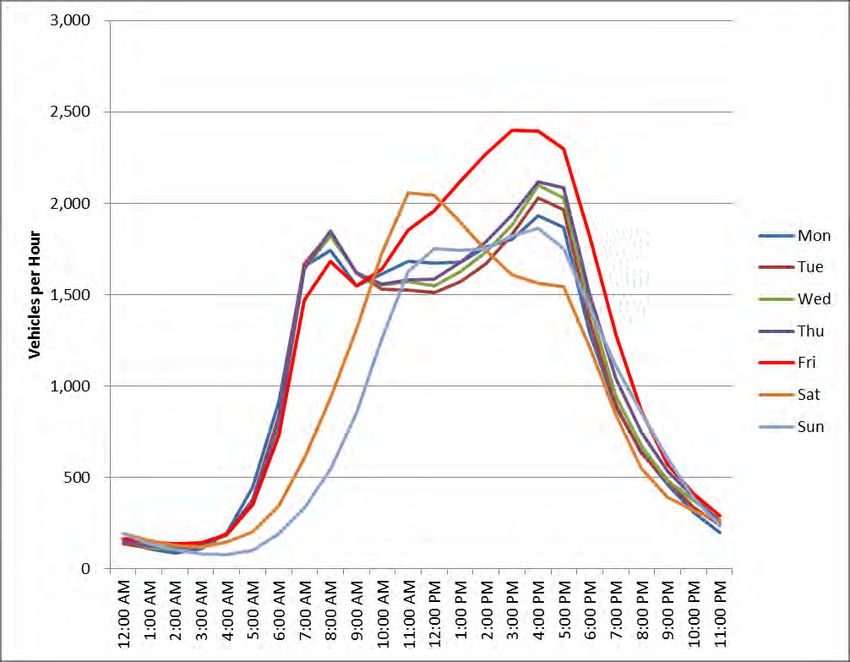
Table 2 - Junction Type/Proximity in the Instance of a Collision from 2007 to 2011, A9 (Keir to West of Broxden (Perth)) ...........16
Table 3 - Breakdown of the Total Number of Collisions by Location and Severity for the Period 2007 to 2011, A9 (Keir to West of
        Broxden (Perth)) ................................................................................................................................................................17
Table 4 - Comparison of Road Collisions / Casualty Totals, A9 (Keir to West of Broxden (Perth)) ................................................18
Table 5 - Summary of Road Collision Rates & Costs .....................................................................................................................19
Table 6 - Results of the Initial Analysis of the A9 (Keir to Broxden) Speed Limit Review ...............................................................20
Table 7 - Gleneagles Rail Station Survey – Pedestrian Movements...............................................................................................21
Table 8 - Rail Services Overview ....................................................................................................................................................24
Table 9 - Stirling /Perth & Kinross Local Development Plans - Key A9 Corridor Settlements .........................................................26
Table 10 - Summary of Existing Junctions on the A9 from Keir Roundabout to West of Broxden Roundabout ..............................28
Table 11 - Geometric Standards for Side Road Junctions ..............................................................................................................30
Table 12 - Junctions with sub-standard geometric features ............................................................................................................30
Table 13 - Service Area junctions with sub-standard geometric features .......................................................................................31
Table 14 – Review of route edge details.........................................................................................................................................33
Table 15 - Heritage Sites Summary ................................................................................................................................................35
Table 16 - Settlements on the A9 between Keir and Broxden ........................................................................................................41
Table 17 - Schedule of Properties with Direct Access to A9 ...........................................................................................................43
Table 18 - Other Surface Water Bodies Within the Study Area ......................................................................................................46
Table 19 - Excerpt from Table 4 of TD9/93 of the DMRB: Recommended Rural Road Layouts ....................................................50
Table 20 - Summary of Existing Junctions on the A9 - Keir Roundabout to West of Broxden ........................................................51
Table 21 – A9 Northbound side road traffic flows in excess of 500 AADT for an assumed design year of 2040 ............................55
Table 22 – A9 Southbound side road traffic flows in excess of 500 AADT for an assumed design year of 2040 ...........................55
Table 23 - Junction Location Assessment ......................................................................................................................................58
Table 24 - Estimated Costs (Q4, 2012 Prices) [excluding Optimism Bias] .....................................................................................86
Table 25 - Detailed Transport Economic Efficiency (TEE) Results .................................................................................................88
Table 26 - Economic Appraisal of Test Scenario ............................................................................................................................89

Figure 1 - Existing Road Network - Keir Roundabout to Broxden Roundabout ................................................................................6
Figure 2 - Scottish Trunk Road Database Count Sites on the A9 Corridor (Keir – Broxden) – Annual Average Daily Traffic Flow ..8
Figure 3 - A9 Dunblane Bypass (South) - Monthly Flow Profile over Time (JTC00012, 2003-2011) ................................................9
Figure 4 - A9 Dunblane Bypass (South) - Annual Average Weekday Traffic Profile (JTC00012, 2012) .........................................10
Figure 5 - A9 Dunblane Bypass (South) - Annual Average Weekday HGV Traffic Profile (JTC00012, 2012)33 ............................11
Figure 6 - A9 Dunblane Bypass (South) - Proportion of HGVs to All Traffic by Hour of the Day (2012) (JTC00012) .....................12
Figure 7 - A9 Broxden to Keir Roundabout – Differences in Traffic Flow........................................................................................13
Figure 8 - A9 West of Broxden - Annual Average Weekday Traffic Profile (JTC00568, 2012) .......................................................14
Figure 9 - Summary of Road Collisions / Casualty Totals, A9 (Keir to West of Broxden (Perth)) ...................................................18
Figure 10 – Local Bus Service Routes............................................................................................................................................23
Figure 11 - Forecast Traffic Growth to 2032 (Blackford) (Vehicles per Day) ..................................................................................25
Figure 12 - Location of A Class and B Class road junctions with the A9 ........................................................................................53
Figure 13 - Existing Road Layout at Keir Roundabout ....................................................................................................................61
Figure 14 - Existing Road Layout at Greenloaning .........................................................................................................................63
Figure 15 - Existing Road Layout at Blackford ................................................................................................................................65
Figure 16 - Existing Road Layout at Aberuthven ............................................................................................................................67
Figure 17 - Existing Road Layout at Findo Gask/Dunning Junction ................................................................................................69
Figure 18 - Existing Road Layout at Findo Gask/Dunning Junction ................................................................................................71
Figure 19 - Existing Road Layout at Windyedge Cottages .............................................................................................................73
Figure 20 - Existing Layby Locations ..............................................................................................................................................76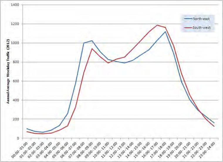
AECOM           A9 Keir Roundabout to West of Broxden Roundabout Corridor Study - DMRB Stage 1 Route Study Assessment Report        4

Capabilities on project:
Transportation

1          Introduction

1.1     Introduction
AECOM has been appointed by Transport Scotland to undertake a study of the A9 trunk road between Keir Roundabout and
Luncarty to allow Scottish Ministers to be better informed on future programming of work on this section of the A9.

This report summarises the findings of a Design Manual for Roads and Bridges (DMRB) Stage 1 Scheme Assessment for the A9
route between Keir Roundabout and west of Broxden Roundabout. The assessment has been carried out in accordance with
DMRB TD 37/93 and as such only a broad assessment of the engineering issues has been made at this stage.

1.2       Background
In 2008 Transport Scotland published their Strategic Transport Projects Review (STPR) which set out the transport investment
priorities for the Scottish Government's over the next 20 years.

This review identified recommendations that contributed most effectively towards the Government's Purpose of increased
sustainable economic growth. Means of potentially addressing transport issues were appraised to ensure that the Government's
priorities of a Wealthier and Fairer, Healthier, Safer and Stronger, Smarter and Greener Scotland would be met and that
investment was targeted on those recommendations that most effectively support improving Scotland’s sustainable economic
development.

The STPR supports the delivery of the three strategic outcomes identified in the National Transport Strategy:
-   Improving journey times and connections;
-   Reducing emissions; and
-   Improving quality, accessibility and affordability.

Twenty route corridors were assessed under STPR to identify strategic transport issues and two of the route corridors correlate
directly with this commission. These are Corridor 6 – Inverness to Perth and Corridor 9 – Glasgow to Perth.

Specific objectives were identified for each corridor, urban network and strategic node (of which Perth is one) and subsequently,
twenty-nine interventions were determined to address these including STPR 16 – A9 Upgrading from Dunblane to Perth.
1.2.1   STPR 16 – A9 Upgrading from Dunblane to Inverness
STPR 16 confirmed the Scottish Government’s commitment to the dualling of the A9 between Dunblane and Inverness, and
provided further detail on additional interventions for wider improvements to this section of the A9.

It acknowledged that many of the collisions on the A9 have occurred at the at-grade junctions; and that removal of these would
significantly reduce the severity of collisions on this route.

It further acknowledged that grade separation of Keir Roundabout, Broxden Roundabout, and Inveralmond Roundabout would
remove congestion at these locations contributing to reduce journey times, reliability and improved road safety.

The proposed route improvements, including the provision of a consistent carriageway standard along the A9, are expected to
significantly contribute towards the Scottish Government’s Purpose of increasing sustainable economic growth.

Proposed improvements included the following specific intervention measures:
-   Grade Separation of all junctions on the A9 from (and including) Keir Roundabout to south of Broxden Roundabout;
-   Grade Separation of Broxden Roundabout and Inveralmond Roundabout at Perth.

1.2.2  Infrastructure Investment Plan
The Scottish Government’s Infrastructure Investment Plan (IIP), published in December 2011, reiterated the Scottish
Government’s commitment to improve the A9 between Dunblane and Inverness.
AECOM A9 Keir Roundabout to West of Broxden Roundabout Corridor Study - DMRB Stage 1 Route Study Assessment Report 5
Capabilities on project:
Transportation
At the time of publication, expenditure for the A9 improvements between Dunblane and Inverness was predicted to be in the
order of £1.5bn to £3bn with scheme delivery between 2015 and 2030. It was anticipated that the costs and timescale for
delivery will be revisited and firmed up in future spending reviews.
The dualling of the A9 from Perth to Inverness is being taken forward separately by Transport Scotland and is not considered in
this report.
1.3 Study Objectives
1.3.1 National Transport Strategy
The National Transport Strategy sets out three Key Strategic Outcomes for transport:
- Improving journey times and connections, to tackle congestion and the lack of integration and communications in transport
that impact on the potential for continued and economic growth;
- Reducing emissions, to tackle the issue of climate change, air quality and health improvement; and
- Improving quality, accessibility and affordability, to give people a choice of public transport, where availability means better
quality transport services and value for money or an alternative to the car.
The STPR established the following objectives Intervention 16 - A9 Upgrading from Dunblane to Inverness.
1.3.2 STPR Intervention 16 Objectives
- Promote journey time reductions between Inverness and the Central Belt;
- Improve the operational effectiveness of the A9; and
- Reduce the severity of collisions and address driver frustration.
1.3.3 Study Objectives
The National Transport Strategy Objectives and STPR Intervention Objectives have been used to establish specific Study
Objectives for this element of the commission. These are as follows:
- Make improvements to tackle congestion and support the promotion of journey times reductions on this section of the A9,
particularly through Keir Roundabout;
- Reduce collision severity and the number of collisions on the A9 between Keir Roundabout and west of Broxden Roundabout.
1.4 The Project Brief
This DMRB Stage 1 Route Study Assessment forms one part of a wider commission considering the A9 between Keir
Roundabout and Luncarty. The main work packages as outlined in the brief comprise:
- STAG Appraisal assessing the road issues around Perth;
- DMRB Stage 1 Route Study Assessment Report considering the A9 from Keir Roundabout to west of Broxden Roundabout;
and
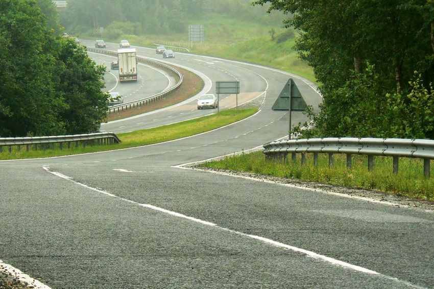
- DMRB Stage 1 Environmental Assessment.AECOM A9 Keir Roundabout to West of Broxden Roundabout Corridor Study - DMRB Stage 1 Route Study Assessment Report 6 Capabilities on project: Transportation 2 Existing Conditions 2.1 Introduction The A9 forms the main road link between the Central Belt of Scotland and Inverness. The route between Keir Roundabout, south of Dunblane, and Luncarty, just north of Perth is dual carriageway for its full length and is the longest single section of dual carriageway on the A9 road. Despite this, the route experiences problems arising from congestion during peak traffic hours; a poor collision history; unreliable journey times and operational difficulties particularly during the winter months. This DMRB Stage 1 Route Study Assessment Report considers improvements to the route between Keir Roundabout and to the west of Broxden Roundabout (See Figure 1 below), 2.2 Background This section of the A9 carries over 20,000 vehicles a day and national speed limits apply throughout the study length. The standard of junction along the route is variable with a mixture of grade separated and at grade junctions serving both public and private roads, as well as farm and residential accesses. Consequently there is conflict between high speed trunk road traffic and local traffic. Within this section of the A9, land uses are predominantly rural, with some areas being designated for commercial woodland, arable farmland and pasture land. This can result in agricultural/forestry vehicles and machinery coming into conflict with high speed trunk road traffic. Figure 1 - Existing Road Network - Keir Roundabout to Broxden Roundabout
AECOM           A9 Keir Roundabout to West of Broxden Roundabout Corridor Study - DMRB Stage 1 Route Study Assessment Report         7

Capabilities on project:
Transportation

2.3      Route Description
From Keir Roundabout the road leads north west, up a gradual incline towards the A820 grade separated junction before
sweeping north east, passing just north of Dunblane. The A9 crosses over the Auchinlay underpass, the Highland Mainline
railway and Annan Water in relatively quick succession before passing under the B8033 overbridge.

The road straightens toward Greenloaning, passing under overhead cables and over various watercourses which have been
culverted under the road. A pedestrian walkway on the near side of the northbound carriageway extends from the B8033 grade
separated junction to the Balhaldie Services. Balhaldie services, which includes a petrol filling station currently operated by Shell,
and a vacant road side restaurant once operated by Little Chef, is located approximately half way between Dunblane and
Greenloaning on the southbound carriageway.

By-passing just south of Greenloaning, the A9 passes under a single lane overbridge which serves south bound traffic heading
south on the A9 from Greenloaning and beyond. Between Greenloaning and Blackford, the road passes through areas of arable
and pasture land as well as passing over various watercourses which have been culverted under the dual carriageway.

The road continues past Blackford, passing over Annan Water and the Highland Mainline railway, and just past Loaninghead
petrol filling station where it passes under the A823 Loaninghead Interchange. The A9 bypasses Gleneagles and Auchterarder to
the south, again crossing over a number of minor watercourses. Two significant structures cross the A9 along the Auchterarder
bypass section of the A9, namely the Abbey Road overpass and the Shinafoot underpass.

Continuing in a north easterly direction, the road leads to a large bridge structure over the River Earn. It then climbs the Cairney
Braes, a long incline for approximately 2 miles, within large sections of cutting where exposed rock can be observed. The terrain
levels out and the A9 passes through a mixture of woodland and agricultural land before arriving at the Broxden Roundabout, the
northern end of the study corridor.

Plans showing the existing road layout and the location of existing road features are contained in Appendix 1.

2.4        Existing Traffic Conditions
2.4.1   Introduction
The study corridor connects the town of Dunblane (population 8,900) with the city of Perth (population 48,000). The principal
settlements between Dunblane and Perth (all located on the northern side of the A9) are:
-   Greenloaning (population 330);
-   Blackford (population 740; and home to Highland Spring and the Tullibardine distillery);
-   Auchterarder (population 4,200; including Gleneagles Hotel and golf courses); and
-   Aberuthven (population 390).

With the exception of the above settlements, the road corridor is generally sparsely populated.
2.4.2      Traffic Flows
2.4.2.1 A9 Keir – Broxden Traffic Flows
There are a number of automatic traffic count sites located along the route from Keir to Broxden. The locations of these are
shown in Figure 2, together with the Annual Average Daily Traffic (AADT) flows of the counters located at the Dunblane Bypass,
Blackford, and west of the Broxden Roundabout.
AECOM           A9 Keir Roundabout to West of Broxden Roundabout Corridor Study - DMRB Stage 1 Route Study Assessment Report   8

Capabilities on project:
Transportation

Figure 2 - Scottish Trunk Road Database Count Sites on the A9 Corridor (Keir – Broxden) – Annual Average Daily Traffic Flow

A summary of the main points regarding traffic flow on the corridor are shown below in the accompanying figures.
AECOM           A9 Keir Roundabout to West of Broxden Roundabout Corridor Study - DMRB Stage 1 Route Study Assessment Report     9

Capabilities on project:
Transportation

Figure 3 - A9 Dunblane Bypass (South) - Monthly Flow Profile over Time (JTC00012, 2003-2011)

Traffic flow along the route varies throughout the year and over time. Figure 3 (for the A9 Dunblane Bypass) is typical of the
pattern for other sites along the route. The main points of note are that:
-   Strong seasonality patterns exist along the corridor, where summer flows along the route are between 2,000 and 5,000
    vehicles higher per day than compared with during the winter months;
-   There is a small peak observed around the Easter holiday period;
-   The lowest flows observed in the last eight years have been observed in the winters of 2010/11 and 2011/12; and
-   Prior to 2008, there was a general upward trend in traffic using the route year on year. Following a short period of
    stabilisation, flows have been on a downward trend since 2008.
AECOM A9 Keir Roundabout to West of Broxden Roundabout Corridor Study - DMRB Stage 1 Route Study Assessment Report 10 Capabilities on project: Transportation Figure 4 - A9 Dunblane Bypass (South) - Annual Average Weekday Traffic Profile (JTC00012, 2012) Figure 4 shows that the morning peak traffic is heaviest in the north-eastbound direction but with the difference between the south-westbound flow only around 100 vehicles per day. In the evening peak the south-westbound direction is busier with the peak occurring between 16:00 and 17:00 instead of the more traditional 17:00-18:00 hour. This pattern is typical of the daily traffic flows on the A9. Nearer to Perth, the flow is typically tidal toward Perth in the morning and from Perth in the evening peak in a south-westerly direction. 2.4.2.2 Traffic Composition HGVs using the A9 are a key component in the movement and shipment of goods from the Central Belt to Inverness, the far North and North East Scotland. In the opposite direction goods such as timber, fresh fish and whisky are being transported south.
AECOM           A9 Keir Roundabout to West of Broxden Roundabout Corridor Study - DMRB Stage 1 Route Study Assessment Report   11

Capabilities on project:
Transportation

Figure 5 - A9 Dunblane Bypass (South) - Annual Average Weekday HGV Traffic Profile (JTC00012, 2012)33

The profile of hourly Heavy Goods Vehicles (HGV) movements on this section of the A9 shows that the flow is tidal. It peaks at
almost 250 HGVs in the north-eastbound flow between 07:00 and 08:00, with a slightly lower peak of just over 200 HGVs in the
south-westbound flow between 16:00 and 17:00 (as shown above). This confirms the use of the route to supply locations such as
Perth, Dundee, Aberdeen and Inverness from Central Belt locations.
AECOM           A9 Keir Roundabout to West of Broxden Roundabout Corridor Study - DMRB Stage 1 Route Study Assessment Report    12

Capabilities on project:
Transportation

Figure 6 - A9 Dunblane Bypass (South) - Proportion of HGVs to All Traffic by Hour of the Day (2012) (JTC00012)

Figure 6 shows the typical weekday profile of HGVs to all traffic. Notably, between the hours of 00:00 and 06:00, HGVs comprise
between 30% and 60% of the total traffic flow and even through the busiest parts of the day, between 10% and 20% of the total
flow. Again, the profile demonstrates that the flow is tidal.

Due to the nature of the land along the route corridor, and particularly at the section south of Greenloaning, the conflict with
agricultural vehicles is particularly prevalent on the A9. An Accident Analysis Report report written by BEAR, the operator
responsible for this section of the A9, in November 2012 noted the prolific number of farm and field accesses within this area. On
the section between Keir Roundabout and the Greenloaning junction, 6% of collisions involved an agricultural vehicle compared
with 2% over the whole of the North East Trunk Road Network. The report has recommended remedial measures to highlight the
potential presence of agricultural vehicles.
2.4.2.3 Comparison of Corridor Flows
As can be seen from Figure 7 below, the A9 from Broxden to the Auchterarder bypass carries around 24,000 vpd with a peak
Average Daily Weekday Traffic (ADWT) of 29,000 vpd. Along the Auchterarder and Blackford bypasses, the AADT flows fall
slightly to 22,000 vpd before rising to 28,000 vpd south of Greenloaning. From Greenloaning to Dunblane, the AADT is 28,000
vpd with a peak ADWT of 32,000 vpd.
AECOM                               A9 Keir Roundabout to West of Broxden Roundabout Corridor Study - DMRB Stage 1 Route Study Assessment Report                             13

Capabilities on project:
Transportation

                      35000

                      30000

                      25000
   Vehicles per Day

                      20000

                      15000
                                                                                                                                                                      AADT
                                                                                                                                                                      Peak ADT

                      10000

                       5000

                          0
                              107                112              117                     122           127                 132                      137
                                                                                bypass
                                                                           Auchterarder

                                                                                                                                                           Dunblane
                                                                                                                    Greenloaning

                                                                                                                                   of Greenloaning
                                                                                          Aucherarder

                                                                                                                                             south
                                                  Broxden
                                                Roudabout

Figure 7 - A9 Broxden to Keir Roundabout – Differences in Traffic Flow
AECOM A9 Keir Roundabout to West of Broxden Roundabout Corridor Study - DMRB Stage 1 Route Study Assessment Report 14 Capabilities on project: Transportation Figure 8 - A9 West of Broxden - Annual Average Weekday Traffic Profile (JTC00568, 2012) The graph above highlights that on the A9 West of Broxden, traffic flows from Monday to Thursday typically have a traditional morning/evening peak profile. However, the profile of traffic on Fridays varies significantly with traffic increasing after the morning peak from about 10am onwards throughout most of the afternoon with the peak flow between 3-4pm. The peak in the number of vehicles per hour is also higher on Friday than any other day in the week. This data would support the perception that the A9 is a key access route to leisure services at destinations north of Perth. This is also evidenced by the high flow of traffic on Saturday. 2.4.2.4 Performance Review The average speed on the A9 between Dunblane and Perth in the morning peak is approximately 64 mph (TMfS07). It is anticipated that over time, under the status quo and in the absence of any improvements on the corridor, travel speed will decrease by 2 mph up to 2032. The major congestion hotspot is at Keir Roundabout where traffic from the M9 heading to either Dunblane or Bridge of Allan contributes to the reduction in gap opportunities for south-westbound traffic on the A9. A recent BEAR Scotland report into queuing on the A9 approach to the roundabout concluded that queues typically start to form when the flow exceeds 1,400
AECOM           A9 Keir Roundabout to West of Broxden Roundabout Corridor Study - DMRB Stage 1 Route Study Assessment Report           15

Capabilities on project:
Transportation

vehicles per hour. Queues of up to 2.5km in length can be anticipated where entry flow exceeds 1,500 vehicles per hour.
Sunday, Monday and Friday evenings are typically the worst effected periods with notable queuing extending over three hours
from 3pm onwards at these times. The BEAR report noted that the maximum time recorded for a single vehicle waiting in a
queue to reach the roundabout was 16 minutes.

70% of collisions at the roundabout involved queuing vehicles, but the majority of these were categorised as slight. The
collisions at Keir Roundabout accounted for 31% of collisions at all junctions on this section of the A9.

The recent (October 2012) “Speed Limit Review of Scottish Trunk Roads” concluded that there was no need to implement any
reduction in the current National Speed Limit of 70 mph on this section of the A9.

In summary, the A9 does offer competitive and reliable journey times between the Keir Roundabout and Broxden Roundabout
throughout most of the day. However, delays are noted at both ends of the route during both the morning and evening peaks.
The cause of which is largely down to the volume of circulating traffic on each respective roundabout which in turn causes
significant delays to traffic on the mainline A9.
2.4.3     Congestion
As through traffic is considerably higher than any traffic joining the A9 between Keir and Broxden Roundabout, traffic normally
flows well, with only short waiting times at junctions. The only significant delays reported on this section are at the roundabouts at
the start and end of the study area. Broxden Roundabout is covered under a separate study, so this part of the report will
concentrate on Keir Roundabout. As noted above this roundabout experiences significant delay, particularly during pm peaks.
The outcome of this study noted the persistence of these collisions and recommended for advance signing to be erected.
2.4.4   Safety
A key part of this study has been the need to review the collision and safety record on the A9 between Dunblane and just to the
west of Broxden Roundabout. Collision data for the last five full years (2007-2011) has been provided from the detailed
STATS19 records. Analysis of this data identified:
-   Collision Rates;
-   Total Collisions and Casualties;
-   Average Collision Costs; and
-   Fatal/Severity Rates.

A summary of the total number of road collisions and the severity of collisions that have taken place on the route from 2007 to
2011 is shown in Table 1.

COLLISION SEVERITY                      SLIGHT                      SERIOUS                       FATAL                        TOTAL

             2007                          38                            9                            2                         49

             2008                          22                            3                            3                         28

             2009                          23                           10                            0                         33

             2010                          21                            8                            2                         31

             2011                          20                            6                            1                         27

       2007 to 2011                        124                          36                            8                         168

Table 1 - Breakdown of Road Collisions from 2007 to 2011, A9 (Keir to West of Broxden (Perth))
You can also read