ENVIRONMENTAL REPORT WESTWAVE PILOT WAVE ENERGY DEVELOPMENT - ACHILL CO MAYO - Tethys
←
→
Page content transcription
If your browser does not render page correctly, please read the page content below
ENVIRONMENTAL                                      SCOPING
REPORT
WESTWAVE
PILOT WAVE ENERGY
DEVELOPMENT – ACHILL CO MAYO

ESBI Document Number: P4M006A – R003 – 03
Report Number: WestWave_R_3

ESB International Ltd
Stephen Court, 18/21 St Stephen’s Green, Dublin 2, Ireland
Telephone+353-1-703 8000 Fax+353-1-661 6600
www.esbi.ie
January 2012
File Reference:     Westwave_Achill_ ENVIRONMENTAL_SCOPING_DOCUMENT_30012012_Final.DOC

Client:             ESBI Ocean Energy

Project Title:      WestWave

Report Title:       Environmental Scoping Report Achill Co. Mayo

Report No.:         P4M006A – R003 – 03

Rev. No.:

Volume 1 of 1

Prepared by; Paddy Kavanagh
Senior Consultant ESBI

APPROVED:            James Tedd                     DATE: 31st January 2012
TITLE:              Project Manager

Latest Revision Summary:

COPYRIGHT © ESB INTERNATIONAL LIMITED (2004)
ALL RIGHTS RESERVED, NO PART OF THIS WORK MAY BE MODIFIED OR REPRODUCED OR
COPIES IN ANY FORM OR BY ANY MEANS - GRAPHIC, ELECTRONIC OR MECHANICAL,
INCLUDING PHOTOCOPYING, RECORDING, TAPING OR INFORMATION AND RETRIEVAL
SYSTEM, OR USED FOR ANY PURPOSE OTHER THAN ITS DESIGNATED PURPOSE, WITHOUT
THE WRITTEN PERMISSION OF ESB INTERNATIONAL LIMITED.

P4M006A-R003-03                                                       ESB International
                                         i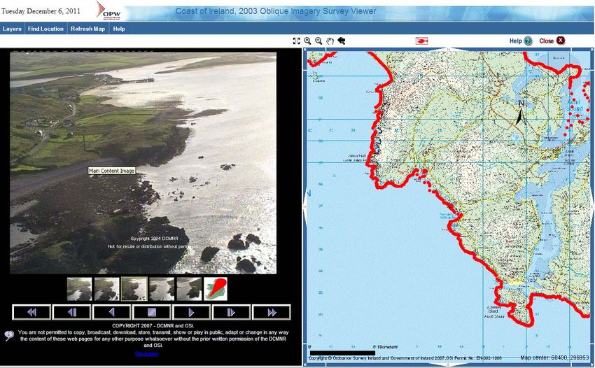
Change History of Report
 Date             New Rev   Author        Summary of Change

P4M006A-R003-03                                               ESB International
                                     ii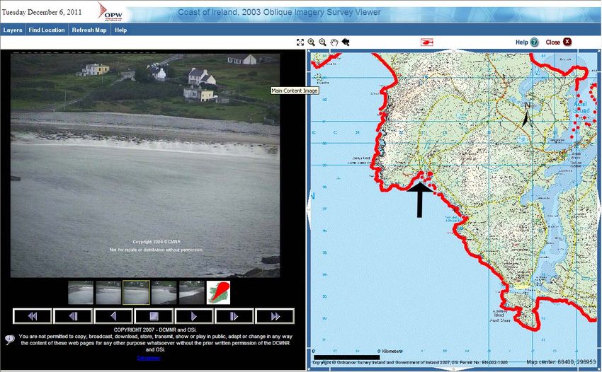
This page is intentionally blank

P4M006A-R003-03                          ESB International
                                   iii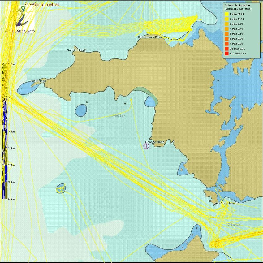
Contents

Executive Summary

1      INTRODUCTION............................................................................... 1
    1.1   Background............................................................................................................... 1
      1.1.1   WestWave project ............................................................................................. 1
      1.1.2   Potential Project Locations ................................................................................ 1
      1.1.3   Wave Energy Converter Technology................................................................. 2
      1.1.4   Overview............................................................................................................ 2
    1.2   Project Objective....................................................................................................... 3
    1.3   Proposed Development Outline Description............................................................. 3
    1.4   Screening & Scoping Opinion................................................................................... 4
    1.5   EIA Legislative Requirements................................................................................... 5
    1.6   Birds and Habitats Directive Requirement................................................................ 6
    1.7   Ramsar Convention on Wetlands ............................................................................. 6
    1.8   Convention on biological diversity ............................................................................ 7
    1.9   Water Framework Directive Requirements............................................................... 7
    1.10 Policy requirements .................................................................................................. 8
      1.10.1 Ocean Energy Strategy ..................................................................................... 8
      1.10.2 Ocean Renewable Energy Development Plan (OREDP) .................................. 8
      1.10.3 Mayo County Development Plan 2008–2014 .................................................... 9
      1.10.4 Mayo County Council Renewable Energy Strategy 2011– 2020..................... 10
      1.10.5 County Mayo Draft Biodiversity Action Plan (2010 – 2015)............................. 11
      1.10.6 County Mayo Heritage Plan............................................................................. 11
    1.11 Other Likely Requirements ..................................................................................... 11
    1.12 Document Structure................................................................................................ 11
2      PROJECT DESCRIPTION.............................................................. 13
    2.1   Project location ....................................................................................................... 13
    2.2   Project description .................................................................................................. 13
    2.3   Project technology .................................................................................................. 14
    2.4   Installation Methods................................................................................................ 15
      2.4.1    Device and Foundation Installation ................................................................. 15
      2.4.2    Pipelines .......................................................................................................... 15
      2.4.3    Onshore Components ..................................................................................... 16
      2.4.4    Grid Connection............................................................................................... 16
    2.5   Operation and Maintenance ................................................................................... 16
      2.5.1    Oyster Design Progression.............................................................................. 16
    2.6   Decommissioning ................................................................................................... 17
    2.7   Site selection process............................................................................................. 17
    2.8   Wave resource characterisation ............................................................................. 17
3      Existing Baseline........................................................................... 19
    3.1   Introduction ............................................................................................................. 19
    3.2   Seabed bathymetry................................................................................................. 19
    3.3   Onshore bedrock geology....................................................................................... 21
    3.4   Oceanography ........................................................................................................ 22
    3.5   Preliminary Ecological assessment ........................................................................ 22
      3.5.1    Conservation Designations.............................................................................. 22
      3.5.2    Intertidal and Marine Habitats.......................................................................... 27
      3.5.3    Marine Mammals ............................................................................................. 29
      3.5.4    Ornithology ...................................................................................................... 31

P4M006A-R003-03                                                                                          ESB International
                                                              i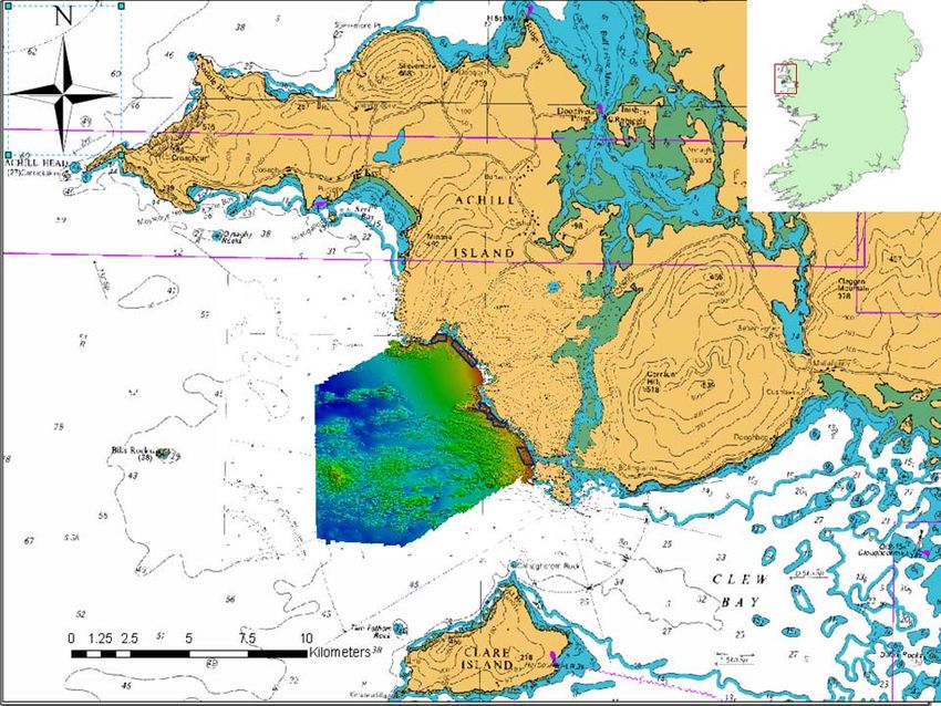
3.5.5 Terrestrial Habitats .......................................................................................... 32
3.6 Preliminary Cultural Heritage Baseline ................................................................... 32
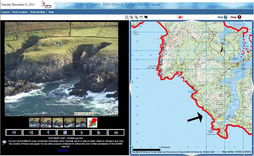
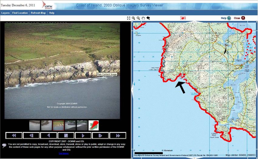
3.6.1 Site A - Ooghcorragaun, Dooega West ........................................................... 34
3.6.2 Site B - Ooghnashinnagh, Dooega East.......................................................... 34
3.6.3 Site C - Claggan .............................................................................................. 34
3.6.4 Site D - Doonnaglass....................................................................................... 34
3.6.5 Cultural Heritage Summary ............................................................................. 34
3.6.6 Shipwreck Inventory ........................................................................................ 35
3.7 Preliminary Navigation Data ................................................................................... 35
3.7.1 Preliminary AIS data........................................................................................ 35
3.7.2 Preliminary VMS data...................................................................................... 37
3.7.3 Potting activity ................................................................................................. 38
3.8 Water Quality .......................................................................................................... 39
3.9 Bathing waters ........................................................................................................ 39
3.10 Socio economic ...................................................................................................... 39
3.11 Transport ................................................................................................................ 40
3.12 Air quality ................................................................................................................ 40
3.13 Terrestrial Noise ..................................................................................................... 40
3.14 Marine Noise........................................................................................................... 40
3.15 Commercial Fisheries (including aquaculture)........................................................ 41
3.16 Shellfish Waters Directive....................................................................................... 41
4 OVERALL APPROACH TO ASSESSMENT OF
ENVIRONMENTAL IMPACTS .............................................................. 42
4.1 Overview................................................................................................................. 42
4.2 Consultation............................................................................................................ 42
4.3 Rationale and Alternatives to the Project................................................................ 43
4.4 Baseline .................................................................................................................. 43
4.5 Assessment of Environmental Impacts and their Significance ............................... 43
4.6 Development of Mitigation Measures ..................................................................... 44
5 POTENTIAL EFFECTS and ASSESSMENT METHODOLOGY .... 45
5.1 Introduction ............................................................................................................. 45
5.2 Landscape and Seascape ...................................................................................... 45
5.2.1 Potential Effects............................................................................................... 45
5.2.2 Assessment Methodology ............................................................................... 45
5.3 Physical Environment ............................................................................................. 46
5.3.1 Potential Effects to Coastal Processes............................................................ 46
5.3.2 Potential Effects from Drilling Works ............................................................... 47
5.3.3 Assessment Methodology ............................................................................... 47
5.4 Biological Environment ........................................................................................... 48
5.4.1 Potential Effects Subtidal Benthos .................................................................. 48
5.4.2 Assessment Methodology Subtidal Benthos ................................................... 48
5.4.3 Potential Effects Terrestrial Habitats and Intertidal Areas ............................... 49
5.4.4 Assessment Methodology Terrestrial Habitats and Intertidal Areas ................ 49
5.4.5 Marine Mammals ............................................................................................. 49
5.4.6 Assessment Methodology Marine Mammals ................................................... 50
5.4.7 Ornithology ...................................................................................................... 51
5.4.8 Assessment Methodology Ornithology ............................................................ 51
5.4.9 Appropriate Assessment ................................................................................. 52
5.5 Cultural Heritage..................................................................................................... 52
5.5.1 Potential Effects............................................................................................... 52
5.5.2 Assessment Methodology ............................................................................... 52
5.6 Socio-economic ...................................................................................................... 53
5.6.1 Potential Effects............................................................................................... 53
5.6.2 Assessment Methodology ............................................................................... 54
P4M006A-R003-03 ESB International
ii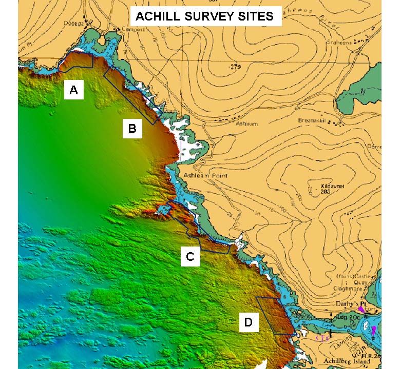
5.7   Transport ................................................................................................................ 54
      5.7.1    Potential Effects............................................................................................... 54
      5.7.2    Assessment Methodology ............................................................................... 55
    5.8   Navigation............................................................................................................... 55
      5.8.1    Potential Effects............................................................................................... 55
      5.8.2    Assessment Methodology, .............................................................................. 55
    5.9   Air Quality ............................................................................................................... 56
      5.9.1    Potential Effects............................................................................................... 56
      5.9.2    Assessment Methodology ............................................................................... 57
    5.10 Noise....................................................................................................................... 57
      5.10.1 Onshore Noise................................................................................................. 57
      5.10.2 Potential Effects Onshore Noise...................................................................... 57
      5.10.3 Assessment Methodology Onshore Noise ...................................................... 58
      5.10.4 Offshore Noise................................................................................................. 58
      5.10.5 Potential Effects Offshore Noise...................................................................... 58
      5.10.6 Assessment Methodology Offshore Noise ...................................................... 59
    5.11 Water and Sediment ............................................................................................... 59
      5.11.1 Potential Effects.............................................................................................. 59
      5.11.2 Assessment Methodology ............................................................................... 59
    5.12 Cumulative Impacts ................................................................................................ 60
6      ENVIRONMENTAL MANAGEMENT AND MONITORING PLAN .. 61
7      CONSULTATION RESPONSES .................................................... 61

List of Appendices

Appendix 1: Preliminary Ecological Site Assessment for the Proposed WestWave
            Project at Achill, Co. Mayo

Appendix 2: Preliminary Cultural Heritage Impact Assessment of Proposed WestWave
            Project at Achill, Co. Mayo

P4M006A-R003-03                                                                                           ESB International
                                                              iii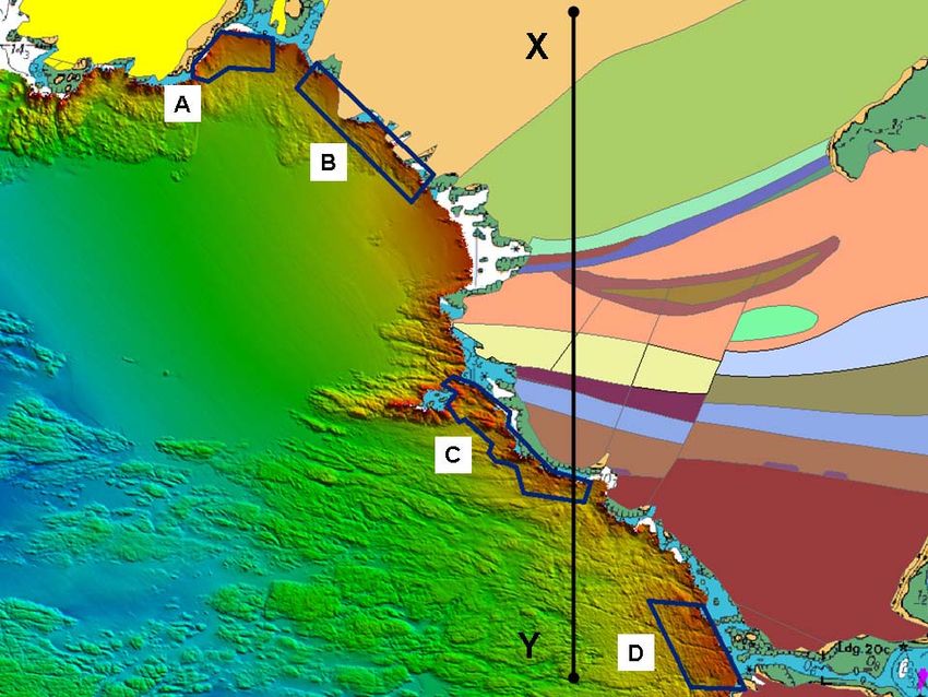
This page is intentionally blank.

P4M006A-R003-03                          ESB International
                                    iv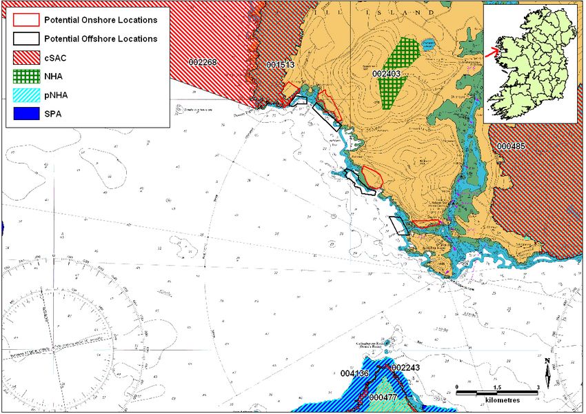
WestWave                                                       Environmental Scoping Report
Pilot wave energy site                                                         January 2012
___________________________________________________________________
EXECUTIVE SUMMARY

The WestWave project proposal is to develop a 5 MW wave energy project off the
west coast of Ireland by 2015. The project is led by ESB Energy International Limited
(ESBI) who will work with a number of wave energy technology partners in order to
develop the project.
This project is a collaborative approach from ESBI and other potential utility partners
to accelerate the development of the ocean energy sector in Ireland through the
development of a pre-commercial wave farm array off the west coast in line with Irish
Government Ocean Energy Strategy and the EU Ocean Energy Association’s
Roadmap. It is a ‘public good’ project which seeks to attract support from the EU
under NER300 funding mechanism as well as support from relevant state agencies
and departments in Ireland along with leading Irish and international wave energy
technology developers. ESBI believes this approach will deliver the best outcome for
Ireland and the EU leading to the development of commercial wave farm projects by
2020 and beyond.
The west coast of Ireland offers the best European resource in terms of wave energy
potential. The potential exists to develop a significant ocean energy industry with
sustainable long term employment and expertise. As part of the Ocean Energy
Strategy ESBI is proposing to develop a pilot scale wave energy farm at a location on
the west coast of Co Mayo. The exact location for the wave farm has not yet been
identified but there are a number of options in the general area of Achill Island
County Mayo which have been identified as offering potential to site the pilot wave
farm.
The WEC technology suited for this project in this nearshore location is the Oyster
device developed by Aquamarine Power Limited. This device operates in shallow
water up to 20 m in depth and will be located close to the shore. The Oyster device
has been on test in Billia Croo in Orkney and its characteristics are well understood.
Data as to its environmental performance will be available to enable assessment of
potential impacts and development of any required mitigation measures to be made.
The proposed development will comprise a total of six Oyster wave energy
converters. These will be fixed to the rocky seabed, each using a piled foundation.
The devices will be partially submerged with about 3m protruding above the sea
level. The Oyster device does not produce any electricity itself but pressurises water
in a high pressure pipeline to shore where electricity will be produced in the form of a
hydroelectric power plant. Onshore infrastructure will include the power plant,
substation and access road.
Installation of the devices will require piling of a foundation using a jackup barge and
support vessels, tugs and diver support vessels and a multicat vessel. Installation of
the 6 devices is expected to take about 4 months. Construction of the hydroelectric
power plant and access road is expected to take about 6 months.
Preliminary ecological and archaeological assessments, in the general location, have
been undertaken to assist in identifying the most appropriate final location for the
project. There are no protected areas in the marine or terrestrial environment at any
of the site options possible for the project but it is likely that near shore reef areas
would be protected under the Habitats Directive. Within fifteen kilometres of the area,
Special Protection Areas under the EU Birds Directive have also been designated as
important for seal and bird breeding. Assessment under Article 6.3 of the Habitats
Directive will be undertaken and a separate assessment report will be provided.

P4M006A-R003-03                          ES 1                               ESB International
WestWave                                                            Environmental Scoping Report
Pilot wave energy site                                                              January 2012
_____________________________________________________________________________________________

The development will require a foreshore lease from the Foreshore Licensing Unit of
the Department of the Environment, Community and Local Government and planning
permission from Mayo County Council.
If required a full Environmental Impact Statement in accordance with the
requirements of the European Communities (Foreshore) Regulations 2009, (S.I. No.
404 0f 2009) will be prepared.
All aspects of the project will be considered including, construction phase,
operational phase, decommissioning phase and potential cumulative impacts of other
plans or projects in the area.
An Environmental Management Plan and Environmental Monitoring Plan will be
developed in consultation with key stakeholders which will set out key management
and monitoring to be undertaken to monitor impact on the environment during all
project phases and provide a basis for corrective actions should these become
necessary.
The project will serve to integrate policy and knowledge needs in the marine
renewable energy area and will lead to the development of a robust approach and
methodology for assessment of projects of this type.
This report provides the basis of the request for screening and scoping opinion.

P4M006A-R003-03                              ES 2                                ESB International
WestWave                                                                      Environmental Scoping Report
Pilot wave energy site                                                                       January 2012

1 INTRODUCTION
1.1 Background
1.1.1 WestWave project
The WestWave project is a collaborative approach from ESBI and other potential utility partners to
accelerate the development of the ocean energy sector in Ireland through the development of a
pre-commercial wave farm array off the west coast in line with Irish Government Ocean Energy
Strategy1 and the EU Ocean Energy Association’s Roadmap2. It is a ‘public good’ project which
seeks to attract support from the EU under NER300 funding mechanism as well as support from
relevant state agencies and departments in Ireland along with leading Irish and international wave
energy technology developers. ESBI believes this approach will deliver the best outcome for
Ireland and the EU leading to the development of commercial wave farm projects by 2020 and
beyond.
The WestWave project proposal is to develop a 5 MW wave energy project off the west coast of
Ireland by 2015 to be financed by ESBI and other potential utility partners with significant financial
support via EU NER3003 funding and other sources of domestic grant funding in addition to
support under the Republic of Ireland REFIT tariff for wave energy. The project is led by ESB who
will work with a number of wave energy technology partners in order to develop the project. A
Memorandum of Understanding (MOU) was signed between ESBI and four of the leading wave
energy technology developers on 3rd November 2010. The technology developers who are party to
the MOU are Aquamarine Power Limited, Pelamis Wave Power Limited, Ocean Energy Limited
and Wavebob Limited. In order to extend the benefits of the project and to bring-in additional
capabilities, it is envisaged that other utilities will become party to the project in due course.
The key phases of the project are:
2011:             Concept Development Phase
2012–2013: Consenting and Detailed Design Phase
2014:             Financial Close
2014-2015: Construction Phase
2016 on :         Operational Phase
                  De-Commissioning Phase

1.1.2 Potential Project Locations
ESBI carried out a site selection study and identified eleven potential candidate areas. The criteria
used to assess the sites included seabed conditions, wave power, marine traffic, local area
considerations, required infrastructure, network conditions, environmental constraints, onshore
works, port facilities and other marine users and activities. Following this process, three preferred
sites were selected based upon this initial assessment and the site selection is now focused on
collecting more detailed information about the three locations in order to make a final selection.
The three preferred sites identified by the study are:
Site off Annagh Head, Mullet Peninsula, Co Mayo
This site is suitable for ’off-shore‘ technology, deep water converters with mooring depths of 50 to
100m. This site is located at the Atlantic Marine Energy Test Site (AMETS) which is being
developed by Sustainable Energy Authority of Ireland (SEAI) and the Marine Institute (MI). This
site is very familiar to the WestWave project as ESBI has been providing full engineering design,

1
  Ocean Energy in Ireland Report October 2005
2
  EU-Ocean Energy Association (OEA) Roadplan 2010-2050
3
  (http://www.ner300.com/)

______________________________________________________________________________
 P4M006A-R003-03
                                        1                         ESB International
WestWave Environmental Scoping Report
Pilot wave energy site January 2012
environmental and engineering services to SEAI for AMETS over the last three years. The site is
well characterised and a Foreshore Lease has been sought for this site which can accommodate
small arrays of WECs. Information on this site can be found at www.seai.ie and www.marine.ie.
Site south off Achill Island, Co Mayo
This site is located to the south of Achill Island from Dooega Point to Croaghmore. This site is
suitable for ‘near-shore’ wave energy converter technology. Sea bed surveying and wave
measurements have been ongoing at this location since 2011.
Site close to Killard, Co Clare
This site is to the west of Doonbeg and close to Killard Point, Co Clare. This site is also suitable for
‘near-shore’ technology and sea bed surveying and wave measurements have been ongoing at
this location since 2011.
1.1.3 Wave Energy Converter Technology
The four technology partners in the WestWave project have been assessed by ESBI to ensure that
their wave energy converter technology is ready for the timeline required by the WestWave project.
The technology assessment method, “Technology Readiness Levels” and certification approach
are outlined further on the project website4. Technology partners have to:
Demonstrate Ocean Operational Readiness by October 2010 such as 1:2 scale or larger
WEC in an open ocean environment.
Demonstrate Pre-Commercial Project Readiness such as full-scale, single device hardware
tested and demonstrated before an investment decision is made to construct the project.
The deep water Wave Energy Converter devices (developed by Pelamis Wave Power Limited,
Ocean Energy Limited and Wavebob Limited) are potentially suitable for the deep water (greater
than 50m) site at Annagh Head, Co Mayo as designed. The nearshore (less than 25m) device
(developed by Aquamarine Power Limited) is potentially suitable for the nearshore locations at
Achill Island, Co Mayo or Killard Co Clare.
The wave energy converter (WEC) technology proposed for this project at a nearshore location is
the Oyster device developed by Aquamarine Power Limited. This technology utilises wave energy
in relatively shallow waters, up to 20m water depth. The Oyster itself does not generate electricity
directly but pressurises water in a high pressure pipeline to drive an onshore hydroelectric power
plant to produce electricity.
Aquamarine Power’s first full-scale 315kW Oyster was officially launched at the European Marine
Energy Centre (EMEC) in Orkney in November 2009. It tested successfully with over 6000 offshore
operating hours in the open ocean environment. The first of three next generation Oyster 800
devices has now been deployed at Orkney as part of a three WEC array which will deliver up to 2.4
MW into the electricity grid. Aquamarine Power is currently performing early engineering for the
latest generation Oyster 800 WEC device.
1.1.4 Overview
This Environmental Scoping Document considers the proposal to develop a nearshore project
using Aquamarine Power’s Oyster device at the site on the west coast of Achill in County Mayo,
Ireland by 2015.
This report has been prepared by ESBl and represents the first stage of the Environmental Impact
Assessment (EIA) process. It has been produced to facilitate the identification and assessment of
the potential environmental impacts associated with the project.
More information can be found on the websites, www.esbi.ie and www.WestWave.ie.
4
www.WestWave.ie
______________________________________________________________________________
P4M006A-R003-03
2 ESB InternationalWestWave Environmental Scoping Report
Pilot wave energy site January 2012
1.2 Project Objective
The principle purpose of this project is to demonstrate that a pilot wave energy project can be
designed, consented, developed and operated in Ireland using innovative wave energy conversion
technologies. Aside from the confidence in technology, construction and operation and
maintenance, the project will also aim to lay foundations and stimulate the market in terms of
consenting processes, grid access and local infrastructure required for Ireland to realise its
ambitions in the Ocean Energy sector and lead to the development of commercial ocean energy
projects in Ireland and the EU towards 2020.
1.3 Proposed Development Outline Description
The WestWave project proposed for Achill Island will consist of six Oyster wave energy converter
devices, high and low pressure water pipelines, onshore hydroelectric plant (HEP), two drive trains
and a connection to the existing grid. The WECs will be located in the sea at distances up to 1km
from the coast at depths ranging up to 20m. Although a general location on Achill Island has been
selected for the WestWave project a number of specific sites are under review where the project
may be finally installed. The potential project locations are shown on Figure 1. They are located in
the sea offshore and on land in the townland areas of:
Ooghcorragaun West
Ooghcorragaun East
Claggan
Doonaglass
______________________________________________________________________________
P4M006A-R003-03
3 ESB InternationalWestWave Environmental Scoping Report
Pilot wave energy site January 2012
Figure 1: Potential onshore and off-shore project locations
1.4 Screening & Scoping Opinion
This joint Environmental Screening and Scoping Report relates to the following elements of the
proposed development:
1. The wave energy converters near shore areas.
2. The high and low pressure water pipes and interconnecting pipes.
3. The Hydroelectric Power Plant and access road on shore associated with the near shore
area.
The consents required for the onshore element of the work, which is those under the responsibility
of the Distribution System Operator (ESB Networks) and separate from the substation, are being
dealt with separately. These elements constitute a wooden pole, to approximately 11m in height,
and overhead line conductor. They will be dealt with by the Distribution System Operator and thus
are not discussed in detail within this report. In the context of this report therefore, the development
is defined as the offshore WEC array area, water pipelines and hydroelectric power plant.
ESBI is seeking a formal screening opinion as to whether an Environmental Impact Assessment
(EIA) will be required for the proposed development and the extent of information which should be
included. This document has been produced in support of the formal request for a screening
opinion from Consultees with the purpose of providing:
a description of the proposed development;
an initial description of the existing baseline in the project area;
______________________________________________________________________________
P4M006A-R003-03
4 ESB InternationalWestWave Environmental Scoping Report
Pilot wave energy site January 2012
a description of any environmental constraints in the area;
a description of the development’s possible effects on the environment both positive and
negative;
a description of the approach and studies which may be required to fulfil the Environmental
Impact Assessment (EIA) requirements and prepare an Environmental Impact Statement
(EIS) if required; and
other relevant information that will assist in making the scoping decision.
In addition to requesting a formal screening opinion, where it is considered by the determining
authority (Department of Environment, Community and Local Government in Ireland) that an EIA is
required for the proposed development, ESBI wish to seek a formal scoping opinion from the
determining authority in conjunction with that decision. This document therefore also forms the
basis for ESBI’s request for a formal scoping opinion in the event that an EIA is considered
necessary for the development. The purpose of scoping is to refine the capacity of the EIA, should
it be confirmed as a requirement, and ensure that it is robust in its approach.
This report provides a description of the proposed development, outlines the potential effects that
the development may have on the environment, and the methods of assessment that will be
employed in assessing environmental impacts. For example field surveys for archaeology, birds,
marine mammals and terrestrial ecology are planned as part of the baseline establishment. This
document is for issue to the determining authorities and relevant consultees within Ireland in order
to receive opinion on the project and the methods proposed.
Information used in this report is based upon an initial desk-based appraisal, using available
published information, preliminary ecological, archaeological and navigation assessment of the
baseline, some limited field work and initial public consultation.
1.5 EIA Legislative Requirements
The Department of the Environment, Community and Local Government
In Ireland, the foreshore is owned and administered by the State. The foreshore is defined as the
seabed and resources between the Mean High Water mark and the 12 nautical mile territorial limit,
the zone within which the proposed development will be constructed and operated.
The required consents for the project include a foreshore lease from the Irish government’s
Department of the Environment, Community and Local Government (DECLG) for all
installations between the high water mark and the 12 nautical mile limit.
Consent and a lease will be required for the construction and operation of the proposed
development under the Foreshore Acts (1933–2003), administered by the DECLG, Coastal Zone
Management Division (CZMD), Foreshore Section.
If required, an EIA would be submitted under the European Communities (Foreshore) Regulations
2009 (S.I. No. 404 of 2009).
Consents are also required under the Foreshore Acts on landfall areas that are privately owned,
although leases would not be necessary for any areas of privately owned foreshore.
Any dredging or dumping activities will require a separate consent regulated under the Dumping at
Sea Act (1996). This act implements the requirements of the OSPAR Convention. All permit
applications for the dumping of dredged spoil at sea are processes by the DECLG and CZMD.
______________________________________________________________________________
P4M006A-R003-03
5 ESB InternationalWestWave Environmental Scoping Report
Pilot wave energy site January 2012
1.6 Birds and Habitats Directive Requirement
The European Union’s Habitats Directive (Council Directive 92/43/EEC on the conservation of
natural habitats and of wild flora and fauna), in conjunction with the Birds Directive (Council
Directive 79/409/EEC on the conservation of wild birds) is the main legal tool of the European
Union for nature conservation. The Habitat Directive seeks to establish "Natura 2000", a network of
protected areas throughout the European Community. Member States are required to maintain or
restore at ‘favourable conservation status’ the habitats and species of Community importance
listed in Annex I and II of the Directive. The areas chosen as Special Areas of Conservation (SAC)
in Ireland cover an area of approximately 13,500km2. There are 121 Special Protected Areas
(SPAs) designated in Ireland.
The proposed WestWave locations are not sited within any Natura 2000 site but are located in their
vicinity and as such these directives apply.
Article 6.3 of the Habitats Directive states:
‘any plan or project not directly connected with or necessary to the management of the site but
likely to have a significant effect thereon, either individually or in combination with other plans or
projects, shall be subject to appropriate assessment of its implications for the site in view of the
site's conservation objectives’
There are no designated cSAC, pNHA or SPA in the marine environment at the location of the
proposed development. However, within fifteen kilometres of the area there are a number of
designated areas under the Birds and Habitats Directive (Table 1).
Table 1: Designated area within 15 km of potential WestWave locations
Site name Site Code
Achill Head cSAC 002268
Croaghaun / Slievemore cSAC & pNHA 001955
Keel Machair / Menaun Cliffs cSAC & 001513
pNHA
Bill Rocks SPA 004177
Clare Island SPA 004136
Clare Island Cliffs cSAC 002243
Corraun Plateau cSAC & pNHA 000485
Sraheens Bog NHA 002403
Bills Rocks pNHA 000469
Inishgallon pNHA 001967
Clare Island pNHA 000477
There may also be Priority 1 Habitat in the marine environment comprising of reefs in the near
shore area.
Given the proximity of the WestWave site to designated areas a Natura Impact Statement (NIS)
will be required to be prepared separately for the project.
1.7 Ramsar Convention on Wetlands
The Convention on Wetlands, signed in Ramsar, Iran, in 1971, is an intergovernmental treaty,
which provides the framework for national action and international co-operation for the
______________________________________________________________________________
P4M006A-R003-03
6 ESB InternationalWestWave Environmental Scoping Report
Pilot wave energy site January 2012
conservation and wise use of wetlands and their resources. One of the criteria for international
importance is that the site regularly (i.e. over a period of five years) holds 1% of the biogeographic
population of a species or 20,000 individuals. There are no Ramsar sites in the vicinity of the
proposed WestWave locations and therefore will not be an issue.
1.8 Convention on biological diversity
The Convention on Biological Diversity (CBD) was one of the three environmental
recommendations to come out of the 1992 Rio de Janerio Earth Summit on Environment and
Development. The CBD is pre-eminent amongst nature/biodiversity-related conventions, both in
terms of its widespread support and its comprehensive scope. It represents the charter within
which nature conservation and other issues relevant to the conservation and sustainable use of
biodiversity must be addressed on a worldwide basis. The convention has three main objectives:
the conservation of biological diversity;
the sustainable use of components of biological diversity; and
fair and equitable sharing of the benefits arising out of the utilisation of genetic resources
Due to the fact that the proposed WestWave sites are in the vicinity of Natura 2000 sites, this
convention is relevant to the project.
1.9 Water Framework Directive Requirements
The European Communities (Water Policy) Regulations, 2003, (S.I. 722 of 2003) is the enabling
Irish legislation of the European Communities Water Framework Directive5.
In brief the enabling legislation provides for the protection of the status of all waters (surface and
groundwater), the establishment of “river basin districts” (RBDs), co-ordination of actions by all
relevant public authorities for water quality management in an RBD including cross-border RBDs,
characterisation of each RBD, establishment of a Register of Protected Areas, establishment of
environmental objectives and the development of programmes of measures and river basin
management plans (RBMP).
A Final RBMP, covering the period 2009 to 2015, has been adopted by Mayo County Council on
the 12th April 2010. The Plan is implemented jointly by the Local Authorities in the WRBD, of which
Mayo County Council is one, and the lead Local Authority, with overall co-ordinating role, is
Galway County Council. A full description of the river basin and its characteristics as well as the
WFD objectives can be found on www.wfdireland.ie and on www.westernrbd.ie.
The Western River Basin Management Plan (2009 - 2015) establishes four core environmental
objectives to be achieved generally by 2015:
prevent deterioration of water status;
restore good status where status is assigned as less than good by the EPA;
reduce chemical pollution; and
achieve water related protected areas objectives.
In addition, the Surface Waters Environmental Objectives Regulations (SI 272 of 2009) and the
Groundwater Environmental Objectives Regulations (SI 9 of 2010) were made to give effect to the
measures needed to achieve surface water and groundwater environmental objectives established
in river basin management plans. The Regulations place a legal obligation on public authorities to
aim to achieve those objectives in the context of their statutory functions.
5
Directive 2000/60/EC of the European Parliament and of the Council of 23 October 2000, establishing a
framework for Community action in the field of water policy
______________________________________________________________________________
P4M006A-R003-03
7 ESB InternationalWestWave Environmental Scoping Report
Pilot wave energy site January 2012
The proposed WestWave project area comes within the Western River Basin District (WRBD)
River Basin Management Plan (RBMP) management area (www.wfdireland.ie). The proposed
WestWave offshore locations are within the Western Atlantic Seaboard Coastal water body
(IE_WE_250_0000). As such the requirements of the river Basin Management Plan must be
adhered to.
All of the potential locations for the Hydroelectric Power Plant are situated outside of any surface
river water body as defined by the Environmental Protection Agency under the Water Framework
Directive and are located within inter-basin water bodies as identified in the Mayo West Water
Management Unit6.
1.10 Policy requirements
1.10.1 Ocean Energy Strategy
Ireland’s Ocean Energy Strategy was developed to advance Ireland’s capability to deploy ocean
energy technology and develop an industry sector in this field of emerging energy technology. It
proposed a four phase strategy to capitalise on Ireland’s marine energy resource.
Phase 1 (2005 to 2007) This phase focuses on development by supporting product
R&D and research facilities with an objective to develop and
test prototype concepts and develop technical leadership in
this area.
Phase 2 (2008 to 2010) This phase supports the development of pre-commercial grid
connected devices with the objective of demonstrating the
potential for a cost-effective fully functional wave energy
converter operating in the Irish electricity market.
Phase 3 (2011 – 2015) This phase could provide support for a 10MW large-scale
array of devices to be connected to the grid.
Phase 4 (2016 onwards) This phase sees large-scale market deployment for ocean
energy.
This phased strategy aims
to introduce ocean energy into the renewables portfolio in Ireland; and
to develop an Irish ocean energy industry sector.
The 2007 Government White Paper on energy policy ‘Delivering a sustainable energy future for
Ireland – The Energy Policy Framework 2007-2020’ sets out a number of strategic goals, including
a specific ocean (wave and tidal) energy target of 500 MW by 2020. This target was then restated
in the 2007 Programme for Government.
WestWave is a component of Phase 3 of the Ocean Energy strategy and will contribute towards
fulfilling the wave and tidal energy target of 500 MW by 2020.
1.10.2 Ocean Renewable Energy Development Plan (OREDP)
The Department of Communications, Energy & Natural Resources (DCENR), with input from the
Sustainable Energy Authority of Ireland (SEAI), is in the process of developing the Offshore
Renewable Energy Development Plan (OREDP), which will shape the exploitation of offshore wind
and renewable energy resources in Ireland’s marine territory.
6
www/wfdireland.ie
______________________________________________________________________________
P4M006A-R003-03
8 ESB InternationalWestWave Environmental Scoping Report
Pilot wave energy site January 2012
The main aim of the OREDP is to establish scenarios for the development of offshore renewable
resources in Irish waters up to 2030, and to provide a description of developing policy, which will
affect the context within which they may develop.
The OREDP area covers all Irish waters from the Mean High Water Mark out to the 200m water
depth contour off the west and south west coast of Ireland and the Exclusive Economic Zone
(EEZ) off the north, east and south east coasts of Ireland.
A Draft Strategic Environmental Assessment (SEA) in compliance with the Planning and
Development (Strategic Environmental Assessment) Regulations 2004, has been prepared under
the provisions of S.I. No. 94/1997 – European Communities (Natural Habitats) Regulations, 1997
(as amended) and a draft Natura Impact Statement as the plan may affect sites designated as
being of European importance (collectively, Natura 2000).
Copies of the draft OREDP, the SEA and the Natura Impact Statement for the Plan are available
for download at http://www.seai.ie/Renewables/Ocean_Energy/.
1.10.3 Mayo County Development Plan 2008–2014
The current applicable Mayo County Development Plan is the 2008-2014 edition which encourages
the production of energy from renewable sources under reference TI-RE 2, with a specific
reference to wave and tidal among other sources (Mayo, 2008 – 2014). It recognises that natural
resources are a vital element of the county’s resource base and that they have not been developed
to their full potential. The development of renewable resources is specifically addressed as part of
its overall strategy for transport and infrastructure developments, where it aims to optimise the
development of appropriate renewable energy sources that make use of the natural resources of
the area concerned in an environmentally acceptable and sustainable manner.
The quality of the landscape is recognised as a key economic resource and the county has been
divided into ‘Landscape Protection Policy Areas’. It is also recognised that the development of the
county’s natural resources is necessary for economic survival and prosperity.
Landscape appraisal
In the “Landscape Appraisal of County Mayo” Achill island forms part of Area A (Area A: Achill,
Clare, Inishturk and related Coastal Complex). This area is described as
“being distinct from the remainder of Mayo's coast to the north due to the steep topography and
relatively uniform upland moor appearance. The overriding characteristic of this area remains the
almost constantly visible coastline with Slievemore on Achill Island, at 671m in height, as a
dominating feature. Dramatic vistas of steep mountain sides and sea cliffs falling to the sea are
common”
Critical landscape factors are the elevated coastal vistas, steep slopes, prominent ridge lines,
smooth terrain and low vegetation. The main concerns identified for natural linear features such as
coastlines and ridge lines being to avoid penetration by development that will interrupt and reduce
the integrity of such elements.
The coastline from Killala Bay to Killary Harbour are designated as vulnerable. The WestWave
project will be located within this vulnerable area. To be considered for permission, development in
the environs of these vulnerable areas must be shown not to impinge in any significant way upon
its character, integrity or uniformity when viewed from the surroundings. Particular attention should
be given to the preservation of the character and distinctiveness of these areas as viewed from
scenic routes and the environs of archaeological and historic sites.
In addition the Local road (i.e. "The Atlantic Drive") at Dooega Head (southern part of Achill Island),
from the R319 through Dooega, Cloghmore and Derreen is designated as a scenic route (Section
3.6 a Areas designated as scenic route). The WestWave Project will be located along this route.
Scenic routes indicate public roads from which views and prospects of areas of natural beauty and
interest can be enjoyed. The onus will be on the applicant when applying for permission to develop
in the environs of a scenic route, to demonstrate that there will be no obstruction or degradation of
______________________________________________________________________________
P4M006A-R003-03
9 ESB InternationalWestWave Environmental Scoping Report
Pilot wave energy site January 2012
the views towards visually vulnerable features nor significant alterations to the appearance or
character of sensitive areas.
The County Development Plan also outlines its development objectives in relation to natural
heritage and under EH-NH 1 and states that ‘It is an objective of the Council to protect, enhance
and conserve areas designated as candidate Special Areas of Conservation, Special Protection
Areas and proposed National Heritage Areas…’
1.10.4 Mayo County Council Renewable Energy Strategy 2011– 2020
Mayo County Council adopted its Renewable Energy Strategy on 9 May 2011. The Strategy sets
out a path to allow County Mayo to contribute to meeting the national legally-binding renewable
energy targets and clarifies the approach Mayo County Council takes to renewable energy. All
major forms of renewable energy are considered in the Strategy, including ocean energy.
Mayo has potential to harness 18,500–19,500MW of renewable energy from fixed wind, floating
wind and wave resources. However it is considered that less than half of this (4,900–7,900MW)
can be exploited in an environmentally sensitive manner.
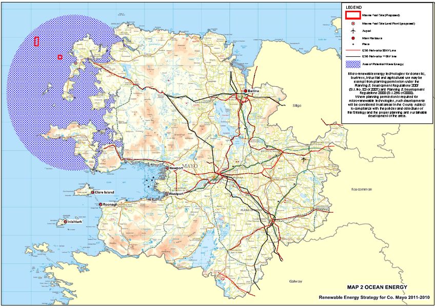
The area identified by Mayo County Council for wave energy potential in the strategy is reproduced
in Figure 2. The WestWave potential sites are located within this area. The Strategy identifies the
potential for Mayo to become a centre for research and development in ocean energy.
With respect to individual projects the Strategy states that permitting any onshore infrastructure
associated with offshore wave energy developments will be determined in accordance with the
principles of proper planning and sustainable development with a view to ensuring minimal adverse
environmental impact. Developments must take account of the presence of and requirement to
protect all Natura 2000 sites and also Local Biodiversity Areas. All proposed renewable energy
development in marine waters or associated landward elements will be subject to an ecological
impact assessment.
Figure 2: Mayo County Council Renewable Energy Strategy – Potential Wave Energy Map
______________________________________________________________________________
P4M006A-R003-03
10 ESB InternationalWestWave Environmental Scoping Report
Pilot wave energy site January 2012
1.10.5 County Mayo Draft Biodiversity Action Plan (2010 – 2015)
The County Mayo Draft Biodiversity Action Plan covers the period 2010 to 20157. Its stated vision
is:
“That Mayo becomes a place even richer in wildlife and wild places that is cherished and respected
by all, and for the benefit of all.”
The plan provides a framework for the conservation of biodiversity and natural heritage at a local
level and is designed to ensure that national and international targets for the conservation of
biodiversity can be achieved while at the same time addressing local priorities. The plan was
produced as an action in the first National Biodiversity Plan published in 2002, which recognised
the key role of local authorities in protecting our natural heritage. It was prepared following the
guidelines produced by the Heritage Council and with regard to the National Biodiversity Plan, the
County Mayo Heritage Plan 2006- 2011 and the County Mayo Development Plan 2008-2014.
The Plan identifies the main threats to nature and biodiversity in the county as being habitat
destruction and fragmentation, development pressure, drainage, pollution, invasive species
and climate change.
The Plan has three stated objectives as follows:
Objective 1: Increase awareness, understanding and appreciation of Mayo’s biodiversity and
natural heritage.
Objective 2: Collect and make accessible biodiversity/ natural heritage information
Objective 3: Promote best practice in natural heritage management and conservation
1.10.6 County Mayo Heritage Plan
The County Mayo Heritage Plan was prepared by the County Mayo Heritage Forum and covers the
period 2006 – 20118. The aim of the plan is to identify, raise awareness of and promote the
conservation of the built, natural and cultural heritage of the county. The Heritage Plan is not a
statutory plan or policy document but compliments the County Development Plan. Its three core
objectives are:
Objective 1 - Promotion of Awareness and Appreciation of our Heritage
Objective 2 - Collection and Dissemination of Heritage Information
Objective 3 - Promotion of Best Practice in Heritage Management and Conservation
1.11 Other Likely Requirements
There are several other consents and licences that will be required in order to construct and
operate the proposed development in Irish coastal waters. The requirements for such consents will
be determined in consultation with the relevant authorities. For example planning permission for
the hydroelectric plant will be required from Mayo County Council.
1.12 Document Structure
In order to accord with scoping best practice, when making a scoping request the developer is
required to include:
a plan sufficient to identify the land or site(Figure 1);
a brief description of the nature and purpose of the development (Section 2);
7
Draft County Mayo Biodiversity Action Plan, 2010 – 2015, Mayo County Council, 2010
8
County Mayo Heritage Plan 2006 - 2011
______________________________________________________________________________
P4M006A-R003-03
11 ESB InternationalWestWave Environmental Scoping Report
Pilot wave energy site January 2012
a description of the baseline (Section 3)
a description of the development’s possible effects on the environment (Section 5); and
such other information or representations as the person making the request may wish to
provide or make (Sections 4 and 7).
These requirements are addressed in this scoping report as indicated above. Section 7 describes
the procedure for making comments in relation to this scoping exercise.
This report provides the basis of the request for screening and scoping opinions in Ireland.
______________________________________________________________________________
P4M006A-R003-03
12 ESB InternationalWestWave Environmental Scoping Report
Pilot wave energy site January 2012
2 PROJECT DESCRIPTION
2.1 Project location
The proposed locations under consideration for the WestWave project are located on the west
coast of Achill Island in County Mayo. A final location has not yet been decided and a number of
additional factors such as land availability, accessibility and resource modelling have yet to be
completed before a location can be finalised.
2.2 Project description
The proposed development will comprise a total of 6 near shore Oyster wave energy converters
(WECs). The Oyster device is being developer by WestWave technology partner Aquamarine
Power. The devices will be fixed to the rocky seabed, each using a piled foundation. The devices
will be partially submerged in operation, with about 3.5m protruding above the sea surface
(relative to Mean Sea Level (MSL). There will be a minimum separation between devices of at
least 25m. The exact array layout will be informed by a range of factors including technology
development, hydraulic modelling, analysis of site survey, and other environmental data and will be
designed to maximise the capture of wave energy resource at the particular location finally
selected with the minimum footprint possible.
The wave farm will not generate any electricity in-situ. The flap of each device will pump water, via
a high pressure undersea pipeline, to the onshore hydroelectric power plant. The water will be
returned to the flap via a low pressure return pipeline. The pipe lines to and from the onshore
installation will be directionally drilled through the bedrock. The pressurised freshwater will drive an
on shore hydroelectric power plant containing a hydroelectric turbine, generator equipment, a
header tank and a storage/site office area. The turbine is based on existing hydro-electric (pelton
wheel) technology transforming water pumped by the device to shore. The WECs will be
interlinked by a pipework connected through bridge structures on the seabed. The hydroelectric
powerplant will be linked via a small substation to the existing grid on Achill island.
The project will comprise a number of components as follows:
Nearshore wave energy converter Array, consisting of 6 Oyster wave energy converters in
water depths up to 20m.
Interlinking high and low pressure pipe work on pipe bridges on the seabed between the
devices.
High pressure water pipelines from the WEC array to the onshore hydroelectric power
plant.
Low pressure water pipelines from the WEC array to the onshore hydroelectric power plant.
Onshore hydroelectric power plant with Pelton wheel turbines incorporating a small
substation.
Access road to the hydroelectric power plant location.
Dedicated feeder overhead power line (wooden pole) from a dedicated substation to grid
substation (Construction responsibility of the distribution system operator (DSO) ESB
Networks).
Each Oyster device flap will be 26m in width and approximately 12m from the top of the flap to
bottom of baseframe. The expected footprint of the Oyster array will be over an area of seabed of
up to 1 hectare but will be dependent on bathymetry and local variations which may influence
sighting . The expected footprint of the hydroelectric powerplant and substation will be about 1 acre
______________________________________________________________________________
P4M006A-R003-03
13 ESB InternationalYou can also read


