Agricultural*Assessment * Specialist*Screening* Kappa*-*Sterrekus* Powerline* - Report*of*the*2nd*765*kV
←
→
Page content transcription
If your browser does not render page correctly, please read the page content below

Agricultural*Assessment******                          *
             Specialist*Screening*
            Report*of*the*2nd*765*kV* *
              Kappa*–*Sterrekus*
                   Powerline*
                             **********Prepared*for*
                                                                   *
            **********Eskom*Holdings*SOC*

                                                               !
              !!!!!!!!!!!!                             !
                                                           *

    !

                                                   *

*                                                                  !
                                                           !
                 Prepared*by*                              !
                                                           !
                Agriexpert*CC*                             !
                                                           !
            Date:*12*February*2021*                        !

        !

        !

!
                                             i!!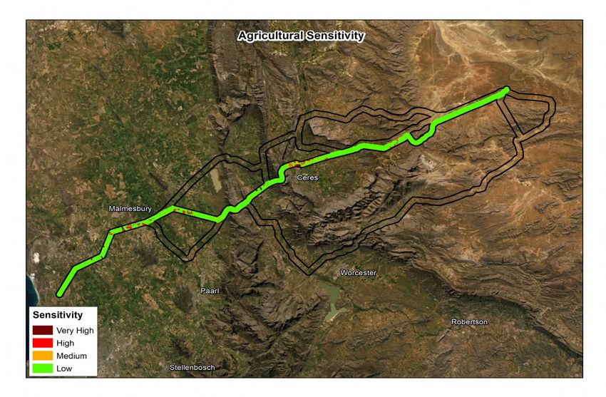
Kappa&!Sterrekus!Powerline!Specialist!Screening!Report:!Agricultural!Potential!Assessment!   !

          !

          Agricultural*Specialist*Screening*Study*of*the*
          2nd*765*kV*Kappa*–*Sterrekus*Powerline*
          !
!
          !
          !
          !
          Date:*12*February*2021*
          !

    ********Authors:**                                                   **

    ********Iaan*Olckers*
    !!!!!!!!!Renier*van*Schalkwyk!

              !                                                          !!

              !
              *
              !

          !

                                                                  ii!
                                                                   !
Kappa&!Sterrekus!Powerline!Specialist!Screening!Report:!Agricultural!Potential!Assessment!                                          !

Table*of*Contents*
!

1! Introduction*..................................................................................................................*1!
2! Project*Description*......................................................................................................*4!
3! Approach*and*Methodology*.......................................................................................*7!
4! Baseline*Characteristics*of*the*Project*Area*..........................................................*12!
5! Agricultural*Sensitivity*..............................................................................................*31!
6! Conclusion*.................................................................................................................*44!
7! References*.................................................................................................................*46!
*    *                                      *

*
Appendices*
    Appendix!A!               Specialist!CV!
    Appendix!B!               Declaration!of!Independence!!

*

                                                                 iii!
                                                                  !
Kappa&!Sterrekus!Powerline!Specialist!Screening!Report:!Agricultural!Potential!Assessment! !
List*of*Tables*
Table!1!&!Interpretation!of!Sensitivity!
Table!2!&!Sensitivity!Feature!Class!!
Table!3!&!Data!Sources!
Table!4!&!Sensitivity!Feature!Classes!!
Table!5!&!Site!Selection!Matrix.!
List*of*Figures*
Figure!1:!Powerline!sub&corridor!alignment!alternatives!
Figure!2:!Powerline!Sub&Region!Overview!
Figure!3:!Established!Pivot!Infrastructure!in!place!
Figure!4.1:!Overall!Agricultural!Sensitivity&!Central!A!Alignment!&!Northen!Option!
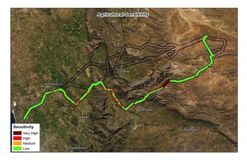
Figure!4.2:!Overall!Agricultural!Sensitivity!&!Central!A!Alignment!–!Southern!Option!
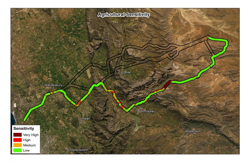
Figure!5:!Overall!Agricultural!Sensitivity&!Central!B!Alignment!
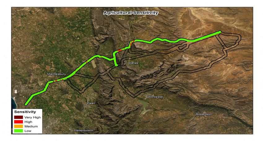
Figure!6.1:!Overall!Agricultural!Sensitivity&!Southern!Alignment!&!Eastern!Option!
Figure!6.2:!Overall!Agricultural!Sensitivity&!Southern!Alignment!&Western!Option!
!
Abbreviations*
CC! Climate!Change!
DEA! Department!of!Environmental!Affairs!
Eskom! Eskom!Holdings!SOC!
Ha! Hectare!
kV! Kilovolt!
Ltd! Limited!!
SEA! Strategic!Environmental!Assessment!
SRK! SRK!Consulting!(South!Africa)!(Pty)!Ltd!!
WCG!!! Western!Cape!Government!!!!!!!
!
! !
! !
! !
! !
iv!
!
Kappa&!Sterrekus!Powerline!Specialist!Screening!Report:!Agricultural!Potential!Assessment! !
1* Introduction*
Eskom! Holdings! SOC! (Eskom)! has! appointed! SRK! Consulting! (South! Africa)! (Pty)! Ltd! (SRK)! to!
undertake!an!environmental!study!(the!study)!of!the!second!765kV!transmission!powerline!between!
the!Kappa!and!Sterrekus!substations!(the!Project).!The!purpose!of!the!study!is!to:!!
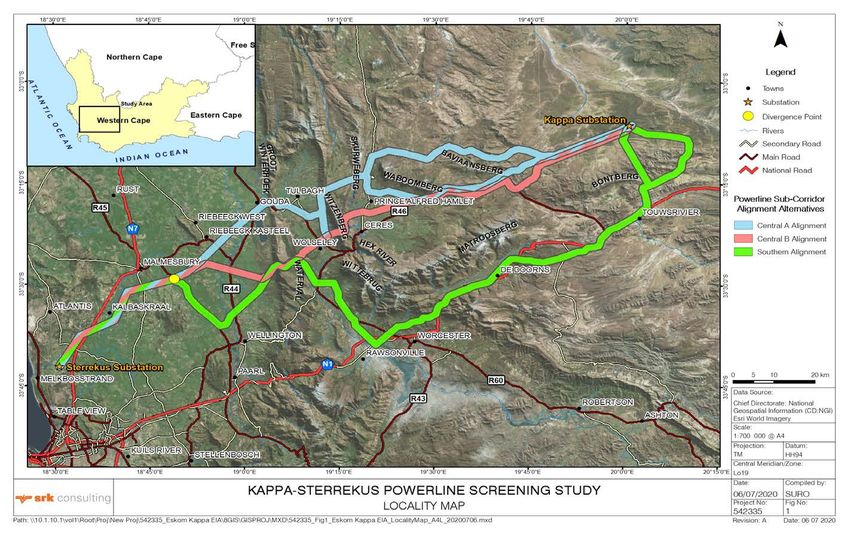
•! Screen!(evaluate)!the!three!sub&corridor!alignment!alternatives!(identified!by!Eskom!–!see!Figure*
1)!based!on!environmental!and!social!factors,!taking!cognisance!of!technical!constraints,!to!select!
a!preferred!alignment\!
•! Identify! the! preferred! sub&corridor! alignment! from! an! environmental,! social! and! technical!
perspective!(the!Screening!Phase)\!and!!
•! Compile! a! detailed! baseline! description! and! identify! preliminary! high&level! sensitivity! of! the!
preferred!alignment,!focusing!on!areas!of!concern!(areas!of!high!or!very!high!sensitivity!that!cannot!
be!avoided!by!infrastructure!placement)!(the!Baseline!Assessment!Phase).!
SRK! appointed! Agriexpert! CC! to! undertake! the! Agricultural! Potential! Screening! study! required! to!
inform! this! environmental! study.!This! report! presents!the! findings! of! the! agricultural! potential! study!
during!the!Screening!Phase!and!will!inform!the!consolidated!Screening!Report!to!be!complied!by!SRK.!
1.1* Project*Background*
1.1.1* Background*
Currently,!Koeberg!Nuclear!Power!Station!is!the!only!base!load!power!station!in!the!Western!Cape\!
however,! it! has! insufficient! capacity! to! meet! local! demand.! ! To! offset! this! deficit,! electricity! is!
transmitted!from!the!Highveld!to!the!Cape!via!the!Cape!(Transmission)!Corridor.!
Despite! improvements! to! the! Corridor! (including! the! 1st! Kappa! –! Sterrekus! [Omega]! line!
commissioned!in!December!2016),!supply!is!constrained!during!peak!periods.!To!increase!capacity,!
reduce!operational!costs,!and!improve!flexibility!and!reliability,!Eskom!must!improve!capacity!to!the!
Cape!Corridor,!which!includes!the!construction!of!the!2nd!Kappa!–!Sterrekus!765!kV!line!(the!Project),!
by!2027.!!
The! Cape! Corridor! falls! within! the! Central! Corridor! identified! through! the! Strategic! Environmental!
Assessment!(SEA)!for!Power!Corridors!(see!Section!1.1.2).!!The!three!sub&corridor!alignments!were!
selected!by!Eskom!based!on!their!technical!feasibility!and!fall!wholly!within!the!Cape!Corridor!(Figure!
1).!
1!
!
Kappa$%Sterrekus%Powerline%Specialist%Screening%Report:%Agricultural%Potential%Assessment%        %

                                                                                             !
         Figure!1:!Powerline!sub1corridor!alignment!alternatives!

                                                                                             %
                                                                                             2%
Kappa$%Sterrekus%Powerline%Specialist%Screening%Report:%Agricultural%Potential%Assessment%                                 %

1.1.2$ Strategic$Environmental$Assessment$for$Power$Corridors$
         To% inform% a% strategic% approach% to% the% planning% and% assessment% of% essential% transmission% grid%
         infrastructure%in%South%Africa,%the%(former)%Department%of%Environmental%Affairs%(DEA),%in%collaboration%
         with% Eskom,% commissioned% a% Strategic% Environmental% Assessment% (SEA),% of% Electricity% Grid%
         Infrastructure.%%The%SEA%identified%five%national%Power%Corridors%specifically%intended%to%accommodate%
         electricity% grid% infrastructure,% which% Cabinet% approved% as% Strategic% Transmission% Corridors% on% 17%
         February%2017.%%The%study%areas%fall%wholly%within%a%Strategic%Transmission%Corridor.%

         Key%outcomes%of%the%SEA%were:%%

         •%   Identification% of% sensitivity$ features% and% sensitivity$ maps$ for% the% Strategic% Transmission%
              Corridors%under%the%following%themes%applicable%to%this%study:%

                 o% Agriculture$

         •%   A$Procedure%for%Electricity%Grid%Infrastructure%Environmental%Assessment%Applications%inside%the%
              Power% Corridors,% to% streamline% and% better% coordinate% environmental% assessment% of% grid%
              infrastructure%within%strategic%corridors,%while%ensuring%environmental%protection.%%

         The%procedure%consists%of%four%phases,%the%first%of%which%is%the%Screening$Phase,%followed%by%more%
         detailed%assessment%in%the%preferred%sub$corridor%alternative,%landowner%negotiations%and%applications%
         for% the% required% approvals.% The% approach% to% screening% has% been% closely% guided% by% the% protocols%
         presented%in%the%SEA.%

1.2$ Objectives$of$the$Agricultural$Potential$Assessment$
     Screening$Report$
         In%broad%terms,%and%based%on%the%protocols%defined%in%the%SEA,%the%objectives%of%this%Screening%Study%
         are%to:%

         •%   Verify% /% validate% and% supplement% or% update% features% that% have% been% identified% as% being% of% low,%
              medium,%high%and%very%high%agricultural%sensitivity%in%the%SEAS%

         •%   Confirm%the%sensitivity%of%features%identifiedS%%

         •%   Compile%a%Screening%Report,%including%a%broad%description%of%the%baseline%characteristics%of%each%
              sub$corridor%alternativeS%and%

         •%   Identify%the%preferred%sub$corridor%alternative%in%consultation%with%SRK%and%Eskom.%

         The%main%outcomes%of%the%Agricultural%Potential%Screening%Study%are%updated%GIS%based%sensitivity%
         layers%to%be%used%by%SRK%in%overall%sub$corridor%screening,%and%a%brief%Screening%Report%(this%report)%
         describing%the%project,%approach%and%method%applied%for%screening,%a%broad%description% of%baseline%
         characteristics,%focusing%on%particularly%sensitive%features%to%the%development%of%powerlines.%

                                                                 3%
                                                                  %
Kappa$%Sterrekus%Powerline%Specialist%Screening%Report:%Agricultural%Potential%Assessment%                                 %

1.3$ Terms$ of$ Reference$ for$ Agricultural$ Potential$
     Assessment$Study$
         The%Terms%of%Reference%(ToR)%for%the%Agricultural%Potential%Screening%Study%are%as%follows:%

         •%   Review%and%update%the%locations%and%extents%of%features%provided%by%SRK%(guided%by%the%approach%
              to%the%SEA)%and$provide$SRK$with$updated$GIS$based$feature$layers%(in%.kmz%file%format)S%

         •%   Confirm%or%update%sensitivity%of%features%(refer%to%the%SEA%–%the%approach%taken%to%determine%the%
              sensitivity%of%features%should%emulate%the%approach%taken%in%the%SEA%unless%specific%motivating%
              circumstances% are% identified% by%the% specialist)% and% advise% on% any% amended% or% additional% buffer%
              zones%requiredS%

         •%   Compile%a%Screening%Report%(this%report),%including:%%

                   !%   Sensitivity%maps%(compiled$by$SRK$based$on$the$verified$location$and$sensitivity$of$
                        features$provided$by$specialists)I%%

                   !%   A%broad%description%of%the%baseline%characteristics%of%each%corridor%alternative%(i.e.%a%broad%
                        description%of%land%use%/%baseline%characteristics%of%each%alternative,%as%well%as%particularly%
                        sensitive%or%important%features,%to%inform%the%chapter%of%the%main%Screening%Report%relative%
                        to%your%field%of%study)S%and%

                   !%   Site$ (corridor)$ Selection$ Matrix$ comparing$ the$ three$ corridors$ and$ selecting$ the$
                        preferred$corridor$alternative$(informed$by$the$specialist$integration$workshop$held$
                        in$Cape$Town,$in$a$format$to$be$determined).$

         •%   Confirm%the%preferred%corridor%alternative%in%consultation%with%Eskom,%taking%into%account%inputs%
              received%during%stakeholder%engagementS%and%

         •%   Provide% responses% and% if% necessary,% update% the% Screening% Report% in% response% to% stakeholder%
              comments.%%

2$       Project$Description$
         The%project%will%entail%the%following:%

         •%   Constructing%the%2nd%765%kV%transmission%powerline%from%the%Kappa%Substation%±25%km%north%of%
              Touws% River,% over% the% Skurweberge% Mountain% Range% to% the% Sterrekus% Substation% near% the%
              Koeberg%Power%Station.%

         •%   Expanding%and%upgrading%both%the%Kappa%and%Sterrekus%SubstationsS%and%

         •%   Conducting%ongoing%maintenance%of%the%powerline.%

         765kV% powerlines% are% the% highest% capacity% lines% used%by% Eskom% and% require% 80% m% wide% servitudes%
         (40%m% on% either% side% of% the% centre% line).% Within% the% servitude,% Eskom% will% have% access% to% erect% a%
         transmission%line%along%a%specified%agreed%route,%operate%and%maintain%the%line%and%clear%vegetation%
         that%will%interfere%with%the%operation%of%the%line.%No%permanent%building%structures%are%allowed%within%
         the%80%m%servitude.%

                                                                 4%
                                                                  %
Kappa$%Sterrekus%Powerline%Specialist%Screening%Report:%Agricultural%Potential%Assessment%                                 %

         Tower$Types$

         Towers% for% the% proposed% transmission% powerline% will% be% between% approximately% 35% m% and% 55% m% in%
         height%and%extend%over%a%footprint%area%ranging%from%approximately%15%m%x%15%m%to%100%m%x%37%m,%
         depending%on%the%tower%type%used.%%

         The%distance%between%each%tower%would%be%approximately%500m,%however,%this%will%be%influenced%by%
         the%topography%and%the%need%for%bends%in%the%line%to%remain%within%negotiated%servitudes.%The%actual%
         number%of%towers,%the%type%of%towers%and%other%support%structures%associated%with%the%proposed%power%
         line%would%be%confirmed%following%approval%of%the%proposed%development%and%once%the%final%alignment%
         is%negotiated%with%property%owners.%%

         A%range%of%tower%types%is%likely%to%be%utilised%along%the%length%of%the%powerline,%informed%by%weight,%
         topography,%height,%cost,%and%erection%time.%These%include:%

         •%   Self$supporting%towers.%

         •%   Guyed%V$suspension%towersS%and%

         •%   Guyed%cross%rope%structures.%

         Examples%of%some%765kV%towers%that%Eskom%is%likely%to%use%are%illustrated%below.%

                                                                                                                               %
           SelfOSupporting%                       GuyedOV$suspension%                        Guyed$cross$rope%
         Towers%are%generally%erected%in%three%ways:%

         •%   Cranes:% which% are% generally% an% efficient% method% for% erecting% lattice% and% steel% poles% which% were%
              preassembled%as%a%unit%or%in%sections.%

         •%   Gin%poles:%used%when%tower%heights%and%weights%exceed%the%capacity%of%the%crane%or%where%access%
              to%the%site%is%restricted.%Erection%of%the%structure%is%done%piece%by%piece%or%section%by%sectionS%or%

         •%   Helicopter:%used%when%access%to%the%tower%position%is%constrained.%

                                                                 5%
                                                                  %
Kappa$%Sterrekus%Powerline%Specialist%Screening%Report:%Agricultural%Potential%Assessment%                            %

         Clearance$

         Minimum%clearance%requirements%are%specified%from%buildings,%poles%and%structures%not%forming%part%
         of%the%power%line,%proclaimed%public%roads%and%trees%and%shrubs%as%well%as%minimum%conductor%ground%
         clearance.%%

         An%approximately%8%m%wide%strip%generally%needs%to%be%cleared%of%all%trees%and%shrubs%down%the%centre%
         of% transmission% power% line% servitude% for% stringing% purposes% only.%Minimum% standards% for% vegetation%
         clearance%in%various%situations%(including%follow%up%clearance)%are%specified%by%Eskom.%%

         Access$roads$
         Temporary% access% roads% will% be% required% for% the% construction% vehicles% to% transport% construction%
         equipment%and%workers%to%and%from%tower%position%sites.%Vehicle%access%is%usually%required%along%the%
         entire%length%of%the%servitude%during%both%the%construction%and%operation%/%maintenance%phases%of%the%
         transmission%power%line%life%cycle.%%

         To%reduce%potential%sensitivity%associated%with%the%construction%of%new%access%roads,%existing%roads%
         will% be% used% as% far% as% possible,% where% available.% New% access% roads% will% be% established% during%
         construction%by%vehicle%passage%rather%than%by%grading%or%blading%to%avoid%permanent%removal%of%the%
         existing%vegetation.%%

2.1$ Corridor$Alignments$
         The%following%three%alternative%sub$corridors%alignment%were%identified%by%Eskom’s%Technical%Team%for%
         the%Project%(see%%

         Figure$1)%and%are%the%subject%of%this%Study:%

         •%   The%Central$A$Alignment,%which%is%±195%km%in%lengthS%%

         •%   The%Central$B%Alignment,%which%is%±185%km%in%lengthS%and%

         •%   The%Southern$Alignment,%which%is%±260%km%in%length.%

         The%sub$corridor%runs%in%a%north$easterly%direction%from%the%Sterrekus%substation%near%Melkbosstrand%
         in%the%West%Coast%District%Municipality%towards%the%town%of%Malmesbury,%at%which%point%they%diverge%
         into%the%three%alternative%alignments.%%All%three%alignment%alternatives%converge%and%terminate%at%the%
         Kappa%substation%north%of%Touws%River.!!!

         Central$A$Alignment%(Blue%on%Figure%1)%

         From%the%Divergence%Point%the%Central%A%Alignment%routes%in%a%north$easterly%direction%towards%Gouda%
         (passing% between% Riebeek% Kasteel% and% Hermon).% % The% corridor% tracks% south% from% Gouda% over% the%
         southern%foothills%of%the%Groot%Winterhoek%Mountains%and%the%Winterhoek%Mountain%Catchment%Area,%
         and%then%south%of%Tulbagh%in%the%Witzenberg%Valley%(where%a%southern%tie$in%is%included%here).%%The%
         alignment%then%passes%over%Skurweberg%into%the%Ceres%Valley%where%it%splits%into%two%route%alternatives:%
         the%northern%route%and%the%southern%route.%The%southern%route%passes%south%of%Mountain%7%(and%north%
         of% Prince% Alfred% Hamlet)% and% tracks% eastwards% out% of% the% Ceres% Valley% along% the% R46% road% and%
         Theronsberg%Pass.%%The%northern%route%passes%north%of%Waboomsberg,%over%Baviaansberg,%and%once%

                                                                 6%
                                                                  %
Kappa$%Sterrekus%Powerline%Specialist%Screening%Report:%Agricultural%Potential%Assessment% %
again%merges%with%the%southern%route%west%of%Baviaansberg%in%the%southwestern%Karoo.%%The%alignment%
then%extends%a%further%±23km%to%the%Kappa%Substationin%in%a%north$east%direction..%
Central$B$Alignment%(Red%on%Figure%1)%
From%the%Divergence%Point%the%Central%B%Alignment%tracks%in%a%north$easterly%direction%to%the%south%of%
Hermon%and%over%Waterval%into%the%Breede%River%Valley.%%It%then%routes%north%of%Wolseley%over%the%
Witzenberg%and%Skurweberg%mountains%and%north%of%Ceres%in%the%Ceres%Valley.%%The%alignment%then%
routes%south%of%Waboomsberg%(and%south%of%Prince%Alfred%Hamlet)%and%eastwards%out%of%the%Ceres%
Valley%along%the%R46%road%and%Theronsberg%Pass.%%The%alignment%then%extends%in% a%north$easterly%
direction%for%a%further%±40%km%into%the%southwestern%Karoo,%terminating%at%the%Kappa%Substation%north%
of%Touws%River.%
Southern$Alignment$(Green%on%Figure%1)$
From% the% Divergence% Point,% the% Southern% Alignment% tracks% south% along% the% R45% road% towards%
Wellington,%and%then%north$east%through%the%Haweqwa%Nature%Reserve%over%the%Boland%Mountains%into%
the%Breede%River%Valley.%%It%then%routes%south%through%this%valley%before%tracking%north%(northwest%of%
Worcester%and%the%Brandvlei%Dam)%over%the%Riviersonderend%Mountains%and%through%the%Matroosberg%
Mountain%Catchment%Area%along%the%Hex%River%Pass%into%the%Hex%River%Valley%towards%De%Doorns.%%It%
then%continues%north$east,%roughly%following%the%route%of%the%N1%road,%over%the%Hex%River%Mountains%
towards%Touws%River.%%The%alignment%then%follows%two%alternative%routes%in%a%north%direction%towards%
the%Kappa%Substation.%
3$ Approach$and$Methodology$
3.1$Desktop$Study$
This%study%is%informed%by%the%specialist's%experience%of%conducting%specialist%agricultural%assessments.%
A%desktop%study%was%conducted%including%making%use%of%information%in%the%SEA%and%to%review%existing%
data%and%literature%sources.%The%desktop%review%provided%a%baseline%agricultural%and%land%use%profile,%
focusing%on%the%specific%geographical%area,%potentially%impacted%by%the%proposed%project.%%This%was%
supplemented%by%additional%supporting%data.%Agricultural%sensitivity%is%understood,%for%the%purposes%of%
this%study,%as%any%sensitivity%that%translates%into%reduced%agricultural%production.%This%may%occur%by%
way%of%a%degradation%of%the%agricultural%resource%base%by%way%of%a%direct%disturbance%to%agricultural%
activities% (e.g.% occupation% of% the% site),% or% by% way% of% the% introduction% of% limitations% to% agricultural%
production.%
%
Three%factors%determine%the%significance%of%the%agricultural%sensitivity%of%electricity%grid%infrastructure%
developments.%The%first%is%the%reduction%of%the%agricultural%productivity%of%the%affected%land.%The%second%
is%the%proportion%of%available%land%that%is%affected.%The%third%is%the%degree%of%disturbance%that%will%occur.%
The%significance%of%the%sensitivity%increases%as%the%scale%of%any%or%all%these%factors%increase.%These%
factors%have%been%taken%into%account%in%considering%the%relative%sensitivity%of%agricultural%resources%in%
the%study%area%to%the%proposed%powerline%development.%
%
7%
%Kappa$%Sterrekus%Powerline%Specialist%Screening%Report:%Agricultural%Potential%Assessment% %
A%desktop%survey%was%carried%out%to%assess%the%corridors%in%terms%of%the%potential%impact%of%electricity%
grid%infrastructure%on%agriculture%activities%and%or%potential,%taking%cognizance%of%the%relative%sensitivity%
of% these% areas,% and% outline% proposed% management% actions% with% particular% attention% to%the% following%
aspects:%
•% The%possibility%of%permanent%loss%of%high%potential%agricultural%land.%
•% Impairment%of%land%capability%due%to%construction.%
•% Veld%conditions%for%grazing.%
•% Analysis%of%erosion%risk%because%of%altered%drainage%patterns%and%poor%rehabilitation%in%
erosion$sensitive%areas.%
The%analysis%of%the%three%alternative%corridors%was%done%by%way%of%a%desktop%exercise%using%existing%
data%on%agricultural%land%use%and%land%capability%(See%Table%6%below)%and%information%contained%in%the%
SEA.%The%assessment%was%done%by%identifying%agricultural%features%and%assigning%a%sensitivity%to%each%
of%them.%
%
Agriculture%can%continue%largely%undisturbed%below%powerlines%in%most%cases%due%to%the%relatively%low%
sensitivity%to%electricity%grid%infrastructure%and%because%of%the%actual%footprint%of%impact%is%confined%to%
pylon%bases%and%substations%and%involves%an%extremely%small%proportion%of%the%land%surface.%
The%interpretation%of%each%of%the%agricultural%sensitivity%ratings%as%identified%in%Table%1%are%described%in%
below.%%
Table$1$O$Interpretation$of$Sensitivity%
Sensitivity$ Interpretation$of$Sensitivity$
Potentially%unsuited%to%development%because%it%will%lead%to%loss%of%significant%land%
Very%High%
and%infrastructure%with%existing%high%agricultural%productivity.%
%
Avoid%as%far%as%possible%because%it%will%lead%to%considerable%disturbance%and%
High%
loss%of%existing%or%potential%agricultural%production%and%infrastructure%and%further%
financial%implication%costs.%
%
Relatively%average%impact%on%agriculture%and%infrastructure%because%it%will%lead%to%
Medium%
very%minor%disturbance%and%loss%of%existing%or%potential%agricultural%production%and%
existing%infrastructure%in%place.%%
%
Insignificant%impact%on%agriculture%and%infrastructure.%
Low%%
%
%
%
%
%
%
8%
%Kappa$%Sterrekus%Powerline%Specialist%Screening%Report:%Agricultural%Potential%Assessment% %
%
Agricultural%features%identified,%the%relative%sensitivity%to%development%and%the%motivation%for%each%is%
presented%in%Table%2.%
Table$2:$Sensitivity$Features$
Sensitivity$ Sensitivity$ Motivation$/$Justification$
Feature$
Class$
Pivots% Very%High% The% sensitivity% of% agricultural% pivot% areas% associated% with% the%
development:%
•% Pivot%established%infrastructure%cannot%be%operational%under%live%
powerlines% and% therefore% may% result% in% the% termination% of% the%
agricultural%facility%and%these%features%are%seen%as%high%sensitivity%
features% within% the% corridor.% The% proportion% of% agricultural% land%
affected% under% pivot% irrigation% will% be% severe% as% the% powerlines%
direct% impact% on% the% ground% will% ensure% that% an% entire% pivot%
irrigation% field% will% be% affected% if% the% proposed% route% will% run%
through% such% an% area,% because%the% pivot% will% not% be% able% to% be%
operational.% The% level% of% disturbance% will% also% be% significant% as%
pivot% irrigation% practises% cannot% continue% under% the% proposed%
powerline%development.%%
•% Loss% of% agricultural% land% under% pivot% irrigation% caused%by% direct%
occupation% of% land% by% footprint% of% powerline% infrastructure.% This%
takes% affected% portions% of% land% (irrigated% under% pivots% )% out% of%
agricultural%production,.%
•% Disturbance% to% agricultural% practices% and% management% during%
construction%in%close%proximity%of%pivots.%
Agricultural% Very%High% •% Agricultural%buildings%should%be%avoided%as%far%as%possible%as%the%
Buildings%% proposed% powerline% cannot% be% constructed% over% established%
buildings.%
•% Buildings% are% not% allowed% within% the% powerline% servitude,% thus%
areas%comprising%of%any%buildings%that%will%be%left%in%place%cannot%
form%part%of%the%Eskom%servitude%area.%%
Viticulture% High% •% Viticulture% land% parcels% that% are% of% >400% m% in% extent% will% be%
>400%m% negatively%affected%by%the%proposed%powerline%as%small%areas%at%
tower%positions%will%be%terminated%because%tower%spans%cannot%
clear%areas%>400%m%in%extent.%These%features%are%evaluated%as%
being%of%high%sensitivity%as%areas%including%viticulture%>400%m%in%
9%
%Kappa$%Sterrekus%Powerline%Specialist%Screening%Report:%Agricultural%Potential%Assessment% %
Sensitivity$ Sensitivity$ Motivation$/$Justification$
Feature$
Class$
extent%is%found%within%the%servitude%however,%these%areas%are%not%
seen% as% fatal% flaw% areas% as% the% powerline% footprint% will% have% a%
small% negative% impact% in% these% areas% due% to% the% small% area%
affected%by%powerline%infrastructures.%
Vines%>400% High% •% Vines%land%parcels%that%are%of%>400%m%in%extent%will%be%negatively%
m% affected% by% the% proposed% powerline% as% small% areas% at% tower%
positions% will% be% terminated% because% tower% spans% cannot% clear%
areas%>400%m%in%extent.%These%features%are%evaluated%as%being%
of% high% sensitivity% as% areas% including% vines% >400% m% in%extent% is%
found%within%the%servitude%however,%these%areas%are%not%seen%as%
fatal% flaw% areas% as% the% powerline% footprint% will% have% a% small%
negative%impact%in%these%areas%due%to%the%small%area%affected%by%
powerline%infrastructures.%
Horticulture% High% •% Horticulture% land% parcels% that% are% of% >400% m% in% extent% will% be%
>400%m% negatively%affected%by%the%proposed%powerline%as%small%areas%at%
tower%positions%will%be%terminated%because%tower%spans%cannot%
clear%areas%>400%m%in%extent.%These%features%are%evaluated%as%
being%of%high%sensitivity%as%areas%including%horticulture%>400%m%in%
extent%is%found%within%the%servitude%however,%these%areas%are%not%
seen% as% fatal% flaw% areas% as% the% powerline% footprint% will% have% a%
small% negative% impact% in% these% areas% due% to% the% small% area%
affected%by%powerline%infrastructures.%
Yields% High% •% Yield%land%parcels%that%are%of%>400%m%in%extent%will%be%negatively%
under% affected% by% the% proposed% powerline% as% small% areas% at% tower%
Shade% positions% will% be% terminated% because% tower% spans% cannot% clear%
Netting% areas%>400%m%in%extent.%These%features%are%evaluated%as%being%
of%high%sensitivity%as%areas%including%yields%>400%m%in%extent%is%
found%within%the%servitude%however,%these%areas%are%not%seen%as%
fatal% flaw% areas% as% the% powerline% footprint% will% have% a% small%
negative%impact%in%these%areas%due%to%the%small%area%affected%by%
powerline%infrastructures.%
Land% High% •% Areas%including%Land%capability%class%11%are%found%in%the%corridor%
capability% and%areas%will%be%negatively%affected%by%the%proposed%powerline%
Class%11%% as%tower%footprint%positions%will%be%terminated.%
10%
%Kappa$%Sterrekus%Powerline%Specialist%Screening%Report:%Agricultural%Potential%Assessment% %
Sensitivity$ Sensitivity$ Motivation$/$Justification$
Feature$
Class$
•% These% features% are% evaluated% as% being% of% high% sensitivity% as%
areas%of%this%class%are%highly%valuable%agricultural%land.%However,%
these% areas% are% not% seen% as% fatal% flaw% areas% as% the% powerline%
footprint%will%have%a%small%negative%impact%in%these%areas%due%to%
the%small%area%affected%by%powerline%infrastructures.%
Land% Medium% •% These% features% are% found% within% this% proposed% corridor% but% are%
Capability% not%seen%as%fatal%flaw%areas%because%land%capability%classes%5%to%
Class% 9% &% 10%consist%of%agricultural%land%with%a%lower%agricultural%production%
10%% value.%
Land% Low%% •% These% features% are% found% within% this% proposed% corridor% but% are%
not%seen%as%areas%of%concern.%
Capability%
5,6,7,8%
!
!
3.1$Data$Sources$
The%data%sources%used%in%identifying%agricultural%features%to%which%sensitivity%ratings%were%allocated%are%
listed%in%Table%3.%
Table$3:$Data$Sources%
Sensitivity%Feature%Class% Data%Source% Data%Description%
Field%crop%boundaries% DAFF,%2013.% Delineates% the% boundaries% of% all%
% Land%cover,% cultivated% land,% based% on% satellite% and%
DEADP,% aerial% imagery.% Seven% different%
2014.% categories% of% cultivated% land% are%
distinguished.%These%activities%include%
horticulture/viticultureS%shade%netS%annual%
crop% cultivation/planted% pastures%
rotationS%old%fieldsS%subsistence%farmingS%
small%holdings.%
Grazing%Capacity%(2018)% Cape% Farm% Categorises%all%land%nationally%in%different%
Wine%of%Origin%Districts% Mapper% classes%of%agricultural%land%and%potential.%
Land%Cover%(DEA,%2018)%
Soils%&%Geology%(ENPAT)%
Slope%(Degree)%
11%
%Kappa$%Sterrekus%Powerline%Specialist%Screening%Report:%Agricultural%Potential%Assessment% %
Sensitivity%Feature%Class% Data%Source% Data%Description%
Water%Management%Areas%
VegMap%2018%(Beta)%
Soil%Types%
Land%Types%
Soil%Erodibility%
Veld%Types%(Acocks)%
Biomes%(Low%Rebelo)%
Soil%Clay%&%Depth%
Land%capability% Land% Categorizes%all%land%nationally%in%different%
Class%1$15% capability,% classes% of% agricultural% land% capability.%
% DAFF,% The%classification%is%based%on%soil%terrain,%
2016% terrain%and%climate%parameters.%
All%other%cultivated% Field% crop% Delineates% the% boundaries% of% all%
fields% boundaries,% cultivated% land,% based% on% satellite%
DAFF,%2013.% imagery%and%aerial%imagery.%
%
Land%cover% DEA&DP% Raster% data% indicating% viticulture% as% a%
2014.% land%cover%category.%
Grazing%capacity%Potential%% DAFF,2016% Mapped% categories%for%grazing% capacity%
potential% across% the% study% area.% This% in%
nor% gazetted% grazing% capacity% under%
CARA%but%acts%as%a%guideline.%
$
3.2$$ASSUMPTIONS$AND$UNCERTAINTIES$
The%study%uses%only%existing%data,%which%as%noted%above,%has%limited%resolution.%Fieldwork%was%not%
considered%necessary%at%this%stage%of%the%screening%phase%as%limited%information%obtained%would%not%
add% significantly% to% this% screening% study.% Climatic% conditions,% land% uses,% land% type% and% terrain% are%
readily%available%from%literature,%GIS%information%and%satellite%imagery.%
4$ Baseline$Characteristics$of$the$Project$Area$$
Each%alternative%corridor%is%±2%km%wide,%resulting%in%a%vast%study%area%of%±1%200%km2.%
The%climate%of%the%study%area%varies%from%Mediterranean%in%the%low$lying%southwest,%to%semi$arid%in%the%
northeast.% The% powerline% will% traverse% a% diverse% environment,% which% includes% natural% areas,% and%
agricultural,%residential,%commercial,%industrial%and%conservation%land%uses.%%
12%
%Kappa$%Sterrekus%Powerline%Specialist%Screening%Report:%Agricultural%Potential%Assessment% %
The%project%traverses%the%City%of%Cape%Town,%West%Coast%and%Cape%Winelands%District%Municipalities,%
and%is%located%entirely%in%the%Western%Cape%Province.%
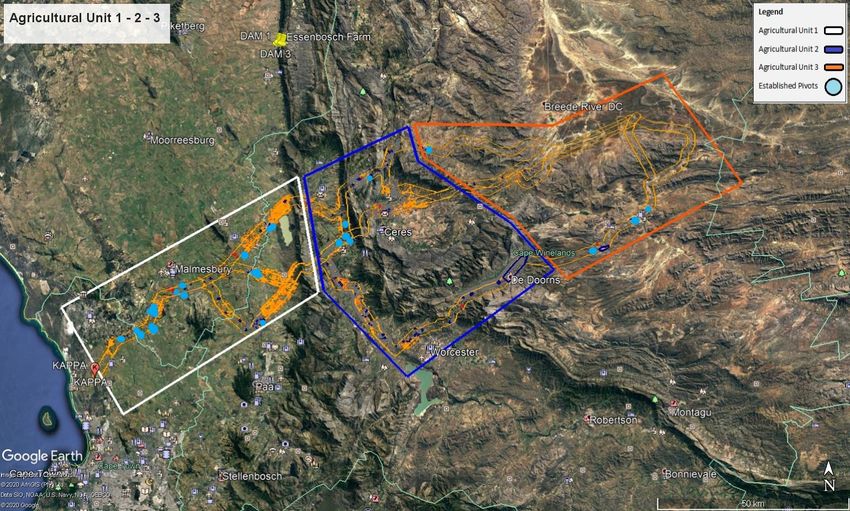
The%study%can%be%divided%into%three%main%agricultural%units%(Figure%2),%as%follows:%
•% Agricultural$Unit$1:$Identified%area%in%the%white%block.%
•% Agricultural$Unit$2:$Identified%area%in%the%blue%block.$
•% Agricultural$Unit$3:%Identified%area%in%the%orange%block.
13%
%Kappa$%Sterrekus%Powerline%Specialist%Screening%Report:%Agricultural%Potential%Assessment% %
!
Figure!2:!Powerline!Sub1Region!Overview!–!Agricultural!Units!11213.
%
14%Kappa$%Sterrekus%Powerline%Specialist%Screening%Report:%Agricultural%Potential%Assessment% %
4.1$Corridor$Sub-Region$Overview$
$$$$$$$$$Central$Alignments$A$&$B$$
Central%Alignments%A%&%B%follow%a%similar%route%that%comprise%of%comparable%environmental%features%
and%are%evaluated%below.%
Agricultural$Unit$1$is#defined#as#the#area#that#stretches#from#the#Sterrekus#substation#at#the#
starting#point#near#Melkbosstrand#to#the#Winterhoek#Mountains#in#a#north8easterly#direction#towards#
the#Kappa#Substation#(See%figure%2).$
Baseline$Info$
The% current% baseline% agricultural% site% activities% applicable% with% the% Central% A% &% B% Alignments% of% the%
proposed% powerline% alternative% are% restricted% to% mainly% grain% farms% in% unit% 1% from% the% Sterrekus%
Substation%towards%the%town%of%Gouda%with%some%scattered%established%viticulture%production%farms%in%
the%area%of%Malmesbury.%This%area%includes%the%production%of%various%grains%including,%wheat,%maize%
and%canola%yields%including%yield%production%under%irrigation%pivots.%%%%
Topography$$
Due%to%the%area’s%relatively%flat%topography%in%unit%1%of%the%Alignment%and%fertile%soils%in%close%proximity%
to%Cape%Town,%the%Swartland%became%established%as% a%wheat$growing%area%around%the%mid$1700s.%
While%the%region%encompasses%patches%of%fynbos,%the%predominant%vegetation%type%in%the%Swartland%
was%historically%Renosterveld%–%an%evergreen%shrubland%which%mainly%comprises%species%in%the%daisy%
family% with% a% wealth% of% grasses,% annuals,% herbaceous% perennials,% and% an% extraordinary% array% of%
geophytes.%%
Climate$
Agriculture%is%highly%dependent%on%climatic%conditions%to%ensure%sustainable%farming%in%the%Western%
Cape.%The%proposed%powerline%corridors%start%near%Melkbosstrand%along%the%West%Coast.%This%area%
has%a%Mediterranean%habitat%and%normally%receives%about%318%mm%of%rain%per%year%and%during%winter.%
The%area%receives%the%lowest%rainfall%(4%mm)%in%February%and%the%highest%(59%mm)%in%July.%The%monthly%
distribution%of%average%daily%maximum%temperatures%shows%that%the%average%midday%temperatures%for%
area%range%from%16°C%in%July%to%27°C%in%February.%%
The%region%is%the%coldest%during%July%when%the%mercury%drops%to%7.5°C%on%average%during%the%night.%
Due%to%the%climate%conditions%throughout%this%area,%agricultural%activities%are%sustainably%practised.%
The%proposed%powerline%alternatives%then%divert%inland%past%Malmesbury.%Malmesbury%lies%at%135%m%
above%sea%level..%The%average%day%and%night%combined%temperature%in%the%area%is%17.1%°C.%Various%
sustainable%agriculture%activities%such%as%vine%plantations%and%other%cultivated%practises%are%performed%
throughout%this%area%which%make%the%surrounding%area%as%a%high%agricultural%potential%area.%
$
15%
%Kappa$%Sterrekus%Powerline%Specialist%Screening%Report:%Agricultural%Potential%Assessment% %
Geology$and$Soils$
Chemically%weathered,%deeper%soil%profiles%are%found%in%the%wetter%coastal%areas%of%the%province%where%
the%proposed%powerline%will%be%established,%while%the%dry%interior%soils%have%shallow,%poorly%formed%soil%
profiles.%
The%West%Coast%is%dominated%by%soils%that%are%created%through%wind%erosion%(i.e.%windblown%sands).%
These%soils%are%incredibly%susceptible%to%wind%erosion,%which%is%exacerbated%by%vegetation%loss%due%to%
anthropogenic%activities%and%desertification.%
Inland%from%this,%soils%are%typically%clay$based%and%derived%from%the%weathering%of%Malmesbury%shale%
substrates,%as%such%making%them%perfect%for%winter%wheat%farming.%High%lying%soils%(600%m%and%above)%
experience%high%winter%rainfall,%which%results%in%acidic%sands%with%high%organic%value.%Colluvial%slopes,%
which%are%deeper%and%underlain%by%shale%or%granite,%are%less%acidic%and%nutrient%rich.%Young%sands%on%
the%coastal%margin%are%highly%alkaline.%The%dominant%soil%type%in%Swartland%is%Malmesbury%can%be%best%
described%to%consist%of%high%alkaline%formations.%
Pivots$$
Pivot%irrigation%(also%called%central%pivot%irrigation)%is%a%method%of%crop%irrigation%in%which%equipment%
rotates%around%a%pivot%infrastructure%and%crop%fields%are%watered%with%sprinklers.%
A%total%of%17%established%agricultural%pivots%are%found%within%the%2%km%wide%Central%Alignment%of%this%
proposed%powerline%development%Alignment%A%&%B%in%unit%1%(Refer%to%figure%3%below).%Most%of%these%
pivots%are%found%in%the%first%third%of%the%overall%powerline%in%which%grain%farming%is%practised%and%irrigated%
between%Melkbosstrand%and%Gouda.%%
These%established%pivots%are%identified%as%an%area%of%particular%concern%but%are%also%distributed%over%a%
large% area% and% can% be% avoided% when% the% powerline% route% is% designed% without% any% significant%
implications.%Further%scattered%and%individual%pivots%are%found%in%sections%of%unit%1%and%2%of%the%rest%of%
the%powerline%and%are%mostly%situated%on%the%side%of%the%2%km%wide%corridor%and%can%be%avoided%through%
proper%planning.%
Pivot&positions:#
$%%%%%1%Pivot%$%(33°36'34.47"S%/%18°35'7.20"E)%
$% 2%Pivots%$%(33°35'53.98"S%/%18°37'21.51"E)%%
$% 2%Pivots%$%(33°35'39.54"S%/%18°39'24.18"E)%
$% 3%Pivots%$%(33°33'40.25"S%/%18°39'43.67"E)%
$% 2%Pivots%$%(33°30'55.50"S%/%18°44'11.09"E)%
$% 1%Pivot%–%(33°29'53.62"S%/%18°44'53.62"E)%
$% 1%Pivot%–%(33°25'9.97"S%/%18°55'32.94"E)%
$% 2%Pivot%–%(33°21'42.07"S/%18°59'22.34"E)%
$% 1%Pivot%–%(33°27'59.57"S/%18°56'58.00"E)%
$% 2%Pivot%–%(33°28'8.74"S/%18°57'17.44"E).%
16%
%Kappa$%Sterrekus%Powerline%Specialist%Screening%Report:%Agricultural%Potential%Assessment% %
%Figure'3:'Established'Pivot'Infrastructure'in'place'–'See'Report'for'Coordinate'Points'
%
17%Kappa$%Sterrekus%Powerline%Specialist%Screening%Report:%Agricultural%Potential%Assessment% %
Agricultural*Buildings*
Various%scattered%agricultural%homesteads%and%buildings%are%found%in%the%vicinity%of%unit%1%of%the%corridor%
as% it% passes% through% various% properties% due% the% extent% of% the% powerline% development.% Very% few%
agricultural%buildings%are%found%in%unit%1%of%the%corridor%and%will%not%significantly%affect%the%powerline%
route%within%the%2%km%wide%corridor.%Several%large%linear%buildings%(chicken%broilers)%are%found%in%the%
middle%of%the%corridor%(33°36'43.48"S*/*18°35'59.12"E)%near%Malmesbury%and%should%be%considered%as%
an%area%of%particular%concern%during%the%route%planning%phase.%This%section%can%pose%a%great%risk%when%
the% powerline% is% designed.% Further% isolated% agricultural% buildings% are% located% within% the% 2% km% wide%
servitude% from% the% town% of% Malmesbury% towards% the% Winterhoek% Mountains,% but% these% identified%
buildings%are%isolated%and%cover%small%areas.*
Shade*Netting*
Very%few%and%small%agricultural%practises%that%include%shade%netting%are%found%in%unit%1%of%the%corridor%
as%most%activities%include%dryland%grain%farming.%%
The% first% area% established% under% netting% infrastructure% is% found% before% the% town% of% Riebeek% West%
(33°25'28.68"S*/*18°54'1.66"E)%and%is%located%across%the%2%km%wide%corridor%and%covers%an%area%of%
45.5%hectares%and%should%be%considered%in%identifying%the%powerline%route.%A%second%area%established%
under% netting% infrastructure% is% found% near% the% centre% of% the% 2% km% wide% corridor% (33°25'57.82"S/*
18°54'19.26"E)%and%covers%an%area%of%approximately%8.5%hectares,%although%relatively%a%small%area,%
this%feature%must%be%considered%during%the%route%plan%but%are%not%identified%as%high$risk%areas.%
Viticulture*/*Vines*&*Horticulture*production*
The%agricultural%practises%inform%part%of%this%corridor%and%are%practised%in%various%locations%across%the%
study%area.%The%first%production%area%for%these%practises%is%found%in%unit%1%in%close%proximity%to%the%town%
of% Malmesbury% (33°31'22.88"S* /* 18°41'9.37"E* to* 33°29'42.21"S* /* 18°47'46.66"E)% where% scattered%
pieces% of% developed/established% viticulture,% vine% and% horticulture% land% are%found.%These% parcels% are%
mostly%small%in%size%and%cover%an%area%less%than%400%meters%in%length%and%it%would%not%propose%a%great%
risk%to%the%route%plan%in%this%area.%%The%next%two%areas%of%agricultural%land%are%found%within%the%corridor%
just% south% of% the% town% of% Riebeek% Kasteel% (33°24'2.42"S* /* 18°55'28.17"E)% as% well% as% at% in% the% area%
between% Riebeek% Kasteel% and% Gouda% (33°21'11.61"S/* 18°59'4.95"E).%These% parcels% are% all% divided%
into%small%portions%and%cover%areas%less%than%400%meter%in%length.%%
The%next%area%is%found%within%the%corridor%in%unit%1%at%the%deviation%point%where%Central%B%%Alignment%
diverts% to% the% east% and% stretches% for% about% 6% km% (33°27'11.22"S/* 18°54'21.40"E* to* 33°28'23.43"S* /%
18°58'22.50"E).%These%land%parcels%are%all%divided%into%small%portions%and%cover%areas%less%than%400%
meter% in% length% and% are% scattered% over% the% distance% and% should% not% pose% a% great% impact% on% the%
powerline%route.%
Land*capability**
No%land%capability%class%11%–%15%areas%(high%sensitivity%–%see%Table%3)%are%found%in%unit%1%of%this%corridor.%
Land%capability%classes%9%&%10%are%considered%to%be%of%Medium%sensitivity%and%will%not%pose%a%risk%to%
the%proposed%development%due%to%its%sensitivity.%As%the%powerline%footprint%is%very%small%it%should%not%
18%
%Kappa$%Sterrekus%Powerline%Specialist%Screening%Report:%Agricultural%Potential%Assessment% %
pose%a%great%impact%to%agricultural%activities%practised%in%these%areas%and%this%feature%is%not%considered%
as%a%high%risk.%%
Agricultural*Unit*2*is*defined*as*the*area*that*stretches*from*the*Winterhoek*Mountains*in*a*
northEeasterly*direction*to*the*south*of*the*town*of*Tulbagh*in*the*Witzenberg*Valley*(*a*southern*tieE
in*is*included*here)*where*Central*Alignment*A*&*B*then*passes*over*Skurweberg*into*the*Ceres*Valley*
where*it*splits*into*two*route*alternatives:*the*northern*route*and*the*southern*route.*
Baseline*Info*
Central%Alignment%A%%continues%into%agricultural%unit%2%past%the%town%of%Gouda%towards%Tulbagh%that%is%
situated% towards% the% north% of% the% corridor% where% further% dryland% agricultural% farming% is% practised%
including%different%grain%crops%and%horticulture%production,%this%section%of%the%corridor%will%not%have%a%
large%impact%to%agricultural%practises%in%the%area.%%
Central%Alignment%A%then%deviates%north%and%crosses%the%mountains%towards%the%east%of%the%town%of%
Tulbagh% where% not% any% agricultural% practises% are%found% due% to% the% landscape% characteristics% in% this%
area.% A% high% concentration% of% agricultural% activities% is% found% in% the% area% between% (33°15'54.78"S* /*
19°13'25.16"E% to% 33°14'34.10"S* /* 19°16'50.70"E)% and% consist% mostly% of% viticulture% and% horticulture%
farming%(Kappa$%Sterrekus%Powerline%Specialist%Screening%Report:%Agricultural%Potential%Assessment% %
The%winter%months%are%much%rainier%than%the%summer%months.%The%average%temperature%in%this%area%
is%17.2%°C.%The%annual%rainfall%is%400%mm.%Various%sustainable%agriculture%activities%such%as%vineyards%
are%found%through%this%section%with%high%potential%agricultural%land%in%places%across%this%agricultural%unit%
2.%
Geology*and*Soils*
Soils%that%have%a%low%potential%for%agricultural%development%are%found%on%the%mountain%range%areas%
with%hard%and%weathering%rock%in%these%areas%of%agricultural%unit%2%Glenrosa%and/or%Mispah%forms%(other%
soils% may% occur)% are% in% the% landscape% area.% Phyllite% shale,% schist% and% greywacke% of% the% Porterville%
Formation,%Malmesbury%Group,%partly%covered%by%talus%gravel%are%also%present.%
Pivots*
A% total% of% 5% established% agricultural% pivots% are% found% within% the% 2% km% wide% corridor% of%this% proposed%
powerline%development%for%Alignments%A%&%B%in%unit%2%(Refer%to%Figure%3).%%%%
Three%of%these%established%pivots%are%situated%directly%north%of%Wolsely%and%are%identified%as%areas%of%
concern%but%can%be%avoided%when%the%powerline%route%is%planned.%A%further%two%scattered%and%individual%
pivots%are%found%in%sections%of%unit%2%the%of%this%Alignment%%and%are%mostly%situated%on%the%side%of%the%
2%km%wide%corridor%and%will%most%likely%not%pose%any%influence%on%the%powerline%route%design.%
Pivot%positions:%
$%%%%%%%1%Pivot%$%(33°24'3.42"S/%33°24'3.42"S)%
$%%%%%%%2%Pivot%$%(33°23'46.72"S/%19°11'31.87"E)%
$%%%%%%%1%Pivot%$%(33°21'33.57"S/%19°12'10.73"E)%
$%%%%%%%1%Pivot%$%(33°14'20.56"S/%19°16'5.24"E)%
Agricultural*Buildings*
2% Agricultural% Irrigation% Pivots% $% are% situated% just% north% of% the% town% of% Wolseley% (33°23'54.24"S% /%
19°11'5.92"E)% in% close% proximity% to% another% and% stretch% across% the% 2% km% wide% servitude% with% an%
agricultural%homestead%positioned%in%close%vicinity%to%the%pivots.%These%fixtures%limit%the%space%available%
in%this%section%for%the%powerline%to%pass%through%and%are%considered%as%an%area%of%particular%concern.%%
Viticulture*/*Vines*&*Horticulture*production*
The%corridor%%continues%the%Winterhoek%mountain%range%towards%the%east%of%the%town%of%Tulbagh%where%
no%sensitive%agricultural%features%are%found.%A%small%section%of%horticulture%production%is%practised%just%
before% the% town% of% Tulbagh% (33°18'11.41"S% /% 19°% 6'14.81"E)% and% after% Tulbagh% ((33°18'43.38"S% /%
19°11'55.76"E)%(See%figure%4)).%The%identified%horticulture%land%parcels%are%positioned%in%the%centre%of%
the% corridor% but% are% small% in% size% and% stretch% over% an% area% of% less% than% 400% meter% in% length.%
Subsequently%a%section%of%5%km%of%concentrated%agricultural%land%parcels%are%established%from%the%foot%
of%the%mountain%range%(33°15'51.76"S%/%19°13'49.19"E%to%33°14'29.07"S%/%19°16'47.47"E).%This%section%
includes%various%horticulture%plantations%(including%citrus%plantations).%The%corridor%further%continues%%
20%
%Kappa$%Sterrekus%Powerline%Specialist%Screening%Report:%Agricultural%Potential%Assessment% %
across%the%Winterhoek%mountain%range%towards%the%east%where%not%any%sensitive%agricultural%features%
are%found.%%
Shade*Netting*
A%netting%infrastructure%establishment%of%approximately%1.5%hectares%situated%at%%in%the%area%between%
Gouda%and%Tulbagh%(33°18'17.42"S%/%19°%5'55.44"E)%is%found%near%the%centre%of%the%2%km%wide%Central%%
Alignment%B%but%the%area%in%mention%is%very%small%and%should%not%pose%great%risk%to%the%powerline%route%
plan.%
A%second%netting%infrastructure%establishment%of%approximately%14.5%hectares%situated%at%in%the%area%
just%north%of%the%Bella%Vista%residential%area%(33°18'54.16"S/*19°18'19.92"E)%is%also%situated%within%the%
Alignment.%The%netting%infrastructure%is%positioned%on%the%side%of%the%2%km%wide%Central%Alignment%B%
and%will%not%have%an%impact%on%the%powerline%route.%The%portion%of%agricultural%land%with%established%
shade%netting%infrastructure%in%place%will%not%be%greatly%affected%as%the%powerlines%direct%impact%on%the%
ground%through%strategic%pylons%will%be%a%very%small.%
Land*capability**
No%land%capability%class%11%$15%areas%are%found%within%unit%2.%Land%capability%classes%9%&10%are%found%
but%is%evaluated%as%medium%sensitivity%and%will%not%pose%a%risk%to%the%proposed%development.%As%the%
powerline%footprint%is%small%it%should%not%pose%a%great%impact%to%agricultural%activities%practised%in%these%
areas.%%%
Agricultural* Unit* 3* is* defined* as* the* area* that* stretches* from* the* Waboomsberg,* over*
Baviaansberg,* and* once* again* merges* with* the* southern* route* west* of* Baviaansberg* in* the*
southwestern* Karoo* where* the* alignment* extends* a* further* ±23km* to* the* Kappa* Substation* to* the*
northEeast.*
Baseline*Info*
Alignments%A%&%B%divert%towards%the%east%into%unit%3%for%the%last%70%km%where%very%little%agricultural%
practises%are%found%that%will%be%negatively%affected%due%the%powerline%crossing%this%section%towards%the%
Kappa% substation% near% the% town% of% Touws% River.% Various% distributed% agricultural% homesteads% and%
buildings%including%large%storage%building%are%found%in%the%vicinity%of%the%Alignment%as%it%passes%through%
various%properties%due%the%extent%of%the%powerline%development.%The%powerline%corridor%then%%continues%
into% the% Karoo% towards% the% Kappa% Substation% near% Touws% River% which% is% severely% constrained% by%
climatic%moisture%availability%making%sheep%farming%viable.%
Alignments%A%&%B%follow%a%similar%route%and%diverts%further%east%towards%the%Kappa%Substation%for%the%
last%70%km%where%few%agricultural%practises%are%found%as%agriculture%is%limited%to%sheep%production%in%
this%area.%These%areaa%will%not%be%negatively%affected%due%the%powerline%crossing%this%section%towards%
the%Kappa%substation%near%the%town%of%Touws%River.%Various%scattered%agricultural%homesteads%and%
buildings%are%found%in%the%vicinity%of%the%corridor%as%it%passes%through%various%properties%due%the%extent%
of%the%powerline%development%but%do%not%pose%a%great%risk%to%the%powerline%development%if%taken%into%
consideration.%
21%
%Kappa$%Sterrekus%Powerline%Specialist%Screening%Report:%Agricultural%Potential%Assessment% %
Topography**
The% proposed% powerline% Alignments% A% &% B% go% through% the% Baviaans% mountain% range% into% the%
southwestern%Karoo.%%
Climate*
In%the%Baviaans%area,%the%average%annual%temperature%is%15.8%°C.%The%annual%rainfall%is%227%mm.%
Geology*and*Soils*
Mainly% quartzitic% sandstone,% shale% and% siltstone% of% the% Witteberg% Group% as% well% as% siltstone,% shale,%
sandstone,%and%mudstone%of%the%Bokkeveld%Group%are%found%in%agricultural%unit%3.%Miscellaneous%land%
classes,%such%as%rocky%areas%with%miscellaneous%soils%are%also%in%the%area%and%has%a%low%agricultural%
potential.%
Pivots*
One% established% agricultural% pivot% is% found% in% this% agricultural% unit% 3% within% the% 2% km% wide% Central%
Alignment%A%of%the%proposed%powerline%development%(Refer%to%Figure%3).%
The%established%pivot%is%situated%in%the%centre%of%the%corridor%but%can%be%avoided%when%the%powerline%
route%is%designed%without%any%significant%implications.%
Pivot%position:%
$%%%%%%%1%Pivot%$%(33°10'48.92"S/%19°25'40.56"E)%
Agricultural*Buildings*
Further%isolated%agricultural%buildings%are%scattered%within%the%2%km%wide%servitude%from%the%town%of%
Malmesbury%for%the%next%±%70%km%to%the%area%where%Central%Alignments%A%&%B%continue%inland%into%the%
Karoo% (33°11'14.28"S* /* 19°20'19.01"E)% where% very% few% and% isolated% homesteads% and% agricultural%
building%are%found%in%the%last%70%km%towards%the%Kappa%Substation%of%the%proposed%powerline.%This%
section% will% not% pose% a% great% risk% but% should% be% taken% into% consideration% during% the% route% planning%
phase.%%
Horticulture*/*Viticulture*
Alignments%A%&%B%continue%inland%into%the%Karoo%where%no%agricultural%plantations%are%found%in%the%last%
70%km%towards%the%Kappa%Substation%of%the%proposed%powerline.%This%section%will%not%pose%a%risk%to%
agricultural%activities.%The%reduction%of%agricultural%production%during%the%construction%phase%will%largely%
not%be%affected%because%of%the%proposed%powerline%route.%The%proportion%of%agricultural%land%affected%
will%not%be%severe%as%the%powerlines%direct%impact%on%the%ground%through%strategic%pylons%will%be%a%very%
small%area%over%the%stretch%of%the%corridor.%
The% level% of% disturbance% will% also% be% insignificant% where% relevant% as% agricultural% practises% can% still%
continue%under%the%proposed%powerline%development%after%construction%and%only%small%areas%impact%
by%the%pylons%of%the%powerline%tower%footprints%will%be%lost.%
*
22%
%Kappa$%Sterrekus%Powerline%Specialist%Screening%Report:%Agricultural%Potential%Assessment% %
Shade*netting*
The%corridor%continues%%inland%into%the%Karoo%where%no%agricultural%plantations%under%shade%netting%are%
found%in%the%last%70%km%toward%the%Kappa%Substation%of%the%proposed%powerline.%This%section%will%not%
pose%a%great%risk%to%agriculture.%
The% reduction% of% agricultural% production% during% the% construction% phase% will% largely% not% be% affected%
because%of%the%proposed%powerline%route.%The%proportion%of%agricultural%land%affected%will%not%be%severe%
as%the%powerlines%direct%impact%on%the%ground%through%strategic%pylons%will%be%a%very%small%area%over%
the%stretch%of%the%corridor.%The%level%of%disturbance%will%also%be%insignificant%as%agricultural%practises%
can%still%continue%under%the%proposed%powerline%development%after%construction%and%only%small%areas%
impact%by%the%pylons%of%the%powerline%tower%footprints%will%be%lost.%
Land*capability**
Agricultural%land%found%in%the%remaining%open%areas%of%this%unit%3%are%characterised%as%classes%5,6%&%7%
that%has%a%low%to%moderate%low%agricultural%potential.%These%areas%will%not%pose%any%risk%to%the%powerline%
route%as%the%impact%will%be%very%minor%to%agricultural%practised%in%these%areas.%
Southern*Alignment**
Agricultural*Unit*1*is*defined*as*the*area*that*stretches*from*the*Sterrekus*Substation*starting*
point*near*Melkbosstrand*to*the*Winterhoek*Mountains*in*a*northEeasterly*direction*past*the*town*of*
Hermon*(This*agricultural*unit*1*starts*and*follow*the*same*route*as*Central*Alignments*A*&*B*for*the*
first*40*km*where*it*then*deviates*towards*the*Southeast*towards*Wellington*).*
Baseline*
The% current% baseline% agricultural% activities% in% unit% 1% applicable% with% the% Southern% Alignment% of% the%
proposed%powerline%alternative%are%restricted%to%mainly%grain%farms,%including%the%production%of%wheat,%
maize%and%canola%yields%under%pivot%irrigation%in%the%first%quarter%from%the%Sterrekus%Substation%towards%
the%town%of%Malmesbury%with%some%scattered%established%viticulture%production%farms%(You can also read