AN ILLUSTRATED HISTORY OF THE ROCK ISLAND ARSENAL AND ARSENAL ISLAND PART ONE - By Thomas J. Slattery Historical Office U.S. Army Armament ...
←
→
Page content transcription
If your browser does not render page correctly, please read the page content below
AN ILLUSTRATED HISTORY

                     OF THE

ROCK ISLAND ARSENAL AND ARSENAL ISLAND

                    PART ONE

                        By
                Thomas J. Slattery
                 Historical Office
U.S. Army Armament, Munitions and Chemical Command
                       1988

            Army Sustainment Command
                  Historical Office
             Rock Island, Illinois 61299
                       2010

                         iv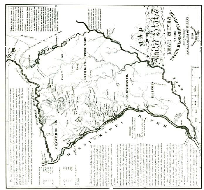
PREFACE

       The year 1988 marked a milestone in Arsenal Island history, for in that year, the Rock Island Arsenal
(RIA) celebrated designation of the arsenal's old stone buildings as National Historic Landmarks by United
States Secretary of the Interior. To commemorate such an occasion, the Rock Island Arsenal Commander,
Colonel David T. Morgan, Jr., has requested that this illustrated historic series be completed.

        An Illustrated History Of The Rock Island Arsenal And Arsenal Island Part One (Revised Edition)
covers nearly two hundred years of island history prior to the establishment of the Rock Island Arsenal. This
historical overview explains, through the use of photographs and words, the rich historic past of Arsenal
Island.

         The United States Government's presence on Rock Island makes it the oldest institution in the Quad-
Cities area. The government's historic ties with Arsenal Island date back to the signing of the Treaty of 1804
and the establishment of Fort Armstrong on the island in 1816. The United States flag flew above Rock Island
long before any of the communities of the surrounding area were founded. Even before Illinois and Iowa had
achieved statehood, the U.S. Army had established a significant military presence on Rock Island with the
building of Fort Armstrong. The fort served as a sanctuary to early pioneers who sought refuge behind its
walls during the threatening days of Indian uprisings. Part One also examines the historic ties and conflicts
between the government and local interests concerning the economic development of Rock Island. This
illustrated history is intended for the enjoyment and education of its readers.

        The author would like to thank Colonel David T. Morgan. Jr., for requesting such a project; Dr. Herbert
P. LePore, Chief of the AMCCOM Historical Office, to whom l owe a special thanks for guiding my work
through this revised edition, and taking time from his busy schedule to personally edit the text of this work.
Also, I would like to express my appreciation of the support of people and organizations both within and
outside of government service. Key individuals within the Rock Island Arsenal community, such as Mr. Ronald
E. Sikorski, Mr. Patrick J. Broderick, and past RIA Commander, Colonel John S. Cowings, sustained my
efforts during the completion of the first edition. Likewise, the Rock Island Arsenal Historical Society
supported the publication of the first edition. I would like to acknowledge the encouragement I received from
my colleagues, Dr. Robert H. Bouilly and Mr. Ralph C. Krippner. Thanks is also due Mrs. Allie Callear for
assisting in developing the format and putting the narrative of the first edition into the computer and to Mrs.
Carol Secoy and Ms. Nancy Newton, AMCCOM Historical Office, for respectively providing the necessary
editorial support and administrative support for the revised edition. In addition, thanks are extended to the
Field Printing Plant for their professional assistance.

                                           THOMAS J. SLATTERY
                                              October 1988

                                                      v
Below Left: Replica of Fort Armstrong
Blockhouse dedicated during the
Fort Armstrong Centennial Celebration
Held 18-26 June 1916.
Below Right: North of Old Stone Shops, on
Rodman Ave., built over a twenty-five
year period beginning in 1867.
(AMSAS-HI)

CHAPTER ONE
HISTORIC ROCK ISLAND
                                                                       The history of Rock Island is divided into
        The history presently being preserved at
                                                              three successive eras: the regional history and two
the Rock Island Arsenal encompasses more than
                                                              periods of "permanent" U.S. Government
the history of the arsenal itself. It also includes the
                                                              occupancy on the island. The regional history
frontier history of Fort Armstrong, the regional
                                                              includes those events prior to 1816 which led to
history of Colonel Davenport, the regional history
                                                              the government establishing a military post on the
of Black Hawk, the history of the first bridge to
                                                              island. The military post and the depot era of Fort
span the Mississippi River, and the Civil War
                                                              Armstrong constituted the first "permanent"
history of the Rock Island Prison Barracks. The
                                                              presence of the U.S. Government on Rock Island;
entire island is listed on the National Register of
                                                              The establishment of Rock Island Arsenal was the
Historic Places, and is known as Arsenal Island. In
                                                              second government presence. Rock Island has
June 1988, the Secretary of the Interior designated
                                                              made an indelible contribution to local and national
the old stone buildings, which formed the 19th
                                                              history.
Century Rock Island Arsenal, National Historic
Landmarks.

                                                          1
Below: Pere Marquette, a Jesuit Missionary, and Louis Joliet, trader and explorer, were the first Europeans to travel the upper
Mississippi River. They entered the river from Green Bay by way of the Fox River-Wisconsin River portage route in 1673. (“Pere
Marquette and the Indians” by Wilhelm Lamprecht public domain image)

CHAPTER TWO
ISLAND HISTORY PRIOR TO 1816

        In the days of the Old Northwest, where the                upper Mississippi River. However, it was not long
Mississippi River formed the western boundary of the               before French-Canadian voyageurs and coureur
United States, Rock Island was in the "backwaters" of              de bois from Prairie du Chien, began extending
American history. Throughout the 18th and early 19th               trading operations down river. These French-
centuries, history seldom had an impact on Rock                    Canadians established trade with various Indian
Island.                                                            tribes along the Mississippi River and its main
        On the occasions when it did, it was in                    tributaries.
support of historical developments which were                               Voyageurs      were      French-Canadians
taking place up river at such places as Prairie du                 employed by fur traders to transport "made goods"
Chien, Dubuque, and Galena. The prospect of                        and canoes from the remote regions of the Old
acquiring wealth initially attracted Europeans and                 Northwest. A coureur de bois differed from a
white Americans to the fur trading area of Prairie                 voyageur in that he operated without a French fur
du Chien and the lead region of Dubuque. French                    license, and he often illegally traded with the
traders seeking to expand their Indian trade                       British. Often the coureur de bois was a French-
discovered that the most convenient route, from                    Indian woodsman.
the Great Lakes to the Mississippi River, was by                            Early fur traders in the Rock Island area
the Fox River-Wisconsin waterway. At each end of                   paddled a canoe called the Canot du Nord or North
the route important French fur trading communities                 Canoe. The North Canoes were 20 feet in length
developed. Prairie du Chien, at the mouth of the                   and could carry as much as a ton of cargo besides
Wisconsin River on the Mississippi, and Green Bay                  its crew of eight voyageurs. The cargo primarily
on Lake Michigan anchored both ends of the Fox                     consisted of trade goods which were packed into
River-Wisconsin River portage route.                               90 pound bundles for easier handling. The bundles
        Prairie du Chien, not Rock Island,                         contained the material originally       needed for
was originally the leading fur trading post on the                 bartering such as cloth, kettles, traps,
                                                              2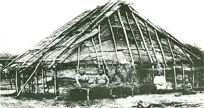
Right: The Fox River - Wisconsin River Portage Route was a
convenient fur trading route that linked the Great Lakes with
the Mississippi River. (Jo Davies County Historical
Society, Galena, Illinois)

blankets, guns, ammunition, and whiskey.
        Several French traders, and later British
agents, referred briefly in their journals to the "big
island" (Rock Island) at the bend of the Mississippi
River near the "upper rapids". These early journals
mentioned in greater detail the Sauk camp near the
mouth of the Rock River and also Credit Island, an
island which was situated a mile or so downstream
from Rock Island.
        French-Canadian traders seemed to prefer
Credit Island to Rock Island as the site of their
trading and established a small trading post on                             Foreign intrigues planned by British agents
Credit Island. These traders extended credit to                     successfully brought most of the Indian nations of
Indians in exchange for their promise of pelts. The                 the Old Northwest, including those of the upper
island, so associated with this practice, became                    Mississippi River Valley under the influence of the
known as Credit Island. Later, British traders often                British. During the American Revolutionary War,
set up their trading camp on Rock Island instead of                 almost every tribe of the Old Northwest fought as
Credit Island when trading in the vicinity.                         auxiliaries for the British.
        Occasionally, after trading, a French-                              In 1778, Sauk and Fox warriors were
Canadian coureur de bois, or a woodsman known                       among the Indians who gathered at Montreal to
as a hiverqant, would spend the winter at the Sauk                  receive British presents and medals.1 Later in 1780,
village on the Rock River. By living among the                      Sauk and Fox braves participated in an un-
Indians, the trader not only established good                       successful attack on the town of Pencour, which
relations with the Sauk, but he also protected his                  eventually became St Louis, Missouri. These
investment by serving as a reminder to the tribe of                 Indians had joined a British force of soldiers,
their debt. In 1763, France lost its colonial                       traders, and other Indians from Prairie du Chien in
possessions in North America to Great Britain as a                  attacking Pencour. Lieutenant Colonel John
result of the French and Indian War. However,                       Montgomery, under orders from Colonel George
many of the French-Canadian traders and                             Rogers Clark, led a combined force of American
voyageurs continued to work in the fur trade, first                 Rangers, as well as French, Spanish, and
for the British and then later for the Americans.                   American settlers from St. Louis in a retaliatory
        After the French and Indian War, the British                strike against the Sauk village located at the mouth
Government in Canada continued the French                           of the Rock River. Colonel Montgomery and his 300
practice of providing gifts to Indians. The tribes                  men supposedly burned the Sauk village, making
made pilgrimages each spring to the Canadian                        this action the westernmost conflict of the American
communities of Montreal and later Malden to                         Revolution.2
council with their “great father” where they would                          Later, under the provisions of the 1783
also receive presents. British medals and flags                     Treaty of Paris which ended the American
were presented to Indians who agreed to trade with                  Revolutionary War, the British ceded to the
British agents. Malden is situated near Windsor,                    United States a huge western tract of land
Canada.

                                                                3
Below: Voyageurs “Shooting the Rapids.” Early fur traders used similar canoes in the Rock Island area. (“Shooting the Rapids” by
Frances Anne Hopkins, public domain image)

                                                                      established the precedence of negotiating formal
known as the Northwest Territory. The territory                       treaties with the Indians to gain possession of land
included the present states of Illinois, Indiana,                     they occupied. These treaties defined and
Michigan, Ohio, Wisconsin, and part of Minnesota.                     redefined boundary lines between advancing white
         Britain, unwilling to give up its valuable                   settlements and retreating Indian Tribes. In many of
trade with Indians of the territory, continued to                     the treaties, provisions were added to establish
operate its trading companies on North American                       forts at strategic locations within the newly drawn
soil, from Canada. Long after the treaty was signed,                  boundaries of the Indian territory. This chain of
British agents continued to trade along the upper                     events formed a scenario which was repeated as
Mississippi River Valley, including the Rock Island                   the American frontier advanced through the
vicinity. British traders used their influence among                  Northwest territory.
the Indians to discredit their competitors, the
American traders. The British government in                           Lead Mining and Other Trade with the Indians
Canada, acting in its own interest, agreed to supply
arms and ammunition to Indian leaders such as                                 In the 18th and early 19th Centuries,
Tecumseh, who formed an Indian confederacy to                         European trade with the Sauk and Fox Indians
counter the encroachments of American traders                         involved more than fur pelts. Although pelts were
and settlers into the Northwest. The noted Sauk                       profitable, Europeans also traded for lead, corn,
warrior, Black Hawk, was among the braves that                        beeswax, feathers, and tallow.3 Lead was of
joined the confederacy. As American settlers                          particular importance to European and American
advanced through the frontier of the Northwest,                       traders. In fact, Sauk and Fox women were taught
they defeated the confederacy at Fallen Timbers,                      by Frenchmen to mine for lead and to operate
Ohio, in 1794 and at Tippecanoe Creek in 1811.                        crude furnaces near the Fox villages, which were
         In dealing with the Indians of the Northwest                 close to the present city of Dubuque, Iowa. The
Territory, the        United   States Government                      Sauk      of   the   Rock    River   region   and

                                                                 4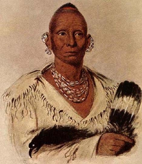
Below: The 1840s lead mining community of Galena, Illinois. Note the smoke from the lead furnaces operating in the hills. (Alfred W.
Mueller, Galena Historical Collection)

the Fox Indians of both the Rock Island and                                    By purchasing the Louisiana Territory from
Dubuque vicinities developed a brisk trade in lead                    France in 1803, the United States doubled its size,
with Europeans.                                                       and opened the mouth of the Mississippi River to
        The French initially attempted to develop                     American commerce. The Mississippi River no
the lead region of Northeast Iowa, Northern Illinois,                 longer formed the western boundary of the U.S.,
and Southern Wisconsin. However, a series of                          and by the early 1820s, speculators began leasing
Indian wars with the Fox Indian tribe severely                        land in the lead region of the upper Mississippi
hindered French mining efforts. Fox warriors                          Valley from the United States Government. Out of
periodically raided the fur and mining expeditions                    the mining area along the Fever River in Illinois
that traveled the portage route between Prairie du                    grew the mining community of Galena. Numbering
Chien and Green Bay. When not actually raiding                        less than 50 persons in 1822, Galena’s population
the expeditions, they extracted a tribute from those                  rose to over 10,000 people a decade later. The
that traveled the route. The Fox tribe, in order to                   sudden influx of miners resulted in clashes between
survive a war of annihilation waged on them by the                    the mining communities and Indians of the area.
French, allied themselves with the Sauk Tribe from                    This led to the “Winnebago War” of 1827. The
the Saginaw Bay area of Michigan. Eventually, the                     short-lived uprising led by Red Bird, a Winnebago
two tribes migrated to the mouth of the Rock River                    chief, was easily put down by a show of U.S. Army
near Rock Island.4                                                    Regulars.
        In 1788, the Fox Indians granted lead
diggings near the present city of Dubuque to Julien                   Federal Government Acquires Rock Island
Dubuque, a French trader. Miners such as
Dubuque shipped lead down river to St. Louis                                  In 1804, Rock Island came under Federal
instead of by portage to the Great Lakes.5                            control. President Thomas Jefferson instructed the

                                                                 5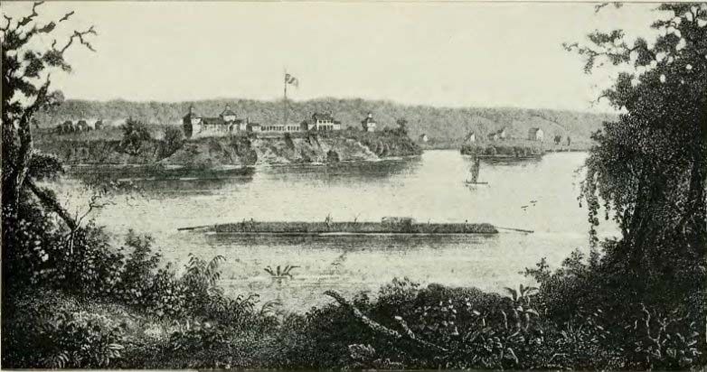
Below: Water’s Lead Furnace near Dubuque. Note the 75 lb. lead “pigs” stacked behind the scale. (from Benjamin F. Gue, “History
of Iowa from the Earliest Times to the Beginning of the Twentieth Century,” 1903, now public domain)

                                                                                In return, the Indians were to receive the
Governor of the Indiana Territory, William                             official protection and friendship of the United
Henry Harrison, to acquire Indian lands which                          States, and were to be paid $2,234.50 in goods,
adjoined the Mississippi River and its tributaries.                    plus an additional guaranteed annuity of $1,000 in
Harrison, later the ninth President of the United                      goods to be received annually thereafter.7
States, made an effort to obtain Indian land                                    A story regarding the unethical practices
cessions. Through bribery, liquor, and threats, he                     used by William Henry Harrison during negotiations
seized every opportunity to “negotiate” land away.6                    with the Sauk and Fox chiefs has been included in
Through negotiations Harrison succeeded.                               several historical works of the Rock Island area.8
        In November 1804, four Sauk and two Fox                        The minor chiefs supposedly told members of their
chiefs arrived in St. Louis to meet with Harrison                      tribes that they were inebriated during the majority
regarding the release of a Sauk brave being held                       of their stay in St. Louis. The chiefs explained that
for killing a white man. Harrison, during                              the $2,234.50 of trade goods they were to receive
negotiations for the release of this brave,                            from the Federal Government was instead given to
persuaded the chiefs to sign a treaty which ceded                      Pierre Chouteau, a wealthy French fur trader, for
to the U.S. a vast tract of land controlled by the                     payment of the chiefs’ expenses. Chouteau
respective tribes. The ceded land included territory                   witnessed the signing of the treaty and also served
on both sides of the Mississippi River, roughly                        as host for William Henry Harrison during his visit to
between the Wisconsin River to the north and the                       St. Louis. As for the brave being held by army
Missouri River to the south; and extending east to                     authorities, he allegedly was shot while running
the middle of the present Illinois River and west as                   from his guards.9
far as the watershed region between Des Moines                                  Later, a dispute over the meaning of Article
and the Missouri River. Both the Sauk villages on                      Seven of the 1804 Treaty was of great concern to
the Rock River and in Rock Island were included in                     the Sauk and Fox Indians in Illinois. Article Seven
the land purchase.                                                     stated:

                                                                  6
Below: An 1829 map of the U.S. lead mines in the upper Mississippi River region. At that time, the mines were worked by private
individuals who paid the U.S. Government a tenth of all the lead manufactured for the privilege. Much of the lead was shipped down the
Mississippi River through the Upper Rapids at Rock Island, on its way to St. Louis, Fort Armstrong, Rock Island, and the Upper Rapids
appear at the lower left corner of the map. (Wisconsin State Historical Society)

                                                                  7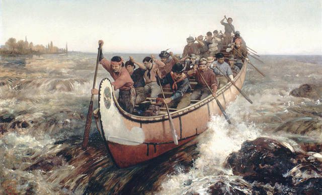
Below: The Old Chouteau Mansion in St. Louis, MO.
Right: Brothers Pierre and Auguste Chouteau, early
French fur traders who respectively participated
in the 1804 and 1816 U.S. treaty negotiations
with Sauk and Fox Indians. (Both photos from
Augustana College Library Special Collections)

         As long as the lands which are now                 counseling them. They also readily extended them
         ceded to the United States remain                  credit for pelts yet to be trapped. The British
         their property, the Indians belonging              especially ingratiated themselves with the Sauk
         to said tribes (Sauk and Fox) shall                Indians through the use of these tactics. The gifts
         enjoy the privilege of living and                  and credit placed them in good favor with the Sauk,
         hunting upon them.10                               while at the same time indebting the Indians to the
                                                            British for some future request or deed.
        The six chiefs who agreed to the 1804                        In contrast, the U.S. Government would not
Treaty were supplied with liquor, but not                   allow its agents to extend credit to Indians. United
unknowingly. Liquor was certainly nothing new to            States agents were instructed to receive pelts, land,
the chiefs for Sauk and Fox Indians had been                or something tangible in exchange for their trade
trading with French and British agents for over a           goods. For several years after the treaty, many
century and a half. Many traders included liquor as         Sauk believed that the $1,000 annuities they
part of the trade goods offered to the Indians of the       received from U.S. agents were “presents” rather
upper Mississippi River Valley.                             than payments for their land.11 As experienced as
        The chiefs probably believed they were              the Sauk and Fox were in dealing with Europeans,
receiving free liquor in exchange for granting              they nevertheless struck a “bad bargain” with
Americans the use of hunting grounds they already           William Henry Harrison.
shared with other tribes. Furthermore, the White
Americans concept of land as property was foreign           Rock Island Comes to the Attention of the U.S.
to Indians. Adding to their confusion were the              Army
differences they encountered negotiating with
American      agents   rather    than    Europeans.                 Lieutenant Zebulon Pike first brought Rock
Europeans gave “presents” to the Indians after              Island to the attention of the U.S. Army. In 1805,

                                                        8
Right: William Henry Harrison, the first Governor of the
Indiana Territory which included Illinois, was appointed
special commissioner to negotiate boundary treaties with
various Indian tribes. Later, William Henry Harrison
became the ninth President of the United States (AMSAS-HI)
Below: Excerpt from beginning paragraph of the 1804
Treaty with Sauk and Fox Indians cited below. Note
that the purpose of the article was to bring the two
tribes under U.S. influence by restricting the tribes’
dealings with foreign powers. (AMSAS-HI)
A Treaty Between the United States of America
and The United States of Sac and Fox Indians
Articles of a Treaty made at St. Louis in the
District of Louisiana Between William Henry
Harrison, Government of the Indiana Territory
and District and Commissioner Plenepotentary of
the United States for concluding any treaty or
treaties which may be found necessary with any
of the Northwestern Tribes of Indians of the
one part, and the chiefs and headmen of the
United Sac and Fox Tribes of the other part.
Article 1. The United States receive
the United Sac and Fox Tribes into their
friendship and protection, and the said
tribes agree to consider themselves under the
protection of the United States, and of no
other power whatsoever.
Right: Early U.S. Army posts near
St. Louis, MO, such as Fort Bellefontaine,
Camp Adams, Cantonment Miller, and Jefferson
Barracks, served as the starting points for
numerous military expeditions and exploratory
ventures into the Upper Mississippi River Valley.
Jefferson Barracks is depicted in early sketch
to the right. (Augustana College Library Special
Collections)
he led an expedition up the Mississippi River from
St. Louis. His instructions were to gather Based on Pike’s report, Congress passed
information regarding the river and to note potential legislation in June 1809 to reserve Rock Island, or
sites for the construction of forts which were to be “big island” as it was referred to in Pike’s journal, as
strategically located in the new territory. In addition, a federal military reservation.
Pike was to record British activity among the Pike recorded several chance meetings with
Indians of the upper Mississippi River Valley. individuals and groups on his journey up the
9Below Left: Lieutenant Zebulon Pike, who in 1805 led an exploring party up the Mississippi River, is pictured at the left. (Hauberg
Museum, Black Hawk State Park)
Below Right: Winter lodge of Sauk and Fox Indians. (Hauberg Museum, Black Hawk State Park)
Mississippi River. In the vicinity of Rock Island, he expressed hostility towards Americans during his
met with James Aird, a fur trader from Prairie du visit to their village near Rock Island. Pike also
Chien who operated a trading camp on Credit wrote that a White American, working as a
Island. Mr. Aird informed Pike that in 1781 or 1782 government representative, was living among the
the Sauk village on the Rock River was burned Sauk and Fox Indians of the Rock Island vicinity.
down by about 300 Americans. This account The American was hired to teach the Indians
corroborated the story regarding Colonel methods of farming; but, according to Pike, was
Montgomery’s raid on the Sauk village during the fired the following year for neglecting his job. The
American Revolution. According to his journal, Pike teacher’s position was a provision of the 1804
met with four canoes of Sauk warriors near Rock Treaty with the Indians.
Island.
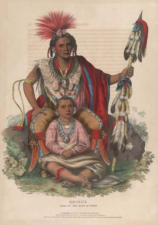
Sauk and Fox Indians
We met four canoes of the Sacs,
with wicker baskets filled with young Lieutenant Pike’s journal supported the
pigeons. They made motions to claim that Sauk and Fox warriors had a reputation
exchange them for liquor to which I for being hostile. When Fox and Sauk warriors
merely turned the back of my controlled the Fox River- Wisconsin River portage,
hand.12 they were notorious for demanding tribute from
those who traveled the route. They were also fond
Another encounter with Sauk warriors was of “taking” pelts from neighboring tribes. French
also included in the Pike journal. Pike mentioned in traders at Green Bay, tired of the hostile ways of
his journal a meeting he had with a Captain Many, the two tribes, formed an alliance with the
who was traveling the river in search of Osage Menominee, the Ottawas, and the Chippewas and
Indian prisoners among the Sauk and Fox Indians forced the Sauk and Fox from the area.
of the region. Captain Many told Pike that the Sauk
10Below: Traditional Sauk and Fox summer lodge covered with tree bark. (Quad Cities Times Newspaper, Photo Archives.)
American artist George Catlin referred to a
While migrating to the Rock River in present day Sauk village on the north banks of the Rock River
Illinois, the Sauk and Fox warriors drove the Illini as “Saug-e-nug” in his 1837 writings. This may
Indians from the Rock Island and Rock River explain the popular use of the term “Saukenuk” for
regions out. the name of the village since the Sauk and Fox had
In addition to defeating the Illini and nearly no written language and traders simply wrote down
annihilating the entire Mascoutin tribe, the Sauk what they heard. Although neither tribe located its
and Fox Indians also sent war parties out against village on Rock Island, they frequently visited the
the Menominees, the Sioux, the Pawnee, and the island to gather berries, nuts, fish, and hunt game.
Osage, among others. Today, writers and local
museum curators tend to emphasize the Sauk’s Black Hawk’s British Band and the War of 1812
planting, mining, and hunting skills rather than their
fighting ability. However, the Sauk and Fox were Sauk and Fox chiefs attempted to honor the
proud of their reputation as fierce warriors. 1804 agreement with the U.S. Government.
11Below: Sauk warrior Black Hawk as painted by American artist George Catlin. The original painting by George Catlin is in the
National Portrait Gallery, Smithsonian Institution, Washington, D.C. (AMSAS-HI Archives)
However, when war broke out between the United Green Bay, and for a time fought as an ally of the
States and Britain in 1812, a large band of Indians British during the War of 1812. Despite his desire to
led by the Sauk warrior Black Hawk chose to fight wage war down the Mississippi Valley, the British
as auxiliaries for the British. Black Hawk, also instructed Black Hawk to fight with their troops near
called Ma-Ka-Tai-Me-She-Kia-Kiak or “Black Detroit. Black Hawk and his Sauk warriors were
Sparrow Hawk” allegedly offered his services to present during the Fort Dearborn Massacre of 15
American soldiers at Fort Madison; but the soldiers August 1812. However, after initial success, the
declined the offer. It was known that Black Hawk fighting did not go well for the British, and Black
was displeased with the Americans at Fort Madison Hawk returned to his village on the Rock River.
for refusing to extend him credit for winter supply Though he returned to the village, Black
goods. Therefore, when the British traders arrived Hawk remained hostile towards the United States.
at Rock island, he readily welcomed them. These On three occasions during the War of 1812, Black
traders had a variety of gifts for the Indians and a Hawk led Sauk warriors against U.S. military forces
confidential message for Black Hawk. The attempting to journey up river from St. Louis.
message, from a British colonel, urged Black Hawk Governor William Clark of the Missouri
to raise a war party and join the British force at Territory, and famous partner of the explorer
Green Bay. Meriwether Lewis, organized the first expedition
The British Colonel was Robert Dickson, a from St. Louis in 1814. Clark intended to build a fort
trader active in recruiting Indians to aid the British near Prairie du Chien to protect American fur
in the War of 1812. He had long been a trader at traders in the upper Mississippi River Valley, and to
Prairie du Chien. create a buffer protecting St. Louis from British and
Black Hawk raised the war party, traveled to Indian attack via the Mississippi River.
12Below Left: William Clark, Governor and Superintendent of Indian Affairs for the Missouri Territory. He supervised the U.S. Indian
agents at Fort Armstrong. (Hauberg Museum, Black Hawk State Park)
Below Right: The 1905 dedication of the Illinois State Memorial commemorating the 1814 Battle of Campbell’s Island. (Rock Island
County Historical Society)
With the exception of a skirmish with Sauk trailing the three boats and ambushed the stranded
Indians near Rock Island, Clark’s expedition craft. Lieutenant Campbell and several members of
uneventfully made its way up river to Prairie du his crew escaped to another vessel. The National
Chien. At Prairie du Chien, Clark’s men erected a Intelligencier of August 1814 stated the number of
stockade and named it Fort Shelby. The killed and wounded in this engagement to have
detachment of American troops left behind at Fort been thirty-six. Lieutenant Campbell and surgeon’s
Shelby was attacked by the British, forcing them to mate Dr. Abraham Stewart were among the
abandon Fort Shelby and return to St. Louis. As wounded.13 Black Hawk pillaged the abandoned
they returned to St. Louis, the troops were again keelboat, while Sauk braves scalped the mortally
fired on by Sauk warriors as they passed Rock wounded and the dead left behind. Later, according
Island. to Black Hawk’s own account of this incident, the
An earlier attempt by American soldiers to Sauk warriors “put on the clothes of the dead
strengthen the garrison at Fort Shelby also failed. soldiers and danced over their scalps”. Black
Lieutenant John Campbell, with three keelboats Hawk’s account of this incident is recorded by
loaded with 133 regular army and volunteer Antoine LeClaire, a government interpreter and
soldiers, embarked from St. Louis in early July prominent businessman of the Rock Island area.
1814 for Prairie du Chien. On 19 July, Campbell’s According to LeClaire, Black Hawk stated that he
expedition departed Rock Island and immediately gave the books and papers found on Campbell’s
encountered bad weather. Forced ashore on an boat to British Soldiers.
island six miles upstream from Rock Island, Lieutenant Campbell’s boat, partially
Campbell’s vessel came under attack by Indians. destroyed by fire, remained at the battle site and
Black Hawk and other Sauk warriors had been
13Right: Colonel Zachary Taylor
who in the War of 1812 unsuccessfully
led U.S. forces against Sauk and Fox
Indians at the Battle of Credit Island.
Nearly twenty years later, Colonel
Taylor would lead U.S. Infantry
Regulars to victory over Sauk and Fox
Indians in the Black Hawk War of 1832.
Eventually, Zachary Taylor would
become the twelfth President of the
United States.
(AMSAS-HI Archives)
for years was a landmark for river boats. Since this Sergeant John Keating of the Royal Artillery
historic battle, the island has been referred to as Regiment earned a commission as a lieutenant for
Campbell’s Island. The Illinois state legislature, his efforts in the Battles of Credit Island and Fort
around 1904, appropriated $5,000 for a monument McKay. Besides providing artillery, the British had
to be placed on Campbell’s Island in gathered a large war party with Indians from other
commemoration of those who fought and died in pro-British tribes to aid the Sauk and Fox in their
battle. fight against the Americans. Greatly outnumbered,
there was little more Zachary Taylor could do but
Zachary Taylor and the Battle of Credit Island retreat.14
During the War of 1812, Zachary Taylor, British Control of the Upper Mississippi River
later the twelfth President of the United States, led Valley
a reprisal attack against the Sauk of the Rock River
region. In September 1814, as a Brevet Major, The rivalry between Great Britain and the
Taylor left St. Louis with 334 men, primarily militia United States for dominance over the Indians of the
and ranger, but also including a few regular army Northwest was a contributing factor to the War of
soldiers. His mission was to undertake a retaliatory 1812. The British in Canada, acting in their own
strike against the Sauk to punish them for their self-interest without regard to the safety of
attacks on the earlier American expeditions of Americans, began supplying arms and ammunition
Governor Clark and Lieutenant Campbell. to Indians known to be hostile toward Americans.
However, before he could attack, his vessels were Congress considered British support of the Indians
discovered. British artillery placed on Credit Island as one of the reasons for declaring war against
and Sauk musket fire riddled Major Taylor’s Great Britain.
vessels, forcing them to retreat back to St. Louis. During the War of 1812, Great Britain
Lieutenant Duncan Graham was the officer-in- temporarily gained control of the upper
charge of the British troops who aided the Indians.
14Right: Sauk warrior Black Hawk was the leader of
the last hostile Indian uprising in the State of
Illinois, known as the Black Hawk War of 1832.
Black Hawk stated that Rock Island supplied his
tribe with fruits, nuts, and plenty of fish
from the rapids. He said he spent happy
times on the island and that a good spirit
lived in a cave in the rocky bluffs beneath
the fort. “But the noise of the fort has
since driven him away and no doubt a bad
spirit has taken his place.”
Black Hawk’s Autobiography
(AMSAS-HI Archives)
Mississippi River Valley and the Great Lakes region that, as soon as possible, the government should
of the Illinois Territory. American authority in the exchange all British flags and medals the Indians
territory north of Fort Edwards collapsed. (The had in their possession for American ones. He also
location of Fort Edwards is cited on the map on wrote that the flags given to them ought to be made
page 18). The war ended with the British in control of silk which would make them as durable and
of all the U.S. forts and the U.S. Government portable as the British flags. According to Major
trading factories in the Illinois Territory above a line Marston, these American flags should be large to
that stretched from Fort Edwards to Peoria. match the size of the British flags.16
Pro-British sentiment remained strong
among some of the Indians of the Northwest after Treaty of Portages des Sioux
the war. Indians such as the Sauk and Fox
continued to trade with the British after the War of Though Black Hawk’s warriors had been
1812 and, as late as 1820, Sauk warriors such as successful in thwarting American expeditions up
Black Hawk continued to make their annual river from St. Louis, the war was not totally
pilgrimage to Fort Malden, Canada, to receive successful for the British. On 24 December 1814,
presents during their visit with their “British Father.” the War of 1812 concluded with the signing of the
Five years after the end of the War of 1812, some Treaty of Ghent. Though peace with the British was
Indians, such as the Sauk of Rock River, continued achieved, such was not the case with their Indian
to display the British flag and British medals in their mercenaries or allies.
village. The British in Canada had cast a special However, in 1815, President James
silver medal to honor Black Hawk for efforts during Madison appointed Missouri Territorial Governor
the war.15 William Clark, Illinois Territorial Governor Ninian
Major Morrell Marston, while commanding Edwards, and Auguste Chouteau, a St. Louis fur
officer of Fort Armstrong, wrote to Jedediah Morse trader, as commissioners to negotiate treaties
in November 1820 that he considered it important
15Below Left: Often government trading factories were established at military posts. Fort Howard at Green Bay was one such post.
(AMSAS-HI)
Below Right: A typical fur trader of the Northwest Territory. (Augustana College Library Special Collections)
with the principal tribes who aided the British during trading factories and trading posts in the Northwest.
the War of 1812. Nine months later, in September These government owned and operated trading
1815, the U.S. signed a separate peace treaty at houses made the Indians more economically
Portages des Sioux with all but a few of the Indians dependent upon the United States, and by doing
who had fought for the British. Instead of attending so, diminished the influence of foreign traders upon
the peace conference, the Sauk of the Rock River them. The government intended the trading
sent messengers to Canada to meet with the factories to also provide the Indians with a more
British. However, the messengers returned without equitable deal than they had been receiving from
a promise of aid from the British. Receiving no private traders, especially the unscrupulous ones.
support and fearing an attack by American troops, Unfortunately, the government trading
the Sauk of the Rock River agreed to peace terms factories were ineffective and too costly to maintain.
in St. Louis on 13 May 1816. The treaty, approved They had higher overhead prices than the private
by Sauk leaders, including Black Hawk, reaffirmed traders, which may account for the fact that the
the United States Government’s claim to Sauk and government prices were usually higher than those
Fox Indian lands according to the terms set down in of the private trader. The Indians continued,
the Treaty of 1804. however, to trade with foreign agents and private
American traders, though ostensibly under
Government Trading Factories government control.17
A note written by Major Morrell Marston, of
As early as 1795, 17 years before the War the Commanding Office at Fort Armstrong on Rock
of 1812, the U.S. Government devised a plan to Island from August 1819 – June 1821, best
reduce the presence of private traders upon the expressed the Indian attitude toward attempts by
Indians of the Mississippi River Valley. The Federal the U.S. Government to compete with private
Government established a system of government
16Right: Private traders regularly
traveled to the Indian villages with
their trade goods, contrary to the
practice of government traders, who
operated trading posts known as factories.
(Augustana College Library Special
Collections)
traders for their Indian trade. According to Major upper Mississippi Valley purportedly traded
Marston, a typical reply by Indians in his vicinity, anything they possessed for whiskey. Those
when informed that the President of the United Indians supposedly bartered away an entire
States supplied the trade goods at the government season’s worth of pelts, clothing off their backs,
trading houses, was: their weapons used for hunting, and their women,
to trade for liquor.19
You are pasi-i-to (a fool), our Great At the factories or trading posts, furs were
Father is certainly no trader; he has sorted as to grade and quality, and treated and
sent those goods to be given to use, pressed into bales in preparation for shipment.
as presents, but his agents are Trading houses, such as the Fort Edwards factory,
endeavoring to cheat us, by selling shipped pelts and skins of deer, bear, beaver, otter,
them for our peltries.18 raccoon, and muskrat down river to St. Louis.
During the winter season of 1819, the Sauk and
After the War of 1812, the U.S. Government Fox Indians supplied five traders 980 packs of
re-established trading factories at Prairie du Chien, peltries. The estimated value of the furs was cited
Chicago, and Green Bay. In 1818, for example, the at $58,000 dollars.20 A manager supervised each
government added a trading house at Fort Edwards factory and, at times had a staff that included
and, in 1819, it was operating independently. The clerks, laborers and interpreters.
high traffic of liquor traded to Sauk and Fox Indians Government trading factories were too few
between the region of Fort Edwards and Rock and scattered to have had any effective impact on
Island led to the establishment of the federal the fur trading business of the Northwest. The
trading factory at Fort Edwards. The trading of government estimated that during their peak years
liquor to Indians, though illegal, was commonly the factories only handled ten percent of the fur
practiced by French, Spanish, English, and business. Indians saw little advantage in
American Traders. As an aside, Indians of the
17Right: Fort Armstrong, Fort Edwards,
Fort Crawford, and Fort Snelling
formed a chain of military posts, built
along the upper Mississippi River, in
1816-1819. The U.S. Army constructed
them to control the Indians and their
trade, and to keep the river open to
commerce.
(AMSAS-HI)
trading at the factories. It was more convenient for
them to deal with private traders who traveled to in the Great Lakes region of the United States, and
their villages than to transport their pelts on a long secured the services of the best traders in the
journey to one of the scattered government trading upper Mississippi River Valley and Great Lakes
houses. In addition, the government trading region in his effort to corner the fur trade. The
factories did not extend credit or offer liquor. beginning of the American Fur Company’s
Government trading factories eventually lost out to operation in the Northwest in 1817 coincided with
the powerful American Fur Company of John Jacob the army’s establishment of a series of military
Astor and were abolished in 1822. posts through the region. Two agents of the
American Fur Company in the Rock Island vicinity
Act of 1816 and the American Fur Company were Colonel George Davenport and Russell
Farnham, both of whom played significant roles in
Congress passed the Act of 1816 that Rock Island’s history.
prohibited foreigners from engaging in trade with
the Indians on American soil. John Jacob Astor, the Army Establishes U.S. Authority in Valley
leading American fur trading entrepreneur, lobbied
for the passage of the bill. After securing the The War Department, acting in support of
legislation, Astor immediately expanded the the Fur Trading Act of 1816, began that same year
American Fur Company and set into motion his to reassert its authority over the Northwest. The
place to control the entire fur trading business U.S. Army planned to construct a chain of military
within the United States. He purchased the posts through the upper Mississippi River Valley
remaining third of the Southwest Company which and the Great Lakes region. The purpose of
he had earlier formed with Montreal merchants, constructing these posts was twofold: the forts
thus making him the sole owner. Astor then provided safety for American fur traders and
acquired a number of trading posts of the British prevented British and French-Canadian traders
Northwest Company, which were on American soil from opening in the area.
18Below: Fort Snelling built in 1819, was originally named Fort Saint Anthony Falls. In 1824, it was renamed for its first commander
Josiah Snelling. The Fort was situated on a high bluff at the confluence of the Minnesota and Mississippi Rivers. The construction of
Fort Snelling completed a series of U.S. forts built to re-establish United States control of the upper Mississippi River Valley. Today, it is
a historical site of the Minnesota State Historical Society. Fort Armstrong, at Rock Island, was another of these posts built after the War
of 1812. (AMSAS-HI)
Government at many of the forts of the upper
During the period from 1816 to 1819, the Mississippi River Valley. Agents, such as Thomas
United States Army reconstructed Fort Dearborn Forsyth at Fort Armstrong, provided a
near Chicago, built Fort Howard at Green Bay, and communication link between the Sauk and Fox
constructed Fort Crawford at Prairie du Chien. Indians and the Federal Government. The duties of
These forts effectively prevented foreign traders Forsyth and his subagents included administration
from using the Fox River-Wisconsin Waterway of the Government’s treaty obligations such as the
portage to enter the Mississippi River Valley. In payment of annuities to the Sauk and Fox tribes.
addition to Fort Crawford, two smaller posts were Forsyth’s other duties included granting licenses for
constructed in 1816-1817. They were Fort trade with the Indians; enforcing regulations
Armstrong at Rock Island and Fort Edwards at the pertaining to the fur trade; distributing presents to
mouth of the Des Moines River. In 1819, Fort principal chiefs; and receiving visiting Indians.
Snelling, constructed at the confluence of the Indian agents also performed the difficult task of
Minnesota and Mississippi Rivers, completed the explaining new government regulations and
series of forts along the upper Mississippi River correcting Indian misconceptions of past treaties.
Valley.21 The army strategically placed the forts An example of an Indian agent performing
where it did to impress the Indians and monitor such duties occurred in 1818, when agent Thomas
their trade. Government Indian agencies were also Forsyth informed the Sauk and Fox tribes that the
frequently established at or near these military annuities they had been receiving were not
posts. presents but actually part of the purchase price for
their lands. Although many Indians continued to
Indian Agents accept the annuities, some did not. Black Hawk
among others, refused to receive any annuities
Indian Agents and their subordinates were after hearing Forsyth.22
the official civilian representatives of the U.S.
19Below: Fort Armstrong, active 1816-1836, situated on the northwest corner of Rock Island, strategically placed to control both
channels of the Mississippi River. (AMSAS-HI Archives)
CHAPTER THREE
FORT ARMSTRONG: THE FIRST PRESENCE OF FEDERAL GOVERNMENT ON ROCK ISLAND
In the spring of 1816, Brevet Brigadier On 10 May 1816, a detachment of troops
General Thomas A. Smith was dispatched from St. from the U.S. 8th Infantry landed on the island and
Louis to Rock Island. As earlier mentioned the War immediately began building a fort. Shortly
Department instructed the army to build a number thereafter, General Smith and a detachment of
of military posts on the upper Mississippi River to troops proceeded up river to construct Fort
deter British and other foreign trading outfits from Crawford at Prairie du Chien. In General Smith’s
operating in the river valley. General Smith, absence, Colonel William Lawrence assumed
remembering the defeats inflicted upon U.S. command of the construction site at Rock Island
expeditions by Sauk and Fox Indians, selected and, upon completion, the fort at Rock Island was
Rock Island as a site for one of the forts.23 named Fort Armstrong in honor of John Armstrong.
Brigadier General Smith arrived at Rock John Armstrong had been an army officer in
Island in early May 1816 and chose the western tip the American Revolutionary War and later served
of the lower end of the island as the construction as Secretary of War under President James
site for the fort. From this site U.S. troops could Madison. His role in the U.S. invasion of Canada
observe the troublesome Sauk and Fox Indians; during the War of 1812, coupled with the British
protect American fur traders; and keep open a line retaliatory capture of Washington and the burning
of communication and commerce to Prairie du of the capital, led ironically to Armstrong’s
Chien and other posts further up river. resignation as Secretary of War in 1814.
20Below: View of Fort Armstrong. Note the absence of fortified walls on the sides facing the river. The 25’ to 30’ high bluffs provided
sufficient protection. Also noticeable are the caves beneath the bluff that Black Hawk referred to in his autobiography. (AMSAS-HI
Archives)
Description of Fort Armstrong
In many respects Fort Armstrong The Fort (Armstrong) is situated
represented the army’s stock plan for building immediately upon the lower
military posts on the Western Frontier. It had extremity of Rock Island, at which
squared hewn timbers with dovetailed corners; and place the shores are perpendicular
its blockhouses had an overhang and a monitored cliffs of limestone 30 feet high. In
roof which provided a lookout station. Usually, some instances the cliffs project
building such as the barracks, which were made over their base and even some parts
from hewn timber, formed the exterior walls of the of the Fort overhang the water.
fort. The most noticeable feature of the barracks
were their inward-sloping shed-type roofs. Major Long elaborated with the following
At many of the frontier military posts pickets detailed description of Fort Armstrong:
were stationed to guard against surprise attacks. In
1817, the army assigned Major Stephen H. Long, a The Fort (Armstrong) has two entire
topographical engineer, the task of charting the faces only, the other two sides being
Mississippi River as far north as Prairie du Chien. sufficiently fortified against an
On 2 August 1817, Major Long wrote in his journal assault by the cliffs before
probably the best description of Fort Armstrong. He mentioned. The east face
wrote:
21Below: Fort Armstrong, about 1845, probably during its last days as an army depot. Note that the fort had three
blockhouses with the one towards the interior being the largest. (AMSAS-HI Archives)
commences immediately upon the parts of the works are situated 2
top of the cliff, where here is a Block buildings (one word illegible) 64 feet
(No.1) 2 stories high and 21 feet long & 16 wide, containing four
square. The front upon this side is rooms each, designed for officers’
277 feet including a Block House quarters. In the SW corner is a 2-
(No.2) at the NE corner of the Fort story building with low wings
26 feet square. The North face forms designed as quarters for the
a tight angle with the east and Commanding Officer and Offices for
extends from Block House No. 2 to the use of the Garrison. The body of
the North Channel of the River, the building is furnished with Piazzas
where it is terminated by Block on both sides, and the whole
House No. 3 of the same combines a degree of taste and
dimensions as No. 1, presenting a elegance worthy of imitation at all
front of this side of 288 feet. Both other military posts in this part of the
faces are flanked by Block House country.
No. 2, the other Block Houses being The works are constructed
placed in such a manner as to form principally of square timber, the
a part of the Front of the two faces. lower part of the block houses
The Block Houses are all two stories including embrasures (an opening
high, their second stories being for a gun in the war or parapet) is of
placed diagonally upon the first. No. stone. The Magazine also is of
2 has also a basement story which is stone, 7 by 10 feet in the clear, its
used as a store house. The faces walls 4 feet in thickness. Besides
are made up principally by the rear these, there are a few other
walls of the Barracks and store buildings outside the Garrison, viz. a
houses. They are about 20 feet high smith shop, sutler’s and contractor’s
and furnished with two rows of loop stores, a stable, etc.24
holes for muskets. The spaces
between the buildings are fortified by Fort Armstrong’s strategic position on the
walls of stone about 8 feet high western tip of Rock Island’s lower end provided the
supporting a breast work of timer 5 fort with command of both channels of the
feet high. Mississippi River. Troops constructed fortifications
The buildings ranged along only on the two sides of the post facing inland.
the Faces contain 7 rooms 20 feet Steep bluffs eliminated the need for two fort walls
square upon each side; 8 of which and one blockhouse. The three blockhouses of the
are occupied as soldiers’ quarters, 3 fort anchored the walls which faced the interior of
as hospitals, 2 as store houses, and the island, and three companies of infantry were
1 as Guard House. On the south and quartered in the barracks. Additional buildings
west sides detached from other housed the fort’s surgeon, interpreter,
22Below: Excerpted from a report by Major Morrell M. Martson, Fort Armstrong Commander, 1819-1821, to Major General Macomb,
dated 10 September 1819. Note that Major Marston’s report refers to the three blockhouses being equipped with three 6-pounders
(cannons). (AMSAS-HI)
Indian agent, blacksmith, servants, officer, and the Wisconsin River, had a garrison strength of
commander. approximately double the size of Fort Armstrong.
Fort Edwards, the first of the three posts to be
The Garrison at Fort Armstrong constructed, was situated near the mouth of the
Des Moines River at the site of present day
Nearly 1,000 men comprised General Warsaw, Illinois, and generally had a smaller
Smith’s expedition, which constructed military posts garrison than Fort Armstrong. It’s garrison strength
near the mouths of three major tributaries to the consistently numbered below 100 men. In 1824, the
Mississippi River. The expeditions were composed U.S. Army closed Fort Edwards. However, Fort
of 800 regular army soldiers and 150 laborers, Armstrong continued as an active military post until
which actually comprised at that time approximately 1836 and an army garrison remained at Fort
1/10 of the nation’s standing army.25 Crawford until 1856.
During construction, Fort Armstrong had a The initial site selection of Fort Crawford,
garrison of 600 soldiers; but, shortly thereafter that near Prairie du Chien, was poor. Spring floods
numbers were reduced to less than 200 troopers. forced the selection of a new site further back from
Frequently, between 1824 and 1836, the garrison the Mississippi. Fort Crawford was abandoned
at Fort Armstrong fell below 100 soldiers. briefly in 1826, but re-established a short time later
Fort Crawford, located near the mouth of with the construction of a new stone fort.
23Below: Fort Crawford, near Prairie du Chien, Wisconsin, at the confluence of the Wisconsin River and the Mississippi River. Spring
floods forced the selection of a new site farther back from the river. The post was abandoned briefly in 1826, but with the increasingly
hostile Indian situation a new stone fort was constructed. (Davenport Public Library Special Collections)
The small army posts situated in the West, Croghan attributed the lack of discipline to the lack
along the upper Mississippi River, were isolated of whiskey available at Fort Armstrong during Major
from civilization especially during the winter months J.H. Vose’s command. Major Vose enforced
when the river froze over. Periodic stops by supply general orders which restricted each soldier’s
boats or mail couriers who arrived by river or by purchase of liquor to one gill (1/4 of a pint or four
overland routes broke the isolation with news from ounces). The four ounce daily ration from the post
the East. Each post, however, was also visited by sutler was poured out at the mess hall door.
an inspector general who attempted annually to Soldiers who received permission to purchase
conduct an inspection tour of all posts on the whiskey received a half-a-gill ration (two ounces)
western frontier. His visits brought military discipline just before breakfast, and the remaining two
to the posts and raised the spirit de corps of troops ounces at dinner. Although general orders from the
whose spirit and training had eroded due to Adjutant General’s Office restricted, then banned,
isolation and the lack of soldierly instruction. the daily ration of alcohol at military posts, replacing
From 1826 to 1845, Colonel George it with coffee, the soldiers at Fort Armstrong and
Croghan, a hero of the War of 1812, served as the other installations managed to purchase a steady
inspector general of these outposts. Colonel supply of liquor from other sources.26
Croghan annually toured the Western Frontier, The life of a soldier at Fort Armstrong
inspecting posts and preparing first hand comments tended to be routine, especially during the winter
of activities at the forts for inclusion in his official months when the Mississippi River froze over and
reports to Washington. the river closed to navigation.
His inspection report of Fort Armstrong in The soldiers, in addition to their military
August 1826 praised the post for the excellent tasks of performing guard duty, drilling, and
deportment displayed by its soldiers. Colonel keeping the peace, served as carpenters,
24Below: A partial listing of the Commanding Officers of Fort Armstrong, 1819-1832. These Officers commanded the fort during the
events which led to the Black Hawk War of 1832. (AMSAS-HI Archives)
teamsters, gardeners, orderlies, blacksmiths, and soldier, John Haines, left Fort Armstrong alone to
livestock handlers. At times, a portion of the troops hunt on 27 September 1820. His body was
stationed at Fort Armstrong would be detached to discovered a week later, shot, scalped, and
either Fort Crawford or Fort Edwards. Soldiers also mutilated with multiple stab and club wounds. The
were frequently dispatched to the lead mining army responded to such acts of violence by
region near Galena and Dubuque. Officers demanding that the responsible tribe, in this case
stationed at Fort Armstrong, or at one of the other the Winnebagoes at Prophet’s Town, turn over to
frontier posts in the Mississippi Valley, often went them the guilty party. To ensure such actions were
on furlough to escape the drudgery of frontier duty. taken, the army held five Winnebago chiefs as
Soldiers on furlough for more than a year without hostages until the murderers were delivered to
leave, however, were reported as deserting the them.
army. Desertion and drunkenness among the
troops were two of the more serious problems that Colonel George Davenport and Antoine
the Commanding Officer of Fort Armstrong had to LeClaire
contend with on the frontier. Other problems
included enforcement of regulations that prohibited Two future entrepreneurs, George
foreign traders and the sale of alcohol to Indians. Davenport and Antoine LeClaire, became
Periodically, soldiers who strayed from the garrison historically significant individuals. Davenport was
were killed and scalped by Indians. One such employed as the post sutler at Rock Island and
25You can also read