Analysis of Needs Open Space Plan 2015-2021 - HARBOR OPEN SPACE - Boston.gov
←
→
Page content transcription
If your browser does not render page correctly, please read the page content below
Open Space Plan 2015-2021

Section 7
Analysis of Needs
Section 7.1.2   Resource Protection
                HARBOR
                OPEN SPACE
Section 7 Analysis of Needs Section 7.1.2: Resource Protection HARBOR OPEN SPACE INTRODUCTION: A PLANNING FRAMEWORK This chapter presents a planning framework that has been designed to guide the continuing revitalization of Boston Harbor’s open space and Harborwalk systems. In keeping with the intent of this Open Space Plan, it recommends the enhancement of existing open space facilities while identifying opportunities to be realized by future programs and projects along the shoreline and on the islands. The framework builds on and extends the work of public agencies, including the Boston Redevelopment Authority (BRA), the Boston Conservation Commission (BCC), the Massachusetts Department of Environmental Protection (MADEP), the Massachusetts Department of Conservation and Recreation (DCR), and the Massachusetts Port Authority (Massport), as well as non-profit organizations and waterfront property owners, in an effort to promote and provide public access to waterfront open space. The proposed framework reflects the larger vision of the City to share equitably among all the city’s residents the resources of the harbor for recreational as well as economic benefits. Boston Harbor’s clean-up project has fostered a resurgence in water- related activities and a desire for broad public access to the water’s edge. Boston’s municipal harbor planning efforts, the product of a waterfront district specific community-based planning, articulates this vision through four comprehensive planning policies: • Universal access to opportunities on the harbor; • Year-round activation of the waterfront through public, cultural, and water-dependent uses; • Enhancement of maritime activities; and • Growth that is appropriately designed and brings vitality. Open Space Plan 2015-2021 Page 7.1.2-1 City of Boston Harbor Open Space
Section 7
Analysis of Needs

Guidelines
District-associated themes underpin the open space
recommendations outlined in the pages below. In addition, the
following guidelines serve as criteria for waterfront areas to
ensure a rich mix of open spaces and uses in each district:

• Projects should maximize active and passive recreational
  potential with the creation of destination-oriented facilities
  such as recreational/cultural centers, historic interpretive
  exhibits, expanded sports facilities and water-dependent
  uses and activities, public art and performances, and the
  like.

• Projects should ensure the enhancement of environmental
  resources through the stabilization and restoration of natural
  ecosystems, provision of educational programs, and
  expansion of visitation access and opportunities. The city’s
  youth should be especially targeted to enjoy and maintain
  these resources.

• Projects should include open space improvements along
  with a mix of housing, cultural/civic, retail, hotel, and
  commercial development. Waterfront projects should
  encourage water-related activity, including public docks and
  transient berthing, boat ramps, boat rentals, recreational
  marinas, fishing, and water taxi or water shuttle facilities,
  with supporting cafes and restaurants as well as swimming
  opportunities where possible. These diverse uses will
  activate the open spaces and support year-round, 24-hour
  activity.

Connectivity
While each district will have its own unique attractions derived
from the above mix of activities, critical to waterfront open
spaces are improved connections for pedestrians, cyclists,
transit users (including water transportation users), and those
coming by automobile. Improved access should continue to be
addressed through access plans connecting inland facilities to
the Harborwalk and the waterfront. Boston's district-based
Municipal Harbor Plan advisory committee should include
Parks Department personnel to ensure the broadest spectrum of
expertise on open space and public access planning and design.
A system of desirable connections would include the following:

Open Space Plan 2015-2021                  Page 7.1.2-2
City of Boston                             Harbor Open Space
Section 7
Analysis of Needs

• Completion of a Harborwalk public access network along
  East Boston, Dorchester, Fort Point, South Boston,
  Charlestown, and North End.

• Improved Harborwalk wayfinding and interpretive signage
  program.

• Links to Harborwalk from inland facilities like
  neighborhood parks, the Emerald Necklace system, Rose
  Kennedy Greenway, Charles River Reservation, East Boston
  Greenway, South Bay Harbor Trail, and the Neponset River
  Trail especially through pedestrian paths, bikeways, and
  public transit.

• An expanded ferry network which links the Harbor Islands
  and existing downtown piers to docking areas in
  neighborhood locations.

Management
The implementation of this chapter’s recommendations requires
long term investment of capital and human resources that may
be beyond the limited city, state, and federal means currently
available. The state Chapter 91 Tidelands regulations have
developed a series of agreements with private and public
waterfront landowners that promote public access and mandate
maintenance of public amenities. The Boston Harbor Islands
Partnership, which includes the Boston Harbor Island Alliance,
is another step towards broadening beyond limited city and
state resources.

The planning framework in establishing well-defined district
boundaries will facilitate the complex exercise of implementing
potential projects and programs. Within the confines of a
manageable area, ownership, jurisdiction, and operations
responsibilities will be fine-tuned or, conversely, consolidated
under an appropriate agency or entity in each district. A full
matrix of management models can be considered, ranging from
the National Park Service management coordination model to a
leasehold arrangement with a non-profit corporation,
depending on the attributes of a particular district.

Open Space Plan 2015-2021                 Page 7.1.2-3
City of Boston                            Harbor Open Space
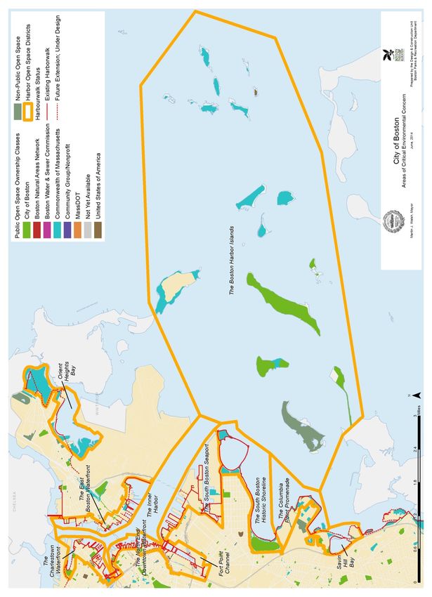
Section 7
Analysis of Needs

DISTRICTS

As a first step toward understanding the context and the
implementation of the above policies, this blueprint establishes
districts that encompass neighborhood-level open space
systems. The intention is to emphasize the distinct local
character that makes each area unique. Existing shoreline
features, neighborhood land uses, zoning boundaries, and
history of public use provide the context to delineate and
establish themes that characterize a particular district. The
framework establishes the following districts and themes:

• Orient Heights Bay:
  Creating New Linkages
• The East Boston Waterfront:
  Reclaiming an Historic Harbor
• The Charlestown Waterfront:
  Diversifying the Open Space Experience
• The North End/Downtown Waterfront:
  Realizing the Public Realm
• Fort Point Channel:
  Creating an Urban Water Park System
• The South Boston Seaport:
  Opening and Accessing a Renewed District
• The South Boston Historic Shoreline:
  Enhancing Olmsted’s Vision
• The Columbia Point Promenade:
  Linking Institutional Development
• The Savin Hill Bay Area:
  Creating Recreational Opportunities
• The Boston Harbor Islands:
  Building a User Base through Partnership

The range of these themes and corresponding districts asserts
the inherent character of an urban waterfront, reflecting the
diversity of the city with a rich and varied choice of physical
settings, cultural experiences, and recreational opportunities for
residents. Further community-based planning will seek to
blend neighborhood and citywide use, private development
and public access, and natural resources protection and
resource areas visitation.

Open Space Plan 2015-2021                  Page 7.1.2-4
City of Boston                             Harbor Open Space
Section 7
Analysis of Needs

Open Space Plan 2015-2021   Page 7.1.2-5
City of Boston              Harbor Open Space
Section 7
Analysis of Needs

CREATING NEW LINKAGES:
ORIENT HEIGHTS BAY

With the linking of Belle Isle Marsh and Wood Island Bay
Marsh to the Constitution Beach area, a series of complementary
open space experiences along Orient Heights Bay can become
accessible to all of East Boston. These connections would open
up new harbor recreation opportunities.

Recommendations
• Create a link between Constitution Beach and the Bayswater
   Street Urban Wild/Airport Buffer Project through a
   Harborwalk and/or public access path past the Orient
   Heights Yacht Club. Support the provision of a public
   docking pier at the Orient Heights Yacht Club.

• Complete the Narrow Gauge Link Pathway to provide
  access to Wood Island Bay Marsh from Constitution Beach
  as part of the East Boston Greenway expansion.

• Transfer the restored wetland at the Belle Isle Coastal
  Preserve to DCR for incorporation into the management of
  Belle Isle Marsh Reservation. Include a public access link via
  the East Boston Greenway to both the Bayswater Street
  Urban Wild and the Belle Isle Marsh Reservation.

• Implement the East Boston Greenway Access Plan
  recommendations for connecting the inland neighborhood to
  the Greenway in the sections from Neptune Road to Belle
  Isle Marsh.

• Develop a system of wayfinding and interpretive signage for
  this area’s growing system of harbor open space that is
  integrated with the Harborwalk signage system.

Open Space Plan 2015-2021                Page 7.1.2-6
City of Boston                           Harbor Open Space
Section 7
Analysis of Needs

RECLAIMING AN HISTORIC HARBOR:
THE EAST BOSTON WATERFRONT

East Boston's waterfront, for many decades neglected, is now
beginning to undergo a transformation. The efforts of partners
such as the Boston Natural Areas Network and Jeffries Point
residents have resulted in new open spaces along the
waterfront. During the past three years, the Boston Parks and
Recreation Department and the Massachusetts Port Authority
have made improvements to the neighborhood's open spaces.
As deteriorated or underutilized piers are redeveloped, an
active promenade will be created with active and passive
recreation, housing, and maritime industrial uses.

Recommendations:
• Extend the Harborwalk from Porzio Park in Jeffries Point to
   the Condor Street Overlook Urban Wild at the confluence of
   the Inner Harbor and Chelsea Creek. Use signage and
   landscaping to draw users to Harborwalk point access in
   maritime industrial areas. Develop an interpretive signage
   system to explain the maritime industrial and related uses,
   and integrate public art into these areas, much as has been
   done by Harbor Arts in the East Boston Shipyard.

• Restart Massport’s planning for the expansion (Phase II) of
  Piers Park. Support the BRA East Boston Master Plan
  recommendation to create a waterfront park at Pier 5 in
  concert with local residents and organizations. Work with
  the Parks Department on the linkage between Golden Stairs
  Terrace Park, the Rockies open space, Piers Park (Phases I
  and II), and Pier 5 open space development .

• Renovate Lewis Mall as a major landscaped pedestrian and
  water transportation connection from the Maverick Square
  neighborhood to the waterfront, and coordinate with the
  newly constructed Portside at Pier 1 project.

• Establish a pedestrian and bicycle connection between Piers
  Park (Phases I & II) and the first segment of the East Boston
  Greenway.

Open Space Plan 2015-2021                 Page 7.1.2-7
City of Boston                            Harbor Open Space
Section 7
Analysis of Needs

• Continue the East Boston Greenway northward from
  Bremen Street Park to enable better access to Piers Park and
  Harborwalk from inland neighborhoods.

• Support the East Boston Municipal Harbor Plan to create
  public parks and new Harborwalk segments as part of
  private development along the waterfront. Integrate such
  parks and rights-of-way into a cohesive waterfront open
  space system through each site’s design to ensure public
  accessibility visually as well as legally, and to provide
  activating destinations along the Harborwalk.

• Develop a “low tide trail” to connect Constitution Beach
  with “other than beach” access points, per the Metropolitan
  Beaches Commission’s 2014 report. Support capital
  improvements to allow better ADA and stroller access to the
  beach and to expand water-based activities such as boating
  and swimming through a floating dock and small boat
  storage and rental facility, per the Metropolitan Beaches
  Commission’s 2014 report.

Open Space Plan 2015-2021                Page 7.1.2-8
City of Boston                           Harbor Open Space
Section 7
Analysis of Needs

DIVERSIFYING THE OPEN SPACE EXPERIENCE:
THE CHARLESTOWN WATERFRONT

Charlestown’s waterfront from the Little Mystic Channel
through the historic Navy Yard to Paul Revere Park affords
unique opportunities for creating a variety of open space and
recreational uses on both land and water. Rich in history,
skirting a densely populated neighborhood, in close proximity
to downtown Boston, and with links to the DCR Charles River
Reservation, this area of Boston’s waterfront has the potential of
providing its open space users a diverse and enriching outdoor
experience.

Recommendations:
• Realize the potential of the Little Mystic Channel as a unique
   open space resource, building upon the new Harborwalk
   segments and the Weingarten Adaptive Sports and
   Recreation program for Spaulding Rehabilitation Hospital
   patients and others.

• Use signage and landscaping to draw users to Harborwalk
  point access, where possible, in maritime industrial areas.
  Develop an interpretive signage system to explain the
  maritime industrial and related uses

• Expand the Courageous Sailing Center facilities at Pier 4 and
  increase programming for Boston’s youth and new
  members.

• Support the BRA Charlestown Navy Yard Master Plan and
  Charlestown Navy Yard Waterfront Activation Plan which
  will create a public access and open space network that will
  reinforce the site’s unique historical character and common
  identity. . Improve the Harborwalk connection from Tudor
  Wharf along Constitution Marina and coordinate
  Harborwalk segments and signage with the National Park
  Service and the Massachusetts Port Authority.

• Support waterside infrastructure allowing public access to
  the water such as the Spaulding Rehabilitation Hospital’s
  adaptive marine program at Building 114, additional public

Open Space Plan 2015-2021                  Page 7.1.2-9
City of Boston                             Harbor Open Space
Section 7
Analysis of Needs

   touch and go docking facilities at marinas within the Navy
   Yard and water transit facilities at Piers 1 and 3.

• Support the development of the Maritime Interactive Park
  Network, a system of physical and programmatic maritime
  and historic interpretation to attract year-round use along
  Harborwalk and to protect public access.

• Study potential links to the Mystic River Trail System.

Open Space Plan 2015-2021                Page 7.1.2-10
City of Boston                           Harbor Open Space
Section 7
Analysis of Needs

REALIZING THE PUBLIC REALM:
THE NORTH END/DOWNTOWN WATERFRONT

The North End/Downtown waterfront has the most diverse
recreational and open space opportunities of any waterfront
neighborhood, including some of the highest concentrations of
active and passive open spaces and recreational facilities. Open
space mitigation efforts, as well as improvements by the
Department of Conservation and Recreation and the Parks and
Recreation Department, have resulted in attractive, well-used
public spaces along the waterfront.

Recommendations
• Support the completion of the remaining pedestrian bridge
   and open space mitigation commitments as part of the
   Central Artery Tunnel Charles River Crossing to integrate
   Boston Harbor with the New Charles River Basin park
   system and the Esplanade. Complete open space
   improvements on the south bank of the Charles River and
   the pedestrian bridge over the tracks at North Station that
   connects Charles River Basin Park system to the Harborwalk
   at Lovejoy Wharf.

• Continue the Harborwalk through all upcoming private
  wharf/waterfront developments. Ensure that public parks
  that are part of development sites’ designs are physically
  and/or visually linked to the Harborwalk and nearby
  streets.

• Improve Harborwalk conditions at Lewis and Union
  Wharves and complete Harborwalk connection along the
  north and southern sides of Commercial Wharf to Boston
  Yacht Haven.

• Provide, where appropriate, piers for docking with sewer
  pumpouts as part of the “No Discharge Area” designation.

• Unify the planned/completed pedestrian pathways and
  open spaces adjoining the waterfront with the Rose Kennedy
  Greenway. Support the BRA’s Crossroads Initiative work to
  link downtown to the Greenway and the waterfront and the
  Connect Historic Boston project to link the downtown’s
  transit to its historic resources.

Open Space Plan 2015-2021                 Page 7.1.2-11
City of Boston                            Harbor Open Space
Section 7
Analysis of Needs

• Support the development of the Historic Piers Network, a
  system of physical and programmatic historic interpretation
  to attract year-round use along the Harborwalk and to
  protect public access.

Open Space Plan 2015-2021               Page 7.1.2-12
City of Boston                          Harbor Open Space
Section 7
Analysis of Needs

CREATING AN URBAN WATER PARK SYSTEM:
FORT POINT CHANNEL

South Boston's Fort Point District has seen significant change,
with new open spaces, Harborwalk segments, and boat docks
along the channel. Amenities include interpretive signage,
public art, seating areas, and enhanced landscaping. Consistent
with the goals of the Fort Point Channel Watersheet Activation
Plan, a boat dock for non-motorized recreational boats, together
with new docks for water taxis and a new "Cultural Connector"
boat, make this area a truly urban water park area. The
renovation and expansion of the Boston Children's Museum,
together with the opening of the InterContinental Hotel and
Residences, Atlantic Wharf, and Commonwealth Ventures
properties have added open spaces and enhanced Harborwalk
segments by the Fort Point Channel, complementing
Harborwalk segments and open spaces created by the Central
Artery/Tunnel Project as part of its environmental mitigation
requirements.

Further anticipated improvements to the open space system
include the Harborwalk along the South Station Postal Annex
and proposed parks of the 100 Acres Master Planning Area and
public amenities in and along the Channel

Recommendations
• Establish a strong link on the cross-channel bridges between
   the Rose Kennedy Greenway and the enhanced Fort Point
   Channel through the Crossroads Initiative.

• Seek continued expansions of the water transportation
  system linking inner-harbor neighborhoods and, especially,
  waterfront attractions (museums, etc., (through the Cultural
  Connector boat service) which are accessible from the
  harbor. Support the BRA’s Inner Harbor Water
  Transportation Study recommendations for this area
  including service from the regional water transit terminal, to
  be constructed by the Massachusetts Department of
  Transportation at the InterContinental Hotel.

• Implement public amenities, including parks, community
  boating, watersheet sculpture garden, restaurants, etc. along

Open Space Plan 2015-2021                 Page 7.1.2-13
City of Boston                            Harbor Open Space
Section 7
Analysis of Needs
the Channel in accordance with the Fort Point Channel
Watersheet Activation Plan, the blueprint for this urban
water park.
• Support the development of the South Bay Harbor Trail
linking Fort Point Channel to the South End, Roxbury, and
the Fenway, as well as to the Southwest Corridor Park and
the Emerald Necklace.
• Work with the BRA to disperse funds from the development
of tidelands out of the South Boston Waterfront Account of
the Fund for Parks and Recreation to support open space
and recreational activation in the Fort Point District.
Support the Public Works Department’s efforts to
rehabilitate and restore the Old Northern Avenue Bridge, an
historic resource and vital pedestrian and bicycle connection
between the Rose Kennedy Greenway, Downtown
Waterfront, Fort Point District, and the South Boston
Waterfront/Innovation District.
• Support the development of the Historic Piers Network, a
system of physical and programmatic historic interpretation
to attract year-round use along the Harborwalk and to
protect public access.
Open Space Plan 2015-2021 Page 7.1.2-14
City of Boston Harbor Open SpaceSection 7 Analysis of Needs OPENING AND ACCESSING A RENEWING DISTRICT: THE SOUTH BOSTON WATERFRONT/INNOVATION DISTRICT Thanks to critical public projects such as the Moakley Federal Courthouse, the I-90 Connection to Logan Airport, the MBTA Silver Line, and the Boston Convention and Exhibition Center, a transformation of the South Boston Waterfront is well underway. This burgeoning area of the City will require the continued integration of industrial, commercial, residential, cultural, civic, and open space/recreational uses to form a lively district. Significant public planning has taken place for more than a decade to develop a framework for the current development projects in the district including Fan Pier, Seaport Square, and Pier 4. The Seaport Public Realm Plan, South Boston Waterfront District Municipal Harbor Plan, Commonwealth Flats Master Plan, and 100 Acres Master Plan have laid out a vision and a framework to guide developers, designers, and community preservationists. The waterfront will be made accessible to the public via a continuous Harborwalk and linked to an inland park system by tree-lined thoroughfares and other public amenities. The Harborwalk and inland park system will be supported by a variety of cultural and commercial uses, including the Institute of Contemporary Art, Boston Children’s Museum, and District Hall, to enliven and activate this area. Recommendations • Work to complete the Harborwalk public access network in the South Boston waterfront, including measures to assure broad public access from inland neighborhoods. Extend and connect the Harborwalk network from the Fan Pier and the Institute of Contemporary Art to Pier 4 and the pier buildings at Commonwealth Pier and the Boston Fish Pier. Consider where feasible further extensions or point access to the Boston Marine Industrial Park, to Dry Dock No. 3, and to the Reserved Channel, as well as connecting across the Summer Street Bridge to L Street Beach and Castle Island in the South Boston Historic Shoreline District. Encourage pedestrian links and view corridors to enable maximum public awareness and use of the Harborwalk. Use signage Open Space Plan 2015-2021 Page 7.1.2-15 City of Boston Harbor Open Space
Section 7
Analysis of Needs

   and landscaping to draw users through public access
   segments to the Harborwalk. Develop an interpretive
   signage system to explain the maritime industrial and
   related uses found in the District. Ensure adjacent ground
   floor uses are compatible with and encouraging of the
   public’s use of the Harborwalk. Develop implementation
   tools for the Seaport Public Realm Plan and the South Boston
   Waterfront District Municipal Harbor Plan urban design
   guidelines so as to assure human-scale development along
   pedestrian corridors to the Harborwalk.

• Encourage recreational use of the watersheet itself via
  zoning and planning tools, and the Chapter 91 tidelands
  regulations. Ensure these activities are available for
  patronage by the public. Support accessory land side uses
  such as boathouses, restroom facilities, fishing gear rental
  and sales, and associated food service to promote public use.

• Support active recreation uses in the parkland envisioned by
  the open space plans of both the Seaport Public Realm Plan
  and South Boston Waterfront District Municipal Harbor Plan
  at the southwest end of the Reserved Channel to ensure
  balanced recreation opportunities in the South Boston
  Waterfront District.

• Support the implementation and refinement of the
  recommendations contained in the BRA’s Seaport Public
  Realm Plan. Work through the implementation process
  (urban design guidelines, zoning amendments, etc.) to
  assure varied active and passive open space and recreation
  needs are met for present and future users.

• Support the development of the Historic Piers Network, a
  system of physical and programmatic historic interpretation
  to attract year-round use along Harborwalk and to protect
  public access.

Open Space Plan 2015-2021                Page 7.1.2-16
City of Boston                           Harbor Open Space
Section 7
Analysis of Needs

ENHANCING OLMSTED’S VISION:
THE SOUTH BOSTON HISTORIC SHORELINE

The rich history of this section of Boston’s shoreline can be the
central theme to guide the next phase of its revitalization. Fort
Independence has a military history going back to the 17th
century. Castle Island and Marine Park are the waterfront
segments of Olmsted’s vision for the 19th century. The history
of the 20th century recreation movement is reflected in the City-
improved facilities at the L Street Bathhouse and Joe Moakley
Park, further supporting this district’s historical theme.

The 1993 "Back to the Beaches" report by the city/state Joint
Commission on the Future of the Boston Harbor Beaches laid
the groundwork for the Department of Conservation and
Recreation's beach restoration projects. Two Metropolitan
Beaches Commission reports, in 2007 and 2014, reviewed
improvements which have been made to date, and suggested
additional initiatives to further enhance Carson Beach and
Pleasure Bay. Concerted regional access improvements must
also be made to these enhanced regional waterfront attractions.

Recommendations
• Continue to invest in improvements to the Castle Island area
   to enhance its use with an eye toward balancing local
   neighborhood and citywide visitation interests. Establish
   Castle Island as a museum and historical interpretative
   center. Increase the number of visitation days at Fort
   Independence.

• Provide Beach Shuttle bus connections from the UMass/JFK
  MBTA station to Carson Beach and Castle Island in
  accordance with the Back to the Beaches plan and the 2014
  Metropolitan Beaches Commission report, and extend bus
  service from Columbia Road to Carson Beach.

• Provide designated pedestrian-activated crossings from Joe
  Moakley Park to Carson Beach.

• Support ongoing water quality improvement efforts that
  sustain swimmable conditions in these waters.

Open Space Plan 2015-2021                  Page 7.1.2-17
City of Boston                             Harbor Open Space
Section 7
Analysis of Needs

• Provide designated pedestrian paths through a wayfinding
  system from Telegraph Hill and Independence Square to the
  shoreline.

• Support the recommendations of the Metropolitan Beaches
  Commission 2014 Report, including the creation of a
  “signature”bathhouse at Pleasure Bay, reuse of the “Pickle
  Jar” building, improved lighting along Day Boulevard, full
  signalization at the L Street intersections with Columbia
  Road and Day Boulevard, and pedestrian-activated crossing
  signals in front of the Curley Community Center.

Open Space Plan 2015-2021              Page 7.1.2-18
City of Boston                         Harbor Open Space
Section 7
Analysis of Needs

LINKING INSTITUTIONAL DEVELOPMENT:
THE COLUMBIA POINT PROMENADE

Columbia Point continues to evolve with a rich mix of residents,
students, workers, and visitors. During the past decade,
expansion of the John F. Kennedy Library and Museum,
construction of the new Edward M. Kennedy Institute for the
U.S. Senate, and implementation of UMass Boston's 25-year
Master Plan have brought thousands of additional visitors and
students to Columbia Point annually. Hundreds of residents,
including many long-time residents, live at Harbor Point
Apartments and the more recently-constructed Peninsula
Apartments. Additional housing is planned on Mt. Vernon
Street by Corcoran Jennison Companies.

Residents, students, workers, and visitors enjoy the local open
space system that takes advantage of the water's edge. The
Department of Conservation and Recreation's Old Harbor Park
at Harbor Point, built in the 1980s, was a key open space
amenity for residents. West Link followed in 2006, linking Old
Harbor Park to Carson Beach. More recently, new segments of
the Harborwalk, including at the Kennedy Library and a UMass
segment opening in 2015, will further enhance public access to
the water's edge. The Boston Redevelopment Authority's
pending re-design of Mt. Vernon Street will help increase inland
access to the waterfront.

Recommendations
• Reuse the Calf Pasture Pumping Station in concert with the
   needs of the public as well as its owner, UMass Boston, so as
   to provide a destination use and an activity node for the
   Columbia Point Promenade area.

• Support expansion of the UMass Boston Marine Operations
  Waterfront Recreation Program, which currently provides
  introductions to sailing, kayaking, and stand-up paddling
  from its Fox Point dock. Continue to support this program’s
  operation of Monday Lunchtime Harbor Cruises for the
  UMass population and the general public.

Open Space Plan 2015-2021                 Page 7.1.2-19
City of Boston                            Harbor Open Space
Section 7
Analysis of Needs
• Explore with the Department of Conservation and
Recreation the possible use of the John T. Fallon State Pier
located at the Kennedy Library and Museum for water
transportation to Columbia Point.
• Develop shuttle bus loops between the JFK Library and
Carson Beach/Castle Island via the JFK/UMass Red Line
station.
• Continue to link programmatically both the State Museum
and the University of Massachusetts to the waterfront open
space in this area including the Arts on the Point Project.
Advance the open space goals and objectives of the 2011
Columbia Point Master Plan as they relate to the waterfront,
including providing physical and visual links between key
open spaces and across Columbia Point to Boston Harbor;
developing a public open space system of active and passive
parks, squares and streets, connected to the water’s edge;
creating a sense of place along the waterfront with active
uses and amenities; and, preserving and enhancing public
access to the waterfront and activating the water’s edge.
Open Space Plan 2015-2021 Page 7.1.2-20
City of Boston Harbor Open SpaceSection 7 Analysis of Needs CREATING RECREATIONAL OPPORTUNITIES: SAVIN HILL BAY In the past decade, significant improvements have occurred at some of Dorchester's beaches, which are important and well- used assets for the community. Water quality is very high at Savin Hill Beach, and its walkways are well-maintained. Water quality improvements are still needed at Malibu and Tenean Beaches, where illegal sewer connections can drain into the harbor and limit the number of days that residents can safely swim and play at those beaches. Moreover, while Malibu Beach is easily accessible and well maintained, Tenean Beach is in need of repair, and has been damaged by storms and high tide. (While not part of the Savin Hill Bay district, connections to and improvement of Tenean Beach is mentioned here given the importance of connectivity to the success of the city’s harbor open space.) Recommendations • Develop Savin Hill Bay’s protected waters as an aquatic park for passive and active water-oriented recreation. • Enhance the developed Malibu Beach and supporting facilities by the provision of a dinghy dock and boat rental. • Support ongoing efforts to improve water quality at Savin Hill Bay and Malibu Beach. • Integrate McConnell Park with Malibu Beach and Savin Hill Bay by landscaped lawns and paths. • Support connecting Tenean Beach to Savin Hill Bay through the construction of a boardwalk along the Southeast Expressway embankment to Victory Road Park. • Identify new locations for public boat launching ramps. • Extend public access from McConnell Park via a boardwalk along the periphery of the expressway to connect the public beach at Clam Point. Open Space Plan 2015-2021 Page 7.1.2-21 City of Boston Harbor Open Space
Section 7
Analysis of Needs

• Support the connectivity recommendations of the 2014
  Metropolitan Beaches Commission report: “Increase public
  transit options and new connections between beaches in
  Dorchester and South Boston; provide connections to the
  Harborwalk, [beaches,] and the Neponset River
  Greenway/Trail from neighborhoods that are not directly
  contiguous, such as Bowdoin/Geneva, Fields Corner, Clam
  Point, Popes Hill, Codman Square, Ashmont, and Lower
  Mills. Strengthen connections to the waterfront … at UMass
  Boston and Columbia Point; consider a potential
  transportation partnership with UMass Boston and a
  seasonal shuttle from Franklin Park down Columbia Road.”

• Support capital and other recommendations of the 2014
  Metropolitan Beaches Commission report, such as a redesign
  and redevelopment of Tenean Beach, a new bathhouse at
  Savin Hill Beach, sediment dredging for improved water
  flow and quality, beach connections for cyclists and
  pedestrians, boat/kayak rentals, and more
  concessions/food trucks.

• Complete Harborwalk links along Port Norfolk linking
  Tenean Beach with Port Norfolk Park, Pope John Paul II
  Park, and the Neponset River Greenway

Open Space Plan 2015-2021              Page 7.1.2-22
City of Boston                         Harbor Open Space
Section 7
Analysis of Needs

BUILDING A USER BASE THROUGH PARTNERSHIP:
THE BOSTON HARBOR ISLANDS

With the success of the Boston Harbor Cleanup Project, the 2006
opening of the restored Spectacle Island to the public, and the
2011 opening of a visitor pavilion on the Rose Kennedy
Greenway, the Boston Harbor Islands National Recreation Area
(BHINRA), with its 34 islands and peninsulas, continues to
attract a growing number of visitors (18 of the 34 islands are
within Boston city limits). This is one of America’s few urban
national recreation areas. The Boston Harbor Islands
Partnership consists of the owners, including city, state and
federal governments, and two non-profit organizations, who
manage the park. The City of Boston Parks and Recreation
Department and the state's Department of Conservation and
Recreation own Spectacle Island, a major hub to the rest of the
islands.

Six islands, including Spectacle, Georges, Peddocks, Lovells,
Grape, and Bumpkin are serviced by public ferry. Spectacle,
Georges, and Peddocks Islands have visitor/welcome
centers. Some of the more rustic islands, such as Peddocks,
Bumpkin, Grape, and Lovells, offer camping experiences,
including yurts on Peddocks Island for less seasoned campers.
Free daily programs on the islands make them one of the most
popular visitor destinations in the state.

The recently built Camp Harbor View, on the City-owned Long
Island, affords inner city kids the opportunity through summer
camps to experience this Distinctive Landscape (as designated
by the state Department of Conservation and Recreation in its
Scenic Landscape Inventory) as do more affluent visitors.

The Boston Harbor Islands, though beloved and enjoyed by
many, are isolated and buffeted by their aquatic setting, making
them among the most fragile and vulnerable resources in
Boston’s open space system. Continued investment in this
national recreation area is needed, especially in light of
predicted sea level rise and extreme storm events.

Open Space Plan 2015-2021                 Page 7.1.2-23
City of Boston                            Harbor Open Space
Section 7
Analysis of Needs

Recommendations

• Support the Camp Harbor View program to give inner city
  kids opportunities to experience the harbor environment at
  the summer camp grounds on Long Island.

• Build upon the success of the Island Alliance and National
  Park Service’s $4 million Harbor Islands Pavilion on the
  Rose Kennedy Greenway, and work to enhance wayfinding
  from the Greenway to the Long Wharf water transportation
  gateway to the Harbor Islands.

• Work with the University of Massachusetts and the Kennedy
  Library on the development of a Dorchester-based gateway
  to the Harbor Islands, and with Fan Pier developers on the
  implementation of a Harbor Island gateway in the South
  Boston Seaport District in accordance with the South Boston
  Waterfront District Municipal Harbor Plan.

• Support ferry service from Lynn, Squantum Point in Quincy,
  and Point Allerton in Hull to the BHINRA as recommended
  by the 2014 Metropolitan Beaches Commission Report to
  diversify the visitor base.

• Support the recommendations of the 2014 Metropolitan
  Beaches Commission Report to remediate the asbestos at
  Gallops Island, invest in the Georges Island marina and
  terminal, and dredge the marina area of Spectacle Island.

• Document and map all conservation lands on the islands,
  specify those of critical environmental concern, and develop
  a natural resource protection plan for their permanent
  maintenance. Continue to separate these lands from
  recreational and intensive use areas.

• Continue the City’s stewardship plan for Rainsford Island,
  including an archaeological reconnaissance-level survey, to
  identify cultural and natural resources and formulate
  recommendations for protection and use.

Open Space Plan 2015-2021                Page 7.1.2-24
City of Boston                           Harbor Open Space
You can also read


