Anglin Dairy Major General Plan Amendment - JULY 15, 2020 - Maricopa-AZ.gov
←
→
Page content transcription
If your browser does not render page correctly, please read the page content below
Anglin
 Dairy
 Major General Plan
 Amendment

JULY 15, 2020

Prepared by:
RVi Planning + Landscape Architecture
120 S Ash Avenue, Tempe, AZ 85281

                                  1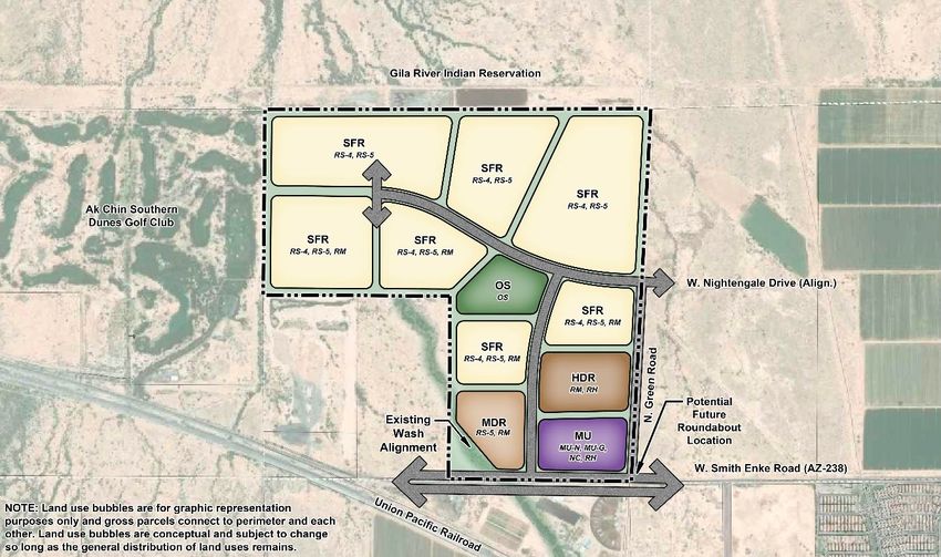
Development Team

PROPERTY OWNER
Contact: Richard Anglin
DA Holdings, LLC
22272 N. Green Road
Maricopa, AZ 85139

APPLICANT
Contact: Mark Reddie
RVI Planning + Landscape Architecture
120 S. Ash Avenue
Tempe, AZ 85281
(480) 994-0994
mreddie@rviplanning.com

LAND BROKER
Contact: Bret Rinehart
Land Advisors Organization
4900 N. Scottsdale Road, Suite 3000
Scottsdale, AZ 85251
(480) 874-4306
brinehart@landadvisors.com
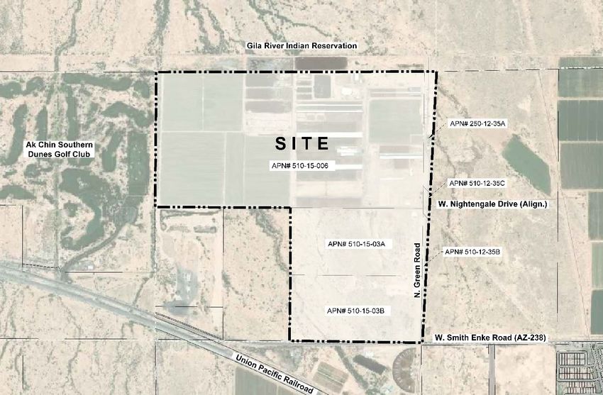
Table of Contents
1. Description of the Request ...............................................................................................................................2
   A. Proposed Amendment ............................................................................................................................................. 2
   B. Reasons for the Request .......................................................................................................................................... 2
   C. Supporting Key Points ............................................................................................................................................. 2
2. Site Context Study .............................................................................................................................................5
   A. Site Location .............................................................................................................................................................. 5
   B. Site Context ................................................................................................................................................................ 5
   C. Existing Site Conditions ........................................................................................................................................... 6
3. Land Use Analysis ..............................................................................................................................................7
   A. Existing Land Use ...................................................................................................................................................... 7
   b. Proposed Land Use................................................................................................................................................... 8
   C. Conceptual Development plan .............................................................................................................................. 9
       Land Use ................................................................................................................................................................... 10
       Land Use Compatibility ......................................................................................................................................... 11
       Circulation ................................................................................................................................................................ 11
       Open Space .............................................................................................................................................................. 12
       Phasing...................................................................................................................................................................... 12
       Growth Area ............................................................................................................................................................. 12
       Public Services ......................................................................................................................................................... 13
   B. Public Benefit of the proposed amendment. .................................................................................................... 13
4. Conclusion ....................................................................................................................................................... 15

       Anglin GPA                                                                                                                                                          Page 1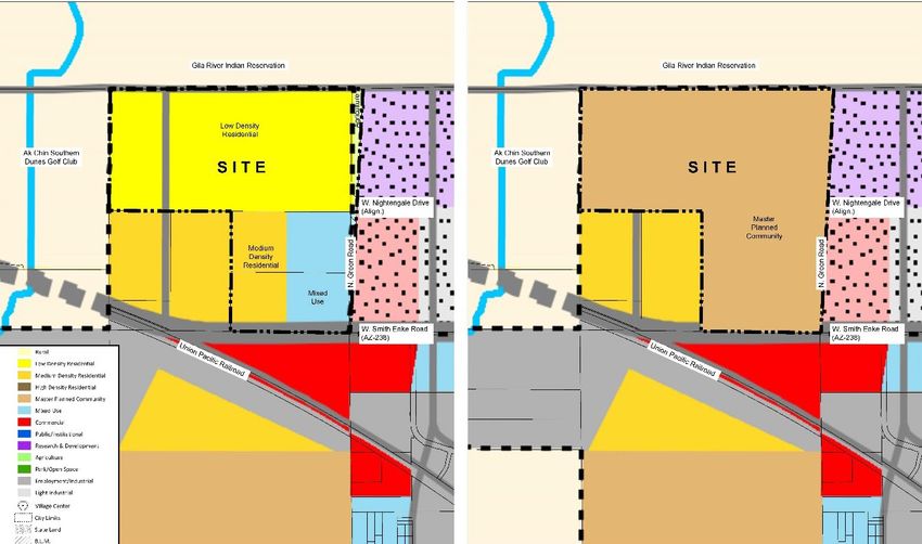
1. Description of the Request
  A. PROPOSED AMENDMENT
  This Major General Plan amendment request seeks to modify the General Plan land use designation
  for the approximately 493.71-acre subject property (“the Property” or “Site) located at the northwest
  corner of Smith Enke Road (SR-238) and Green Road in Maricopa, Pinal County, Arizona. The Property
  is currently being utilized as a working dairy and is designated with a mix of L (Low Density Residential),
  M (Medium Density Residential), MU (Mixed-use) and A (Agriculture) on the Maricopa General Plan Land
  Use Map. This request seeks to amend the Property’s land use designation to MPC (Master Planned
  Community). This request is consistent and compatible with surrounding development patterns
  within the community and is a more suitable land use than the Site’s current use. In addition, absent
  this amendment, the dairy is more likely to continue in operation on the site, creating increased risk of
  incompatibility with nearby residential and commercial areas currently awaiting development.

  B. REASONS FOR THE REQUEST
  The purpose of this request is to support the transition of the Site from its use as a dairy and farming
  operation to a mixed-use master planned development that will include a mix of residential densities
  and that will allow for supporting commercial and employment land uses as warranted. While
  residential and mixed-use uses are allowed under the site’s current general plan land use designations,
  the MPC designation provides the site plan flexibility that today’s developers are looking for. Within the
  MPC designation, land use and density decisions can be creatively and flexibly designed rather than
  be determined by hard, existing land use delineations that don’t have a specific development or design
  basis. The MPC land use designation will allow the site to transition from its current use and develop
  as a dynamic mixed-use master-planned community that will help address the City of Maricopa’s
  existing and future housing needs, while also providing opportunities for commercial and employment
  uses as demand warrants.

  C. SUPPORTING KEY POINTS
  The following key points support this General Plan Amendment request:

      1. The Site currently contains a mix of L (Low Density Residential), M (Medium Density
         Residential), MU (Mixed-use) and A (Agriculture) land use designations with relatively arbitrary
         delineations between uses. Amending the Site to the MPC designation will establish a more
         unified and appropriate land use designation, while allowing a developer to creatively design
         a master planned community that provides for a thoughtful, well designed approach without
         the constraints of hard land use delineations driving the division of uses and densities.

  Anglin GPA                                                                                         Page 2
2. The Site is surrounded by a variety of uses including an existing golf course to the west and
planned commercial and employment uses south and east of the Site. The land north of the
Site is vacant and is part of the Gila River Indian Community. The MPC land use is compatible
with these surrounding land use patterns and represents an appropriate land use within its
context.
3. While the residential and supporting commercial and employment uses allowed under the
MPC land use designation are all currently allowed under the Site’s existing land use
designations, the MPC allows for greater flexibility and creativity is the overall community
design. Rather than having land uses be defined by hard, arbitrary boundaries, the MPC
designation allows for wholistic design that thoughtfully addresses the land use, circulation,
and open space needs of the future community.
4. Currently the site contains approximately 79 acres designated for mixed-use. This large mixed-
use area is out of character with surrounding development patterns and is better suited to
more centralized locations within the City, including the Village Centers and Heritage District,
where these types of developments are more likely to succeed and thrive. The Conceptual
Development Plan provided as part of the MPC land use approach is shown as Figure 3, and
anticipates a MU (Mixed-use) parcel at the hard corner of Green Road and Smith Enke Road
(SR-238), as well as high density multi-family uses surrounding the mixed-use parcel, providing
an appropriate mix of higher density uses where most visible and accessible, and transitioning
to more traditional single family residential for the remainder of the development. The benefit
of the MPC designation is that the precise size, location and configuration of this mix of uses
can be determined through the zoning process closer to the time of actual development, as
opposed to prematurely speculating with the General Plan, with is too early in the
development process to accurately lock in this level of detail.
5. Based on current/recent growth patterns and demand for new development in this
designated growth area, the dairy is becoming a non-compatible land use with the growing
residential population and planned future commercial and employment development in the
immediate area. Amending the Site’s land use designation to MPC will facilitate a quicker
transition of the Site away from the dairy uses and allow flexibility to adapt to market demand
for an appropriate mix of uses.
6. While the entire site is being proposed as MPC, a Conceptual Development Plan is included
with this request to demonstrate one potential concept for the future development of the site.
The Conceptual Development Plan identifies a mix of uses including mixed-use, high density
residential, medium density residential, single-family residential and open space. While this
demonstrates one potential concept for the site, the concept can change through the rezoning
process so long as the general mix of uses is consistent. In accordance with General Plan Goal
B2.2, diverse housing stock in both dwelling type and density is required within the project,
Anglin GPA Page 3with higher density housing and mixed-use located along the Site’ southern Smith Enke Road
(SR-238) frontage transitioning to lower density housing along the Site’s north boundary.
7. The City of Maricopa General Plan Goal B1.3 describes the importance of incorporating mixed-
use and neighborhood commercial uses for creating full master planned communities. Mixed-
use communities can permit developments within increased building heights and densities to
create a more sustainable and pedestrian-oriented form. Mixed-use districts also can provide
a variety of commercial and retail spaces to expand opportunities for small businesses. With
approximately 20-acres of mixed-use strategically located at the primary intersection of Smith
Enke Road and Green Road in a highly visible and accessible location for both future residents
and visitors to the development, this request supports the goals and objectives of this section
of the General Plan.
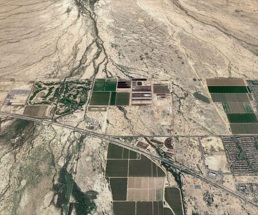
Anglin GPA Page 42. Site Context Study A. SITE LOCATION The Site is located at the northwest corner of Smith Enke Road (SR-238) and Green Road, approximately 1.5 miles west of SR-347 in the City of Maricopa, Pinal County, Arizona. The Site is approximately 493.71-acres in size and consists of 6 parcels, APN#s: 510-15-006, 510-15-003A, 510-15- 003B, 510-12-035A, 510-12-035C & 510-12-035B. See Exhibit 1: Site Context Study, below. Figure 1: Site Context Study B. SITE CONTEXT The property is currently zoned “CI-2 Industrial”, within the City of Maricopa. This zoning designation was implemented subsequent to the property being annexed from Pinal County into the City. The Site is planned to be rezoned if the proposed General Plan Amendment approved by the City Council. Surrounding zoning consists of CR-3 to the east and CI-2 to the south. The Gila River Indian Reservation is located immediately north and west of the property and the area east of the Site is State Trust Land. A summary of the surrounding general plan, zoning, and land uses is provided in Table 1: Surrounding Property Designations. Anglin GPA Page 5
Table 1: Surrounding Property Designations
 Location         General Plan       Zoning               Land Use
 Site             L, M, MU & A       CI-2                 Active Dairy and Farming Operation
 North            N/A                N/A                  Vacant land that is part of the Gila River
                                                          Indian Reservation
  South             I                    CR-3             Smith Enke Road (SR-238) and an
                                                          active Farm
  East              N/A                  N/A              Ak Chin Southern Dunes Golf Club
  West              N/A                  C1-2             Vacant State Trust Land
Given the varying land uses surrounding the Site, care must be taken to establish a harmonious
transition of land uses. Section 3c of this document addresses the design intent and approach the
Conceptual Land Use Plan minimizes potential conflicts between land uses.

C. EXISTING SITE CONDITIONS
The Property is currently home to an active dairy and farming operation. The property is relatively flat
and generally drains from North to South. There are no major roadway improvements on the property,
and the only significant site characteristic is a major wash corridor at the Site’s southwest corner near
Smith Enke Road (SR-238). Lands surrounding the Property consist of agricultural-related uses and
small-scale industrial uses. A golf course is located immediately west of the property. The western
portion of the property is currently located within a floodplain, therefore a CLOMR is required for the
development of the project site and will be processed prior to any proposed development occurring
as required. Over the course of subsequent development applications, including a detailed drainage
report among other necessary infrastructure studies, all floodwater regulations will be met in
accordance with the Environment Element of the General Plan.

Access to the property is off Smith Enke Road (SR-238) and Green Road. Smith Enke Road (SR-238) is
classified on the City’s General Plan Circulation Map as a “Freeway” and connects SR 238 to SR 347.
Smith Enke Road (SR-238) primarily serves through traffic rather than local traffic. Green Road is not
shown on the City’s General Plan Circulation Map but currently exists as a dirt road with no formal
street improvements. It is anticipated that Green Road will be improved as a “Collector” from Smith
Enke Road (SR-238) to the future community entrance as the Site develops.

Anglin GPA                                                                                        Page 6
3. Land Use Analysis
A. EXISTING LAND USE
The Site currently includes a variety of land use designations including A (Agriculture), L (Low Density
Residential, M (Medium Density Residential) and MU (Mixed-use). A description of these areas and the
acreage of the Site designated for each is provided in Table 2: Existing Land Use Designations, below.
Table 2: Existing Land Use Designations
Land Use Approx. Description (Per the City of Maricopa’s General Plan)
Designation Area
A– 6 Acres The Agriculture category recognizes farming and other agriculture as one of the
Agriculture principle land uses in the planning area. Agricultural uses have impacts to
immediately adjacent properties making lower intensity land uses such as large
lot, single-story residential appropriate transitions adjacent to agriculture. The
density range of this category, in accordance with statutory requirements, is up to
1 residence per acre; however, the continuation of lower densities as required by
existing zoning is supported.
L – Low 329 Acres The Low-Density Residential designation accommodates semi-rural large lot
Density development with generous distances to streets and between residential dwelling
Residential units and a viable semi-rural character setting. Limited livestock privileges may be
a part of this character for areas where lot sizes are a minimum of one acre. Areas
in this category are generally larger lots with accessory structures that may be
used for animals. The maximum density for this land use category is 2.0 dwelling
units per acre (du/ac).
M – Medium 79 Acres The Medium Density Residential category provides for a suburban lifestyle with
Density planned, single-family residential neighborhoods, which include significant open
Residential space, recreation and cultural opportunities, including schools, churches and
neighborhood facilities. Medium density residential developments are expected
to contribute to off-site infrastructure needs for which they create a demand
including roadways, bridges and grade separated crossings. Medium density
residential areas comprise the majority of residential land in the City. The density
of this land use category is between 2.0 to 6.0 du/ac.
MU – Mixed- 79 Acres The Mixed-use designation is intended to foster creative design for developments
use that desire to combine commercial, office and residential components. Single
use projects are discouraged in the MU designation. Proposed MU projects
should provide a true combination of uses that inter-relate in design and function
with a pedestrian oriented environment. Higher density residential products
(such as apartments and condominiums), 8.0 or more dwellings per acre, are
expected in Mixed-use projects.
Anglin GPA Page 7B. PROPOSED LAND USE
This application is for a Major General Plan Amendment to change the Site’s land use designation from
the above-mentioned land use designations to MPC (Master Planned Community) across the entirety
of the site. As described in Table 3: Proposed Land Use Designation, below, the MPC district allows for
land-scale master planned developments that include a variety of residential products along with
supporting commercial and employment land uses to meet the daily needs of residents. Additional
uses appropriate for this land use designation include open space, schools, churches, and
neighborhood facilities. The MPC land use designation serves as a broad land use designation that can
accommodate a variety of uses and residential densities to support vibrant communities within the
City of Maricopa. The MPC district allows for master planned communities that take a wholistic view of
the Site providing for comprehensive pedestrian and vehicular circulation, open space, infrastructure,
and land use plans to guide development across the Site.
Table 3: Proposed Land Use Designation
Land Use Approximate Description (Per the City of Maricopa’s General Plan)
Designation Area
MPC – 493-Acres The Master Planned Community designation provides for large-
Master scale (160 acres or more) master planned developments that
Planned include a true variety of residential products, including larger lots
Community and smaller, attached housing, along with supporting commercial
and employment land uses to meet the daily needs of the residents.
Residential areas are to include adequate open space, schools,
churches and neighborhood facilities. Overlay zoning in
combination with comprehensive site planning provide for
supporting infrastructure. MPC developments are expected to
provide off-site infrastructure enhancements as necessary to offset
development impacts including needed roadway, bridge and
overpass capacity. The overall density is flexible to allow
appropriate urban design for properties designated for Village
Center. Overall densities for all residential dwellings in MPCs
without a Village Center designation can range from 3.0 to 10.0
dwelling units per acre.
Anglin GPA Page 8Figure 2: Existing & Proposed Land Use Map provides a visual depiction of the existing and proposed land uses on the Site. Figure 2: Existing & Proposed Land Use Map C. CONCEPTUAL DEVELOPMENT PLAN The MCP land use district allows for a mix of land uses within the overall master planned community. While the Site will ultimately be designed based on developer needs and market conditions, it is likely to include a set of common elements as shown in Figure 3: Conceptual Development Plan. This plan has been provided to serve as a general guide for how the Site could develop under the MPC land use designation. It depicts conceptual roadway access points, circulation routes, land uses, proposed zoning designations (identified in italics) and conceptual open space areas. The Conceptual Development Plan is conceptual and subject to change, so long as the intent of the overall land use designations are maintained. Specific details of land uses, residential densities, and proposed zoning districts will be addressed during the future rezoning case. Anglin GPA Page 9
Figure 3: Conceptual Development Plan

  Land Use

  The site’s current land use designations allow for low, medium, and mixed-use residential
  development with very specific and somewhat arbitrary boundaries. All of these uses are will be
  maintained under the MPC land use designation as indicated in the Conceptual Development Plan,
  but with more flexibility for where each is located, including the general mix of uses, densities and
  intensities. The flexibility of the MPC designation, with a Conceptual Development Plan to reference
  as an example of the potential mix, will allow for more integration and flexibility than pre-
  designating hard land use boundaries now for a community that has not yet been designed. The
  Conceptual Land Use Plan identifies a variety of land uses, densities and intensities, including:

             SFR (Single-Family Residential) – RS-4, RS-5, RM
             MDR (Medium-Density Residential) – RS-5, RM
             HDR (High-Density Residential) – RM, RH
             MU (Mixed-use) – MU-N, MU-G, NC, RH
             OS (Open Space) – OS

  The Conceptual Land Use plan anticipates a mixed-use parcel at the primary intersection of Green
  Road and Smith Enke Road (SR-238) where the highest access and visibility will occur, with HDR
  and MDR uses surrounding the MU parcel, serving as a buffer and transition to the SFR and OS
  parcels making up the remainder of the site. SFR parcels will range in density and will likely
  transition from higher densities at the south of the Site to lower densities at the north of the Site.
  The OS parcel will generally be centrally located to be highly visible and readily accessed by the
Anglin GPA                                                                                     Page 10
community’s future residents. The MPC land use designation allows for overall residential densities of between 3 and 10 dwelling units to the acre when averaging throughout the development. It is anticipated that the overall density for this Site will be around 5 +/- dwelling units to the acre. The additional residential density located adjacent to the mixed-use parcel planned for the southeast corner of the Site has been strategically placed to support the possible neighborhood commercial uses within the mixed-use parcel and to promote their commercial viability and walkability. Locating the mixed-use parcel at the primary intersection improves its viability by not only providing support and walkability to the residents within master planned community, but by also providing regional visibility and access to other nearby properties. Together the residential and commercial uses create a symbiotic relationship encouraged within the General Plan and essential to successful master-planned communities. Land Use Compatibility Goal B.4 of the General Plan stresses the importance of minimizing conflicts between land uses. The Site’s current use as a dairy is not conducive to future development surrounding the Site. The Conceptual Development Plan has been designed to establish more compatible land uses and to ensure a compatible transition of land uses across the Site. The Project’s land uses generally transition in intensity from south to north with higher-intensity uses including mixed-use and high- density residential located along Smith Enke Road (SR-238) at the south of the site to lower density single-family residential uses along the Site’s north boundary adjacent to the Gila River Indian Reservation. This is in keeping with Goal B.4 of the General Plan which discourages residential development along high capacity roadways, and also with Goal B1.4 which encourages appropriate buffer and lower density/intensity land uses along Native American Community boundaries where appropriate. Circulation Site Access will be provided from Smith Enke Road (SR-238) and Green Road. Green Road will extend north to the intersection of W. Nightingale Drive, where it will terminate at a future collector road to the east into the ASLD property and to the west into the Site. The City of Maricopa is currently working with ADOT on refining the planning of the Smith Enke Road (SR-238) corridor. The City and ADOT support a possible roundabout at the intersection of Smith Enke Road (SR-238) and Green Road that would be able to accommodate truck and trailer traffic. It is understood that a condition to preserve right of way for a roundabout may be a future condition of further applications. A central collector street will provide east/west access along the Vinyard Road alignment into the property and will terminate before reaching the western edge of the site since an existing golf course will prevent access further west. Anglin GPA Page 11
A second north/south collector road will be provided along Smith Enke Road (SR-238) at the ¼ mile
  alignment and will connect to the Nightingale Road alignment internal to the Site. The purpose of
  the north/south collector road being at the ¼ mile alignment is due to the major wash corridor that
  runs parallel to the property along the ½ mile alignment through the property. This would make
  the roadway alignment extremely expensive and difficult to construct, including installation of
  several culverts, bridges, and extensive engineering improvements to cross it, not to mention the
  impacts to the overall drainage channel along this alignment.

  No road improvements are planned along the Site’s north and western borders.

  Pedestrian circulation and connectivity will be provided within and between each development
  parcel in accordance with the City’s General Plan and Zoning Ordinance policies and guidelines. In
  accordance with the General Plan, a regional trail corridor is identified along the northern boundary
  of the project, adjacent to the Gila River Indian Community and along western edge of the Site.

  Open Space

  The Conceptual Development Plan includes a central major open space area to be utilized as either
  a public or private park. This centralized open space will include both active and passive recreation
  amenities including elements such as picnic areas, sport courts, play areas, and walking trails.

  In addition to the central major open space area, smaller neighborhood parks will be provided
  within each residential development parcel to facilitate community gather, recreation and
  engagement with the outdoors. Additional open space areas will be provided for drainage and
  retention areas as well as buffering along major roadways and between uses. Open Space areas
  will be provided within and between each development parcel in accordance with the City’s
  General Plan and Zoning Ordinance policies and guidelines.

  The Vekol wash crosses the Site’s southwest corner. In accordance with the Environmental
  Element of the General Plan, This wash corridor will be designed to incorporate some natural
  elements, and will include paths for connectivity, direct pedestrian access to the abutting
  residential development parcel, view corridors from public spaces and will serve as habitat and
  migration corridors for native wildlife.

  Phasing

  Phasing has not yet been determined, but each phase will provide all necessary infrastructure and
  utility requirements as necessary to support the development.

  Growth Area
  The Site is located within an identified Growth Area as mapped within the General Plan. This
  application is a compliment to the City’s Growth Strategy. The Growth Area element of the General
  Plan contemplates for commercial/employment and residential growth. Both uses are

Anglin GPA                                                                                    Page 12
incorporated within the proposed Conceptual Development Plan. Objective A2.1 supports land
   use requests that improve the balance between housing and employment within the Maricopa
   Planning area. With a combination of residential and mixed-use land uses on the Site, this
   application meets the intent of this objective.

   The Economic Development Element of the General Plan envisions Maricopa as a fully integrated
   municipal economy providing opportunities for residents to live, work and play. While the General
   Plan identifies SR-347 as the City’s primary “economic conduit” for the community, commercial and
   employment development is envisioned along Smith Enke Road (SR-238) as well. The City-planned
   Estrella Gin site is located along Smith Enke Road (SR-238) and anticipates significant light
   industrial development as does the research and development office complex situated in the
   Redevelopment Area near the Site. This application is a complement to these two employment
   developments in that it proposes a Master Planned Community featuring both residential and
   mixed-use neighborhood commercial uses that provide a mix of land uses within this area of the
   City.

   Public Services
   Goal 5.1 of the Maricopa General Plan is to “Ensure new development provides the resources to
   establish the infrastructure to serve that development”. In line with this goal, the Anglin
   development will be responsible for securing and constructing all required infrastructure to
   support the development. Global Water is anticipated to be the water and wastewater service
   provider for this site. In preliminary discussions with Global Water, they have indicated their desire
   to expand their service area to include this project. Further negotiations with them and other utility
   providers will be ongoing.

   Goal H2.G.2 of the Maricopa General Plan is to “Actively coordinate with local school districts,
   charter schools, and institutions of higher learning in the planning, construction and rehabilitation
   of facilities”. The Site is located within the boundaries of the Maricopa Unified School District. In
   accordance with the above General Plan goal, the development team has reached out the Maricopa
   Unified School District notifying them of the proposed project and will continue to be in
   communication with them as the project advances to future stages of the development process.

B. PUBLIC BENEFIT OF THE PROPOSED AMENDMENT.
This General Plan Amendment request includes the following public benefits:

   1. The Site is located within a “Growth Area” as identified within the City’s General Plan. Growth
      Areas are defined as being essential to achieving a sustainable balance of land uses and to
      sequencing how growth and development occurs. With its associated environmental hazards
      including odor, noise and pollution, the existing dairy use is an inhibitor to growth within this
      area of the City. Areas surrounding the site are planned for a variety of open space, residential,
      commercial, and employment uses. Dairy’s typically are not good neighbors to these types of

Anglin GPA                                                                                      Page 13
uses. Amending the Site’s land use designation to MPC will allow for a speedier transition away
from the dairy use. In doing so, the request furthers the goals of the General Plan by providing
compatibility among various land uses and current growth patterns.
2. The majority of the Site, approximately 329-acres, is currently designated for L (Low Density
Residential). The L designation allows for a maximum of 2 dwelling units per acre. The MPC
designation allows for 3-10 dwelling units per acre. Amending the Site’s land use designation
to MPC will allow for the development of a greater variety of residential densities on this Site
which will better address the City of Maricopa’s current and future housing needs.
3. The site’s current land use designations include a mix of L (Low Density Residential), M
(Medium Density Residential), MU (Mixed-use) and A (Agriculture). The MPC (Master Planned
Community) designation anticipates similar land uses but allows for greater flexibility in where
each land use is located across the site and allows greater consideration of how the land uses
interact with each other. The MPC land use designation will allow for a more thoughtful,
wholistic land use design for this community creating a more desirable and cohesive overall
community design.
4. The proposed Mixed-use designation shown on the Conceptual Development Plan will offer
the surrounding community opportunities for additional uses to traditional single family, such
as high density residential, commercial and employment uses that can offer alternative
residential lifestyles as well as local commercial and employment uses to serve the
surrounding population and spur additional economic development within this area of the
City.
5. Future development of the Site under the MPC designation will include circulation, open
space, and infrastructure improvements as required with the City. These improvements will
help to encourage additional development within this area as the City continues to grow and
expand.
Anglin GPA Page 144. Conclusion This Major General Plan Amendment is being requested to change the Site’s land use designation from a mix of L (Low Density Residential), M (Medium Density Residential), MU (Mixed-use) and A to MPC (Master Planned Community). As demonstrated within this narrative, this Amendment request is an appropriate and compatible change to the General Plan Land Use Map. This request will ultimately allow the Site to develop with a mix of residential densities and land uses. The MPC designation will contribute to the City’s community fabric and allow the City to grow in a sustainable and compatible way that will preserve the area’s character and will maintain Maricopa’s unique quality and character, while advancing the goals and policies of the General Plan. This request will allow the approximately 493.71-acre Property to more expediently transition from its current agricultural use as a dairy, which could be detrimental to surrounding development, to a residential neighborhood with supporting commercial and employment uses which is more consistent and compatible with surrounding development patterns and which will be a net benefit to the overall community. We look forward to working with the Town of Maricopa to implement this vision for the Site. Anglin GPA Page 15
You can also read