Animal Surveillance Quadcopter Using Thermal Imaging - De La Salle ...
←
→
Page content transcription
If your browser does not render page correctly, please read the page content below
Arts and Culture: Heritage, Practices and Futures

Presented at the 11th DLSU Arts Congress
De La Salle University, Manila, Philippines
February 7 and 8, 2018

             Animal Surveillance Quadcopter Using Thermal Imaging
                           Joseph Emmanuel Figueroa, Jilliane Marie Mendoza,
                    Katrina Siccion, Christine Hazel Soliman, and Engr. Donabel Abuan

                                               joseph_figueroa@dlsu.edu.ph
                                              jilliane_mendoza@dlsu.edu.ph
                                               katrina_siccion@dlsu.edu.ph
                                              christine_soliman@dlsu.edu.ph
                                               donabel.deveas@dlsu.edu.ph

          Abstract: Wildlife is present in all of the different ecosystems. From deserts, to
          forests, and even places where urban sites are developed, all have particular types of
          animal life. Researches show that as the population of man and their necessities
          grow, they are leaving less and less space for the wildlife. This inversely proportional
          relationship gives off multiple threats for the latter. As a matter of solving this
          problem, a has proved that aerial drones, when compared to the traditional ground-
          based methods, are actually far better in performing monitoring operations that
          would also include wildlife monitoring. This dissertation will be making use of a
          thermal camera mounted on to a quadrotor to create a system that would be able to
          detect the presence of animals in their own habitat. In this implementation, image
          processing will also be used to provide observations of animal presence into the
          system.

          Key Words: Tensorflow - open source library dedicated for machine learning;

1. INTRODUCTION
1.1 Background of the Study
         Wildlife is present in all of the different ecosystems. From deserts, to forests, and even places
where urban sites are developed, all have particular types of natural life. Although the term
“wildlife” traditionally alludes to creatures that are untouched by human factors, some animals have
already adapted to rural situations. This incorporates such creatures as cats, dogs, gerbils, and many
other animals that are considered tamable. With this in mind, most researchers concur that much
natural life is influenced by human activities.
         Nature conservation is the act of securing plants, animal species and their habitats that are
in danger of extinction. For an effective nature preservation approach, information with regards to
the conceivable dangers to plants and animals is a necessity. Such dangers can be partitioned into
three classifications, specifically, disease, poaching, and habitat loss. With this in mind, further
prevention of these problems can be practiced by monitoring the behavioral number of the animals.
[1]
         As a matter of solving this problem, a study in 2016 led by Dr. Rohan Clarke has proved that
aerial drones, when compared to the traditional ground-based methods, are actually far better in
performing monitoring operations that would also include wildlife monitoring. Unmanned aerial
vehicles (UAVs), also casually referred to as drones, do not only offer a more reliable and secure
method for researchers to watch their subjects, but also offer usually less expensive, more effective,
and more precise methodologies than others. [3]
BigkiSining: Creativities and innovations for global environmental sustainability
Presented at the 11th DLSU Arts Congress
De La Salle University, Manila, Philippines
February 7 and 8, 2018

          1.2 Statement of the Problem

         There are over 5,000 species that are endangered in the planet. Because of this, wildlife
monitoring is necessary for their conservation. It is necessary because it monitors the behavior and
movement of animals, their habitat and population, poaching occurrence or illegal wildlife trade.
There are also problems of animals not wanting to be disturbed. Some of these animals are wild that
physical contact is dangerous. There are several organizations asking for volunteers to help in the
conservation of wildlife. Since it is dangerous, the use of technology will be a big help with this
problem. This is where the safety of human and animals will not be compromised. In connection with
this, the safety of the scientists who studies the behavior of animals is being taken into consideration
as well. There are also some inconsistencies of data gathering when the monitoring is done on
ground. [5]

        Here in the Philippines, wildlife drones are not yet fully developed and used. There are also
several endangered animals here in the Philippines that can benefit from the drones. A number of
local animals are hard to approach and dangerous to be disturbed if ground-monitoring is used. A
group of undergraduate students from De La Salle University created a helicopter that can detect
humans. A similar approach can be done to monitor and detect animals. One of their
recommendations is using a quadcopter and a better camera. The use of quadcopter and a thermal
camera will be a huge development. [6]

1.3 Objectives
 1.3.1 General Objectives
    • To develop a quadcopter with thermal camera that would detect animal presence in its surroundings.
 1.3.2 Specific Objectives
    • To modify a quadcopter by equipping thermal camera and Global Positioning System(GPS) chip.
    • To have a success rate of at least 70% in detecting animals.
    • To utilize the thermal camera used for video-streaming and surveillance.
    • To monitor thermal camera in real time and integrate the video feed to differentiate animals from their
          surrounding environment.
     •    To develop a program that would identify the number of animals present within the coverage of the
          camera when the quadcopter is in standby mode.
     •     To implement a communication medium that would have the quadcopter transmit the data to the user
          through SMS.

1.4 Scope, and Delimitations
        The paper focuses on the detection of animals, therefore the subject pertaining to the
quadrotor itself will not be under this study. The quadrotor will mainly be used in order for the
thermal camera to roam around the vicinity.
        The quadcopter will not be tested above a body of water for its safety in case it malfunctions.
The prototype will also not be tested in the real wilderness to ensure the safety of the researchers.
Detection will mainly focus on land animals that are warm blooded. Detection will exclude animals
with thick fur and animals that are too small. The system will not be able to detect animals that are
blocked by obstacles like trees and animals that are touching each other since it will appear as one in
the thermal camera.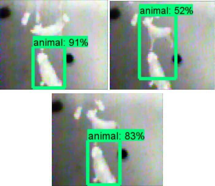
BigkiSining: Creativities and innovations for global environmental sustainability
Presented at the 11th DLSU Arts Congress
De La Salle University, Manila, Philippines
February 7 and 8, 2018

2. RELATED LITERATURE
2.1 Existing Works
   2.1.2 Thermal Imaging Surveillance Cameras
          A company known as Silent Sentinel are known in developing products that are technologically
advanced. They are well experience in producing CCTV cameras and ancillary equipment. They are also famous
in developing Thermal Cameras.
Thermal Imaging Surveillance camera developed by Silent Sentinel are designed to operate without ambient
light or illumination thus, it can provide excellent image quality in any given environment. It can be used as an
independent security device. It also improve security systems. As thermal cameras can detect heat and produce
high contrast images which suites video analytics and motion detection perfectly. Also Thermal Imaging
cameras measure heat and converts it into a visible image which makes it ideal for zero light surveillance, and
will operate in all weather conditions. It can provide clear image in the dark, fog and smoky environment thus
making it best surveillance camera. Radiometric models will give an alarm output, when a parameter is
breached. It covers a large distance. When combined with a video camera as in the Oculus, the best features of
video and thermal are combined to provide the user with a surveillance device to capture any event. Silent
Sentinel have a broad range of Thermal Imaging cameras within their product range from small fixed cameras,
through the Oculus Ti range to the longer range capabilities of the Osiris PTZ positioning system. “Combining
video with thermal imaging in the same device is becoming the most common style of unit we supply,” said
James Longcroft of Silent Sentinel. [9]

  2.1.2 Conservation Drones for Animal Monitoring
         This research focuses on the automatic surveillance of the animal distribution and abundance for the
purpose of nature conservation. The author of this paper makes it a point that the use of drones would serve as
a solution for a fast, efficient, and less expensive method of monitoring animals in their natural habitat. The
objective of this paper is to be able to investigate the combination of drones with automatic detection techniques
that would detect objects for the main purpose of performing manual animal surveying tasks.

Such an objective was met with the use of a quadcopter drone for obtaining and recording datasets for animal
conservation tasks, specifically, animal detection and animal counting. These two types of computer vision tasks
would then be evaluated with the use of three different algorithms consisting of different object detection
methods. The results from the evaluation can be used to conclude that the techniques for detecting object are
promising for nature conservation tasks. [3]

  2.1.3 Computer-Aided Military Drone with Human-Detecting Capability using OpenCV
          This dissertation paper was conducted by students taking up a degree in Electronics and
Communications Engineering. Their aim was to develop a helicopter that can detect human in an upright
position. The purpose of their study is to help the military and rescuers to locate people that are trapped inside
a facility during a search and rescue operation. The students used a normal camera that was attached to the
helicopter where the live feed was viewed in a laptop. They used an analog transmitter and receiver for the
transmission of data and also a GPS in order to distinguish the location of the person. They were able to
successfully assemble the prototype and also develop a code for image processing with the use of OpenCV. After
several tests in the field, their program was able to detect human with a maximum success rate of 56%. [10]

  2.1.4 Project KWAGO: Search and Rescue Drone
Drones are now being used in several applications such as security, disaster management, wildlife conservation.
In the Philippines, disasters such as flood and earthquakes are often occurring. A group of Filipino researchers
developed a search and rescue drone called Project Kwago. The project name came from the Filipino term of
“owl”. Owls have capabilities of hunting especially during night time. The group is composed of Mac Eugenio,
Ari Trofeo, and Vince Villena. The group aims to help boost the search and rescue operations during calamities.
Project Kwago also aims to provide more features in search and rescue drones used in the Philippines.
BigkiSining: Creativities and innovations for global environmental sustainability
Presented at the 11th DLSU Arts Congress
De La Salle University, Manila, Philippines
February 7 and 8, 2018

The drones used locally can only take photo and videos during daytime while Project Kwago can capture photo
and videos even at night. It is also equipped with a thermal camera to detect heat signatures of human. The
project operates by first taking an automated thermal scan on a specific area to detect heat signatures. It will
then relay the detected signatures on the ground. It also contains sonars to avoid obstacles. The researchers also
considered the cost of building this project since drones are known to be expensive. With the use of locally
available materials, they were able to develop Kwago without sacrificing its quality. [11]

2.2 Lacking in the Approaches
                                Table 1.2 Summary of Lacking in the approaches
Conservation Drones for           Animal        Surveillance       Computer-Aided Military Drone with
Animal Monitoring                 Quadcopter Using Thermal         Human-Detecting Capability using
                                  Camera                           OpenCV

Digital Camera                    Thermal Camera                   Digital Camera

Quadrotor                         Quadrotor                        Helicopter

Automatic Control                 Manual Control                   Manual Control

Non-real Time Viewing             Real-time Viewing                Real-time Viewing

The use of thermal cameras are superior over the use of digital cameras since the former is capable
of being used in the night. It is also more efficient than using night vision cameras since it can still
be used to detect organisms in unpleasant conditions. Such conditions pertain to the environment
situations like the presence of fog or smoke. [10]

Comparing the design of the drones, the two types of drone designs that were presented in the
researches include the traditional frames of the quadrotor and the helicopter. The use of quadrotor
drone design is more favored when compared to the helicopter because of its significant difference in
payload. A quadrotor design offers more allowance of being able to carry an external load which is
important due to the requirement of having to equip a camera into the drone. This would also give
an advantage for the user of being able to control the drone with more ease and precision.

Being able to control the drones manually also offers the user real-time viewing unlike when drones
are controlled automatically where users are only able to obtain the informations gathered after the
drone was able to make its round of the vicinity. With this in mind, the users may be able to take
immediate action in situations where the animals are threatened.
BigkiSining: Creativities and innovations for global environmental sustainability
Presented at the 11th DLSU Arts Congress
De La Salle University, Manila, Philippines
February 7 and 8, 2018
3. METHODOLOGY
Figure 3.1 Summary of Methodology
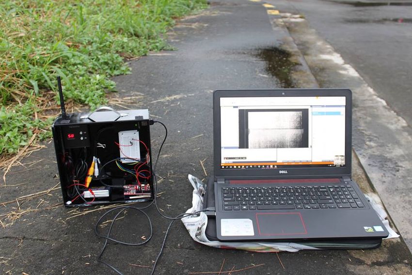
The implementation of the whole prototype started with the assembling of the
quadrotor together with the thermal camera. Components such as the flight controller,
transmitter, GPS, thermal camera and 1 Lipo battery was placed in a box where the
components’ weight were taken into consideration before assigning where it will be placed
inside the box. This box was then attached to the quadcopter. The base station on the other
hand consists of the receiver and the laptop where the feed of the camera is shown through
the help of the device EasyCap. Before anything else, the environment where the code will
be made needs to be setup first through Anaconda Cloud. Through the application
anaconda, the group was able to create an environment only designated for the machine
learning only. The packages needed were installed using the ‘pip’ command of python. The
version of python was set to 3.5 since it is the version where tensorflow can be used.
Figure 3.2 Transmitting side setup
Figure 3.3 Base Station Setup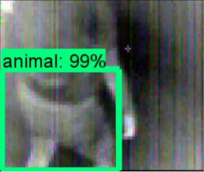
BigkiSining: Creativities and innovations for global environmental sustainability
Presented at the 11th DLSU Arts Congress
De La Salle University, Manila, Philippines
February 7 and 8, 2018

       The next step that was done is gather thermal images of animals that will be used
for the training of the machine. The group gathered pictures during daytime and nighttime
to compare which situation will the animal detection be more accurate. Several files were
generated in order to start the training. The XML files from the annotation tool was
converted to CSV file. The label map code on the other hand contains the classes and at the
same time the label of the object that is aimed to be detected. Once these files are gathered,
the training of the machine was started.. The group was able to research a library that is
mainly used for machine learning which is called Tensorflow. There were several tutorials
and ready-made models available in github.

                                              Figure 3.4 LabelImg

       The detection model that the group chose is Single Shot Multibox Detection made by
mobilenet. This model fulfills the real-time detection since it is categorized as fast detector
model. On the side note, this model is less accurate compared to other models such as
Regional Convolutional Neural Network. The downside of this model is that it will forfeit
the real-time detection objective of the group’s paper.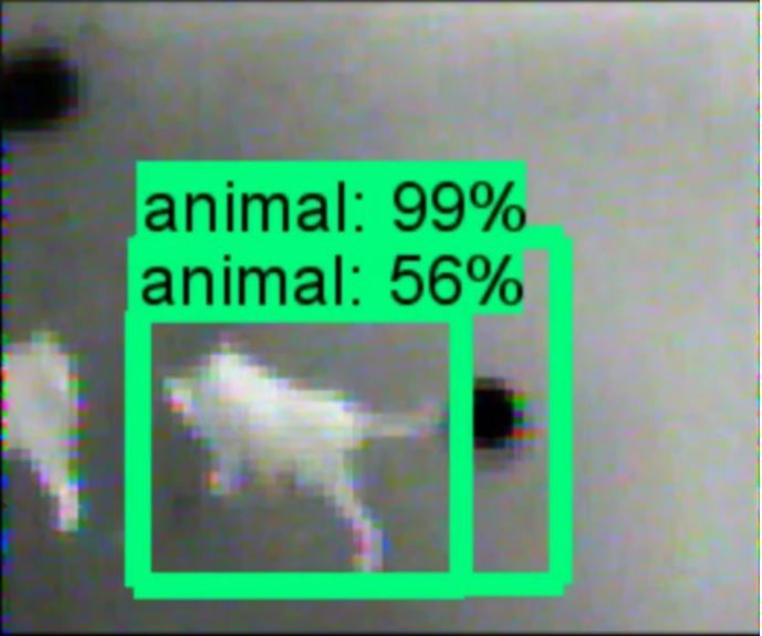
BigkiSining: Creativities and innovations for global environmental sustainability
Presented at the 11th DLSU Arts Congress
De La Salle University, Manila, Philippines
February 7 and 8, 2018

       Before we stopped the training of the machine, the total loss during the training
must be taken into consideration. The total loss must at least reach 1.5 to ensure that the
machine training will yield good results. To further improve the output, the machine can be
stopped when the loss hits a value of 1. On the group’s machine training, when the total
loss average reached a value of 1.3, it was stopped.

      The detection was tested using drone pre-recorded videos of animals using the
thermal camera. For the GSM part of the prototype, the group created a serial
communication between Arduino and the python code where the GSM module will send a
message to the user once an animal is detected.

               Table 3.5 Pseudocode for detection code in python and GSM code in Arduino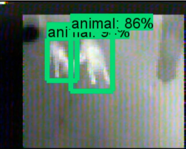
BigkiSining: Creativities and innovations for global environmental sustainability
Presented at the 11th DLSU Arts Congress
De La Salle University, Manila, Philippines
February 7 and 8, 2018

       For the actual gathering of data, the testing took place inside a village and the
maximum number of animals that the group tested with is 3 animals. The testing scenario
can be visualized with the picture below.
*pic actual test

4. RESULTS AND DISCUSSION
For the data gathering, the group used real-time videos in the following scenarios:

              •    Scenario 1 - Stable + daytime + 2 animal
              •    Scenario 2 - Moving + daytime + 1 animal
              •    Scenario 3 - Moving + nighttime + 1 animal
              •    Scenario 4 - Moving + daytime + 3 animals
              •    Scenario 5 - Moving + nighttime + 3 animals

Take note that all scenarios are taken in a village where the group borrowed animals from
the people living in the neighborhood. The animals where we tested the detection are dogs
only since the it is more accessible.

The data that the group took into consideration is the number of errors that occurred in one
video, duration of the error, and type of error. The group considered 4 categories of error:

                                      Animal not detected             Non-animal detected

                                      Multi-box                        Sequential detection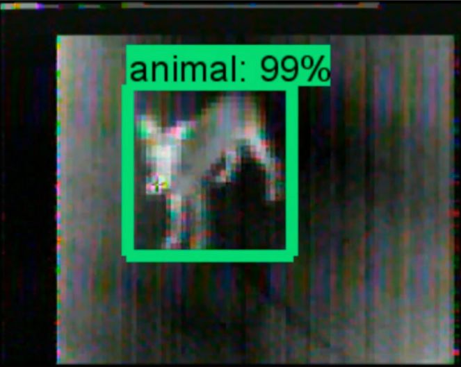
BigkiSining: Creativities and innovations for global environmental sustainability
Presented at the 11th DLSU Arts Congress
De La Salle University, Manila, Philippines
February 7 and 8, 2018

The pictures that are placed below are sample photos of right detection.

       Take note that the duration of each error is an estimate only. The short and long
duration was manually counted based on the video.

                                          Table 4.1 Classification of errors
Duration                                                       Time

Single flicker                                                 1 second

Continuous flickering                                          3 seconds

Short duration                                                 Manually counted

Long duration                                                  Manually counted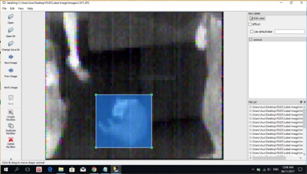
BigkiSining: Creativities and innovations for global environmental sustainability
Presented at the 11th DLSU Arts Congress
De La Salle University, Manila, Philippines
February 7 and 8, 2018

            Table 4.2 Average data for Scenario 1               Table 4.3 Average data for Scenario 2

                           Scenario 1                                           Scenario 2

           Total Duration of Errors 181 seconds                  Total Duration of Errors 52 seconds

             Total Length of Video        685 seconds             Total Length of Video      530 seconds

                  Percent Error               26.42%                   Percent Error           9.81%

               Percent Accuracy               73.58%                 Percent Accuracy          90.19%

          Table 4.4 Average data for Scenario 3               Table 4.5 Average data for Scenario 4

                          Scenario 3                                          Scenario 4

          Total Duration of Errors 165 seconds                 Total Duration of Errors 27 seconds

            Total Length of Video        495 seconds            Total Length of Video      100 seconds

                Percent Error                 33.33%                 Percent Error            27%

              Percent Accuracy                66.67%               Percent Accuracy           73%

          Table 4.6 Average data for Scenario 5               Table 4.7 Average percentage for all scenarios
                          Scenario 5                                 Average Percentage of all Scenarios
          Total Duration of Errors 33 seconds                  Total Duration of Errors        463 seconds
            Total Length of Video         90 seconds           Total Length of Video           1900 seconds

                 Percent Error                36.67%           Percent Error                   24.37%
                                                               Percent Accuracy                75.63%
               Percent Accuracy               63.33%

5. CONCLUSIONS
        The study was able to achieve the objectives that were presented during thesis 1.
The prototype that was made by the group was able to detect animals using thermal
camera. Based on the data that was gathered, the group achieved the 70% accuracy for the
detection system. Using the transmitter and receiver, the computer and the camera were
able to communicate with each other. The GSM module was able to successfully send a text
message to the user alerting the user that an animal was detected. The serial
communication between the Python code and the Arduino was made possible due to the
integration of Pyserial. This allows Python to communicate with the Arduino and send data
to it that an animal was detected. It is easier to test the prototype to a place with high
mobile network coverage.
BigkiSining: Creativities and innovations for global environmental sustainability
Presented at the 11th DLSU Arts Congress
De La Salle University, Manila, Philippines
February 7 and 8, 2018
Objectives are successfully met by the group and by testing the used materials along
with a low spec thermal camera. The group concluded that it was hard for the system to
detect animals during daytime since it will capture heat signature from the heat of the sun.
In addition with the heat of the sun, the heat-conducting materials such as metals and
cement also stores heat which reduces the accuracy of the detection since heat detection
overlaps the surrounding and the animal. Based on the results, the group concluded that
the animal detection is more accurate during nighttime than daytime due to less heat
caused by nature and its surroundings
6. RECOMMENDATIONS
Flying of drones is prohibited in most public places that is why the group was unable
to test the prototype to various animals such as animals not appropriate as pets. The group
was only able to test the prototype to animals that are considered pets like dogs and cats in
private places. To obtain more accurate results, it is recommended to test the prototype on
various animals. Furthermore, it is also recommended to feed more pictures to the machine
to obtain more accurate results.
Since the group used a thermal camera with low resolution, the drone is unable to
fly higher since the camera would not able to capture the subjects below. Thus, the group
recommends a higher resolution camera for better streaming which will cost more but will
surely yield better detection results. With the use of better camera, small animals can also
be detected. If possible, the next researchers may use a camera with color spectrum since
the group only used a thermal camera limited to black and white. The use of thermal
camera with colored spectrum, cold-blooded animals can be included in the future
researches. Since the drone that the group used has a flight time of 13- 15 minutes only,
testing of the prototype is limited to a short period of time. It is recommended to utilize a
quadcopter with better specifications and battery life. This thesis is limited to detecting
animals but unable to determine what kind of animal is detected. The group recommends to
add a feature that determines what kind of animal is detected. To further test the accuracy
of the detection system, future researchers may used a better camera and gather data while
varying the altitude of the drone to see if the system will still be able to detect animal from
a higher altitude. For a better prototype, the group recommends to add a feature of having
a quadcopter that is able to have an automated flight that is directed by the users.
7. ACKNOWLEDGEMENT
First, we would like to thank God for the enlightenment and motivation that allowed
us to accomplish our thesis.
The group would like to thank their parents, Roel and Maria Agnes Siccion, Jose
and Elmadel Figueroa, Ariel and Nerissa Mendoza, Luisito and Zenaida Soliman, for their
financial support and help in acquiring the needed materials for this project. Their endless
guidance and support encouraged us to finish our thesis.BigkiSining: Creativities and innovations for global environmental sustainability
Presented at the 11th DLSU Arts Congress
De La Salle University, Manila, Philippines
February 7 and 8, 2018
To our thesis adviser, Engr. Donabel Abuan, who is always so supportive with our
project, suggested the machine learning part, and for guiding us all throughout the process
of accomplishing our project.
To our panelists, Dr. Argel Bandala, Dr. Jay Robert del Rosario, Engr. Roderick Yap,
for acknowledging the possible errors we might encounter in our project, suggesting
possible solutions to them, and challenging us to make our thesis better.
The training and execution of our detection code would not be possible without the
help of Macky Vergara, Ate Paday, Tita Josie Cruz, Ate She, Tita Sunny Vergara, Mayor
Alvin Vergara, Tita Regina Aparri, Tito Donald Aparri, and Charlie Sheen Aparri. Their
efforts in assisting us while taking photos and videos of their pets is greatly appreciated.
Their guidance and support has contributed a lot to the development of the thesis. We are
grateful for accommodating us into your homes and for allowing us to test our prototype on
your pets.
We would like to extend our gratitude to the dogs, Toni G and her puppies, Stacey,
Apollo, Hachiko, Chestnut, Cali, Gio, Athena, Hercules, Percy, Gab, Cibo, Chica, Brownie,
who participated in our training and testing. Without these dogs, our thesis would not be
accomplished.
We would also like to thank the Soliman family for accommodating us into your
home that provided us a nice environment to create our thesis project. Their subdivision
allowed us to test the quadrotor, and execute our finished prototype as well.
We would like to thank our friends, Joshua Rillo and Joseph Samuel Sazon, for
helping us with our software and hardware for this thesis.
Above all, to the Great Almighty, the author of knowledge and wisdom, for his
countless love.
To God be the glory.
8. REFERENCES
[1] G. Yarrow, “Wildlife and wildlife management,” 2009.
[2] C. R. Verschoor, “Conservation drones for animal monitoring,” Master’s thesis, 2016.
[3] R. N. Handcock, D. L. Swain, G. J. Bishop-Hurley, K. P. Patison, T. Wark, P. Valencia, P. Corke,
, and C. J. O’Neill, “Monitoring animal behavior and environmental interactions using wireless
sensor networks, gps collars and satellite remote sensing,” 2009.
[4] C. Press, “Using drones without disturbing wildlife,” 2016.
[5] S. S. Company, “Thermal surveillance cameras,” 2016.
[6] A. L. Delloro, R. P. Gochangco, J. E. Limqueco, and G. E. Urbino, “Computer-aided military
drone with human-detecting capability using opencv,” 2001.
[7] T. S. Express, “Filipino-made drone can help boost search and rescue operations.,” 2016.
[8] “Anaconda: The most popular python data science platform,” 2017.
[9] “What is python? executive summary.”
[10] “Microsoft visual studio.”
[11] P. Dwivedi, “Building a toy detector with tensorflow object detection api,” 2017.
[12] “Mobilenet.”
[13] “Ssd: Single shot multibox detector.”You can also read