Annex 4 - Sensitive Areas and coastal information - Bay of Plenty ...
←
→
Page content transcription
If your browser does not render page correctly, please read the page content below
BOPRC OSCP
                                                                                                Annex 4
                                                                 Sensitive areas and coastal information

Annex 4 – Sensitive Areas and coastal information
Sensitive Areas classification                                                                 1

Oil Spill risk                                                                                 1
Overview of spill risk                                                                         1
Risk sites                                                                                     1
Harbour limits                                                                                 2
Tauranga Port pipelines                                                                      10
Sulphur Point Container Terminal Spill                                                       18
Storm water plans and terrestrial oil spill response                                         21
Shipping routes                                                                              21
Places of refuge                                                                             21

Wildlife response information specific to the Bay of Plenty region 22
Bay of Plenty wildlife likely to be threatened by an oil spill                               22
Priority areas for protection                                                                30

Tauranga Harbour                                                                             30

Site Maps                                                                                    33
Index                                                                                        33
   Port of Tauranga – Mt Maunganui                                                            37
   Waiau/Athenree                                                                             39
   Upper Tuapiro Estuary                                                                      42
   Tuapiro Estuary Spit                                                                       44
   Uretara Upper                                                                              46
   Uretara East                                                                               47
   Waikoura Point                                                                             48
   Rereatukahia                                                                               50
   Puketutu Point                                                                             52
   Matakana North                                                                             54
   Site 11                                                                                    56
   Maheka Point                                                                               56
   Risk ranking: 2                                                                            56
   Matakana South                                                                             58
   Aongatete                                                                                  60
   Wainui                                                                                     62
   Central Mangroves                                                                          64
   Te Hopai Island                                                                            66
   Apata Estuary                                                                              68
   Blue Gum Bay                                                                               69
   Pahoia North                                                                               71
   Pahoia South                                                                               72
   Site 21                                                                                    73
   Tahunamanu Spit/Island                                                                     73
   Risk ranking: 1                                                                            73

27 March 2018
Bay of Plenty Marine Oil Spill Contingency Plan                                                 i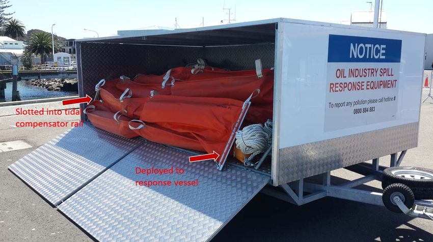
BOPRC OSCP
                                                                                           Annex 4
                                                            Sensitive areas and coastal information

     Hunter Creek                                                                        75
     Opureora Spit                                                                       77
     Motungaio Island                                                                    79
     Te Puna                                                                             81
     Rangiwaea East                                                                      83
     Rangiwaea West Estuary                                                              85
     Panepane Pt                                                                         87
     Wairoa River                                                                        89
     Matua                                                                               91
     Mauao - Mount Maunganui                                                             93
     Moturiki (Leisure) Island                                                           95
     Motuotau (Rabbit) Island                                                            97
     Waikareao Estuary                                                                   99
     Waimapu –Yatton Park                                                               101
     Waimapu –Windermere                                                                102
     Waipu Bay/Tauranga Airport                                                         104
     Rangataua Bay North                                                                106
     Welcome Bay                                                                        108
     Rangataua Bay South                                                                109
     Motiti Island                                                                      110
     Taumaihi Island (‘The Knoll’)                                                      112
     Maketu Estuary, beach and spit                                                     114
     Okurei Point                                                                       116
     Little Waihi Estuary                                                               118
     Waitahanui Stream                                                                  120
     Hauone Stream                                                                      122
     Pikowai Stream                                                                     124
     Herepuru Stream                                                                    126
     Matata Lagoon                                                                      128
     Rangitaiki River East                                                              130
     Whakatane River/Estuary                                                            132
     Kohi Point                                                                         134
     Ohiwa Harbour/Estuary                                                              136

Ōpōtiki to East Cape                                                                    138
     Waiotahi Estuary                                                                   138
     Waioeka Estuary                                                                    140
     Waiaua Estuary                                                                     142
     Waiiti River and Torere                                                            144
     Motu River                                                                         146
     Haparapara                                                                         148
     Kereru River Mouth                                                                 150
     Raukokore River                                                                    152
     Orete Point                                                                        154
     Oruatiti and Waikanapanapa                                                         155
     Whangaparaoa River                                                                 156
     Otarawhata Island                                                                  158
     Whakaari (White Island)/ Volkner Rocks                                             159
     Karewa Island                                                                      166
     Tuhua (Mayor Island)                                                               168
     Moutoki Island                                                                     170
     Rurima Island                                                                      172
     Motunau (Plate) Island                                                             174
     Moutuhora (Whale) Island                                                           176
     Motuhaku (Schooner Rocks)                                                          178

                                                                               27 March 2018
ii                                            Bay of Plenty Marine Oil Spill Contingency Plan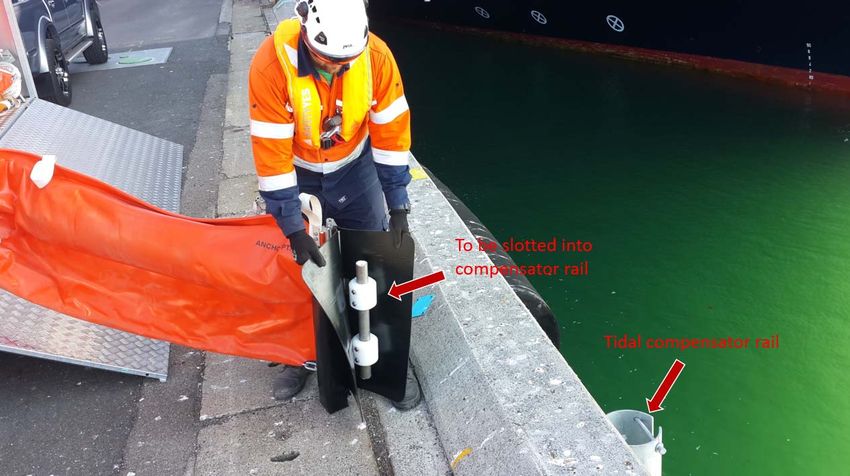
BOPRC OSCP
                                                                                                         Annex 4
                                                                          Sensitive areas and coastal information

Sensitive Areas classification
The sensitive sites identified in this plan are identified for their environmental, cultural or economic
significance for the region and the potential effects of an oil spill on these sites.

Oil Spill risk
Overview of spill risk
Historical records show that most significant spills that occur in the Bay of Plenty region, occur in
Tauranga Harbour during bunkering of ships, tank loading/discharge operations or the internal transfer of oil
within a ship.

Spills that occur in other harbours or the coastal area of the region are generally very small, are of a non-
persistent oil nature (petrol, diesels) and occur during pleasure/fishing boat refuelling operations. However,
international shipping casualties in recent years illustrate the potential for a large spill.

Risk sites
The following oil transfer sites, types of oil, and orders of magnitude are considered to be representative of
the risk within the Bay of Plenty region.

          Table 1           Tier 1 Transfer Sites in Bay of Plenty

                                                                         Strike through = Site blocked off
                                                                                   Expected order of
    Location                                  Transfer type     Oil type
                                                                                   magnitude
    Mount Maunganui Wharf: 15 m               Bunkering         Heavy fuel oil      3 tonnes
    Mount Maunganui Wharf: 170 m              Bunkering         Heavy fuel oil      3 tonnes
    Mount Maunganui Wharf: 355 m              Bunkering         Heavy fuel oil      3 tonnes
    Mount Maunganui Wharf: 525 m              Bunkering         Heavy fuel oil      3 tonnes
    Mount Maunganui Wharf: 1243 m             Bunkering         Heavy fuel oil      3 tonnes
    Mount Maunganui Wharf: 1488 m             Bunkering         Heavy fuel oil      3 tonnes
    Mount Maunganui Wharf: 2056 m             Bunkering         Heavy fuel oil      3 tonnes
    Tanker berth                              Bulk Transfer     Petrol-bitumen      15 tonnes
    Tug berth                                 Bunkering         Diesel              250 litres
    Sulphur Point                             Slops Transfer    Admixtures          500 litres
    Bridge Marina refuelling jetty            Bunkering         Diesel/petrol       180-200 litres/min
    Ice plant between Cross Road boat
                                              Bunkering         Diesel              180-200 litres/min
    ramp and slipway
    Tauranga Marina refuelling jetty          Bunkering         Diesel/petrol       180-200 litres/min
    Sanfords                                  Bunkering         Diesel/Lube Oil     180-200 litres/min
    Lake Rotorua                              Bunkering         Diesel              180-200 litres/min
    Port Whakatane                            Bunkering         Diesel/petrol       180-200 litres/min
    Port Ohope Wharf                          Bunkering         Diesel              180-200 litres/min

27 March 2018
Bay of Plenty Marine Oil Spill Contingency Plan                                                          1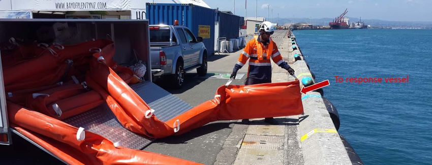
BOPRC OSCP
Annex 4
Sensitive areas and coastal information
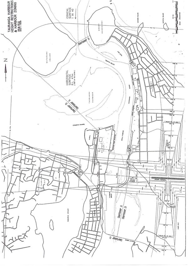
Harbour limits
27 March 2018
2 Bay of Plenty Marine Oil Spill Contingency Plan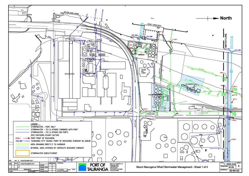
BOPRC OSCP
                                                                                                         Annex 4
                                                                          Sensitive areas and coastal information

For an up to date Port/Industry Booming Plan see:

Objective folder ID fA959926 entitled 2017-11-24 Final Approved Industry Plan: (This text is not a link to the
document – please open from Objective at the above reference).

27 March 2018
Bay of Plenty Marine Oil Spill Contingency Plan                                                                3
BOPRC OSCP
                                                 Annex 4
                  Sensitive areas and coastal information

                                     27 March 2018
4   Bay of Plenty Marine Oil Spill Contingency Plan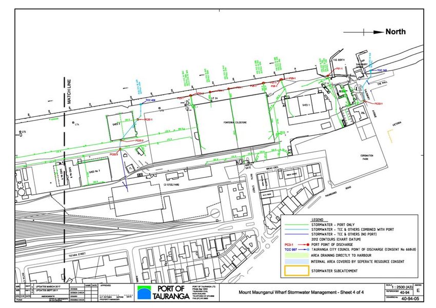
BOPRC OSCP
                                                                                 Annex 4
                                                  Sensitive areas and coastal information

27 March 2018
Bay of Plenty Marine Oil Spill Contingency Plan                                        5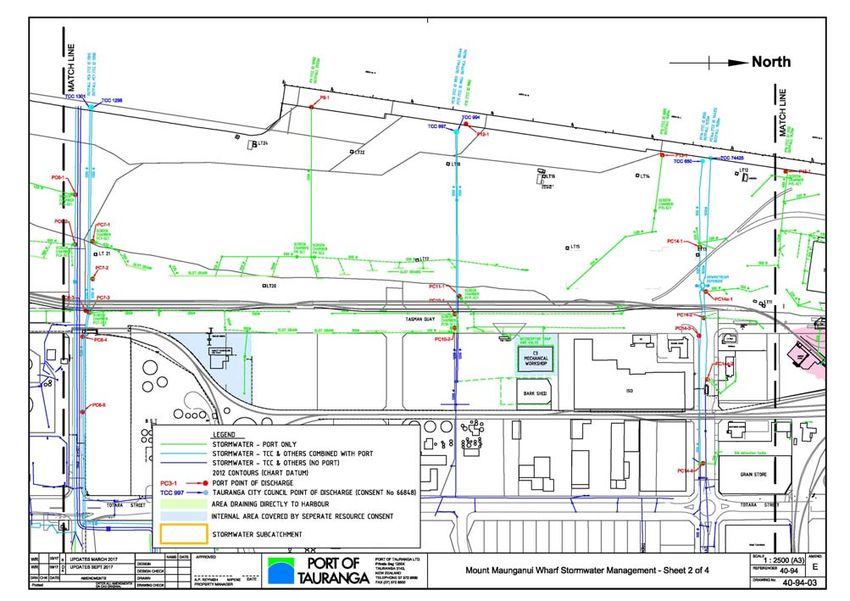
BOPRC OSCP
                                                 Annex 4
                  Sensitive areas and coastal information

                                     27 March 2018
6   Bay of Plenty Marine Oil Spill Contingency Plan
BOPRC OSCP
                                                                                 Annex 4
                                                  Sensitive areas and coastal information

27 March 2018
Bay of Plenty Marine Oil Spill Contingency Plan                                        7
BOPRC OSCP
                                                 Annex 4
                  Sensitive areas and coastal information

                                     27 March 2018
8   Bay of Plenty Marine Oil Spill Contingency Plan
BOPRC OSCP
Annex 4
Sensitive areas and coastal information
Staff entering the Port of Tauranga must first complete a Port Health and Safety Induction which can be
found at:
https://www.port-tauranga.co.nz/health-safety/port-inductions/
(This text is not a link to the document).
All staff must observe Port Health and Safety procedures at all times. This includes carrying photo
identification and evidence of completion of the induction, observing speed limits and access rules as well as
the wearing of the proscribed Personal Protection Equipment (PPE) at all times.
27 March 2018
Bay of Plenty Marine Oil Spill Contingency Plan 9BOPRC OSCP
Annex 4
Sensitive areas and coastal information
Tauranga Port pipelines
27 March 2018
10 Bay of Plenty Marine Oil Spill Contingency PlanBOPRC OSCP
Annex 4
Sensitive areas and coastal information
First Containment Response for specific situations
Tanker Berth - Heavy Bunker Fuel Oil
Pipeline or hose leak during transfer
Minimal spillage - Containment by Oil Sorbent Boom
(as per Diagram 1)
If safe to do
Complete the Initial Response Checklist.
Place sorbent pads/boom or zeolite in area where leak is flowing into water to curb flow.
Throw soak up pads onto product on water if they can be contained and recovered.
If any product tracks to drains or outside bunded area, contain with sorbent fill/sand.
Lay more booms if Port/Contractor/Regional Council vessel arrives.
Apply pipeline clamps if possible.
Use sandbags to stop any flow to other areas or keep product off rocks etc.
If spill escapes containment area, review location of sensitive areas. Determine which of these may be
threatened and direct response personnel to proceed with boom to divert any remaining spill.
Evaluate tide direction and time of tide change to determine best location to contain oil.
Place sorbent boom down current of spill but prepare for tide change and moving location
of spill equipment.
North end of tanker berth
1 Open the Boom Storage lid and the side blue doors. Take out the 20 m berth end rope and take to the
berth pulley end.
2 Tie one end of the boom to the mooring line and place rubber mat on rocks as a guiding platform for the
boom.
3 Once the boom is tied, begin to pull the pulley rope and let the boom coil out as the pulley is being
utilised. The boom may need to be guided into the water.
4 Once the boom reaches the wharf end pulley, grab hold of the boom and tie the 20 m rope at the end of
it and the other end of the rope to the walkway railings.
5 Untie the boom from the pulley and chuck it in the water so that it does not get caught/stuck to any pipes
or pillars. Use the rope to manoeuvre the boom into place. Re-adjust rope on the walkway. The boom
should be fully displaced on water.
6 Adjust position of boom using the ropes tied at the end as required.
7 When response vessel arrives and in position (close to the boom) untie the rope from the walkway and
drop it in the water.
8 Vessel crew to gather the rope and tie it to the wharf edge ensuring no gap between boom and wharf
edge.
27 March 2018
Bay of Plenty Marine Oil Spill Contingency Plan 11BOPRC OSCP
Annex 4
Sensitive areas and coastal information
South end of tanker berth
1 Open the Boom Storage lid and the side blue doors. Take out the 20 m berth end rope and pass on to
the response vessel.
2 Tie one end of the boom to the response vessel.
3 Once the boom is tied, begin to slowly steer the vessel to the tie off point.
4 The boom may need to be guided into the water as the vessel draws it out, to ensure the storage
container does not tip over and the boom getting caught on sharp edges.
5 Shore crew to communicate to the vessel to stop before the entire length of the boom is drawn out so
that the end of the boom can be tied to the pulley stand.
6 Response vessel ties boom to wharf edge.
27 March 2018
12 Bay of Plenty Marine Oil Spill Contingency PlanBOPRC OSCP
Annex 4
Sensitive areas and coastal information
DIAGRAM 1 Oil Spill Boom Plan – Tanker Berth
Sorbent
Sorbent or Booms tied off
Floating Booms
may be tied off
from Shore to
from shore to Dolphins or
around bow or Front Edge of
stern of ship
Berth.
This is to try
and contain
product at
shore edge
27 March 2018
Bay of Plenty Marine Oil Spill Contingency Plan 13BOPRC OSCP
Annex 4
Sensitive areas and coastal information
First Containment Response for specific situations
Main wharf (Berth 1 to 11) - Heavy fuel oil
Pipeline or hose leak during bunker transfer
If safe to do
Complete the Initial Response Checklist.
Ensure no ignition sources in area.
Place sorbent pads or boom or kitty litter in area where leak is flowing into water to curb flow.
Throw soak up pads onto product on water if they can be contained and recovered.
Place sorbent boom and/or floating boom down tide of spill.
Tie off at first available point past any berthed vessels.
If able, tie up under wharf with access from pipeline lateral walkways.
If not possible, tie off at Pilot boat area north end of wharf.
If not possible, tie off at Berth 11 South end past all vessels berthed.
Lay boom out to front edge of wharf.
Take rope from boom and take onto ship and lay boom around bow or stern of ship.
If possible, arrange for boat crew to take boom and lay at bow/stern of boat.
Lay out more than one if possible.
If any product tracks to drains or outside bunded area, contain with sorbent fill/sand.
Lay more booms if Port/Contractor/Regional Council vessel arrives.
Advise boats operating in area of potential danger and direct them away from area.
Apply pipeline clamps if possible.
Use sump truck to recover any product.
If spill escapes containment area, review location of sensitive areas. Determine which of these may be
threatened and direct response personnel to proceed with boom to divert any remaining spill.
27 March 2018
14 Bay of Plenty Marine Oil Spill Contingency PlanBOPRC OSCP
Annex 4
Sensitive areas and coastal information
First Containment Response for specific situations
Tanker berth and main wharf - heavy fuel oil
Pipeline or hose leak during transfer
Phase 2 - Containment by fixed floating boom
(as per Diagram 2 and 3 and accompanying photos)
Evaluate tide direction and time of tide change to determine best location to contain oil.
Place floating boom down current of spill but prepare for tide change and moving location
of spill equipment.
North end – Berth 1
Move spill trailer into position.
Unlock and open trailer doors.
Take Tidal Compensator slider (fixed to boom) out and place into fixed Tidal Compensator.
Take out anchor and float and hand to recovery vessel.
Hand radio to vessel to enable good communication.
Take out blank end of boom from trailer and throw into water close to recovery vessel.
Recovery vessel to recover boom and attach anchor and float to seaward end.
Vessel will tow boom out to harbour.
Ensure all personnel stand out of way when assisting boom to move.
All personnel to have Personnel Flotation Devices.
Recovery vessel drops 13 kg Danforth sand anchor when positioned.
Anchors will be attached to minimum 10 m of chain.
Chain to be attached to minimum 65 m of anchor rope.
If tide is running fast may need to lessen angle of boom.
Extra booms available from BOPRC.
Assist in laying more booms if Port/Contractor/Regional Council vessel arrives.
South end – Butters Landing
Unlock and open spill container doors.
Take Tidal Compensator slider (fixed to boom) out and place into fixed tidal compensator.
Take out anchor and float and hand to recovery vessel.
Hand radio to vessel to enable good communication.
Take out blank end of boom from trailer and throw into water close to recovery vessel.
Recovery vessel to recover boom and attach anchor and float to seaward end.
Vessel will tow boom out to harbour.
Ensure all personnel stand out of way when assisting boom to move.
All personnel to have Personnel Flotation Devices.
Recovery vessel drops 13 kg Danforth sand anchor when positioned.
27 March 2018
Bay of Plenty Marine Oil Spill Contingency Plan 15BOPRC OSCP
Annex 4
Sensitive areas and coastal information
Anchors will be attached to minimum 10 m of chain.
Chain to be attached to minimum 65 m of anchor rope.
If tide is running fast, may need to lessen angle of boom.
Extra booms available from BOPRC.
Assist in laying more booms if Port/Contractor/Regional Council vessel arrives.
If BOPRC supplies more boom, once fixed to shore, these may be taken out into the harbour or they can be
taken around the bow or stern of the tanker to contain any product.
27 March 2018
16 Bay of Plenty Marine Oil Spill Contingency PlanBOPRC OSCP
Annex 4
Sensitive areas and coastal information
Diagram 2
Main Berth Oil Spill Plan
Berth 1 with Self Floating Boom
Tide Run
75 metre Self Floating Boom
(from spill equipment trailer) off
North End of Wharf (Berth 1) by
Recovery Vessel for outgoing tide.
27 March 2018
Bay of Plenty Marine Oil Spill Contingency Plan 17BOPRC OSCP
Annex 4
Sensitive areas and coastal information
Trailer positioning
Spill Trailer opened and ready for response
27 March 2018
18 Bay of Plenty Marine Oil Spill Contingency PlanBOPRC OSCP
Annex 4
Sensitive areas and coastal information
Tidal Compensator to be connected to compensator rail
Remove bolt on Tidal Compensator
Two man task to fit slider into rail
Boom deployment to Response Vessel
27 March 2018
Bay of Plenty Marine Oil Spill Contingency Plan 19BOPRC OSCP
Annex 4
Sensitive areas and coastal information
Diagram 3 – Tanker Berth and terminal layout
Butters Landing - Spill Equipment Container opened showing booms and equipment ready
to be deployed
27 March 2018
20 Bay of Plenty Marine Oil Spill Contingency PlanBOPRC OSCP
Annex 4
Sensitive areas and coastal information
Sulphur Point container terminal spill
Bay Marine Works provides a rapid response capability to contain oil for Waste Management under the site’s
Tier 1 Plan. For the latest version of the plan see:
Objective Link: zA200611
Waste Management FINAL Approved Tier 1 Plan and signoffs
(This text is not a link to the document – please open from Objective at the above reference).
Storm water plans and terrestrial oil spill response
Either call the Pollution Hotline (0800 884 883) or contact the relevant local council for up-to-date storm-
water plans and shore-side spill response, in relation to discharges occurring from stormwater outlets. Fixed
oil transfer sites are required to provide storm water site layout plans as part of Tier 1 Plan requirements.
Shipping routes
Maritime New Zealand has initiated a voluntary navigation guideline, recommending that ships stay at least
five (5) nautical miles away from any coastline. This guideline is targeted towards vessels laden with oil or
other harmful liquid substances in bulk. Ships pose a risk of oil spill with low probability of occurrence but
high potential effects on the environment.
Places of refuge
Because of the nature of the coastline and the sensitive nature of the environment, there are no designated
Places of Refuge in the Bay of Plenty region.
27 March 2018
Bay of Plenty Marine Oil Spill Contingency Plan 21BOPRC OSCP
Annex 4
Sensitive areas and coastal information
Wildlife response information specific to the Bay of Plenty region
Bay of Plenty wildlife likely to be threatened by an oil spill
Priority Species common Regional NZ threat IUCN Status Breeds Breeding Seasonal
category name priority classification category code in BOP season distribution
code
Aug-Feb
Nationally
1A Grey Duck C LC N y Peaking Oct- Year round
critical
Nov
Nationally
1A White Heron A Not listed N n n/a Sp ,A, W
critical
Nationally
1A Black Stilt A CR E n n/a Year round
critical
Nationally
1A NZ Fairy Tern A LC E n n/a A, W, Sp
critical
Nationally
1B Australasian Bittern B EN N y Jul-Feb Year round
endangered
Nationally
1B Black-fronted Tern C EN E n n/a A, W
endangered
Nationally
1B Black Billed Gull E EN E y Sep-Feb Year round
endangered
Nationally
1C Wrybill C VU E n n/a Sp, A, W
vulnerable
Northern New Nationally
1C B EN E y Aug-Feb Year round
Zealand Dotterel vulnerable
27 March 2018
22 Bay of Plenty Marine Oil Spill Contingency PlanBOPRC OSCP
Annex 4
Sensitive areas and coastal information
Priority Species common Regional NZ threat IUCN Status Breeds Breeding Seasonal
category name priority classification category code in BOP season distribution
code
Nationally
1C Banded Dotterel D Not listed E y Jul-Feb Year round
vulnerable
Nationally
1C Reef Heron B LC N y Sep-Feb Year round
vulnerable
Nationally
1C Caspian Tern B LC N y Sep-Feb Year round
vulnerable
Nationally
1C Red Billed Gull E LC E y Oct-Feb Year round
vulnerable
Nationally
1C Pied Shag C LC N y Aug/Feb Year round
vulnerable
Nationally
1C NZ Dabchick B VU E y Sep - Mar Year round
vulnerable
Nationally
1C Black Petrel B VU E n n/a Year round
vulnerable
2A NZ Pipit C Declining LC E y Aug-Feb Year round
2A Little Blue Penguin A Declining LC N y Jul -Feb Year round
NZ Pied
2A B Declining LC E y Sep - Feb Year round
Oystercatcher
2A Sooty Shearwater C Declining NT N y? Nov-May Year round
2A Pied Stilt B Declining LC N y Jul-Jan Year round
Flesh-footed
2A B Declining LC N y Nov-May Year round
Shearwater
2A White Fronted Tern B Declining LC N y Aug-Feb Year round
27 March 2018
Bay of Plenty Marine Oil Spill Contingency Plan 23BOPRC OSCP
Annex 4
Sensitive areas and coastal information
Priority Species common Regional NZ threat IUCN Status Breeds Breeding Seasonal
category name priority classification category code in BOP season distribution
code
Variable
2B A Recovering LC E y Sep-Feb Year round
Oystercatcher
2B Brown Teal A Recovering EN E y Jun-Feb Year round
Red Crowned
2C B Relict VU E y Aug-Mar Year round
Parakeet
2C Fairy Prion B Relict LC E n Nov-Feb Year round
2C Broad Billed Prion B Relict LC E y Aug-Jan Year round
Common Diving
2C B Relict LC N y Aug-Dec Year round
Petrel
2C Marsh Crake A Relict LC N y Sep-Feb Year round
2C Spotless Crake A Relict LC N y Sep-Feb Year round
2C Cook's Petrel B Relict EN N y Oct-May Year round
Fluttering
2C B Relict LC E y Sep-Feb Year round
Shearwater
Naturally
2D Royal Spoonbill LC N n n/a Year round
uncommon
Naturally
2D Black Shag LC N y Apr-Jan Year round
uncommon
Naturally
2D Little Shag LC E y Aug-Feb year round
uncommon
Naturally
2D Little Black Shag LC N n n/a Year round
uncommon
27 March 2018
24 Bay of Plenty Marine Oil Spill Contingency PlanBOPRC OSCP
Annex 4
Sensitive areas and coastal information
Priority Species common Regional NZ threat IUCN Status Breeds Breeding Seasonal
category name priority classification category code in BOP season distribution
code
Naturally
2D Wandering Albatross VU E n n/a Year round
uncommon
Naturally
2D Royal Albatross VU E n n/a Year round
uncommon
Naturally
2D Banded Rail LC N y Sep-Mar Year round
uncommon
Naturally
2D Giant Petrel LC N n n/a Year round
uncommon
Naturally
2D Buller's Shearwater VU E n n/a Year round
uncommon
Naturally
2D Bullers Mollymawk NT E n n/a Year round
uncommon
Not
3 NZ Shoveler LC E y Oct-Feb Year round
threatened
Not
3 NZ Scaup LC E y Oct-Apr Year round
threatened
Not
3 Grey Faced Petrel LC E y Jun-Jan Year round
threatened
Not
3 Spotted Shag LC E n n/a W
threatened
Not
3 Paradise Shelduck LC E y Aug-Jan Year round
threatened
Australasian Little
4 Coloniser LC N y Dec-Apr Year round
Grebe
27 March 2018
Bay of Plenty Marine Oil Spill Contingency Plan 25BOPRC OSCP
Annex 4
Sensitive areas and coastal information
Priority Species common Regional NZ threat IUCN Status Breeds Breeding Seasonal
category name priority classification category code in BOP season distribution
code
4 Turnstone Migrant LC M n n/a Sp, S, A
4 Cattle Egret Migrant LC M n n/a Sp
Sharp-tailed
4 Migrant LC M n n/a Sp, S, A
Sandpiper
Lesser Knot (red
4 Migrant LC M n n/a Sp, S, A
knot)
4 Red-necked Stint Migrant LC M n n/a Sp, S, A
Black Fronted
4 Coloniser LC N n n/a Sp, S, A
Dotterel
4 Mongolian Dotterel A Vagrant LC S n n/a S
4 Cape Pigeon Migrant Not listed E n n/a Year round
4 Australian Coot Coloniser Not listed N y Aug-Mar Year round
Eastern Bar-tailed
4 Migrant LC M n n/a Year round
Godwit
4 Far Eastern Curlew Migrant LC M n n/a Sp, S, A
Whimbrel -
4 Migrant/Vagrant LC M n n/a Sp, S, A
Asiatic/American
Pacific Golden
4 Migrant LC M n n/a Sp, S, A
Plover
4 Skua Migrant LC M n n/a S
4 Eastern Little Tern Migrant LC M n n/a S
27 March 2018
26 Bay of Plenty Marine Oil Spill Contingency PlanBOPRC OSCP
Annex 4
Sensitive areas and coastal information
Priority Species common Regional NZ threat IUCN Status Breeds Breeding Seasonal
category name priority classification category code in BOP season distribution
code
Black-browed
4 Coloniser EN E n n/a Year round
mollymawk
4 Siberian Tattler A Vagrant LC S n n/a S
5 NZ kingfisher Not threatened Not listed N y Aug-Feb Year round
5 Grey Teal Not threatened LC N y Sept-Jan Year round
5 White Faced Heron Not threatened LC N y Aug-Jan Year round
5 Australasian hawk Not threatened LC N y Sep-Mar Year round
5 Black Swan Not threatened LC I y Year round Year round
Southern Black-
5 Not threatened LC N y Oct-Feb Year round
backed Gull
5 Australasian Gannet Not threatened LC N y Jul-Dec Year round
5 Pukeko Not threatened LC N y Year round Year round
5 Spur Winged Plover Not threatened LC N y June-Jan Year round
Introduced and
6 Rock Pigeon LC I y Sep-Jan Year round
naturalised
Introduced and
6 Mallard LC I y Aug-Feb Year round
naturalised
Introduced and
6 Feral Goose LC I y Sep-Jan Year round
naturalised
Introduced and
6 Canada Goose LC I y Sep-Jan Year round
naturalised
27 March 2018
Bay of Plenty Marine Oil Spill Contingency Plan 27BOPRC OSCP
Annex 4
Sensitive areas and coastal information
Priority Species common Regional NZ threat IUCN Status Breeds Breeding Seasonal
category name priority classification category code in BOP season distribution
code
Introduced
6 Mute swan and LC I n n/a Year round
naturalised
Introduced
6 Blackbird and LC I y Jul-Mar Year round
naturalised
Introduced
6 Yellowhammer and LC I y Jul-Mar Year round
naturalised
Introduced
6 Chaffinch and LC I y Jul-Mar Year round
naturalised
- Muscovy Duck Not listed LC I y Sep-Mar Year round
Key
Status Code:
E Endemic Breeds only in New Zealand territories
N Native Breeds in New Zealand territories and elsewhere
M Migrant A reasonable number migrate to New Zealand territories but do not breed
S Straggler/vagrant Not a regular migrant or few migrate to New Zealand territories but do not breed
I Introduced Introduced by humans
IUCN Classification scheme (http://www.iucnredlist.org) Seasons
CR Critically Endangered Sp Spring
EN Endangered S Summer
VU Vulnerable A Autumn
NT Near Threatened W Winter
LC Least Concern
27 March 2018
28 Bay of Plenty Marine Oil Spill Contingency PlanBOPRC OSCP
Annex 4
Sensitive areas and coastal information
Priority Category
Category 1: First priority for deterrence, rescue and/or rehabilitation
Species with a New Zealand Threat Classification of ‘Threatened’ and/or IUCN Red-list classification (www.iucnredlist.org) of critically endangered (CR), endangered (EN) or
vulnerable (VU). These are ranked from 1A to 1c for further prioritization using the New Zealand Threat Classification system.
1A Nationally critical
1B Nationally endangered
1C Nationally vulnerable
Category 2: Second priority for deterrence, rescue and rehabilitation
Species with a New Zealand Threat Classification of ‘At Risk’ and/or IUCN Red-list classification (www.iucnredlist.org) of critically endangered (CR), endangered (EN) or vulnerable
(VU). These are ranked from 2A to 2D for further prioritisation using the New Zealand Threat Classification system.
2A Declining
2B Recovering
2C Relict
2D Naturally uncommon
Category 3: Third priority for deterrence, rescue and rehabilitation
Species which are endemic to New Zealand and are considered to be ‘Not Threatened’ under the NZ Threat Classification System, and with an IUCN Red-list classification of lower
risk (LR) or not listed.
Category 4: Fourth priority for deterrence, rescue and rehabilitation
Species considered as migrants, vagrants or colonizers under the NZ Threat Classification System, and with an IUCN Red-list classification of lower risk (LR) or not listed.
Category 5: Fifth priority for deterrence, rescue and rehabilitation
Species which are native to New Zealand and are considered to be ‘Not Threatened’ under the NZ Threat Classification System, and with an IUCN Red-list classification of lower risk
(LR) or not listed.
Category 6: Sixth priority for deterrence, rescue and rehabilitation
Species considered to be ‘Introduced and Naturalised’ under the NZ Threat Classification System, and with an IUCN Red-list classification of lower risk (LR) or not listed.
27 March 2018
Bay of Plenty Marine Oil Spill Contingency Plan 29BOPRC OSCP
Annex 4
Sensitive areas and coastal information
Priority areas for protection
This section contains site sheets and maps that show the priority areas for protection inside the
Tauranga Harbour and within the remainder of the Coastal Marine Area. Also included is a description of the
areas, information on access, possible response options and restrictions on options.
Tauranga Harbour
Tauranga Harbour is a large tidal estuary covering an area of 218 km2. The name 'Tauranga' means 'landing
place.'
The surrounding land from which water runs into the harbour is used extensively for urban, horticultural and
agricultural purposes. At the eastern end of the harbour are the landmark Mauao or Mount Maunganui and
the city of Tauranga. This entrance is deeper and allows for a large amount of cargo ships to enter and leave
the Port of Tauranga. At the western end is the small coastal settlement of Otawhiwhi or Bowentown. This
entrance is shallower but is often used by recreational boaties.
Largely covered by pine plantations, Matakana Island forms a natural barrier between the harbour and the
Pacific Ocean. Matakana Island is also home to a number of people who live in the island's settlement. The
island is largely covered in plantation pines for forestry. Many beaches are littered with fallen logs and debris
which could become oiled in event of a spill landing on the shoreline. Consider beach pre-cleans to reduce
secondary contamination of shoreline debris. The sheltered side of the island has inlets and lagoons and the
ocean side of the island is popular with local surfers.
The harbour waters are mostly shallow. At low tide more than 60% of the harbour bed is exposed. The
estuaries of Tauranga Harbour are home to many kinds of wildlife. Young fish spawn in the shallow waters
and many birds nest on the harbour margins. A large volume of water enters and leaves the harbour with
each tide.
The harbour has long been an important resource for the people of the Bay of Plenty. For Maori, the harbour
has strong spiritual significance and is a traditional source of food. Flounder, kahawai, mussels and cockles
are some of the kaimoana (seafood) that can be collected from the harbour. There are often limits as to how
much can be collected and where they can be collected from.
Economic activity revolves around the Port of Tauranga which operates several kilometres of wharves on
land which has been reclaimed from the harbour at Sulphur Point and at Mount Maunganui. Established in
1873, the port handles more export cargo than any other port in the country. The port also transfers large
volumes of a wide variety of oils including persistent oils and waste oil slops.
27 March 2018
30 Bay of Plenty Marine Oil Spill Contingency PlanBOPRC OSCP
Annex 4
Sensitive areas and coastal information
Map Index
27 March 2018
Bay of Plenty Marine Oil Spill Contingency Plan 31BOPRC OSCP
Annex 4
Sensitive areas and coastal information
Site Maps
Index
Site Maps available in Objective – Folder ID fA342204
Site No. Description
Index Map
Port of Tauranga – Sulphur Point
Port of Tauranga – Mt Maunganui
01 Waiau/Athenree
02 North Tanners Point
03 Upper Tuapiro Estuary
04 Tuapiro Estuary Spit
05 Uretara Upper
06 Uretara East
07 Waikoura Point
08 Rereatukahia
09 Puketutu Point
10 Matakana North
11 Maheka Point
12 Matakana South
13 Aongatete
14 Wainui
15 Central Mangroves
16 Te Hopai Island
17 Apata Estuary
18 Blue Gum Bay
19 Pahoia North
20 Pahoia South
21 Tahunamanu Spit/Island
22 Hunter Creek
23 Opureora Spit
24 Motungaio Island
25 Te Puna
26 Rangiwāea East
27 Rangiwāea West Estuary
28 Panepane Point
29 Wairoa River
30 Matua
31 Mauao – Mount Maunganui
32 Moturiki (Leisure) Island
27 March 2018
Bay of Plenty Marine Oil Spill Contingency Plan 33BOPRC OSCP
Annex 4
Sensitive areas and coastal information
33 Motuotau (Rabbit) Island
34 Waikareao Estuary
35 Waimapu – Yatton Park
36 Waimapu – Windermere
37 Waipu Bay/Tauranga Airport
38 Rangataua Bay North
39 Welcome Bay
40 Rangataua Bay South
41 Motiti Island
42 Taumaihi Island (‘The Knoll’)
43 Maketū Estuary, beach and spit
44 Ōkurei Point
45 Little Waihī Estuary
46 Waitahanui Stream
47 Hauone Stream
48 Pikowai Stream
49 Herepuru Stream
50 Matatā Lagoon
51 Rangitāiki River East
52 Whakatāne River/Estuary
53 Kōhī Point
54 Ōhiwa Harbour/Estuary
55 Waiotahi Estuary
56 Waioeka Estuary
57 Waiaua Estuary
58 Waiiti River and Tōrere
59 Mōtū River
60 Haparapara
61 Kereru River Mouth
62 Raukōkore River
63 Orete Point
64 Oruatiti and Waikanapanapa
65 Whangaparaoa River
66 Otarawhata Island
67 Whakaari (White Island/Volkner Rocks)
68 Karewa Island
69 Tūhua (Mayor Island)
70 Moutoki Island
71 Rūrima Island
72 Motunau (Plate) Island
73 Motuhora (Whale) Island
74 Motuhaku (Schooner Rocks)
27 March 2018
34 Bay of Plenty Marine Oil Spill Contingency PlanBOPRC OSCP
Annex 4
Sensitive areas and coastal information
Site Port of Tauranga – Sulphur Point Risk ranking: (1=High) 1 2 3
DESCRIPTION
The Port of Tauranga has two separate wharves divided by the Tauranga Harbour. The Sulphur Point
wharf is 750 m long and is used to offload and store shipping containers.
This site also includes Tauranga Marina located on the northern end of Sulphur Point.
Foreshore type Port – wharf with piles and rip rap wall.
Marina – rip rap wall and piers.
Map sheets NZMS 260 Series Chart number
NZ5412
At Risk resources
Commercial port
Tauranga Marina (561 berths)
Little blue penguins, and pied shags under wharves in Marina.
Reef heron on marina breakwater rocks.
Notes
When oil is expected to move to the south, its movement should be directed as follows:
If originating from Sulphur Point Wharf, it should be directed to the southern area of the wharf
(sandy beach area) by use of booms. Oil may be recovered at these sites by the use of suitable
recovery equipment
In the event of oil spillage in the marina, an oil boom may be deployed in order to close the
entrance and try to contain the oil. However, the floating nature and finger jointed construction of
marina piers typically make them poor containment structures. Indeed, oils may be trapped within
the structure of the piers and may require extensive cleaning using techniques such as prop
washing, divers and water blasting. Note that the marinas may provide a diverse habitat for marine
life including rare sponges. Typically, spillage occurring in the marina will be of a non-persistent
type and should be left to evaporate. Fire and vapour risk should be assessed at regular intervals.
Agitation may help the rate of evaporation, particularly when skinning has occurred. Where there is
a risk of fire or explosion, New Zealand Fire and Emergency is the lead agency.
Tauranga Marina Society - Phone (07) 578 8747
Port of Tauranga – Emergency Enquiries - Phone (07) 572 8888
Access
Access to the port is restricted and authorised personnel only are allowed on the wharves. Road
access is through the Sulphur Point gate on Mirrilees Road.
Road access to the Tauranga Marina is via Keith Allen Drive. Boat ramps located at marina.
27 March 2018
Bay of Plenty Marine Oil Spill Contingency Plan 35BOPRC OSCP
Annex 4
Sensitive areas and coastal information
Preferred Response Option Matrix
Most Least
Feasibility
preferred preferred
Containment and recovery Medium Strong currents but possible to
direct oil to collection areas
On water recovery High Possible with Awanui and the
Lamor Oil Skimmer and pump
system - see above
Dispersant application Low Requires Best on strong tides
escalation to
Tier 3 and MNZ
approval
Shoreline clean-up Medium Good for sandy shoreline
areas, harder for rocky areas
Natural recovery Medium Rocky shoreline will be difficult
to clean
27 March 2018
36 Bay of Plenty Marine Oil Spill Contingency PlanBOPRC OSCP
Annex 4
Sensitive areas and coastal information
Site Port of Tauranga – Mt Maunganui Risk ranking: (1=High) 1 2 3
DESCRIPTION
The Port of Tauranga has two separate wharves divided by the Tauranga Harbour. The
Mount Maunganui wharf is 2.5 km long and includes the tanker berth at the southern end.
This site also includes Tauranga Bridge Marina to the south of the Port.
Foreshore type Port – wharves with piles and rip rap walls
Marina – floating breakwater and piers
Map sheets NZMS 260 Series Chart number
NZ5412
At Risk Resources
Commercial Port
Tauranga Bridge Marina (500 berths)
Little blue penguins, and pied shags under wharves in marina.
Reef heron on marina breakwater rocks.
Notes
Consider activating the Port/Industry Booming Plan. Note, if the spill is not from a transfer site,
the cost of activating the plan may initially rest with the regional council until a spiller is identified.
The BOPRC equipment store is located within the Mount Maunganui Port next to Shed 8
When oil is expected to move to the south, its movement may be directed as follows:
If originating from the Mount Maunganui Wharf, it may be directed to the Butters Wharf area by
the use of an oil boom or booms and recovered
When oil is expected to move to the north, its movement may be directed as follows:
When oil is moving north from the main wharves, then the Pilot Bay area may be protected by
rigging a boom from the northernmost corner of No.1 Berth, to act as a containment system
allowing for recovery of oil by a recovery system mounted on a floating plant
In the event of oil spillage in the marina, an oil boom may be deployed in order to close the
entrance and try to contain the oil. However, the floating nature and finger jointed construction of
marina piers typically make them poor containment structures. Indeed, oils may be trapped within
the structure of the piers and may require extensive cleaning using techniques such as prop
washing, divers water-blasting. Note that the marinas may provide a diverse habitat for marine life
including rare sponges. Typically, spillage occurring in the marina will be of a non-persistent type
and should be left to evaporate. Fire and vapour risk should be assessed at regular intervals.
Agitation may help the rate of evaporation, particularly when skinning has occurred. Where there
is a risk of fire or explosion, New Zealand Fire and Emergency is the lead agency.
Port of Tauranga – Customer Services Centre – Phone (07) 572 8888
Tauranga Bridge Marina – Phone (07) 575 8264
Access
Marina – Te Awanui Drive
Boat ramp located of Totara Street
Port - Access to the port is restricted and authorised personnel only are allowed on the wharves. Road
access is through the Hull Road and Rata Street gates.
27 March 2018
Bay of Plenty Marine Oil Spill Contingency Plan 37BOPRC OSCP
Annex 4
Sensitive areas and coastal information
Preferred Response Option Matrix
Most Least
Feasibility
preferred preferred
Containment and recovery Medium Strong currents but possible to
direct oil to collection areas
On water recovery High Possible with ORV or similar
system, see above
Dispersant application Low Requires Best on strong tides
escalation to
Tier 3 and MNZ
approval
Shoreline clean-up High Numerous sandy beaches, good
access
Natural Recovery Low High public access to beach
areas
27 March 2018
38 Bay of Plenty Marine Oil Spill Contingency PlanYou can also read