Appendix B: Background Information - City of Hamilton
←
→
Page content transcription
If your browser does not render page correctly, please read the page content below
Appendix B:
Background Information
B1:   Review of Policy and Strategic Directions
B2:   HSR Operational Review Summary
B3:   Background Paper on the Intersection of Transportation and Health
Appendix B1
                        Review of Policy and Strategic Directions

A. National and Provincial Policy and Strategic Directions

Transit Vision 2040

CUTA Transit Vision 2040 defines a future in which public transit maximizes its
contribution to quality of life with benefits that support a vibrant and equitable society, a
complete and compact community form, a dynamic and efficient economy, and a healthy
natural environment. Vision 2040 communicates transit’s contribution to quality of life, the
nature of change likely to take place in our community by 2040, the implications these
changes will have for transit, and strategic directions for actions that can maximize transit’s
contribution to our quality of life. This Vision is based on current trends and the wisdom of
stakeholders both inside and outside the transit industry. Transit is widely recognized as
an important part of the solution to national challenges such as climate change, public
health, economic development, and safety and security. On September 29, 2009 Council
endorsed the following:

       Transit Vision 2040 (PW09081) (City Wide) (Item 7.2)

       (a) That the Canadian Urban Transit Association (CUTA) - Transit Vision 2040 (6
           Focus Areas and 27 Strategic Directions), as identified in Appendix “A” attached
           hereto, be endorsed;

       (b) That the Transit Division Operations Plan strategic initiatives that support Transit
           Vision 2040, Council’s Strategic Plan, Public Works Business Plan, Transportation
           Master Plan, and the Transit Division Ridership Growth and Asset Management
           Plan, as identified in Appendix “A” attached hererto, be endorsed.

The Big Move (2008)

In 2008, Metrolinx released the “The Big Move”, a Regional Transportation Plan (RTP) for
the Greater Toronto and Hamilton area (GTHA). Increasing transit and access to transit is
a primary focus of the (RTP). The plan outlines priority areas for future and existing transit.
The RTP identified new rapid transit lines for Hamilton running east-west and north-south
in the City, coinciding with the corridors identified in Hamilton’s new Urban Official Plan.
The Big Move was directed in part by several ‘green papers’ highlighting best practices in
various aspects of transportation planning. One of these papers focused on the integration
between land use and transit. To facilitate development of transit in GTHA the Big Move
highlights the need to integrate transportation and land use. Further more, the Plan itself
conforms to and implements many provincial land use related policy documents such as
the Provincial Policy Statement 2005 and the Growth Plan for the Greater Golden
Horseshoe.

The Big Move is a regional transportation plan that contains multi-modal solutions such as
rapid transit, road and highway projects for the greater Toronto and Hamilton area
(GTHA). It includes a $50 billion capital expansion plan and the Province of Ontario has, to

                                         -1-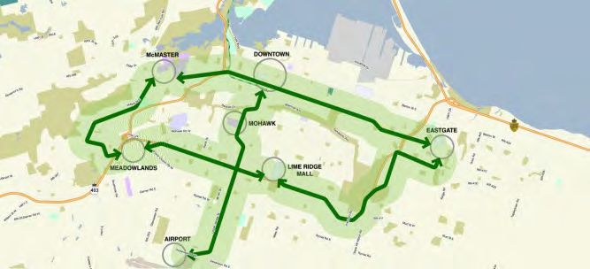
date, committed $9.5 billion to support implementation of the first phase of the plan.
Metrolinx is currently developing an investment strategy to identify methods to further
funding of the proposed infrastructure. Under the Metrolinx Act the investment strategy is
scheduled for completion by June 2013. This was the subject of an earlier report to
Council (report No.) The B-Line has been identified as a 15-year priority project, the A-Line
in the 15-year plan and the T-Line in the 25 year plan.
The Big Move also imagines a future in which key transit stations become mobility hubs,
where transportation modes, including rapid transit, local transit, specialized transit, cycling
and accessible pedestrian networks come together seamlessly.
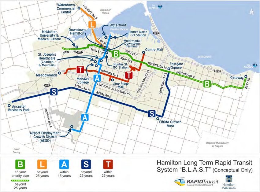
BLAST Network
For Hamilton, the Big Move identified five projects that are recommended for
implementation over the next 25+ years. These included the two projects identified as part
of MoveOntario 2020 (B-Line and A-Line), in addition to three corridors which are referred
to as the T-Line, S-Line and L-Line. In Hamilton, the full system is referred to as “B-L-A-S-
T”. The corridor limits and timeline for implementation, as per the RTP, of each line is
described below:
• “B-Line” - Top 15 Priority Project
- Main/King Corridor – University Plaza to Fifty Road (Metrolinx RTP identifies
short term implementation for McMaster University to Eastgate Square)
- This corridor connects the downtown to major educational, retail, civic and
institutional facilities
• “A-Line” – 15 years
- James/Upper James - Waterfront to Airport (Metrolinx RTP identifies short term
implementation from Downtown to Airport)
- This corridor connects to major recreational, mobility hubs, Downtown, civic
industrial, retail, institutional and Airport facilities
• “T-Line” – 25 years
- Hamilton Mohawk – Centre Mall to Meadowlands (using Mohawk Road)
- This corridor connects the major retail segments of the city as well as industrial
uses
• “S-Line” – 25+ years
- Hamilton Centennial Road/Rymal Road – Eastgate Square to Ancaster
Business Park
- This corridor connects industrial and retail facilities
• “L-Line” – 25+ years
- Connection between Waterdown and Downtown Hamilton (Metrolinx RTP
identifies this corridor as part of the extension of Dundas Street into Waterdown)
- This corridor connects civic, retail and the Downtown facilities.
-2-Exhibit 1: BLAST Rapid Transit Network
Mobility Hub Guidelines
The Mobility Hub Guidelines developed by Metrolinx have been prepared to guide
planning and development at mobility hubs in the GTHA. The City of Hamilton has three
Mobility Hubs as identified in The Big Move: James St. North, Downtown Hamilton and
Mohawk at Upper James, which shall all be subject to these guidelines. These guidelines
focus on the factors that contribute to creating successful mobility hubs, and address
topics such as transit station design, station circulation and access, transit customer
information and wayfinding, land use and urban design surrounding rapid transit stations,
and funding and implementation.
MTO Transit Supportive Guidelines
The Transit Supportive Guidelines include transit-supportive principles and strategies to
promote development patterns that make transit less expensive, less circuitous and more
convenient and to enhance the service and operations characteristics of transit systems to
make them more attractive to potential transit users. These guidelines provide an
-3-important reference for the City of Hamilton in their planning and decision-making
processes. Overall these guidelines provide direction on the following:
• Create a transit-supportive community structure
• Retrofit existing built-up areas to make existing development more transit
supportive
• Coordinate transit and land use decisions to minimize the need for trips and
enhance access to transit services
• Create a regional and local street and block pattern that supports efficient transit
service and maximizes connectivity
• Create complete streets that supports and balance the needs of all users
• Employ a range of targeted strategies and programs to encourage increased
transit ridership
• Locate and design transit stations and stops to enhances accessibility and user
comfort
• Create a transit-supportive urban form
• Develop a family of transit services that cater to different patterns of land use and
communing needs
• Integrate amenities and services to enhance user convenience and comfort.
Provincial Policy Statement (2005)
The Provincial Policy Statement, 2005 was issued under the authority of the Planning Act,
and provides direction on matters of provincial interest related to land use planning and
development. It promotes a provincially ‘policy-led” planning system in which municipal
Official Plans and any planning decisions are consistent with the objectives and details of
the provincial policy. The PPS encourages:
• A high level of Connectivity within and among transportation systems and modes
• land use pattern, density and mix of uses that minimize the length and number of
vehicle trips and support the development of viable choices and plans for public
transit and other alternative transportation modes, including commuter rail and bus
• The integration of transportation and land use considerations
• the protection of corridors and rights-of-way for transportation and transit
Places to Grow: Growth Plan for the Greater Golden Horseshoe. (2006)
The Growth Plan takes the PPS policy framework and outlines more specific policy
direction for the Greater Golden Horseshoe. The Growth Plan is based on a series of
guiding principles which are aimed at building compact, complete and vibrant
communities; managing growth to support a strong competitive economy; making more
efficient and effective use of infrastructure; protecting and enhancing our natural resources
including land, air and water. The Growth Plan encourages that the transportation system
within the GGH will be planned and managed to:
• provide connectivity among transportation modes for moving people and for moving
goods
-4-• offer a balance of transportation choices that reduces reliance upon any single
mode and promotes transit, cycling and walking
• be sustainable, by encouraging the most financially and environmentally
appropriate mode for trip-making
• offer multi-modal access to jobs, housing, schools, cultural and recreational
opportunities, and goods and services
• provide for the safety of system users.
The City’s Official Plan and Transportation Master Plan must conform to the Growth Plan.
Ontario Coroner’s “Pedestrian Death Review” (2012)
The Ontario Coroner's “Pedestrian Death Review” was released in 2012. Key report
recommendations including the following:
• Adopting a “complete streets” approach to guide the development of new
communities and re-development of existing communities;
• The Province of Ontario should develop a Walking Strategy for Ontarians;
• The Ministry of Transportation (MTO), as a stakeholder in developing the above
strategy should solicit feedback regarding opportunities and barriers in policy and
legislation such as the Highway Traffic Act.
• All municipalities in the Province of Ontario should review the collision history of the
road before initiating road reconstruction or resurfacing to proactively seek to
improve pedestrian safety.
• The Ministry of Transportation should create an educational body with
representatives from both governmental and non-governmental organizations
Hamilton is well positioned to meet all of the municipal-related recommendations identified
by Coroner’s Report. The City’s Pedestrian Mobility Plan provides a complete streets
approach to road design and is intended to be applied through the routine accommodation
of road reconstruction, resurfacing and new road construction projects. In addition, the
Hamilton Strategic Road Safety Program (HSRSP) currently includes a review of all
pedestrian collisions and is currently in development of an education and awareness
campaign aimed at distracted and aggressive drivers in order to improve road safety in the
City. Pedestrian education is also a key component of the HSRSP.
The City is a ready and willing partner with the Ministry of Transportation to any program
developed by the Ministry to improve pedestrian safety and to be an active participant in
any undertakings by the Ministry relating to pedestrian activity.
Ontario Coroner’s “Pedestrian Cycling Review” (2012)
The Ontario Coroner's “Cycling Death Review” was released in June 2012. Key report
recommendations include:
• Adoption of a “complete streets” approach – focused on the safety of all road users
– for the benefit of communities throughout Ontario,
-5-• Development of an Ontario Cycling Plan to guide the development of policy,
legislation and regulations and the commitment of infrastructure funding to support
cycling in Ontario,
• Creation of a cycling safety public awareness and education strategy, including
drivers giving adequate space to cyclists,
• Promotion of the use of bike helmets for cyclists of all ages, and
• Prioritizing the development of paved shoulders on provincial highways.
Hamilton is “on track” with the actions as identified in the Coroner’s report, given the
“Share the Road” education campaign designed by the Hamilton Cycling Committee, the
reintroduction of CAN-BIKE courses through the Recreation Division, the City's Strategic
Road Safety Program, and past expansion of the cycling network across the City; but there
are projects as identified in the Council approved cycling master plan that are not
proceeding because of a lack of Council support. Such decisions against cycling
infrastructure are suggested to be reconsidered.
B. City of Hamilton Policy and Strategic Directions
Vision
2020
One of the themes of Vision 2020’s was “Changing Our Mode of Transportation”. This
theme identified two transportation related goals:
• To develop an integrated sustainable transportation system for people, goods and
services, which is environmentally friendly, affordable, efficient, convenient, safe,
and accessible.
• To encourage a shift in personal lifestyle and behaviour towards transportation
choices that enhance personal health and fitness, save money, and have the lowest
environmental cost.
Corporate Strategic Plan objective1.4 (iii)
Develop an integrated, multi-modal, public transportation program, including
implementation of rapid transit, conventional transit, active transportation (e.g. pedestrian,
cycling) and the associated transportation demand management (TDM) plan
• Conventional, Rapid and Inter-Regional Transit: Technical, Financial and Land Use
Considerations (CM11016/PW11064/PED11154/FCS11072) October 13 2011
Urban Hamilton Official Plan & Growth Related Integrated Development Strategy
(GRIDS)
GRIDS was a planning process that identified a broad land use structure, associated
infrastructure, economic development strategy and the financial implications for a growth
to serve Hamilton for the next 30 years. It provided the basis for growth and development
in the City, as defined in the new Rural and Urban Official Plans.
-6-Policies of the Urban Hamilton Official Plan encourage development around transit and
land use and transportation planning integration. In general, the future urban structure
described in the Urban Hamilton Official Plan refines the nodes and corridors identified in
GRIDS, the City’s growth management strategy. The urban structure policies outline the
relationship between a more compact urban form and transit within the urban nodes and
corridors structure of the City.
This Plan recognizes the relationship between the transportation network and its impact on
quality of life and economic development potential. The integrated transportation network
will offer a greater range of transportation mode choice. An improved and efficient
transportation network is a key component of complete communities - creating the vital link
between activities and land uses throughout the City. Improved mode choice can be
accomplished through a better balance between the competing needs of the street
network including cars, transit, active transportation, goods movement and parking. A
balanced integrated transportation network shall contribute to vibrant streets where
pedestrians and cyclists feel comfortable and can co-exist with traffic on the street,
improving health and quality of life.
Nodes and Corridors Urban Structure
The foundation for future growth and development in the City of Hamilton is based on a
Nodes and Corridors structure. The urban system includes a number of key focal points of
activity know as nodes, well connected by a series of corridors. These are key areas for
intensification in the approved growth concept, intended to include a broad mix of land
uses including higher-density residential uses, retail, institutional and recreational uses.
Corridors are also identified as the locations for higher order transit services, linking the
nodes together and facilitating the movement of people from place to place. The nodes
and corridors urban structure is contained within the Urban Official Plan (adopted 2009
and approved in 2011, under appeal).
The location of Nodes and Corridors are identified by Schedule E of the OP (see page 6 of
Appendix A). The following Nodes form part of the urban structure:
• Downtown Urban Growth Centre
• Limeridge Sub-Regional Service Node
• Eastgate Sub-Regional Service Node
• Waterdown Community Node
• Dundas Community Node
• Ancaster Community Node
• Meadowlands Community Node
• Rymal and Upper James Community Node
• Heritage Green Community Node
• Eflrida (Rymal Road East) Community Node
• Stoney Creek Community Node
• Centre Mall Community Node
• Mohawk College/St. Joseph’s Hospital (Mountain Campus) Major Activity Centre
-7-• McMaster University/ McMaster University Medical Centre Major Activity Centre
The Nodes are connected by the following network of Urban Corridors:
• Main-King-Queenston Primary Corridor – West of the Downtown Urban Growth
Centre (UGC) includes Main Street West from McMaster University at
approximately Cootes Drive and King Street West from Longwood Road, both to
Queen Street. East of the UGC includes King Street East and Main Street East to
the Delta. East of the Delta, includes Main Street East to the Queenston traffic
Circle and then Queenston Road to the Eastgate Sub-Regional Service Node at
Centennial Parkway.
• James - Upper James Primary Corridor – Includes James Street north and south of
the UGC to the escarpment and James Mountain Road up the escarpment. Above
the escarpment, includes West 5th Street to Fennell Avenue, Fennell Avenue from
West 5th Street to Upper James Street and Upper James Street from the
escarpment to Airport Road.
• Main/Osler Secondary Corridor - Includes Osler Drive/Main Street West from west
of Grant Boulevard to approximately Cootes Drive.
• Highway 8 Secondary Corridor - Includes Highway 8 from the Eastgate Sub-
Regional Service Node at Centennial Parkway to Fruitland Road. A Potential
expansion of the Secondary Corridor has been identified along Highway 8 from
Fruitland Road to Fifty Road and northerly to the future multi-modal transit hub.
• Centennial – Upper Centennial Secondary Corridor - Includes Centennial Parkway
from north of Barton Street to the escarpment and Upper Centennial above the
escarpment to the Eflrida (Rymal Road East) Community Node.
• Rymal Road Secondary Corridor - Includes Rymal Road from the Rymal and Upper
James Community Node to the Eflrida (Rymal Road East) Community Node.
• Mohawk Road Secondary Corridor - Includes Mohawk Road West from the
Linc/Meadowlands Community Node to the Limeridge Sub Regional Service Node
at Upper Wentworth Street.
• Ottawa Street Secondary Corridor – Includes Ottawa Street from Main Street East
to the Centre Mall Community Node at Barton Street.
The above noted Corridors correspond generally with the Potential Rapid Transit Line
(B.L.A.S.T.) network on Appendix B of the Official Plan. The Urban OP, established
the City’s corridors as a significant opportunity for creating vibrant pedestrian and
transit oriented places through investment in infrastructure, residential intensification,
infill and redevelopment and careful attention to urban design. Policy E.2.4.13 of the
Official Plan specifically states that Corridor studies or secondary planning shall be
-8-undertaken for the Urban Corridors to provide greater direction on mix of uses, heights,
density, built form and design.
Transportation Policy Papers 2004
The City of Hamilton Transportation Master Plan sets out the long term approach to
providing transportation services in the City. A series of Policy Papers were prepared as
the basis for the City-wide Transportation Master Plan. These were developed in
conjunction with the Growth Related Integrated Development Strategy (GRIDS) and
adopted by Council in May, 2006. The Transportation Master Plan was developed as three
distinct phases. The first phase consisted of the technical calibration of the existing
transportation model to reflect current transportation conditions in Hamilton. The second
phase focused on the development of 23 policy papers in the following areas: Travel
Demand, Urban Development, System Performance, Infrastructure Planning and
Infrastructure Financing. The Policy Papers were endorsed by Council on November 24,
2004.
Transportation Master Plan 2007
The third phase of the planning process was the development of the Transportation Master
Plan (TMP) itself. The TMP was approved by Council in May, 2007.
Strategic Transportation Solution
The City of Hamilton overriding transportation strategy is to rely on transit and travel
demand management, in combination with road capacity optimization to solve
transportation problems, before looking to road expansion. It is also recognized that
adequate road infrastructure is essential for economic development and that
strategies must reflect a balanced transportation network.
The following table summarizes the objectives and guiding principles adopted as
part of the TMP.
Targets for transportation demand were established that reflect long standing
direction of the City of Hamilton to reduce its environmental impacts while
increasing mode choice and accessibly for its residents. These strategic targets,
summarized in the table below, are based on significantly increasing the portion of
trips made by public transit, walking, cycling, as well as reducing trips through travel
demand management. Near term targets are reflected of the 2011 horizon and long
term targets are reflective of the 2021-2031 timeframe.
-9-Exhibit 2: Transportation Master Plan Objectives and Principles
In 2031, the City of Hamilton’s transportation system will:
Objective Offer safe and convenient access for individuals to meet their daily needs
1
Principle
Transportation facilities and services should be safe, secure and barrier-free
1(a)
Principle Each transportation mode should have an acceptable level of service
1(b)
Principle Non-travel alternatives and shorter trips should be encouraged
1(c)
Objective Offer a choice of integrated travel modes, emphasizing active transportation,
2 public transit and carpooling
Principle
Alternatives to single-occupant vehicle travel should be practical and attractive
2(a)
Principle Transportation facilities and services should be continuous and seamlessly
2(b) integrated
Principle The health benefits of active lifestyles should be recognized and promoted
2(c)
Objective Enhance the liveability of neighbourhoods and rural areas
3
Principle
Transportation facilities should reflect and complement their community context
3(a)
Principle Noise and other undesirable impacts of traffic on residential areas should be
3(b) minimized
Objective Encourage a more compact urban form, land use intensification and transit-
4 supportive node and corridor development Investment in transit-supportive
Principle land uses should be encouraged by quality public transit services and
4(a) facilities Transportation facilities should meet current needs while remaining
Principle adaptable to those of the future Zoning, urban design and parking
4(b) management strategies should minimize land consumed by automobile travel
Principle
4(c)
Objective Protect the environment by minimizing impacts on air, water, land and natural
5 resources
Principle
The use of greenspace for new infrastructure should be minimized
5(a)
Principle Transportation technologies and behaviours should reduce energy consumption and
5(b) air emissions
Principle The impacts of surface water runoff from transportation facilities should be
5(c) minimized
Objective Support local businesses and the community’s economic development
6
Principle
The efficiency of goods movement to, from and within the City should be maximized
6(a)
Principle Businesses and institutions should remain accessible to employees and visitors
6(b)
Objective Operate efficiently and be affordable to the City and its citizens
7
Principle
Maximum value should be extracted from existing facilities and services
7(a)
Principle Decisions should take into account the life-cycle costs of transportation facilities and
7(b) services
Principle Transportation funding opportunities involving other governments, the private sector
7(c) and individual users should be considered
-10-Exhibit 3: Transportation Master Plan Targets
Plan Elements
Public Transit
The TMP proposed a Higher Order Transit network for the City along with a number of
related transit enhancements. A Key Element is to build a Bus Rapid Transit (BRT)
network. Three primary corridors for BRT and ultimately other forms of Rapid Transit
emerged from the working paper that was prepared:
• A Lower City east-west corridor on King Street/Main Street/ Queenston Road
• A Central North-South Corridor on James Street and Upper James via Mohawk
College
• A Mountain East-West Corridor on the Lincoln Alexander Parkway or parallel facility
In addition, the following Park and Ride locations were noted as a key priority:
• Meadowlands area
• Eastgate mall area
• Mount Hope (at or near Mountain Transit Terminal)
• Elfrida
• Winona
-11-The TMP also proposed a number of improvements to conventional and accessible transit
and supporting actions:
• Transit Service Extensions
• More compact mixed-use development around nodes and corridors throughout the
City
• Comprehensive route restructuring study to determine how transit service should
change in suburban areas
• Ensuring access for persons with disabilities
• Utilizing the Smart Commute Program to promote alternative strategies
• Guidelines on Transit-Supportive Densities
In terms of financial implications, it was estimated that the conventional transit fleet would
need to expand from the current 205 vehicles to approximately 440 buses by 2031. At the
time of preparation of the TMP, the cost was estimated at $91 million, or $3.6 million per
year over 25 years. Additional associated transit capital costs related to transit facilities
and the implementation of Bus Rapid Transit were an estimated 2007 cost of $51 million
and $159 million respectively. Approximately $300 million would have to be invested in
the conventional transit system over the next 25 years, or approximately $12 million per
-12-year. This does not include the cost of replacing aging buses. Overall, it was projected
that at least $20 million per year would need to be invested in the transit system.
Exhibit 5 provides a high level status of proposed infrastructure and projects. A more
detailed review of transit operations and measures recommended to increase the role of
transit in meeting current and future transportation needs is provide in Appendix B2 –
Summary - Hamilton Street Railway Operational Review (March 2010).
Cycling Network
The TMP established a high level cycling network. Key aspects from a bicycle commuting
perspective include:
• On- and off-street connections between McMaster University, Westdale
• neighbourhood, and Downtown Hamilton;
• On-street east-west route across lower Hamilton;
• Direct and protected on-street north-south routes in upper Hamilton, in addition to
• existing local routes;
• New Escarpment crossings, including a proposed dedicated inclined railway for
• pedestrians and cyclists in vicinity of Upper Wentworth Street and Concession
Street.
Key aspects from a recreational cycling perspective include:
• Trail extensions and enhanced trail connections for the Harbour Waterfront Trail,
Lake Ontario Waterfront Trail, Escarpment Rail Trail, and the Chippewa Rail Trail,
among others; and
• New Escarpment crossings.
Cycling Master Plan 2009
The high level cycling network established in the 2007 TMP has been further detailed
by the adoption of the cycling master plan Shifting Gears 2009. This plan
recommends a network of multi-use trails and bike lanes that are to be completed in
order to achieve City goals that are strongly endorsed by the City’s Strategic Plan;
specifically, health, safety, and sustainability. Some of these projects are stand-alone
retrofit projects, some are embedded in road reconstruction projects, some are part of
new streets in new developments, and some are multi-use trail projects.
Shifting Gears 2009 proposes approximately 550 km of bike lanes of which 150 km
currently exist (~25%); and 190 km of major multi-use trails of which 140 km currently
exist (~75%). There are also opportunities to utilize some convenient connections on
streets with low traffic volumes simply with directional signage (i.e. no bike lanes are
required); and over 90% of that recommended network is completed.
Paved shoulders are also recommended on critical roads in rural areas of the City.
This aspect of the cycling master plan was not identified as a priority in the report to
-13-PWC/Council in 2009 because it was recognized that achieving a well-connected
cycling network in the urban area as a priority will provide a greater benefit to a larger
proportion of citizens. Currently, approximately 5% of the recommended network of
paved shoulders exists.
Section 6 of the cycling master plan “Implementation Strategy” addresses the annual
implementation costs, the approval process for individual projects, annual maintenance
costs, funding sources both internal and external, and benefits (i.e. return on
investment). The plan assumes a 20 year implementation schedule, thus an estimated
$2.5 million annually to complete the entire urban and rural cycling network.
The PWC minutes for June 15 2009 include the following approved motion as stated as
item 8 (c) regarding PW09068:
(c) That, upon completion of the thirty day public review period, the General Manager,
Public Works, be authorized and directed to schedule the recommended projects for
consideration in the 2010 and future years Capital Budget deliberations;
Regarding implementation costs, report PW09068 stated that:
“… to complete the cycling network in a timely fashion, that the annual budget for
cycling infrastructure be increased, subject to budget deliberations. The starting point
for the budget process will be an annual request for $1,250,000. While $1,250,000
annually is less than the amount required to complete the entire network in twenty
years, it will allow for good success on the urban portion and is compatible with staff’s
ability to undertake these projects.”
A review of spending on cycling infrastructure in previous years was conducted as per a
request of PWC, and that report (PW10063) determined an estimated expenditure for all
cycling investment, from amalgamation (January 1, 2001) to December 2008, to be
approximately $7.1 million, or $890,000 per year.
The following table shows what the approved expenditure has been since 2009. The City
has been making solid progress implementing cycling infrastructure, especially given the
financial constraints facing municipalities. Notwithstanding, it should be noted that 5% of
the network would need to be constructed annually to complete the cycling network in 20
years (i.e. 2029), and that level of implementation has not been achieved. In the plan, the
approximate density of cycling infrastructure in the urban area is approximately one
corridor every 2 km. Exhibit 4 indicates that the City has been able to increase the
average annual expenditure to $1.23 million, which is comparable to the $1.25 million as
suggested in the PWC report that approved the cycling master plan in 2009 (PW09068).
(Note the table does not include cycling infrastructure constructed as part of new
developments). These financial numbers do not include the $14 million that was spent on
the Red Hill Valley Trail, including the crossing of the QEW, as the funding for that project
was provided from the Province.
-14-Exhibit 4: Cycling Expenditure Annually Since 2009
Portion of Portion of
Embedded in
CMP CMP
Bicycle Individual
Identified Projects Total
Year Route Road
Projects* Plus Cost
Projects Reconstruction
(by Paved
Projects
length) Shoulders
2009 1% 1% 300,000 600,000 900,000
2010 3% 2% 300,000 1,835,000 2,135,000
2011 1% 1% 300,000 200,000 500,000
2012 3% 2% 300,000 1,275,000 1,575,000
2013
6% 3% 300,000 730,000 1,030,000
planned
* “Identified Projects” include bike lanes and major multi-use trails
Exhibit 6 summarizes the status of proposed actions and projects.
Pedestrian Network
The success of the TMP strategic solution requires a holistic approach to mobility
including initiatives to:
• Improve the quality and extent of pedestrian and bicycle infrastructure;
• Encourage shorter average distances between home, work and other major
destinations;
• Increase awareness of non-motorized networks and safety requirements;
• Enhance the co-ordination of transit trips with walking and cycling trips; and
• Ensure the bicycle and pedestrian friendliness of new development.
DRAFT Pedestrian Master Plan
Establishing a Pedestrian Mobility Master Plan was a recommendation from the 2007
council approved City-wide Transportation Master Plan, the 2008 International Charter
for Walking (endorsed by City Council), the Recreational Trails Master Plan, plus
numerous other City initiatives that identify pedestrian mobility as an essential part of
City-making. In November 2010, the Pedestrian Mobility Master Plan was initiated and
is being undertaken consistent with Phase 1 and 2 of the Environmental Assessment
process. A staff report will be going forward to Council in early 2013 for endorsement
of the Pedestrian Mobility Master Plan.
Establishing a Pedestrian Mobility Master Plan was a recommendation from the 2007
council approved City-wide Transportation Master Plan, the 2008 International Charter
for Walking (endorsed by City Council), the Recreational Trails Master Plan, plus
numerous other City initiatives that identify pedestrian mobility as an essential part of
City-making. In November 2010, the Pedestrian Mobility Master Plan was initiated and
-15-is being undertaken consistent with Phase 1 and 2 of the Environmental Assessment
process.
The City of Hamilton is only the second municipality in Ontario to undertake a
pedestrian-specific plan (Ottawa is the other municipality) and the first to address the
pedestrian environment at this level of detail for a master plan. This demonstrates the
City’s commitment and innovation in accommodating pedestrian mobility issues, and
active transportation within the City.
The Pedestrian Mobility Plan identifies the need to increase pedestrian safety and the
number of walking trips to achieve the City-wide Transportation Master Plan targets. In
addition, the study evaluated existing pedestrian policies, procedures and programs in
order to develop a sustainable implementation strategy that will identify priorities for
improvements and performance indicators.
The Pedestrian Mobility Plan is consistent with the City-wide Strategic Plan Vision and
acts as one of the catalysts to achieving this broader vision for the City.
The key highlights of the plan are as follows:
• Neighbourhood pedestrian planning should characterize the health related attributes
(such as the demographic profile) of its residents in order to calibrate the overall age
friendly land use and transportation approaches needed. Once set, physical design
measures should be selected and employed.
• Holistic approach to designing the street to accommodate all users, including the
pedestrian in order to meet all travel requirements.
• Context Sensitive Design that will encourage the provision of amenities within the
right of way that make public transit, pedestrian movement and cycling effective
alternative transportation modes including better access to interesting destinations,
increased shade from trees, differing sidewalk widths, pedestrian plazas.
• Land use patterns that are inter-related with pedestrian facilities and oriented to
streets by maximizing existing planning policies.
• Enhancing and/or developing supportive policy that addresses matters such as
urban Braille, transportation demand management, walking to school programs,
education, enforcement and age sensitive design.
Road Network
The proposed TMP road network strategy generally reflects committed and planned
improvements identified through previous studies. In total, approximately $418 million
worth of roadway improvements were recommended. Even assuming the implementation
of committed improvements and the most aggressive scenario with respect to travel
demand management, it is projected that there will still be some remaining capacity
deficiencies including those listed below.
Downtown and Central Escarpment Crossings: many of the Escarpment crossings are
projected to continue to experience some congestion. Major expansions to the Downtown
-16-road network are not consistent with the goals of promoting a pedestrian and transit
supportive environment; therefore other approaches will be required:
• Accept some congestion as part of a successful Downtown
• Implement aggressive Transportation Demand Management (i.e. parking pricing)
• Additional transit improvements
• Postpone proposed conversion of east-west streets to two-way
Red Hill Valley Corridor: In the longer term, the Red Hill Valley Parkway may experience
capacity limitations due to longer distance travel. This can be postponed by implementing
additional Transportation Demand Management and/or auto disincentives (i.e. road
pricing).
Highway 403 Corridor: This Provincial Highway corridor experiences regular congestion
and this is expected to increase due to the growth in surrounding municipalities. Strategies
to improve the person carrying capacity of the Highway 403 are required and could include
the implementation of High Occupancy Vehicle lanes (similar to Highway 404 and Highway
403 in Mississauga). Potential improvements require on-going discussion with MTO.
New Link to Airport – Appropriate goods movement access to the Hamilton International
Airport from the north and east has been identified as a significant issue. The 2005
Hamilton Goods Movement Study identifies the need to provide a connection between the
Red Hill Valley Parkway and the Airport as a designated truck route.
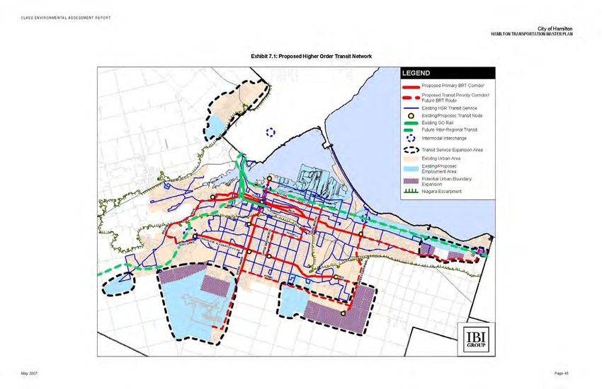
Exhibit 7, attached, Illustrates the Proposed Road Infrastructure Improvements that
resulted from the May 2007 Transportation Master Plan and the status of the
recommended road projects. As can be seen in the summary, the City is making
reasonable progress on road infrastructure, with approximately half of the road projects
either completed or in progress. However, as many of these projects are still in the
planning and/or design phases, there is still over $400 million worth of infrastructure
proposed over the term of the Master Plan (2031).
Goods Movement
A goods movement study, the Hamilton Goods Movement Study (June 2005), was
undertaken for the City. Key recommendations are to:
• Resolve freight bottlenecks including short term measures such as improving
signage for truck routes to and from major industrial areas, to and from the Port and
to and from the Airport.
• Re-examine specifications for truck routes within the City to ensure that clearances
are appropriate for traffic entering and leaving the Port area in particular. This would
involve more routine operation of oversized loads from the Port to eastbound and
westbound destinations. A truck route study will be initiated by the City in 2007.
• Establish policies to accommodate 24-hour freight operations in the Port, Airport,
and rail freight facilities.
-17-• Support Hamilton Port Authority initiatives concerning establishment of 12 month
operations, which involves eliminating or minimizing the three month closure of the
Burlington Lift Bridge each winter for maintenance.
City of Hamilton Recreational Trails Master Plan
The Recreational Trails Master plan prescribes a comprehensive multi-purpose off-road
recreational trail system to connect natural areas, cultural features and major land use
destinations within the City of Hamilton. This system links to the on-road commuter
systems and will be fully integrated into larger regional, and national network of trails. This
Trails Master Plan provides direction on a system wide basis with respect to the following
among others:
• Plan for the development and operation of a trail system within the City of Hamilton
that provides for a wide range of recreational opportunities;
• Connect major urban and rural land uses by providing multi-purpose trails and
integrate the system with on-street cycling and sidewalk systems.
• Support public and private transportation demand management plans by providing
alternative modal interconnections between residential, employment, commercial
and institutional centres;
• Provide a safe cycling and pedestrian environment;
• Promote physical activity and healthy lifestyles
City of Hamilton Transit Oriented Development (TOD) Guidelines (2010)
The City of Hamilton TOD guidelines provide direction to guide policies and development
within the City in order to encourage a better integration of land use and transportation.
The core components of TOD should include: compact, mixed use, highly pedestrianized
areas with connections to transit. The guidelines serve as a user friendly guide that
identifies the components that should be part of development or redevelopment and are a
useful tool to help implement the existing policy such as the Official Plan and
Transportation Master Plan. The TOD guidelines are based on the following principals:
• Promote Place Making – Creating a Sense of Place
• Ensure a Mix of Uses/Appropriate Land Uses
• Address Parking Management
• Focus on Urban Design
• Create Pedestrian Environments
• Require Density and Compact Urban Form
• Respect Market Conditions
• Take Comprehensive Approach to Planning
• Plan for Transit and Promote Connections (for all modes)
• Promote Partnerships and innovative Implementation
-18-Hamilton Transit Ridership Growth Plan
The guiding principles for the transit ridership growth plan are:
• The need to improve services and safety for existing riders so they become
ambassadors for transit;
• Adoption of strategic approach that considers transit’s role in the larger
transportation, social, economic and environmental context, including the ability for
transit to facilitate the City’s growth management objectives and policies for a more
balanced transportation system;
• The need to pursue initiative that are cost-effective with high visibility, and those
that improve the image of the transit system;
• The benefits of marketing the transit system as an important city service and one
that requires attention to position Hamilton for future economic success, community
well-being, affordability for passengers and environmental sustainability.
Main King Queenston Corridor Strategy Study
In 2010, work began on the first corridor planning study, the Main, King, Queenston (B-
Line) Nodes and Corridors Land Use Planning Study, to implement the policy framework in
the City of Hamilton. Background studies and consultation revealed a number of
challenges and opportunities related to the Corridor. Changing demographics combined
with other factors, can result in declining investment, image and services along the
Corridor. One of the key outcomes of consultation is the recognition of the need for
reurbanization along the Corridor. A key element of revitalization and transformation is
intensification. Therefore, a central element of the Corridor Plan will focus on how to
achieve intensification in a manner that brings vitality to the Corridor while respecting
established neighbourhoods.
In Arpil 2012 Council approved a corridor development option, Focused Reurbanization,
which would promote the Corridor as a mixed use, transit oriented corridor and would
provide the necessary direction to achieve the City’s intensification targets. The approved
corridor concept applies a variety of built forms and ground level activity scenarios for the
corridor with the focus of reurbanization activity concentrated in focal areas (transit stops).
Land assembly would be facilitated in focal areas to promote mid-rise buildings. This
Option provides a balanced approach, facilitating and allowing for reurbanization and
intensification, while addressing potential impacts on, and fit with, adjacent
neighbourhoods. As part of the next steps, a detailed strategy and implementing Official
Plan and Zoning By-law Amendments for the Main, King, Queenston (B-Line) Corridor will
be prepared. Approximately 11,400 additional residential units, or approximately 19,145
people, could potentially be added along the Corridor (excluding the downtown Urban
Growth Centre).
-19-City Wide Corridor Planning Principles and Design Guidelines
In April 2012, the City of Hamilton adopted City Wide Corridor Planning Principles and
Design Guidelines. The purpose of the Guideline is to provide a set of planning principles
and implementing design guidelines for Corridors in the City of Hamilton. These principles
and guidelines provide direction for new development, public realm investments and future
planning studies along primary and secondary Corridors across the City. The following are
the key principles proposed in the document to guide the development of Corridor planning
initiatives:
Corridors should be planned and developed to:
(a) Support and facilitate development and investment that contributes to the
economic and social vitality of the Corridor and adjacent neighbourhoods.
(b) Promote and support development which enhances and respects the character
of existing neighbourhoods where appropriate and creates vibrant, dynamic, and
livable urban places through high quality urban design.
(c) Develop compact, mixed use urban environments that support transit and active
transportation.
(d) Promote and support an innovative sustainable built environment that uses
resources efficiently and encourages a high quality of life.
(e) Identify areas of change as the locations for new development along Corridors.
The guidelines were prepared considering development potential as it relates to typical
built form and property size. They provide guidance on development along corridors
including issues such as maximum building height (related to property depth and street
width), minimum building height, landscaping, parking and loading, relationship of
buildings to the street (pedestrian focus area, flexible area, residential character area) ,
setbacks, sidewalks and streetscapes and land assembly to provide for developable
parcels, shadow impacts, and precinct site development.
-20-Transportation Master Plan Status of
Implementation Summary Tables
-21-2007 Cost 2012 Cost
Category Project Description Status Planning Design Implementation
(Millions) (Millions)
1
East-West Lower City Corridor (King/Main/Queenston) $14.00 $15.26 Not Considered
Central North-South Corridor $65.00 $70.85 In Progress
BRT
East-West Mountain $70.00 $76.30 No Action - - -
Other Corridors $10.00 $10.90 No Action - - -
Meadowlands $0.20 $0.22 No Action - - -
Mount Hope $0.20 n/a2 In Progress
Park & Ride Locations Elfrida $0.20 $0.22 No Action - - -
Eastgate Mall $0.20 $0.22 Complete
Winona $0.20 $0.22 No Action - - -
James Street North (Liuna) n/a n/a In Progress
Commuter Rail & Bus
Centennial Pkwy @ QEW n/a n/a In Progress
(Mobility Hubs)
Stoney Creek n/a n/a No Action - - -
Eastgate Mall Terminal $1.50 $1.64 Complete
Transit Terminals Downtown (McNab Terminal) $15.00 $16.35 Complete
Mohawk College Terminal $4.00 n/a2 In Progress
1
LRT technology chosen for further consideration
2
Metrolinx Quick Wins Funding
-22-Exhibit 6: Cycling Master Plan Implementation Status
Action Action
Action Action Lead
Priority Status
Traffic Engineering Section,
Proceed with implementation of the planned network High In progress
P.W.
Investigate design options for a cycling facility connecting Greensville Traffic Eng. Section, P.W. to High (as EA Study
to Dundas along Hwy 8 initiate and determine lead is underway) completed
Aim to incorporate signal activation for cyclists with all future signal Traffic Engineering Section,
High In progress
design P.W.
Traffic Engineering Section,
Offer cycling education to teens and adults – possibly CAN-BIKE High In progress
P.W.
Strategic Planning and Rapid
Adding more enclosed bike parking facilities throughout the City High Implementing
Transit Section, P.W.
Complete an inventory of bike racks at City facilities and address Traffic Engineering Section,
High In progress
deficiencies P.W.
Traffic Engineering Section,
Monitoring, Review & Council Updates High Implementing
P.W.
Discuss with Haldimand County the connection of the Chippawa rail Traffic Eng. Section, P.W. to
Medium In progress
Trail south of Haldibrook Rd initiate and determine lead
Further promote the existing Cyclemania program provided by the Traffic Eng. Section, P.W. to
Medium Implementing
Hamilton Police Service initiate and determine lead
Consideration of adding a bike icon to street name plates on streets Traffic Engineering Section,
Medium No action
that provide specific cycling infrastructure P.W.
Consider additional wayfinding signage – including distance Traffic Engineering Section,
Medium Implementing
information P.W.
Investigate bicycle routing issues on streets that are being considered Strategic Planning and Rapid
Medium In progress
for rapid transit Transit Section, P.W.
Traffic Engineering Section,
Review City bylaws to assess consistency with Provincial laws Medium In progress
P.W.
Discuss with the Ministry of Transportation facilities proposed in the Traffic Eng. Section, P.W. to
Low In progress
plan beside Provincial highways initiate and determine lead
Discuss with Haldimand County a connection along the existing Hwy
Traffic Eng. Section, P.W. to
6 corridor - but likely after the construction of the planned Hwy 6 west Low No action
initiate and determine lead
of the existing corridor south of White Church Rd
Investigate bike friendly facilities at existing escarpment stairs at Traffic Eng. Section, P.W. to
Low In progress
Dundurn St and Wentworth St initiate and determine lead
-23-Anticipated 2007 Cost 2012 Cost
Road Name From To Description Status Planning Design Implementation
Timing (Millions) (Millions)
Airport Access Road RHVP Hwy 6 New Road 2007-2011 TBD TBD No Action - - -
Ancaster New E/W Road
(Trinity@Wilson Development) Tradewind/Cormorant Trinity New Road
2007-2011 $2.40 $2.62 In Progress
Ancaster New Midblock Collector
(Trinity@Wilson Development) Cormorant Tradewind New Road
Arvin Avenue McNeilly existing end New Road 2007-2011 $3.89 $4.24 In Progress
Barton Street Fruitland Fifty TWLTL Beyond 2021 $12.57 $13.70 No Action - - -
Baseline Road Winona North Service TWLTL 2007-2011 $1.48 $1.61 Complete
Fletchers 3 km W of Hwy 56 Road Widening
Binbrook Road 2012-2021 $7.80 $8.50 In Progress
E & W of Hwy 56 Intersection Improvements
Bold Street Queen James Two-way Conversion 2007-2011 $0.10 $0.11 No Action - - -
Centre Road/Hamilton Street Northlawn John TWLTL 2012-2021 $2.12 $2.31 No Action - - -
Community Avenue Stoney Creek Limits Teal Urbanization 2012-2021 $0.99 $1.08 No Action - - -
Dartnall Road StoneChurch Dickenson New Road north of Dickenson TWLTL 2012-2021 $8.57 $9.34 In Progress
Dickenson Road W of Glover Glancaster Urbanization and turn lanes 2012-2021 $12.35 $13.46 No Action - - -
Duke Street Queen James Two-way Conversion 2007-2011 $0.10 $0.11 No Action - - -
Falcon Road Fifty West Limits Urbanization 2007-2011 $0.19 $0.21 Complete
Fifity Road QEW Hwy 8 Road Widening Beyond 2021 $2.32 $2.53 No Action - - -
Fletcher Road Rymal Binbrook Left Turn Lanes 2012-2021 $8.10 $8.83 In Progress
Fruitland Road Arvin Barton Road Widening Beyond 2021 $0.79 $0.86 No Action - - -
Garden Avenue Teal Pinelands Urbanization 2007-2011 $0.48 $0.52 No Action - - -
Garner Road / Wilson St / Hwy 2 50m E. of Glancaster Rd Hwy 52 Road Widening/TWLTL 2012-2021 $28.95 $31.56 In Progress
Garth Street StoneChurch Rymal TWLTL 2007-2011 $1.60 $1.74 In Progress
Garth Street Extension Twenty Dickenson New Road Beyond 2021 $3.06 $3.34 No Action - - -
Glancaster Road Hwy 53 Twenty Add Left Turn Lanes 2007-2011 $1.56 $1.70 No Action - - -
Glover Access Road Glover North Service Urbanization 2007-2011 $0.75 $0.82 Complete
Glover Road Rymal Dickenson Urbanization 2007-2011 $6.26 $6.82 In Progress
Golf Links Road McNiven Kitty Murray TWLTL 2012-2021 $2.07 $2.26 No Action - - -
Governor's Road Bridlewood Osler TWLTL 2012-2021 $5.23 $5.70 In Progress
Hamilton Drive Hwy 403 0.35km South Intersection improvements 2007-2011 $0.65 $0.71 No Action - - -
Hwy 20 Ridge south of Mud Intersection improvements/TWLTL 2012-2021 $4.65 $5.07 No Action - - -
Hwy 8 Hillcrest Park TWLTL Beyond 2021 $1.97 $2.15 In Progress
Hwy 8 Bond Dundas Limits TWLTL Beyond 2021 $6.27 $6.83 No Action - - -
Hwy 8 Dewitt Hamilton Boundary Road Widening/TWLTL Beyond 2021 $10.54 $11.49 In Progress
Hwy 5/6 interchange 2012-2021 $16.90 $18.42 In Progress
Jerseyville Road Martin Lloyminn TWLTL 2012-2021 $6.99 $7.62 No Action - - -
Jones Road Barton South Service Urbanization 2012-2021 $1.94 $2.11 No Action - - -
Kenmore Avenue Arvin Barton Urbanization 2012-2021 $0.86 $0.94 No Action - - -
King Street Queen Wellington Two-way Conversion 2007-2011 $2.98 $3.25 Not Considered - - -
Leaside Avenue Arvin Barton Urbanization 2012-2021 $0.65 $0.71 No Action - - -
Lewis Road Barton South Service Urbanization 2007-2011 $1.75 $1.91 No Action - - -
MacNab Street Cannon Guise Two-way Conversion 2007-2011 $0.25 $0.27 No Action - - -
McNeilly Road Barton South Service Urbanization 2007-2011 $1.87 $2.04 Compelte
McNiven Road Rousseaux Golf Links Road Widening 2007-2011 $1.72 $1.87 No Action - - -
Millen Road South Service Hwy 8 TWLTL 2012-2021 $4.92 $5.36 In Progress
Mohawk Road McNiven Hwy 403 Road Widening 2007-2011 $3.55 $3.87 No Action - - -
-24-Nebo Road Rymal Dickenson TWLTL/Urbanization 2012-2021 $5.50 $6.00 No Action - - -
North Service Road Gray's East City Limits Road Widening/Urbanization 2012-2021 $18.94 $20.64 No Action - - -
Oriole Avenue South Service Wiona Urbanization 2007-2011 $1.08 $1.18 In Progress
Parkside Drive Braeheld Hwy 6 TWLTL/Road Widening 2012-2021 $9.12 $9.94 In Progress
Pinelands Avenue Community South Service Urbanization 2007-2011 $0.65 $0.71 No Action - - -
Queen Street Cannon Stuart Road Narrowing (Road Diet) 2012-2021 $0.42 $0.46 No Action - - -
Regional Road 56 South City Limits Street M TWLTL/Road Widening 2012-2021 $21.72 $23.67 No Action - - -
Rymal Road Ryckermans Upper James Road Widening 2012-2021 $39.55 $43.11 In Progress
Scenic Drive Old City Limits Lavender Dr. S. Leg TWLTL 2007-2011 $3.05 $3.32 No Action - - -
Seabreeze Crescent Glover MnNeilly Urbanization 2007-2011 $1.35 $1.47 In Progress
Seaman Street South Service Dewitt Urbanization 2007-2011 $1.30 $1.42 No Action - - -
Shaver Road Hwy 403 Wilson TWLTL/Urbanization 2012-2021 $4.08 $4.45 No Action - - -
South Service Road Millen Gray's Road Widening 2012-2021 $6.44 $7.02 No Action - - -
Southcote Road Golf Links Garner Road Widening 2012-2021 $5.73 $6.25 No Action - - -
Springbrook Road Meadowlands Garner TWLTL 2012-2021 $2.40 $2.62 No Action - - -
Stone Church Road Pritchard Upper James TWLTL 2007-2011 $3.25 $3.54 Complete
Sulfer Springs Road Wilson Mansfield Urbanization 2012-2021 $0.75 $0.82 Complete
Sunnyhurst Avenue Barton North End Urbanization 2012-2021 $1.12 $1.22 No Action - - -
Teal Avenue Garden South Service Urbanization 2012-2021 $0.65 $0.71 No Action - - -
Trinity Church Road Golf Club Stone Church Urbanization/Left turn lanes/New Road 2012-2021 $12.38 $13.49 In Progress
Trinity N'hood/ROPA 9 Collector Second W Highland New Road 2007-2011 $2.23 $2.43 Not Considered
Trinity Road 1km S. of Wilson Hwy 403 Road Widening Beyond 2021 $6.28 $6.85 No Action - - -
Twenty Road Glancaster Glover TWLTL 2012-2021 $9.76 $10.64 In Progress
Upper Gage Mohawk Thornley TWLTL 2007-2011 $2.40 $2.62 No Action - - -
Upper James Rymal Former City Limits TWLTL 2012-2021 $1.92 $2.09 No Action - - -
Upper Mount Albion Mud Rymal TWLTL/Road Closure 2012-2021 $4.75 $5.18 In Progress
Upper Ottawa Extension Former City Limits Twenty New Road 2012-2021 $2.05 $2.23 No Action - - -
Upper Sherman Rymal LINC TWLTL 2012-2021 $4.67 $5.09 No Action - - -
Upper Wellington Rymal Stonechurch TWLTL/Road Widening 2012-2021 $5.63 $6.14 In Progress
New E-W Link W of Hwy 6 new N-S Link New Road/Intersection Improvements
Parkside Drive Churchill new N-S Link Urbanization/Road Widening
New N-S Link Parkside Dundas New Road 2012-2021 $18.02 $19.64 In Progress
Dundas Street/N-S Link W of N-S link E of N-S link Intersection Improvements
Dundas Street new N-S link Hamilton Boundary Road Widening
Waterdown Road Mountain Brow Hwy 403 Road Widening
Mountain Brow Road Waterdown new N-S Link Road Widening 2012-2021 $18.20 $19.84 In Progress
New N-S Link Mountain Brow Dundas New Road
Weir's Lane Hwy 8 Escarpment Urbanization 2007-2011 $2.81 $3.06 In Progress
Wellington Street Hunter Young Road Narrowing (Road Diet) 2007-2011 $0.31 $0.34 No Action - - -
West 5th Rymal Limeridge TWLTL 2012-2021 $5.02 $5.47 In Progress
Wilson Street Hamilton Halson Road Widening 2012-2021 $7.02 $7.65 In Progress
York Blvd/Wilson Street Bay Wellington Two-way Conversion 2012-2021 $2.28 $2.49 Complete
Gross $415.02 $452.37 Complete 26 9 7
Projects Identified 85 Complete $10.57 $11.52 3/4 Complete 4 3 0
Projects Completed 7 8.2% Net $404.45 $440.85 1/2 Complete 8 7 6
Projects in Progress - EA complete/underway/portion built 34 40.0% Initiated 3 3 0
Projects No Longer Considered 2 2.4% Not Started 42 61 70
Projects Outstanding 42 49.4% Not Considered 2 2 2
Total 85 85 85
-25-You can also read