APPENDIX L REPORT - Hamilton City Council
←
→
Page content transcription
If your browser does not render page correctly, please read the page content below

REPORT

                                                                    APPENDIX L

Peacocke Structure Plan
Area: Ecological Significance
Assessment

Prepared for
Hamilton City Council
Prepared by
Tonkin & Taylor Ltd
Date
July 2021
Job Number
1007479.0040.v4

 Tonkin & Taylor Ltd                                                               July 2021
 Peacocke Structure Plan Area: Ecological Significance Assessment    Job No: 1007479.0040.v4
 Hamilton City Council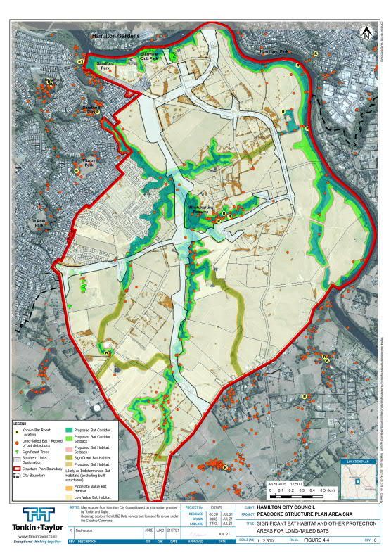
Document Control

 Title: Peacocke Structure Plan Area: Ecological Significance Assessment
 Date           Version   Description                     Prepared by:     Reviewed     Authorised
                                                                           by:          by:
 8/11/2019      1         Draft                           G Kessels        M Baber      P Cochrane
                                                          G Cummings
 12/03/20       2         Draft                           G Kessels        M Baber      P. Cochrane
 21/06/21       3         Draft                           G Kessels        M Baber      P Cochrane
                                                          M Baber
 21/07/21       4         Final                           G Kessels        G Cummings   P Cochrane
                                                          M Baber

Distribution:
Hamilton City Council                                                    1 PDF copy
Tonkin & Taylor Ltd (FILE)                                               1 PDF copy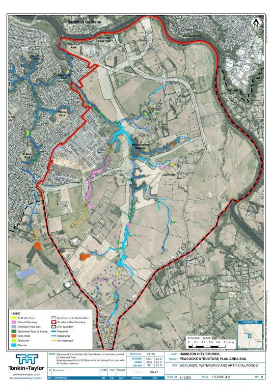
Table of contents

1        Introduction                                                                                  3
         1.1 Background and context                                                                    3
         1.2 Report purpose and scope                                                                  6
2        Methodology                                                                                   6
         2.1 Background                                                                                6
         2.2 Determination of candidate sites                                                          6
         2.3 Candidate site assessments                                                                7
         2.4 Significance assessment and relative level of significance                                7
         2.5 Qualifying Threshold Criteria relevant to PSPA                                            9
               2.5.1     Determining significant habitats for nationally at-risk, threatened species, or
                         regionally rare species (Criterion 3)                                         9
               2.5.2     Determination of under-representation (Criterion 4)                         10
               2.5.3     Determination of significant wetland habitat (Criterion 6)                  10
               2.5.4     Determination of aquatic habitat that is critical to an indigenous species
                         (Criterion 8)                                                               11
               2.5.5     Determination of habitat that provides ecological corridors or buffers
                         (Criterion 11)                                                              11
         2.6 Assignment of significance categories for each candidate site                           11
         2.7 Confidence levels                                                                       12
3        Ecological Context                                                                          12
         3.1 Indigenous Vegetation Communities                                                       12
         3.2 Nationally Threatened Land Environments                                                 13
4        Ecological Significance Assessment                                                          15
         4.1 Extent of ecologically significant areas                                                15
         4.2 Terrestrial Indigenous Plant Communities                                                20
         4.3 Significant vascular plant species                                                      20
         4.4 Ecologically significant wetlands & habitats of freshwater indigenous fauna             20
         4.5 Ecologically significant habitat for indigenous fauna                                   24
               4.5.1     Invertebrates                                                               24
               4.5.2     Fish                                                                        24
               4.5.3     Lizards                                                                     24
               4.5.4     Birds                                                                       25
               4.5.5     Long-tailed bat habitats                                                    25
               4.5.6     Protection of long-tailed bat habitat                                       28
5        Conclusion & recommendations                                                                30
6        Applicability                                                                               31
7        References & Bibliography                                                                   32
Appendix A :                      Key Source Literature & Databases
Appendix B :                      Confidence Level Definitions
Appendix C :                      Nationally At Risk and Threatened Species Lists

Tonkin & Taylor Ltd                                                                                    June 2021
Peacocke Structure Plan Area: Ecological Significance Assessment                         Job No: 1007479.0040.v4
Hamilton City Councill
1
Executive summary
Tonkin & Taylor Ltd (T+T) has been engaged by Hamilton City Council (HCC) to undertake an
assessment of significance of indigenous biodiversity within the Peacocke Structure Plan Area (PSPA)
against the criteria for determining significance of indigenous biodiversity set out in Section 11A of
the Waikato Regional Policy Statement (WRPS).
The assessment will assist the plan change process to support a land use change from rural and
semirural to intensive residential and commercial uses in the PSPA. This assessment is informed in
part by the PSPA bat report (Mueller et al. 2021). Collectively, the assessment and bat report
contribute to the PSPA Biodiversity Management Framework (Baber and Kessels, 2021), which seeks
to assist with achieving No Net Loss outcomes for indigenous biodiversity values across the PSPA and
surrounding landscape.
In 2012 HCC identified several significant natural areas (SNAs) within the PSPA based primarily on
the presence of significant indigenous vegetation (Cornes et al., 2012). However, we understand that
the 2012 study did not assess potentially significant habitats for indigenous fauna or all wetlands.
Ecological surveys indicate that a number of animals listed as nationally ‘At Risk’ or ‘Threatened’,
notably the ‘Nationally Critical’ long-tailed bat, use a range of habitats in the PSPA as part of their
habitat requirements. This habitat can include exotic vegetation such as willows or exotic pine
species in gully, wetland, shelter belt, stream or river edge habitat. Indigenous animals, particularly
long-tailed bat, can rely on such exotic habitats as essential components of their life cycles, for
breeding, moving through the landscape between core habitats, since indigenous vegetation is so
depleted within this landscape. This exotic habitat will therefore be used even if it is of marginal
quality. The WRPS ecological significance criteria do not differentiate between indigenous and exotic
plants as habitat for these native animals.
To assess significance of indigenous biodiversity in the PSPA, we:
Conducted a desktop review of all available information within the PSPA and immediate
surrounds, including recent bat studies in the locality, along with a review of up-to-date aerial
imagery; and
Assessed the proposed sites against the WRPS ecological significance criteria for each site,
along with maps and associated data shapefiles identifying those sites.
The Mangakōtukutuku Gully and Waikato River margin areas comprise a mixture of indigenous and
exotic vegetation. These areas provide important habitat for the nationally threatened long-tailed
bat and many indigenous bird and fish species. Consequently, a number of areas of indigenous
vegetation or habitats within the PSPA have been identified in this assessment as significant habitat
for indigenous biodiversity. This includes areas that provide existing habitat for indigenous fauna and
areas that are critical for protecting the long-term viability of such through the maintenance of
ecologically connectivity, i.e., ecological corridors.
Key findings associated with this ecological significance assessment are that:
1 The analysis has identified an increase in extent of ecologically significant habitats compared
to those identified as SNAs in the operative District Plan. These areas now collectively include
habitats of significant indigenous fauna, as well as significant indigenous vegetation and
wetlands.
2 Areas identified as ecologically significant include those that currently provide significant
indigenous vegetation or habitat for significant indigenous fauna, and areas considered critical
to the long-term persistence of these significant habitats through buffering and/or the
maintenance of ecologically connectivity in the landscape (particularly for long-tailed bats).
Tonkin & Taylor Ltd July 2021
Peacocke Structure Plan Area: Ecological Significance Assessment Job No: 1007479.0040.v4
Hamilton City Council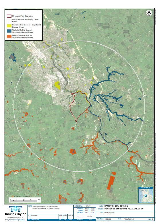
2

3        Ecological knowledge of the PSPA is incomplete. Planning mechanisms need to acknowledge
         and account for incomplete scientific knowledge and incorporation of new information which
         may alter the results of the ecological significance analysis presented in this report.

Tonkin & Taylor Ltd                                                                               July 2021
Peacocke Structure Plan Area: Ecological Significance Assessment                    Job No: 1007479.0040.v4
Hamilton City Council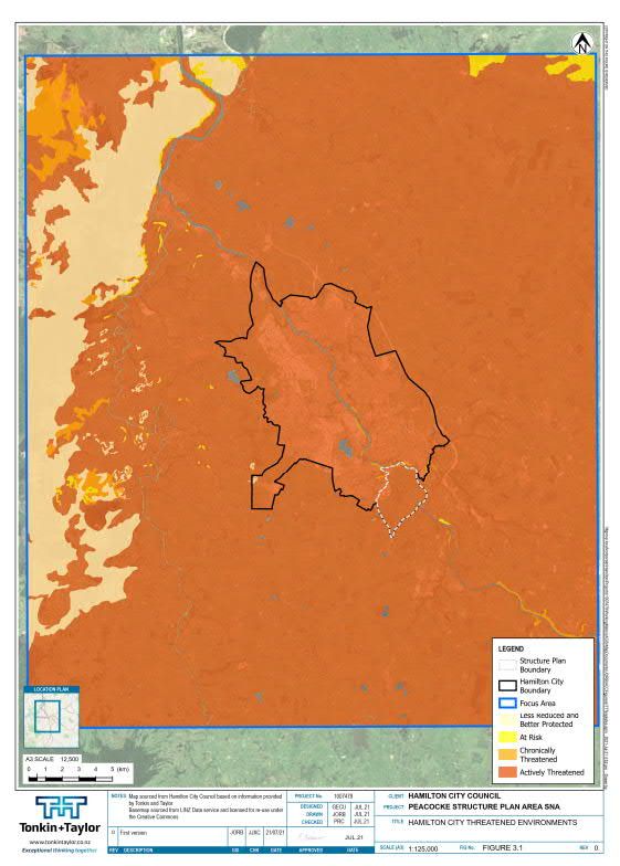
3
1 Introduction
1.1 Background and context
Tonkin & Taylor Ltd (T+T) has been engaged by Hamilton City Council (HCC) to undertake an
assessment of significance for indigenous biodiversity within the Peacocke Structure Plan Area
(PSPA). The assessment will provide technical information for the plan change process to support a
land use change from rural and semirural to intensive residential and commercial uses in the PSPA.
The assessment is informed by the PSPA bat report (Mueller et al., 2021) and other literature and
databases relating to indigenous biodiversity values in the PSPA area and immediate surrounds. In
turn, these documents contribute to the PSPA Biodiversity Management Framework (Baber &
Kessels, 2021), which seeks to assist with intended No Net Loss objectives for indigenous biodiversity
values across the PSPA and surrounding landscape.
The PSPA comprises approximately 750 ha of rural land on the southern fringe of Hamilton and was
initially zoned in 2007 to provide a framework for guiding urban development (Figure 1.1). The
Peacocke Structure Plan (PSP) was originally developed in 2009 to provide a framework for guiding
development within the PSPA. The PSPA is Hamilton City’s primary growth area and when fully
developed, is likely to accommodate up to 7,500 homes.
HCC is currently reviewing the PSP to address changes in the infrastructure needs of the city in this
locality and to accommodate changes in the policy framework to which the PSP must adhere. This
framework includes a requirement to protect areas of significant indigenous vegetation and
significant habitats of indigenous fauna (section 6(c) Resource Management Act 1991) in accordance
with the criteria for determining significance of indigenous biodiversity set out in Section 11A (Table
11-1) of the Waikato Regional Policy Statement (WRPS) (herein ‘WRPS criteria’). These criteria are
set out in Table 2.1.
We understand the structure plan process will then consider the further protection or management
of areas assessed as being ecologically significant as part of this analysis (over and above land
already set aside for amenity or conservation purposes, such as esplanade reserves and stormwater
wetlands, as well as other areas for urbanisation or infrastructure already consented). For example,
areas that will be used for roading and ecological mitigation associated with the Southern Links
designation have not been mapped in this assessment, but these areas will require coordinated
consideration during the plan change process.
The PSPA presently includes four Significant Natural Areas (SNAs) already identified in the Operative
Hamilton City District Plan:
SNA 56 is situated within the mid-lower section of the Peacocke’s Mangakōtukutuku sub-
catchment;
SNA 55 is situated within the Te Anau sub catchment; and
SNA 48 and SNA 54 are located within the Waikato River corridor.
Other SNAs have been identified by the Waikato Regional Council in neighbouring districts outside
the PSPA (Figure 1.1).
The existing SNAs were identified as having significant ecological character or value based primarily
on indigenous vegetation. However, the PSPA has yet to be assessed against the WRPS criteria
relating to significant habitat for fauna or for all wetland types.
The identification and protection of these areas of significant habitat for indigenous fauna is
particularly important for the long-term persistence of the nationally ‘Threatened’ long-tailed bat
(Chalinolobus tuberculatus) given that it has a threat status of ‘Nationally Critical’, i.e. the highest
possible threat category. Furthermore, because long-tailed bats are a highly mobile, wide-ranging
Tonkin & Taylor Ltd July 2021
Peacocke Structure Plan Area: Ecological Significance Assessment Job No: 1007479.0040.v4
Hamilton City Council
4

species and use a diversity of habitat types, this species also serves as an ‘umbrella species’ whereby
efforts to address effects on bats also serve to protect all or most other biodiversity values in the
landscape.
Figure 1.1 shows the current extent of SNAs within the HCC boundary (red), as well as within Waipa
District (orange) and Waikato District (yellow). The map indicates that SNA assessments in the
adjacent Waipa and Waikato districts include a number of gully, stream and river margins identified
as significant because of the significant indigenous fauna habitats they provide.

Tonkin & Taylor Ltd                                                                                 July 2021
Peacocke Structure Plan Area: Ecological Significance Assessment                      Job No: 1007479.0040.v4
Hamilton City Council
5

Figure 1.1: Previously mapped SNAs in relation to the PSPA.

Tonkin & Taylor Ltd                                                              July 2021
Peacocke Structure Plan Area: Ecological Significance Assessment   Job No: 1007479.0040.v4
Hamilton City Council
6
1.2 Report purpose and scope
This report provides an assessment of significance for indigenous biodiversity to inform HCC’s plan
change process for the PSPA. The report will assist HCC with policy and rule development as it
relates to Council’s obligations under section 6(c) of the Resource Management Act 1991 (RMA), and
associated policies and objectives of both the Operative Hamilton City District Plan and the Waikato
Regional Policy Statement (WRPS). This assessment contributes directly to the PSPA Biodiversity
Management Framework (Baber & Kessels, 2021), which seeks to assist with intended No Net Loss
objectives for indigenous biodiversity values across the PSPA and surrounding landscape.
For this assessment, this report presents the findings of:
A desktop review of available ecological information within the PSPA and immediate
surrounds along with a review of up-to-date aerial imagery to identify potential candidate
sites for further assessment; and
An assessment of the ecological values of each candidate site against the WRPS ecological
significance criteria (Table 2.1).
2 Methodology
2.1 Background
While the WRPS ecological significance criteria set out the ecological matters to be considered for
the determination of significance, a methodology, including ‘qualifying threshold criteria’, is required
to provide a robust and transparent framework for this assessment.
Previous SNA assessments for Waikato Regional Council (WRC) and other territorial authorities have
developed best practice which is appropriate for the Waikato region (e.g. Kessels et al, 2010; van der
Zwan & Kessels, 2017). WRC has also provided guidelines to allow interpretation of the WRPS
significance criteria. Specifically, in 2002, WRC produced guidelines to assist with the application of
assessment criteria and the determination of relative importance (or value) of each SNA (WRC and
Wildland Consultants, 2002). A recently updated version of these guidelines (WRC and Wildland
Consultants, in prep.) has also been used to assist in the determination of ecological significance and
relative importance of ecologically significant areas for this study. While these guidelines have no
legal status, they are helpful in the assessment of ecological significance as applied in this instance.
In addition, the draft National Policy Statement on Indigenous Biodiversity (NPS-IB, 2019) was also
used to inform the determination of thresholds for ecological significance within the PSPA.
2.2 Determination of candidate sites
Available literature, databases and maps were reviewed to identify candidate sites for subsequent
assessment of ecological significance (i.e. potentially significant sites). A list of key information
sources used for this literature review is provided in Appendix A. GIS shapefile data of the previously
mapped HCC SNA sites and orthorectified aerial imagery of the PSPA was provided by WRC.
A series of spatial datasets were overlaid on the PSPA to provide a combined dataset. Vegetation
coverage was established using three key tools: orthorectified aerial photography, Land Information
New Zealand (LINZ) topographic spatial data and the draft WRC Biodiversity Validation dataset
(BIOVEG, 2017), to establish preliminary polygon boundaries. In addition, all vegetation (exotic and
indigenous) was differentiated by spatial analysis using Aerial Photography, ArcGIS, and google earth
imagery.
Normalised Difference Vegetation Index raster generation was used to obtain a vegetation mapping
layer for the PSPA. Definitions and examples of vegetation/habitat structural classes and broad
Tonkin & Taylor Ltd July 2021
Peacocke Structure Plan Area: Ecological Significance Assessment Job No: 1007479.0040.v4
Hamilton City Council7
vegetation types are as defined in Atkinson (1985). Indigenous vegetation type classifications were
classified based on Singers and Rogers (2014), where applicable.
For the purposes of this project the minimum mapping unit was 0.05 ha (500 m2) per individual
polygon, rounded to the nearest 0.01 ha (100 m2). Areas of indigenous vegetation or habitats smaller
than 0.05 ha were not mapped or assessed unless such areas were determined to have a significance
level of at least "Regional" (see Section 2.4).
2.3 Candidate site assessments
The information on each candidate site was then collated to inform the subsequent assessment of
ecological significance.
Attribute data for each candidate site were presented in the form of an Excel spreadsheet to collate
site description and significance assessment information. This spreadsheet (hereafter referred to as
the ‘Master dataset’) included the following information to inform the assessment of each site:
Site name and number;
Protection status;
Land Environments classification;
Pre-European vegetation cover, recent vegetation cover and vegetation history;
Ecological District Bioclimatic Zone;
Aerial map and oblique photography review;
Area (ha) and mid-point grid reference;
Where available, source literature references for ecological information;
Nationally ‘Threatened’ and/or ‘At-risk’, or regional rare or endemic fauna and flora known or
likely to be present within the area assessed as ecologically significant;
WRPS significance criteria met or likely to be met;
Other distinctive features;
Relative significance (i.e. either international, national, regional, local or ‘not significant’) and
level of confidence (see section 2.6 below); and
Explanation/justification.
The methodology used for each key stage, including assessment of each candidate site against the
WRPS significance criteria (Table 2.1), is described in more detail in the sections below.
2.4 Significance assessment and relative level of significance
In determining whether a site is significant in terms of section 6(c), ecologists apply a set of criteria
in conjunction with professional judgement. The following section outlines the approach used when
determining a suitable qualifying threshold for ecological significance of candidate sites within the
PSPA.
Each candidate site was assessed to determine its significance in relation to Section 6(c) of the RMA
and to assign a relative level of significance in a Waikato region context. Relevant attributes were
completed in the Master Dataset.
To determine whether a candidate site was significant, the following 11 criteria defined in Section
11A of the WRPS were used to identify areas of significant indigenous biodiversity and their
characteristics as they existed when the criteria were applied.
Tonkin & Taylor Ltd July 2021
Peacocke Structure Plan Area: Ecological Significance Assessment Job No: 1007479.0040.v4
Hamilton City Council8
Criteria may be specific to a habitat type including water, land or airspace or be more inclusive to
address connectivity, or movement of species across habitat types.
A site was considered significant if at least one of the criteria were met.
Table 2.1: Criteria for determining significance of indigenous biodiversity Waikato Regional
Policy Statement (Table 11-1 WRPS)
Criteria
1 It is indigenous vegetation or habitat for indigenous fauna that is currently, or is recommended to be,
set aside by statute or covenant or by the Nature Heritage Fund, or Ngā Whenua Rāhui committees,
or the Queen Elizabeth the Second National Trust Board of Directors, specifically for the protection of
biodiversity, and meets at least one of criteria 3-11.
2 In the Coastal Marine Area, it is indigenous vegetation or habitat for indigenous fauna that has
reduced in extent or degraded due to historic or present anthropogenic activity to a level where the
ecological sustainability of the ecosystem is threatened.
3 It is vegetation or habitat for indigenous species or associations of indigenous species that are:
classed as threatened or at risk, or
endemic to the Waikato region, or
at the limit of their natural range.
4 It is indigenous vegetation, habitat or ecosystem type that is under-represented (20% or less of its
known or likely original extent remaining) in an Ecological District, or Ecological Region, or nationally.
5 It is indigenous vegetation or habitat that is, and prior to human settlement was, nationally
uncommon such as geothermal, chenier plain, or karst ecosystems, hydrothermal vents or cold
seeps.
6 It is wetland habitat for indigenous plant communities and/or indigenous fauna communities
(excluding exotic rush/pasture communities) that has not been created and subsequently maintained
for or in connection with:
Waste treatment;
Wastewater renovation;
Hydro-electric power lakes (excluding Lake Taupō);
Water storage for irrigation; or
Water supply storage;
unless in those instances they meet the criteria in Whaley et al. (1995).
7 It is an area of indigenous vegetation or naturally occurring habitat that is large relative to other
examples in the Waikato region of similar habitat types, and which contains all or almost all
indigenous species typical of that habitat type. Note this criterion is not intended to select the largest
example only in the Waikato region of any habitat type.
8 It is aquatic habitat (excluding artificial water bodies, except for those created for the maintenance
and enhancement of biodiversity or as mitigation as part of a consented activity) that is within a
stream, river, lake, groundwater system, wetland, intertidal mudflat or estuary, or any other part of
the coastal marine area and their margins, that is critical to the self-sustainability of an indigenous
species within a catchment of the Waikato region, or within the coastal marine area. In this context
“critical” means essential for a specific component of the life cycle and includes breeding and
spawning grounds, juvenile nursery areas, important feeding areas and migratory and dispersal
pathways of an indigenous species. This includes areas that maintain connectivity between habitats.
Tonkin & Taylor Ltd July 2021
Peacocke Structure Plan Area: Ecological Significance Assessment Job No: 1007479.0040.v4
Hamilton City Council9
Criteria
9 It is an area of indigenous vegetation or habitat that is a healthy and representative example of its
type because:
its structure, composition, and ecological processes are largely intact; and
if protected from the adverse effects of plant and animal pests and of adjacent land and water
use (e.g. stock discharges, erosion, sediment disturbance), can maintain its ecological
sustainability over time.
10 It is an area of indigenous vegetation or habitat that forms part of an ecological sequence, that is
either not common in the Waikato region or an ecological district, or is an exceptional,
representative example of its type.
11 It is an area of indigenous vegetation or habitat for indigenous species (which habitat is either
naturally occurring or has been established as a mitigation measure) that forms, either on its own or
in combination with other similar areas, an ecological buffer, linkage or corridor and which is
necessary to protect any site identified as significant under criteria 1-10 from external adverse
effects.
Whaley et al. (1995) listed the following core ecological concepts which should be considered when
determining ecological significance across all of the relevant WRPS criteria listed above:
Representativeness: How representative is the area of the full range of ecological diversity in
the present natural landscape?;
Diversity and pattern: What is the diversity of the ecological units and pattern of vegetation
types represented?;
Rarity/special features: Presence of locally or nationally threatened species or ecosystems;
Naturalness/intactness: Extent of indigenous species and natural communities in the area;
Size and shape: Influence of size and shape of the area on ecological viability;
Inherent ecological viability/long-term sustainability: Will the features of the area maintain
themselves in the long-term?;
Buffering/surrounding landscape/connectivity: Extent to which an area is buffered from
modifying influences. Distance from modifying influences and other natural areas;
Fragility and threat: Threat process and agents, effects of proposed modification; and
Management input: Nature and scale/intervention necessary & restoration potential.
The application of these core concepts to determine qualifying thresholds for key WRPS criteria is
described in further detail below.
2.5 Qualifying Threshold Criteria relevant to PSPA
2.5.1 Determining significant habitats for nationally at-risk, threatened species, or
regionally rare species (Criterion 3)
Relevant species for the assessment of this vegetation or habitat include those that are ‘Threatened’
or ‘At Risk’ within the New Zealand Threat Classification System (Townsend et al. 2008) or those that
are regionally rare species in the Waikato Region (Overdyck, 2019). As part of the ecological
significance assessment process, past records of threatened indigenous fauna species were
reviewed. However, many species, such as NZ kākā and NZ falcon, are only occasional users of the
PSPA area as part of their vast home ranges; their occasional presence in highly modified habitat is
therefore not considered sufficient to assign WRPS criterion 3 and hence to assess an area as
ecologically significant.
Tonkin & Taylor Ltd July 2021
Peacocke Structure Plan Area: Ecological Significance Assessment Job No: 1007479.0040.v4
Hamilton City Council10 Other fauna species, such as the long-tailed bat, regularly use or are dependent on the PSPA throughout the year. Qualifying thresholds are required to determine which areas or habitats are significant and which are not, often on the basis of an incomplete understanding of the animals’ usage of this landscape (see below). Importantly, the significance of a habitat for ‘Threatened’ or ‘At Risk’ species is often heavily dependent on ecological context i.e., all else being equal, similar habitat types may differ markedly in their significance for ‘Threatened’ or ‘At-Risk’ species based on surrounding landuse dynamics and ecological connectivity. Mueller et al. (2021) has determined habitat for bats based on where bat home ranges and core areas were located, combined with known roost sites. Where data was lacking, mature exotic tree shelterbelts and stands likely to provide habitat were included, both within and adjacent to the PSPA. This dataset has been used to assist in the assessment of significant habitats for long-tailed bats within the PSPA. Some indigenous plant species which are otherwise common in the wider landscape or ecological region/district are listed as nationally ‘Threatened’ or ‘At Risk’ due to the threat posed by myrtle rust, which can infect species in the Myrtaceae family. The presence of these species alone will not necessarily trigger criterion 3 in this assessment. However, given the rarity of kānuka forest (and in fact any indigenous forest remnant) in the Hamilton ED, kānuka forest triggers criterion 4 because it is considered significant as an under-represented vegetation community type (rather than because of its ‘At-Risk’ status due to myrtle rust). 2.5.2 Determination of under-representation (Criterion 4) Criterion 4 of the WRPS significance criteria requires assessment of ecosystem types that are under- represented (20% or less of it is known or likely original extent remaining) in an Ecological District, Ecological Region, or nationally (Singers & Rogers 2014). 2.5.3 Determination of significant wetland habitat (Criterion 6) For the purpose of this assessment for the PSPA, criterion 6 of the WRPS significance criteria has been used to determine ecologically significant wetlands in relation to section 6c of the RMA. These wetlands include Riverine, Palustrine and Ephemeral Spring or Seep wetlands1. We determined what constitutes a significant wetland following the approach used by Whaley et al. (1995). Generally, wetlands were determined to be significant where it was apparent that indigenous wetland vegetation formed the predominant vegetation cover and/or it was known habitat for aquatic or wetland indigenous fauna species. Determination of wetland presence and extent requires implementation of the Ministry for the Environment (MfE) wetland delineation protocols (MfE, 2020). Additionally, determination of what constitutes a ‘natural wetland’ is defined by the National Policy Statement for Freshwater Management (NPS-FM). We consider not all ‘natural wetlands’ as defined by the NPS-FM are significant as assessed against criterion 6, which requires its own assessment. Determination of wetland presence, extent, and significance, in many instances cannot be verified or detected based on desktop analysis of aerial photography. Wetland determination would require specific field surveys to validate and/or improve certainty of this desk-top assessment. Also of key importance, we note that the National Environmental Standards Freshwater 2020 regulations may significantly constrain development in or near to wetlands regardless of wetland values. 1Wetland definitions are as defined by Johnson, P. & Gerbeaux, P. 2004. Wetland Types in New Zealand. Science & Research Unit, Science Technology and Information Services, Department of Conservation, Wellington Tonkin & Taylor Ltd July 2021 Peacocke Structure Plan Area: Ecological Significance Assessment Job No: 1007479.0040.v4 Hamilton City Council
11
2.5.4 Determination of aquatic habitat that is critical to an indigenous species
(Criterion 8)
Criterion 8 requires an assessment of aquatic habitat2 (excluding certain artificial water bodies,) that
is critical to the self-sustainability of an indigenous species within a catchment of the Waikato
Region, or within the coastal marine area. In this context ‘critical’ means essential for a specific
component of the life cycle and includes breeding and spawning grounds, juvenile nursery areas,
important feeding areas and migratory and dispersal pathways of an indigenous species. This
includes areas that maintain connectivity between habitats.
The application of this criterion in relation to the PSPA focussed on the aquatic habitats of
Mangakōtukutuku Gully Stream and the Waikato River, both of which provide critical habitat for the
life-cycles of a number of freshwater fish species (refer to section 4.5.2 for a summary of the fish
species found within waterways within or adjacent to the PSPA).
2.5.5 Determination of habitat that provides ecological corridors or buffers (Criterion
11)
Ecological buffers and corridors are required within the PSPA to protect ecologically significant
habitats for a number of indigenous fauna species, most importantly for long-tailed bats (Mueller et
al., 2021). The adverse effects of urbanisation associated with the PSPA are the primary trigger for
criterion 11 requiring consideration within the PSPA ecological significance assessment. With respect
to protecting significant habitat for long-tailed bats within the PSPA, the Mueller et al. (2021) report
recommends:
buffering of key habitat features (such as the Waikato River and Mangakōtukutuku Gully) to
protect these key habitats and to create foraging and commuting habitats; and
creating bespoke ‘bat’ corridors to link key bat habitats through urban areas and to also create
additional habitat.
2.6 Assignment of significance categories for each candidate site
For each criterion, each candidate site was assessed as either:
“Significant”, because there was sufficient evidence for the site to trigger at least one of the
11 WRPS significance assessment criteria (Table 11-1 – WRPS);
“Likely” to be significant where the information available indicated the site had a high
likelihood of meeting one or more of the 11 criteria, but where this needed to be verified with
more information, such as from field surveys;
“Indeterminate” where there was insufficient information to determine if the site could meet
any of the 11 criteria, or be classified in the “Likely” or “Not significant” categories. More
information is needed for these sites, preferably from a field survey if possible; or
“Not significant” where, based on the information available, it was certain that the site did not
meet any of the 11 criteria.
The assessment of each criterion followed Table 2.1 of “Guidelines for determining areas of
significant indigenous vegetation and habitats of indigenous fauna in the Waikato Region” (WRC and
Wildland Consultants, 2019 – in prep.). If a site was found to be significant, then it was further
assessed to determine a level of significance, i.e. “International”, “National”, “Regional”, or “Local”,
following Table 2.1 of these guidelines.
2‘Aquatic habitat’ in this context includes habitat within a stream, river, lake, groundwater system, wetland, intertidal
mudflat or estuary, or any other part of the coastal marine area and their margins.
Tonkin & Taylor Ltd July 2021
Peacocke Structure Plan Area: Ecological Significance Assessment Job No: 1007479.0040.v4
Hamilton City Council12
2.7 Confidence levels
Since this assessment was based on desktop information rather than on detailed investigations, it
was important to distinguish between those sites that were expected or likely to be assessed as
ecologically significant based on field investigations, versus those sites that were unlikely to be
significant. This distinction in categories recognises that this may change as further information
comes to light.
Confidence levels are applied to reflect the quality and quantity of information available for a given
site. For each area deemed to be ecologically significant, a confidence level is applied to each
criterion depending on the degree of information available. Assigned confidence levels are:
High – well-researched sites, where ecological information about the site is comprehensive,
reliable, applicable and/or recent, and site specific;
Medium - Ecological information about the site is relatively comprehensive, reliable, not
entirely applicable/ recent, and/or more likely to be general than site-specific, e.g. the
information applies to a larger tract of indigenous vegetation, of which the site is a relatively
small part; and
Low – sites with little available ecological information. Information is not comprehensive, is
unreliable, out-dated or general.
Sites with lower confidence levels, e.g. most sites on private land, are higher priority for field surveys
than those with higher confidence levels. The qualifying thresholds for confidence levels are defined
in Appendix B.
3 Ecological Context
3.1 Indigenous Vegetation Communities
The PSPA is situated within the Hamilton Ecological District (ED). Within this flat to gentle rolling hill
landscape, low mounds or ridges of alluvial plains emerge by moderately to well-drained alluvium
from the Hinuera formation which predominantly supported mixed conifer-broadleaf forest. In
shallow depressions or swales the alluvium has more silt and clay and the poorer drainage in these
soils created boggy areas that were dominated by kahikatea semi-swamp forests. In lower terraces
beside the Waikato River, the alluvium has more sand and gravel and is better drained. These well
drained areas suited totara-matai-kowhai forest types (Clarkson et al., 2007). Very few peat areas
are situated in the PSPA, but areas of poorly drained gley-soils, as well as the small areas of peat
historically hosted a range of vegetation types including submerged vegetation, swamp forest,
sedgelands, shrublands and restiad bogs (Clarkson et al., 2007).
As Cornes et al. (2012) states:
“Hamilton City, at 11,080 ha, makes up 7.0% of the 159,375 ha of Hamilton Ecological District
(ED). Hamilton ED is confined to the Hamilton Basin with some of the surrounding hills and
foothills included (McEwen, 1987). Leathwick et al. (1995) found less than 2% of natural
vegetation that once existed in the ecological district pre 1840s still remains. Wetlands and
conifer forests were the dominant ecosystems of Hamilton ED before human settlement
(Harding, 1997). These two ecosystems also suffered the highest percentage reduction through
anthropogenic activities. All past vegetation types are less than 2% cover within the district.”
Gullies are a feature of Hamilton City. It is estimated that these were formed about 15,000 years ago
through a process called ‘spring sapping’. As the Waikato River cut down into its banks, small
streams were exposed which eroded steep-sided troughs that eventually became Hamilton’s gully
system. Gullies have two main land units: the steep gully sides, and the gully floor. On the sides, soil
Tonkin & Taylor Ltd July 2021
Peacocke Structure Plan Area: Ecological Significance Assessment Job No: 1007479.0040.v4
Hamilton City Council13 material is well-drained, generally from the Hinuera formation and once supported totara-matai- kowhai forest. The gully floors are more poorly drained and were dominated by kahikatea-pukatea- swamp maire forest (Clarkson et al., 2007). These gully systems comprise the Mangaone, Mangaonua, Mangakōtukutuku and Mangaharakeke gullies in the proximity of the PSPA. The Mangakōtukutuku Stream gully complex traverses the western side of the PSPA. Vegetation in this gully is now dominated by exotic treeland and pastureland, with almost no indigenous vegetation remaining. Despite the large portion of exotic vegetation, the gully system provides important habitat for a range of indigenous fauna species. Evidence from soil core samples and pollen analysis suggests that historically, most of the PSPA was once covered in conifer-broadleaf forest (Newnham et al. 1989). On slightly elevated mounds and ridges rimu/tawa forest would have been typical, and kauri and hard beech forests would have been found in the northern extent of the Hamilton ED. In the PSPA, kahikatea semi-swamp forest would have been dominant in the wetter, low-lying areas). The well drained terraces adjacent to the Waikato River would once have sustained totara-matai-kowhai forest. 3.2 Nationally Threatened Land Environments Taking a wider national perspective on the importance of the remaining natural values within Hamilton City, Land Environments of New Zealand (LENZ) threat classification system can be used to show the scarcity of habitats left for maintaining biodiversity. LENZ is a surrogate for the likely past (pre-human) pattern of terrestrial ecosystems and their associated biodiversity. The LENZ classification system has been used to classify “National Priority 1” threatened environments (MfE, 2007a, 2007b): those with 20 percent or less remaining in indigenous cover. The maps of National Priority 1 show land environments with 20% or less remaining indigenous vegetation from a New Zealand wide perspective. These land environments have been deemed to be the most critically threatened and of highest priority for protection in New Zealand (Walker et al., 2015). Figure 3.1 shows that the vast majority of Hamilton City is categorised as ‘Acutely Threatened’- National Priority 1 and thus any significant habitats of indigenous flora and fauna in this category are the most threatened at a national level. Tonkin & Taylor Ltd July 2021 Peacocke Structure Plan Area: Ecological Significance Assessment Job No: 1007479.0040.v4 Hamilton City Council
14

Figure 3.1: National Priority 1 Threatened Environments within The Upper Waikato basin including Hamilton
City (after Kessels Ecology 2016 – expert evidence for development of the Hamilton City District Plan)

Tonkin & Taylor Ltd                                                                                      July 2021
Peacocke Structure Plan Area: Ecological Significance Assessment                           Job No: 1007479.0040.v4
Hamilton City Council
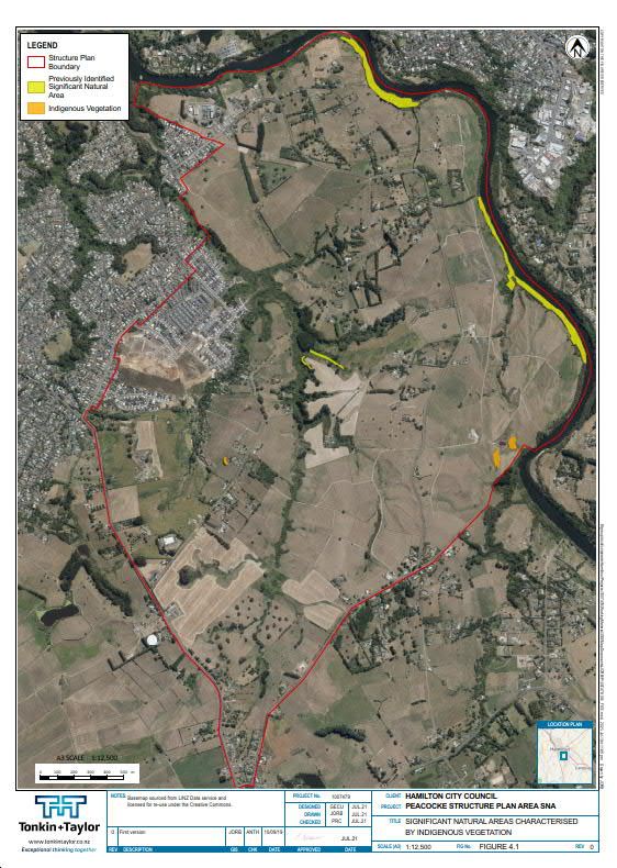
15

4                Ecological Significance Assessment

4.1              Extent of ecologically significant areas
A wide range of vegetation or habitats for indigenous fauna have been identified being ecologically
significant within the PSPA based on WRPS significance criteria. These significant ecological areas
have been assigned into ecological significance categories based on the ecological values they
provide.
Table 4.1 provides a summary of the various habitat types found within the PSPA including their
areal extent, key ecological attributes and which WRPS significance criteria they trigger.
Figure 4.1 and Figure 4.2 show the spatial distribution of these different ecological significance
categories over the PSPA. As discussed in Section 2, the original assessment of significance
undertaken for HCC focussed on indigenous vegetation habitats, and as Figure 4.1 shows, the SNAs
identified in that study (Cornes et al., 2012) covered a small portion of the PSPA. However, section
11A of the WRPS requires that habitat of significant indigenous fauna and wetland habitats is also
assessed, which has greatly increased the extent of identified ecologically significant areas within the
PSPA.

Tonkin & Taylor Ltd                                                                                  July 2021
Peacocke Structure Plan Area: Ecological Significance Assessment                       Job No: 1007479.0040.v4
Hamilton City Council
16

Table 4.1:         Key ecological features within the PSPA, their ecological significance, location relative to the development footprint and areal extent (a
                   considerable amount of this will be permanently lost due to southern links; refer to section 2.6 for definitions of significance categories).

 Key Ecological                General               Description                            Ecological characteristics and values            Key WRPS Ecological Significance
 Features and                  location                                                                                                      Criteria Triggered
 their aerial
 extent
 Ecologically significant areas of indigenous biodiversity
 Significant                   Mostly                This includes mostly exotic forest     These habitat types provides significant         Criterion 3: Long-tailed bats and ‘At
 indigenous                    outside the           and shrubland vegetation present       habitat for indigenous vegetation and fauna      Risk’ fish species have been
 terrestrial and               current               along the Waikato River,               present on site, and are particularly            confirmed to use these habitats.
 freshwater fauna              development           Mangakōtukutuku Gully and              important as roost, foraging and flyway          Criterion 4, criterion 6, criterion 8:
 habitat: Riparian             footprint             associated tributaries in the PSPA.    habitat for the ‘Threatened’ (nationally         Under-represented stream and
 margins and                                         There are areas of wetland and         critical) long-tailed bat and important for At   riparian margin habitat is utilised
 associated                                          stream habitats interspersed           Risk bird species including kākā, pied shag,     by a range of aquatic species.
 waterways (58.74                                    throughout. Most of this               little shag, little black shag, black shag and   Criterion 11: Parts of this habitat
 ha)                                                 vegetation is exotic though small      New Zealand dabchick. The waterways in this      provide an ecological buffer,
                                                     areas of habitat is dominated by       habitat complex also provide habitat for         linkage and corridors which are
                                                     indigenous vegetation in places        several ‘At Risk’ fish species, while the        necessary to protect significant
                                                     and exotic dominated vegetation        riparian margins enhance or protect the          habitat from external adverse
                                                     typically also includes native         waterway habitat. It may also provide habitat    effects.
                                                     species.                               for indigenous lizard species.
 Significant                   Mostly                This includes shelterbelts that        This is important foraging and flyway habitat    Criterion 3: Long-tailed bats have
 indigenous                    Inside the            provide connectivity across the        for long-tailed bats and indigenous bird         been confirmed to use, or likely to
 terrestrial fauna             current               landscape. The vegetation is largely   species.                                         use, these habitats.
 habitat: non-                 development           exotic.                                                                                 Criterion 11: This habitat provides
 riparian linear               footprint                                                                                                     an ecological buffer, linkage and
 features                                                                                                                                    corridors necessary to protect
 (ecological                                                                                                                                 significant habitat from external
 corridors) (20.49                                                                                                                           adverse effects.
 ha)
 Significant                   Mostly                This includes any vegetation,          This is foraging and flyway habitat for long-    Criterion 3: Long-tailed bats have
 indigenous bat                Inside the            including pasture, within 20 m of      tailed bat.                                      been confirmed to use, or likely to

Tonkin & Taylor Ltd                                                                                                        July 2021
Peacocke Structure Plan Area: Ecological Significance Assessment                                             Job No: 1007479.0040.v4
Hamilton City Council
17
Key Ecological General Description Ecological characteristics and values Key WRPS Ecological Significance
Features and location Criteria Triggered
their aerial
extent
habitat: non- current significant riparian margins and use, these habitats for foraging and
riparian habitat development associated waterways and as flyways.
ecological buffers footprint significant non-riparian linear Criterion 11: This habitat provides
(56.59 ha) features an ecological buffer, linkage and
corridors necessary to protect
significant habitat from external
adverse effects.
Significant Mostly This includes small fragments, This vegetation is important due to its rarity Criterion 4: These small indigenous
Indigenous outside groups or individual mature in the landscape, and provides important remnants are under-represented
vegetation development indigenous trees along the margins habitat for native flora and fauna as well as within the Hamilton Ecological
remnants (4.5 footprint of the Waikato River and native vegetation, and fauna present on site District.
ha*) associated tributaries in the PSPA. and is potentially important as roosting, Criterion 3: Long-tailed bats have
foraging and flyway habitat for the been confirmed to use, or likely to
‘Threatened’ (nationally critical) long-tailed use, these habitats
bat.
Ecologically Significant wetlands and wetlands where significance is Likely or Indeterminate
Wetlands (7.3 ha) Mostly The wetland areas comprise a Wetlands are threatened ecosystem types Significant. Some wetland areas are
including Riverine outside the mixture of exotic and native rushes and may include wetland associated Likely or Indeterminate until
& Palustrine development and sedges, sometimes with a ‘Threatened’ or ‘At Risk’ species and are further site-specific surveys are
wetlands (5.6 footprint, canopy of exotic deciduous trees, potentially important as roosting, foraging undertaken. Criterion 4, criterion
ha*) and but some and native tree ferns. and flyway habitat for ‘Threatened’ 6, criterion 8: Under-represented
Ephemeral Seep wetlands are (nationally critical) long tailed bat. wetlands and wetland habitat
or Spring within which is utilised by a range of
wetlands (1.7 ha). pasture aquatic and terrestrial indigenous
areas within species.
the
development
footprint
Tonkin & Taylor Ltd July 2021
Peacocke Structure Plan Area: Ecological Significance Assessment Job No: 1007479.0040.v4
Hamilton City Council18
Key Ecological General Description Ecological characteristics and values Key WRPS Ecological Significance
Features and location Criteria Triggered
their aerial
extent
Long-tailed bat habitats assessed as Indeterminate
Potential long- Mostly This includes shelterbelts or groups This is deemed to be potentially utilised for Significance status is Indeterminate
tailed bat habitat: Inside of trees that provide connectivity bat roosting, foraging or commuting based on until further site-specific surveys
Linear features or development across the landscape for long-tailed structural characteristics of the linear or are undertaken. Criterion 3: Long-
groups of trees footprint bats or roosting. The vegetation is groups of trees, but where survey data is tailed bats may use these habitats
non-riparian and largely exotic. inconclusive in terms of determining habitat but there is currently no evidence
non-buffer linear usage (Mueller et al. 2021). to validate usage.
features Criterion 11: These treescapes
(shelterbelts) could provide an ecological buffer,
(40.95 ha) linkage and corridors necessary to
protect significant habitat from
external adverse effects, but there
is no evidence at this point in time
to validate these ecological
functions.
Long-tailed bat habitats assessed as Indeterminate or Not Significant
Bat habitat: Mostly This includes open grassland, Where not directly adjacent to (further than Significance status Indeterminate
predominantly inside the scattered trees, houses, roads and 20 m from) identified bat habitats, pasture until further site-specific surveys
scattered trees, development other built structures that are > 20 areas are unlikely provide significant habitat are undertaken or Not Significant in
pasture grass and footprint m (Mueller et al. 2021) away from for long-tailed bats, noting that these habitats terms of build structures.
existing built any significant habitat types. may still be used sporadically for foraging or Much of these open pasture may
structures (561 Further survey is required to commuting. be used occasionally by indigenous
ha) validate the status of these areas fauna, but are not likely to provide
significant habitat for indigenous
long-tailed bats. However, further
studies may indicate that long-
tailed bats require specific parts of
these areas. Should further studies
identify regular usage of some
localities within the PSPA not
Tonkin & Taylor Ltd July 2021
Peacocke Structure Plan Area: Ecological Significance Assessment Job No: 1007479.0040.v4
Hamilton City Council19
Key Ecological General Description Ecological characteristics and values Key WRPS Ecological Significance
Features and location Criteria Triggered
their aerial
extent
identified as significant, then
criterion 3 and/or criterion 11 could
be triggered. Build areas are not
significant habitats for indigenous
fauna.
NB: *Existing SNA and some wetlands have been included in the sum total for riparian margins and associated waterways therefore the overall spatial extent of ecologically significant areas is
less than the sum of all significant areas
Tonkin & Taylor Ltd July 2021
Peacocke Structure Plan Area: Ecological Significance Assessment Job No: 1007479.0040.v4
Hamilton City Council20
4.2 Terrestrial Indigenous Plant Communities
Leathwick et al. (1995) calculated the decline in indigenous vegetation since 1840 and current
percentage cover. Since 1840, the Hamilton ED has had a 97.8% reduction in indigenous vegetation.
Percentage cover of indigenous vegetation in 1995 was about 1% forest and less than 1% scrub and
wetland for the entire Hamilton ED. Therefore, any structurally intact plant communities dominated
by indigenous vegetation within the PSPA are considered ecological significant in accordance with
criterion 4 of the WRPS significance criteria (“It is indigenous vegetation, habitat or ecosystem type
that is under-represented (20% or less of its known or likely original extent remaining) in an
Ecological District, or Ecological Region, or nationally”).
Within the PSPA only very small and scattered fragments of indigenous forest, shrubland and
wetland remain, all of which are secondary growth and modified to some extent. These SNAs were
identified and mapped by Cornes et al., (2012) as shown Figure 4.1 and have been included in the
Master Dataset as being ecologically significant.
4.3 Significant vascular plant species
Table C1, Appendix C, lists the nationally ‘At-Risk’ and ‘Threatened’ plant species found or likely to
be found within the PSPA.
Poroporo (Solanum aviculare var. aviculare), which is ‘Threatened – Nationally Vulnerable’ (de Lange
et al., 2018), has been recorded as being present in the vicinity of the PSPA. While this species could
potentially be present within the PSPA, it has not been recorded there.
Aside from this species, several species now classified as ‘Threatened’ due to the threat posed by
Myrtle rust are present and naturally occurring, in particular kānuka and mānuka. However, as
discussed in section 2.5.1 above, these species have been listed as ‘At-Risk’ due to the risk posed by
myrtle rust, and sites where these species are present are not considered to be significant habitat in
terms of the WRPS criteria on this basis alone. However, given its rarity in the Hamilton ED, kānuka
forest is considered ecologically significant and is one of the four sites mapped as an SNA by Cornes
et al. (2012; Figure 4.1) and is hence included in the Master Dataset.
4.4 Ecologically significant wetlands & habitats of freshwater indigenous
fauna
Wetlands, waterways and artificially created ponds have been mapped as shown on Figure 4.2.
However, it is key to note that the composition of wetland vegetation cover, especially for small
wetlands cannot be determined accurately through GIS desktop analysis. Many of the wetlands
mapped as artificially created areas, such as ‘detention ponds’, ‘culvert damming’ ‘farm pond’ or
aesthetic pond’ are unlikely to meet criterion 6 of the WRPS significance set (but could trigger other
criteria, such as criterion 3). Ground truthing is required to determine a more accurate
representation of ecologically significant wetlands within the PSPA.
For the purposes of this desktop assessment, all areas identified as Riverine, Palustrine, Ephemeral
Spring or Seep wetlands (as defined by Johnson & Gerbeaux 2004) are considered ecologically
significant, meeting criterion 6 of the WRPS criteria, and the specific areas have been assigned as
such in the Master Dataset.
As discussed in section 4.5.2, indigenous fish and freshwater invertebrates listed as nationally ‘At
Risk’ or ‘Threatened’ by the Department of Conservation use freshwater streams and wetland
habitats in the PSPA as part of their full life cycle requirements. Where this habitat is buffered by
well-vegetated riparian margins, often exotic, these areas are considered to trigger either criterion 3,
criterion 6, criterion 8 or criterion 11 of the WRPS significance criteria. These areas have been
Tonkin & Taylor Ltd July 2021
Peacocke Structure Plan Area: Ecological Significance Assessment Job No: 1007479.0040.v4
Hamilton City Council21 assigned as being significant, either being captured in the significant wetland layer or the significant bat habitat GIS layers, and have also been included in the Master Dataset. Tonkin & Taylor Ltd July 2021 Peacocke Structure Plan Area: Ecological Significance Assessment Job No: 1007479.0040.v4 Hamilton City Council
22

Figure 4.1: Existing mapped SNA and indigenous vegetation SNA within the Peacocke Structure Plan Area (as
identified by Cornes et al., 2012)

Tonkin & Taylor Ltd                                                                                     July 2021
Peacocke Structure Plan Area: Ecological Significance Assessment                          Job No: 1007479.0040.v4
Hamilton City Council
23

Figure 4.2: Wetlands found within the Peacocke Structure Plan Area

Tonkin & Taylor Ltd                                                                July 2021
Peacocke Structure Plan Area: Ecological Significance Assessment     Job No: 1007479.0040.v4
Hamilton City Council
24

4.5              Ecologically significant habitat for indigenous fauna
Within the PSPA, indigenous animals rely on exotic habitats as essential components of their life
cycles, for breeding or migration, or buffering waterways. Because indigenous vegetation is so
depleted within this landscape, this habitat is the only habitat available, even if it is of marginal
habitat quality and is very weedy. The WRPS significance criteria do not differentiate between
indigenous and exotic plants as habitat for these ‘At Risk’ and ‘Threatened’ animals.
As Wildlands & WRC (in prep.) state: “Areas of vegetation and habitats of indigenous fauna are not
static in the environment; they will change with natural processes, climatic changes, and as a result
of active management. Consequently the ecological values of a site can change over time and a site
which may previously have been assessed as Not Presently Significant may be assessed as Significant
or of Indeterminate Significance at a later date.”
Where habitat is shown to be regularly used by nationally ‘Threatened’ and ‘At Risk’ fauna, criterion
3 of the WRPS is met, making those areas ecologically significant. Appendix C contains tables which
list the nationally ‘Threatened’ and ‘At Risk’ fauna species recorded as being present, or likely to be
present, in the PSPA. The following sections provide a summary of the key indigenous fauna,
including nationally ‘At-Risk’ and ‘Threatened’ species, present or potentially present in the PSPA.

4.5.1            Invertebrates
Two terrestrial invertebrate species listed as regionally uncommon – Auckland tree weta and velvet
worm (Peripatus novaezelandiae) – may be present within forested vegetation (Overdyk et al.,
2019). Although they have not been recorded within the PSPA, they are found in the Hamilton
Ecological District and indigenous vegetation remnants in the gully areas may be suitable habitat for
these species.
In terms of freshwater invertebrates, kākahi – freshwater mussel (Echyridella menziesii) - At Risk –
Declining, and the freshwater snail – (Austropeplea tomentosa) – Data Deficient - have been
recorded within waterways in proximity to the PSPA and may be present in the Mangakōtukutuku
Gully Stream and the Waikato River.

4.5.2            Fish
The Hamilton Ecological District is home to a wide range of fish species as identified in Dunn et al.
(2018) and those species potentially found within the PSPA are summarised in Table C3, Appendix C.
The New Zealand Freshwater Fish Database (NZFFDB) indicates the presence of longfin eel (Anguilla
diefenbachii), lamprey (Geotria australis), īnanga (galaxias maculatus), giant kōkopu (Galaxias
argenteus), shortjaw kōkopu (Galaxias postvectis), torrentfish (Cheimarrichthys fosteri), redfin bully
(Gobiomorphus huttoni), koaro (Galaxias brevipinnis), and black mudfish (Neochanna diverus), all
classified as ‘At Risk’ or ‘Threatened’.
The presence of ‘At Risk’ or ‘Threatened’ indigenous fish within the streams and wetlands of the
PSPA triggers criterion 3, criterion 6 and criterion 8 of the WRPS ecological significance criteria.

4.5.3            Lizards
Three lizard species have been recorded in the locality (DOC BioWeb database). The most common
of these is the copper skink, (Oligosoma aeneum), which is widespread in the Waikato and not
threatened (Hitchmough et al., 2016). Faecal material attributed to forest gecko (Mokopirirakau
granulatus) has been reported in the Hakarimata Ranges, some 30 km to the north. DOC also has a

Tonkin & Taylor Ltd                                                                                    July 2021
Peacocke Structure Plan Area: Ecological Significance Assessment                         Job No: 1007479.0040.v4
Hamilton City Council
You can also read