Application of the Water-Energy-Food Nexus Approach to the Climate-Resilient Water Safety Plan of Leh Town, India - MDPI
←
→
Page content transcription
If your browser does not render page correctly, please read the page content below
sustainability

Article
Application of the Water–Energy–Food Nexus Approach to the
Climate-Resilient Water Safety Plan of Leh Town, India
Natalie Páez-Curtidor, Daphne Keilmann-Gondhalekar *                           and Jörg E. Drewes

                                          Chair of Urban Water Systems Engineering, Department of Civil and Environmental Engineering, Technical
                                          University of Munich, Am Coulombwall 3, 85748 Garching, Germany; natalie.paez@tum.de (N.P.-C.);
                                          jdrewes@tum.de (J.E.D.)
                                          * Correspondence: d.gondhalekar@tum.de

                                          Abstract: Climate-resilient water safety plans (CR-WSPs) have been developed as a risk-based
                                          approach to ensure a safe drinking-water supply while addressing the increasing stress on water
                                          resources resulting from climate change. Current examples of the application of CR-WSPs show a
                                          strong sectoral approach that fails to explore the potential synergies between other climate-sensitive
                                          sectors related to water, such as food and energy. This can increase the vulnerability or decrease the
                                          overall resilience of urban systems when planning climate change adaptation measures. In this work,
                                          the Water–Energy–Food (WEF) Nexus approach was applied in the formulation of a CR-WSP in Leh
                                          Town, India, a city with rapid development and population growth located in the Himalayas—one
                                          of the most sensitive ecosystems to climate change. The WEF Nexus approach was applied in the

                                   system description using a critical infrastructure approach and in the formulation of scenarios for
                                          risk management which exploited intersectoral synergies through water reclamation with resource
Citation: Páez-Curtidor, N.;
Keilmann-Gondhalekar, D.; Drewes,
                                          recovery using constructed wetlands. The improvements in WEF security and risk reduction were
J.E. Application of the Water–Energy–     demonstrated through indicators and risk mapping with geographical information systems (GISs).
Food Nexus Approach to the Climate-       The methods for integrating the WEF Nexus approach in CR-WSPs provided through this work can
Resilient Water Safety Plan of Leh        serve as a base for a trans-sectoral, resilient approach within risk-based approaches for water security.
Town, India. Sustainability 2021, 13,
10550. https://doi.org/10.3390/           Keywords: climate-resilient water safety plans; Water–Energy–Food Nexus; water security
su131910550

Academic Editors: Mohammad
Valipour, Vasileios Tzanakakis and        1. Introduction
Andreas N. Angelakis
                                               More than two billion people worldwide live in areas with high water stress [1].
                                          Population growth, the intensification of agriculture, urbanization, industrialization and
Received: 22 July 2021
Accepted: 17 September 2021
                                          the persisting water pollution will further increase the pressure on water resources [1].
Published: 23 September 2021
                                          As water in sufficient quantity and quality is crucial for life and development, ensur-
                                          ing water supply and sanitation has gained increasing attention in the global political
Publisher’s Note: MDPI stays neutral
                                          agenda and is embodied in the establishment of many of the Sustainable Development
with regard to jurisdictional claims in
                                          Goals (SDGs) [1]. In particular, cities experience specific challenges regarding water stress
published maps and institutional affil-   due to rapid population growth, growing water demands and an increasing provision
iations.                                  of food and energy which accompany economic development [2]. This can lead to an
                                          overexploitation of freshwater resources and, in many cases, to an increased dependency
                                          on imported water sources or on a single local source, which increases competition in
                                          water use between different sectors [2]. The fact that urban water systems depend on
Copyright: © 2021 by the authors.
                                          global, regional and watershed-scale pressures adds complexity and uncertainty to urban
Licensee MDPI, Basel, Switzerland.
                                          water security [2]. Furthermore, the risk of flooding in cities increases as impervious areas
This article is an open access article
                                          expand, and the rise in wastewater generation together with poor sanitation can adversely
distributed under the terms and           impact freshwater quality [2]. In developing cities, the existence of slums and poverty
conditions of the Creative Commons        with no proper water and sanitation infrastructure presents an additional challenge [2].
Attribution (CC BY) license (https://     Moreover, the changing patterns in the water cycle that derive from climate change can
creativecommons.org/licenses/by/          impact the occurrence of hazardous events, water availability and the water quality of
4.0/).                                    freshwater resources [2,3]. Climate change can also threaten the existing infrastructure for

Sustainability 2021, 13, 10550. https://doi.org/10.3390/su131910550                                  https://www.mdpi.com/journal/sustainability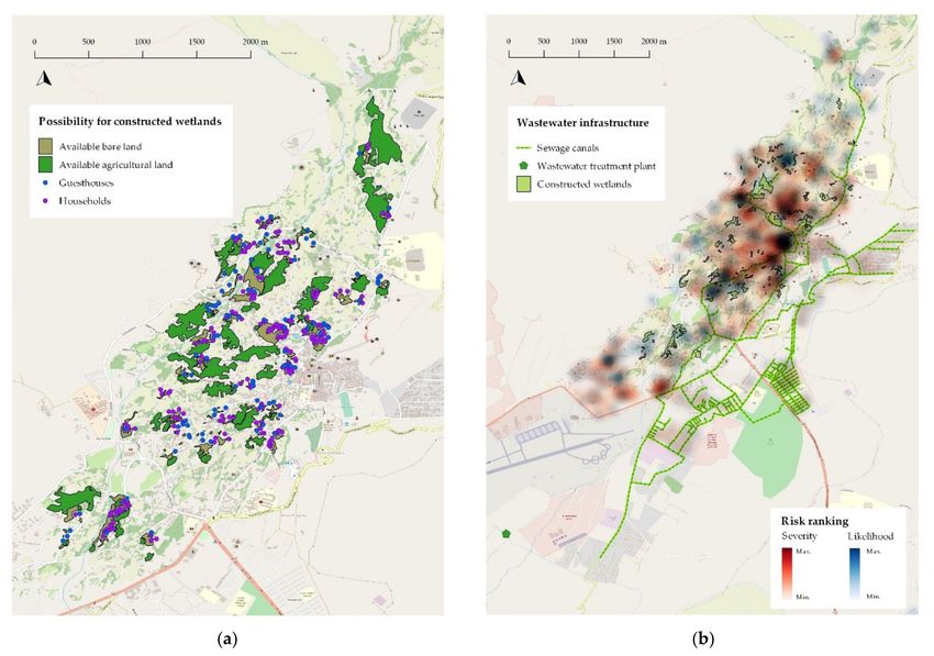
Sustainability 2021, 13, 10550                                                                                                2 of 29

                                 water provision and wastewater management, which has harsher impacts on communities
                                 with less capacity for preparedness due to mismanagement and rapid and unplanned
                                 urbanization [3]. The effects of climate change not only affect the urban water environment
                                 but also influence all social and ecological systems at various scales, thus conditioning the
                                 quality of life and economic competitiveness of cities [4].
                                       Within this context, achieving water security is a recognized priority and has been re-
                                 garded as the general aim of water management by various authors and institutions [2,5–7].
                                 Although there is no unique definition of water security, its most comprehensive interpreta-
                                 tion involves fulfilling all of the different water services for societies and ecosystems while
                                 also considering overall welfare, social equity and environmental sustainability [2,3,7].
                                 Thus, water security relates to the pillars of societal security itself [7]. In particular on a city
                                 level, urban water security involves applying the water security concept to a “territory of
                                 an urban area, municipality or urban agglomeration” [2]. The importance of approaching
                                 water security at the city scale lies in the distinct and inherent characteristics of urban
                                 areas that influence water stress. These include their high population density, their depen-
                                 dence on regional or global land for the supply of resources—including water, food and
                                 energy—and the high density of economic activities occurring within cities, which concen-
                                 trates water-related risks [2]. In addition, there are particular governance settings at the
                                 urban level that usually exist in different municipal departments for different water-related
                                 services or indirect water-relevant duties [2].
                                       Water security has been approached in the literature from four main foci, as con-
                                 cluded by Hoekstra et al. [2]: enhancement of economic welfare, increase of social equity,
                                 achievement of long-term sustainability or reduction of water-related risks. The risk-based
                                 approach implies managing hazards—such as natural disasters and water pollution—and
                                 reducing the vulnerability to extreme conditions arising from drivers such as climate
                                 change [2]. In urban areas, the exposure to hazards is relatively high derived from the
                                 concentration of people and assets, while vulnerability comes from improper adaptation,
                                 unpreparedness, low coping capacity and lack of measures for increasing resilience [2].
                                 As risk represents the potential for unwanted events to materialize, risk-based decision
                                 making uses evidence of risk to guide individual and societal choices regarding possible
                                 courses of action [8]. This approach has been preferred by some authors as they provided a
                                 “theoretic, empirical, and operational” basis for water security while allowing the quantifi-
                                 cation of the effectiveness of investments for addressing water-related risks [8]. The water
                                 safety plan (WSP) methodology developed by the World Health Organization (WHO) is an
                                 example of risk-based approaches for managing water-related hazards.
                                       The necessity for a complimentary, interdisciplinary approach that recognizes the
                                 linkages of water security with food and energy security has been addressed in various
                                 publications [2,6,7,9,10], as achieving water security requires sound coordination and
                                 collaboration between several stakeholders with competing needs [3]. The Water–Energy–
                                 Food (WEF) Nexus approach is an analytical framework and governance approach that
                                 acknowledges this relationship, proposes to identify synergies and trade-offs within the
                                 sectors and promotes collaboration between them [7,11,12]. This is relevant considering
                                 that water, energy and food share critical characteristics such as their increasing global
                                 demand, the billions of people that lack access to them, their character as global goods and
                                 their dependency on healthy ecosystems [3]. The advantages of the WEF Nexus approach
                                 lie in the identification of opportunities to increase resource efficiency and the increase in
                                 cooperation and policy coherence between the sectors [12]. At urban level, the importance
                                 of this approach is exemplified in the increased dependency of urban areas on external
                                 energy, water and food provision which extends the environmental footprint of cities on
                                 scales larger than their geographical limits [2]. Furthermore, large-scale water services—
                                 such as drinking-water supply and wastewater management—require a high amount of
                                 energy for conveyance and treatment [2]. Urban water management interventions such as
                                 ecosystem conservation and water reuse can therefore impact energy consumption and
                                 carbon emissions significantly [2].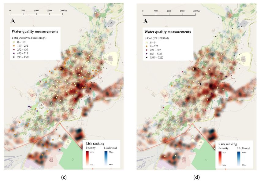
Sustainability 2021, 13, 10550                                                                                            3 of 29

                                      In the following sub-sections, the main characteristics, types and selected outcomes
                                 of current WSPs are discussed, as well as the importance of the WEF Nexus in climate
                                 adaptation and its possible implementation within the WSP framework.

                                 1.1. The Water Safety Plan Approach for Water Security
                                       A WSP is a recognized, well-established risk management approach designed to en-
                                 sure the safety of the drinking-water supply from catchment to consumers [13]. In a broad
                                 sense, WSPs aim to operationalize the framework for safe drinking water (FSDW), also
                                 established by the WHO, whose primary goal is to meet health-based targets in drinking
                                 water through a preventative approach [14]. To understand the relationship between the
                                 hazards and the processes in the drinking-water supply system and to establish preventive
                                 actions against hazardous events, WSPs are based on the hazard analysis and critical
                                 control points (HACCP) methodology. This involves analyzing hazards, identifying critical
                                 control points, establishing critical limits, monitoring, implementing corrective actions, doc-
                                 umentation and verification [14]. An additional important pillar of WSPs is the Stockholm
                                 Framework, which consists of an integrated risk management approach for controlling
                                 infectious water-related diseases [15]. Elements such as risk assessment, community in-
                                 volvement and the multiple-barrier principle have also been implemented in WSPs to
                                 prioritize risks and to lower the probability of failure through errors or omissions in the
                                 water supply [14]. The WSP methodology has been applied in about 90 countries, both
                                 in urban settings and rural communities [16]. Several potential benefits of implementing
                                 WSPs include the protection of public health, compliance with regulatory requirements, im-
                                 proved consumer and stakeholders trust, cost-effectiveness and investment planning [16].
                                 Some documented examples of improvements in water supply systems derived from WSP
                                 implementation include infrastructure upgrades, decreases in chemical and microbial pol-
                                 lution in water, and a better understanding of hazards and vulnerability against hazardous
                                 events, as in the case of Uganda [17] and Bangladesh [18]. An increase in water quality
                                 compliance was reported from case studies in Iceland [16,19], and policy development and
                                 investment in water quality information systems have been reported in South Africa [16,20].
                                 Cost reduction, improvement in management practices and integration of WSPs within
                                 public policies are other reported impacts of their implementation [16,17,21].
                                       In some countries, the WSP methodology has been adopted to the local context and
                                 has been integrated into existing water management programs, as in the case of the Pacific
                                 Islands, Ethiopia, the Democratic Republic of the Congo and India [16]. In particular,
                                 India has focused on the development of water security plans (WSePs) at state level to
                                 ensure that every individual in rural areas has enough safe water to meet their daily uses
                                 at all times [16,22]. The water management interventions have mainly addressed source
                                 management, water system management and water quality monitoring and surveillance,
                                 focusing on changing community behaviors through participatory approaches, obtaining
                                 external support for training, development of process guidelines, water quality monitoring
                                 procedures and infrastructure, infrastructure planning and funding allocation in water
                                 provision systems [16].
                                       As the primary focus of WSPs is to meet health-based targets for human health [15],
                                 some conceptual modifications of the methodology have arisen for enhancing its scope
                                 and addressing broader risks related to the urban water system [14]. Sanitation safety
                                 planning (SSP) was proposed by the WHO as a risk management approach for sanitation
                                 systems to ensure the achievement of health targets and addresses the risks related to
                                 wastewater treatment and reuse in agriculture [23]. This approach has been piloted in
                                 cities in India, Peru, the Philippines, Portugal, Uganda and Vietnam, where positive
                                 contributions to reducing water pollution and increasing safe water reuse have been
                                 observed since its implementation [23]. Water-cycle safety plans (WCSPs) enhance the
                                 WSP scope to the urban water cycle for the protection of public health, public safety and
                                 the environment, while considering climate change adaptation as the main driver for this
                                 integrated approach [15,24]. WCSPs acknowledge the aggravation of current conditions
Sustainability 2021, 13, 10550                                                                                           4 of 29

                                 and the emergence of new hazards arising from the impacts of climate change in the
                                 water cycle while pointing out that risk management requires an integrated approach
                                 and common work between society, utilities and other stakeholders [15]. WCSPs also
                                 acknowledge the dynamic character of the water cycle, which requires considering all of its
                                 components and interactions, thus incorporating wastewater management and reuse, as an
                                 extension to water supply [15]. This also considers resource efficiency and the minimization
                                 of greenhouse gas (GHG) emissions and acknowledges that water quality and quantity
                                 need to be addressed [15]. This approach was piloted in Lisbon, Eindhoven, Oslo and
                                 Simferopol as part of the UN PREPARED project [15].
                                       More recently, the climate-resilient water safety plan (CR-WSP) methodology has been
                                 developed by the WHO to address climate-related impacts on the water supply system in
                                 order to strengthen its resilience [24,25]. Although water suppliers already include climate-
                                 related events in planning—such as regular heavy rainfall or droughts—many of them
                                 have not addressed adaptation to future changes in climate in a systematic manner [25].
                                 Resilience can be defined as the “ability of a system to absorb changes of state variables,
                                 driving variables, and parameters, and still persist” [26,27]. In water management, this
                                 involves the capacity of maintaining services and supporting livelihoods when facing ex-
                                 treme events while incorporating long-term adaptation [26]. Thus, CR-WSPs highlight the
                                 need for adaptation to increasing flood risks and changes in the projected renewable water
                                 resources availability, which will intensify the competition for water between different
                                 sectors and will affect regional water, energy and food security [25]. The methodology also
                                 stresses the need for long-term planning, water demand and competition management,
                                 implementation of control measures to ensure water supply in suitable quality and quantity
                                 and improving operation and maintenance to ensure its effectiveness [25].
                                       For long-term resilience and supporting adaptation, CR-WSPs recommend the use of
                                 the IWRM principles for managing competing needs, increasing water use efficiency and
                                 handling trans-boundary water resources [25]. Many of the IWRM principles are linked to
                                 institutional and governance arrangements that directly or indirectly help to reduce risks to
                                 water supply systems [25]. At urban level, different approaches for implementing IWRM
                                 have been proposed, such as the Water Sensitive Urban Design in Brisbane, Melbourne
                                 and Sydney (Australia); the Sponge City in several cities in China including Beijing,
                                 Xiamen and Shenzhen; or the Sustainable Urban Drainage Systems in cities like Cambridge
                                 and Yorkshire (UK) [28–31]. All of these are motivated by the shared vision of shifting
                                 water management from the conventional paradigm of centralized, engineering-focused
                                 approaches toward more flexible and decentralized systems [30]. In addition, including
                                 non-conventional water resources and using innovative solutions for water reclamation
                                 with resource recovery are key elements of the application of IWRM in urban contexts [29].
                                 Some case examples of the application of CR-WSPs have been identified in several cities
                                 in Africa, Europe, South-East Asia and Western Pacific, most of them focusing on large
                                 urban water utilities [24]. The improvement measures proposed within CR-WSPs have
                                 included restrictions on land use, using nature-based solutions (NbS) such as reforestation
                                 with native tree species to protect the water table, using alternative water sources such as
                                 treated wastewater and flood resilience and attenuation measures [15,24,25].

                                 1.2. The Role of the Water–Energy–Food (WEF) Nexus in Climate Adaptation
                                       Water, energy and food are one of the most climate-vulnerable sectors [11]. At the
                                 same time, energy and food production have an important impact on the global green-
                                 house gas (GHG) emissions, which makes them influential sectors for climate change
                                 mitigation [11]. Since the WEF Nexus approach involves identifying crucial interactions,
                                 conflicting demands and potential synergies between WEF sectors, it can be a powerful
                                 way to achieve sustainable climate change adaptation [12]. Currently, actions for climate
                                 change adaptation have a development-oriented approach that is based on strengthening
                                 resilience to climate risks by considering the main causes of vulnerability rather than only
                                 responding to its effects [12]. This requires a trans-sectoral approach that is not limited to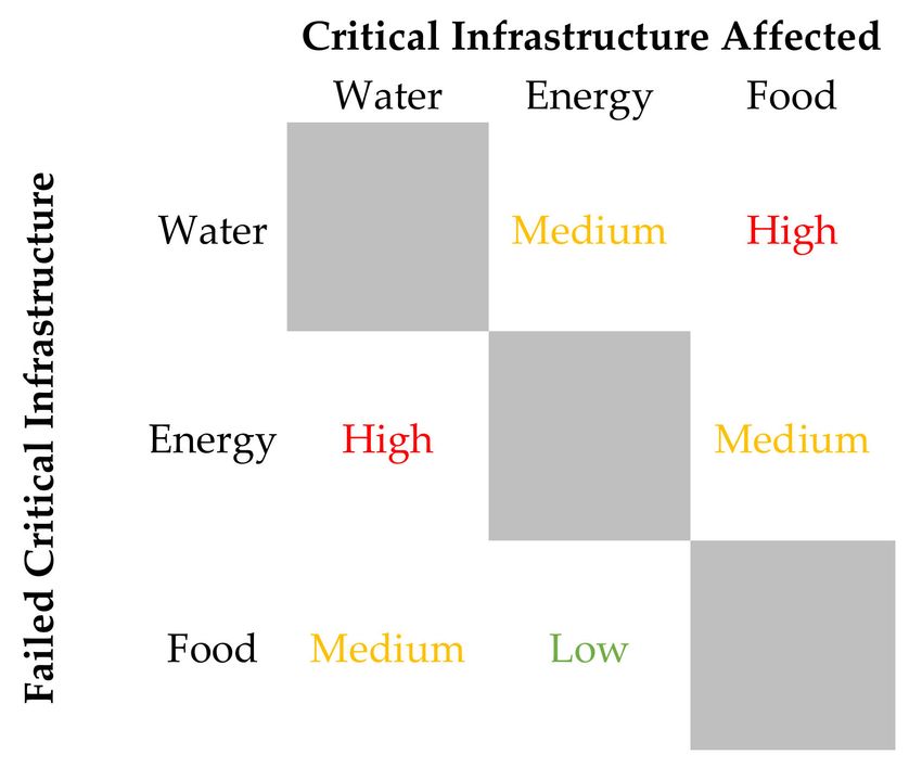
Sustainability 2021, 13, 10550                                                                                             5 of 29

                                 infrastructure-based solutions but extends to building response capacities and addressing
                                 the socioeconomic and institutional barriers that can also drive vulnerability [12].
                                      According to Rasul and Sharma [12], WEF Nexus approach-based adaptation aims to
                                 achieve security in WEF sectors through resource efficiency, intersectoral coordination and
                                 policy coherence, which ultimately reduces vulnerability [12]. The main elements of this
                                 approach involve minimizing resource waste while maximizing economic efficiency and
                                 encouraging sustainable supply, focusing on integrated solutions at multiple scales (local,
                                 national and regional) [12]. This approach is complimentary to IWRM in the sense that it
                                 expands the sectoral priority on achieving water security to equally important energy and
                                 food security [12]. Furthermore, systems thinking is inherent to the concept of resilience,
                                 as understanding the complex intersectoral relationships allows one to respond and adapt
                                 against risks [26].
                                      From this perspective, possible adaptation measures to manage intersectoral trade-
                                 offs can include increasing freshwater use efficiency, substituting freshwater use with
                                 alternative water resources such as treated wastewater, increasing resource recovery from
                                 wastewater, improving watershed management, increasing the use of renewable energy,
                                 improving the productivity of irrigation systems, promoting better crop, soil and nutri-
                                 ent management, rainwater harvesting, shifting consumer behaviors and reducing food
                                 waste [11]. Some of these measures overlap with those recommended within the IWRM
                                 framework and as such can be implemented within CR-WSPs as supporting programs and
                                 risk management procedures.

                                 1.3. Research Gaps and Hypotheses
                                       Although the need for an integrated approach is recognized in the CR-WSP frame-
                                 work, current examples of its application show a strong sectoral approach that fails to
                                 explore explicitly the potential synergies between other climate-sensitive sectors related
                                 to water, such as food and energy. This is exemplified in various country-level guidelines
                                 for (CR-)WSPs, where the energy and food sectors are only partially addressed in the
                                 system description and hazard identification, as in the example of the guidelines of the
                                 Netherlands [32], Ethiopia [33] and Nepal [34]. In the Indian WSP guidelines, the food and
                                 energy sectors are addressed as part of the water supply and irrigation infrastructure [22].
                                 However, the interconnections, synergies and trade-offs are, at least explicitly, left out of the
                                 analysis and risk management strategies. In general, WSPs are envisioned to be managed
                                 by the water supply providers, with external stakeholder collaboration limited to enabling
                                 the proper operation of water supply systems. In addition, most examples of improvements
                                 derived from the application of WSPs mostly report improvements on the water supply
                                 and compliance with water quality parameters [16]. Although this is beneficial for water
                                 security, important intersectoral dependencies and potential intersectoral benefits can be
                                 overlooked. This can increase the vulnerability or decrease the overall resilience of the
                                 system when planning adaptation measures [12].
                                       As the need for a more integrated approach within CR-WSPs is evidenced in the
                                 literature, this work aimed to address this gap by exploring the ways in which the Water–
                                 Energy–Food (WEF) Nexus approach can be applied to the formulation of a CR-WSP in
                                 Leh Town, India—a city with rapid development and population growth located in the
                                 Himalayas—one of the most sensitive ecosystems to climate change [35]. This work hy-
                                 pothesized that incorporating the WEF Nexus approach into the CR-WSP of Leh Town can
                                 contribute to the management of water-related risks while addressing synergies between
                                 food and energy for an enhanced WEF security in a climate change context. The town is
                                 located in a remote region with limited natural, financial and human resources and already
                                 faces several challenges regarding WEF security [12]. With an increasing population, a
                                 rapidly expanding tourism industry and a rising economy, Leh Town faces challenges
                                 for coping with an increasing WEF demand while also experiencing groundwater overex-
                                 traction and pollution from on-site sanitation facilities. Although water management at
                                 river-basin scale is one of the paradigms of the implementation of IWRM [36], the WEF
Sustainability 2021, 13, 10550 6 of 29
Nexus in CR-WSPs was evaluated at urban scale in this work. As WEF sectors are most
commonly managed within urban administrative boundaries, limiting the boundaries of
water security at city level enables a more direct operationalization of water security, as
pointed out in [37,38]. The following section provides an overview of the town and its
WEF sectors.
2. Case Study Site: Leh Town (Ladakh, India)
Leh Town is the capital of Ladakh, a region located in the Trans-Himalayas which was
declared as a Union Territory of India in 2019 (Figure 1) [39,40]. It is the administrative
and cultural center of Ladakh and is one of the towns with the most rapid growth in
the country [40]. With an average altitude of 3500 m above sea level, the town lies in a
remote, semi-arid area characterized by an average annual precipitation of 61 mm [41].
Precipitation and cloudbursts occur mostly during the monsoon period [35]. Leh has a cold
desert climate, with an average temperature that can reach −28 ◦ C in winter up to 35 ◦ C in
summer [35].
Figure 1. Geographical location of Leh Town, Ladakh, India.Sustainability 2021, 13, 10550 7 of 29
The Leh valley lies within the Ladakh Plutonic Complex [42,43]. From a geological
perspective, the study area is composed of granitoid, fluvio-glacial deposits and quaternary
sedimentary rocks [44]. A hard-rock fractured aquifer fed from precipitation and glacial-
and snowmelt constitute the main freshwater resource of the town [44]. Due to the presence
of high lineament density, high drainage density, lower slopes and the porosity of the
surface and subsurface in the center of Leh valley, the aquifer below Leh Town has a
high groundwater potential and serves as a groundwater accumulation zone [44]. The
groundwater flows from north to south following the terrain gradient and discharging into
the Indus River [42,45].
Leh Town used to have a traditional agricultural society [39]. However, tourism has
expanded rapidly since Ladakh was opened for visitors in the 1970s [39,44]. As most
of the tourists visit the region during the summer months (April through October), the
population of Leh Town has a high seasonal fluctuation. In 2018, it was estimated that about
35,807 people inhabited the town during the whole year, while the floating population
reached around 65,927 people, including tourists and seasonal migrant workers [44]. The
resident population in Leh Town has expanded exponentially since the 1990s, mostly
driven by the economic expansion created by tourism [39]. It is estimated that the fixed
population in the city will reach 43,000 people by 2021 and 55,000 people by 2031, showing
a vast difference compared with the 9897 inhabitants of the town in 1991 [39]. Ladakh is
also an important strategic region with an increasing regional presence of the Indian Army.
Daily, about 20,000 army personnel are stationed in Leh [39].
The local government, the Ladakh Autonomous Hill Development Council (LAHDC),
issued, in 2020, a vision document for 2030 [39] acknowledging the need to understand
and manage the challenges that the region has experienced since its opening to tourism.
Through a participatory multi-stakeholder process, several planning strategies were pro-
posed to address issues in mobility, water, sanitation, solid waste management, climate
change, heritage conservation, social infrastructure, spatial planning, urban design and
governance, based on a shared vision of wellbeing [39]. This demonstrates a high level
of awareness of the local government regarding the threats and opportunities that Leh
Town is facing confronted with rapid urbanization, economic change from agriculture to
the tourism sector, shifts in consumption patterns and climate change.
2.1. Consequences of Climate Change in Leh Town
Mountainous regions have high sensitivity to the impacts of climate change and
are exceptionally vulnerable to the amplified changes in temperature and precipitation
patterns resulting from it [35,46,47]. The climate of the Himalayan region is influenced by
the climate at global, regional and local levels and has a serious impact on the climatology,
hydrology and ecology of India [35]. A statistical analysis of the climate of Leh performed
in 2018 showed an overall increase in temperature and precipitation since the 1990s and
reported some indication of an increasing number of days with high precipitation in
the region over the years [35]. These results envision a further changing climate with a
higher probability of unexpected events, as well as impacts on ecology, vegetation, wildlife,
hydrology, cryosphere and agriculture in Leh [35].
Despite the typically dry climate, severe flash flooding events have been reported
in the region, as in the case of the 2010 flashfloods [48] which resulted in more than
a hundred deaths and several damages in Leh Town [39]. The damages included the
destruction of water-related infrastructure such as the man-made ponds (Zings) that have
an important role in water provision for agriculture [40]. Another flashflood in 2015
destroyed irrigation canals and fertile agricultural land while wiping out several crops,
livestock and households [49]. Water shortages, loss of local power generation and damage
in distribution networks were additional consequences of this event [49].
Although the occurrence of cloudbursts has not been extensively monitored in the
region, it has been estimated that about six additional flashfloods have happened in the Leh
district since 2005 [48], and there are signs of an increased frequency of these events over theSustainability 2021, 13, 10550 8 of 29
last decade [49]. The expansion of tourism, the rapid urbanization and the establishment of
infrastructure in flood-prone areas further increase the vulnerability of the region against
this hazard [49]. In addition, the observed increasing trend of precipitation and temperature
in the region further increases the vulnerability to extreme events and cloudbursts which
can have a critical impact in Leh [35].
The availability of groundwater and surface water depends on the glaciers located
north of Leh Town, namely the Phutse and the Nagste glaciers [50]. A study from 2017
that evaluated the change of high altitude glaciers in the Trans-Himalaya reported that the
area of the Phutse glacier decreased by 19% between 1969 and 2016 [50]. The area of the
Nagste glacier decreased by 14% during the same time period. Changes in glacier dynam-
ics directly affect the agriculture, livelihood and sustainability of meltwater-dependent
communities [50], such as Leh Town.
2.2. The Water Sector in Leh Town
The increased number of hotels and guesthouses derived from the expansion of
tourism has consequently increased the water demand and the pressure on the freshwater
resources of the region, particularly on groundwater [28]. As most of the touristic facilities
provide flushing toilets and showers, both the water consumption and wastewater pro-
duction have increased [36]. There is indeed a difference in water consumption between
different social groups in the town: while tourist and local residents consume around 100
and 75 l per capita per day (lpcd), migrant workers receive only 35 lpcd [35]. The estimated
domestic water demand in summer is about 5 million l per day (MLD) [51].
Traditionally, 90% of the water supply of Leh Town depended on surface water
streams fed from snowmelt, and the remaining 10% of the supply depended on springs [51].
Currently, surface water streams are no longer fit for drinking-water use due to direct
discharges of wastewater from commercial establishments and poor solid waste manage-
ment [40]. In addition, several springs have dried out, which citizens have linked with the
increasing groundwater extraction [40]. In fact, 90% of the currently provided domestic
water comes from groundwater resources, mostly from the shallow aquifer beneath the
town [51].
The public water supply is managed by the Public Health Engineering (PHE) depart-
ment, which supplies drinking water to the population through household taps, public
stand posts and water takers for some parts of the city [51]. About 1.5 MLD of water is
pumped from the riverbank of the Indus River to several reservoirs at different altitudes of
the town, with an overall capacity of about 7 MLD [51]. Inside Leh Town, about 1.3 MLD
of drinking water is extracted from tube wells and borewells [51]. An additional 0.8 MLD
of water is taken from several springs in the northern part of the town [51]. The water
infrastructure includes five tube wells on the riverbank of the Indus River (3 in operation),
16 storage reservoirs (12 in operation) and a piped water distribution system of about
93 km. Several handpumps are also used to pump water from the shallow aquifer in Leh
Town from a maximum depth of 10 m [52]. There are eight public water tankers that supply
water to about 2000 households where tap water connections are not available [51].
The tap water provided by the PHE department is only available for 2–3 h per day
and covers only 70% of the household water demand in the areas of the town with the
largest concentration of guesthouses and hotels [40]. The latest water audit report revealed
that water losses through the distribution system add up to 27% due to leakages [40].
The same report also mentions a domestic water supply deficit ranging from 1.67 to
5.09 MLD in summer. Several other issues have been identified in the water supply
system, including lack of or non-operating connections, poor or no pressure, irregular
supply timings, inconsistent water tanker supply, poor water quality and no volumetric
metering [40].
The perceived deficiencies in the public water supply, together with the changes in
water consumption behavior driven by tourism, population increase and economic growth,
have incentivized the installation of several private borewells for extracting water from theSustainability 2021, 13, 10550 9 of 29
shallow aquifer of the city [51]. It is estimated that 4000 borewells are currently installed in
Leh Town without any regulation on their pumping rates [40], which constitutes additional
stress on the groundwater resources.
There are ongoing plans to decommission public stand posts and installing tap water
connections for all households, as part of the Jal Jeevan Mission [40,51]. However, there are
concerns regarding its feasibility considering the winter conditions in Leh Town, where
extreme temperatures lead to frequent pipe freezing and bursting [51]. The water audit
also revealed that people are concerned about the increase in water consumption that
a 24 × 7 system would yield considering the falling groundwater levels and the glacier
reduction from climate change [40].
Adding to the concerns in the household water supply, there is no centralized or
unified wastewater management strategy in Leh Town [51]. For the most part, raw sewage
is currently disposed of using soak pits or leaking septic tanks without any treatment [41].
These on-site sanitation systems have replaced traditional dry sanitation practices—the
Ladakhi dry toilets—from which fecal matter was collected and composed to be used as
organic fertilizer [40,52]. Although the Ladakhi dry toilets are still used by the majority
of the local population, most of the tourists visiting Leh use flush toilets instead [52]. The
groundwater is therefore prone to contamination from these on-site sanitation systems, a
fact that has been studied and proven in some studies [40–42,53].
Groundwater pollution is a significant concern, as more than 90% of the drinking water
provided to the town depends on these resources [51]. Many private borewells are located at
less than 30 m from wastewater discharge points, which puts them at risk of contamination
by domestic wastewater [42]. Chloride, nitrate and total dissolved solids (TDS) are well-
known indicators of groundwater contamination linked to anthropogenic activities [42]. A
study from Schwaller [42] during the summer of 2017 revealed an increased, statistically
significant concentration of these parameters in 9 of the 11 wards of Leh Town with respect
to the groundwater in the north of Leh, where the population density is lower. In the same
study, the dominant source of these pollutants was identified as improper wastewater
management systems [42]. In addition, high concentrations of dissolved organic carbon
(DOC) were identified as downgradient of pit latrines, soak pits or leaking septic tanks.
The increased concentration of these pollution parameters coincides with the increased
density of households, guesthouses and hotels in these areas [42]. High pumping rates from
borewells create depression cones around the wells, which increases the risk of wastewater
seepage from on-site sanitation facilities into the deep groundwater [42]. This is shown
in the microbial contamination with E. coli identified in most of the deep groundwater
samples from the same study [42]. The prevalence of waterborne diseases is a concern in
Leh Town, as 64 cases were reported in 2018 [39].
To address these issues, the PHE department started the construction of a centralized
sewerage system and a sewage treatment plant in the south of Leh Town [39]. The system
is expected to cover 60% of the town with about 62 km of pipelines, with a wastewater
treatment capacity of 3 MLD using an aerated activated sludge system [39,54]. Although
this would mitigate groundwater contamination, concerns have been reported regarding
an overestimation of the population growth for the treatment design, the lack of local
experience for operation and maintenance of the system and the location of some parts
of the sewage pipes planned to run alongside freshwater provision pipes or areas with
high groundwater table [54]. The high volumes of water required for flushing the pipe
system and the high energy consumption of the treatment process are additional concerns
of the effectiveness and sustainability of the system [54]. The currently constructed sewage
lines already show problems in the connections, causing wastewater discharges into open
spaces [39].
The Municipal Committee of Leh Town commissioned, in 2017, a fecal sludge treat-
ment plant in the southern part of the town [39], which currently collects and treats about
12,000 L of wastewater per day from septic tanks around the town. This volume is in-
sufficient for the daily produced wastewater, which adds up to 4.2 MLD [39]. All of theSustainability 2021, 13, 10550 10 of 29
above-mentioned facts point out that it is imperative to seal existing septic tanks, stop the
construction of soak pits and open wastewater discharges and evaluate alternatives for
decentralized wastewater management systems that complement the planned centralized
system.
The first approach for developing a WSP for Leh Town was proposed in 2020 through
a collaboration between the Ladakh Ecological Development and Environmental Group
(LEDeG), a local non-governmental organization, and members of the Nexus@TUM group
(including the authors) at the Technical University of Munich (TUM). This work was
conducted within the “Livable Leh” project, whose main goal consisted of capacity building
for climate change adaptation [55]. The WSP points out that the greatest perceived risks
to the water supply of Leh Town are related to climate change (including changes in
glacial melt, changes in precipitation patterns and changes in water availability related to
these events), natural disasters (flashfloods), industries (tourism) and water management
practices (unregulated groundwater extraction with private borewells and use of soak pits
for sanitation).
2.3. The Energy Sector in Leh Town
Ladakh has a broad renewable energy potential. Hydropower is an important energy
source in the region with an installed capacity of 113 MW with plants such as the Nimoo
Bazgo (45 MW) and Chutak (44 MW) in the Indus River [56]. In early 2021, the construction
of eight additional hydropower projects in the Kargil and Leh districts with a total capacity
of 144 MW was cleared by the Indian government [56].
Leh also receives an important amount of daily solar radiation (about 5.5 kWh/m2 ),
which is higher than the average in India [57,58]. The potential for solar energy generation
is yet to be exploited and is gaining attention through the Ladakh Renewable Energy
Development Agency created by the LAHDC [59]. Within the Ladakh Renewable Energy
Initiative Project, several solar power plants have been constructed in the Leh District with
a total capacity of about 1.7 MW [59]. Currently, tender documents have been prepared
for the construction of photovoltaic water pumps in cooperation with communities and
farmers [59]. Several other projects for solar power harnessing have been implemented as
solar greenhouses, water heating systems and solar cookers [59].
As hydropower plants are difficult to operate in winter due to reduced flow stream,
thermal energy from diesel-operated plants is used as a backup [60]. Although diesel use
is expected to decrease after the connection of Ladakh to the Indian grid in 2019, several
sectors still use these fossil-fuel-based plants. For instance, every pump house in the water
extraction and conveyance scheme from the riverbanks of the Indus River has diesel backup
generators [60]. Some pump houses operate on these diesel generators as they are not
connected to the main electricity net [60]. In total, it has been estimated that the current
water supply in Leh emits about 658 t CO2-eq per year [58]. If fossil fuels are also used for
pumping through the private borewells, the GHG emissions are even higher. The planned
centralized approach for wastewater treatment, which has a high energy consumption
for the aeration process, has estimated emissions of almost 2 kg CO2-eq per cubic meter,
almost twice as high as the emissions from alternative decentralized wastewater treatment
approaches with constructed wetlands [58].
2.4. The Food Sector in Leh Town
Leh Town used to be self-sufficient regarding food production [60]. Small-scale
agriculture was a common practice for most families until recent times [39], where land-use
patterns have shifted from agriculture to tourism-related activities [52]. Currently, over
90% of the hotels and guesthouses are located in the agricultural wards of Leh Town, and
several agricultural lands have been either replaced by buildings or become barren [52].
The water management practices for agriculture have also changed significantly.
Historically, irrigation water was distributed and managed by Churpons, local leaders
elected by the Goba (headman of the village) [40]. Water used to be allocated through aSustainability 2021, 13, 10550 11 of 29
rotational system designed for an equitable surface water distribution depending on the
crops grown by each farmer [40]. Leh Town depended mostly on surface water available
from snowmelt, and about 18 springs, 3 major streams and 13 major ponds were available
for the community, for both household consumption and agriculture [40]. However, many
of the previously available springs have dried up, and various ponds have been destroyed
by natural disasters or left unused due to lack of management [40]. Although there are still
17 Churpons in Leh Town, this practice has decreased over the years, contributing to the
degradation of agricultural land and the increase of unmanaged bare land [40]. Currently,
farmers are increasingly depending on groundwater to irrigate their farms [39,40].
Despite the decrease in agricultural land, the variety of crops grown in the town has
expanded from five types of vegetables in the 1960s to more than 23 types for commercial
scale in Ladakh [39]. Broccoli, cabbage, cauliflower, peas, apricots, apples, melons, herbs
and medicinal plants are produced in Leh [39]. Pastoral farming is also prevalent in
the region [60]. While there is a recognized potential for larger food production within
Leh, challenges regarding the long and cold winters and the increasing water scarcity
call for implementing newer practices for crop growing and harvesting [39]. This is
gaining relevance as the dependency on food imports increases in Leh, which raises several
concerns for food security related to the risks of disruptions in the supply chain caused
by natural disasters (e.g., landslides), harsh winter weather conditions and global-scale
threats such as the COVID-19 pandemic [60]. The aim for increasing food self-sufficiency
and becoming an example of a town with water-sensitive, high-altitude urban farming
is one of the visions of the town [39], which can contribute to keeping a healthy diet and
being a source of local additional income [60].
3. Materials and Methods
The WEF Nexus approach was implemented into the CR-WSP of Leh Town in two
main parts. On the one hand, a critical infrastructure analysis of the WEF sectors was
conducted, intended to compliment the system description of the CR-WSP. On the other
hand, two scenarios for risk management that exploit intersectoral WEF synergies were
modeled for Leh Town. The scenarios included the implementation of water reclamation
with resource recovery using constructed wetlands, using GIS for risk visualization and
scenario analysis.
3.1. WEF Nexus Analysis of Leh Town with an Urban Critical Infrastructure Approach
The critical infrastructure (CI) approach proposed by [4] was used for identifying the
interlinkages within WEF sectors in Leh Town. For this goal, the main characteristics of
the CIs regarding the WEF sectors in Leh Town were analyzed, as well as their relation to
climate change risks. Then, the interrelationships between WEF sectors were summarized
in an interdependency matrix that categorizes the effects of one CI failure in another CI
into three categories: low, medium and high. Lastly, the potential implementation of this
information in the WSP of Leh was analyzed. The analysis was carried out with support
from the Ladakh Ecological Development and Environmental Group (LEDeG) during
several meetings and literature review.
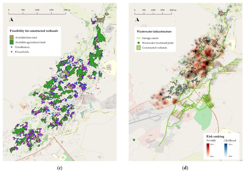
3.2. Mapping the Risk of Wastewater Seepage from On-Site Sanitation Systems
According to the risk assessment performed for the WSP of Leh Town, an important
hazard for its water resources is the seepage of untreated wastewater into the groundwater.
This hazard has been linked with the use of inadequate on-site sanitation facilities (i.e.,
soak pits, leaking septic tanks and disposal of wastewater in streams and canals). However,
the geographical distribution of this risk is not evident in the current WSP.
Geographic information systems (GISs) can be a valuable tool for implementing
various aspects of WSPs, as they can be used to visualize possible risks and water-related
information [61]. A semi-quantitative approach has been used previously for creating an
overview hazard and risk assessment [61,62], monitoring of control measures and incidentSustainability 2021, 13, 10550 12 of 29
management [62]. In this work, GIS was used for providing a visual representation of
the risk of wastewater seepage from on-site sanitation systems in Leh Town, with the
objective of identifying the places where groundwater pollution may be occurring at a
higher rate. The semi-quantitative risk mapping was also used for visualizing the impact
of the implementation of decentralized wastewater reclamation systems—a WEF Nexus
solution—using constructed wetlands for groups of hotels/guesthouses and households.
The maps were drawn using the OpenStreetMap base map of Leh Town [63] and the
software QGIS 2.18.21 (Las Palmas de Gran Canaria, Spain) [64].
The CR-WSP methodology defines the risk associated with a hazard or hazardous
event as the “combination of the likelihood of the hazard or hazardous event occurring
(over some time frame) and the severity of the consequences of the hazard or hazardous
event if and when it occurs” [25]. The parameters for the risk components were estimated
based on literature review and spatial analysis. The maps were designed to represent the
conditions of the wastewater seepage risk during the summer months, as this represents
the peak in population—and wastewater production—of the town. For risk mapping, the
severity was characterized as a function of the pollution load produced on-site that can
seep into the ground water. Therefore, this variable depended on the volume of wastewater
produced and its quality. The latter depends on the type of wastewater treatment applied.
Likelihood was characterized as a function of the number of on-site sanitation facilities
with a lateral distance lower than 30 m from borewells, as this increases the probability of
wastewater seepage into groundwater.
The parameters were calculated following the methods and assumptions listed in
Table 1. For the mapping, an existing spatial database from a survey previously conducted
by Gondhalekar et al. in 2015 [52] was used. The database included data with the location
and attributes of the PHE tube wells, the Indus River borewells, service reservoirs, hand-
pumps, water conveyance pipes, guesthouses/hotels and households. It also included the
future location of the planned centralized sewage treatment plant and canals, which will
service about 40% of the town [51].
After calculating the parameters, each dataset was reclassified into five groups for
obtaining a simplified ranking of the variables. As the data distribution of the wastewater
volume and the number of on-site sanitation facilities within 30 m of wells was skewed, the
Jenks natural breaks classification method [65] was used. This is a more suitable clustering
method in this case as it aims to reduce the variance within each class while maximizing
the variance between the classes, and thus the values are better arranged and classified for
mapping [65].
Table 1. Methods and assumptions for the calculation of parameters for the wastewater seepage risk.
Risk Component Parameter Method Assumptions
Differences in water consumption depending on
For hotels: multiplied the number
population sectors (tourists: 100 lpcd, locals: 75
of beds by the water consumption
lpcd and seasonal workers: 30 lpcd) [51].
of tourists. For households:
Wastewater volume Wastewater is 80% of water consumption.
multiplied the number of people
(m3 /d) Full occupation of hotels and guesthouses.
per household by the water
Wards of Skampari and Nimoling are mostly
consumption of locals or migrants,
inhabited by migrant workers [51].
depending on the ward.
Four people inhabit each household.
Calculated depending on the Wastewater generated from households,
Severity sanitation system in place, guesthouses and hotels has the same
considering the following characteristics as described in [66,69].
parameters: biochemical oxygen The removal efficiency from septic tanks was
demand (BOD), total suspended calculated based on [70].
Wastewater quality
solids (TSS), total nitrogen (TN) The removal efficiency of the planned centralized
(mg/L or CFU/100 mL)
and total coliforms (TC). These wastewater treatment system was calculated based
parameters were chosen as the on [71,72] (the latter for total coliforms only).
most relevant for designing The removal efficiency for the decentralized
decentralized sanitation systems wastewater treatment facilities using constructed
in Leh Town [54,66–68]. wetlands was based on [66].Sustainability 2021, 13, 10550 13 of 29
Table 1. Cont.
Risk Component Parameter Method Assumptions
A distance lower than 30 m between wells and
Created a buffer of 30 m around on-site sanitation facilities increases likelihood of
Number of each handpump, private borewell groundwater contamination [73].
Likelihood on-site sanitation facilities and PHE tube well. The number In total, 10% of the households and 60% of the
within 30 m of wells of on-site sanitation facilities guesthouses in the database were randomly
within this range was counted. selected and assumed to have a borewell,
following previous survey results [52].
For the case of the wastewater quality parameters, the clustering was performed
by dividing into five groups the range of pollutant concentration values within those of
untreated wastewater (maximum value) and those of treated wastewater intended for
Class A water reuse in irrigation as established by the European Union [74] (minimum
value). These guidelines were considered suitable for the clustering, as the proposed
WEF Nexus solution is envisioned to be applied for water reclamation in agriculture and
these guidelines are more stringent than those for treated wastewater for disposal into
watercourses. The results of the clustering are presented in Table 2. The 1-to-5 ranking for
each variable was used for creating a weighted heatmap. The water quality measurements
performed by Schwaller in 2017 [42] were mapped over the risk maps for the base case for
comparison.
Table 2. Parameter clustering and ranking for semi-quantitative spatial visualization of the wastewa-
ter seepage risk.
Wastewater Wastewater Quality (mg/L or Number of Wells 190 mg/L
TSS: >377.5 mg/L
5 >5.12 >9
TN: >37.5 mg/L
TC: >1.0 × 10⁷ CFU/100 mL
3.3. Implementing Scenarios for Constructed Wetland WEF Nexus Solutions for the CR-WSP
A major option for implementing a trans-sectoral approach that addresses the risks
in the water sector in Leh Town is water reuse with resource recovery. Water reuse,
or reclamation, refers to the treatment of wastewater with a defined process and water
quality criteria appropriate for an intended final purpose [75]. Water reuse reduces the
supply of freshwater resources, which implies savings in water treatment and conveyance,
preserves the current freshwater supply and reduces the discharges of wastewater [76].
In addition, water reuse is considered as a reliable water supply that is independent
of seasonal droughts and weather patterns, and it is able to cope with peaks of water
demand [76]. Due to these advantages, water reuse as an alternative water source is
included in current national and international water management strategies and its use
is considered as an indicator of increased urban water security [37,77]. As water reuseSustainability 2021, 13, 10550 14 of 29
widens the portfolio of available water resources, it adds flexibility against water stress,
which in turn increases resiliency [26].
For Leh Town, several alternatives for the implementation of decentralized water
reclamation systems using constructed wetlands (CWs) have been evaluated [54,66–68].
CWs are a type of nature-based treatment systems (NBTS) that mimic natural ecosystem
principles for water treatment. The efficiency of these systems depends mainly on the
complex interaction between soil, water, vegetation and the atmosphere, which leads
to achieving several treatment goals through mechanical, chemical and biological pro-
cesses [78,79]. CWs can achieve an appropriate treatment efficiency with relatively low cost
of earthwork, piping and construction [80]. As such, they have several advantages: design
simplicity, cost-effectiveness, high potential for nutrient recovery and water reuse [80]. An
additional advantage is that the main processes in these systems do not rely on external
energy resources [81], which increases the sustainability of the treatment as the demand
for fossil fuels can be reduced.
In particular, subsurface flow CWs (SSFCWs) have been identified as suitable systems
for the climatic conditions in Leh [66]. This type of CWs consists of a basin with an
impermeable barrier at the bottom and the sides to prevent seepage of wastewater and
groundwater contamination [81]. The basin is filled with porous media (such as sand, soil
or gravel) and local plants [81]. The wastewater flows under the surface of the porous
media, which minimizes the health risk of wildlife and people from exposure to untreated
wastewater [81]. As the water is not in contact with the atmosphere, these systems are
appropriate for a place like Leh, where the cold weather can hinder the treatment efficiency
of CWs. Suitable process configurations with constructed wetlands envisioned for water
reclamation with resource recovery have already been proposed for Leh Town in [66].
The implementation of CWs requires enough available area for the treatment processes.
In addition, as the effluent from the CWs is envisioned to be used for agriculture, enough
surrounding agricultural land for the treated wastewater is advantageous. Thus, feasible
locations for constructing these decentralized water reclamation systems were identified us-
ing the OpenStreetMap [63] vector feature classes obtained through the QuickMapServices
QGIS plugin. The land-cover layer “landuse = farmland” was downloaded to represent
the agricultural land. The land-cover layers “landuse = meadow”, “natural = wood” and
“natural = scrub” were downloaded for identifying the bare land available for the treatment
systems.
The possible available bare land was subsequently identified by defining a setback
distance between the treatment system locations and all households, guesthouses, wells,
rivers and reservoirs according to the guidelines defined in [82]. From this filtered bare
land layer, possible bare land areas that fulfilled the following criteria were selected:
they are within 50 m from each guesthouse/hotel and household, downstream from
these wastewater point sources (using available digital elevation model data and contour
lines) and do not cross paved roads or rivers. Then, the agricultural land nearby the
identified bare land for CWs was identified to evaluate the possibility of local irrigation
with reclaimed water.
The use of CWs for decentralized water reclamation in agriculture at town scale
was exemplified in two scenarios, which could both compliment the planned centralized
sewage collection and treatment system:
• Scenario 1: Here, a part of the town is connected to a centralized sanitation system
(households and guesthouses within 20 m of the sewage canals are assumed to be
serviced, as in [68]), and CWs are built for clusters of guesthouses and households.
The CWs for this case were designed for treating the wastewater generated during
summer (population peak) using the treatment train presented in Figure 2 [66]. This
scenario was the recommended treatment scheme in terms of treatment efficiency, cost
and appropriateness for weather and population fluctuations in Leh [66]:
• Scenario 2: Here, the conditions of scenario 1 are complemented by the implementation
of CWs for household clusters. The CWs for this case were designed for year-roundYou can also read