AQUATIC BIODIVERSITY IMPACT ASSESSMENT SCOPING REPORT
←
→
Page content transcription
If your browser does not render page correctly, please read the page content below
September 2020

      AQUATIC BIODIVERSITY IMPACT ASSESSMENT

                               SCOPING REPORT

   Proposed development of the 450MW Emergency
  Risk Mitigation Power Plant (RMPP) and associated
 infrastructure on sites located in Alton, Richards Bay,
                     KwaZulu-Natal.

 Compiled for                                              Compiled by

 PO Box 17354, Congella, Durban, 4013       PO Box 9514,Richards Bay, 3900
 083 458 6734                                                 082 852 6417
 marcor@phindapower.com                             jacolette@exigent.co.za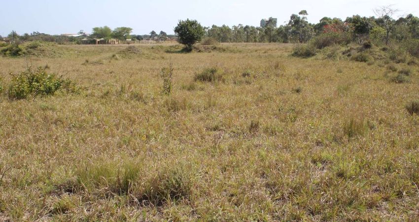
PROJECT RESPONSIBILITIES
Aspect Investigated         Specialist         Qualifications               Experience
Field work and report       Jacolette Adam     M.Sc. Zoology                Jacolette has 20 years of professional
review                                         LLM (Environmental Law)      experience in the environmental sector and
                                               Pr. Sci. Nat. (Zoological    has been a certified Professional Natural
                                                                            Scientist since 2002 (400088/02). She is
                                               Science)
                                                                            also a Fellow member of the Water Institute
                                               EAPASA                       of South Africa, Environmental Law
                                                                            Association of SA, the International
                                                                            Association for Impact Assessment South
                                                                            Africa and has successfully completed
                                                                            numerous environmental assessments
                                                                            throughout South Africa for a wide range of
                                                                            clients.
Field work and Wetland      Charleen Smuts     M.Sc. Plant Science          Charleen is a registered Professional
delineation          and                       Pr. Sci. Nat. (Botanical     Natural Scientist, member of the IAIASA
functionality assessment,                      Science)                     and the South Africa Wetland Society
                                                                            (SAWS). She has 8 years of experience
Author and GIS mapping
                                                                            and has conducted numerous ecological
and analysis                                                                and wetland delineation and functionality
                                                                            assessments. Furthermore, Charleen has
                                                                            been involved in a wide range of
                                                                            environmental authorisation projects.
Fieldwork
As with any major study it cannot be executed without assistance of fieldworkers. They were Kelly Lourens (BSc (Hons));
Madeleine Knoetze (BSc); Siphesihle Nkomo (B.SOC.Sc) and Ishmael Sikhonde (N5).

  AQUATIC BIODIVERSITY IMPACT ASSESSMENT SCOPING REPORT: Proposed development of the 450MW
         RMPP and associated infrastructure on sites located in Alton, Richards Bay, KwaZulu-Natal. – Exigent       2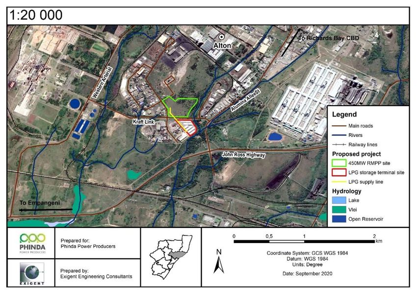
ABBREVIATIONS AND ACRONYMS
CARA                      Conservation of Agricultural Resources Act (Act 43 of 1983)
CBA                       Critical Biodiversity Area
CCPP                      Combined Cycle Power Plant
CITES                     Convention on International Trade in Endangered Species of Wild Fauna and Flora
CREW                      Custodians of Rare and Endangered Wildflowers
CSIR                      Council for Scientific and Industrial Research
DAFF                      Department of Agriculture, Forestry and Fisheries
DEA                       Department of Environmental Affairs
DEFF                      Department of Environment, Forestry and Fisheries
DHSWS                     Department of Human Settlements, Water and Sanitation
DO                        Dissolved Oxygen
DWA                       Department of Water Affairs
DWS                       Department of Water and Sanitation
EA                        Environmental Authorisation
EIA                       Environmental Impact Assessment
EIAR                      Environmental Impact Assessment Report
EIS                       Ecological Importance and Sensitivity
EMF                       Environmental Management Framework
EMP                       Environmental Management Plan
ESA                       Ecological Support Areas
ESMP                      Environmental Services Management Plan
GA                        General Authorisation (GN 509)
GG                        Government Gazette
GIS                       Geographical Information Systems
GN                        Government Notice
GPS                       Global Positioning System
HGM                       Hydro-Geomorphic (unit)
HRSG                      Heat Recovery Steam Generators
IPP                       Independent Power Producer
IUCN                      International Union for Conservation of Nature and Natural Resource
LNG                       Liquid Natural Gas
LPG                       Liquid Petroleum Gas
KCDM                      King Cetshwayo District Municipality
KZN                       KwaZulu-Natal Province
NEMA                      National Environmental Management Act (Act 107 of 1998)
NEMBA                     National Environmental Management: Biodiversity Act (Act 10 of 2004)
NEMPAA                    National Environmental Management: Protected Areas Act (Act 57 of 2003)
NERSA                     National Energy Regulator of South Africa
NFA                       National Forests Act (Act 84 of 1998)
NFEPA                     National Freshwater Ecosystems Priority Areas
NWA                       National Water Act (Act 36 of 1998)
NWCS                      National Wetland Classification System
PA                        Primary Aquifers
PAs                       Protected Areas in terms of NEMPAA
PES                       Present Ecological State
PRECIS                    National Herbarium Pretoria (PRE) Computerised Information System
PU                        Planning Unit
RMPPP                     Risk Mitigation Power Procurement Programme
SANBI                     South African National Biodiversity Institute
SARCA                     South African Reptile Conservation Assessment
SDF                       Spatial Development Framework

 AQUATIC BIODIVERSITY IMPACT ASSESSMENT SCOPING REPORT: Proposed development of the 450MW
        RMPP and associated infrastructure on sites located in Alton, Richards Bay, KwaZulu-Natal. – Exigent   3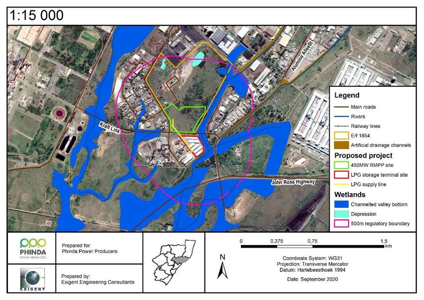
SIBIS                     Integrated Biodiversity Information System
SWSAs                     Strategic Water Source Areas
SWSA-gw                   Strategic Water Source Areas for ground water
SWSA-sw                   Strategic Water Source Areas for surface water
TOPS                      NEMBA Threatened or Protected Species
TSS                       Total suspended solids
TWQR                      Target Water Quality Range
ULM                       City of uMhlathuze Local Municipality
VEGMAP                    Vegetation Map of Southern Africa
WMA                       Water Management Area
WSAs                      Water Source Areas

 AQUATIC BIODIVERSITY IMPACT ASSESSMENT SCOPING REPORT: Proposed development of the 450MW
        RMPP and associated infrastructure on sites located in Alton, Richards Bay, KwaZulu-Natal. – Exigent   4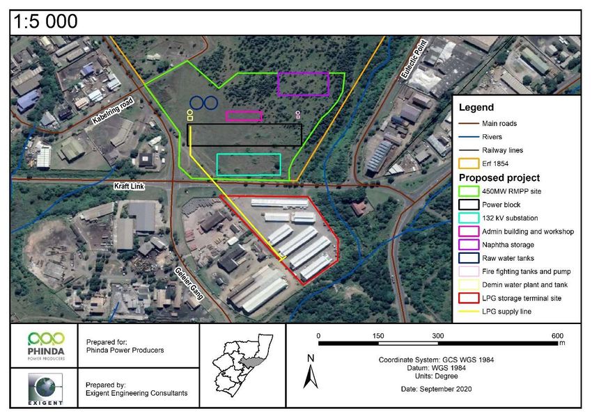
TABLE OF CONTENTS

1.      INTRODUCTION ............................................................................................................................................ 9
     1.1.        Project description ................................................................................................................................. 9
2.      SCOPE OF WORK....................................................................................................................................... 10
     2.1.        Aquatic Biodiversity Impact Assessment ............................................................................................. 11
3.      RELEVANT LEGISLATION .......................................................................................................................... 12
     3.1.        Biodiversity legislation ......................................................................................................................... 12
     3.2.        Provincial legislation and policy for buffers .......................................................................................... 13
4.      ASSUMPTIONS AND LIMITATIONS ........................................................................................................... 14
5.      DESCRIPTION OF RECEIVING ENVIRONMENT ....................................................................................... 14
     5.1.        Locality ................................................................................................................................................ 14
     5.2.        Biophysical description ........................................................................................................................ 15
6.      METHODOLODY AND DESKTOP RESULTS ............................................................................................. 19
     6.1.        Desktop evaluation .............................................................................................................................. 19
     6.2.        Literature review and database survey ................................................................................................ 19
     6.3.        Wetland assessment ........................................................................................................................... 24
     6.4.        Water Quality Assessment .................................................................................................................. 31
7.      RESULTS ..................................................................................................................................................... 32
     7.1.        Wetland assessment ........................................................................................................................... 32
     7.2.        Water quality........................................................................................................................................ 35
8.      IMPACT ASSESSMENT .............................................................................................................................. 36
     8.1.        Impact Assessment Methodology ........................................................................................................ 36
     8.2.        Assessment of Cumulative Impact ...................................................................................................... 37
     8.3.        Project Impact and Cumulative Assessment ....................................................................................... 37
9.      PLAN OF STUDY FOR EIA PHASE ............................................................................................................ 43
     9.1.        Key issues identified during the scoping process ................................................................................ 43
10.          RECOMMENDATIONS ............................................................................................................................ 45
     10.1.       Construction phase.............................................................................................................................. 45
     10.2.       Operational phase ............................................................................................................................... 46
11.          CONCLUSION ......................................................................................................................................... 46
12.          GLOSSARY ............................................................................................................................................. 47

      AQUATIC BIODIVERSITY IMPACT ASSESSMENT SCOPING REPORT: Proposed development of the 450MW
             RMPP and associated infrastructure on sites located in Alton, Richards Bay, KwaZulu-Natal. – Exigent                                                      5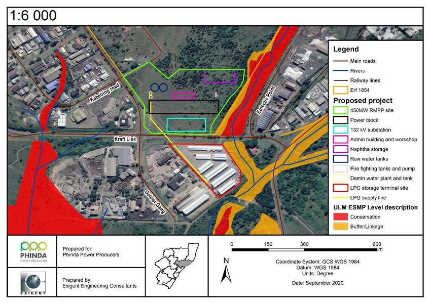
13.         REFERENCES ........................................................................................................................................ 48

                                                                        LIST OF TABLES
Table 6-1. Criteria for distinguishing different soil saturation zones and hydric vegetation within wetlands (from
Kotze et al., 1994). ................................................................................................................................................ 26
Table 6-2. Level 4 wetland classification............................................................................................................... 27
Table 6-3. Health categories used by WET-Health for describing the integrity of wetlands (Kleinhans et al., 1999;
Macfarlane et al., 2007). ....................................................................................................................................... 28
Table 6-4. Habitat assessment criteria for the wetlands on site (Source: Kotze et al., 2005). .............................. 28
Table 6-5. Four-point scale to assess biotic and habitat determinants that indicate importance or sensitivity...... 29
Table 6-6. Environmental Importance and Sensitivity rating scale used for calculation of EIS scores (DWAF, 1999).
.............................................................................................................................................................................. 29
Table 6-7. Ecosystem services included and assessed by WET-EcoServices (Kotze et al., 2005) ...................... 30
Table 9-1. Summary of key issues and impacts identified during the scoping phase of the proposed project...... 43

                                                                       LIST OF FIGURES
Figure 1-1. Locality of the proposed 450MW RMPP and associated infrastructure in Alton industrial area, Richards
Bay, KZN................................................................................................................................................................. 9
Figure 5-1. Land use where a) and b) depicts the undeveloped area proposed for the 450MW RMPP and
associated infrastructure and c) and d) the existing mini-factories and warehouses on the proposed LPG Storage
Terminal site. ........................................................................................................................................................ 15
Figure 5-2. The proposed 450MW RMPP and associated infrastructure setting. ................................................. 15
Figure 5-3. Hydrology of the study and surrounding areas ................................................................................... 17
Figure 5-4. Vegetation types of the study area (BGIS SANBI, 2018, EKZNW, 2011). .......................................... 19
Figure 6-1. NFEPA and NBA map depicting water and water related features within the study and surrounding area
(SANBI, 2018, Nel et al., 2011). ............................................................................................................................ 20
Figure 6-2. Critical Biodiversity Areas present in the study area. .......................................................................... 22
Figure 6-3. Municipal ESMP of the study area (SDF 2018). ................................................................................. 24
Figure 6-4. Terrain units. ....................................................................................................................................... 25
Figure 7-1. Channelled valley bottom wetland systems identified within the regulatory area of the proposed
development sites. ................................................................................................................................................ 33
Figure 7-2. Photographic presentation of Phragmites - Typha channelled valley bottom wetland adjacent to the
study area. ............................................................................................................................................................ 34
Figure 7-3. The proposed 450MW RMPP site excluding development in the buffer wetland zone. ...................... 35

      AQUATIC BIODIVERSITY IMPACT ASSESSMENT SCOPING REPORT: Proposed development of the 450MW
             RMPP and associated infrastructure on sites located in Alton, Richards Bay, KwaZulu-Natal. – Exigent                                                         6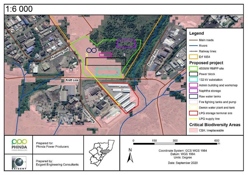
ADDENDUMS
Addendum A: Curriculum Vitae ............................................................................................................................. 50
Addendum B: Declaration of Independence ......................................................................................................... 51

    AQUATIC BIODIVERSITY IMPACT ASSESSMENT SCOPING REPORT: Proposed development of the 450MW
           RMPP and associated infrastructure on sites located in Alton, Richards Bay, KwaZulu-Natal. – Exigent                                        7
EXECUTIVE SUMMARY
Exigent Engineering Consultants CC has been appointed by Savannah Environmental (Pty) Ltd, on behalf of
Phinda Power Producers (Pty) Ltd, to conduct a specialist aquatic biodiversity impact assessment for the proposed
construction of a 450MW Emergency Risk Mitigation Power Plant and associated infrastructure on development
sites with a combined total extent of approximately 11,4 hectares, located in Alton industrial area, Richards Bay,
within the City of uMhlathuze Local Municipality and the King Cetshwayo District Municipality, KwaZulu-Natal
Province.
This study conforms to the requirements as set out in Government Notice No. 648 of Government Gazette 45421,
published on 10 May 2019, which provides the criteria for the assessment and reporting of impacts on aquatic
biodiversity for activities the terms of Government Notice No. 320 for the Procedures for the Assessment and
minimum criteria for reporting on identified environmental themes in terms of Sections 24(5)(a) and (h) and 44 of
the National Environmental Management Act 1998, when applying for an Environmental Authorisation, as released
on the 20 March 2020.
Due to the waterlogged nature of the lower laying areas of the coastal plain, three major stormwater drainage
channels were historically constructed to mitigate flooding and enable development in the Alton industrial area.
One of these drainage channels forms the eastern boundary of the proposed development site.
Wetlands were delineated based on the principles and guideline documents from the Department of Water Affairs
using wetland indicators such as wetland position in the landscape, soil form and wetness, as well as indicator
vegetation where possible. Four wetland units were identified within the Department of Human Settlement, Water
and Sanitation’s 500 m regulated area. Two were classified as Phragmites - Typha channelled valley bottom
wetlands; one located to the west of the proposed development site and the other along the eastern border of the
site. Two Imperata cylindrica depression wetlands are located upstream on Erf 1854 at the northern boundary of
the 500 m regulatory area. These depression wetlands will not experience change to one of the four main wetland
drivers, viz. habitat, biota, flow and water quality by the proposed development therefore, no further assessment
for the purposes of this development is required.
The Phragmites - Typha channelled valley bottom located at the eastern boundary of the site has experienced a
moderate change in ecosystem processes and a loss of natural habitats has taken place however the basic
ecosystem functions are still predominantly unchanged. This wetland is ecologically important and sensitive at a
local scale. A 29 m buffer has been set for the wetland from the Department of Human Settlement Water and
Sanitation guidelines for the determination of buffer zones for rivers, wetlands and estuaries by Macfarlane et al.
(2017). The proposed development has taken cognisance of the buffer zone, excluding activities from this area.
Species of special concern were recorded in the wetland and includes Ficus trichopoda and Barringtonia racemosa
individuals. The sensitivities presented were based on the findings of the site investigations to date. Final
recommendations and mitigation measures will be presented in the EIA phase.

   AQUATIC BIODIVERSITY IMPACT ASSESSMENT SCOPING REPORT: Proposed development of the 450MW
          RMPP and associated infrastructure on sites located in Alton, Richards Bay, KwaZulu-Natal. – Exigent   8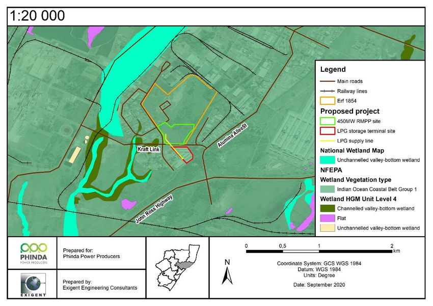
1. INTRODUCTION
Exigent Engineering Consultants CC (Exigent) has been appointed by Savannah Environmental (Pty) Ltd
(Savannah), on behalf of Phinda Power Producers (Pty) Ltd (Phinda), to conduct a specialist aquatic biodiversity
impact assessment for the proposed construction of a 450MW Emergency Risk Mitigation Power Plant (RMPP)
and associated infrastructure in Alton industrial area, Richards Bay, within the City of uMhlathuze Local Municipality
(ULM) and the King Cetshwayo District Municipality (KCDM), KwaZulu-Natal Province (KZN, Figure 1-1).

 Figure 1-1. Locality of the proposed 450MW RMPP and associated infrastructure in Alton industrial area,
 Richards Bay, KZN.

1.1. Project description

Phinda proposes the construction of a 450MW Emergency RMPP which involves the construction of a gas-fired
power station which will provide mid-merit power supply to the electricity grid.
The 450MW RMPP is planned to operate on a mid-merit basis at a minimum annual average dispatch rate of ~50%
(i.e. operational between 5am and 9:30pm daily and being deployed on average for a minimum 72% over the year
during this time period) and a maximum annual average dispatch rate of ~70%. The 450MW RMPP has been
designed and developed as a power balance system to manage electricity demand during day time peak periods
to provide energy, capacity and ancillary services to promote the stability of the national grid and assist in levelling
out the variability in renewables energy electricity supply and meet short term fluctuations in electricity demand. In
addition, the 450MR RMPP can provide back up support for daytime base load generation in the event of
unscheduled maintenance on Eskom’s base load electricity generation fleet.
The power station will have an installed capacity of up to 450MW, to be operated on either Liquid Petroleum Gas
(LPG) or naphtha as the initial fuel source and later to be converted from utilising LPG/naphtha to liquid natural

   AQUATIC BIODIVERSITY IMPACT ASSESSMENT SCOPING REPORT: Proposed development of the 450MW
          RMPP and associated infrastructure on sites located in Alton, Richards Bay, KwaZulu-Natal. – Exigent     9
gas (LNG). For the initial fuel source, either LPG would be supplied by road from the existing LPG import terminal
in Richards Bay or naphtha would be supplied via pipeline from the import berths at Richards Bay. Once LNG
import and regassification infrastructure is established in Richards Bay in accordance with the Department of
Minerals and Energy, Transnet Limited and the Independent Power Producer (IPP) Office’s planning, natural gas
would be supplied to the 450MW RMPP via a natural gas pipeline from this import terminal. The use of either
Naphtha or LPG and the associated infrastructure required in respect of each of these alternative fuel sources, will
be investigated further within the EIA phase and the preferred fuel source presented. The LNG terminal and
regassification infrastructure and naphtha supply infrastructure at the port of Richards Bay and the relevant
pipelines do not form part of the scope of this assessment, whereas LPG infrastructure does form part of this
report.
The main infrastructure associated with the facility includes the following:
Main Power Island consisting of either gas turbines comprising of air intake, air filter structures and exhaust
stack for the generation of electricity through the use of natural gas, naphtha or LPG; or Gas engines
comprising of reciprocating internal combustion engines and exhaust stack utilising LPG or natural gas.
Generator and Auxiliary transformers.
Balance of Plant systems.
Dry Cooling systems.
Auxiliaries.
132kV interconnecting substation and power lines connecting to the grid transmission infrastructure (The
power lines to the grid transmission structure will be applied for under a separate environmental approval
process).
LPG fuel pipe routing between the LPG storage site and the power plant site or Naphtha import pipeline from
the port of Richards Bay to the onsite storage of Naphtha (the Naphtha pipeline will be applied for under a
separate environmental approval process).
Stormwater management ponds.
LPG storage comprising of up to 15 000m3 of storage in total, comprising of a number of either bullets or
spheres storage tanks in design or;
Naphtha storage on the power plant site of up to 90,000m3 in total, comprising of a number of tanks.
Once imported LNG is available in Richards Bay, the 450MP RMPP will be converted from utilising LPG /
Naphtha to the use of regassified LNG by means of a new dedicated natural gas pipeline which will replace
or supplement the LPG / Naphtha supply to the power plant (The approval for the pipeline will be conducted
under a separate process).
3 effluent reticulation systems - i.e. 1) sanitary wastewater system; 2) oily water collection system and 3)
storm water and rainwater collection system.
Diesel generator to provide start-up power to the first gas engine / turbine.
This specific specialist report therefore entails an aquatic biodiversity scoping assessment for the proposed
450MW RMPP and associated infrastructure and reports on the environmental impacts that this proposed Plant
may have. The report will form part of the submissions to the National Department of Environment, Forestry and
Fisheries (DEFF) in terms of the National Environmental Management Act, 1998 (NEMA) (Act No. 108 of 1998)
and the 2014 Environmental Impact Assessment (EIA) Regulations, as amended in April 2017.
2. SCOPE OF WORK
This study conforms to the requirements as set out in Government Notice (GN) No. 648 of Government Gazette
(GG) 45421, published on 10 May 2019, which provides the criteria for the assessment and reporting of impacts
on aquatic biodiversity for activities the terms of GN No. 320 for the Procedures for the Assessment and minimum
criteria for reporting on identified environmental themes in terms of Sections 24(5)(a) and (h) and 44 of the National
Environmental Management Act (NEMA, Act 107 of 1998), when applying for an Environmental Authorisation (EA),
as released on the 20 March 2020.
AQUATIC BIODIVERSITY IMPACT ASSESSMENT SCOPING REPORT: Proposed development of the 450MW
RMPP and associated infrastructure on sites located in Alton, Richards Bay, KwaZulu-Natal. – Exigent 102.1. Aquatic Biodiversity Impact Assessment
The following will be included in the Aquatic Biodiversity Impact Assessment Report:
1. A description of the preferred development site. The baseline description will include:
A description of the aquatic biodiversity and ecosystems on the site, including:
o Aquatic ecosystem types;
o Presence of aquatic species and composition of aquatic species communities, their habitat,
distribution and movement patterns;
Threat status, including Listed Ecosystems, as well as locally important habitat types identified;
National and Provincial priority status of the aquatic ecosystem (i.e. is this a wetland or river
Freshwater Ecosystem Priority Area (FEPA), a FEPA sub catchment, a Strategic Water Source Area
(SWSA), whether or not they are free-flowing rivers, wetland clusters, etc., a CBA or an ESA;
including for all a description of the criteria for their given status; and
A description of the Ecological Importance and Sensitivity of the aquatic ecosystem including:
o The description of the ecosystem processes that operate in relation to the aquatic
ecosystems on and immediately adjacent to the site;
o The historic ecological condition (reference) as well as Present Ecological State (PES) of
rivers (in-stream, riparian and floodplain habitat) and/or wetlands in terms of possible
changes to the channel, flow regime (surface and groundwater).
2. Identify any alternative development footprints within the preferred development site which would be of a
“low” sensitivity and verified through the Initial Site Sensitivity Verification;
3. Assessment of impacts - a detailed assessment of the potential impact(s) of the proposed development
on the following very high sensitivity areas/ features:
Is the development consistent with maintaining the priority aquatic ecosystem in its current state and
according to the stated goal?
Is the development consistent with maintaining the Resource Quality Objectives for the aquatic
ecosystems present?
How will the development impact on fixed and dynamic ecological processes that operate within or
across the site, including:
o Impacts on hydrological functioning at a landscape level and across the site which can arise
from changes to flood regimes;
o Change in the sediment regime of the aquatic ecosystem and its sub-catchment;
o The extent of the modification in relation to the overall aquatic ecosystem; and
o Assessment of the risks associated with water use/s and related activities.
How will the development impact on the functionality of the aquatic feature, including:
o Base flows;
o Quantity of water including change in the hydrological regime or hydroperiod of the aquatic
ecosystem;
o Change in the hydrogeomorphic typing of the aquatic ecosystem;
o Quality of water;
o Fragmentation; and
o The loss or degradation of all or part of any unique or important features associated with or
within the aquatic ecosystem.
How will the development impact on key ecosystem regulating and supporting services especially:
o Flood attenuation;
o Streamflow regulation;
o Sediment trapping;
o Phosphate assimilation;
o Nitrate assimilation
o Toxicant assimilation;
o Erosion control; and
AQUATIC BIODIVERSITY IMPACT ASSESSMENT SCOPING REPORT: Proposed development of the 450MW
RMPP and associated infrastructure on sites located in Alton, Richards Bay, KwaZulu-Natal. – Exigent 11o Carbon storage.
How will the development impact community composition and integrity of the faunal and vegetation
communities inhabiting the site?
A motivation must be provided if there were development footprints that were identified as having a
“low” biodiversity sensitivity and were not considered appropriate.
4. The findings of this assessment are captured in this Aquatic Biodiversity Impact Assessment Report.
3. RELEVANT LEGISLATION
3.1. Biodiversity legislation
3.1.1. Constitution of the Republic of South Africa Act (Act 108 of 1996)
The Constitution of the Republic of South Africa Act (Act No. 108 of 1996) places a duty on the State and citizens
to protect the environment. Section 24 provides that:
“Everyone has the right –
(b) to have the environment protected, for the benefit of present and future generations through reasonable
legislative and other measures that
i) prevent pollution and ecological degradation.
ii) promote conservation.
iii) secure ecologically sustainable development and use of natural resources while promoting
iv) justifiable economic and social development”.
3.1.2. National Environmental Management Act (Act 107 of 1998)
The principles underpinning environmental management contained in the National Environmental Management
Act (Act 107 of 1998) (NEMA) must be considered by any organ of state in the exercise of any power that may
impact on the environment. Section 2 (4a) states that sustainable development requires the consideration of all
relevant factors including the following:
That the disturbance of ecosystems and loss of biological diversity are avoided, or where they cannot be
altogether avoided, are minimized and remedied.
That pollution and degradation of the environment are avoided, or, where they cannot be altogether
avoided, are minimized and remedied.
That the development, use and exploitation of renewable resources and the ecosystems of which they
are a part do not exceed the level beyond which their integrity is jeopardized.
That negative impacts on the environment and on people’s environmental rights be anticipated and
prevented, and where they cannot be altogether prevented, are minimized and remedied.
3.1.3. National Environmental Management: Biodiversity Act (Act 10 of 2004)
The National Environmental Management: Biodiversity Act (Act 10 of 2004) (NEMBA) addresses, amongst others:
Biodiversity planning and monitoring.
Protection of threatened or protected ecosystems.
Protection of threatened or protected species (TOPS).
The control of alien species, invasive species and genetically modified organisms.
Species that are classified as threatened and/or protected are listed in Government Gazette 151 of February 2007
and the regulations are included in Government Gazette 152 of February 2007, with the most recent amendment
in Government Notice 576 of July 2011.
AQUATIC BIODIVERSITY IMPACT ASSESSMENT SCOPING REPORT: Proposed development of the 450MW
RMPP and associated infrastructure on sites located in Alton, Richards Bay, KwaZulu-Natal. – Exigent 12Threatened ecosystems in need of protection are listed Government Notice 1002 of December 2011. The National
Environmental Management: Biodiversity Act (10/2004): Alien and Invasive Species Lists, 2016 (No 864) was
published on 29 July 2016 in GN 40166.
3.1.4. National Forest Act (Act 54 of 1998)
Government Gazette No 26731 of August 2004, and any later revisions as released, provide a list of tree species
protected under the National Forests Act. In terms of the National Forests Act, indigenous trees within a natural
forest or protected tree species may not be cut, disturbed, damaged or destroyed and their products may not be
possessed, collected, removed, transported, exported, donated, purchased or sold except under licence granted
by the Department of Environment, Forestry and Fisheries (DEFF, previously the Department of Agriculture,
Forestry and Fisheries), or a delegated authority. Applications for such activities should be made to the responsible
official in each province.
3.1.5. KZN Nature Conservation Ordinance (15 of 1974)
The KZN Nature Conservation Ordinance relates to nature conservation and concerns in the province. The
ordinance lists the protected and specially protected plants in the province and prohibits the picking, sale, export
or removal of protected plants. The ordinance also lists invader weeds, which must be controlled on study area
and may not be sold or donated.
Schedule 12 is a list of protected indigenous species which requires a permit prior to being exported from or
imported into the Province.
3.1.6. Additional biodiversity legislation
Locally, the South African Constitution, various Acts and two international treaties allow for the protection of
wetlands and rivers. Additional to the aforementioned legislation, these wetland systems are also protected from
destruction or pollution by the following:
Agenda 21 – Action plan for sustainable development of the Department of Environmental Affairs and
Tourism (DEAT) 1998.
The Ramsar Convention, 1971 including the Wetland Conservation Programme (DEAT) and the National
Wetland Rehabilitation Initiative (DEAT, 2000).
Conservation of Agricultural Resources Act (Act 43 of 1983).
Minerals and Petroleum Resources Development Act (Act 28 of 2002).
The Conservation of Agricultural Resources Act (CARA) (Act 43 of 1983) and the NEMBA also applies to this
project. CARA and NEMBA has categorised many invasive plants together with associated obligations of the
landowner.
3.2. Provincial legislation and policy for buffers
Previously, a standard 30 m buffer has been applied to wetlands in the province, disregarding site-specific
conditions. The Ezemvelo KZN Wildlife Biodiversity Impact Assessment Guideline (2013) have however compiled
criteria for determining the width of wetland and forest buffers based on the biophysical factors and the interactions
between them. Other policies that are relevant include:
Provincial Nature Conservation Ordinance (PNCO) – Protected Flora;
KZN Biodiversity Conservation Plan; and
KZN Vegetation Map (2011).
The buffers relevant to this study area will be determined using a combination of the EKZNW biodiversity guidelines
and the guidelines for the determination of buffer zones for rivers, wetlands and estuaries by Macfarlane et al.
(2017). The buffer model sheet for the results of the study area can be provided upon request.
AQUATIC BIODIVERSITY IMPACT ASSESSMENT SCOPING REPORT: Proposed development of the 450MW
RMPP and associated infrastructure on sites located in Alton, Richards Bay, KwaZulu-Natal. – Exigent 134. ASSUMPTIONS AND LIMITATIONS
The wetland boundaries mapped in this specialist report represent the approximate boundary on a gradient
between saturated and terrestrial soil as determined by a specialist experienced in the delineation technique.
On-site wetland boundaries were accurately surveyed for planning and mapping purposes. Wetlands
identified in the regulatory area has been desktop delineated.
In order to obtain a comprehensive understanding of the dynamics of the study area, as well as the status of
endemic, rare or threatened species in any area, assessments should always consider investigations at
different time scales (across seasons/years) and replication. Due to time constraints, such long-term studies
are not always feasible, and conclusions will be based on field surveys conducted on 18-20 September 2019
and 28-31 January 2020. A follow-up site visit is planned prior to the submission of the Aquatic Biodiversity
Impact Assessment Report during the Environmental Impact Assessment (EIA) phase of this project.
5. DESCRIPTION OF RECEIVING ENVIRONMENT
5.1. Locality
The development is proposed within the quarter degree grid cell 2832 CC and quaternary catchment W12F in the
Alton industrial area of Richards Bay within the jurisdiction of the ULM and the KCDM, KZN Province.
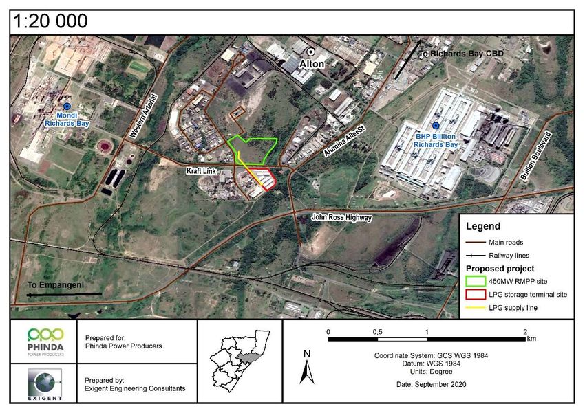
The proposed 450MW RMPP and its associated infrastructure is located north of Kraft link, on the southern section
of Erf 1854. With the centre point geographical coordinates at 28°45'58.62"S and 32°00'39.55"E. The proposed
LPG storage terminal is located south of Kraft Link on Lot 1795 of the Richards Bay Industrial Park Portions 6-18
at centre point coordinates at 28°46'7.52"S and 32°00'44.11"E. The 450MW RMPP site will be accessed on the
west side from the existing Kabelring road (Figure 5-2).
The 450MW RMPP and its associated infrastructure are proposed on an undeveloped area while existing mini-
factories and warehouses exist on the proposed LPG Storage Terminal site. These structures will be demolished
in order to accommodate the proposed development (Figure 5-1).
a) b)
AQUATIC BIODIVERSITY IMPACT ASSESSMENT SCOPING REPORT: Proposed development of the 450MW
RMPP and associated infrastructure on sites located in Alton, Richards Bay, KwaZulu-Natal. – Exigent 14c) d)
Figure 5-1. Land use where a) and b) depicts the undeveloped area proposed for the 450MW RMPP and
associated infrastructure and c) and d) the existing mini-factories and warehouses on the proposed
LPG Storage Terminal site.
Figure 5-2. The proposed 450MW RMPP and associated infrastructure setting.
5.2. Biophysical description
5.2.1. Climate
The climate of the study area can be described as summer rainfall towards the interior but comprise generally of a
weak rainfall seasonality, especially closer to the coast. It experiences relatively high precipitation reaching mean
annual precipitation values of approximately 1200 mm in coastal localities, decreasing to the interior. High humidity
AQUATIC BIODIVERSITY IMPACT ASSESSMENT SCOPING REPORT: Proposed development of the 450MW
RMPP and associated infrastructure on sites located in Alton, Richards Bay, KwaZulu-Natal. – Exigent 15and temperature are experienced during summer months with the mean maximum being 35.3 °Celsius and a mean
winter temperature of 5.5 °Celsius. No incidence of frost is recorded within the study area (Mucina & Rutherford,
2006).
5.2.2. Geology and geography
The study area is generally characterised as a relatively flat landscape. It comprises of 18 000 years old quaternary
sediments of marine origin mainly with yellowish and argillaceous redistributed sands of the Berea and Muzi
Formations (Maputaland Group). The soils are nutritiously very poor and well leached, except in the interdune
depressions were organic-rich soils are often present (Mucina & Rutherford, 2006). The main land types “Ha” and
“Hb” present on site may include the Constantia, Shepstone and Vilafontes soil forms while the less distributed
“Db” land type on site is associated with a wide variety of geological units such as the basement granites, Natal
Group sandstones, Dwyka tillites, Ecca shales and sandstones, mudstones, shale and/or sandstones of the
Escourt, Emakwezini, Nyoka, Ntabene and Clarens Formations, siltsrone/sandstone of the Zululand Group and
some Cenozoic deposits. The “Db” broad soil pattern is generally situated in low gradient slopes and are therefore
prone to inundation/flooding. “Db” landtype unit is characterised by duplex soils with non–red B horizons (Council
for Geoscience, 2012).
The site is underlain by the KwaMbonambi Formation which forms part of the Maputaland Group. The older Port
Durnford Formation consists of mainly carbonaceous mudstone and claystones. The KwaMbonambi Formation
consists of a variety of grey, orange and red sands. Peat occurs on the seaward, wetter margins of this formation
(Roberts et al., 2006). According to Grundling & Grobler (2005), peat accumulates mostly along the eastern and
southern coastline and the eastern parts of the central plateau in wetter areas of the country. They are very rare
and unique wetland types of Southern Africa that provide an important ecosystem habitat due to the diversity that
they support, their size, distribution and threats (Grundling & Grobler, 2005). No peat soils were detected during
the site visit.
The Agricultural Potential and Soils Impact Assessment Report conducted for the proposed study (Phipson, 2020)
confirms that the proposed project site is underlain mostly by the Fernwood Soil Form whilst the Witbank Soil Form
was classified below the building rubble and road building detritus mounds located on the proposed development
site.
5.2.3. Hydrology
The National Freshwater Ecosystems Priority Areas (NFEPA) used Water Source Areas (WSAs) to create a
database that present various water and water related layers, including wetland delineation and vegetation data,
catchment data, area of high groundwater recharge and water management areas using the criterion of the
production of relatively large volumes of runoff which sustain lowland areas downstream. This work was then taken
further in a study by the World Wide Fund for Nature – South Africa (WWF-SA) and the Council for Scientific and
Industrial Research (CSIR) who identified 21 Strategic WSAs for surface water (SWSA-sw) which covered 8% of
South Africa and supplied 50% of the mean annual runoff. More recently, the Water Research Commission (WRC)
funded a study which identified water source areas for both ground and surface water resources (BGIS SANBI
2017). Strategic Water Source Areas (SWSAs) are now defined as areas of land that either:
(a) supply a disproportionate (i.e. relatively large) quantity of mean annual surface water runoff in relation
to their size and so are considered nationally important; or
(b) have high groundwater recharge and where the groundwater forms a nationally important resource; or
(c) areas that meet both criteria (a) and (b). They include transboundary Water Source Areas that extend
into Lesotho and Swaziland.
Based on the BGIS SANBI SWSAs database (2017) the study area is strategically important at the national level
for water and economic security for South Africa as it lies in both the Zululand Coast surface water and the Richards
Bay ground water-fed estuary SWSA. The accuracy of these delineations in the proposed development sites will
AQUATIC BIODIVERSITY IMPACT ASSESSMENT SCOPING REPORT: Proposed development of the 450MW
RMPP and associated infrastructure on sites located in Alton, Richards Bay, KwaZulu-Natal. – Exigent 16be determined from review of the surface and groundwater specialist reports in combination with ground truthing
during the EIA phase of the project.
Surface Water
The study area falls within the Pongola to Mtamvuna Water Management Area (WMA, GN 1056 in GG 40279 of
16 September 2016). This WMA includes major rivers such as the Pongola, Mhlathuze, Mkuze, Thukela, Mvoti
and Umgeni Rivers amongst various others, within the quaternary catchment W12F. The major water resources of
the uMhlathuze Catchment is uMhlathuze and Nseleni rivers, Goedertrouw dam and several irrigation dams and
impoundments, several lakes and pans (such as Lake Cubhu, Mzingazi Lake, Nhlabane Lake and Nsezi Lake),
riparian areas along most of the riverine habitat, hillslope seepages, valley bottom wetland systems and Mhlathuze
River Floodplain and Estuary. The most important wetland systems within the Umhlathuze Catchment are
Mzingazi, Qhubu and Nhlabane Lake (as it supplies water to Richards Bay and surroundings), Mhlatuze Floodplain,
Mhlatuze Estuary and its associated valley bottom wetland feeding into it, and Mountainous seeps in the upper
reaches of Mhlatuze River (DWA, 2014).
The National spatial data (November, 2017) identifies several non-perennial and perennial rivers, lakes, vleis and
open reservoirs in Alton of which only one perennial river runs directly adjacent to the 450MW RMPP and LPG
Storage Terminal sites (Figure 5-3). Historically, a stormwater drainage channel was constructed in this river
channel to mitigate flooding and enable development in the Alton industrial area. Although it has historically been
artificially channelled, the channel bed is earthen and therefore functions as a natural river and associated wetland
unit.
Figure 5-3. Hydrology of the study and surrounding areas
Based on ground truthing, four natural wetland units were identified within the DHSWS’ 500 m regulated area. Two
were classified as Phragmites - Typha channelled valley bottom wetlands; one located to the west of the proposed
AQUATIC BIODIVERSITY IMPACT ASSESSMENT SCOPING REPORT: Proposed development of the 450MW
RMPP and associated infrastructure on sites located in Alton, Richards Bay, KwaZulu-Natal. – Exigent 17development site and the other along the eastern border of the site. Two Imperata cylindrica depression wetlands
are located upstream on Erf 1854 at the northern boundary of the 500 m regulatory area. These depression
wetlands will not experience change to one of the four main wetland drivers, viz. habitat, biota, flow and water
quality by the proposed development therefore, no further assessment for the purposes of this development is
required. A description of the channelled valley bottom wetlands are presented in section 7.1 of this report.
Resource Class, Resource Quality Objectives (RQO) and Reserve Determination
The water resources within this catchment has been awarded a PES rating of C (Moderately modified) and an EIS
rating of Moderate. The river associated with the W12F quaternary catchment area is the Mhlathuze River with the
catchment infrastructure the Mhlathuze Lagoon (DWA, 2014).
The aquatic resources are under threat from current land use practices and over-utilisation of water resources.
Existing water resources should be protected through water conservation measures such as removal of alien
invasive species, rehabilitation of wetlands, limiting groundwater abstraction to the set sustainable yield and
minimizing the pollution of water resources (DWA, 2014).
Groundwater
The groundwater recharge of South Africa has been mapped and distributed as part of the National Freshwater
Ecosystems Priority Areas (NFEPA) in 2011. This data aimed to provide the sub-quaternary catchments where the
groundwater recharge was three-times higher than the average recharge ratio. Areas of high groundwater recharge
are not necessarily classified as FEPAs, however they can be perceived as the ‘recharge hotspots’ of a region. It
is critical to maintain the natural habitat in these areas of high groundwater recharge as to protect the functioning
of the groundwater dependent ecosystems. Areas of groundwater recharge values higher than 300 indicate high
groundwater recharge areas. In KwaZulu-Natal, there are no areas of high groundwater recharge. The study area
has a groundwater recharge ratio of 170.
The aquifer classification map of South Africa has indicated that the study area has been identified as a major
aquifer system. The water source in this area is surface water. According to the groundwater quality map of South
Africa the electrical conductivity of the groundwater in the area ranges between 0 to 70 mS/m (millisiemens per
metre).
The Geotechnical Investigation (Davies Lynn & Partners, 2019) conducted for the proposed development records
groundwater seepage was encountered at depths ranging between 1,8 m and up to 2,7 m below existing ground
levels in nine of the twenty Inspection Pit excavations. The standpipe piezometers installed in the Boreholes further
revealed that the groundwater elevation is expected to be encountered at depths ranging between 2,25 m (BH 3-
19), 3,28 m (BH 1-19) and up to 4,15 m (BH 2-19) below existing ground levels. Additionally, the shallow, less
permeable recent sandy clay layers should be anticipated to retard vertical drainage and possibly give rise to
temporary perched seepage water after prolonged periods of heavy rainfall.
5.2.4. General description of the vegetation of the area
The study area is located within the Indian Ocean Coastal Belt Biome, located within the Maputaland Coastal Belt
vegetation type (Mucina & Rutherford, 2006). According to the National vegetation data (BGIS SANBI, 2018) and
Ezemvelo KZN Wildlife (EKZNW, 2011), the 450MW RMPPP Power Plant and its associated infrastructure is
located within the Maputaland Wooded Grassland. Both databases identify Ficus trichopoda swamp forest
approximately 170 m to the west, outside of the proposed development area.
According to the Ecosystem Threat Status of the National Biodiversity Assessment (NBA, SANBI 2018) and
EKZNW (2011) the Maputaland Wooded Grassland is classified as Endangered.
AQUATIC BIODIVERSITY IMPACT ASSESSMENT SCOPING REPORT: Proposed development of the 450MW
RMPP and associated infrastructure on sites located in Alton, Richards Bay, KwaZulu-Natal. – Exigent 18Figure 5-4. Vegetation types of the study area (BGIS SANBI, 2018, EKZNW, 2011).
However, following ground truthing, much of the area identified as Maputaland Wooded Grassland is, in fact
industrial development. Vegetation confirmed on the development site resembles that of Maputaland Wooded
Grassland albeit the natural woody layer has been greatly reduced. Detailed vegetation information is presented
in the Ecological Biodiversity Impact Assessment Scoping Report for the proposed project (Exigent, 2020).
6. METHODOLODY AND DESKTOP RESULTS
6.1. Desktop evaluation
Prior to conducting the physical study area visit and wetland delineation, an initial level 1 (desktop) survey was
done using Google Earth’s map timeline function to detect changes in visible vegetation gradients. Maps are
available from 2004-2019. Possible wetlands were identified, and GPS coordinates were noted to assist with the
study area visit.
6.2. Literature review and database survey
A literature survey and database review were conducted to assist with the study. The full reference to resources
used is listed in Section 13. The broad-scale national databases are used as baseline with focus then shifting to
the available ULM databases.
6.2.1. National databases
The Integrated Biodiversity Information System (SIBIS) database from the South African National Biodiversity
Institute (SANBI) contains information from several SANBI databases, namely:
AQUATIC BIODIVERSITY IMPACT ASSESSMENT SCOPING REPORT: Proposed development of the 450MW
RMPP and associated infrastructure on sites located in Alton, Richards Bay, KwaZulu-Natal. – Exigent 19 Acocks (plant species observations);
Custodians of Rare and Endangered Wildflowers (CREW) (threatened plant species localities);
Garden Accessions (plant collection records);
MSB (plant seed collection records);
National Herbarium Pretoria (PRE) Computerised Information System (PRECIS) (taxonomy and
herbarium specimens);
Species Status (NEMBA-listed species);
TSP (threatened plant species);
National Freshwater Ecosystems Priority Areas (NFEPA) – (Nel et al., 2011);
National Spatial Biodiversity Assessment (2018).
NFEPA database includes various water and water related layers, including wetland delineation and vegetation
data, catchment data, areas of high groundwater recharge and water management areas. Based on the NFEPA
database, the study area lies within the Indian Ocean Coastal Belt Group 1 wetland vegetation type with a
channelled valley bottom wetland located to the west, outside the development area. The NBA database classified
the mid-section of this wetland unit as a unchannelled valley bottom wetland (SANBI, 2018) This wetland unit was
identified during the site visit and is described with the wetland systems in Section 7.1 of this report.
Figure 6-1. NFEPA and NBA map depicting water and water related features within the study and
surrounding area (SANBI, 2018, Nel et al., 2011).
The development is proposed in the Indian Ocean Coastal Belt Group 1 but lies outside any wetlands identified in
the NBA and NFEPA databases.
AQUATIC BIODIVERSITY IMPACT ASSESSMENT SCOPING REPORT: Proposed development of the 450MW
RMPP and associated infrastructure on sites located in Alton, Richards Bay, KwaZulu-Natal. – Exigent 206.2.2. Provincial databases
The EKZNW Strategic Environmental Assessment (SEA) Database (2000) was used to model the distribution of a
selection of 255 red data and endemic species.
The EKZNW Conservation Plan (C-Plan) was used in a GIS assessment of the study area. This database includes
the layers of the following databases:
National Land Cover 2000 (ver.1.2) edited for errors known to occur in provincial protected areas (January
2004);
Provincial and national protected areas of the province (EKZNW);
National Vegetation Map (BGIS SANBI, 2018);
Forests of KZN (EKZNW, 2003);
Wetlands of KZN (EKZNW, 2004);
Biophysical data from Schulze, R.E. (1997);
South African Atlas of Agrohydrology and Climatology. Water Research Commission, Pretoria; and
Species distributions from Ezemvelo KZN Wildlife’s Biodiversity database and supplemented by species
specialist group records and inputs (EKZNW).
The first use of the conservation planning analysis in C-Plan is an irreplaceability map of the planning area. This
map is divided into 2 x 2 km grid cells called ‘planning units’. Each cell has associated with it an ‘Irreplaceability
Value’ which is one reflection of the cell’s importance with respect to the conservation of biodiversity. Irreplaceability
reflects the planning units’ ability to meet set ‘targets’ for selected biodiversity ‘features’ (EKZNW, 2004, Incomplete
Draft). Where a planning unit has an irreplaceability value of 0, all biodiversity features recorded here are conserved
to the target amount within reserves in South Africa, and there is unlikely to be a biodiversity concern with the
development within the study area. An irreplaceability value of 1 would imply there are various issues of biodiversity
concern within the study area, which requires conservation and, therefore, development of the study area is not
recommended.
Minset is a feature that is utilized within the C-Plan. This tool uses a minimum amount of study areas to optimize
the achievement of conservation targets by placing numerous constraints on the users. It presents the most
efficient solution to achieving conservation targets and other land use constraints (EKZNW, 2011).
The EKZNW Minset data classifies the major conservation areas into 4 main categories:
Critical Biodiversity Area (CBA) Mandatory: These are areas that have no other options than to meet their
required biodiversity targets for both the biodiversity patterns and the ecological process features. This category is
subdivided into two sets, depending on the irreplaceability of the area.
o CBA 1 Mandatory areas have an irreplaceability score that is equal to 1, meaning that the area
is highly irreplaceable.
o CBA 2 Mandatory areas have an irreplaceability score that lies between 0.8 and is smaller than
1.
CBA Optimal: These areas are ideal areas to meet their biodiversity conservation targets whilst aiming to avoid
high cost areas. This classification is allocated to areas with an irreplaceability score that lies between 0 and 0.8.
This category as well as the CBA Mandatory Areas are determined by the National Threatened Ecosystems, the
National and KZN Protected Area Expansion Strategy, the KZN threatened Ecosystems, Forests and macro-
ecological corridors that are in areas that are under great environmental pressures.
Ecological Support Areas (ESA): Areas that are not essential for meeting biodiversity targets directly. However,
they do play an important role in supporting and sustaining the ecological functioning of the CBAs. These areas
are determined by the macro-ecological corridors.
AQUATIC BIODIVERSITY IMPACT ASSESSMENT SCOPING REPORT: Proposed development of the 450MW
RMPP and associated infrastructure on sites located in Alton, Richards Bay, KwaZulu-Natal. – Exigent 21Ecological Infrastructure (EI) or previously known as Ecosystem Goods and Service Areas (EGSA): These are
areas that are classified as natural/near natural vegetation which has the capability of delivering important
ecosystem goods and services to the KZN province and the inhabitants of the land.
Based on the EKZNW CBA data, the 450MW RMPP and LPG Storage Terminal sites are proposed within an
irreplaceable area (Figure 6-2). These areas are considered critical for meeting biodiversity targets and thresholds
and are required to ensure the persistence of viable populations of species and the functionality of ecosystems.
The Land use management objectives are to maintain these areas in a natural state with limited to no biodiversity
loss (EKZNW, 2016).
Figure 6-2. Critical Biodiversity Areas present in the study area.
According to EKZNW (2016), the planning units (PU) identified in these CBA’s represents the localities for one or
more biodiversity feature for which conservation targets can be achieved. The distribution of the biodiversity
features is not always applicable to the entire extent of the PU but is more often confined to a specific niche habitat
e.g. a forest or wetland reflected as a portion of the PU.
As seen by the pixelated blocks and inclusion of transformed industrial areas in Figure 6-2, these CBA areas are
provincially mapped at a large scale. The site may have been incorrectly classified as CBA due to an error in the
land cover map, or alternatively a disturbance to the site has occurred subsequent to the development of the CBA
Map. The site must be assessed for its potential to be rehabilitated and/or its role as part of a landscape corridor
and the potential presence of protected species. Further, the proposed activity at the site should be investigated
in terms of its potential impact on adjacent correctly classified CBA and ESA’s.
Recommended mitigation such as the exclusion of the wetland and its associated buffer zone from the proposed
project and implementation of specific mitigation measures, as presented in section 8.3 of this report, may allow
for sufficient conservation of this PU as well as allow for development within the proposed project footprint.
AQUATIC BIODIVERSITY IMPACT ASSESSMENT SCOPING REPORT: Proposed development of the 450MW
RMPP and associated infrastructure on sites located in Alton, Richards Bay, KwaZulu-Natal. – Exigent 22You can also read