ARCHAEOLOGICAL DESKTOP STUDY - for the Application of a Prospecting Right on the Farm Highlands 392 HO and Portions 4 and 6 of the Farm Roodepoort ...
←
→
Page content transcription
If your browser does not render page correctly, please read the page content below
ARCHAEOLOGICAL
       DESKTOP STUDY

for the Application of a Prospecting Right
    on the Farm Highlands 392 HO and
Portions 4 and 6 of the Farm Roodepoort
   206 HO, Wolmaransstad, North West

                   Author ©:
     Tobias Coetzee, MA (Archaeology) (UP)
                 February 2020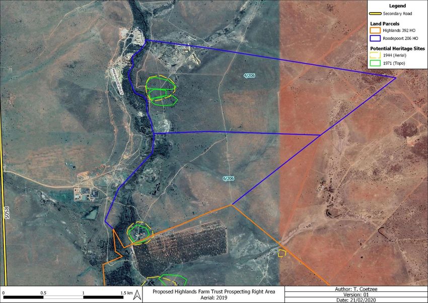
An Archaeological Desktop Study for the Application of a Prospecting Right
on the Farm Highlands 392 HO and Portions 4 and 6 of the Farm Roodepoort
206 HO, Wolmaransstad, North West
For: Terra Africa Consult
P.O. Box 433
Ottosdal
2610
Report No: HighlandsFarmTrust_2202201
Email: tobias.coetzee@gmail.com
I, Tobias Coetzee, declare that –
I act as the independent specialist;
I am conducting any work and activity relating to the proposed Highlands Farm Trust Project
in an objective manner, even if this results in views and findings that are not favourable to
the client;
I declare that there are no circumstances that may compromise my objectivity in performing
such work;
I have the required expertise in conducting the specialist report and I will comply with
legislation, regulations and any guidelines that have relevance to the proposed activity;
I have not, and will not engage in, conflicting interests in the undertaking of the activity;
I undertake to disclose to the applicant and the competent authority all material information
in my possession that reasonably has or may have the potential of influencing - any
decision to be taken with respect to the application by the competent authority; and - the
objectivity of any report, plan or document to be prepared by myself for submission to the
competent authority;
All the particulars furnished by me in this declaration are true and correct.
_________________________________
Date: 22 February 2020
Tobias Coetzee ©
HighlandsFarmTrust_2202201
February 2020
2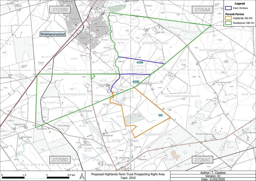
Executive Summary
       The author was appointed by Terra Africa Consult to undertake an Archaeological Desktop study for Highlands
       Farm Trust on the following Farm Portions within the Maquassi Hills Local Municipality and the Dr Kenneth Kaunda
       District Municipality in the North West Province: The Farm Highlands 392 HO and Portions 4 & 6 of the Farm
       Roodepoort 206 HO. The study area is located roughly 2 km north of the town of Makwassie, 4.5 km south of
       Wolmaransstad and 23 km west of Leeudoringstad. The aim of this report is to contextualise the general study
       area in terms of heritage resources and will provide the applicant with general information regarding potentially
       sensitive areas. This will also shed light on what is to be expected during a Phase 1 Archaeological Impact
       Assessment and aid in interpreting finds.

       Buildings and kraals existed on all three land parcels in historical times. Some of these structures appear to have
       been demolished (Portion 4 of the Farm Roodepoort 206 HO), while some buildings associated with the areas
       where historical buildings were observed, are still present. It is also possible that subsurface culturally significant
       material might still exist in the general vicinity of these localities. Therefore, it is recommended that the areas
       demarcated as ‘Potential Heritage Sites’ on Figures 3 & 4 be avoided by the proposed prospecting activities.
       Should this not possible, a qualified archaeologist should be present on-site during prospecting in order to limit
       potential impact on heritage resources and provide the required input. A full Phase 1 AIA must be done should any
       development that triggers an AIA result from the prospecting, including if the cumulative impact of the proposed
       prospecting exceeds 0.5 ha. Also, not all heritage material/sites are visible on aerial photographs or topographical
       maps and may include sites such as informal cemeteries or burial sites. Care should therefore be exercised when
       prospecting in the vicinity of stone cairns or any built environment.

Tobias Coetzee ©
HighlandsFarmTrust_2202201
February 2020
                                                                                                                    3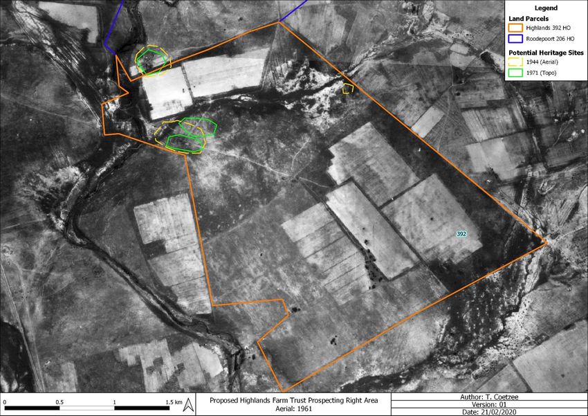
Table of Contents
Executive Summary .................................................................................................................... 3
1. Project Background.............................................................................................................. 6
  1.1        Introduction ...................................................................................................................................... 6
  1.2        Legislation ........................................................................................................................................ 8
     1.2.1      The EIA and AIA processes......................................................................................................... 8
     1.2.2      Legislation regarding archaeology and heritage sites ................................................................. 9
2. Study Area and Project Description .................................................................................. 12
  2.1        Location & Physical Environment ............................................................................................. 12
  2.2        Project description ...................................................................................................................... 13
3. Archaeological Background .............................................................................................. 19
  3.1        The Stone Age ............................................................................................................................... 19
  3.2        The Iron Age & Historical Period ................................................................................................... 20
  3.3        Previous Heritage Studies ............................................................................................................. 22
4. Evaluation ........................................................................................................................... 22
5. Statement of Significance & Recommendations .............................................................. 23
  5.1        Statement of significance............................................................................................................... 23
  5.2        Recommendations ......................................................................................................................... 25
6. Addendum: Terminology ................................................................................................... 26
7. References .......................................................................................................................... 27
Appendix A: Historical Topographical Maps & Aerial Imagery................................................A

Tobias Coetzee ©
HighlandsFarmTrust_2202201
February 2020
                                                                                                                                                         4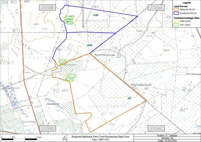
List of Figures
Figure 1: Regional and Provincial location of the study area. ........................................................................................... 7
Figure 2: Segments of SA 1: 50 000 2725 BB, 2725 BD, 2726 AA & 2726 AC indicating the study area....................... 16
Figure 3: Proposed Highlands 392 HO section on an aerial backdrop. .......................................................................... 17
Figure 4: Proposed Roodepoort 206 HO section on an aerial backdrop. ........................................................................ 18
Figure 5: LSA scrapers (Klein 1984). .............................................................................................................................. 20
Figure 6: MSA artefacts from Howiesons Poort (Volman 1984)...................................................................................... 20
Figure 7: LSA scrapers (Klein 1984). .............................................................................................................................. 20
Figure 8: Segments of 1964-1971 SA 1: 50 000 2725 BB, 2725 BD, 2726 AA & 2726 AC indicating the study area. .....B
Figure 9: 1944 Aerial Image indicating the Highlands 392 HO section. ........................................................................... C
Figure 10: 1944 Aerial Image indicating the Roodepoort 206 HO section. ...................................................................... D
Figure 11: 1949 Aerial Image indicating the Highlands 392 HO section. ..........................................................................E
Figure 12: 1949 Aerial Image indicating the Roodepoort 206 HO section. ....................................................................... F
Figure 13: 1961 Aerial Image indicating the Highlands 392 HO section. ......................................................................... G
Figure 14: 1961 Aerial Image indicating the Roodepoort 206 HO section. ...................................................................... H
Figure 15: 1970 Aerial Image indicating the Highlands 392 HO section. ........................................................................... I
Figure 16: 1970 Aerial Image indicating the Roodepoort 206 HO section. ....................................................................... J

List of Tables
Table 1: Property name & coordinates............................................................................................................................ 12

Tobias Coetzee ©
HighlandsFarmTrust_2202201
February 2020
                                                                                                                                                            5
1.     Project Background
1.1 Introduction
       Terra Africa Consult appointed the author to undertake an Archaeological Desktop study for Highlands Farm Trust
       on the following Farm Portions near Wolmaransstad in the North West Province: The Farm Highlands 392 HO
       and Portions 4 and 6 of the Farm Roodepoort 206 HO. The study area is located roughly 2 km north of the town
       of Makwassie, 4.5 km south of Wolmaransstad and 23 km west of Leeudoringstad (Figures 1 & 2). The purpose
       of this study is to contextualise the demarcated study area in order to determine the scope of heritage resources
       that might be encountered during the prospecting phase and subsequent heritage studies, as well as to provide
       recommendations for the safeguarding of archaeological resources during prospecting. The aim of this report is
       to provide the applicant with information regarding heritage resources in the vicinity of the study area based on
       results from previous studies, written historical information and historical topographical maps and aerial
       photographs.

       In the following report, I provide a broad overview of the proposed alluvial diamonds and diamonds in general
       prospecting and contextualise the study area in terms of heritage resources. The legislation section included
       serves as a guide towards the effective identification and protection of heritage resources and will apply to any
       such material unearthed during the prospecting phase.

Tobias Coetzee ©
HighlandsFarmTrust_2202201
February 2020
                                                                                                                6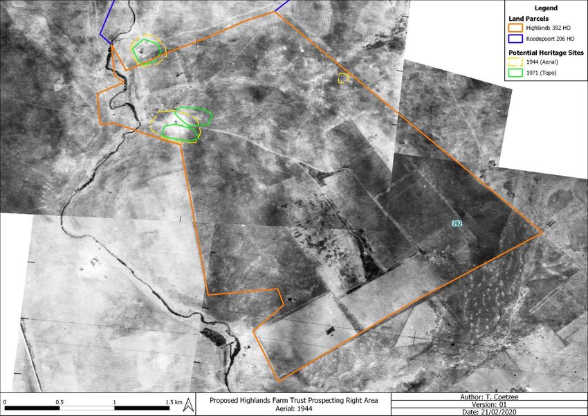
Figure 1: Regional and Provincial location of the study area.

Tobias Coetzee ©
HighlandsFarmTrust_2202201
February 2020                                                                     7
1.2 Legislation
       The South African Heritage Resources Agency (SAHRA) aims to conserve and control the management,
       research, alteration and destruction of cultural resources of South Africa and to prosecute if necessary. It is
       therefore crucially important to adhere to heritage resource legislation contained in the Government Gazette of
       the Republic of South Africa (Act No.25 of 1999), as many heritage sites are threatened daily by development.
       Conservation legislation requires an impact assessment report to be submitted for development authorisation that
       must include an AIA if triggered.

       AIAs should be done by qualified professionals with adequate knowledge to (a) identify all heritage resources that
       might occur in areas of development and (b) make recommendations for protection or mitigation of the impact of
       the sites.

1.2.1 The EIA and AIA processes

       Phase 1 Archaeological Impact Assessments generally involve the identification of sites during a field survey with
       assessment of their significance, the possible impact that the development might have, and relevant
       recommendations.
       All Archaeological Impact Assessment reports should include:

         a.   Location of the sites that are found;

         b.   Short descriptions of the characteristics of each site;

         c.   Short assessments of how important each site is, indicating which should be conserved and which
              mitigated;

         d.   Assessments of the potential impact of the development on the site(s);

         e.   In some cases a shovel test, to establish the extent of a site, or collection of material, to identify the
              associations of the site, may be necessary (a pre-arranged SAHRA permit is required); and

         f.   Recommendations for conservation or mitigation.

         This AIA report is intended to inform the client about the legislative protection of heritage resources and their
         significance and make appropriate recommendations. It is essential to also provide the heritage authority with
         sufficient information about the sites to enable the authority to assess with confidence:

         a.   Whether or not it has objections to a development;

         b.   What the conditions are upon which such development might proceed;

Tobias Coetzee ©
HighlandsFarmTrust_2202201
February 2020
                                                                                                                  8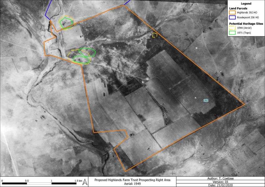
c.     Which sites require permits for mitigation or destruction;

           d.     Which sites require mitigation and what this should comprise;

           e.     Whether sites must be conserved and what alternatives can be proposed to relocate the development
                  in such a way as to conserve other sites; and

           f.     What measures should or could be put in place to protect the sites which should be conserved.

           When a Phase 1 AIA is part of an EIA, wider issues such as public consultation and assessment of the spatial
           and visual impacts of the development may be undertaken as part of the general study and may not be required
           from the archaeologist. If, however, the Phase 1 project forms a major component of an AIA it will be necessary
           to ensure that the study addresses such issues and complies with Section 38 of the National Heritage Resources
           Act.

1.2.2 Legislation regarding archaeology and heritage sites

       National Heritage Resource Act No.25 of April 1999

       Buildings are among the most enduring features of human occupation, and this definition therefore includes all
       buildings older than 60 years, modern architecture as well as ruins, fortifications and Farming Community
       settlements. The Act identifies heritage objects as:

       -          objects recovered from the soil or waters of South Africa, including archaeological and palaeontological
                  objects, meteorites and rare geological specimens;

       -          visual art objects;

       -          military objects;

       -          numismatic objects;

       -          objects of cultural and historical significance;

       -          objects to which oral traditions are attached and which are associated with living heritage;

       -          objects of scientific or technological interest;

       -          books, records, documents, photographic positives and negatives, graphic material, film or video or sound
                  recordings, excluding those that are public records as defined in section 1(xiv) of the National Archives of
                  South Africa Act, 1996 (Act No. 43 of 1996), or in a provincial law pertaining to records or archives;

       -          any other prescribed category.
Tobias Coetzee ©
HighlandsFarmTrust_2202201
February 2020
                                                                                                                       9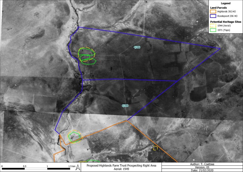
With regards to activities and work on archaeological and heritage sites this Act states that:

       “No person may alter or demolish any structure or part of a structure which is older than 60 years without a permit
       issued by the relevant provincial heritage resources authority.” (34. [1] 1999:58)

       and

       “No person may, without a permit issued by the responsible heritage resources authority:

       (a)    destroy, damage, excavate, alter, deface or otherwise disturb any archaeological or palaeontological site
              or any meteorite;

       (b)    destroy, damage, excavate, remove from its original position, collect or own any archaeological or
              palaeontological material or object or any meteorite;

       (c)    trade in, sell for private gain, export or attempt to export from the Republic any category of archaeological
              or palaeontological material or object, or any meteorite; or

       (d)    bring onto or use at an archaeological or palaeontological site any excavation equipment or any equipment
              which assist in the detection or recovery of metals or archaeological and palaeontological material or
              objects, or use such equipment for the recovery of meteorites.”(35. [4] 1999:58)

       and

       “No person may, without a permit issued by SAHRA or a provincial heritage resources authority:

       (a)    destroy, damage, alter, exhume or remove from its original position or otherwise disturb the grave of a
              victim of conflict, or any burial ground or part thereof which contains such graves;

       (b)    destroy, damage, alter, exhume, remove from its original position or otherwise disturb any grave or burial
              ground older than 60 years which is situated outside a formal cemetery administered by a local authority;

       (c)    bring onto or use at a burial ground or grave referred to in paragraph (a) or (b) and excavation equipment,
              or any equipment which assists in the detection or recovery of metals.” (36. [3] 1999:60)

       On the development of any area the gazette states that:

       “…any person who intends to undertake a development categorised as:

       (a)    the construction of a road, wall, power line, pipeline, canal or other similar form of linear development or
              barrier exceeding 300m in length;

       (b)    the construction of a bridge or similar structure exceeding 50m in length;

Tobias Coetzee ©
HighlandsFarmTrust_2202201
February 2020
                                                                                                                  10
(c) any development or other activity which will change the character of a site-
i. exceeding 5000m² in extent; or
ii. involving three or more existing erven or subdivisions thereof; or
iii. involving three or more erven or divisions thereof which have been consolidated within the past five
years; or
iv. the costs of which will exceed a sum set in terms of regulations by SAHRA or a provincial heritage
resources authority;
(d) the re-zoning of a site exceeding 10000m² in extent; or
(e) any other category of development provided for in regulations by SAHRA or a provincial heritage resources
authority, must at the very earliest stages of initiating such a development, notify the responsible heritage
resources authority and furnish it with details regarding the location, nature and extent of the proposed
development.” (38. [1] 1999:62-64)
and
“The responsible heritage resources authority must specify the information to be provided in a report required in
terms of subsection (2)(a): Provided that the following must be included:
(a) The identification and mapping of all heritage resources in the area affected;
(b) an assessment of the significance of such resources in terms of the heritage assessment criteria set out
in section 6(2) or prescribed under section 7;
(c) an assessment of the impact of the development on such heritage resources;
(d) an evaluation of the impact of the development on heritage resources relative to the sustainable social and
economic benefits to be derived from the development;
(e) the results of consultation with communities affected by the proposed development and other interested
parties regarding the impact of the development on heritage resources;
(f) if heritage resources will be adversely affected by the proposed development, the consideration of
alternatives; and
(g) plans for mitigation of any adverse effects during and after the completion of the proposed development.”
(38. [3] 1999:64)
Tobias Coetzee ©
HighlandsFarmTrust_2202201
February 2020
11Human Tissue Act and Ordinance 7 of 1925
The Human Tissues Act (65 of 1983) and Ordinance on the Removal of Graves and Dead Bodies (Ordinance 7
of 1925) protects graves younger than 60 years. These fall under the jurisdiction of the National Department of
Health and the Provincial Health Departments. Approval for the exhumation and re-burial must be obtained from
the relevant Provincial MEC as well as the relevant Local Authorities. Graves 60 years or older fall under the
jurisdiction of the National Heritage Resources Act as well as the Human Tissues Act, 1983.
2. Study Area and Project Description
2.1 Location & Physical Environment
The proposed Highlands Farm Trust prospecting project is situated approximately 4.5 km south of Wolmaransstad
across the following properties:
Table 1: Property name & coordinates
Map Reference
Property Portion Lat (y) Lon (x) Extent (ha)
(1:50 000)
Highlands 382 HO 0 2726AC & 2725BD -27.27441464 26.00392513 575
2726AA, 2726AC,
Roodepoort 206 HO 4/206 -27.24834224 26.00187218 239
2725BD & 2725BB
Roodepoort 206 HO 6/206 2726AC & 2725BD -27.25706725 25.99930600 179
The town of Makwassie is located about 2 km south of the proposed prospecting area, while Wolmaransstad is
located 4.5 km to the north and Leeudoringstad 23 km to the east. The study area falls within the Maquassi Hills
Local Municipality and the Dr Kenneth Kaunda District Municipality in the North West Province with the Free State
border located 30 km to the southeast. The R505 secondary road runs in a NNW-SSE direction about 1.5 km to
the west of the proposed prospecting area, while the N12 national road runs NE-SW through Wolmaransstad.
In terms of vegetation, the eastern section of the study area falls within Kimberley Thornveld, while the western
section falls within Klerksdorp Thornveld. Kimberley Thornveld belongs to the Savanna Biome and the Eastern
Kalahari Bushveld Bioregion, while Klerksdorp Thornveld belongs to the Grassland Biome and Dry Highveld
Grassland Bioregion.
According to Mucina & Rutherfords (2006), Kimberley Thornveld has a conservation status of least threatened
with a conservation target of 16%. Only about 2% is statutorily conserved in the Vaalbos National Park, as well
as in the Sandveld, Bloemhof Dam and S.A. Lombard Nature Reserves. About 18% has been transformed mostly
by cultivation. Erosion is considered to be low and the general associated activities are cattle farming and game
ranching. Kimberley Thornveld occurs mostly in the Kimberley, Hartswater, Bloemhof and Hoopstad districts, as
Tobias Coetzee ©
HighlandsFarmTrust_2202201
February 2020
12well as substantial parts of the Warrenton, Christiana, Taung, Boshof and to some extent the Barkly West districts.
Klerksdorp Thornveld occurs in two regions in the North West Province: One area is located in the vicinity of
Wolmaransstad, Ottosdal and Hartbees-fontein, while the other stretches from Botsolano Game Park north of
Mafikeng to the vicinity of Madibogo in the south. Klerksdorp Thornveld is considered vulnerable with a
conservation target of 24%. Only about 2.5% is conserved in the statutory in the Mafikeng Game Reserve, private
Botsolano Game Park and Faan Meintjes Nature Reserve, while about a third has been transformed by cultivation
and urban sprawl. Because this vegetation unit has a high grazing capacity, overutilization and degradation is
common (Mucina & Rutherfords 2006).
The average elevation for Kimberley Thornveld varies between 1050 and 1400 MASL, while Klerksdorp Thornveld
ranges between 1260 and 1580 MASL. The average elevation for the proposed prospecting area is 1340 MASL
and generally slopes form the slightly more elevated eastern section towards the river along the western boundary.
The study area falls within the summer rainfall region and the average annual rainfall is roughly 391 mm per year.
The average maximum temperature for the study area ranges from 17.6 ºC in June to 30 ºC in January. The
lowest temperatures occur during July when an average of 0 ºC is reached during the night (SA Explorer accessed
21/02/2020).
The study area falls within the C25D Quaternary Catchment within the Middle Vaal Water Management Area. The
closest perennial river to the study area is the Makwassiespruit that forms the western boundary of Portion 4 of
the Farm Roodepoort 206 HO and partially intersects Portion 6 of the Farm Roodepoort 206 HO and the Farm
Highlands 392 HO. It should also be noted that several dry streams are associated with the study area, notably
Portion 6/206 and the Farm Highlands 392 HO. These dry streams occur in an east-west direction and most likely
drain surface runoff into the Makwassiespruit.
2.2 Project description
The area demarcated for the prospecting of alluvial diamonds and diamonds in general covers about 980 ha
(Figures 2 - 4). It is envisaged that the exploration/prospecting programme will include a site visit and desktop
studies (non-invasive), the digging of test pits and bulk sampling (invasive), analysis and Geological Modelling
and Resource Estimation (non-invasive) over a phased 60-month period. Phases 1 and 2 (3 months) will consist
of non-invasive field mapping and desktop studies of prospecting literature. Phases 3 and 4 (57 months) will
consist of the digging of test pits as well as bulk sampling and washing and screening of gravel deposits aimed at
establishing a measured resource and will include logging, sampling, analysis and rehabilitation of excavations
(Terra Africa 2019).
Tobias Coetzee ©
HighlandsFarmTrust_2202201
February 2020
13Details regarding the proposed prospecting according to the Prospecting Work Programme are outlined
below:
Phase 1
A site visit will be conducted within 3 months after execution of the prospecting right.
The information obtained from the site visit will be studied during phase 2 (desktop studies) to determine where
phase 3 (pitting) will start.
Technical Support:
Geologist: Ian Snyders and / or Kuziva Chisi
Phase 2
Desktop studies will be undertaken after the site investigation has been done. The target areas will be determined.
It will also be determined if any infrastructure need to be built. Potential problems in the project will also be
addressed during this phase.
Technical Support:
Geologist: Ian Snyders and / or Kuziva Chisi
Phase 3
The testing pits will concentrate on the areas where the outcrops anticipated gravel potential.
A 30-ton excavator will be used to make test pits.
The pits will be 2m x 3m x +/- 4m in order to determine the depth and boundaries of the gravel. The boundaries
will be surveyed and mapped to determine where the bulk sampling will take place.
Each pit will be closed before moving to the next one.
Technical Support:
Geologist: Ian Snyders and / or Kuziva Chisi
Engineer: Noel Botha
Tobias Coetzee ©
HighlandsFarmTrust_2202201
February 2020
14Phase 4
A bulk sample to a total of 12000 m³ will be taken, consisting of trenches 10 x 30 x 4m.
1. The topsoil will be removed with an excavator and stored on a separate stockpile for rehabilitation purposes.
2. The overburden will be stripped and placed on the side of the excavation.
3. The gravel will be removed with an excavator and transported with a frond-end loader to the washing plant
consisting of a double 16-foot rotary pan.
4. The puddle is washed directly back into the excavation.
5. The rough out of the pan will be directly put back into the excavations.
6. The concentrate out of the pan will be sorted with a sortex where diamonds will be recovered and the grade
of the prospecting area determined.
Technical Support:
Geologist: Ian Snyders and / or Kuziva Chisi
Engineer: Noel Botha
Phase 5
All data will be processed to determine the diamond bearing resource on the property.
The data will be evaluated to determine if an application for a Mining Right or Mining Permit should be lodged.
Technical Support:
Geologist: Ian Snyders and / or Kuziva Chisi
Tobias Coetzee ©
HighlandsFarmTrust_2202201
February 2020
15Figure 2: Segments of SA 1: 50 000 2725 BB, 2725 BD, 2726 AA & 2726 AC indicating the study area. Tobias Coetzee © HighlandsFarmTrust_2202201 February 2020 16
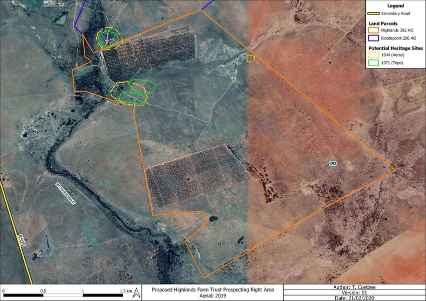
Figure 3: Proposed Highlands 392 HO section on an aerial backdrop.

Tobias Coetzee ©
HighlandsFarmTrust_2202201
February 2020                                                                        17
Figure 4: Proposed Roodepoort 206 HO section on an aerial backdrop.

Tobias Coetzee ©
HighlandsFarmTrust_2202201
February 2020                                                                         18
3.     Archaeological Background
       Southern African archaeology is broadly divided into the Early, Middle and Later Stone Ages; Early, Middle and
       Later Iron Ages; and Historical or Colonial Periods. This section of the report provides a general background to
       archaeology in South Africa.

3.1 The Stone Age
       The earliest stone tool industry, the Oldowan, was developed by early human ancestors which were the earliest
       members of the genus Homo, such as Homo habilis, around 2.6 million years ago. It comprises tools such as
       cobble cores and pebble choppers (Toth & Schick 2007). Archaeologists suggest these stone tools are the earliest
       direct evidence for culture in southern Africa (Clarke & Kuman 2000). The advent of culture indicates the advent
       of more cognitively modern hominins (Mitchell 2002: 56, 57).

       The Acheulean industry completely replaced the Oldowan industry. The Acheulian industry was first developed
       by Homo ergaster between 1.8 to 1.65 million years ago and lasted until around 300 000 years ago.
       Archaeological evidence from this period is also found at Swartkrans, Kromdraai and Sterkfontein. The most
       typical tools of the ESA are handaxes, cleavers, choppers and spheroids. Although hominins seemingly used
       handaxes often, scholars disagree about their use. There are no indications of hafting, and some artefacts are
       far too large for it. Hominins likely used choppers and scrapers for skinning and butchering scavenged animals
       and often obtained sharp ended sticks for digging up edible roots. Presumably, early humans used wooden
       spears as early as 5 million years ago to hunt small animals.

       Middle Stone Age artefacts started appearing about 250 000 years ago and replaced the larger Early Stone Age
       bifaces, handaxes and cleavers with smaller flake industries consisting of scrapers, points and blades. These
       artefacts roughly fall in the 40-100 mm size range and were, in some cases, attached to handles, indicating a
       significant technical advance. The first Homo sapiens species also emerged during this period. Associated sites
       are Klasies River Mouth, Blombos Cave and Border Cave (Deacon & Deacon 1999).

       Although the transition from the Middle Stone Age to the Later Stone Age did not occur simultaneously across the
       whole of southern Africa, the Later Stone Age ranges from about 20 000 to 2000 years ago. Stone tools from this
       period are generally smaller, but were used to do the same job as those from previous periods; only in a different,
       more efficient way. The Later Stone Age is associated with: rock art, smaller stone tools (microliths), bows and
       arrows, bored stones, grooved stones, polished bone tools, earthenware pottery and beads. Examples of Later
       Stone Age sites are Nelson Bay Cave, Rose Cottage Cave and Boomplaas Cave (Deacon & Deacon 1999).
       These artefacts are often associated with rocky outcrops or water sources. Figures 5 – 7 below shows examples
       of stone tools often associated with the ESA, MSA and LSA of southern Africa. The LSA site, Matlwase, is located
       just south of Wolmaransstad in the vicinity of the study area (Korsman et al. 1998: 95).

Tobias Coetzee ©
HighlandsFarmTrust_2202201
February 2020
                                                                                                                 19
Figure 5: LSA scrapers (Klein 1984).
Figure 6: MSA artefacts from Howiesons Poort (Volman 1984).
Figure 7: LSA scrapers (Klein 1984).
3.2 The Iron Age & Historical Period
The Early Iron Age marks the movement of farming communities into South Africa in the first millennium AD, or
around 2500 years ago (Mitchell 2002:259, 260). These groups were agro-pastoralist communities that settled in
the vicinity of water in order to provide subsistence for their cattle and crops. Archaeological evidence from Early
Iron Age sites is mostly artefacts in the form of ceramic assemblages. The origins and archaeological identities
of this period are largely based upon ceramic typologies. Some scholars classify Early Iron Age ceramic traditions
into different “streams” or “trends” in pot types and decoration, which emerged over time in southern Africa. These
“streams” are identified as the Kwale Branch (east), the Nkope Branch (central) and the Kalundu Branch (west).
Early Iron Age ceramics typically display features such as large and prominent inverted rims, large neck areas
and fine elaborate decorations. This period continued until the end of the first millennium AD (Mitchell 2002;
Huffman 2007). Some well-known Early Iron Age sites include the Lydenburg Heads in Mpumalanga, Happy Rest
in the Limpopo Province and Mzonjani in Kwa-Zulu Natal.
The Middle Iron Age roughly stretches from AD 900 to 1300 and marks the origins of the Zimbabwe culture.
During this period cattle herding appeared to play an increasingly important role in society. However, it was
proved that cattle remained an important source of wealth throughout the Iron Age. An important shift in the Iron
Tobias Coetzee ©
HighlandsFarmTrust_2202201
February 2020
20Age of southern Africa took place in the Shashe-Limpopo basin during this period, namely the development of
class distinction and sacred leadership. The Zimbabwe culture can be divided into three periods based on certain
capitals. Mapungubwe, the first period, dates from AD 1220 to 1300, Great Zimbabwe from AD 1300 to 1450,
and Khami from AD 1450 to 1820 (Huffman 2007: 361, 362).
The Late Iron Age roughly dates from AD 1300 to 1840. It is generally accepted that Great Zimbabwe replaced
Mapungubwe. Some characteristics include a greater focus on economic growth and the increased importance
of trade. Specialisation in terms of natural resources also started to play a role, as can be seen from the
distribution of iron slag which tend to occur only in certain localities compared to a wide distribution during earlier
times. It was also during the Late Iron Age that different areas of South Africa were populated, such as the interior
of KwaZulu Natal, the Free State, the Gauteng Highveld and the Transkei. Another characteristic is the increased
use of stone as building material. Some artefacts associated with this period are knife-blades, hoes, adzes, awls,
other metal objects as well as bone tools and grinding stones.
The Rolong, who split into 4 groups during the 18th Century, occupied the area between the Vaal River and Molopo
River prior to the “difaqane”. According to Ratlou-Rolong accounts during the Bloemhof Commission of 1871,
they were traditionally associated with the area from Bloemhof to Khunwana and from there to the Setlagole and
the Molopo. It is also known that the Seleka-Rolong under Sehunelo attacked the Ratlou-Rolong just prior to the
“difaqane” at Thabeng on the farm Buisfontein near Schoonspruit, from where they settled at Makwassiespruit. It
is at Makwassiespruit where the missionary, S. Broadbent, met with them. The ruins of his home are located ENE
of Wolmaransstad near the Makwassiespruit. Another group, the Tsatsing of Thamaga, occupied the area in the
vicinity of present day Schweizer-Reneke and Delareyville in 1820 (Bergh 1998b: 106).
The Historical period mainly deals with Europe’s discovery, settlement and impact on southern Africa. Some
topics covered by the Historical period include Dutch settlement in the Western Cape, early mission stations,
Voortrekker routes and the Anglo Boer War. This time period also saw the compilation of early maps by
missionaries, explorers, military personnel, etc.
According to Bulpin (1986: 716), a trader named Thomas Leask established a store in 1876 on the site
Wolmaransstad would later be established. Accordingly, the town was proclaimed on 16 February 1891 and was
named after J.M.A Wolmarans, a member of the Executive Council of the South African Republic. The reason for
the establishment of the town was to establish a centre for the farming community with maize as principal local
product. It is also noted that the Makwassiespruit got its name from number of wild spearmint bushes growing
along the banks of the river. According to Bergh (1998a: 12), some of the earliest travellers to the Wolmaransstad
area include De Buys in 1821 and 1825, Broadbent and Hodgson in 1823, and Hodgson & Archbell in 1826.
Tobias Coetzee ©
HighlandsFarmTrust_2202201
February 2020
213.3 Previous Heritage Studies
Wolmaransstad Extension 17 Township Development
A phase 1 HIA was done for the Wolmaransstad Extension 17 Township Development, which is located about 5
km northwest of the study area on the Remaining Extent of Portion 2 of the Farm Wolmaransstad Town &
Townlands 184 HO. The Township development is located directly west of the town of Wolmaransstad. The HIA
noted that the area has been disturbed by agricultural activities, a quarry, an old SANDF shooting range, and
informal dumping. A total of 17 sites were recorded during the survey and include possible graves, individual
stone tools, farm related structures, the shooting range and others. It was also noted that the majority of the sites
were not significant from a heritage perspective and that development could continue (Pelser 2015).
Rulaganyang Extension 2 Township Establishment
The HIA survey done for the development of the Rulaganyang Extension 2 Township on a portion of the remaining
extent of Portion 11 of the Farm Leeuwfontein 29 HO near Witpoort, recorded no sites on the specific land parcel.
However, it was noted that a number of known cultural heritage sites exist in the larger area. The Rulaganyang
Extension 2 Township is located approximately 13 km northeast of the proposed prospecting site (Pelser 2017a).
Lebaleng Extension 6 Township Establishment
The HIA survey done for the development of the Lebaleng Extension 6 Township on a portion of the Remaining
Extent of Portion 8 of the farm Oersonskraal 207 HO in Maquassi, recorded no sites on the specific land parcel.
However, it was noted that a number of known cultural heritage sites exist in the larger area. The Lebaleng
Extension 6 Township is located approximately 4 km southwest of the proposed prospecting site (Pelser 2017b).
4. Evaluation
The significance of an archaeological site is based on the amount of deposit, the integrity of the context, the kind
of deposit and the potential to help answer present research questions. Historical structures are defined by
Section 34 of the National Heritage Resources Act, 1999, while other historical and cultural significant sites, places
and features, are generally determined by community preferences.
A fundamental aspect in the conservation of a heritage resource relates to whether the sustainable social and
economic benefits of a proposed development outweigh the conservation issues at stake. There are many
aspects that must be taken into consideration when determining significance, such as rarity, national significance,
scientific importance, cultural and religious significance, and not least, community preferences. When, for
whatever reason the protection of a heritage site is not deemed necessary or practical, its research potential must
be assessed and if appropriate mitigated in order to gain data / information which would otherwise be lost. Such
sites must be adequately recorded and sampled before being destroyed.
Tobias Coetzee ©
HighlandsFarmTrust_2202201
February 2020
225. Statement of Significance & Recommendations
5.1 Statement of significance
The study area: The Farm Highlands 392 HO and Portions 4 and 6 of the Farm Roodepoort 206 HO,
Wolmaransstad, North West
As can be seen from previous research done in the area, the general region is significant from a heritage
perspective. Heritage sites are likely to include MSA/LSA material, cemeteries/burial sites and historical
structures. Since heritage sites, such as burial sites, are not always clearly identifiable due to disturbed/removed
surface features, care must be exercised when prospecting.
The Appendix A figures indicate the study area on a 1964 topographical map, as well as on 1944, 1949, 1961
and 1970 aerial images. According to the 1964 topographical map (Appendix A: Figure 8), kraals and buildings
are indicated near the north-western corner of the Farm Highlands 392 HO (Previously part of Oersonskraal 207
HO), the southern areas of Portion 6/206, and the western section of Portion 4/206. Several sections are also
shown to be cultivated land.
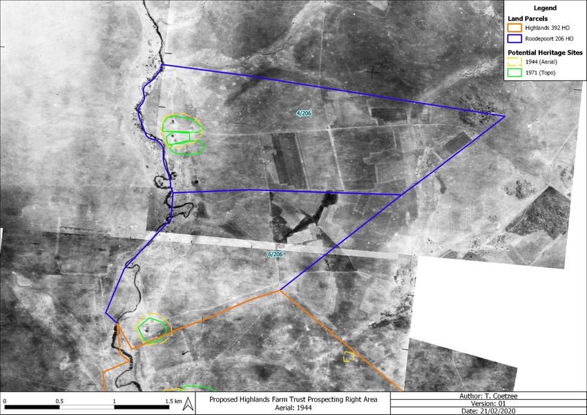
When the1944 aerial images are consulted (Appendix A: Figures 9 & 10), structures are visible in the same
locations as the 1964 topographical map, with the exception of a possible structure along the eastern border of
the Farm Highlands 392 HO. To a large extent, cultivated fields cover the same areas as indicated on the 1964
topographical map.
The 1949 aerial images (Appendix A: Figures 11 & 12), appear similar to the 1944 aerial images in terms of
visible structures, with the exception of the possible structure along the eastern boundary of the Farm Highlands
392 HO. This suggests that the structure was either demolished, or the presence of an inconsistency on the aerial
photograph. It also appears that more fields were cultivated between 1944 and 1949 on the farm Highlands 392
HO.
The 1961 aerial images (Appendix A: Figures 13 & 14) show that one of the structures associated with each of
the built-up areas on Portions 4 & 6 of the Farm Roodepoort 206 HO appear to have been demolished, while the
structures on the Farm Highlands 392 HO appear largely the same.
The structures on Portion 4/206 appear to be partially demolished on the 1970 aerial image, as well as one of the
buildings on the Farm Highlands 392 HO. The structures on Portion 6/206 appear to be the same, with the
possible addition of a few buildings in close proximity of the existing building (Appendix A: Figure 15 & 16).
Tobias Coetzee ©
HighlandsFarmTrust_2202201
February 2020
23Based on the inspection of the historical aerial imagery and topographical maps, 4 potentially sensitive areas were
identified and are indicated on Figure 4. The structures previously visible on Portion 4 of the Farm Roodepoort
206 HO appear to have completely been demolished, while buildings are still visible on Portion 6 of the same
parent farm. It is likely that some of the older buildings have been demolished and replaced by modern buildings,
but it is also possible that some of the historical buildings are still present. The structures previously visible on
the Farm Highlands 392 HO appear to have been demolished as well, as only the ruins of one building are visible
on recent aerial imagery,
The areas indicated as ‘Potential Heritage Sites’ on Figure 4 are associated with potentially significant cultural
material, either surface or subsurface. These areas may contain buildings/material that exceed 60 years of age
and are therefore protected under the NHRA (25 of 1999). It should be kept in mind that the ‘Potential Sites’ areas
might not be limited by the indicated boundaries.
Tobias Coetzee ©
HighlandsFarmTrust_2202201
February 2020
245.2 Recommendations
The following recommendations are made in order to avoid the destruction of heritage remains on the areas
demarcated for prospecting:
It is recommended that the demarcated ‘Potential Heritage Sites’ areas on Figure 4 be avoided by the
proposed prospecting activities due to the possible presence of surface/subsurface culturally significant
material. Should this not be possible, a qualified archaeologist should be present on-site during prospecting
in order to limit potential impact on heritage resources and provide the required input.
It is advised that a qualified archaeologist be contacted whenever uncertainty regarding potential heritage
remains are encountered.
Prospecting should not take place in the vicinity of stone cairns, potential burial sites, stone-walling, building
ruins or any other heritage material or structures.
Should the prospecting outcome result in further development or construction, a full Phase 1 Archaeological
Impact Assessment must be conducted on the affected area if triggered. Also, a full Phase 1 AIA must be
done should the cumulative impact of the proposed prospecting exceed 0.5 ha.
Because archaeological artefacts generally occur below surface, the possibility exists that culturally
significant material may be exposed during the prospecting phase, in which case all activities must be
suspended pending further archaeological investigations by a qualified archaeologist. Also, should skeletal
remains be exposed, all activities must be suspended and the relevant heritage resources authority
contacted (See National Heritage Resources Act, 25 of 1999 section 36 (6)).
From a heritage point of view, prospecting may proceed on the demarcated portions, subject to the
abovementioned conditions and recommendations.
Tobias Coetzee ©
HighlandsFarmTrust_2202201
February 2020
256. Addendum: Terminology
Archaeology:
The study of the human past through its material remains.
Artefact:
Any portable object used, modified, or made by humans; e.g. pottery and metal objects.
Assemblage:
A group of artefacts occurring together at a particular time and place, and representing the sum of human activities.
Context:
An artefact’s context usually consist of its immediate matrix (the material surrounding it e.g. gravel, clay or sand), its
provenience (horizontal and vertical position within the matrix), and its association with other artefacts (occurrence together
with other archaeological remains, usually in the same matrix).
Cultural Resource Management (CRM):
The safeguarding of the archaeological heritage through the protection of sites and through selvage archaeology (rescue
archaeology), generally within the framework of legislation designed to safeguard the past.
Excavation:
The principal method of data acquisition in archaeology, involving the systematic uncovering of archaeological remains
through the removal of the deposits of soil and other material covering and accompanying it.
Feature:
An irremovable artefact; e.g. hearths or architectural elements.
Ground Reconnaissance:
A collective name for a wide variety of methods for identifying individual archaeological sites, including consultation of
documentary sources, place-name evidence, local folklore, and legend, but primarily actual fieldwork.
Matrix:
The physical material within which artefacts is embedded or supported, i.e. the material surrounding it e.g. gravel, clay or
sand.
Phase 1 Assessments:
Scoping surveys to establish the presence of and to evaluate heritage resources in a given area.
Phase 2 Assessments:
In-depth culture resources management studies which could include major archaeological excavations, detailed site
surveys and mapping / plans of sites, including historical / architectural structures and features. Alternatively, the
sampling of sites by collecting material, small test pit excavations or auger sampling is required.
Sensitive:
Often refers to graves and burial sites although not necessarily a heritage place, as well as ideologically significant sites
such as ritual / religious places. Sensitive may also refer to an entire landscape / area known for its significant heritage
remains.
Tobias Coetzee ©
HighlandsFarmTrust_2202201
February 2020
26Site:
A distinct spatial clustering of artefacts, features, structures, and organic and environmental remains, as the residue of
human activity.
Surface survey:
There are two kinds: (1) unsystematic and (2) systematic. The former involves field walking, i.e. scanning the ground
along one’s path and recording the location of artefacts and surface features. Systematic survey by comparison is less
subjective and involves a grid system, such that the survey area is divided into sectors and these are walked ally, thus
making the recording of finds more accurate.
7. References
Bergh, J.S. 1998a. Geskiedenisatlas Van Suid-Afrika: Die Vier Noordelike Provinsies. Pretoria: J. L. van Schaik
Uitgewers.
Bergh, J.S. 1998b. Swart gemeenskappe teen die begin van die 19de eeu. In: Bergh, J. (ed.) Geskiedenisatlas Van
Suid-Afrika: Die Vier Noordelike Provinsies: 105-109. Pretoria: J. L. van Schaik Uitgewers.
Bulpin, T.V. 1986. Discovering Southern Africa. Natal: Interpak
Clarke, R.J. & Kuman, K. 2000. The Sterkfontein Caves Palaeontological and Archaeological Sites. Johannesburg:
University of the Witwatersrand.
Deacon, H. & Deacon, J. 1999. Human beginnings in South Africa. Cape Town: David Philip.
Huffman, T.N. 2007. Handbook to the Iron Age. Pietermaritzburg: UKZN Press.
Klein, R. G. (ed.) 1984. South African prehistory and paleoenvironments. Rotterdam: Balkema
Korsman, S.A., Van Der Ryst, M.M. & Meyer, A. 1998. Die Vroegste Inwoners. In: Bergh, J. (ed.) Geskiedenisatlas Van
Suid-Afrika: Die Vier Noordelike Provinsies: 93-102. Pretoria: J. L. van Schaik Uitgewers.
Mitchell, P. 2002. The archaeology of southern Africa. Cambridge: Cambridge University Press.
Mucina, L. & Rutherford, M. C. 2006. The Vegetation of South Africa, Lesotho and Swaziland. Strelitzia 19. South African
National Biodiversity Institute, Pretoria.
Tobias Coetzee ©
HighlandsFarmTrust_2202201
February 2020
27Pelser, A.J. 2015. Phase 1 HIA report for the proposed Wolmaransstad Extension 17 Township Development on the
remaining extent of portion 2 of the farm Wolmaransstad Town and Townlands 184HO, Wolmaransstad, North West
Province. Pretoria: APAC
Pelser, A.J. 2017a. Report on a Phase 1 Heritage Impact Assessment for the proposed Rulaganyang Extension 2
Township establishment on a portion of the remaining extent of portion 11 (a portion of portion 1) of the farm
Leeuwfontein 29HO near Witpoort, North West Province. Pretoria: APAC
Pelser, A.J. 2017a. Report on a Phase 1 Heritage Assessment for the proposed LebalengExtnesion 6 Township
establishment on the remaining extent of portion 8 of the farm Oersonskraal 207HO in Maquassi, North West
Province. Pretoria: APAC
Sa Explorer. Wolmaransstad Climate. http://www.saexplorer.co.za/south-africa/climate/wolmaransstad_climate.asp.
Accessed 21-02-2020.
Terra Africa, 2019. Background information document for the prospecting right application over various portions of land
in the magisterial district of Maquassi Hills, North West Province. Ottodal: Terra Africa
Toth, N. & Schick, K. 2007. Handbook of paleoanthropology. Berlin: Springer.
Volman, T. P. 1984. Early Prehistory of southern Africa. In: Klein, R. G. (ed.) Southern African prehistory and
paleoenvironments. Rotterdam: Balkema.
Human Tissue Act No. 65 of 1983, Government Gazette, Cape Town
National Heritage Resource Act No.25 of 1999, Government Gazette, Cape Town
Removal of Graves and Dead Bodies Ordinance No. 7 of 1925, Government Gazette, Cape Town
Tobias Coetzee ©
HighlandsFarmTrust_2202201
February 2020
28Appendix A: Historical Topographical Maps & Aerial Imagery Tobias Coetzee © HighlandsFarmTrust_2202201 February 2020 A
Figure 8: Segments of 1964-1971 SA 1: 50 000 2725 BB, 2725 BD, 2726 AA & 2726 AC indicating the study area.

Tobias Coetzee ©
HighlandsFarmTrust_2202201
February 2020                                                                                                                 B
Figure 9: 1944 Aerial Image indicating the Highlands 392 HO section.

Tobias Coetzee ©
HighlandsFarmTrust_2202201
February 2020                                                                          C
Figure 10: 1944 Aerial Image indicating the Roodepoort 206 HO section.

Tobias Coetzee ©
HighlandsFarmTrust_2202201
February 2020                                                                            D
Figure 11: 1949 Aerial Image indicating the Highlands 392 HO section.

Tobias Coetzee ©
HighlandsFarmTrust_2202201
February 2020                                                                           E
Figure 12: 1949 Aerial Image indicating the Roodepoort 206 HO section.

Tobias Coetzee ©
HighlandsFarmTrust_2202201
February 2020                                                                            F
Figure 13: 1961 Aerial Image indicating the Highlands 392 HO section.

Tobias Coetzee ©
HighlandsFarmTrust_2202201
February 2020                                                                           G
Figure 14: 1961 Aerial Image indicating the Roodepoort 206 HO section.

Tobias Coetzee ©
HighlandsFarmTrust_2202201
February 2020                                                                            H
Figure 15: 1970 Aerial Image indicating the Highlands 392 HO section.
Tobias Coetzee ©
HighlandsFarmTrust_2202201
February 2020                                                                           I
Figure 16: 1970 Aerial Image indicating the Roodepoort 206 HO section.

Tobias Coetzee ©
HighlandsFarmTrust_2202201
February 2020                                                                            J
You can also read