Assessment of Geotourism Values and Ecological Status of Mines in Kopaonik Mountain (Serbia) - MDPI
←
→
Page content transcription
If your browser does not render page correctly, please read the page content below
Article

Assessment of Geotourism Values and Ecological
Status of Mines in Kopaonik Mountain (Serbia)
Danijela Vukoičić 1,*, Radomir Ivanović 1, Dragan Radovanović 1, Jovan Dragojlović 1,
Nataša Martić‐Bursać 2, Marko Ivanović 1 and Dušan Ristić 1
 1 University in Priština‐Kosovska Mitrovica, Faculty of Sciences, Lole Ribara 29,
 38220 Kosovska Mitrovica, Serbia; radomir.ivanovic@pr.ac.rs (R.I.); dragan.radovanovic@pr.ac.rs (D.R.);
 jovan.dragojlovic@pr.ac.rs (J.D.); marko.ivanovic@pr.ac.rs (M.I.); dusan.ristic@pr.ac.rs (D.R.)
 2 Faculty of Nature and Mathematics, University of Niš, Višegradska 33, 18000 Niš, Serbia;

 natasamarticbursac@gmail.com
 * Correspondence: danijela.vukoicic@pr.ac.rs; Tel.: +381‐66‐800‐6426

 Received: 30 January 2020; Accepted: 6 March 2020; Published: 17 March 2020

 Abstract: Abandoned mines can pose a major environmental hazard. At the beginning of the 21st
 century, significant steps were taken all around the world in order to protect these historically
 valuable complexes, and the mining heritage was recognized as a potential for the development of
 alternative tourism. This exploration covers mines in the Kopaonik Mountain area. Mining on this
 mountain began in ancient times. It has developed throughout history, and today only one mine is
 active. Three abandoned (Gvozdac, Suvo Rudište and Raičeva Gora) and one active mine (Belo
 Brdo‐Zaplanina) are the subject of research. The basic aim of the research is twofold. The estimation
 of geo‐tourist values was performed using the Geosite Assessment Model (GAM), and the ecological
 status assessment WAS performed according to the standard model based on negative and positive
 values. Based on the applied methods, it was concluded that mines (geosites) have a high level of
 natural characteristics, and that differences between geosites are evident in tourist values. The
 reason for this is insufficient tourist affirmation and the insufficient availability of tourist
 infrastructure. With the ecological status, positive values were observed on the geosites, which also
 differ from one (Raičeva Gora) to 15 points (Gvozdac). In the end, the results obtained are of great
 scientific importance, and their direct application is in the development of the Tourism
 Development Strategy in the Kopaonik area.

 Keywords: mining heritage; geosites; geotourism value; ecological status; environment; Kopaonik;
 Serbia

1. Introduction
 Human activities directly and indirectly affect the environment through their activities [1]. Thus,
through a direct or indirect combination of human activities and natural forces, numerous landscapes
have been created [1,2]. The anthropogenic activities significantly change the landscape and they can
be implemented within the framework of sustainable management and conservation of
geomorphological heritage, which is confirmed by the study by Kubalikova et al. [3]. The results of
the anthropogenic assessment in this study may serve the purpose of landscaping and assist in
arguments for the conservation of particular localities. Baczinska et al. [4] also performed the
evaluation of landscape attractiveness, on the example of abandoned quarries.
 Mining activity and related mineral processing are generally considered among the major
anthropogenic sources of potentially harmful elements and other contaminants in the environment
[5,6]. The accelerated mass closure of unprofitable mines without proper environmental impact

Minerals 2020, 10, 269; doi:10.3390/min10030269 www.mdpi.com/journal/minerals
Minerals 2020, 10, 269 2 of 24

assessments and scientific justification has multi‐component environmental impacts [7]. The extent
of the adverse impacts of mine closures on the landscape and the living world are variable and reflect
the extent of environmental management measures. Decommissioned mining sites represent the
usual case studies in environmental sciences [8], especially regarding the dispersion and geochemical
mobility of potentially harmful elements which can cause contamination of soils [9,10], sediments
[11,12], waters [6,13] and vegetation [14,15]. The main problems associated with mine closure are
erosion and soil pollution [16], surface discharges, aquifer collapse, deterioration of natural water
quality [17,18] and waste piles [19,20]. Minic acid water can be toxic; its chemistry reflects its mineral
sulfide content [17,21–24]. Acid mine drainage (AMD) is a worldwide environmental problem
representing a primary source of contamination by heavy metals in both active and abandoned
mining areas [25–29]. The release of mine acid is a complex process triggered by the oxidation of Fe
(II) sulfide, mainly pyrite (FeS2), in contact with water and atmospheric oxygen. The oxidation of
pyrite creates acidic waters rich in iron and sulfate that are able to dissolve other sulfides (e.g.,
sphalerite (ZnS), chalcopyrite (CuFeS2), galena (PbS)) linked to pyrite, which are responsible for
releasing heavy metals such as Cd, Cu, Pb, and Zn in the resulting drainage waters. Bacterial activity
plays a key role in the acid mine drainage process by increasing the rate of pyrite oxidation and the
production of acid mine drainage [30]. The release of mine acid is mainly related to the disposal at
open landfills of sulfide rich ore (e.g., tailings) produced by ore processing activities, as well as the
exploitation of the mineralization of sulfide on precious and base metals through open pits and
underground mines [29].
 On the basis of the Law on Mining and Geological Surveys (Article 146) of the Republic of Serbia,
the Government determines the conditions, criteria, programming, procedure and manner of
performing the rehabilitation and reclamation of abandoned mines and mining facilities. Procedures
for rehabilitation and reclamation of abandoned mines and mining facilities are performed on the
basis of (Article 148): studies of the current situation, mining works and facilities; a project of
engineering–geological research in order to determine the technical and technological bases for the
design of the rehabilitation and recultivation projects; projects for rehabilitation and reclamation of
abandoned mines and mining facilities. The owner of the exploitation is obliged, during and after the
completion of the execution of the exploitation works, and within one year at the latest, upon the
completion of the works on the surfaces where the mining works have been completed, to recultivate
the land in accordance with the technical project of technical and biological reclamation, which is
integral part of the main or supplementary mining project (Article 153) [31].
 Surface mines and underground excavations can seriously damage the natural environment and
living organisms. As there are no precise data on the ecological status and exact locations of
abandoned mines, they pose a major environmental hazard. At the sites of abandoned ore fields from
underground pits and surface mines, mine waters are collected which directly affect the environment
by drainage. Such waters adversely affect the water quality of the basin and are a direct danger to
human health beyond the boundaries of the mine area for an extended period of time. The physical–
chemical characteristics of the deposited mining waste influence the process of land formation and
biodiversity. Mining areas are characterized by accelerated erosion processes that can significantly
affect change in the topographic surface and cause hazards such as floods, landslides and avalanches.
Traces of mining activity can also seriously affect the visual appearance of the area (abandoned
buildings and mining facilities for mineral processing, waste disposal sites, open pit excavations,
open pits, etc.). In addition to environmental impacts, all this causes economic damage to public and
private land.
 The remains of mining and the processing of mineral resources that are used to represent and
interpret the values and issues linked to the mining industry and mineworkers can, therefore, be
labelled as mining heritage [32–34]. It can be either material (pits, buildings, equipment, miners’
uniforms) or immaterial (procedures, miners’ habits, and traditions). The closure of mines brought
stagnation and economic transformation. When mining ceases, large contaminated areas require
specific treatment. It is important to conserve substantial elements of the heritage of mining, creating
a real mining heritage. These are the tasks of the conservation authorities and expert institutions.
Minerals 2020, 10, 269 3 of 24

Heritage protection is an important stage in the process and is determined by many conditions,
mostly set by laws or international conventions. With regard to the recognition of the mining heritage,
there is a question of how to present it and at the same time to interpret and pass it on in order to
preserve and cultivate its specific values and meanings. The origin of the mining heritage is seen as
a component of the area regeneration (economic and social) and it should be used appropriately.
Many museums, open‐air folk museums, and mines or galleries open to the public have come into
existence. However, the mining landscape itself can also be seen as a mining heritage. Mining tourism
is more focused on the remnants of mining activity and mining heritage; it can be considered as an
important process in the interpretation of mining heritage and serve as a source of employment even
after the end of mining.
 Interpretation of its tourism values can be presented as a type of geotourism [35]. Yet geotourism
partly differs from mining tourism in its geological and geomorphological focus [36]. Geotourism is
an abiotic parallel to ecotourism [37]. The roots of the geotourism concept come from the work of
Jenkins [38], while some later authors have linked geology to tourism [38–44]. Newsome and
Dowling [45] consider geotourism a form of tourism within the natural area that focuses specifically
on geology and relief, i.e., a form that promotes tourism at geosites. Geotourism is a process of
recognizing and giving wider significance to geo‐heritage objects that should lead to their better and
more efficient conservation, and its most important elements are measures of geo‐conservation
combined with tourism promotion [35,46–48].
 The main objectives of geotourism include promotion and protection of geoheritage throughout
tourism activities along with educational and interpretive elements in order to increase the awareness
of the wider public for conservation needs as well as sustainable development of the tourism industry
[49,50].
 Although Serbia occupies a small territory, in geological terms it is an extremely diverse and
complex area located at the junction of large geotectonic entities: the Dinarides, the Vardar Zone, the
Serbian–Macedonian Mass, the Carpatho‐Balkanides and the Pannonian Basin [51,52]. In the study
of geological material, certain phenomena and profiles are recognized as part of the natural heritage
that should be preserved because of their scientific, aesthetic, historical and other values. Generally,
there is a growing amount of geotourism research in Serbia. The northern [53,54], eastern [49,55–58]
and western parts of Serbia [59] are equally explored, while the Kopaonik and the Devil’s Town [60]
were explored in southeastern Serbia.
 This study will focus on the evaluation and revitalization of abandoned mines in Serbia, in the
area of Kopaonik Mountain. The primary objective of this research is twofold. The first is the
assessment of the geotourism values of the mines and the second is the assessment of the ecological
status and impact of the mines on the environment, while the ultimate goal is their revitalization and
rounding off of tourist offers in the area.

2. Materials and Methods

2.1. Study Area
 The Kopaonik Mountain (Serbia) was selected for the case study. The reason for the selection
lies in the fact that mining at Kopaonik began in ancient times. It has developed throughout history
and has survived to this day. Even its name is comprised of a word that denotes digging (Kopaonik
stems from the Serbian word ʺkopatiʺ which means ʺto digʺ) and silver ore (Venetian name
“montagna dell argento”, meaning silver mountain). Even more striking are the toponyms of local
settlements which are based on the words that denote ores (Suvo Rudište and Rudnica), silver
(Srebrenac), iron (Gvozdac) andlimestone elevations (Belo Brdo) [61].
 By 1990, 18 mines were being mined at the Kopaonik surface and mine shafts. Due to the closure
of all underground mines (as a result of the depletion of ore reserves and restrictions by the
proclaimed National Park regime) and, a little later, the surface mines (except the lead and zinc mines
Belo Brdo–Zaplanina), mining is not a significant economic activity today.
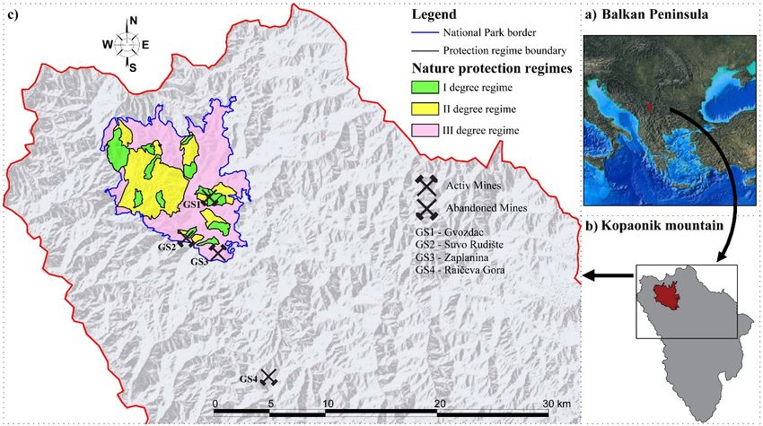
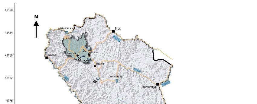
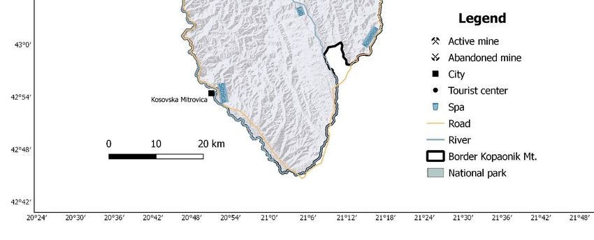
Minerals 2020, 10, 269 4 of 24

 Kopaonik Mountain, with an area of approximately 2750 km2, lies at the contact of central and
southern Serbia and represents the boundary between the Dinaric and Rhodope Mountain Systems.
It is surrounded by river valleys: Jošanica, Pločanska and Koznička in the north; the middle course
of Rasina and Blatašnica in the northeast; Toplica, Kosanica, Dubnica and Lab in the east; Lab in the
south and Sitnica and Ibar in the west [60]. The mountain stretches in the north, west, south and east
directions to a length of 80 km, reaching, in its middle part, a width of about 40 km [62,63]. In 1981,
an area of 11,810 ha was proclaimed Kopaonik National Park. The Kopaonik National Park is located
in the municipalities of Raška and Brus, and the protection zone also in the area of Leposavić
Municipality [64]. This research included the active Belo Brdo–Zaplanina mine in the Zaplanina area
and abandoned mines Gvozdac, Suvo Rudište and Raičeva Gora (Figure 1).

 Figure 1. Location map of Kopaonik Mountain.

 Three mines (Gvozdac, Suvo Rudište and Zaplanina) are located in the Kopaonik area, which
has been proclaimed as a National Park and nature reserve protected by the state of Serbia, while the
Raičeva Gora mine is outside the borders of the National Park (NP) and its protective zone (Figure
2). Gvozdac is located on the site of “Metođe”, which is in the regime of I degree (I zone) of nature
protection, while Suvo Rudište and Zaplanina are in the third zone of nature protection. The Belo
Brdo mine, which is not subject to exploration and is part of the Zaplanina–Belo Brdo mine system,
is located in the zone that represents the external protection (protective zone) of the Kopaonik NP.
Minerals 2020, 10, 269 5 of 24

 Figure 2. View of mines and protection zones in Kopaonik area.

 Mining was intensively carried out in Kopaonik in the XIV and XV centuries. Although the
exploitation of non‐ferrous and precious metals was occasionally interrupted, it lasted from Roman
times until the end of the XVII century, while in the XVIII and XIX centuries the exploitation of these
metals ceased and, on the other hand, the mining of iron developed. In all periods, mining was the
main or significant economic activity in the area [65].

2.2. Description of the Locality
 The mines explored are archeological sites that have significant geotourism value, but are also
the subject of numerous environmental issues in order to protect the Kopaonik NP and its protection
zone.
 Today, these mines represent valuable geoheritage sites where tourism can be developed. The
localities can be developed independently and in complementarity with other localities that are
protected by law as reserves or nature monuments in the area of Kopaonik National Park. The
development of tourism in these once economically important localities, settlements can bring
economic benefits and re‐empower them, since this is an economically and demographically
disadvantaged area.
 The Kopaonik massif belongs to the outer Vardar subzone and is located between the Drina‐
Ivanjica element in the west and the central Vardar subzone in the east. The base of the Kopaonik
massif is built by granodiorites (Oligocene), which project to the surface in the central part. In the
lower regions, above them lie a suite of Triassic and Paleozoic metamorphites, ophiolite melange and
ultramafites [66].
 Gvozdac (GS1) is a name for steep, almost vertical cliffs from porphyroid quartzmonzonite above
the canyon of the Gvozdačka river. It is located in the first zone of protection of the Metođe site,
within which there is a cave church (shrine) called Metođe. Metođe and Jelak form a unique whole,
as separate localities and degrees of nature protection. North of the Gvozdac site, there is the Bela
stena site, which is also in the first degree of nature protection regime. The central parts of the
Kopaonik Mountain, to which the Gvozdac mine belongs, are made of granodiorite, a normal
granular structure dating from the Neogene period (Kopaonik Pluto). The wider surroundings is
composed of crystalline shales, dolomites, marbles and calcic shales as well as a series of sericite
chlorite shales (Paleocene) (Figure 3) [66]. The Gvozdac locality next to the caves is also characterized
by the Gvozdac spring, which is a fracture spring. The heat occurs in the zone of 30–35 m wide at the
contact of cracked and tectonically disturbed marble limestones and an impermeable
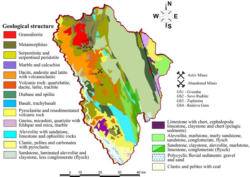
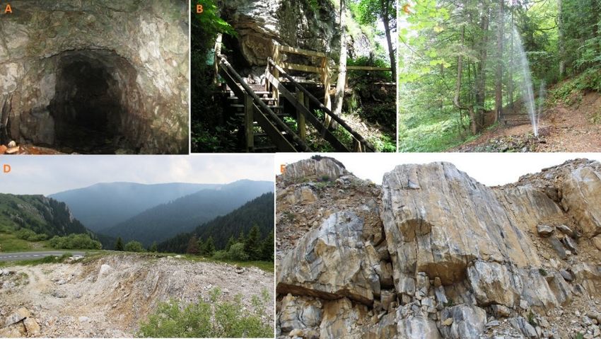
Minerals 2020, 10, 269 6 of 24

hydrogeological barrier, represented here by the granodiorite platon. The water springs are clear and
do not get dirty even with heavy rainfall and snowmelt, and are also chemically completely correct
for drinking. During the exploration of the ore body, from the exploration well, at a pressure of 1.5–
2 l/s, a hydrological phenomenon occurs within the magmatic granodiorite breakthrough called the
geyser Gvozdac [61]. North of this locality, at Jelica, i.e., from Jaram (1.788 m) to Srebrnac, all varieties
of skarns can be traced from their contact with granodiorite to weakly metamorphosed limestones.
This cites characterizes rarity, accessibility and practical educative value, making it a geoheritage
object worth of protecting. In the inventory list of geoheritage objects in Serbia, it is included in the
group called “Igneous and metamorphic rocks” as “Outcrops of skarns‐Jaram, Kopaonik”. Steep
limestone escarpments (bele stene) on the left side of the road Brzeće‐Kopaonik, in a part known as
Zavoj (curvature), were named Žljeb due to their well‐expressed curves (1.772 m) (Figure 4). Bele
stene (white rocks) were formed along a fault that separate two distinct lithologies: metamorphic
rocks below and carbonate rocks above. Transition from one to another lithology is obvious [60].

 Figure 3. Geological structure Kopaonik area [66].
Minerals 2020, 10, 269 7 of 24

 Figure 4. (A) Mining shaft; (B) cave church “Metođe”; (C) geyser “Gvozdac”; (D) mountain pass
 “Zavoj”; (E) skarns in Jaram.

 Suvo Rudište (GS2) is an ore field beneath Pančic Peak, at an altitude between 1878 and 1970 m,
known as the largest skarn and iron ore deposit. It extends from the northwest to the west, as the
surface excavation of the amphitheater form resulted from intensive exploitation. The mine is in a
series of sericite chlorite shales and phyllites from the Paleocene period. It is characterized by low
crystallinity and consists of quartz, sericite, chlorite, biotite, zircon, apatite and tourmaline. In the
immediate vicinity are the Paleozoic crystalline limestones, dolomites, marbles and calcic formations
that make up the central Kopaonik series (Figure 3) [66]. The contour is identified with the contact‐
metamorphic halo of Triassic sediments at the core of which is the granodioritic intrusion of
Kopaonik. Today, a depression of an ellipsoidal shape with a diameter of 350–200 m remains on the
ledge, which makes about 7 ha of horizontal projection with lateral extensions of about 2–2.5 ha on
the accompanying active surface [61]. The exploitation of the ore was also carried out by a cave route.
Thus, below the surface there is a large number of cave rooms from which underground mine waters
nowadays come from. The mine field is located directly next to the high pyramid, which is at the top
of the second elevation point in Kopaonik (1976 m) and the site of Suvo Rudište, which belongs to
the first degree of protection. This site includes Pančic Peak (2017 m) and the northeast slopes of Suvo
Rudište. These areas have beautiful views. The area is 2 km away from the tourist settlement,
connected by cable cars and is 3 km by car. The moderately steep slopes of these peaks were used as
the slopes (Figure 5).

 Figure 5. (A,B) Surface excavation at an ore field “Suvo Rudište”; (C) tailings at an ore field; (D) Pančić
 Peak; (E) view from the ore field to the tourist center “Kopaonik”; (F) pyramid (1976 m).
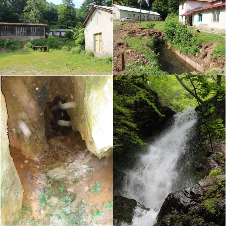
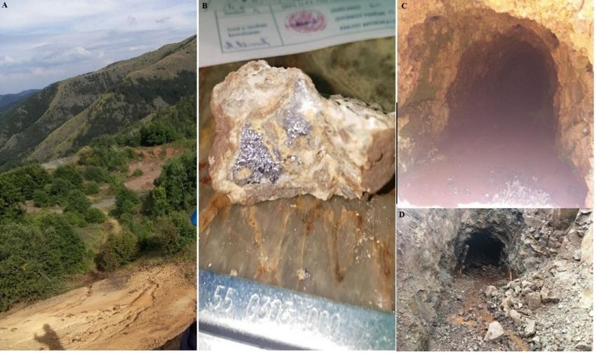
Minerals 2020, 10, 269 8 of 24

 Belo Brdo–Zaplanina (GS3) is a complex of underground mines of lead and zinc ore. It is located
in the III degree of protection regime, 5 km southeast of Pančić Peak. The wider surroundings of the
Belo Brdo deposits are built by geological formations of different ages, genesis and composition.
Among them are the oldest rocks, the so‐called Paleozoic metamorphites, which form the central part
of Kopaonik, and are located in the immediate halo of the Kopaonik intrusive. In their geological
structure, fracture structures as forms of deformation elements are highly expressed and present. In
relation to general rendering, they are classified into longitudinal (NW–SE), transverse (NE–SW) and
diagonal (E–W). The most significant, for the structure of the reservoir environment, is certainly the
regional fault structure of the northwestern orientation on the stretch from “Vojetina” to “Šatorica”,
which indicates the tectonic contact of serpentinite towards the rocks of the Triassic, Jurassic and
Cretaceous ages (Figure 3) [61]. Ore exploitation began in 1933. For the purposes of mining activities
in 1936, a tunnel 2.5 km long was dug, which served as the main road for the export of ore from all
horizons in the Belo Brdo and Zaplanina mine complex, which, at that time, represented the
technological and production unit. Remains of old mining pits are visible in the mining area of Mount
Vojetina.
 Zaplanina is higher and, in its highest part, the entrance to the shaft was at an altitude of 1425
m, today this shaft is almost invisible because it collapsed; the major mine shafts lie at an altitude of
1235 m. They are entered via a mining elevator from Belo Brdo, the lower part of the mine [65]. There
is a northeast entrance to the mine in Zaplanina which is no longer active today. Today, there is a
small number of local people in this mine who are assigned to maintenance work. Immediately next
to the Zaplanina is the Jelovarnik site, which belongs to the first degree of nature protection regime.
It encompasses both valley sides of the watercourse that flows below Pančić Peak (2017 m) and
Nebeske stolice Peak (1913 m). The main feature of the site is the cascading waterfall which is 71 m
high. The waterfall is a hydrological monument of nature under strict protection (Figure 6).

 Figure 6. (A,B) Mining facilities in Zaplanina; (C) a mine shaft in Zaplanina; (D) waterfall
 “Jelovarnik”.

 The Raičeva Gora Mine (GS4)—the deposit of lead‐zinc ore and antimony is found in quartzlatites
of neogene age. The wider area is made up of Harzburgites of Triassic age (Figure 3) [66]. The site is
located on the mountain slope of the Belo Brdo–Zaplanina mine, at an altitude of 1300–1400 m (Figure
7). It was opened in 1963, only to be closed after four years due to the fall in the price of this metal in
the world market. In the year 1977 production at the mine was restored and at the beginning of the
Minerals 2020, 10, 269 9 of 24

1980s, new surface and deep mining–geological surveys were carried out. Along with the innovations
in mechanization and mining equipment, access roads were made to the site. The mine built a 12 km
long transmission line from the Belo Brdo mine. A telephone line, water supply and other
infrastructure elements were added. With two horizons, 1220 and 1175 m above sea level, the ore was
being descended to the point of flotation. During the period from 1978 to 1984, the mine suffered a
crisis which was further contributed to by the devastating earthquake of 1980 with the epicenter not
far from the mine. At the end of 1991 it ceased to operate [65]. With its activity, the mine revived
mountain settlements in this area and slowed down migration processes on the village–city route,
but with the closure of the mine, the settlements disappeared. Upon the closure of the mine, larger
quantities of basalt ore were found in its wider surroundings, but despite detailed exploration, the
exploitation was not realized. The mine is located 8 km away from the regional road Kuršumlija,
Kopaonik, from the settlement Blaževo.

 Figure 7. (A) Raičeva gora; (B) antimony ore sample from the site; (C,D) mine shafts.

2.3. Methods
 The survey included three abandoned mines (Gvozdac, Suvo Rudište and Raičeva Gora) and
one which is active (Belo Brdo–Zaplanina). These mines have not been the subject of significant
exploration, and consequently there has been no tourist valorization. The geosite evaluation (GAM
method) will give ratings for several thematic value groups that are classified into two basic value
groups (main and additional), while evaluating critical issues: Soil Contamination, Water
Contamination, Acid Mine Drainage, Visual Impact and Hydrogeomorphological Impact; and
Positive Values: Geological Value, Landscape and Ecological Value, Historical Mining Value,
Archeological Value and Touristic Value, and get total grades that will be determined by partial
values. By comparative analysis of the obtained results, by different methods, we will get information
on which of the analyzed fields require more attention and better management in the future in order
for these sites in the of Kopaonik area to attract tourists.
 Two completely independent methods were applied in the study. The first (GAM) method,
scientifically based and verified in highly ranked scientific journals, has been applied to determine
the geotourism values of mines, a method which is supported by the research objective. This method
pointed out to us advantages and disadvantages of individual indicators. Since the research has a
twofold aim, to carry out an assessment of ecological values in addition to geotourism values,
(ecological status), another method, also scientifically based and verified, was applied, consisting of
two groups of questions: critical and positive. Although independent of the first method, in one part
there appears to be a match of positive values/questions with one small part of the questions and
indicators in the GAM method. We have neglected this, and all authors agree that it is necessary to
apply both methods independently in the given form, in order to achieve the set goal of the research.
Minerals 2020, 10, 269 10 of 24

Among other things, it is only through the full application (in terms of critical issues and positive
values) of the method for the assessment of ecological values (ecological status) that it is
methodologically possible to establish a final assessment. On the other hand, the GAM method is
more complex and contains more indicators and subindicators, therefore it is more relevant for the
achievement of the first research objective (determination of geo‐tourist values).
 The research consists of two phases. During the first phase, the bibliographies are collected:
scientific and professional papers, old records, books, guides, lexicons; technical records: mining
plans, old maps, legal records; old paintings, photographs, drawings, processing of collected data
and GIS visualization of the mine. The second phase concerns field research and interviewing of the
local population, conducted between May and August 2019.
 In the second phase of the research, two scientifically based methods were applied. The first is
the Geosite Assessment Model (GAM) scientifically based for geolocation evaluation purposes. The
model was created by Vujičić et al. [54] based on a numerous scientific works in the field of evaluation
[46,67–75] and it was scientifically established later on [49,60,76]. This method evaluated the
subindicators, on the basis of which the assessment of the geo‐tourist values of the mine was
determined.
 The GAM consists of two groups of values: main values (MV) and additional values (AV) (Table
1).
Minerals 2020, 10, 269 11 of 24

 Table 1. The structure of Geosite Assessment Model (GAM).

 Main Values (MV)
 Scientific Educational/Value (VSE) 0.00 0.25 0.50 0.75 1.00
 Rarity (number of the same localities in the
1 A common occurrence Regional Nacional International Unique
 immediate area).
 Representativeness (didactic and school
2 characteristics of localities based on their quality None Low Medium High The highest
 and configuration).
 Level of site research (number of publications in Regional National International
3 None Local publications
 scientific journals). publications publications publications
 Level of interpretation (possibility of interpretation
 Intermediate level– Good example– Medium level– Good example and
4 of geological and geomorphological processes, None
 difficult to explain difficult to explain Easy to explain easy to explain
 phenomena and forms).
 Scenic/aesthetic value (VSA)
 Lookout points (number of lookouts within 1 km of
5 None 1 2 to 3 4 to 6 More than 6
 the site).
6 Area (total area of the site relative to other sites). Small ‐ Medium ‐ Big
 Landscapes and nature in the surroundings
7 ‐ Low value Medium High The highest
 (panoramic view quality).
 Fitting the locality into the environment (degree of
8 It does not fit ‐ Neutral ‐ Fits in
 contrast with nature).
 Protection (VPr)
 Moderately Moderately
9 Current state of geosite. Completely destroyed Very damaged Undamaged
 damaged damaged
 Level of site protection (by local and regional Protected Protected Protected
10 Unprotected Protected locally
 associations, national or international institutions). regionally nationally internationally
 It cannot be
11 Geosite sensitivity level. Beyond repair High Medium Low
 seriously damaged
12 The corresponding number of visitors to the site. 0 0 to 10 10 to 20 20 to 50 More than 50
 Additional values (AV)
 Functional values (VFn)
 Medium (by
1 Possibility of access to the site. Inaccessible Low (only by foot) High (by car) The highest (by bus)
 bicycle)
2 Additional natural values within 5 km. None 1 2 to 3 4 to 6 More than 6
3 Additional anthropogenic values within 5 km. None 1 2 to 3 4 to 6 More than 6
Minerals 2020, 10, 269 12 of 24

4 Proximity to emission centers. More than 100 km 100 to 50 km 50 to 25 km 25 to 5 km Less than 5 km
5 Proximity to important roads within 20 km. None in the vicinity Local road Regional road National road International road
 Additional functional values (parking lots, gas
6 None Low Medium High The highest
 stations)
 Tourist values (VTr)
7 Level of promotional activities. None Local Regional National International
 From 12 to 24 a From 24 to 48 a
8 Number of visits to the geosite. None Less than 12 a year More than 48 a year
 year year
 9 Proximity of visitor centers to the geosite. More than 50 km From 50 to 20 km From 20 to 5 km From 5 to 1 km Less than 1 km
10 Interpretive panels that fit the environment. None Low quality Medium quality High quality The highest quality
 Medium (from High (from 10,001 The highest (more
11 Annual number of visitors to the geosite. None Low (less than 5000)
 5001–10,000) to 100,000) than 100,000)
 Tourist infrastructure (hiking trails, rest places,
12 None Low level Medium level High level The highest level
 toilets).
13 Level of guidance service expertise. None Low quality Medium quality High quality The highest quality
14 Accommodation services near geolocation. More than 50 km 25–50 km 10–25 km 5–10 km Less than 5 km
15 Restaurant services near geosite. More than 25 km 10–25 km 10–5 km 1–5 km Less than 1 km
Minerals 2020, 10, 269 13 of 24

 Main values (MVs) arise from the natural characteristics of the geosites and are made up of three
groups of indicators: scientific/educational value (VSE), landscape/aesthetic value (VSA) and
protection (VPr). Additional values (AV) are created by human influence and adaptation for them to
be used by visitors. They are made up of two groups of indicators: functional (VFn) and tourist value
(VTr) [54]. A total of 12 MV subindicators and 15 AV subindicators are estimated to be 0.00, 0.25, 0.50,
0.75 and 1.00, which defines GAM as the following equation [76]:

 . (1)
 The following two equations are derived from the groups of subindicators:
 , (2)
 , (3)

i.e.,

 , ℎ 0 1, (4)

 , ℎ 0 1, (5)

 For the purpose of graphical representation of the evaluation results, a GAM matrix has been
created, which is divided into nine fields (zones) using a grid, denoted Z (i, j) (i, j=1,2,3). The matrix
consists of the X (MV) and Y (AV) axes, which represent the geosite values. The main lines of the
network have values of four units on the X and five units on the Y axis. Depending on the grade, the
estimated geosite occupies a certain field, which clearly determines its value and, depending on the
main values, the existence of so‐called “tourist value”.
 The second method relates to the evaluation of the parameter from which the total value of
environmental issues is derived. The estimation model used was performed according to the
methodology used by Marescotti et al. [77] on the example of the sulfur mines of the Gromolo and
Petronio valleys of Eastern Liguria in Italy. The reason for choosing this methodology stems from the
subject matter of this study, and the research concerns evaluation of critical issues (CI) and positive
values (PV). Given groups of values are made up of five values for the assessment, from zero to four.
The assessment of the ecological status of the sites, together with the assessment of geo‐tourism
values, was carried out by a group of six experts from the relevant fields based on their observations.
The estimated values are given using the following numerical values: 0 (Zero), 1 (Low), 2 (Medium),
3 (High) and 4 (Very high).
 A group of experts obtained preliminary information from the field research on the mine’s
ecological status, potential problems and risks based on easily visible changes in the field in the form
of visual degradation of the mine (landslides, collapses, excavations, landfills and disposal of mine
waste and other damaged soils, pollution and water turbidity). This is a form of strategic
environmental impact assessment that indicates the need to encourage future specialized
experimental research. For this research, based on the criteria according to the methodology applied
[77], was assigned a numerical value for each question, qualitative and quantitative research. The
sum of these partial values determined the overall score.
 Evaluation of the critical issues (CI) consists of the following elements: Soil Contamination (Sc),
Water Contamination (Wc), Acid Mine Drainage (Ad), Visual Impact (Vi) i Hydrogeomorphological
Impact (Hi) (Table 2).
Minerals 2020, 10, 269 14 of 24

 Table 2. Evaluation scores for critical issues (CI).

 Value Score CI‐1. Land Pollution
 Very Pollution is spreading throughout the mining area, including tailings pits, waste stone
 −4
 High dumps, open pits, factories, etc.
 Pollution mainly concerns mining structures and infrastructures throughout the mining
 High −3
 area.
 Pollution is present at given sites and is reduced to mining structures (open pits, tunnel
 Medium −2
 entrance, small deposits of waste stone, etc.).
 Low −1 Pollution occurs locally in several places throughout the mining area.
 Zero 0 No land pollution
 Value Score CI‐2. Water pollution
 Very Water pollution is present in the wider mining area, including mining water and
 −4
 High natural waters.
 Water pollution mainly refers to the mining water circulating in or collecting within the
 High −3
 mining area.
 Medium −2 Water pollution is present in several localities.
 Low −1 Water pollution is minimized.
 Zero 0 No pollution.
 Value Score CI‐3. Mining acid running off
 Very Mineral acid swelling is possible and persistent. Acidic water spreads through the
 −4
 High mining area, thus polluting natural waters.
 Mineral acid swelling is possible and persistent. Acidic waters are reduced to or
 High −3
 collected by mining waters that circulate through the mining area.
 Mineral acid swelling is possible and persistent. Acidic water is present in some specific
 Medium −2
 places.
 Mineral acid swelling is possible and persistent. Acid waters have been reduced to only
 Low −1
 a few specific places.
 Zero 0 Swelling of mining acid is almost impossible.
 Value Score CI‐4 Visual influence
 Very The spread of decomposed elements and degraded spaces is present throughout the
 −4
 High whole area and in the environment.
 High −3 The spread of decomposed elements has been reduced to mining space.
 Medium −2 The decomposed elements are visible only in certain places within the mining area.
 Low −1 Several decomposed elements are visible at a couple of sites within the mining area.
 Zero 0 No decomposed elements in the mining area and in the environment.
 Value Score CI‐5 Hydrogeomorphological influence
 Important due to the presence of underwater and surface excavations, waste stone
 Very
 −4 landfill and tailings dams throughout the mining area. Landslides, evidence of
 High
 accelerated erosion, subsidence, sinking and other key features are spreading.
 High −3 Most of the key issues are reduced to specific places within the mining area.
 Exclusive presence of underground excavation. Waste stone landfills have been
 Medium −2
 reduced to one or two sites. Other key issues are present but not spreading.
 Exclusive presence of underground excavation. Waste stone landfills are limited in size
 Low −1
 and other key problems are rare.
 The exclusive presence of underground excavation and the absence of landfill dumps.
 Zero 0
 Other key problems are not present.

 Soil Contamination (Sc): soil contamination depends on the presence of toxic elements in the
exploited ore. In each of the four sites analyzed, the intensity of contamination is directly related to
the extent of mining activity in the area, from the volume of underground and surface excavations,
rock depots and disposal of waste materials, processing plants for ore extraction, surfaces for
temporary storage, etc.
 Water Contamination (Wc): water contamination depends on the reactivity of the minerals of the
exploited ore. The intensity of water pollution is directly related to the extent of mining activity in
the area and to the geometry of the basin relative to the area of the mine.
Minerals 2020, 10, 269 15 of 24

 Acid Mine Drainage (Ad): acid mine drainage depends on the presence and relative volume of
sulfides (mainly pyrites and pyroids) in the ore and/or rocks exploited. Pyrite and pyrrhotite are
mainly non‐economic minerals in polymetallic sulfide ores and are therefore usually discarded and
deposited in rock deposits. The capacity of rocks and sediments to generate AMD can be calculated
according to the Australian Mineral Industries Research Association (AMIRA) procedure [78]. If
AMD is possible and continues over time, its intensity is directly related to the extent of mining
activity in the area and to the basin geometry relative to the acid production sites.
 Visual Impact (Vi): the visual impact on mine sites has been evaluated based on the presence and
visibility of degraded elements that induce contrast in shapes, textures and colors. These are
particularly represented by mining activity remains with very low aesthetic quality or in an evident
state of decay and changes in landscape and morphology. The class and relative score were assigned
considering both the extent of the visual impact inside the site and the extent of the impact on the
surrounding landscape evaluated outside the mining area. Other anthropic elements were also
considered, even if not directly related to mining activities.
 Hydrogeomorphological Impact (Hi): the hydrogeomorphological impact within a mining area is
mainly due to the strong surface modification of the former topography and the realization of
underground excavations. These modifications can affect surface and groundwater circulation and
create potential ground deformations, subsidence, and steep slope problems, thus inducing several
geological hazards, such as floods and landslides. The class and the relative score, evaluated by
geomorphological photointerpretation, the evaluation of mining plans and field investigations were
assigned considering the extent of modification induced by mining activities and by verifying the
presence of critical issues within the mining sites and in the surrounding areas.
 . (6)
 Evaluation scores for positive values (PV) consists of the following elements: Geological Value
(Gv), Landscape and Ecological value (Lv), Historic Mining Value (Hv), Archeological Value (Av) i
Touristic Value (Tv) (Table 3).
 . (7)
 The total score (TS) consists of the summary assessment of partial scores of CI and PV according
to the formula:
 . (8)

 Table 3. Evaluation scores for positive values (PV).

 Value Score PV‐1. Geological Value
 Very
 4 Within the mine and in the surrounding area, there are valuable geological elements.
 High
 High 3 Valuable geological elements are found within the mining area.
 Medium 2 Geologically valuable elements are found in several localities within the mining area.
 Geologically valuable elements are found in one or more localities within the mining
 Low 1
 area.
 Zero 0 There are no valuable geological elements in the mining area.
 Value Score PV‐2. Landscape and Ecological Value
 Very There are ecological values in the mine and its environment with high landscape values
 4
 High and evocative elements.
 In the area of the mine there are ecological values and landscapes of high quality and
 High 3
 evocative elements.
 Some environmentally friendly elements are present in the surrounding areas. A
 Medium 2
 landscape with some scenic quality and evocative elements
 There are few environmentally friendly elements in the surrounding areas. The
 Low 1
 landscape is of poor scenic quality and with little evocative elements
 There are no recognized environmental elements in this area. Landscape does not have
 Zero 0
 a scenic quality or evocative elements
Minerals 2020, 10, 269 16 of 24

 Value Score PV‐3. Historic Mining Value
 Very For the mine and the surrounding area, there are numerous valuable elements
 4
 High concerning mining history.
 Valuable elements pertaining to the history of excavation within the mine site are
 High 3
 present.
 Medium 2 There are some valuable elements related to mining history within a mine site.
 Low 1 There are few valuable elements related to mining history within the mine site.
 Zero 0 Absence of valuable elements related to mining history.
 Value Score PV‐4. Archeological Value
 Very The presence of archeologically valuable elements in the mine and the surrounding
 4
 High area is widespread.
 High 3 There are several archaeologically valuable elements in the mining area.
 Medium 2 Archaeologically valuable elements are found at one or more sites in the mining area.
 Low 1 Archaeologically valuable elements are present but not available.
 Zero 0 Absence of archaeologically valuable elements.
 Value Score PV‐5. Tourist Value
 Very There are numerous tourist attractions and services in the area of the mine and in its
 4
 High wider environment.
 High 3 Tourist attractions and services are present in the area and are linked to mining sites.
 Some tourist attractions and services are present in the surrounding area, while mining
 Medium 2
 sites are generally available.
 Several tourist attractions are present in the area, and mining sites are accessible with
 Low 1
 some difficulty.
 Zero 0 There are no tourist attractions in the immediate vicinity of the mine.

3. Results
 The final results of the analyzed geosites are presented in Table 4, and are presented graphically
in Figure 8. The main values (scientific/educational, landscape/aesthetic and protection) record slight
oscillations and range from medium to high levels of values. GS2 has the highest scientific value (2.75).
The reason is that the geosite is located at an altitude of over 1500 m and, as such, is unique in the
wider area. It can serve as a good example of the interpretation of geological and geomorphological
processes, phenomena and forms to the average visitor. Numerous Kopaonik researchers have
written about this geosite. The GS3geosite has an intermediate level of scientific value, while GS1 and
GS4geosites have low scientific value. With their large number of viewpoints, vast areas, high
panoramic views with hydrological phenomena and preserved vegetation, the analyzed geosites give
high landscape/aesthetic values. As the geosites GS1, GS2 and GS3 are located in the area of Kopaonik
National Park, research has confirmed that they belong to a high level of protection, while GS4
belongs to a medium level of protection.
 Compared to the smaller differences in the main values among the analyzed geosites, the
differences are more significant in the additional values (functional and tourist values). GS2geosite
has the highest functional value (4.00), it is characterized by the possibility of access to all visitors,
the existence of natural and anthropogenic tourist values, the proximity of the mountain tourist
center Kopaonik, as well as the highest level of other functional values. The GS1geosite (3.25) has a
significantly lower functional value. The geosite is not available to all visitors. Mountain paths lead
to the site, where there are hydrological sites and protected plant species, as well as other natural and
anthropogenic tourist values. Not far from the site there is a main road with additional functional
values in Brzeće, Srebrenac and Kopaonik. The functional value of the GS3geosite (2.75) is lower than
the GS2 and GS1 geolocal values, which was influenced by the ability to access the geosite and a
slightly larger distance from other functional values. The GS4geosite has the lowest functional value
(2.00) among the analyzed geosites. It is characterized by a great distance from the broadcasting
centers, important roads and other additional functional values. Research has shown that the
differences between geosites are greatest in tourist values. The GS1 and GS2 geo‐localities have
Minerals 2020, 10, 269 17 of 24

developed tourist infrastructure and are attractive tourist sites, while the GS3 and GS4 localities do
not have tourism infrastructure, but their possibilities for existence are different. The GS3geosite is 10
km away from accommodation and restaurant services (Fast), and the GS4geosite is much longer.

 Table 4. Overall evaluation of the analyzed geosites using the Geosite Assessment Model (GAM).

 Main Values Additional Values Field
 Name of Geosite
 VSE + VSA + VPr ∑ VFn + VTr VSE + VSA + VPr ∑
 Gvozdac (GS1) 2.25 + 2.25 + 2.50 7 3.25 + 7.00 10.25 Z23
 Suvo Rudište (GS2) 2.75 + 3.25 + 2.75 8.75 4.00 + 8.50 12.50 Z33
 Belo Brdo‐Zaplanina (GS3) 2.50 + 3.75 + 2.50 8.75 2.75 + 2.00 4.75 Z31
 Raičeva Gora (GS4) 2.25 + 3.50 + 2.25 8.00 2.00 + 1.25 3.25 Z21/31
 Mean value ‐ 8.13 ‐ 7.69 ‐

 Comparing the final results for all fourgeosites, we can see that the differences in the principal
and additional values, as well as their positions in the GAM matrix, prevail (Figure 8). The GS2
locality has the highest value, it belongs to the Z33 field, which indicates a high level of major and
tourist values. Field Z23, shows the mean of the main and the high level of additional values, and the
geosite of GS1is found in this field. The GS3 and GS4 localities emphasize the differences between
main and additional values, localities have high main values, but low additional ones. Thus, the
locality GS3 was located in field Z31 and the locality GS4 was located at the border between fields Z21/31.
The low values at these sites concern additional functional and tourist values, and the result can be
the basis for the development of future tourism development strategies in the Kopaonik area,
especially for sites that have high scientific and landscape values, as well as the level of protection.

 Figure 8. Location of estimated geosites in the GAM matrix.

 One of the major drawbacks is the accessibility, promotion and organization of visits as well as
a quality guide service. More qualified guides are needed, preferably from the geological or related
profession, or from the field of geosciences. Not far behind these activities and amenities, there are
also elements such as interpretative boards and tourist infrastructure. GS1 and GS2 are geolocities that
are on the list of tourist visits to Kopaonik National Park and, as such, should be presented to local
and foreign tourists as much as possible, while deficiencies in the GS3 and GS4 geosites must be
eliminated in order to develop tourism and sustainable economic development of the settlements in
the area.
Minerals 2020, 10, 269 18 of 24

 The overall results of the evaluation of critical issues and positive values of abandoned Gvozdac,
 Suvo Rudište and Raičeva Gora mines and partially abandoned Belo Brdo–Zaplanina mine in the
 Zaplanina area are given in Table 5.
 Mining activities, such as mine exploitation, ore processing and waste disposal in landfills are
 worldwide sources of heavy elements in the surface environment [79]. In mining sites, soil is an
 environmental compartment commonly contaminated by heavy elements, mainly through wet and
 dry depositions of emissions from smelters and the runoff of waste accumulated in dumps. Since the
 closure of the mine to the present day, Suvo Rudište and Raičeva Gora have been completely
 abandoned and, thus, present a source of unresolved environmental problems and a danger to living
 beings.
 Suvo Rudište is the largest and most important mine in Kopaonik area, which has low values
 for soil and water pollution when it comes to critical issues, but leaving large surface and
 underground mines in the mine field without taking special protection measures poses a great threat
 to human and animal safety—especially since the mines are located directly along the ski slopes of
 this largest mountain tourist center in Serbia.
 Raičeva Gora has the highest number of reward points, plenty of mining waste and other
 abandoned infrastructure that affects soil contamination. The physical and chemical characteristics
 of this waste, together with mine water, affect the environment. Frequent rainfall in these
 mountainous areas, which is especially pronounced in the spring months, completely changes the
 chemical composition of the Toplica River, which runs along its entire length along arable land. The
 visual impact of the ore fields disrupts the overall visual appearance that nature has created in this
 area. The created tailings from accumulated mining waste in some locations can cause landslides and
 avalanches.
 Part of this exploration is the area of Zaplanina, which is part of the Belo Brdo mine, where the
 northeast entrance to the mine was located. Today, there are ancillary facilities in this area that house
 miners in charge of mine maintenance and there also remains a part of the mining infrastructure. The
 site has recorded several sites with soil and water pollution, which represents a low level of critical
 issues.
 The least critical issues are the Gvozdac mine, which has visible traces of exploration but no
 significant traces of exploitation. The mine is located at the largest spring in Kopaonik, known as the
 Gvozdačka Vrela. The rocks are of such composition that they do not affect water pollution, and the
 area is arranged on footpaths and accessible to visitors.

 Table 5. Total scores for the four mines studied.

 Gvozdac Suvo Rudište Belo Brdo‐Zaplanina Raičeva Gora
 Mining Site
 (GS1) (GS2) (GS3) (GS4)
 Soil Contamination (CI1‐Sc) 0 −1 −1 −3
 Water Contamination (CI2‐Wc) 0 −1 −2 −2
Critical Issues

 Acid Mine Drainage (CI3‐Ad) 0 −1 −2 −2
 Visual Impact (CI4‐Vi) −1 −2 −1 −2
 Hydrogeomorphological Impact
 0 −3 −2 −2
 (CI5‐Hi)
 Partial Score −1 −8 −8 −11
 Geological Value (PV1‐Gv) 3 4 2 2
Positive Values

 Landscape and Ecological value
 4 4 4 3
 (PV2‐Lv)
 Historic Mining Value (PV3‐Hv) 4 4 4 3
 Archeological Value (PV4‐Av) 2 3 3 3
 Touristic Value (PV5‐Tv) 3 4 2 1
 Partial Score 16 19 15 12
 Total Score 15 11 7 1
Minerals 2020, 10, 269 19 of 24

 Other than critical issues, the most positive points go to the “Suvo Rudište” ore field, which
extends at high altitudes, in an area that has large geological, archeological and tourist potentials.
There are beautiful views on all sides of the mine field, the area is easily accessible to all visitors—it
is located below Pančić Peak (2017 m) and within the Suvo Rudište Nature Reserve, which belongs
to the first degree of the nature protection regime.
 Belo Brdo–Zaplanina mine is a unique entity that cannot be taken into consideration for tourism
because the administrative line separating central Serbia with Kosovo and Metohija crosses the
highest parts of this mine and, thus, diminishes its tourist significance. This mine is of great historical
and archeological value; natural values allow the development of tourism, but this is limited only to
the part of the mine located in Zaplanina.
 The abandoned Gvozdac mine, with the Gavranovac Peak, the iron hot springs, geyser Gvozdac
and the Metođe shrine, is one of the must‐see excursions sites for visitors (tourists) who come to
Kopaonik. The Metođe and Jelak nature reserves make the area attractive for tourists. Arranged
footpaths, resting places, signposts and interpretative signboards make the area significant for
tourism and have the highest positive value in overall results.
 The least positive values in the overall results go to the abandoned Raičeva Gora mine. The large
number of negative points, the great distance from the main tourist center on Kopaonik as well as the
distance from the main road, without tourist infrastructure, makes the area unattractive.
 In the designated sites, negative environmental issues relate to soil pollution due to the
accumulation of mining waste (tailings) and water pollution due to the runoff of mining waters in
certain designated places. This ecological status in the areas of abandoned mines with certain plans
of rehabilitation and reclamation can offer the opportunity for tourism development.
 In the field survey, the local population in the immediate vicinity of the mines and tourists
located on Kopaonik (Brzeće, Pančićev vrh and Kopaonik tourist resort) were interviewed. On this
occasion, several conclusions were reached. The Gvozdac locality is well presented to tourists, with
clearly marked trails, resting places, interpretative boards, etc. The tourists recommend the area to
all other potential tourists due to the fact that it has different forms of geo‐heritage and should be
visited. Tourists visit this site during the winter tourist season, with the highest number of visits
being recorded in summer. The Suvo Rudište locality is impressive to tourists. The need for expert
guides is emphasized in order to provide tourists with knowledge about the development of mining
at Kopaonik, and a higher level of protection in the area of the abandoned mine. Tourists are present
at this site throughout the year, but the tourist values of this site are visible in periods without snow.
The Zaplanina locality is not on the Kopaonik tourist map, but tourists are aware of its archeological
and historical importance. Tourists would visit the site to get a more complete picture of the time and
manner of active mining in Kopaonik. Tourists are actively visiting tourist sites in the immediate
vicinity of the mine, while the evaluation of tourist potentials at the site has especially been welcomed
by the locals, who emphasize their willingness to participate in the tourism development process.
The location of the abandoned Raičeva Gora mine is completely unknown to Kopaonik tourists. The
locals share the view that the revitalization of this once very important economic object for tourism
purposes would bring life back to the settlements. The idea of a group of researchers has been warmly
received by the locals and they emphasize their willingness to actively participate in the tourism
development process.

4. Conclusions
 After many years of research in the area of Kopaonik and getting to know all the tourist values
in this area, the need to assess all the negative impacts and positive values associated with the
presence of abandoned and partially active mines arose, in order for them to be restored and included
on the tourist map of Kopaonik. In this study, two parallel assessments were made: an assessment of
tourism values and an assessment of environmental issues. These are preliminary assessments that
provide a very important driving force for local development and define further directions for
research.
Minerals 2020, 10, 269 20 of 24

 The reconstruction of abandoned mines and putting them into the function of tourism requires
a large amount of information to be collected, assessing the possibilities for their reconstruction,
making a plan for their reconstruction and implementation. Based on the results of the research, it is
necessary to carry out a procedure and make a plan for the elimination of all negative impacts on the
sites, as well as a plan for exploiting all the positive values that may affect the development of tourism
at the sites and in their surroundings. The results of the research showed that the assessment of
tourism potential coincides with the results of the assessment of positive values for environmental
issues at the sites, thus confirming the fact that the analyzed geosites can be put in the function of
tourism development, which imposes the need to eliminate all negative criteria. The Kopaonik area
is very attractive in terms of geology, geomorphology, hydrogeology, climate and biogeography, and
the tourist valorisation of abandoned mines in this area can contribute to the greater attractiveness of
the area itself. These geo‐localities do not have the ability to independently attract the attention of
tourists, but in the tourist offer they can be found in complementarity with the tourist sites in their
surroundings. This is a polyvalent tourist area where several types of tourism can be developed.
According to its attractive features, Kopaonik has pronounced recreational features, while, in the
tourist market, Kopaonik is recognized as a mountain tourist center with a pronounced sports
manifestation function at national and continental levels.
 One of the main problems for tourists in the mining area is the issue of protection, especially in
the areas of surface and underground mines. As none of the analyzed mines initiated the technical
and technological process of rehabilitation and reclamation, some of the analyzed sites are
inaccessible to tourists (Zaplanina and Raičeva Gora). As the funds for these purposes are obtained
from the budget of the Republic of Serbia, such projects of local self‐government (Bruce and Raska)
will not be financially burdensome. The results of the study indicate the need to protect those local
self‐governments.
 The results play a special role in tourism development strategies in the observed area. In order
to develop tourism, the strategies maximize positive values and minimize negative ones, seizing all
opportunities and preventing all threats.
 The local population has an indispensable role in the development of tourism in this area. Any
positive change is intended to change the visual appearance of the settlement and the overall
economic development of the area.
 According to the tourist attractions and conditions for the development of tourism, abandoned
mines on Kopaonik have modest properties and, as such, they can develop in terms of tourism in
complementarity with other tourist values in the area.
 The methodology applied in this research could be improved in two segments in the future. First
of all, the methodology for evaluating geolocality on mine examples should be reduced in the section
for the assessment of geological and geomorphological parameters as well as protection parameters.
Secondly, besides the expert evaluation, tourists should be included in the evaluation of tourist
values. The reduction of the existing method and the inclusion of tourists in this part of the research
would not prove relevant, as some localities are still inaccessible for tourist visits.

Author Contributions: D.V., and D.R. (Dragan Radovanović) conceived of the presented idea; M.I., and D.R.
(Dušan Ristić) analyzed and elaborated the data for the GIS‐based database; D.V., R.I., D.R. (Dragan
Radovanović), J.D., and N.M.B. contributed to the historical research and field survey; M.I., and D.R. (Dušan
Ristić) made the figures. All authors discussed the results and contributed to the final manuscript. All authors
have read and agreed to the published version of the manuscript.

Funding: This research received no external funding.

Conflicts of Interest: The authors declare no conflict of interest.

References
1. Li, J.; Yang, L.; Pu, R.; Liu, Y. A review on anthropogenic geomorphology. J. Geogr. Sci. 2017, 27, 109–128,
 doi:10.1007/s11442‐017‐1367‐7.
2. Crutzen, P.; Stoermer, E. The “anthropocene”. IGBPNewsl. 2000, 41, 17–18, doi:10.1007/3‐540‐26590‐2_3.
You can also read