Auckland Downtown Ferry Basin Redevelopment Stage 1 Maritime Operations and Navigational Safety - Prepared for Auckland Transport by Navigatus ...
←
→
Page content transcription
If your browser does not render page correctly, please read the page content below
Auckland Downtown Ferry
Basin Redevelopment Stage 1

         Maritime Operations
      and Navigational Safety

                 Prepared for Auckland Transport
                                              by
                            Navigatus Consulting

                               07 November 2018

             1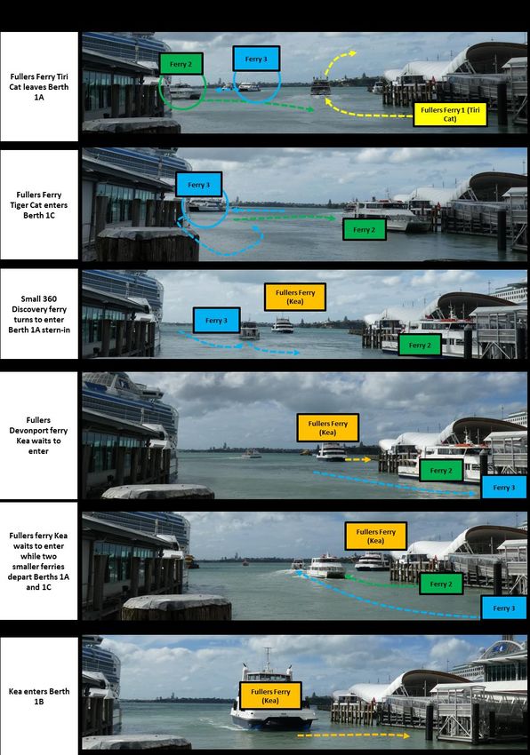
Prepared by Navigatus Consulting Ltd for:

Auckland Transport

Navigatus Consulting Limited
Level 2, 347 Parnell Road
PO Box 137249
Parnell, Auckland 1052
+64 9 377 4132
www.navigatusconsulting.com

Quality Control

Prepared by: Kevin Oldham, Celia Cunningham, Jess Spinetto
Reviewed by: Geraint Bermingham

                                                            Authorised By
           Revision             Date
                                                     Name                   Signature

Draft for client review   14 September 2018   K Oldham

Rev0                      01 October 2018     K Oldham

Rev0.1                    7 November 2018     K. Oldham

                                              2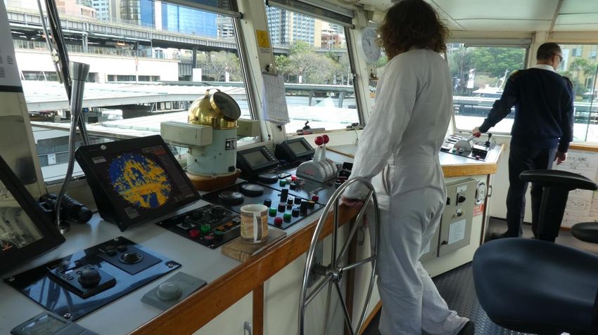
Table of Contents

1. Executive summary .................................................................................. 5

2. Introduction ................................................................................................ 6
     2.1. Development context ............................................................................................ 7
     2.2. Operational Criteria ............................................................................................... 8

3. Existing environment ................................................................................. 9
     3.1.    Activities in Basin .................................................................................................. 9
     3.2.    Demand for ferry services ..................................................................................... 9
     3.3.    Environmental conditions .................................................................................... 10
     3.4.    Visibility ............................................................................................................... 12
     3.5.    Regulatory .......................................................................................................... 12

4. Maritime traffic ........................................................................................ 14
     4.1.    Ferries and Ferry Services .................................................................................. 14
     4.2.    Ferry traffic volume ............................................................................................. 15
     4.3.    Basin flow and traffic observations ...................................................................... 15
     4.4.    Cruise Ships........................................................................................................ 18
     4.5.    Bunkering of Cruise Ships ................................................................................... 19
     4.6.    Waitematā Harbour ............................................................................................. 20
     4.7.    Freemans Bay..................................................................................................... 21
     4.8.    Viaduct Harbour .................................................................................................. 21
     4.9.    Interactions with Port and Harbour Activities ....................................................... 22

5. Navigational effects assessment: operational phase ........................ 23
     5.1.    Method of Assessment ........................................................................................ 23
     5.2.    Simulation 3 ........................................................................................................ 24
     5.3.    Assisting situational awareness........................................................................... 27
     5.4.    Pattern of Circulation........................................................................................... 28
     5.5.    Comparison to Circular Quay .............................................................................. 28
     5.6.    General public and passenger safety .................................................................. 30
     5.7.    Current Ferry Operations at Piers 3 and 4 ........................................................... 30
     5.8.    Operational conclusions and recommendations .................................................. 31
     5.9.    Maritime operations and safety assessment of proposal ..................................... 31

6. Navigational effects assessment: Construction phase ....................... 34
     6.1. Description of construction .................................................................................. 34
     6.2. Proposed navigational safety controls during construction .................................. 34
     6.3. Assessment ........................................................................................................ 38

7. Conclusions ............................................................................................. 39
     7.1. Operations .......................................................................................................... 39

                                                                   3
7.2. Construction ........................................................................................................ 39

References ..................................................................................................... 40

Appendix A. Ferry Basin Time Sequences ............................................... 41

Appendix B. Layout assessment ............................................................... 44
     Appendix B.1. Simulation Process ............................................................................. 44
     Appendix B.2. Ferry vessel ........................................................................................ 45
     Appendix B.3. Queueing Model ................................................................................. 46

Appendix C. Comparison to Circular Quay ............................................ 47
     Appendix C.1.          Method ............................................................................................... 47
     Appendix C.2.          Ferry Traffic ........................................................................................ 47
     Appendix C.3.          Layout ................................................................................................ 50
     Appendix C.4.          Movement of ferries ............................................................................ 50
     Appendix C.5.          Comparison to Downtown Ferry Terminal ........................................... 50
     Appendix C.6.          Learnings ........................................................................................... 51

Appendix D. Outline of Marine Safety Management Plan (MSMP)....... 52

Annex 1: Outcomes of Vessel Manoeuvring Simulation 3 (28 August) .. 54

                                                                 4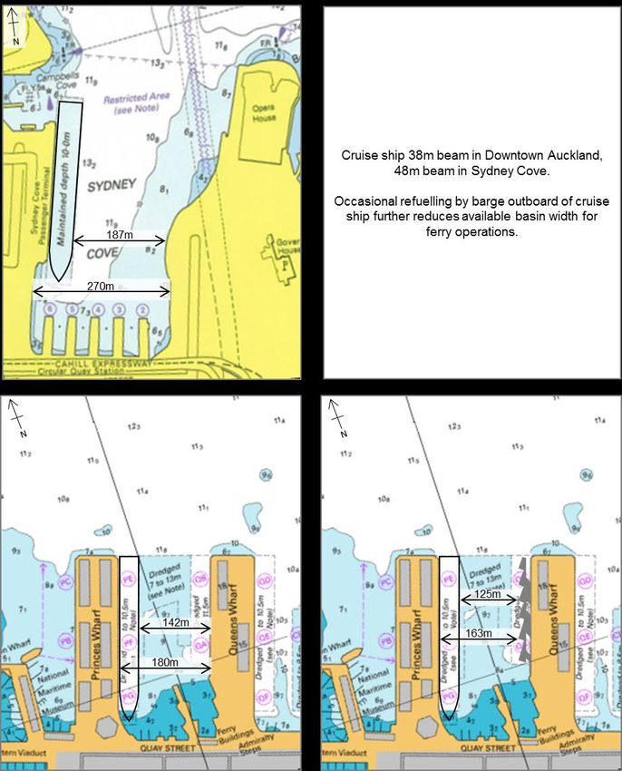
1. Executive summary
This report has been prepared by Navigatus for Auckland Transport to assess effects on
maritime operations, including navigational safety, arising from options for the
redevelopment of the Downtown Ferry Basin. The Downtown Ferry Basin is a busy transport
hub that at times under existing vessel traffic loads becomes congested.
The assessment process has included:
Direct observations of operations in the existing ferry basin
Time-lapse video footage of existing ferry basin operations
Bridge trips on ferries in Auckland and Sydney to observe operations from the ferry
master’s point of view
Discussions with ferry masters and operators
Discussions with the Auckland harbourmaster
Discussion with refuelling barge operators and Ports of Auckland
Comparison to existing ferry basin operations and to Circular Quay in Sydney
Simulations and queuing model
Our overall conclusion is that the reverse sawtooth layout on Queens Wharf West is a
practical proposal to replace Piers 3 and 4 from a maritime operations and navigational
safety perspective. We conclude that, with suitable operational controls, safe maritime
operations can be maintained under a wide range of environmental conditions and
operational demands with the proposed layout. Selection of the particular controls is an
operational decision to be made at the time by Auckland Transport in consultation with ferry
operators. The controls selected and their implementation will need to be to the satisfaction
of the Harbourmaster, acting under authority of the Maritime Transport Act.
General safety controls have been outlined for the construction phase of the project. It is
recommended that a suitable service is implemented to provide situational awareness
assistance to ferry masters to the satisfaction of the Harbourmaster (a Basin Construction
Control service). Provided that maritime safety and continuity of ferry operations are
prioritised, appropriate levels of maritime safety can be provided during construction with
careful management.
5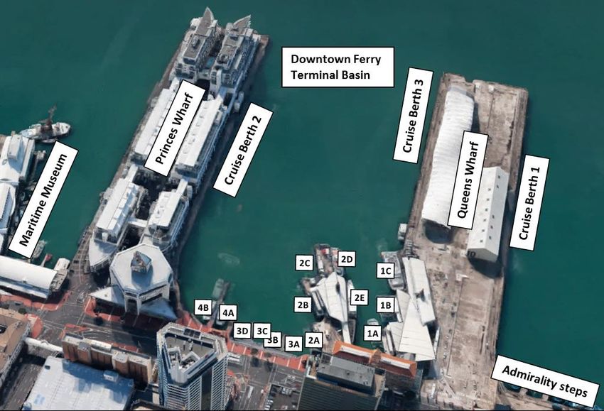
2. Introduction
This report has been prepared by Navigatus Consulting for Auckland Transport to assess
maritime issues, including navigational safety effects arising from the Ferry Basin
Redevelopment Stage 1 project.
The Downtown Ferry Basin Redevelopment is part of the wider Downtown Waterfront
programme of works being delivered for Americas Cup 36 (AC36). Under the Downtown
Ferry Basin Redevelopment Stage 1 six new ferry berths will be constructed along the
western edge of Queens Wharf and Pier 3 will be decommissioned.
The redevelopment of the Ferry Basin is being staged, with provision for the relocation of
current Pier 3 services being undertaken as part of the first phase of redevelopment as Pier
3 is nearing the end of life and is in need of redevelopment within the next 2-3 years. In
addition, use of the existing Ferry Basin configuration is nearing capacity and the provision
of new ferry berth infrastructure, as part of Stage 1, will allow improved efficiencies to be
delivered which will allow for expected service growth over the next 5 to 7 years, pending
completion of Stage 2 of the redevelopment.
Stage 1 of the proposed ferry basin redevelopment includes the construction, establishment
and operation of new infrastructure to provide for six berths adjacent to Queens Wharf West
and modifications to the existing ferry terminal building and immediate surrounds. The
proposed structures will occupy approximately 2,400 m2 of the CMA. The new berths are
labelled Piers A-F, with Pier A located closest to the ferry terminal building and Pier F
located towards the northern end of Queens Wharf. The proposal also includes the
demolition of the existing piles, pontoons and gangways located at Pier 3.
Stage 1 comprises the construction of:
Six new floating pontoon berths in a reverse saw-tooth arrangement.
Three new covered gangways providing access to the pontoons from Queens Wharf
West.
Associated maritime infrastructure such as fendering.
Power and water to all berths and sullage to two berths.
New landside infrastructure such as signage and ticketing.
A 210m long wave attenuator.
6
2.1. Development context
The following projects do not form part of the Downtown Ferry Basin Redevelopment project.
Navigatus is providing maritime advice on many of these projects, including the Queens
Wharf dolphins. However, they have been taken into account in the assessments of maritime
operations and safety.

2.1.1.     Downtown Public Space
Downtown Public Space is a new development proposed between Princess Wharf and
Queens Wharf, which is currently in concept design stage. The construction operation will
require demolition of existing piers and installation of new structures. Advice is being
provided by Navigatus to the Downton Public Space design team on how to ensure that it
does not create additional safety and operational risk to ferry operations.

2.1.2.     Quay St Seawall Works
A section of the seawall running along Quay Street in front of the Ferry Basin is to be
seismically strengthened. There are multiple construction approaches possible for the
proposed works to the Ferry Basin seawall section with each of those having both a landside
component and a limited construction zone on the seaward side.
A Maritime Safety Management Plan has been proposed by the applicant to maintain the
safety of maritime activities and navigation during the construction period.

2.1.3.     Queens Wharf Dolphins
Two cruise ship mooring dolphins are proposed to be installed off the northern end of
Queens Wharf. These works have little effect on the Downtown Ferry Basin, other than
extending the ‘restricted area’ and possibly also the southern boundary of 5 knot speed limit
offshore for ferries heading east and north-east by about 90m. A separate study carried out
by Navigatus for that proposal has concluded that this will have no material effect on ferry
passage times. However, it will have the effect of extending the effective queuing area prior
to entering the Basin.

2.1.4.     America’s Cup
The America’s Cup base facilities are proposed to be constructed in Freeman’s Bay to the
west of the basin.
The America’s Cup and its supporting events will likely cause a notable increase in
recreational traffic in the Waitematā Harbour. Much of this increase will be from vessels that
operate to and from the Westhaven facilities.1 Auckland has hosted America’s Cup races
and other marine events before. Given proper management of the entrance channel area
(under the normal oversight of the Harbour Master), there is little reason to suggest that the
interaction between the ferry activities and this increase in recreational traffic in the
immediate area of the Ferry Basin cannot be effectively managed.

1
 This may affect existing ferry operators such as Fullers, who may be impacted by changes to layover capability and servicing
of vessels.

                                                              7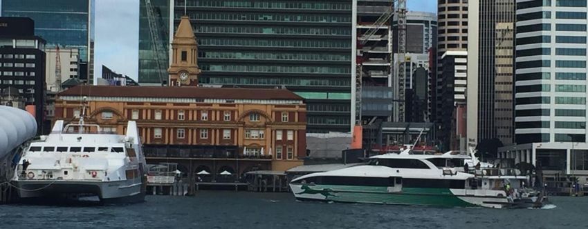
2.2. Operational Criteria
From an on-water operations perspective we identify the following key operational criteria for
new pier developments in the DFT basin - as set out in the following table:

                   Criterion                                    Origin

1. Safe: the terminal is safe for the operation    Required by both Health and
of ferry vessels, passengers, ferry personnel      Safety at Work Act (personal
and members of the public over the range of        injury) and Maritime Transport Act
likely operating conditions.                       (maritime safety).

2. Effective: the terminal provides for
throughput of the expected numbers of              Required for DFTB to play its part
passengers at peak times during and after          in the Auckland transport network.
redevelopment.

3. Reliable: the terminal is available and
usable under all conditions that ferry services    Auckland Transport requirement.
otherwise operate in.

4. Compatible: the terminal does not unduly
interfere with other port operations and vice      For example cruise ships to be
versa. Safety at the terminal is not put at risk   safely manoeuvred onto Princes
by other port operations nor does it put other     Wharf East.
operations at risk.

                                                     8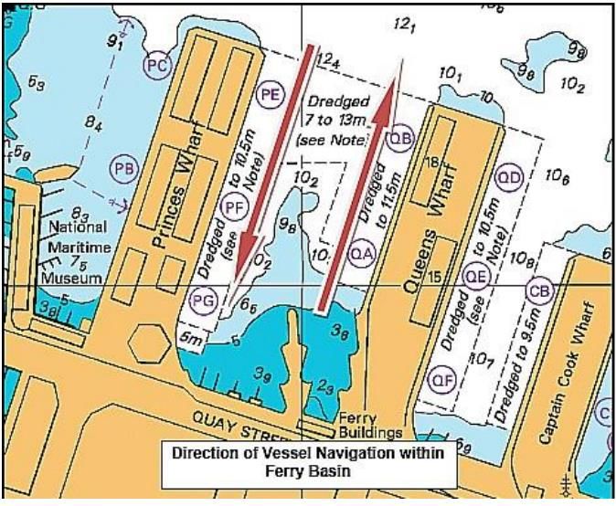
3. Existing environment

3.1. Activities in Basin
A range of current and future activities are planned for the Downtown Ferry Basin.

Current Activities                                                                                   Future Development Stage 1

           •                Ferry services                                                            •        Ferry Services

           •                Large cruise ships on Princes Wharf East                                  •        Large cruise ships on Princes Wharf East

           •                Bunkering of cruise ships                                                 •        Bunkering of cruise ships

           •                Other activities (Harbourmaster, Police,                                  •        Other activities (Harbourmaster, Police,
                            Coastguard)                                                                        Coastguard)

           •                Occasional ships on Queens Wharf West                                              -

                            -                                                                         •        Proposed ‘Downtown Public Space’

Key changes are that ships will no longer berth on Queen’s Wharf West, with that being
given over to new ferry berths. 2 In addition, an area of Downtown Public Space is proposed
in the area alongside Quay St as part of a separate project.

3.2. Demand for ferry services
Demand is seasonal, picking up over the summer (Figure 3.1 and Figure 3.2).3
Figure 3.1 Auckland ferry patronage by year                            Figure 3.2 Auckland ferry patronage by month (Jul 17 – Jun
                                                                       18)
                                                                                               700
                     6000                                                                                               Summer peak
                                                                                               600
                                                                       Patronage (thousands)

                     5000
    Patronage (thousands)

                                                                                               500
                     4000
                                                                                               400
                     3000                                                                      300
                     2000                                                                      200
                     1000                                                                      100
                            0                                                                   0
                                2006 2008 2010 2012 2014 2016 2018                                    Jul-17       Oct-17       Jan-18     Apr-18

2
  This includes passenger ferries, which currently layover in this area. An alternative solution has not yet been confirmed for this
activity.
3
  Auckland Transport Public Transport Patronage Data from 2005 – August 2018. https://at.govt.nz/about-us/reports-
publications/at-metro-patronage-report/

                                                                                                9
3.3. Environmental conditions

3.3.1.      Wind and currents
The prevailing wind for the Auckland region is south-westerly, however the wind blows from
the north-west through to the north-east a proportion of the time. Wind from the largely open
west, north and east directions is only partly disrupted by the Stanley Point shoreline –
otherwise these directions are largely open with a notable reach to the north-west.
Conversely, the land form and high-rise buildings of the city generally shelter the basin from
southerly winds.
Figure 3.3 shows a wind rose from 7 years of record at Bledisloe Wharf.4 The ferry basin is
open to winds from the northerly quarters, which occur 29% of the time (Table 3.1) Winds
come from the northerly sector and exceed 20 knots for approximately 0.7% of the time.

Table 3.1 Northerly sector winds (all hours) at Bledisloe Wharf (2010 - 2017)
    Wind speed
                         Percentage of time
     (knots)
      0 to 5                             7.9%
      5 to 10                           10.6%
     10 to 15                            7.3%
     15 to 20                            2.5%
     20 to 25                            0.6%
     25 to 30                            0.1%
     30 to 35                           0.01%
       35 +                                0%
                                            29%

Figure 3.3 Wind rose for Bledisloe Wharf (2010 - 2017)

4
  Bledisloe Wharf is the wind recording site that is closest to the basin. The available 7 years of record is considered
appropriate for assessing general wind conditions in the outer part of the basin. Wind directions and strengths in the inner basin
are influenced by sheltering and by wind funnelling by buildings and streets, Sheltering from wharves varies with proximity and
the state of tide.

                                                               10
The above data are taken to be indicative of likely wind conditions in the Ferry Basin. Winds
in the inner basin are influenced by the buildings, with wind funnelling through the gaps
between them. As a consequence, wind directions and speeds in the inner parts of the basin
can be quite different to the outer parts. Pier 1 is particularly sheltered.
There are no significant tidal currents in the basin. However, the operation of tug and cruise
vessel propulsion (e.g. bow thrusters and Azipods) in the basin or at adjacent basins can
generate significant localised currents and eddies.
3.3.2. Waves and wake
The Waitematā harbour is a relatively busy harbour with large numbers of commercial ferries
and recreational craft transiting eastward and westward as well as ferries operating across
channel. These vessels create wake that can combine with the natural fetch or wind-against-
tide effects to create unsettled surface conditions.
Queens Wharf and Princes Wharf are piled structures. While shoals have built up under
these wharves they provide little or no attenuation of wave action, especially at high tide
when the shoals are more fully submerged.
The basin is mainly exposed to waves originating from the northern quarter with a north-west
fetch of 3-4 km from Shoal Bay. Waves generated by easterlies and westerlies in the
Waitematā may also refract around the Wynyard Reclamation to the west and the Port of
Auckland reclamations to the east (see Coastal Effects Assessment (Tonkin & Taylor)).
Refracted waves partially pass under and around Princes and Queens wharves, mainly
affecting the seaward parts of the ferry basin
Shoal Bay
Ferry basin
Figure 3.4 Site location (Chart NZ 5322 Auckland Harbour East)
113.4. Visibility
Given the ferries naturally approach and depart the basin area at right angles to the natural
flow of harbour traffic and given the structures on the wharfs plus the low aspect typical of
recreational craft, there is an inherent issue of visibility. This accounts for the ‘restricted area’
immediately off the Basin put in place by the Harbourmaster.5 The purpose of this restricted
area is to keep harbour traffic further offshore than it may otherwise be and in doing so
reduce the change of traffic conflict. It is understood that this area has been largely effective.
This restricted area will extend a further 90 or so meters to the north if and when the
proposed Queens Wharf dolphins are constructed. That said, as the dolphins will be
connected by walkways, some sight lines between the wharf and the dolphins may become
available to skippers approaching from the east.
A key restriction on visibility off of the ferry basin can also occur when large cruise ships are
berthed at either Princess Wharf east, Queens Wharf west and to a lesser extent, Queens
Wharf east.
Once within the basin, visibility is largely unobstructed and the basin area is generally well lit
at night.
3.5. Regulatory
3.5.1. Maritime Rules
All vessels in the harbour are subject to maritime rules and regulations. At the national level
these are issued by Maritime NZ as Maritime Rules. In particular the following rules apply:
Maritime Rules Part 22 – Collision Prevention
Maritime Rules Part 90 – Pilotage
Maritime Rules Part 91 – Navigation Safety Rules
Harbourmaster and Bylaw
In addition, Part 33 of the Maritime Transport Act 1994 gives the Harbourmaster powers to
manage the safety of maritime activities. Auckland has appointed a harbourmaster for the
harbour and other waters in the region. The harbourmaster not only sets local rules for
maritime safety but also enforces those rules. Local rules set by the Harbourmaster are
found in the Auckland Council Navigation Safety Bylaw 2014 and Controls (Auckland
Council 2014).
In addition the harbourmaster has authority to give directions to masters of vessels for
maritime safety purposes and has powers to directly enforce those directions if masters do
not comply. Those directions can be specific, applying to a particular vessel, or generic,
applying to all vessels of a defined class. Generic directions given by the Harbourmaster are
found in Harbourmaster Directions issued by Auckland Harbourmaster (1-16, 2-16, 4-16).
5
Navigation Safety Bylaw 2014 and Controls (Auckland Council)
123.5.2. Harbourmaster Directions – Ferry Basin Operation
Harbourmaster’s Direction 1-16 covers the Downtown Ferry Terminal Basin (Auckland
Transport Harbourmaster). This Direction includes a restriction on movements of vessels
over 500 gross tonnage between the weekday hours of 7:30am to 9:00am and 4:30pm to
6:00 pm (no vessels greater than 500 gross tonnage shall manoeuvre within the downtown
ferry terminal basin or operate any propulsion or manoeuvring equipment).
This requirement effectively prohibits the movement of any cruise ships or bunkering barges
in the basin during the specified curfew periods.
There are Navigation Safety Operating Requirements6 for the basin area. Vessels are to:
Proceed at a safe speed
Travel in an anti-clockwise direction
Be mindful of wake and aware of propeller wash
Figure 3.5 Map showing the required direction of vessel traffic in the ferry basin (Auckland Transport)
6
Harbourmaster’s Office. Auckland Downtown Ferry Terminal Basin. Navigation Safety Operating Requirements (15/04/2016).
134. Maritime traffic
4.1. Ferries and Ferry Services
Scheduled ferry services in Auckland are currently provided by three operators. Most of the
routes are provided on contract to Auckland Transport, while some are unsubsidised.
The Devonport service currently has two primary vessels operating. One is the Kea, which is
a catamaran (27m) of a double-ended design operating on the Devonport run. This type of
design is used to save transit time by avoiding the need to turn around at each end of short
runs.
The Fullers Waiheke ferry service has two primary vessels operating, which are the largest
catamarans of the Fullers fleet. There are various other smaller ferries operated by a number
of companies providing services to and from Pine Harbour, Gulf Harbour, West Harbour,
Bayswater, Half-Moon Bay, Birkenhead/Northcote Point, Stanley Bay and
Hobsonville/Beachhaven. Less regular services run to other locations inshore and in the
near-coastal area including islands in the Hauraki Gulf.
Most of the ferries are of a catamaran design of light aluminium construction, which allows
them to carry passengers and light loads at high speed with moderate engine sizes and
reasonable economy. Due to their light construction the ferries need to be handled carefully
on berthing as heavy contact can result in significant damage to the vessel. Fast ferries tend
to be more affected by wind than traditional deep V high speed designs as they typically
have only shallow draught but retain the a large superstructure and so more readily drift to
leeward under the effect of wind.
However, having propulsion units in each hull makes catamaran ferries inherently more
directional control than traditional single and multi-shaft deep V designs. Fine control of
thrust can be an issue as many of the fitted propulsion systems do not readily allow low shaft
speeds with the engine direct geared to the shaft. Some ferry designs have controllable pitch
propellers which provide finer control during slow speed manoeuvring. SeaLink Pine Harbour
Chipper vessels have jet propulsion systems system that provides excellent manoeuvrability.
Fast ferries operating in Auckland Harbour are not generally fitted with bow thrusters.
Figure 4.1 Capricornian Surfer Turning After Sternwards Departure from Berth 1B
144.2. Ferry traffic volume
The Downtown Ferry Basin carries nearly 400 scheduled ferry movement on weekdays
(Winter timetable). The main customer base is commuter traffic, resulting in a distinct profile
with morning and evening peaks (Figure 4.2).
35
30
Movements per half hour
26
24
25 22
20 Morning and evening
commuter peaks are
15 12
evident in Auckland
10
5
0 Weekday total 386 movements
11:00 a.m.
11:00 p.m.
5:00 a.m.
7:00 a.m.
9:00 a.m.
1:00 p.m.
3:00 p.m.
5:00 p.m.
7:00 p.m.
9:00 p.m.
7
Figure 4.2 Auckland Downtown Ferry Basin – Midweek Winter Scheduled Movements
There are usually no ferry movements in the basin between the last service (which is
currently the Devonport service in the early hours of the morning8) until around 15 minutes
before the first Devonport service of the day.
4.3. Basin flow and traffic observations
The following comments are direct observations of ferry basin operation during morning and
evening peaks by Kevin Oldham of Navigatus Consulting in mid-2018 and from time-lapse
video recordings of basin operations by Navigatus Consulting in September 2018. In all
cases there were no cruise vessels on Cruise 1 or Cruise 3, no bunkering operations and all
piers were serviceable and in use.9 Wind conditions were generally light with good visibility.
Although ferry patronage is higher in summer (Figure 3.2), the number of ferry movements is
expected to be broadly similar to our observations.
Circulation: the anticlockwise circulation pattern was generally well maintained by masters
(Figure 4.3a) especially for vessels which execute a turn to berth sternwards. There are two
more or less consistent exceptions to the pattern of movement. The Kea usually arcs into
through the middle third of the basin on arrival into Berth 1B. Sometimes the Kea diverts
closer to Queens Wharf to allow vessels to exit Pier 1, thereby creating an impression that
its natural path is to arrive along Queens Wharf. The other exception is the Bayswater ferry
which arrives in the northwest corner of the basin and berths bow in at Berth 1A in the
southeast corner. This naturally leads it to travel on a diagonal path across the basin,
however when observed to pause for traffic this ferry always moved west to allow circulation
compliant passing movements to occur.
7
Data from published timetables on ferries’ website. 16 July 2018. The summer timetable will have a higher level of movement
compared to this winter data.
8
The timing and service of the last vessel may changes as service spans extend to other destination.
9
Cruise vessel arrivals are more numerous in summer (there are 9 cruise vessel arrivals scheduled for Princes Wharf in
February 2019). See Figure 4.8 and discussion in Section 4.4.
15Figure 4.3 Tracks of Ferries Using Downtown Ferry Basin
10
a) Anticlockwise Circulation b) Existing Approach to Berth 2B
Approach to Berths 2A and 2B: in some conditions the existing approach to Berth 2B (see
Figure 4.6 for map of berths) passes close to the ends of Piers 4 and 3 (Figure 4.3b).
Approaches to Berth 2A appear to be well clear of the outer extents of Piers 3 and 4.
Queuing: on arrival vessels queue outside the basin (off the end of Princes Wharf) and
within the basin, passing slowly down Queens wharf or by standing off the end of Pier 2. On
departure vessels sometimes queue just off Piers 3 and 4.
Passing in Queue: on occasion on arrival a smaller ferry heading for Piers 3 or 4 will
overtake a larger ferry ahead which is waiting for berths on other piers, by passing to the
west of the larger ferry (i.e. on an outer circulation path).11
Priority for Devonport Ferries: The Devonport ferries are usually given priority by other
traffic and navigates in a manner different to the usual counter-clockwise circulation
pattern.12 However, a situation where the Kea ferry arriving along Queens Wharf (non
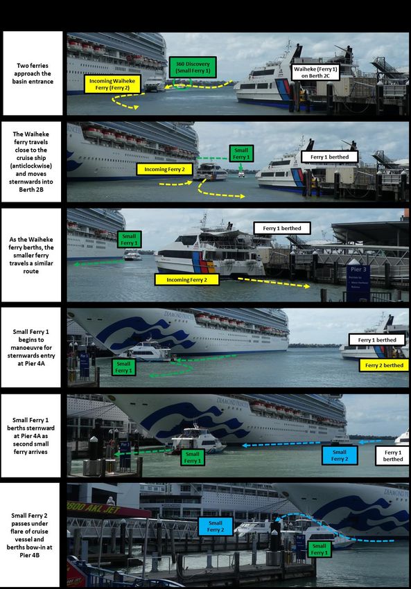
counter-clockwise) needs to wait in the basin for Berth 1B to come clear is illustrated in
Figure 4.4 and in the sequence of photographs in 0.
10
Looped track to outer end of basin and return is a non-standard but compliant manoeuvre for training purposes.
11
It is understood that such manoeuvres are arranged by VHF at the time between the masters of the two vessels concerned.
12
Confirmed by Fullers ferry masters.
1613
Figure 4.4 - Kea waiting alongside Queens Wharf for Berth 1B to Clear
Berthing on Piers 1, 3 and 4: under the ideal conditions, making ferries fast once alongside
in the berths on Piers 1, 3 and 4 took only 20 seconds on many occasions. First passengers
typically stepped off the vessel around 10 seconds later (30 seconds total).
Berthing on Pier 2: from the time when the head line is taken on the north-east bollard, the
Waiheke ferries arriving at Berths 2B and 2C take approximately 50-60 seconds to
manoeuvre alongside, followed by a further 30 seconds to move aft into the berth. Making
the vessel fast can take over a minute more, then positioning the hydraulically actuated
gangway can take a further minute. The first passengers step off the vessel several minutes
after the head-line is taken.
Simultaneous Movements: multiple vessels may be moving through various points in the
basin at any one time. For example, Figure 4.5 shows three vessels moving or manoeuvring
simultaneously in a limited area of the basin:
vessel manoeuvring onto Pier 2
vessel manoeuvring towards Pier 1
vessel departing Pier 3
Figure 4.5 - Simultaneous Manoeuvring of Ferries in Inner Downtown Ferry Basin
Ferries are an integral part of the Auckland public transport system with a range of routes
supporting regular services to and from the ferry terminal. As a result there are nearly 400
scheduled ferry movements each weekday. The ferry basin is therefore busy with vessel
movements, especially in peak commuter passenger periods in the morning (0630-0930)
and evening (1530-1830) (see Figure 4.2). In addition, cruise ships occasionally berth on
Princes Wharf and Queens Wharf constricting the water available for ferry movements.
13
Refer Appendix A for sequence.
174.4. Cruise Ships
The aerial view below shows the cruise ship berths and smaller piers. Cruise ship berths 1
and 2 are in frequent use over summer, while Cruise Berth 3 is able to be used if required for
cruise ships or for other vessels such as visiting warships. Cruise ship visits peak over
summer. It is understood that cruise ship operation will continue on Cruise Berth 2 for at
least the next few years, so the ferry basin needs to operate with current and near-term
levels of traffic with cruise vessels on Berth 2.
Initially it was proposed that Cruise Berth 3 was to be retained, but as the Ferry Basin
Redevelopment project developed it became apparent that most or all of Queens Wharf
West would be required for relocating ferry berths. In early June 2018 Auckland Council
agreed with Ports of Auckland that use of Cruise Berth 3 could be discontinued after April
2019 if Queens Wharf West was required for the Downtown Ferry Basin redevelopment.
As noted before, two mooring dolphins are proposed to be constructed to the north of
Queens Wharf.
Figure 4.6 Map of berths in use in the Downtown Ferry Terminal Basin
The berthing of cruise ships on Princes Wharf narrows the available water space in the
basin. Careful manoeuvring is required to access to Berth 4B, with ferries sometimes
passing under the bow flare of the cruise ship (Figure 4.7).
1814
Figure 4.7 Ferry Arriving at Berth 4B Passes Under Bow Flare of Cruise Ship Berthed on Princes Wharf
No ferry movements can take place while a cruise ship is berthing on Princes Wharf East.
Departing cruise ships leave the basin relatively quickly and with little disruption.
The figure below shows the published cruise schedule for vessels arriving at Princes Wharf.
The summer months are busier, and no cruise arrivals appear to be scheduled for the winter
months (June through August/September)
Princes Wharf Cruise Vessel Arrivals
10
Summer
8
Count of arrivals
6
4
2
0
Sep 2018Oct Nov Dec Jan Feb Mar Apr May Jun Jul Aug 2019
15
Figure 4.8 Cruise schedule for Princes Wharf
4.5. Bunkering of Cruise Ships
Auckland is one of only two places in New Zealand where cruise ships can “bunker” (refuel).
Services are provided in Auckland by Seafuels (Awanuia) and Stolthaven (barge Marstel).
Seafuels refuels about ten cruise ships a year at Princes Wharf. Stolthaven bunkers three to
five times a year in the basin (at both Princes East and Queens West (which has smaller
cruise vessels)). Cruise ships must be refuelled from amidships as that is where the
connections are located.
14
Appendix A for sequence of photographs.
15
Cruise schedule published by POAL, 19 September 2018. www.poal.co.nz
19Awanuia
3900 DWT Bunker Tanker
16
Figure 4.9 MV Awanuia
General Information Cargo Capacities
Cruise
Yard ship bunkering interaction risks HFO
Yardimci Shipbuilding, withcargo
ferry operations
tanks 3260 m³ are considered by Seafuels to
17 Turkey MDO cargo tanks 843 m³
be
Builtlow as: 2009
Port of Registry, Flag Auckland, New Zealand Load/Discharge Equipment
Call Sign
traffic is limitedZMA to 5 knots in the basin.
2137 HFO Cargo Pumps 2x Twin screw (Bornemann)
Official Number 876495 Max discharge 800 m³/h
Classification
ferriesSociety
are relatively
ABS small and of lightweight aluminium
MDO Cargo Pumps construction,
2x Deepwell (Marflex) whereas the
IMO No. 9458042 Max discharge 160 m³/h
Awanuia has512219000
MMSI No.
larger dimensions and steel double hulled.
Cargo Crane 1.5 mt at 22 m
Awanuia is double hulled with 1.2 mBoom gap between outer
Hoses 6" line forand
HFO inner hulls, so very low
Dimensions 4" line for MDO
likelihood
Length Overall of penetration
79.9 m to inner hull in a slow
Provisions Crane speed collision
3.0 mt at 6.5 m with a light aluminium
Beam, Moulded
ferry. 15.0 m
Max Operating Draft 7.32 m Machinery
GRT/NRT
Awanuia only2747 carries HFO and Diesel,
mt/1180 mt which is difficult
Main Engines to 6L20
2x Wartsila ignite, so explosion risk is very
Horsepower 2900 BHP
low.
Accommodation 10x1 = 10 berths ASD Propellers 2x Wartsila CS175-SWO-K
Bow Thruster Schottel STT330 TLK,
The Marstel
Capacities dumb barge is also double hulled (72m long,
& Performance and 17m wide when including the
300 kW
Fuel 119,600 litres Auxiliary Generator 1x MAN D2842 LE 301
tug alongside). 165,000 litres
Potable Water Emergency Generator 1x MAN D2866 LE 203
Sewage Treatment Plant
The harbourmaster requires bunkering Communication
Max Speed 11 knots notification,Equipment
including a risk assessment and
precautions to be put in place (Clause 52 of the Auckland Council Navigation Safety Bylaw
Inmarsat Sat C
2014 and Controls) (Auckland Council 2014).
Some of the controls in place include:
Barge Marstel and Sea-Fuels Bunker ship Awanuia cannot be carrying out Bunker
Operations in the ferry basin at the same time
Bunkering operations cannot be moving in or out of the basin during specified times
(peak ferry hours)
Bunkering operations cannot be active outside of daylight hours
A tug must be attached to the dumb barge at all times during bunkering operation
4.6. Waitematā Harbour
Auckland (Waitematā) Harbour is used extensively for a range of commercial and
recreational activities. Aside from cruise ships, vessels navigating the water in the vicinity of
the ferry basin range from coastal oil tankers of up to 183 metres overall length (LOA) to
ferries carrying people and vehicles, as well as a wide variety of private and commercial
yachts and motor craft, alongside kayaks and, to a lesser extent, stand up paddleboards.
16
Length Overall 80m, Beam 15.0m,Gross Tonnage: 2,747. Cargo Capacity 3,260 m3 HFO, 843 m3 MDO
Source: Seafuels (2009)
17
Pers. Comm
20Westhaven Marina to the west of Wynyard Point berths nearly 2,000 small craft while other
boat harbour and facilities accessed by the same waterway add significantly to this figure.
That said, a large proportion of the recreational craft berthed in the marina get limited use.
Many boat races, resulting in clusters of sailing yachts transiting together, are held in the
immediate area of the harbour.
Whilst the survey indicated a moderately busy harbour, the survey was carried out over one
weekend in late spring. Higher levels of traffic can be expected in the peak summer season
develops.
In particular, the harbour sees very heavy marine traffic for special events such as the
Auckland Anniversary Regatta held annually around the end of January. Cross-harbour
swim events also occur in the summer months.
4.7. Freemans Bay
Freemans Bay maritime facilities consist of Wynyard Wharf to the west, Princes Wharf to the
east and North Wharf, Halsey Wharf, Western Viaduct Wharf and Hobson Wharf to the south
of the bay.
4.8. Viaduct Harbour
The Viaduct Harbour is formed of two basins, the Outer and the Inner, connected by a
channel spanned by a lifting bridge. The Inner Basin is particularly sheltered and used as a
marina by a wide range of private and charter vessels, most of which are serviced by
pontoons. A mix of private boats, as well as charter and commercial fishing vessels, use the
Outer Basin. As with the inner basin, most vessels are serviced by pontoons. The maximum
length of vessel allowed in the Viaduct Harbour is 55 metres.
Figure 4.10 Figure from America’s Cup Marine Traffic Survey for Resource Consent Application, Wynyard
18
Hobson
18
Beca Ltd, April 2018. Prepared for Panuku Development Auckland and the Ministry of Business Innovation and Employment
214.9. Interactions with Port and Harbour Activities
Port activities on adjacent wharves seldom have an effect within the ferry basin. The main
source of other interference to ferry operations in the basin is recreational users. Almost
every day that a cruise ship is on PWE one or more recreational vessels (e.g. kayak, power
boat) will enter basin to farewell a passenger. In addition yachts engaged in racing often
cross the mouth of the basin, within the 50m basin zone19, (e.g. when working to windward
against an ebb tide).
There is signage on the ends of the wharfs relating mainly to the area being customs
controlled, rather than providing for navigational safety. The signs appear to be routinely
ignored by some recreational boat users.
19
The basin zone declared by the Harbourmaster extends 50 metres beyond the ends of Queens Wharf and Princes Wharf.
Harbourmaster’s Office. Auckland Downtown Ferry Terminal Basin. Navigation Safety Operating Requirements (15/04/2016).
225. Navigational effects assessment: operational phase
5.1. Method of Assessment
This navigational effects assessment considers the reverse sawtooth layout. Navigatus was
involved in the selection process including three simulation sessions at the New Zealand
Maritime School maritime simulator and developing a queuing model. Navigatus has also
advised on the maritime aspects of construction activity. The process is summarised in
Appendix B, presented in the Project Context and Options Assessment report (Tonkin &
Taylor), and in several Navigatus memos.20
Under the right conditions, the right equipment and with enough time, maritime operations
can be safely undertaken in tight quarters. As the space available for manoeuvring gets
tighter then, to maintain safety, the operation becomes slower, and becomes more
constrained in terms of the wind and wave conditions in which it can operate. The limits of
those conditions depend closely on factors such as manoeuvrability of the vessel skill of the
crew, berthing procedures, and fendering systems. For these reasons there are few hard
and fast rules as to what is, or is not, acceptable.
A commuter passenger ferry service needs to be reliable under a wide range of weather
conditions. The AT Ferry Manager has defined that as being operation under all conditions
that the ferries would otherwise operate in.
It is the stronger weather conditions that define the operating conditions in which the ferry
basin operation needs to be assessed. It can be expected that passengers will tolerate some
slow down and delays in services during heavy weather, and occasional cancellations in the
wildest conditions, but generally expect a reliable service at other times.
Given the absence of hard and fast operational parameters, the navigational effects
assessment has been undertaken against the operational criteria set out in Section 2.2.
The assessment process has included:
Direct observations of operations in the existing ferry basin
Time-lapse video footage of existing ferry basin operations
Bridge trips on ferries in Auckland and Sydney to observe operations from the ferry
master’s point of view
Discussions with ferry masters and operators
Discussions with the Auckland harbourmaster
Discussion with refuelling barge operators and Ports of Auckland
Comparison to existing ferry basin operations and to Circular Quay in Sydney
Where, in this assessment we recommended particular controls, our assessment is based in
those controls being adopted and effectively implemented.
20
These are: On-water Ferry Simulations and Queuing Model July 2018; Outcomes of Navigational Simulations 2 (1 and 2
August 2018); Outcomes of Vessel Manoeuvring Simulation 3 (28 August); and Maritime Aspects of Berth Layout Selection (10
September 2018).
235.2. Simulation 3
5.2.1. Simulation 3 Purpose and Outline
21
Figure 5.1 Reverse sawtooth layout
The purpose of Simulation 3 was to determine if the ‘reverse sawtooth’ layout is practicable
from a vessel manoeuvring and berthing perspective. The Simulation is reported in the
memo-report (Outcomes of Vessel Manoeuvring Simulation 3 (28 August)).
A key difference to the prior simulation sessions was that the vessel was driven by Capt
Buckens of the New Zealand Maritime School (NZMS) as opposed to local ferry masters.
Capt Buckens is highly experienced master with experience in cruise ship operations but not
ferries. However, the smaller ferries using the Downtown Ferry Basin are similar to cruise
ship tenders of which he has experience.
A second difference was that all simulated runs were recorded and evaluated with no
familiarisation period. This was partly undertaken in recognition of Captain Bucken’s general
proficiency in driving a variety of vessel types in the simulator. While the need to employ
Capt Buckens arose initially out of logistical circumstances the situation did allow testing of
how well the layout catered for handling errors during an approach, as might occur in real
operations with a less proficient master.
5.2.2. Key Learnings
Key learnings from Simulation 3 were:
1. The reverse sawtooth layout is practical for vessel manoeuvring and berthing during
what is likely to represent a worst-case condition in the basin – namely northerly wind
conditions.
2. Bow-in (bow-north) berthing approaches to the berths were well-controlled with little
chance of collision with vessels in adjacent berths.
3. The existing anticlockwise circulation pattern was maintained and found practical.
4. In some situations and unless actively coordinated, conflict could arise with vessels
operating to and from the southernmost two saw-tooth berths interfering with vessels
approaching or departing Pier 1.
21
Allocation of large and small berths may change from that shown.
245. The simulation runs identified potential issues with vessels backing from the two
most southern berths on departure. However, this is not the departure procedure that
would be employed in fresh northerly conditions. Appropriate use of mooring lines will
allow “springing off”22 to exit the berth.
5.2.3. Ferry Operations
The key conclusion of Simulation 3 is that the ‘reverse sawtooth’ layout enables safe vessel
manoeuvring during strong northerly wind conditions. These conditions are considered to
represent a worst case for vessel handling in the basin.
The reverse sawtooth layout, used by all vessels bow-in allows the existing anticlockwise
ferry circulation pattern in the basin to remain. Consistent circulation of vessels assists with
maintaining safe ferry operations.
We discuss the potential for issues with congestion below but do not recommend one
particular solution as these are operational decisions to be made at the time by Auckland
Transport in consultation with ferry operators. No doubt the best means of resolution will
change over time, responding to changing factors such as ferry traffic, vessel capability and
technological developments. Whatever solutions are selected, their effect on protecting
maritime safety will need to be to the satisfaction of the Harbourmaster, acting under
authority of the Maritime Transport Act.
Vessels manoeuvring into and out of the southernmost sawtooth berths will potentially
conflict with vessels turning to go astern into Pier 1, or reversing out of Pier 1 if they have
entered a Pier 1 berth bow in. This will require additional care and, as a result, this area may
become congested at times. Congestion in this area is a potential issue with any layout that
places berths on the southern part of Queens Wharf.
Congestion creates two risks: maintaining timetable and collision between vessels. A range
of options is available to address congestion. Such options include:
1. reserving most southern sawtooth berth for smaller and more agile ferries – so as to
minimise the time taken for manoeuvring in this area, (this would also put them in a
more sheltered part of the basin), or
2. reserving the southernmost sawtooth berth for uses that do not require frequent
access in peak periods, such as layover and sullage pump-out, and/or
3. moving the higher frequency Devonport service out of Pier 1.
Other options may also be practical and effective. Whatever solutions are selected, their
effect on protecting maritime safety will need to be to the satisfaction of the Harbourmaster,
acting under authority of the Maritime Transport Act.
The Devonport Ferry currently enters the basin through the middle third and diverts east to
pass if it encounters an oncoming vessel. Once the reverse sawtooth berths are built such a
manoeuvre would take the Devonport ferry closer to the berths and potentially to operating
ferries which would not be recommended. Instead it is recommended that the Devonport
22
This springing manoeuvre enables vessels to depart the sawtooth berths on an appropriate heading without being taken by
the wind towards Pier 2 or into the water space of Pier 1. Springing off is a well-known boat manoeuvre that ferry masters can
be expected to be familiar with.
25ferry stays in the middle third of the basin or diverts partly to the west to the extent as
required to allow safe and circulation-compliant passing manoeuvres to take place.
In summary the ‘reverse sawtooth’ layout, used bow-in, is preferred over the other options
considered. Congestion for Pier 1 manoeuvring is a downside to locating any berths on the
southern end or Queens Wharf. In our view this issue can be effectively managed through
the Harbourmaster’s powers under the Maritime Transport Act.
5.2.4. Manoeuvring room
The simulation runs identified potential issues with vessels backing from the two most
southern berths on departure. However, this is not the departure procedure that would be
employed in fresh northerly conditions. Appropriate use of mooring lines will allow “springing
off” to exit the berth (Figure 5.2).
Figure 5.2 - Springing Off Sawtooth Berth
1
2
Bow
swings away
from berth
Stern springline
prevents Cast off
sternward stern
movement springline
Port engine when clear
astern ahead.
Engage engines
to move ahead
This springing manoeuvre enables vessels to depart the sawtooth berths on an appropriate
heading without being taken by the wind towards Pier 2 or into the water space of Pier 1.
Springing off is a well-known boat manoeuvre that ferry masters can be expected to be
familiar with.
We conclude that, while the simulations appear to show risks for vessels departing the
southernmost berths of the sawtooth, those risks can be mitigated through appropriate
departure procedures for the wind conditions. This assessment assumes that such
procedures will be implemented voluntarily by the ferry operators, while noting that they can
be imposed by the harbourmaster if necessary.
265.3. Assisting situational awareness
It is recommended that assistance is provided to ferry masters to reduce the risks of collision
with other vessels in the basin. The issue is that the Ferry Basin is a restricted area of water
with many movements. “Situational awareness” refers to knowing what is going on around
you and is a vital component of navigational safety.
It is difficult for a ferry master to acquire sufficient situational awareness at times. Acquiring
full situational awareness is particularly difficult on departure as the vessel is situated right in
the basin and there are likely to be blind spots due to factors such as the arc of visibility from
the bridge, and obscuring of views by wharfs and ferry traffic. Departing a berth is also a
busy time for the ferry master so attention may become absorbed on other aspects of that
task, especially if there are any additional unusual elements or occurrences during berth
departure (e.g. late passenger flagging ferry, weather conditions, radio traffic).
For clarity the ferry master is at all times solely responsible for prudent seamanship and
collision avoidance, but it is appropriate to provide some form of assistance. Options for
such assistance include:
additional crewman stationed to maintain situational awareness of other vessels by
direct observation and to inform the master as appropriate.
electronic aid with a detailed view of basin showing the ferry master the position,
movement and recent track of other vessels23
electronic or other water space control aid that automatically assigns right to depart
berth
real-time ferry Basin Control service.
Maritime safety is a Maritime Transport Act matter and any solution needs to be to the
satisfaction of the Harbour Master. This assessment is predicated on the implementation of
a suitable solution to provide situational awareness assistance to ferry masters to the
Harbourmaster’s satisfaction.
23
Position may be derived from AIS, a radar system established in the basin, or other means.
27Figure 5.3 Basin Control Room at Circular Quay, September, 2018. (Photo Kevin Oldham)
5.4. Pattern of Circulation
Our assessment is that the Auckland Ferry Basin is too narrow and has too much other
activity in the small space (e.g. cruise vessels and bunkering) to adopt a Circular Quay
north-south style rule for ferry movements. The proposed reverse sawtooth works well with
the existing circulation pattern but also locks it in for the life of the berthing pontoons.
In summary our view is that, while the reverse sawtooth effectively locks in an anticlockwise
circulation pattern, the existing circulation pattern is a successful and safe mode of operation
in this confined area of water and should be retained.
5.5. Comparison to Circular Quay
A comparison between the Downtown Ferry Basin and Circular Quay, the hub of the Sydney
ferry network, is provided in Appendix C.
In summary ferries operating on Sydney Harbour carry three times as many ferry
passengers as in Auckland with just 70% more ferry movements through Circular Quay. The
peak numbers of ferry movements are similar (Figure 5.4).
28Movements per half hour 35 32 32
30
26 26
25
Sydney ferries
20 carry more
tourist traffic
15
10
5
Weekday total 666movements
0
11:00 a.m.
5:00 a.m.
7:00 a.m.
9:00 a.m.
11:00 p.m.
1:00 p.m.
3:00 p.m.
5:00 p.m.
7:00 p.m.
9:00 p.m.
24
Figure 5.4 Sydney Circular Quay - Midweek Scheduled Movements
Circular Quay is located in Sydney Cove which also hosts the Overseas Passenger Terminal
(OPT). Sydney Cove sees more cruise ship activity than the Auckland Downtown Ferry
Terminal but also has significantly more water space.
Comparison to Circular Quay comparison finds that the Downtown Ferry Basin is almost as
busy in peak periods, while operating from a more constrained water space. Circular Quay
operates at a noticeably higher tempo with many aspects of design and operation being
oriented towards speed of passenger movement.
We conclude that differences in the berthing layout designs, water space constraints and
methods of operation are such that direct overall comparison between Circular Quay and the
proposed Reverse Sawtooth layout is inappropriate. However, it is apparent that Sydney
operates a higher tempo of operation.
Figure 5.5 View of Circular Quay, September 2018 (Photo Kevin Oldham)
24
A movement is either an arrival or departure. Each berthing consists of two movements. Excludes unscheduled non-
passenger movements such as for positioning fleet, layover, sullage pump out, fuelling and maintenance. Assessed from
internet-published winter timetables for a Wednesday in September 2018. Excludes services with departure frequency less
than twice a day.
295.6. General public and passenger safety
Assistance provided to ferry masters will help reduce the risk to members of the public who
are in or on the waters of the Basin (this may be by watching for unauthorised water uses, by
warning ferry masters, and if necessary stopping ferry operations).
Differential movement between vessels and pontoons may give rise to issues of passenger
safety during embarkation and disembarkation, particularly for smaller vessels in the outer
berths. This will be partly addressed by the proposed loading ramps but also requires careful
consideration in the final layout of berths and allocation of services to berths.
5.7. Current Ferry Operations at Piers 3 and 4
Existing operations in the ferry basin are described in Section 4. In summary the basin is
busy, with a high number of movements of ferries, many of which relatively small. The basin
gets congested at peak times, with ferries queuing outside and inside the basin waiting for
berths to clear.
Once on the berth the tempo of operations is quick on the berths on Piers 3 and 4 and
smaller ferry services, with the first passenger leaving the vessel within 30-40 seconds of the
vessel taking the first mooring line on.25
Ferries generally comply well with the anticlockwise circulation pattern. An exception is the
Devonport ferry, which comes through the middle third of the basin and diverts east to
Queens Wharf when oncoming ferry traffic is encountered. Such a counterflow pattern of
movement on the arrival leg may be necessary for time-keeping on a short and higher
cadence run, but is also counterintuitive from a safety perspective. This poses a risk on
departure for services from Piers 3 and 4 to destinations east of the basin as those services
exit the basin closer to Queens Wharf and must cross the Devonport ferry path at some
point. While crossing paths is less desirable it is both common and manageable. Managing
the risks arising from such crossings are governed by Maritime Rules Part 22 – Collision
Prevention.
The berths at Piers 3 and 4 are close to shore and are reasonably sheltered, especially
during lower states of the tide. It is usually the case that a service will be cancelled due to
wind and wave conditions en route or at the distal wharf than for conditions in the ferry basin.
Cruise ships on Princes Wharf East reduce the space available for ferry operations, and
partially constrain access to Pier 4B. Cruise ship refuelling operations further constrain
operations but are limited to the off peak hours and are worked around.
25
For the Waiheke ferries this process takes longer, especially if the height of the hydraulically actuated rear loading ramp
needs to be reset.
30You can also read