Automatic Large Scale Detection of Red Palm Weevil Infestation using Aerial and Street View Images
←
→
Page content transcription
If your browser does not render page correctly, please read the page content below
Automatic Large Scale Detection of Red Palm
                                        Weevil Infestation using Aerial and Street View
                                                            Images
arXiv:2104.02598v2 [cs.CV] 9 Apr 2021

                                            Dima Kagan∗1 , Galit Fuhrmann Alpert†1 , and Michael Fire‡1
                                        1
                                            Department of Software and Information Systems Engineering,
                                                    Ben-Gurion University of the Negev, Israel

                                                                          April 12, 2021

                                                                              Abstract
                                                  The spread of the Red Palm Weevil has dramatically affected date
                                              growers, homeowners and governments, forcing them to deal with a con-
                                              stant threat to their palm trees. Early detection of palm tree infestation
                                              has been proven to be critical in order to allow treatment that may save
                                              trees from irreversible damage, and is most commonly performed by local
                                              physical access for individual tree monitoring. Here, we present a novel
                                              method for surveillance of Red Palm Weevil infested palm trees utilizing
                                              state-of-the-art deep learning algorithms, with aerial and street-level im-
                                              agery data. To detect infested palm trees we analyzed over 100,000 aerial
                                              and street-images, mapping the location of palm trees in urban areas.
                                              Using this procedure, we discovered and verified infested palm trees at
                                              various locations.
                                                  We demonstrate that computer vision provides an efficient and practi-
                                              cal solution for large scale monitoring of infested palm trees. The results
                                              indicate that by the use of publicly available online data and without a
                                              need of specialized equipment, the proposed framework can be used to
                                              automatically map palm trees at large scales and detect ones that are po-
                                              tentially infested . We show that the framework can be effective in both
                                              urban and open environments. This method can revolutionize current
                                              old school practices for Red Palm Weevil management, proposing much
                                              cheaper cost-effective and efficient monitoring.

                                        ∗ kagandi@bgu.ac.il
                                        † fuhrmann@bgu.ac.il
                                        ‡ mickyfi@bgu.ac.il

                                                                                  1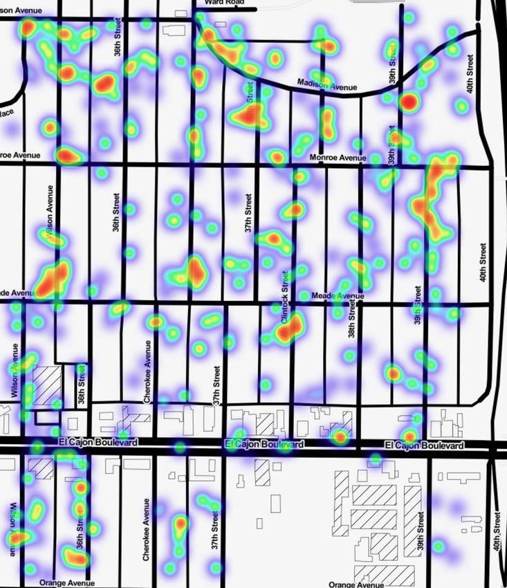
2
1    Introduction
The Red Palm Weevil (also known as Rhynchophorus Ferrugineus, and Rhyn-
chophorus Vulneratus) is a type of beetle that attacks palm trees and that has
become an existential threat for palm trees around the world. The mechanism
of infection involves the beetles laying eggs inside palm trees, with the even-
tual larvae feeding on the palm’s tissue, thus creating tunnels inside the tree
trunk that weaken its structure, finally causing extensive damage that results
in decline and even breakage of the tree (see Figure 1).
     Importantly, the spread of beetles from one palm to another is estimated
up to 50 km per day [1], thus rapidly spreading geographically and raising
tremendous risks to spatially widespread tree locations. In fact, the Red Palm
Weevil has originated from tropical Asia areas [2], yet in the past decades, has
evolved from being only a local problem into a worldwide concern. In 2010,
the Red Palm Weevil reached the U.S [3], which in the following year was also
invaded by its close relative species- the South American Palm Weevil [4]. In
2011, it was already detected in eight European countries, and it has spread
further in the past decade [5]. Today, according to the EPPO (European and
Mediterranean Plant Protection Organization) data sheet, the Red Palm Weevil
has spread to 85 different countries and regions worldwide [6]. Without constant
monitoring, the Red Palm Weevil will keep spreading even further.
     The financial implications of the extensive damage to palm trees are enor-
mous, particularly to date and coconut growers. In fact, the Food and Agricul-
ture Organization of the United Nations estimates that in 2023, the combined
cost of pest management and replacement of damaged palm trees, in Spain and
Italy alone, will reach 200 million Euro [7]. Moreover, the threat from the Red
Palm Weevil occurs to be not just financial, but also of injury to matter and
individuals. In many countries around the world, palm trees are considered
decorative trees planted in residential neighborhoods, and an infested tree has a
higher likelihood of breaking down under strong winds, thus endangering human
lives. For example, in Israel, the Ministry of Agriculture has officially stated
that it is just a matter of time until someone would be seriously injured from a
collapsing infected palm [8].
     Importantly, early detection of palm tree infestation may save trees from irre-
versible damage [9]. At those earlier stages, control methods could be used, most
commonly by the application of insecticides [9]. Thus, to eradicate the pests
efficiently, an accurate mapping of infestation hot-zones is highly advisable, es-
pecially of privately planted palm trees, whose locations are not documented
officially. In the past couple of decades, various Red Palm Weevil detection
methods were proposed.
     There have been large efforts based on acoustic detection [10, 11, 12, 13, 14,
15] as well as methods utilizing canines [16, 17]. However, these methods do
not deal with the mapping of tree locations. Moreover, most of these attempts
fall from being applicable at a large scale as well as in urban areas, where many
homeowners are unaware of the danger and do not realize infestation until it is
too late for treatment [18].

                                         3
Figure 1: Deganya Alef, Israel. A Red Palm Weevil infested date plantation.
Left side: infested trees that needed to be taken down. Right side: trees still
intact. Image taken by Omer Tsur - AirWorks aerial photography.

    In this paper, we present a novel method for large scale mapping and de-
tection of Red Palm Weevil infested palms using state-of-the-art deep learning
algorithms. We believe our proposed large scale approach may be of highly
financial importance to countries around the world, reduce risks of injury at
urban areas, and massively save agriculture fields.
    Our algorithm is based on the following steps: First, we collect and label
aerial and street-level images of palm trees. We then train three deep-learning
models for palm detection on aerial images, palm detection from street-level
images, and finally an infested palm classifier on the detected images. Next,
we utilize the trained aerial palm detection model to identify palm trees down-
loaded from Google Maps aerial data and map the identified palm tree locations
into spatial coordinates. For each detected tree we retrieve the nearest street
view panorama from Google Street View and compute the camera heading that
centers on the palm tree detected in the aerial images. These tree centered
images are used for the detection of palms by our street-level palm detection
model. Finally, we apply a novel infested palm tree classifier to uncover infested
Red Palm Weevil palm trees and highlight hotspots of palm trees, with a high
probability of tree infestation.
    We analyzed more than 100,000 images mapping palm trees utilizing both
aerial and street-level imagery. We demonstrate that a combination of aerial
and street-level imagery produces a cost efficient method for mapping specific

                                        4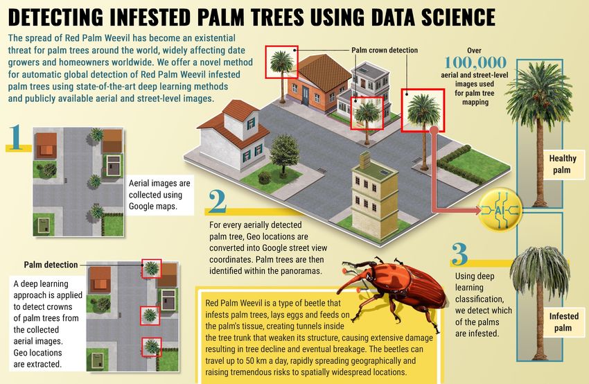
objects. We apply deep-learning based image processing algorithms to demon-
strate that it is possible to identify infested palm trees based on low quality
street view images. Additionally, we show that in many cases it possible to
monitor the progress of the infestation. We demonstrate that there is an oppor-
tunity to revolutionize Red Palm Weevil management using computer vision.
    The multiple key contributions of this study are the following:
    • A novel framework (see Section 3) that utilizes deep learning and imagery
      data to automatically detect Red Palm Weevil infested palm trees quickly
      over large geographic areas.
    • An approach for palm tree mapping in urban areas using aerial or street-
      level images that allows municipalities to efficiently (quickly at low cost)
      perform preventive chemical treatments. We demonstrate that we can
      monitor palm tree degradation and inspect changes in the status of infes-
      tation over time.
    • The presented approach can be utilized to identify regions in which there
      is a higher probability for infestation, and as a result, should be surveilled
      more carefully.
    The remainder of the paper is organized as follows: In Section 2, we present
an overview of related studies. In Section 3, we describe the datasets, meth-
ods, algorithms, and experiments used throughout this study. In Section 4,
we present our results. In Section 5, we discuss the obtained results. In Sec-
tion 6, we present the research limitations. Lastly, in Section 7, we present our
conclusions from this study.

2     Related Work
In this study, we offer a novel framework to automatically detect Red Palm
Weevil infested palm trees on large scale geographic areas, that is also appli-
cable for urban regions. Both these points are currently not supported using
existing methodologies. We therefore cover here work related to both these
novel points offered in the current manuscript, namely- large scale detection
and urban mapping.

2.1    Large Scale Detection of Red Palm Weevil Infestation
As noted in the Introduction, early detection of palm tree infestation is critical
in order to allow treatment that may save trees from irreversible damage. There
are various methods for Red Palm Weevil infestation detection, all of which are
geographically limited by scale [19]. The most straightforward method is by
visually inspecting tree by tree. However, this type of method is naturally not
feasible on a large scale [19]. To overcome this limitation, other methods were
proposed. One such possibility that was raised was of using trained animals for
odor-based detection. Specifically, research indicated that insects emit chemicals

                                         5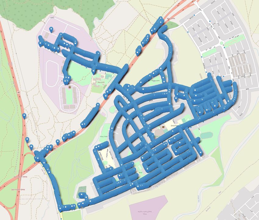
into the air [20] and that dogs could be successfully used for detecting Weevil
infested palm trees [16, 17]. However, this approach too, could not be applicable
at large scales Soroker et al. [19]. Another approach that was raised is sound-
based detection, relying on the fact that the Red Palm Weevil larvae produce
sounds while feeding through the palm tree. Multiple such frameworks were
suggested over the years [10, 11, 12, 13, 14, 15]. There is no doubt that the
acoustic method is feasible, yet it too requires approaching each tree individually
[19], thus limiting its scale of performance. There are indications that in some
conditions, yet another detection approach, based on thermal imaging could
be used to detect infested palm trees [19, 21]. However, at its current state
it is only suitable for detection of infestations in open areas and its detection
accuracy is lower than detection by either dogs or acoustic based approaches
[22]. In summary, monitoring palms at a large scale is considered a challenging
and presumably costly task, especially in urban areas where there is a large
variance in age, spices, growth, and condition of vegetation [19, 23].

2.2     Mapping Objects in Urban Environments Based on
       Street View Images
Google street view has been used in multiple applications for urban street map-
ping, with applications to a variety of domains. Below is a brief introduction
to several such sample studies. In 2015, Balali et al. [24] created an inven-
tory of street signs using imagery data collected from Google Street View. To
detect and classify the collected dataset of signs, they used HOG (Histogram
of Oriented Gradients) along with color, using a linear (SVM) classifier. In
a follow-up study, Campbell et al. [25] used deep learning for mapping street
signs in a sample city (The City of Greater Geelong), demonstrating that the
model can automatically learn to detect two different types of street signs (Stop
and Give Way signs). In 2017, Gebru et al. [26] used 50 million Google Street
View images to estimate the socioeconomic status of 200 US cities. They used
deep learning to detect the make, model, and year of vehicles in each area. The
data analysis revealed an interesting correlation between car information and
demographic data, including voter preferences, ethnicity, etc. The same year,
Seiferling et al. [27] used Google street view to quantify tree coverage in urban
areas. To estimate tree coverage, they used a multi-step image segmentation
model on the collected data. Along those lines, in 2018, Branson et al. [28]
presented a method for mapping the actual tree species using street imagery.
They combined both street and aerial imagery to train a CNN (Convolutional
Neural Network)-based classifier to classify tree images into 140 different tree
species. Their important work emphasizes the vast potential of using advanced
technologies on online data sources in order to map and classify vegetation in
urban areas. In another interesting study of urban mapping, published in 2019,
Helbich et al. [29] used Google Street View, satellite imagery, and deep learning
to map green (vegetation) and blue (waterscapes) spaces in Beijing in order to
explore correlations between green and blue spaces to mental health among the
elder population. Law et al. [30] used street view and satellite imagery, and

                                        6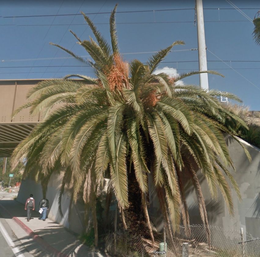
deep learning to extract visual features from satellite and street view images, in
order to estimate housed prices. Their research was driven by the assumption
that house prices are affected by the neighborhood amenities and other features
that can be quantified using images.
   These and other studies demonstrate the tremendous potential of urban
mapping for an amazingly wide range of applications, including those of tree
mapping, as the one offered in our study.

3     Methods and Experiments
3.1    The Proposed Method and Training of the Models
In this study, we strive to demonstrate the
potential of automatically detecting Red
Palm Weevil and South American Palm
Weevil infested palm trees at large scales
using computer vision algorithms. The
rationale is to provide a basic 2-step ap-
proach in order to map all palm trees in
a given area, using a tree detection model
and a subsequent classifier to identify in-
fested trees amongst them. Such an ap-
proach would be most suitable for small
cities or cities highly populated with palm
trees. However, it would be inefficient for
large cities, or cities with relatively low
densities of palms. In fact, since collect-
ing and processing images may carry con-
siderable costs in terms of both money
and time, the efficiency of the palm-tree
detection method in use is utterly impor-
tant.
    Thus, to improve efficiency of the pro-
posed method, we added an additional
pre-processing step prior to palm tree de-
tection from street-level images. In this
                                             Figure 2: Infested palms detection
pre-processing step, we first detect palm
                                             process.
trees from aerial images and only then
proceed to detection from street level, the
advantage being that while street-level imagery can be used for object detection
in a radius of several meters, a single aerial image can be used for preliminary
detection of objects in much broader areas. This allows an efficient large scale
scanning of areas, taking advantage of the trees being large enough objects to be
detected from satellite images [28]. Importantly, aerial detection provides pre-
cise coordinates that can later be used for flagging towards treatment actions.

                                        7
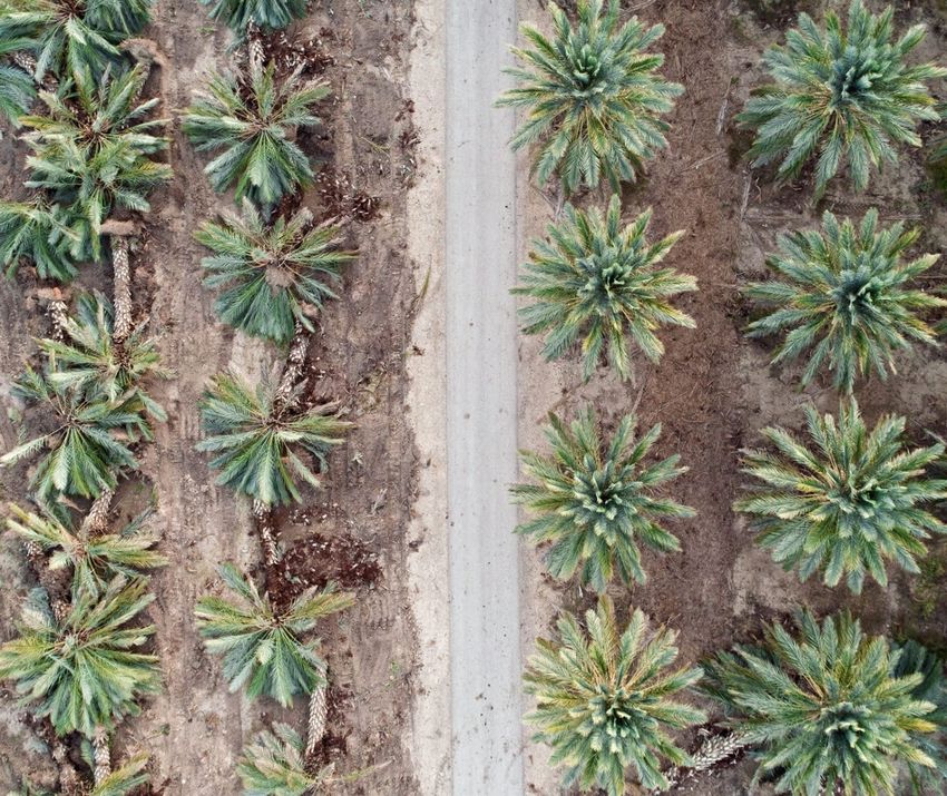
(a) An aerial image.       (b) Palm detection in an       (c) Calculating palm
                                     aerial image.                coordinates.

   (d) Calculating angles      (e) Retrieving the street      (f) Palm tree crown
   between the streetview     view image nearest to the            detection.
    image and the palm.               palm tree.

Figure 3: Palm tree detection process step by step.

This is in contrast to Street View imagery, which provides coordinates of the
camera in use, along with the camera heading, but not the actual coordinates
of the detected object.
    The proposed method is thus composed of the following steps:
   1. Palm Tree Detection from Aerial Imagery

         • Data Collection. To train a palm tree detection model we collected
           a set of 257 aerial images containing palm trees. We focused on
           images collected from Miami area in FL (US), an area known to have
           high densities [31] and rich varieties of palm trees [32]. The images
           were collected from the Miami Dade county imagery.
         • Creating a Training Set. We created a training set by manually
           labeling 257 images containing a total of 1,028 palm trees.
         • Training an Aerial Palm Tree Detection Model. We used the
           PyTorch1 library to apply transfer learning on a pre-trained Convo-
           lutional Neural Network (CNN). In order to achieve a better gener-
           alization of the model in use, we increased the variance of the data
           by data augmentations in multiple dimensions.2 The model was pre-
  1 https://pytorch.org/
   2 The following parameters were augmented randomly: hue, saturation, brightness, con-

trast, RGB shifting, vertical flip, horizontal flip, gaussian blur, rotation.

                                           8
trained on the COCO dataset, the standard training dataset used by
            PyTorch for object detection and segmentation problems. From the
            object detection pre-trained models provided by PyTorch, we chose
            to use Faster R-CNN ResNet-50 FPN [33], which is an improved
            version of the model that achieves higher Average Recall (AR) and
            Average Precision (AP) without sacrificing speed, or memory and
            offers the fastest performance in terms of training and inference time
            [34]. Training and inference time is critical since we use a single RTX
            2080 GPU on over 100,000 images. The model was evaluated using
            the Mean Average Precision3 (mAP) metric on a 20% validation set.
       • Extracting Coordinates of Tree Object Locations. Using the
         trained aerial detection model, we detected trees over wide urban
         areas (see Figure 3b). To convert the output of the detection model
         from (x,y) coordinates, corresponding to image pixels, into actual
         physical locations, we performed the following: First, since input
         images are given in the format of tiles, and tile border coordinates per
         image are known, we mapped tile coordinates from Google coordinate
         format (EPSG:3857) onto WSG 84 coordinate system and calculated
         the bounds of the tile. We then performed affine transformation to
         convert the detected palm trees bounding box boundaries onto WGS
         84 coordinates. Finally, we calculated the center of the bounding box
         to represent the coordinates of a palm tree location (see Figure 3c).

2. Palm Tree Detection from Street View Images in Urban Envi-
   ronments:
    We trained an object detection model to detect palm trees from the col-
    lected street-level images.

       • Data Collection. To train a street view palm detection model we
         first collected a set of 314 Street View images of palm trees. Im-
         ages were collected using Google Street View, each image size was
         640x640. In accordance with the collected data for the aerial detec-
         tion model, we focused on images collected from the same region of
         Miami-Dada county, FL.
       • Training the Street View Palm Detection Model. We per-
         formed manual labeling of palms on the collected dataset, by drawing
         bounding boxes over palm tree crowns while minimizing background
         as much as possible. A total of 314 images, containing 888 palm
         trees, was used for training the model. Similarly to the aerial de-
         tection model, also here, we applied transfer learning using Faster
         R-CNN ResNet-50 FPN [33] pre-trained on COCO as our model,
         with the PyTorch4 library. Data augmentations were also performed
3 Pascal   VOC metric
4 https://pytorch.org/

                                         9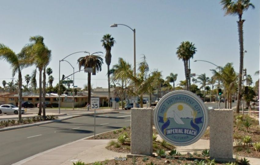
as for training the aerial detection model. The model was evaluated
           using the mAP metric on a 20% validation set.
         • Localizing Palm Trees for Classification. To determine the
           physical location of the palm tree for subsequent classification, for
           each palm tree detected in the aerial images, we extracted the near-
           est coordinates of a street view panorama. Next, we calculate the re-
           quired heading of the camera using the following equation (see Figure
           3d):
                       f ov = atan2(xpano − xaerial , ypano − yaerial )
           Using the calculated f ov for each palm tree we retrieved the cor-
           responding street view image (see Figure 3e). We then applied the
           palm tree crown detector to identify all the palm trees in the image
           (see Figure 3).

   For each palm tree crown detected by the trained street-level palm crown
   detector, we proceed to predict whether it is healthy or infested.

3. Classification of Detected Palm Trees into Healthy/Infested:
   To train a model for identifying whether detected palm trees are healthy or
   infected, we used 70 images containing infested palm tree crowns. We used
   only the palm crowns for classification, the logic being that since the res-
   olution of palm crowns is relatively low in Street View images (less than
   640x6405 ) it should be easier to detect infestation symptoms in crowns
   than in the tree trunk in low resolution images. We used the same im-
   ages that were manually labeled for training the palm crown detection
   model. During the process of data, we realized that the Palm Beach data
   did not have samples of Date Palms. Thus, to add Date Palms to the
   data, we labeled additional 224 healthy palm trees from the rich in palms
   neighborhood in Omer, Israel, and 53 healthy palm trees from Los Angels,
   US.
   We used transfer learning on the XResNet model pre-trained on ImageNet,
   with the fastai [35] library. XResNet is an improved ResNet architecture
   developed by fastai and based on the work of He et al. [36]. XResNet
   features three tweaks (ResNet-B, C, and D) which He et al. [36] demon-
   strated to improve model accuracy consistently. We used fastai standard
   augmentations and progressive resizing [37] for training the model.
   To train the classifier, we integrated out-of-domain data, namely images
   not containing palm trees. Since a classifier will always return a class
   with the highest value as classification we included an unknown class to
   contain such out-of-domain data samples. In fact, Zhang and LeCun [38]
   has shown that such an approach has an extra regularization effect with
   supervised learning. To get a variable sample of out-domain-data we used
   the Caltech 101 dataset [39]. This dataset contains 101 different categories
5 The   max size of a Street View image

                                          10
to be used for the “unknown” class. We also added object data samples
collected from street view images, including non-palm trees, billboards,
cars, etc. To deal with data imbalance, the infested palm trees were
over-sampled (from 70 to 892) and the Caltech 101 classes were under-
sampled uniformly 8 images of each class. We tested the model on palm
trees that we manually identified as infested and on images of the same
palms prior to infestation. To manually identify infested palm trees we
relied on the Food and Agriculture Organization (FAO) guidelines [9].
According to the guidelines, infested palm trees should have symptoms
such as oozing of a brown, viscous liquid from the site of infestation,
boreholes, large cavities, and even the crown can fall off. Different palm
trees have different symptoms. Phoenix canariensis specifically and some
types of date palms should have symptoms that are more visible in the
crown. For example, they would have holes in the fronds, absence of new
fronds, wilting/dying of already developed fronds, and/or an asymmetrical
crown. Also, sometimes leaves above the older leaf whorls are dry. Limited
by the image resolutions of Google Street View, we focused on detecting
symptoms that are manifested in the palm tree crown.
3.2 Curating an Image Datasets
We curated data for three different tasks:
1. Palm tree detection from aerial imagery: To collect aerial imagery data
we used Google Maps. The tiles (images) were collected for a specific
geographic area at zoom 20. The image size was 256x256 pixels.
2. Palm tree detection from street-level: To collect street-level data we used
Google Street View. Each image has a heading of 90 degrees. The image
size was 640x640 pixels.
3. Infested palm tree classification: To collect healthy and infested palm
tree images we manually collected images for both classes. Infested palm
tree images were collected from various websites utilizing Google Search.
Images that represent healthy palm trees were selected manually using
images downloaded from Google Street View.
3.3 Evaluating the Method on Test Data
For demonstrating the potential of our proposed method, we focus on two phys-
ical locations reported of having infested palm trees. For evaluation of the
method, we choose to focus on the San Diego area since according to a report
by Hodel et al. [40] in 2016, an infestation was found in the San Ysidro area of
San Diego, and since there are also street view images from the referred period.
As another case study for palm tree mapping we chose the small town of Omer,
Israel, which contains a high density of palms. Because of its small size and
11its high density of palm trees, it is a perfect use-case for demonstrating tree
mapping from street-level images.
To test performance of our palm mapping methodology, we evaluated three
sub scenarios- aerial mapping, street-level mapping, and combined method.
To test performance of our infested palm trees detection classifier in urban
areas, in real-world conditions, we collected street image data from the San
Ysidro, Imperial Beach, Old Town, Petco Park areas. The images for San
Ysidro were collected between February 2015 and April 2016, a time period
prior to the date specified in the report [40]. For the other areas, the images
were collected from 2018 according to the timestamp on the presented images
in the website [41]. We used the street layer supplied by an open street map to
extract coordinates that represent the streets. The coordinates were extracted
with a distance of eight meters between each following point. For each point,
we collected the nearest panorama from which we extracted four images in the
fields of views of 0, 90, 180, and 270. We then used our palm tree classifier to
extract all the palm crowns from the collected street view images and finally
classified the crowns to either healthy or infested. To evaluate performance,
we searched for the trees presented in the reports [40, 41] as well as additional
potentially infected trees.
To blindly find newly infested trees for which we had no prior reports (see
Figure 2), we used our full method as presented in the Methods section, by
initially detecting the palm trees using aerial imagery, then applying detection
and classification on Street View images. Since the search space is enormous,
as a proof of concept, we focused on the San Diego area, specifically on neigh-
borhoods where infested trees were found in the past. The usage of aerial
images reduces the search space saving time and money. We also inspected
additional neighborhoods where residents mention Red Palm Weevil on social
media. These raised only recent street view photos from 2019 and 2020 from
which we retrieved the newest photos for each location.
To measure the effectiveness of using aerial imagery for reduction of the
search face we performed a comparison of both methods. We calculated the
required number of street view images to fully, map a specific area. Next, we
used the full method on the same area and calculated the number of aerial and
street view images the was required to map the same area.
Finally, we also explored the temporal propagation of palm tree infestation,
in search of the point in time in which a palm tree was infested. We chose the
palm trees that were classified as infested and retrieved their history street view
images. Since each image may contain multiple trees and repeated street view
images are not necessarily taken at the exact same coordinates, we employed the
following heuristics to re-center the trees. First, we calculate the point of view
using the newer street-view coordinates and the aerial coordinates using atan2.
If the newer street viewpoint is farther from the aerial retrieved coordinates than
the original street view image we retrieve the image using the calculated point
of view. Otherwise, we calculate the shift of the palm in the image (90∗((xlef t +
xright )/2)/640 − 45) and it to the calculated heading. Next, we classified the
palm tree past images to detect at which times it was already infested.
124 Results
Figure 4: Streetview panoramas locations in which palm trees where detected.
To detect and map Weevil infested palm trees (see Section 3), we collected
over 100,000 aerial and Street View images that were online available on the
Google Maps platform. Out of the downloaded dataset, we extracted a total
of 47,138 aerial 61,009 street-level images of palm trees. Using our proposed
methodology, we identified at least 40 palm trees suspected of infestation.
In terms of palm tree detection from downloaded images, the palm tree aerial
detector achieved a performance of 0.50 mAP and the street-level palm detector
achieved mAP of 0.90. The palm tree health classifier achieved an F1 score of
0.84, precision of 0.83, recall of 0.85, and AUC of 0.948.
To evaluate the potential of palm tree mapping from street view images
we chose a small town highly populated with palms as a use case, in order to
demonstrate the strength of the proposed method in identifying infested palms,
specifically in urban environments. We download 3,209 panorama images from
Google Street View of the small town of Omer, Israel. We were highly successful
in identifying palm trees in 2,609 out of the 3,209 panoramas (see Figure 4),
even in this urban setting.
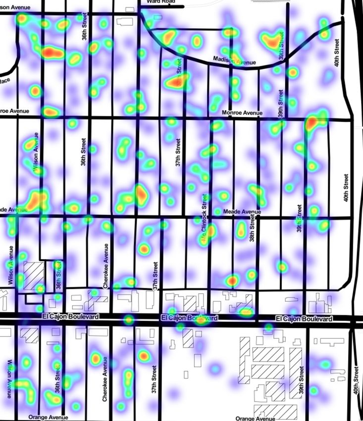
13Next, we demonstrate that by using aerial images we reduce the number
of required street view images needed for mapping palm trees in urban areas,
significantly reducing our search space. For example, to map palms in a sample
neighborhood, namely the Normal Heights Village, San Diego we used 546 aerial
images. In these 546 aerial images, we detected 756 palm trees. To map all
Normal Heights Village areas using Street View only 1,136 panorama images
are required, where each panorama is essentially composed of four images (the
API only returns a 90-degree point of view each time). Thus the search space is
reduced in this example from 1136*4 street view images to 546 street view and
756 aerial images, In Figure 5 we show the comparison of palm tree detection
using aerial images only (see Figure 5a) to palm tree detection using Street View
after aerial detection (see Figure 5b) It can be seen the palm tree detection
results are highly similar in both cases (72% of palm trees detected using aerial
images were confirmed as actual palm trees on street-level imagery), despite the
pre-processing step of search space reduction by aerial imagery.
(a) An aerial palm detection heat map. (b) A street view palm detection heat
map.
Figure 5: Street vs aerial detection heat map presented using Normal Heights
Village, San Diego, CA
As a proof of concept, we also demonstrate that we can use our proposed
methodology to find actual infested trees in urban areas, using street view im-
agery. Specifically, out of the four infested palm trees described by Hodel et al.
[40] we able to find the exact physical location of three of them (See Figure
6). The location of the fourth tree was described with a general location de-
scription instead of an address, so could not be confirmed. Hodel et al. [40]
reported infested palm trees are dated to March 2016. The nearest images by
date in Google street view were dated for two trees to February 2016 and the
14third three were dated to November 2015. Additionally, we found all three palm
trees that had specified location in an online report [41] (see Figure 8). Our
classifier classified five of the six trees as infested. Additionally, out of 5,008
detected palms, in the same area, the classifier detected additional 13 infested
palm trees, of which we identified eight at advanced infestation stages.
(a) 2281 Fantasy Lane, (b) 2464 E Beyer Blvd (c) 241 W. Park Ave.,
San Diego, California San Diego, California San Diego (November,
(February ,2016) (February ,2016) 2015)
Figure 6: Google street view images of the infested palm trees presented by
Hodel et al. [40].
(a) 225 Park Blvd San (b) 7th St Imperial (c) 2572 Congress Street,
Diego, California (April Beach, California San Diego, CA, USA
,2018) (January ,2018) (February, 2020)
Figure 7: Google Street View images of the infested palm trees presented by
Aguilar Plant Care [41]
We also wanted to demonstrate the potentially efficiently finding newly in-
fested trees using aerial and street-level imagery combined. We retrieved 22,438
aerial images that lead us to 54,781 street view images. From these images, we
found 36,001 palm trees from which 109 were classified as infested from which
we identified 24 as an infestation at an advanced stage. Additionally, we demon-
strate that our method can be utilized to find the time interval during which
the palm tree was infested. Observing Figure 9 we see that according to our
classifier in November 2017 (see Figure 9a) the palm tree still was not infested.
However, in April 2018 (see Figure 9b) we identified infestation.
15(a) 4452 Taylor St San Diego, (b) 4452 Taylor St San Diego,
California (May ,2019) California (February ,2020)
(c) 2572 Congress St San Diego, (d) 2572 Congress St San Diego,
California (April ,2019) California (February ,2020)
(e) 2505 Congress St San Diego, (f) 2505 Congress St San Diego,
California (April ,2019) California (February ,2020)
Figure 8: Examples of detected infested palm trees, in different stages of the
infestation displayed by Google Street View Images.
16(a) 225 Park Blvd San Diego, California (b) 225 Park Blvd San Diego, California
(November ,2017) (April ,2018)
Figure 9: Identified infested palm tree and the its latest images that identified
as not infested.
5 Discussion
We propose a novel framework for large scale mapping and detection of Red
Palm Weevil infested palm trees, using state-of-the-art deep learning algorithms.
This large scale methodology may be of tremendous financial importance to
countries around the world, help in massively saving agricultural fields, and
assist in reducing risks of injuries in urban areas. The proposed methodology
relies on aerial and street view images available online.
First, we demonstrated how easily can Google Street View images can be
used to map palm trees in small cities. In a small town (Omer, Israel) chosen
as a suitable use-case, we were able to detect thousands of palms. We detected
thousands of palm trees from Omer, Israel street view images. We found that in
almost on every street in Omer there is a Palm tree, making this town extremely
vulnerable to Red Palm Weevil infestation. Nevertheless, we noted that not all
streets of Omer are mapped by Google. We propose that small towns, such
as Omer, may choose to independent annual photoshoot the streets of their
municipality, subsequently applying the offered methodology to the newest data
to detect newly infested trees and perform preventive pestification to save trees.
Additionally, by performing more frequent mapping they can detect an active
infestation and monitor its state.
Second, we show how we could reduce at least six-fold the number of street
17view images required for mapping in urban areas, by initially using rough aerial
palm tree detection. This translates into saving both money (using each street
view image costs 0.007$) and time in data collection and processing. When
mapping large areas using aerial images may save thousands of dollars. Our
results indicate that the majority (72%) of aerial detected palm trees are of
actual palm trees. This number is likely even higher since some palms are
not viewable from the street. Naturally, there are also false positives. In other
words, in most cases, there is no need to use all the area street images. Full street
mapping is only practical in small cities or when the municipality independently
maps the streets, otherwise, the costs using street view could be very high6 .
Third, we illustrated that our method in general and palm tree health clas-
sifier, in particular, can successfully detect infested palm trees. As a sample
case, we detected two out three infected palm trees described by Hodel et al.
[40]. The third reported tree showed only early stages of infestation on March
17, 2016, while the closest street view images dated November 2015. This may
explain why it was not detected by the classifier as being infested, likely because
it was not yet exhibiting visual signs of infestation. The results indicated that
deep learning can be used for detecting infested palm trees. At the current
status of the proposed model, it is able to detect severe and medium infec-
tions. Future studies may focus on modifying the algorithms to detect various
stages of infestation. With more available data for training, as well as access
to images of higher resolution, it may be possible to improve the accuracy of
detection. By using high-resolution trunk images it may possible to also detect
early infestation signs in a variety of palm tree spices.
Fourth, we detected infested palm trees that were not presented in online re-
ports, including areas that were not mentioned in any report. Our results clearly
show the potential of the method to monitor palm tree infestation worldwide
utilizing minimal resources based only on online available data. Urban mapping
of palm trees may slow down the spread of infestation and flag areas for pesti-
fication. Moreover, theoretically- putting costs aside, it is possible to study the
spread of the Red Palm Weevil over both time and space areas creating a map
of their spreads. Such data may be used to predict the path of the spread in a
future infestation.
6 Research Limitations
It is worth noting that the methods used in this study are prone to several
limitations: First, Google aerial images are not taken at the same time that of
street view images, a fact that may lead to missing newly planted palm trees
or detection of palm trees that were already cut down. This of course can be
solved by obtaining aerial images from multiple time points. However, currently,
Google API does not support retrieving older aerial images nor the timestamp
6 We estimate that fully mapping of San Diego area using only street view images should
cost around 51,000$ at the base pricing. The price probably would be lower, Google offers
different pricing for large volumes but it is not specified in the documenting.
18of the current images. Second, occasionally the detected palm tree in aerial
images does not have a line of sight from the street, thus we will not be able
to acquire its street image. Nevertheless, we will at least know it is there, in
contrast to using Street View images only. Third, a single street view image
may contain multiple palm trees, thus often it is hard to determine whether
the same tree is detected by an aerial versus a street view palm tree detector.
Forth, street view images are not taken at constant time intervals, and only
at sporadic time points. This can lead to missing information in some areas at
certain times. Fifth, the number of images of infested palm trees available online
is limited. Moreover, most of those images are of palms at advanced infestation
stages. This limits the performance of the infestation classifier both in terms of
accuracy, as well as on different stages of infestation. Training the classifier on
more data with infested trees on different stages should provide better results.
Sixth, there are many types of palm trees and the symptoms of an infestation
can be different. Currently, most of the photos we found of infested palm trees
are of Cannery Palm trees. With additional data, a specific classifier can be
created for each type of palm tree.
7 Conclusions
Red Palm Weevil has spread across the world damaging and destroying countless
palm trees and date crops. In this study, we developed a novel automatic
framework for detection and monitoring of Red Palm Weevil infestation by
analyzing over 47,000 aerial and 61,000 street views. We first filter the enormous
search space by detecting palm trees in aerial images; then we further analyze
those aerial detected palms using street level images. We demonstrated that
this information can be utilized in order to map palm trees in urban areas and
to detect and monitor Red Palm Weevil infestation.
We demonstrated that using deep learning algorithms and online available
data provides an automatic and cost-effective solution for monitoring and de-
tection of pest infestations. Such a solution can help ministries of agriculture
and governments worldwide to fight and contain the spread of Red Palm Weevil
in a cost-effective fashion. Our method can be instantly deployed to any scale
of need and every geographic location where street view level imagery is acces-
sible. Standard commonly existing procedures for monitoring infested palms
require specialized equipment, time, cost and effort, thus not very effective for
large scales. In the current state of the Red Palm Weevil spread such a tool is
essential for confronting against the Red Palm Weevil damage.
8 Data availability
The data contains mostly images from Google Maps and Street View, the data
cannot be distributed according to Google terms of service. However, the images
can be accessed using Google API.
199 Acknowledgements
We thank Valfredo Macedo Veiga Junior (Valf) for designing the infographic
illustration and Omer Tsur - AirWorks aerial photography for providing the
Deganya Alef aerial photo.
References
[1] MS Hoddle, CD Hoddle, JR Faleiro, HAF El-Shafie, DR Jeske, and AA Sal-
lam. How far can the red palm weevil (coleoptera: Curculionidae) fly?:
computerized flight mill studies with field-captured weevils. Journal of
Economic Entomology, 108(6):2599–2609, 2015.
[2] Uri Gerson and Shalom Applebaum. Rhynchophorus ferrugineus. http:
//www.agri.huji.ac.il/mepests/pest/Rhynchophorus_ferrugineus/.
(Accessed on 10/17/2020).
[3] Latest pest reports - international plant protection conven-
tion. https://www.ippc.int/en/countries/united-states-of-
america/pestreports/2010/11/first-us-detection-of-the-red-
palm-weevil-rhynchophorus-ferrugineus-in-california/. (Accessed
on 01/19/2021).
[4] Rebecca Bech. Detection of south american palm weevil (rhynchopho-
rus palmarum) in california. https://cisr.ucr.edu/sites/g/files/
rcwecm2631/files/2019-07/USDA-Detection-in-CA-SPRO-DA-2011-
45-SAPW.pdf, 8 2011. (Accessed on 01/14/2021).
[5] The insect killing our palm trees. https://ec.europa.eu/food/sites/
food/files/plant/docs/ph_biosec_red_palm_weevil_brochure_en.
pdf, 10 2011. (Accessed on 10/17/2020).
[6] Eppo datasheets on pests recommended for regulation. https://gd.eppo.
int, 2021. (Accessed on 01/19/2021).
[7] Red palm weevil — food chain crisis — food and agriculture organiza-
tion of the united nations. http://www.fao.org/food-chain-crisis/
how-we-work/plant-protection/red-palm-weevil/en/. (Accessed on
10/16/2020).
[8] The ministry of agriculture cautions there are cities in israel
in which at any minute trees may fall on passers. https:
//www.moag.gov.il/en/Ministrys%20Units/Spokesmanship%20and%
20Publicity%20Department/publications/Pages/dekel_en.aspx, 5
2013. (Accessed on 10/17/2020).
[9] FAO. Red Palm Weevil: Guidelines on management practices. FAO, 2020.
doi: 10.4060/ca7703en. URL https://doi.org/10.4060/ca7703en.
20[10] KAP Siriwardena, LCP Fernando, N Nanayakkara, KFG Perera, ADNT
Kumara, and T Nanayakkara. Portable acoustic device for detection of co-
conut palms infested by rynchophorus ferrugineus (coleoptera: Curculion-
idae). Crop Protection, 29(1):25–29, 2010.
[11] Miguel Martı́nez Rach, Héctor Migallón Gomis, Otoniel López Granado,
Manuel Perez Malumbres, Antonio Martı́ Campoy, and Juan José Serrano
Martı́n. On the design of a bioacoustic sensor for the early detection of the
red palm weevil. Sensors, 13(2):1706–1729, 2013.
[12] Richard W Mankin. Recent developments in the use of acoustic sensors
and signal processing tools to target early infestations of red palm weevil
in agricultural environments. Florida Entomologist, pages 761–765, 2011.
[13] RW Mankin, HY Al-Ayedh, Y Aldryhim, and B Rohde. Acoustic detection
of rhynchophorus ferrugineus (coleoptera: Dryophthoridae) and oryctes el-
egans (coleoptera: Scarabaeidae) in phoenix dactylifera (arecales: Areca-
cae) trees and offshoots in saudi arabian orchards. Journal of economic
entomology, 109(2):622–628, 2016.
[14] J Pinhas, V Soroker, A Hetzroni, A Mizrach, M Teicher, and J Goldberger.
Automatic acoustic detection of the red palm weevil. computers and elec-
tronics in agriculture, 63(2):131–139, 2008.
[15] Islam Ashry, Yuan Mao, Yousef Al-Fehaid, Abdulmoneim Al-Shawaf, Man-
sour Al-Bagshi, Salman Al-Brahim, Tien Khee Ng, and Boon S Ooi. Early
detection of red palm weevil using distributed optical sensor. Scientific
Reports, 10(1):1–8, 2020.
[16] J Nakash, Y Osem, and M Kehat. A suggestion to use dogs for detecting
red palm weevil (rhynchophorus ferrugineus) infestation in date palms in
israel. Phytoparasitica, 28(2):153–155, 2000.
[17] Pompeo Suma, Alessandra La Pergola, Santi Longo, and Victoria Soroker.
The use of sniffing dogs for the detection of rhynchophorus ferrugineus.
Phytoparasitica, 42(2):269–274, 2014.
[18] Maanvi Singh. Red palm weevils wreak havoc on palm plantations across
the globe : The salt : Npr. https://www.npr.org/sections/thesalt/
2017/06/22/532619019/red-palm-weevils-wreak-havoc-on-palm-
plantations-across-the-globe#, 6 2017. (Accessed on 01/14/2021).
[19] V Soroker, P Suma, A la Pergola, Y Cohen, V Alchanatis, O Golomb,
E Goldshtein, A Hetzroni, L Galazan, D Kontodimas, et al. Early detection
and monitoring of red palm weevil: approaches and challenges. In Colloque
méditerranéen sur les ravageurs des palmiers, Nice, France, 16-18 Janvier
2013. Association Française de Protection des Plantes (AFPP), 2013.
[20] Jon C Allen, Dennis D Kopp, Carlyle C Brewster, and Shelby J Fleischer.
2011: An agricultural odyssey. American Entomologist, 45(2):96–104, 1999.
21[21] O Golomb, V Alchanatis, Y Cohen, N Levin, and V Soroker. Detection of
red palm weevil infected trees using thermal imaging. Precision agriculture,
15, 2015.
[22] Ali Ahmed, Abdelhameed Ibrahim, and Sherif Hussein. Detection of palm
tree pests using thermal imaging: A review. Machine Learning Paradigms:
Theory and Application, pages 253–270, 2019.
[23] Maged EA Mohammed, Hamadttu AF El-Shafie, and Mohammed R Alha-
jhoj. Recent trends in the early detection of the invasive red palm weevil,
rhynchophorus ferrugineus (olivier). In Invasive Species-Introduction Path-
ways, Economic Impact, and Possible Management Options. IntechOpen,
2020.
[24] Vahid Balali, Armin Ashouri Rad, and Mani Golparvar-Fard. Detection,
classification, and mapping of us traffic signs using google street view im-
ages for roadway inventory management. Visualization in Engineering, 3
(1):15, 2015.
[25] Andrew Campbell, Alan Both, and Qian Chayn Sun. Detecting and map-
ping traffic signs from google street view images using deep learning and
gis. Computers, Environment and Urban Systems, 77:101350, 2019.
[26] Timnit Gebru, Jonathan Krause, Yilun Wang, Duyun Chen, Jia Deng,
Erez Lieberman Aiden, and Li Fei-Fei. Using deep learning and google
street view to estimate the demographic makeup of neighborhoods across
the united states. Proceedings of the National Academy of Sciences, 114
(50):13108–13113, 2017.
[27] Ian Seiferling, Nikhil Naik, Carlo Ratti, and Raphäel Proulx. Green streets-
quantifying and mapping urban trees with street-level imagery and com-
puter vision. Landscape and Urban Planning, 165:93–101, 2017.
[28] Steve Branson, Jan Dirk Wegner, David Hall, Nico Lang, Konrad Schindler,
and Pietro Perona. From google maps to a fine-grained catalog of street
trees. ISPRS Journal of Photogrammetry and Remote Sensing, 135:13–30,
2018.
[29] Marco Helbich, Yao Yao, Ye Liu, Jinbao Zhang, Penghua Liu, and Ruoyu
Wang. Using deep learning to examine street view green and blue spaces
and their associations with geriatric depression in beijing, china. Environ-
ment international, 126:107–117, 2019.
[30] Stephen Law, Brooks Paige, and Chris Russell. Take a look around: using
street view and satellite images to estimate house prices. ACM Transactions
on Intelligent Systems and Technology (TIST), 10(5):1–19, 2019.
[31] Density gradient of native palm (arecaceae). http://bonap.org/
2015_SpecialtyMaps/Density%20Gradient%202015/original/2tax22_
Palms.png. (Accessed on 01/30/2021).
22[32] Evan Williams. Our mighty palm trees — palm beach florida weekly.
https://palmbeach.floridaweekly.com/articles/our-mighty-palm-
trees/, 1 2018. (Accessed on 01/18/2021).
[33] Tsung-Yi Lin, Piotr Dollár, Ross Girshick, Kaiming He, Bharath Hariha-
ran, and Serge Belongie. Feature pyramid networks for object detection. In
Proceedings of the IEEE conference on computer vision and pattern recog-
nition, pages 2117–2125, 2017.
[34] torchvision.models — pytorch 1.7.0 documentation. https://pytorch.
org/docs/stable/torchvision/models.html. (Accessed on 01/28/2021).
[35] Jeremy Howard and Sylvain Gugger. Fastai: A layered api for deep learning.
Information, 11(2):108, 2020.
[36] Tong He, Zhi Zhang, Hang Zhang, Zhongyue Zhang, Junyuan Xie, and
Mu Li. Bag of tricks for image classification with convolutional neural
networks. In Proceedings of the IEEE Conference on Computer Vision and
Pattern Recognition, pages 558–567, 2019.
[37] Jeremy Howard and Sylvain Gugger. Deep Learning for Coders with fastai
and PyTorch. O’Reilly Media, 2020.
[38] Xiang Zhang and Yann LeCun. Universum prescription: Regularization
using unlabeled data. In Proceedings of the AAAI Conference on Artificial
Intelligence, volume 31, 2017.
[39] Li Fei-Fei, Rob Fergus, and Pietro Perona. One-shot learning of object
categories. IEEE transactions on pattern analysis and machine intelligence,
28(4):594–611, 2006.
[40] DR Hodel, MA Marika, and LM Ohara. The south american palm weevil:
a new threat to palms in california and the southwest. Palm Arbor, 3:1–27,
2016.
[41] South american palm weevil — aguilar plant care — plant and tree heath
care specialist. https://aguilarplantcare.com/south-american-palm-
weevil/. (Accessed on 03/09/2021).
23You can also read