Avalanche activity and socio-environmental changes leave strong footprints in forested landscapes: a case study in the Vosges medium-high mountain ...
←
→
Page content transcription
If your browser does not render page correctly, please read the page content below
Annals of Glaciology 59(77) 2018 doi: 10.1017/aog.2018.26                                                                                         111
          © The Author(s) 2018. This is an Open Access article, distributed under the terms of the Creative Commons Attribution licence (http://creativecommons.
          org/licenses/by/4.0/), which permits unrestricted re-use, distribution, and reproduction in any medium, provided the original work is properly cited.

           Avalanche activity and socio-environmental changes leave strong
             footprints in forested landscapes: a case study in the Vosges
                             medium-high mountain range
                        Florie GIACONA,1,2 Nicolas ECKERT,2 Robin MAINIERI,3 Brice MARTIN,4
                         Christophe CORONA,5 Jérôme LOPEZ-SAEZ,1 Jean-Matthieu MONNET,3
                                       Mohamed NAAIM,2 Markus STOFFEL1,6,7
                    Institut des Sciences de l’Environnement – Université de Genève, 66 bd Carl Vogt, CH-1205 Genève, Suisse.
                    1

                                                           E-mail: florie.giacona@irstea.fr
                   2
                    University Grenoble Alpes, Irstea, UR ETGR, 2 rue de la Papeterie-BP 76, F-38402 St-Martin-d’Hères, France
                 3
                   University Grenoble Alpes, Irstea, UR LESSEM, 2 rue de la Papeterie-BP 76, F-38402 St-Martin-d’Hères, France
                    4
                      Université de Haute-Alsace, Centre de recherche sur les Économies, les Sociétés, les Arts et les Techniques,
                                                          68093 Mulhouse Cedex, France
                               5
                                 GEOLAB, UMR6042 CNRS/Université Blaise Pascal, Maison des sciences de l’homme,
                                                      63057 Clermont-Ferrand Cedex 2, France
           6
             dendrolab.ch, Department of Earth Sciences, University of Geneva, 13 rue des Maraîchers, CH-1205 Geneva, Switzerland
                 7
                  Department F.A. Forel for Aquatic and Environmental Sciences, University of Geneva, 66 Boulevard Carl-Vogt,
                                                           CH-1205 Geneva, Switzerland

                        ABSTRACT. The medium-high mountain ranges of Western Europe are undergoing rapid socio-environ-
                        mental changes. The aim of this study is to show that their landscape can be strongly shaped by the
                        actions of avalanche activity, humans and climate. The study area is the Rothenbachkopf-Rainkopf
                        complex, a site representative of avalanche-prone areas of the Vosges Mountains (France). A geo-histor-
                        ical approach documents regular avalanche activity over more than 200 years on 13 paths. A diachronic
                        analysis of historical maps and photographs demonstrates substantial afforestation (from 60 to 80% of
                        the total surface since 1832). LIDAR data and field surveys highlight the existence of a longitudinal
                        and transversal structure of trees. Hence, the avalanche, human and climate activity footprints are
                        retained by the landscape, which rapidly adapts to these changing drivers. Specifically, the pattern of
                        tree species and heights results from a near equilibrium with regular avalanche activity sometimes dis-
                        turbed by major avalanches that induce quasi-cyclic changes in the landscape mosaic. The afforestation
                        trend is attributable to profound changes in silvo-pastoral practices, supplemented by the impact of
                        climate change. The wider relevance of the results in relation to the local context is discussed, as well
                        as outlooks that can refine our understanding of this complex system.
                        KEYWORDS: avalanches, climate change, geomorphology

          INTRODUCTION                                                                            the multiple human, climatic and avalanche activity drivers
          In mountain areas, forests are structured by multiple factors.                          that affected the forest stands during their history. These
          Certain of these are internal such as soil type, slope, etc.,                           dynamics are particularly complex, and the visual aspect of
          whereas others exert external pressures: prevailing climatic                            the slopes is highly variable over time.
          conditions, forest logging, etc. The patterns of individual                                In the literature, the concept of medium-high mountains
          trees, forest species and forest stands contribute to the land-                         refers to either an altitudinal stage of high mountain environ-
          scape mosaic on the slopes, which is not stationary over                                ments or a full topographic entity of modest elevation
          time: frequent changes occur in response to changes in                                  (Rieutort, 1997). This paper refers to the second meaning of
          human activities and/or climate. Under favourable condi-                                the term. Medium-high mountain ranges are often contrasted
          tions, snow avalanches or other natural hazards (Benda                                  to high-altitude mountain ranges in terms of altitude, topog-
          and others, 1998; Schumacher and Bugmann, 2006;                                         raphy (old versus young mountains, rounded tops versus
          García-Aguirre and others, 2012) generate disturbances                                  rugged peaks, etc.), natural processes (seasonal snow cover
          which are visible from the level of individual trees to the                             only versus glaciers) or practices (everyday living space
          scale of entire forest stands (Walsh and others, 2004;                                  versus marked seasonal rhythm associated with tourism).
          Simonson and others, 2008; Teich and others, 2012; Feistl                               Their highest elevations are covered by mountainous to sub-
          and others, 2014). As a consequence, avalanche activity                                 alpine vegetation. They remain preserved wilderness areas
          and its variation over time may also contribute to landscape                            but have also been everyday living spaces for centuries,
          genesis (Malanson and Butler, 1986; Walsh and others,                                   and therefore, possess a rich cultural heritage (Sgard,
          1994). Hence, the landscape dynamics of a forest slope sub-                             2007). In France, this corresponds to the Jura, the Massif
          jected to avalanches result from the integration over time of                           Central and the Vosges Mountains whose elevation ranges

Downloaded from https://www.cambridge.org/core. 25 Dec 2021 at 11:50:04, subject to the Cambridge Core terms of use.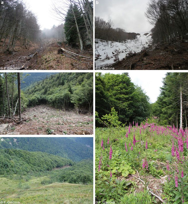
112                              Giacona and others: Avalanche activity and socio-environmental changes leave strong footprints in forested landscapes

              from 600–700 to 2000 m. a.s.l. (Rieutort, 1997). In Europe,                             environment has remained limited so far. Also, much of
              identification of such massifs may be more complex. It is                               this work was done decades ago (Heath, 1960; Schaerer
              clear, for example, for the Swiss Jura or for Sudetenland                               and others, 1973; Burrows and Burrows, 1976; Luckman,
              (Czech Republic), but such identification is sometimes not                              1977; Butler, 1979; Butler and Malanson, 1985; Johnson,
              easy, for example, for the Carpathians. These are the                                   1987; Butler and Walsh, 1990; Walsh and others, 1990,
              eastern termination of the alpine arc, but their topography                             1994). Remote sensing and signal processing tools that can
              and vegetation cover are close to those of medium-high                                  accurately evaluate area-wide statistics to sum up landscape
              mountains, as we have defined them. Also, a large proportion                            patterns were absent at this time. In more recent studies, the
              of the Scandinavian and Russian mountains (Norwegian                                    focus was often on forest stand adaption to avalanches
              fjords, Kola Peninsula, etc.) and the Scottish Highlands are                            (Kulakowski and others, 2006, 2011; Voiculescu and
              very similar to our topographical criteria but are charac-                              Ardelean, 2012), which involved refined analysis of eco-
              terised by alpine vegetation because of a harsher climate                               logical processes at play, but was not conducted at the
              and they are not densely populated. Yet, all in all, medium-                            scale of a whole forest slope due to the amount of refined
              high mountain ranges as we understand them, exist in                                    fieldwork required (e.g. Schönenberger and others, 2005).
              many parts of the world: the northeastern USA, Quebec, nor-                             Alternatively, in different studies, forest landscape patterns
              thern Japan, etc., but it may be fair to say that, apart from                           and their changes at specific dates were obtained as a by-
              exceptions (e.g. Hétu and others, 2015), they have been                                 product of tree-ring reconstructions of past avalanche activity
              overlooked in the scientific literature compared with high                              (e.g., Decaulne and others, 2014; Šilhán and Tichavský,
              mountain ranges (Andes Cordillera, Rocky Mountains,                                     2017; Favillier and others, 2018; Krause and Krížek, 2018).
              European Alps, etc.), especially in terms of studies concern-                           By contrast, studies specifically addressing the secular evolu-
              ing snow and avalanches.                                                                tion of forest landscapes affected by avalanche activity
                  However, in medium-high mountain ranges affected by a                               remain rare (Baker, 1992), and those considering avalanches,
              temperate climate, relations and interactions between                                   human pressure and climate together as potential drivers
              human societies, climate and avalanches are particularly                                nearly absent (Kulakowski and others, 2016).
              strong. Indeed, medium-high mountain ranges are by defin-                                   On this basis, the objective of this paper is to highlight,
              ition at rather low altitudes (
Giacona and others: Avalanche activity and socio-environmental changes leave strong footprints in forested landscapes                             113

          understand that snow avalanches, climate and human influ-                               beginning of the 19th century to the current rapid warming of
          ence all play a role in the landscape genesis. Hence, in                                anthropic origin clearly perceptible since ∼1985. Multiproxy
          what follows we show (i) that the current landscape retains                             region-wide (Pfister, 1992; Glaser and Riemann, 2009) or
          the footprint of the actions of these three factors and (ii) that                       gridded reconstructions (Casty and others, 2007) exist,
          their evolution has been integrated into the rapid and signifi-                         which can be supplemented by a few instrumental series of
          cant changes in the forest mosaic over the past two centuries.                          meteorological observations (Minárová, 2013). This makes
                                                                                                  it possible to quantify the regional trends having prevailed
                                                                                                  in annual temperature and precipitation. Sources mostly
          VOSGES MOUNTAINS AND STUDY AREA                                                         agree that warming over the study period has been irregular,
                                                                                                  but very significant over the study period. The study area has
          Physical context of the Vosges Mountains                                                also evolved towards a slightly wetter climate (Appendix A).
          The Vosges Mountains are located in the north-east of                                       How these major trends in temperature and precipitation
          France; they are ∼150 km long and vary in width from 20                                 have affected snow amounts in the inner Vosges Mountains
          to 60 km (Fig. 1a). The main ridge, oriented north-north-                               remains difficult to evaluate precisely due to a lack of con-
          east/south-south-west is composed of a chain of convex                                  tinuous records throughout the study period. However, the
          peaks culminating at 1300–1400 m a.s.l. It is the first oro-                            few observations and statistical results existing highlight
          graphic barrier encountered by atmospheric flows coming                                 that the characteristics of the snowpack were clearly strongly
          from the Atlantic, and it stands perpendicular to the direction                         impacted. Observations made on the Hautes Chaumes at the
          of prevailing winds. These winds sweep and blow the snow                                heart of the coldest decades of the 19th century (Collomb,
          from the flat and forest-free summits to form cornices (up to                           1848; Grad, 1871) document the persistence of snow
          several meters) and wind slabs at the top of the eastern                                patches throughout the year at that time, which has no
          slopes, which are marked by a sudden slope rupture (Wahl                                longer occurred over the recent decades (Wahl and others,
          and others, 2007). The southern part of the Vosges                                      2009). More systematically, Flageolet (2005) compiled and
          Mountains still has visible marks of the quaternary ice age                             processed available snow records, highlighting marked
          including glacial valleys, glacial cirques, moraine deposits                            drops in the number of snow days, cumulated snowfall and
          and slopes >30° (Flageollet, 2003).                                                     snow-cover duration. He evaluated the decrease at 40–
             Because of their latitude and altitude, the climate of the                           60% over the 1970–2000 period at the lowest measurement
          Vosges Mountains is cold and wet, with precipitation                                    stations in the Vosges Mountains (>600 m a.s.l.), whereas,
          throughout the year (climate Cfb according to the Köppen-                               for the highest stations, the decrease over the same period
          Geiger classification). Average annual rainfall varies                                  was less (e.g. −16% snow days and cumulated snowfall for
          between 900 and over 2000 mm (Drogue and others,                                        the Champ du Feu station, ∼1100 m a.s.l.).
          2006). The coefficient of nivosity is 20, 30 and 60%, at
          700, 1000 and 1350 m a.s.l., respectively, and the average
          annual temperature drops from 9 to 4°C between 350 and                                  Societal context and landscape evolution in the Vosges
          1400 m a.s.l. (Wahl and others, 2009). More than 150 frost                              Mountains
          days are recorded on the summits and snow cover may                                     Harsh conditions, especially during the LIA, did not preclude
          persist, in the form of firn, until early summer in the glacial                         from the establishment of human activities, at least seasonal,
          cirques on the eastern slopes. Due to these climatic condi-                             which has left strong footprints since the Middle Ages (Léser,
          tions, numerous avalanches are recorded every year in the                               1995; Kammerer, 2003; Garnier, 2004). The Vosges
          Vosges Mountains (Giacona and others, 2017a). They                                      Mountains contain resources that have already been devel-
          occur mainly on the steeper eastern slopes and are often                                oped by proto-industrial activities such as sawmills, glass-
          released by the breakage of cornices.                                                   works, mines, forges and the metallurgical industry (Jéhin,
             These climatic characteristics combined with topography                              1993; Garnier, 1998, 2004). Concomitantly, local mountain
          induce a theoretical organisation of vegetation in three                                societies were known for their agro-pastoralism, in which
          stages. The Collinean vegetation zone exists up to 400–                                 livestock held a prominent place as the main source of
          600 m a.s.l. and is mainly dominated by beech and oak.                                  wealth. Mountain farming has two periods: summering in
          The mountainous zone is characterised by mixed stands of                                mountain farms, between the end of May and the end of
          beech and fir, often accompanied by spruce. Above 1000–                                 September, and wintering in the valley during the rest of
          1100 m a.s.l., the subalpine belt is characterised by low-                              the year. All these activities strongly shaped the Vosges
          productivity open forest stands dominated by beeches with                               Mountains landscape over the centuries, particularly
          twisted and gnarled trunks, as well as summit meadows,                                  through the pressure exerted on the wood resource and
          the Hautes Chaumes. From paleo-environmental investiga-                                 because of grazing needs. Hence, at the scale of the entire
          tions (pedoanthracology), Goepp (2007) has postulated that                              Vosges Mountains, demography, prosperity and forest stand
          the Hautes Chaumes were deforested by anthropogenic                                     changes are strongly related. Significant clearings occurred
          actions (fires) already during protohistory and that the                                during the demographic expansion in the 16th century. In
          highest peak of the Vosges Massif (1424 m a.s.l.) is now                                contrast, because of a population decrease linked to war epi-
          below the theoretical tree line. However, since the natural                             sodes, reforestation occurred in the 17th century.
          tree line is far from being stationary depending on climate                             Demographic growth in the 18th century and the renewed
          and because of the very long and complex history of                                     development of the Vosges Mountains led to a peak in defor-
          human activities in the Vosges Mountains (see the section                               estation at the end of the 18th century. The clearing was
          ‘Societal context and landscape evolution in the Vosges                                 related to the needs of mountain dwellers for arable land,
          Mountains’), this is difficult to establish with certainty.                             pastures, handicrafts, timber and firewood (Dion, 1985;
             The climate context of the study period expands from the                             Garnier, 2004). Also, at least until the 19th century, proto-
          last few decades of the Little Ice Age (LIA, Grove, 1988) at the                        industrial settlements were large wood consumers (Jéhin,

Downloaded from https://www.cambridge.org/core. 25 Dec 2021 at 11:50:04, subject to the Cambridge Core terms of use.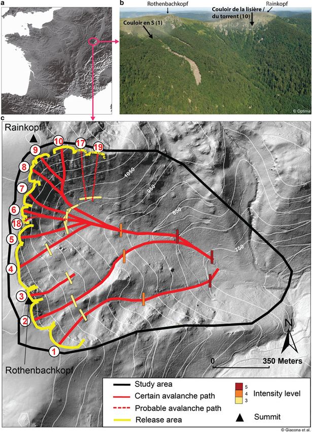
114 Giacona and others: Avalanche activity and socio-environmental changes leave strong footprints in forested landscapes
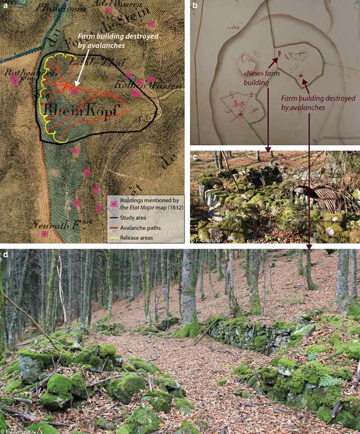
Fig. 1. The Rothenbachkopf-Rainkopf avalanche complex: (a) Location at the French scale, (b) overview of the eastern slopes of the
Rothenbachkopf and Rainkopf summits in June 2014, (c) map of the study area with 1 m resolution LIDAR-based DEM in background.
Correspondence between path names and numbers as well as their topographical characteristics are provided in Table 2. At least one
event could be retrieved in historical sources for each of the ten certain paths. For the three probable paths, only visible marks of
avalanche activity were identified in the field, but no mention of past events was found in historical sources. Intensity levels allow rating
individual avalanche events on the scale provided by Giacona and others (2017a, b) introduced in the text.
1993, 2010; Garnier, 2004). Finally, as a construction mater- the process started to become effective at the end of the
ial and fuel, the forests contributed to the war effort until the 19th century, due to the extinction of proto-industrial activ-
end of the 18th century (Garnier, 2004). All in all, it is import- ities, agriculture abandonment, the rural exodus and a suc-
ant to note that, since the beginning of its exploitation, the cession of reforestation policies. The latter started in 1801,
forest of the Vosges Mountains has gone through different suc- then continued throughout the 19th century and was still
cessive phases of deforestation and reforestation in relation to effective in the middle of the 20th century (Departmental
highly varying human pressure, which makes the retrieval of Archives of the Haut Rhin department, 7P 48; Brun, 1978;
its hypothetical ‘initial natural state’ almost impossible. Koerner, 2000; Blanc, 2003). Specifically, agricultural aban-
However, over the last two centuries, the situation has donment, rural exodus and the development of the textile
been somewhat simpler. At the scale of the entire Vosges industry (Garnier, 1998) caused a marked decline of the pas-
Mountains, forest cover spread both in valley bottoms and toral pressure from the second half of the 19th century and
mountains (altitude meadows and glacial cirques). even more during the 20th century. Some mountain farms
Although this afforestation has accelerated since the 1950s, did merge, others (and with them the meadows) simply
Downloaded from https://www.cambridge.org/core. 25 Dec 2021 at 11:50:04, subject to the Cambridge Core terms of use.
Giacona and others: Avalanche activity and socio-environmental changes leave strong footprints in forested landscapes                                 115

          disappeared, which left many ruins after both world wars.                               prevailed at the regional scale at the same time.
          Summer cattle were estimated at 4000 cows in the Hautes                                 Reconstruction of the forest cover evolution in the study
          Chaumes in 1917. It had decreased to 1600 in 1931                                       area over the study period from historical maps and photo-
          (Marthelot, 1952). After WWII, this trend continued, with                               graphs was chosen as a means to overcome this difficulty as
          the number of farms dropping by 40% between 1955 and                                    much as possible.
          1970, whereas the agricultural population was halved,
          causing gradual afforestation of abandoned plots.
                                                                                                  DATA AND METHODS
          Avalanche–forest interactions in the Vosges                                             Geo-historical analyses
          Mountains and the study area                                                            In France, systematic surveys of avalanches in medium-high
          The biophysical and social characteristics of the Vosges                                mountain ranges do not exist. Giacona and others (2017b)
          Mountains result in significant avalanche activity (Giacona                             obtained a geo-chronology of avalanches for the Vosges
          and others, 2017a, b), which interacts with the forest cover                            Mountains by combining archives, oral memory, media arti-
          as well as the climatic and social context in a strong but                              cles, various memorial markers and photographs and histor-
          complex manner. For instance, afforestation, warming and                                ical postcards (Fig. 2). This information made it possible to
          the subsequent reduction of snow amounts mentioned                                      identify 730 avalanches between 1783 and 2014. In
          above led to the disappearance of avalanches in some                                    Giacona and others (2017b), when possible, avalanches
          lowland areas (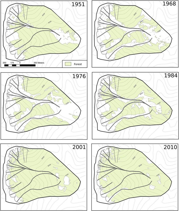
116                              Giacona and others: Avalanche activity and socio-environmental changes leave strong footprints in forested landscapes

                                                                                                          Finally, footprints of past human presence were mapped,
                                                                                                      such as footpaths, walls and enclosures or ruins of mountain
                                                                                                      farms. These markers were supplemented by various add-
                                                                                                      itional historical documents, notably the Napoleonic cadas-
                                                                                                      tre (first local edition: 1813), topographic maps and aerial
                                                                                                      photographs. Combining these with sources related to past
                                                                                                      avalanche events enabled us to put past avalanche activity
                                                                                                      within its context (an open or a closed landscape, intensity
                                                                                                      of the pressure on the wood resource, etc.), to even better
                                                                                                      grasp the characteristics of specific avalanches (their exten-
                                                                                                      sion via the location of a destroyed building, for example)
                                                                                                      and, more generally, to understand the evolution of the
                                                                                                      study area over the past two centuries.

                                                                                                      Airborne laser scanning
                                                                                                      The topography of the study area and the current state of
                                                                                                      forested slopes were characterised by Airborne Laser
                                                                                                      Scanning (LIDAR). LIDAR data were acquired by the
                                                                                                      Institute of Geographical and Forest Information (IGN) in
                                                                                                      March and April 2011. The vegetation was mainly in leaf-
                                                                                                      off condition, and snow remained on the ground in some
                                                                                                      high areas. The scanner was an Optech ALTM3100
                                                                                                      mounted on a fixed-wing aircraft flying at 290 km × h−1
                                                                                                      1500 m above the ground. The pulse frequency was 71
                                                                                                      kHz with a scan angle of ±16°. The mean point density
                                                                                                      obtained on the study area was 4.5 m−2. The TerraScan soft-
                                                                                                      ware was used for echo classification in both the ground and
                                                                                                      nonground categories.
                                                                                                         From the classified point cloud, two DEM were computed
              Fig. 2. Postcards of Mittlach (village located in the Munster valley,                   at 0.5 m resolution by bilinear interpolation of points classi-
              Alsace region, France) with, in the background, the Rothenbachkopf                      fied as the ground at locations of pixel centres. The digital
              summit and the Couloir en S (avalanche path number 1 of the study
                                                                                                      surface model (DSM) was computed by retaining the
              area, circled in red). (a) The flow path is densely forested before the
              avalanches of February 1952 (R. Herzog edition, circulating in July
                                                                                                      highest altitude of points in each pixel. The canopy height
              1952) and (b) largely open after their occurrence (Société Alsacienne                   model (CHM), representing vegetation height, was obtained
              d’Expansion Photographique, Colmar – Ingersheim, July 1964).                            by subtracting the DEM from the DSM. A smoothed 1 m
                                                                                                      resolution DEM was used to extract the topographic charac-
                                                                                                      teristics of the avalanche paths identified during the geo-
              morphologies (multiple leaders, decapitation, scars, etc.)                              historical inquiry (mean altitude of the release area, vertical
              were used as indicators to map avalanche-prone areas                                    drop, etc.; Table 2). Longitudinal and transversal canopy
              (Stoffel and Bollschweiler, 2008; Stoffel and Corona, 2014).                            transects were extracted from the CHM to better quantify
              This all made it possible to determine potential release                                the variability of the forest stand height as a function of the
              areas and the main flow paths throughout the study area,                                location within the study area. Specifically, two transects fol-
              and to precisely position intensity thresholds (i.e. the position                       lowing the contours at 1000 and 1100 m a.s.l. were con-
              within the path whose exceedance included the avalanche in                              sidered. Three longitudinal transects were also drawn: two
              a given intensity class). Note that other natural disturbances                          follow avalanche path profiles and one corresponds to an
              are truly extremely limited in the study zone. A limited rock-                          interfluve zone between two avalanche paths where trees
              fall activity exists on the northern slopes, but its role in                            did not show any visual marks of avalanche activity. These
              shaping the landscape can be considered as rather negli-                                transects were chosen to sample the variability of elevation
              gible. As a consequence, even if a few scars or specific                                ranges and forest cover heights over the study area (Fig. 3).
              stems that were met on the field were potentially attributable                             To characterise forest cover further in terms of species
              to rockfall events instead of avalanche events, this did not                            composition, the classification approach of Eysn and others
              preclude identifying avalanche-prone areas.                                             (2015) was used. A first discrimination was made between
                  To further assess the species composition of the forest                             conifers and broadleaved trees. In the second step, a distinc-
              structure, 1833 trees were pseudo-randomly chosen, identi-                              tion was made between pioneer and nonpioneer broad-
              fied and positioned with metric precision using a Trimble                               leaved trees. These two distinctions (in two or three classes)
              GeoExplorer GNSS (Global Navigation Satellite System)                                   are useful to understand forest landscape shaping by ava-
              receiver. This very large field sample covers the whole                                 lanche activity. Indeed, after a catastrophic avalanche, in
              study zone and all the variability of ages, stands and                                  the case of mixed forest stands, reforestation generally
              species that can be encountered when walking across the                                 involves first pioneer broadleaved trees, then nonpioneer
              study area. Although it is nonsystematic, this sampling is con-                         broadleaved trees and eventually conifers. The classification
              sidered to represent the specific diversity likely to be encoun-                        approach proposed by Eysn and others (2015) uses basically
              tered, as well as the relative proportions of the different                             the CHM and a field sample of trees belonging to the target
              species and their spatial variations within the study area.                             classes. Hence, our field sample was classified in two or

Downloaded from https://www.cambridge.org/core. 25 Dec 2021 at 11:50:04, subject to the Cambridge Core terms of use.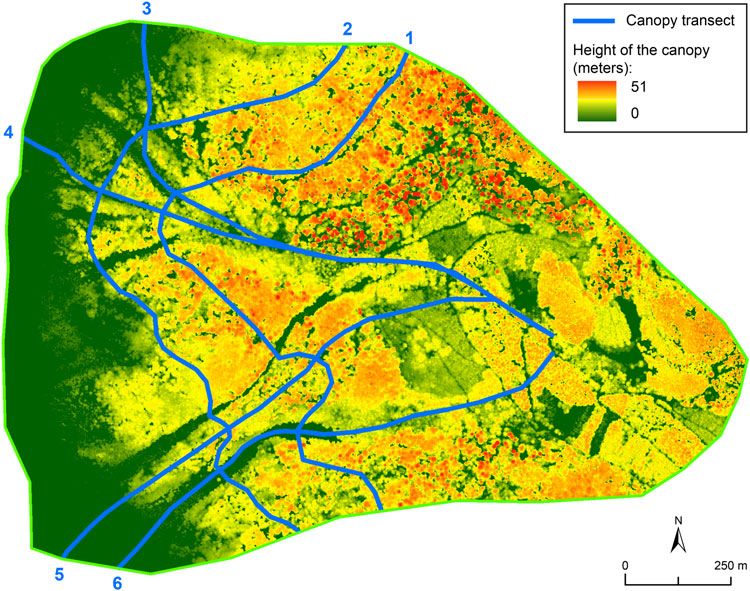
Giacona and others: Avalanche activity and socio-environmental changes leave strong footprints in forested landscapes                                         117

          Table 2. Characteristics of avalanche paths in the study area

                                                                                   Flow path                                         Release area               Historical
                                                                                                                                                                 activity
                                                   Path Length    Min               Max         Total      Mean        Mean Length   Mean          Mean
                                                   nb.         elevation          elevation     drop     elevation     slope       elevation     exposition      Nb. of
          Path name                                       (m)  (m a.s.l.)         (m a.s.l.)     (m)     (m a.s.l.)      (°)  (m)  (m a.s.l.)                  avalanches

          Couloir en S                              1      1160      732          1249         517       976           26.4   345   1236        NE              7
          Couloir du Torrent                        2      1311      757          1280         523       996           28.5   320   1266        NE              4
          Sommet du Rothenbachkopf                  3       321     1116          1300         185      1177           30.3   197   1264        NE              1
          Versant du Replat                         4      1333      768          1243         475      1037           26.3   377   1246        NE              9
          Combe du Leibelthal                       5      1264      826          1201         375      1008           24.0   180   1195        E              10
          Couloir du Col                            6      1245      771          1199         429      1001           24.4   114   1198        E               5
          Couloir du Chapeau                        7      1274      767          1218         450      1007           25.4   255   1213        SE              5
          Couloir Central Rainkopf Sud Est          8      1303      765          1262         497      1022           28.3   201   1257        SE              4
          Couloir 1305                              9      1340      745          1273         528      1009           28.1   127   1273        SE              2
          Couloir de la lisière/du Torrent         10      1349      745          1272         527       996           27.0   180   1264        SE              3
          Couloir du Col Sud                       17      1235      745          1194         449       918           21.2    82   1193        E               0
          Versant Rainkopf Sud                     18       320     1003          1233         229      1113           37.1   107   1228        SE              0
          Versant Rainkopf Sud bis                 19       299      996          1195         199      1091           36.1   136   1197        S               0
          Mean                                             1058      826          1240         414      1027           28     202   1233        /               3.8
          Standard deviation                                428      126            36         128        66            4.5    96     31        /               3.3

          Path numbers refer to Figure 1. Paths 1–10 are certain paths. Paths 17–19 are probable paths. Cornices can develop at the top of all paths, except paths 17 and 19.
          All path’s topographical characteristics were computed based on the 1 m resolution LIDAR-based DEM.

          three classes. Pioneer and nonpioneer broadleaved trees                                 with regards to the field sample for both the two- and
          were distinguished on the basis of the Landolt light index                              three-class procedures.
          value, an ecological indicator that assigns an integer
          between 1 and 5 to a given species, describing its potential
          to deal with light conditions. Here, a threshold of 2 for the                           Diachronic analysis
          Landolt light index was used. In addition to the CHM and                                The changes in forest cover were analysed from aerial photo-
          the field sample, classification efficiency was improved                                graphs and topographic maps (Appendix B). Aerial photo-
          with optical infrared colour (IRC) ortho-rectified aerial                               graphs are available from the mid-20th century. Six
          images acquired in 2010 by IGN. All in all, belonging to a                              photographs were selected: 1951, 1968, 1976, 1984, 2001
          species class was predicted throughout the forested parts of                            and 2010. Topographic maps cover a longer time span with
          the study area and cross-validation scores were computed                                six dates, from 1832 to 2007. The oldest map used is the

          Fig. 3. LIDAR-based canopy height model (CHM) of the study area (March–April 2011). Height of the canopy along transects 1–6 is provided
          in Figure 7.

Downloaded from https://www.cambridge.org/core. 25 Dec 2021 at 11:50:04, subject to the Cambridge Core terms of use.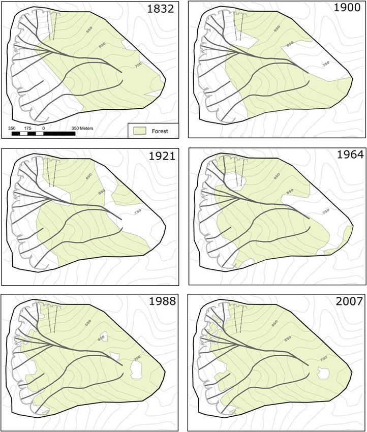
118                              Giacona and others: Avalanche activity and socio-environmental changes leave strong footprints in forested landscapes

              Etat-Major map, the first one sufficiently precise and detailed                         Table 3. Typology of avalanche events identified in the study area
              to map forest cover at the scale of the study area. Other maps
              correspond to key dates in terms of rural exodus and wars.                              Total number of events,                                                      60
                  Constitution of the topographic map corpus has been dif-                            precisely located at the path scale                                          50
              ficult because of the complex binational history of the study                           Intensity class                     1                                         5
              area. IGN provided the 1832 Etat-Major map and the most                                                                     2                                        10
                                                                                                                                          3                                         5
              current reference map (2007). Other maps were obtained
                                                                                                                                          3.5                                       2
              from the Strasbourg University library, from the Club                                                                       4                                         2
              Vosgien (a local hiking association which produced its own                                                                  4.5                                       1
              maps during a significant part of the 20th century) and from                                                                5                                         3
              private collections. Depending on the period, the maps                                                                      Unknown                                  32
              were published by IGN, the Karl Flemming Mapping                                        With slight environmental damage                                              7
              Institute in Berlin and/or the Club Vosgien (Appendix C).                               With severe environmental damage                                              7
                                                                                                      With destruction of one building                                              2
              Note that, for four out of six maps, the exact date of the topo-                        With one injured person                                                       1
              graphic survey could not be retrieved. The map is then con-                             With one person killed                                                        1
              sidered via its publication date. In this case, we cannot                               With two people killed                                                        1
              exclude a discrepancy with the actual state of the forest
              areas at the time of the survey, but it is expected to be low                           Intensity scale is from Giacona and others (2017a, b), briefly described in the
                                                                                                      text. For each event, intensity classes refer to the exceedance of the intensity
              (i.e. the Club Vosgien map published in 1968 corresponds
                                                                                                      levels positioned in Figure 1.
              to a survey conducted in 1964).
                  Maps and photographs were geo-referenced (in Lambert93
              coordinates). Aerial photographs were previously ortho-                                 Ruins of the old and the new Leibelthal farms are still
              rectified to apply corrections for optical distortions from the                         visible today (Fig. 5).
              sensor system and apparent changes in the position of                                       The existence of strong interactions between avalanche
              ground objects caused by the perspective of the sensor view                             activity and forests in the study area is reflected in the histor-
              angle and ground terrain. On each document, the forest                                  ical sources by the report of 14 avalanches that caused
              areas were carefully manually digitised. Comparing these                                damage to forest stands. For seven of these, that all occurred
              maps with the LIDAR-based DEM then made it possible to                                  after the winter 2003/04, the documented damage was slight.
              derive summary statistics (for each date: forest cover exten-                           The other seven destroyed (very) large forest stands in winters
              sion, mean altitude, maximum altitude, etc.), which allowed                             1846/47, 1907/08, 1951/52, and 2009/10. At the beginning
              quantifying the forest cover evolution in the study area over                           of February 1952, at least three avalanches destroyed ∼20 ha
              nearly two centuries.                                                                   of forest, leaving more than 3000 m3 of wood deposits (Fig. 2,
                                                                                                      Appendix D). Sources do not mention whether the ava-
                                                                                                      lanches of winter 1826/27 and March 1853 caused signifi-
              RESULTS                                                                                 cant forest damage. It is possible that the forest beyond the
                                                                                                      pastures was reached by the flow, but the information was
              Avalanche activity and related damage                                                   not recorded in the sources consulted.
              The study area is affected by significant avalanche activity                                Among the 60 avalanches identified, 50 could be located
              given that a total of 60 avalanches were identified between                             precisely at the paths scale. A total of 13 avalanche paths
              winters 1826–27 and 2013–14 by the Giacona and others                                   were mapped in the study area, ten of which are known
              (2017b) enquiry. A fairly regular occurrence of high-intensity                          with certainty since one to ten avalanches are documented
              avalanches over nearly two centuries is documented, but                                 in each of them by the sources. The three others are consid-
              overall the frequency of avalanches that were retrieved has                             ered as probable paths since only visible marks of avalanche
              increased since the 2000s (Fig. 3).                                                     activity could be spotted in the field, but no specific mention
                  In greater detail, our combination of refined field, histor-                        of past events was found in historical sources (Fig. 1c). Some
              ical and topographical investigations allowed documenting                               of the 13 paths already had local toponyms. The others were
              the spatio-temporal characteristics of several of these ava-                            named for the purposes of this study (Table 2). Nine of the 13
              lanches more precisely, notably those that caused significant                           paths converge at ∼850 m a.s.l. Only paths 1, 3, 17 and 19
              damage. Three avalanches caused casualties in 1850/51                                   do not converge with the main system. However, any of
              (two persons killed), 1999/2000 (one death) and 2010/11                                 the 13 paths is likely to be active independently of the others.
              (one person injured; Table 3). Similarly, avalanches in                                     Release areas are oriented mainly north-east to south, and
              winters 1826/27 and March 1853 (Fig. 4) impacted the                                    avalanches are likely triggered by the rupture of a cornice
              Leibelthal mountain farm that was exploited in the study                                (Fig. 1c). Average slope angles of the 13 paths vary between
              area at that time (Fig. 5). Historical sources report that the                          25° and 37°. Ten paths have a total length longer than 1 km
              farmer asked for permission to rebuild his farm, which con-                             and are likely to produce high-intensity avalanches (up to 5)
              sisted of a cottage and a barn. Specifically, in 1853, he                               that reach altitudes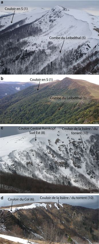
Giacona and others: Avalanche activity and socio-environmental changes leave strong footprints in forested landscapes                             119

          Fig. 4. Chronology of avalanches identified in the study area by the historical investigation. Along the x-axis, winter 1800 corresponds, for
          example, to the period from autumn 1800 to spring 1801. Environmental damage refers to avalanches that disrupted forest stands. Among
          these, after Giacona and others (2017b) we distinguished as severe environmental damage avalanche events that destroyed large forested
          areas.

          field survey, tree stands are dominated by Fagus sylvatica and                             Smoothing the CHM with a moving average filter removes
          Abies alba, which together account for more than 80% of the                             this small-scale spatial variability. This provides a better
          trees, almost equally distributed between the two species.                              understanding of the spatial structuring of tree heights,
          Approximately 10% of the trees are Acer pseudoplatanus.                                 namely the zones of the study area where trees are, on
          Ten other species of trees and shrubs were identified and                               average, more or less tall. Along altitudinal transects
          were more scarce, each accounting for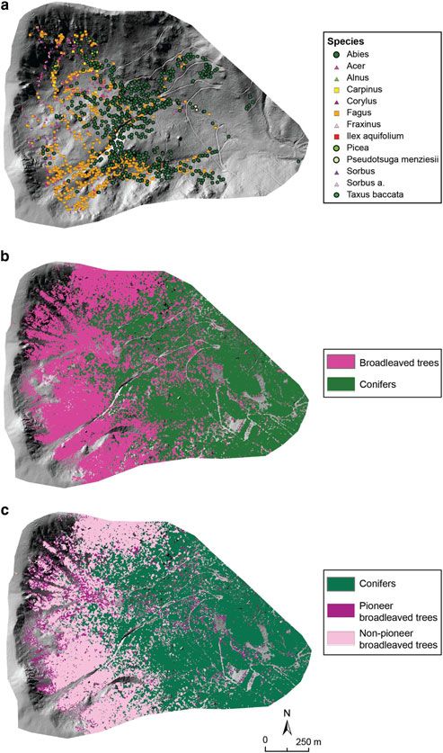
120                              Giacona and others: Avalanche activity and socio-environmental changes leave strong footprints in forested landscapes

              Fig. 5. Material stakes at risk in and around the Rothenbachkopf-Rainkopf avalanche complex: (a) farm buildings mentioned on the Etat Major
              map (survey in 1832), (b) extract of the cadastral atlas of Metzeral township corresponding to the study area (drawn in 1813, reworked after
              1889), (d) 2011 photograph of the ruins of the Leibelthal farm building that was destroyed by avalanches during the first half of the 19th
              century, (c) 2011 photograph of the ruins of the farm building that replaced it during the second half of the 19th century.

              Couloir du Chapeau (transect 4), for example, it reaches 10                             more complex. The beech-fir forest is replaced by pioneer
              and 15 m at 500 and 900 m, respectively, from the western                               species in active paths (Fig. 8a) or herbaceous species in
              margins of the study area. Canopy height shows a fairly                                 deforested areas (Figs 9c and d). Mapping the species
              similar trend in the Couloir de la Lisière/du Torrent, with,                            classes allows an assessment of the species organisation
              for altitudes between 1250 and 900 m, an increase in tree                               throughout the study area. Success rates in cross-validation
              heights well below that observed in zones not impacted by                               of 79% (two classes) and 68% (three classes) were obtained.
              avalanche activity (transect 5). However, the canopy profile                            These rather high values indicate that the mapped classes
              is even more disturbed for the Couloir en S (transect 6), with                          (Figs 8b and c) broadly reflect the empirical distribution of
              almost no live trees at altitudes above 1000 m a.s.l., which cor-                       species classes within the field sample (Fig. 8a).
              responds to the deforested zone clearly visible in Figure 3.                               In the immediate vicinity of avalanche release zones,
              Finally, at the bottom of slopes, (
Giacona and others: Avalanche activity and socio-environmental changes leave strong footprints in forested landscapes 121
Table 4. Typology of tree species identified in the field within the studied area
Latin name Common name Landolt light index Nb. % Species class Species class %
Abies alba Fir 1 709 38.7 Conifers 39
Picea abies Spruce 1 3 0.2
Pseudotsuga menziesii Douglas fir 2 2 0.1
Taxus baccata Yew tree 2 1 0.1
Acer pseudoplatanus Maple 3 200 10.9 Pioneer broadleaved trees 17
Alnus glutinosae Alder 3 6 0.3
Fraxinus excelsior Ash tree 3 24 1.3
Corylus avellana Hazel tree 3 7 0.4
Sorbus aucuparia Mountain-ash 3 48 2.6
Sorbus aria Beam 3 30 1.6
Ilex aquifolium Holly 2 2 0.1 Non-pioneer broadleaved trees 44
Carpinus betulus Hornbeam 2 19 1
Fagus sylvatica Beech 1 782 42.7
Total 1833 100 / 100
Nb. and % refer to the number and percentage of trees belonging to the species considered within the analysed sample. The analysed sample of trees is posi-
tioned in Figure 8a. Species class % is the empirical percentage within the field sample of the tree classes mapped throughout the study area in Figures 8b and 8c.
(below 900 m a.s.l.), conifers are even more dominant, but were afforested. In 1968 (first aerial photograph available
their heights remain more limited due to periodic logging. after 1952, Appendix B, caption C), the large paths of the
The species classification also shows comparable gradients area were reopened. In 1976, the forest area was minimal,
from the centre to the margins of avalanche paths, namely and the delineation of forest areas was very simple, probably
from deforested areas occupied by herbaceous vegetation due to the exploitation of the slope to clean residual forest
at the centre of the paths to an undisturbed mature forest at breakdowns. Afterwards, afforestation was very rapid, due
the far margins (Fig. 3). Hence, at the species level, ava- to the combined effect of natural recolonisation and, prob-
lanche paths are corridors for broadleaved tree species and ably, plantation of trees intended to erase the stigmas of ava-
even herbaceous species to penetrate at lower altitudes lanche damage at certain distant locations of runout zones
(Fig. 8c). This deeply shapes the visual aspect of the forest (Fig. 12). It is noteworthy that avalanches in winter 2009/
slopes and its high variability across seasons (Fig. 6). 10 (intensity 3–4) only slightly affected forest cover (−1%
between 2001 and 2010; Fig. 12) despite the significant
damage observed (reopening of paths 1–2 over fairly large
Landscape evolution over two centuries areas; Fig. 10). This highlights in contrast that the effects of
The diachronic analysis of historical maps and aerial photo- the 1951/52 avalanches (intensity 5) were extreme at the
graphs allows quantification of the forest evolution in the scale of the study area.
area since 1832 (Figs 10 and 11). According to topographic Changes in forest areas related to avalanche activity are
maps (Figs 12a and b), the forest area,122 Giacona and others: Avalanche activity and socio-environmental changes leave strong footprints in forested landscapes
and others (2017b) found no proof, either in historical
sources or in the field, of recent avalanche activity.
At the same time, the current forest landscape was
described through the forest canopy height and the species
composition (our two- or three-species classes). These two
metrics were evaluated in the entire study area by combining
field visits and LIDAR data. They truly characterise the large-
scale visual aspect of the slopes which we aimed to describe
and understand. It appeared that the natural altitudinal zon-
ation of the tree stands (heights and species composition)
remains visible only in the areas that are not (or very rarely)
affected by avalanche activity. Elsewhere on the slopes, the
forest structure is considerably different, which leads to the
conclusion that avalanche activity is indeed a significant
driver of the aspect of the forest landscape in the study
area. Specifically, forest stands present patterns that are lon-
gitudinally and transversely structured by the position of ava-
lanche paths. The visual aspect of these patterns varies across
seasons as a function of the species composition. Hence,
except in the Hautes Chaumes and in the lowest altitudes
of the study area where avalanche activity is almost absent
and where the landscape reflects above all pastoral and
forest exploitation, avalanche activity plays a major role in
the landscape genesis. We, therefore, postulate that the
landscape organisation of the area results primarily from a
quasi-equilibrium between forest stands and avalanche
activity (frequency of impacts, flow velocity pressure and
maximum height). In other words, the greater the avalanche
activity, the more one finds individuals, stands and species
that are able to cope with the impacts (resilience to impacts
via flexion, wound healing, adoption of specific morpholo-
gies, etc.).
Field observations in favour of the existence of such equi-
librium have already been documented by several previous
studies (e.g. Malanson and Butler, 1984; Veblen and others,
1994; Rixen and others, 2007). We arguably contribute
new evidence of this in the context of a mountain range
where interactions between avalanche activity and forest
stands are exacerbated since the treeline is close to or even
above the release areas. In addition, our results were obtained
using a combination of methods, including LIDAR data pro-
cessing, which has been, to our knowledge, rarely used for
Fig. 6. Visual aspect of the study area over the seasons: (a) in winter this purpose to date. This allowed computing detailed forest
2010, (b) in late summer 2015, (c) in winter 2009, and (d) in late metrics over the whole zone, which supplemented more trad-
spring 2016. Path numbers and names are provided in Table 2, itional field surveys and allowed an area-wide investigation of
and localised in Figure 1. the forest landscape. Hence, our approach appears to be a
useful complement to most of the recent studies that privilege
small-scale investigations of avalanche–forest interactions
Over the whole study period, the record of large avalanches and their ecological consequences on forest stands (e.g.,
and/or avalanches having caused damage is fairly regular. It Schönenberger and others, 2005; Bebi and others, 2009).
is, therefore, very likely that low-intensity avalanches also
frequently occurred in the area throughout the entire study
period but were not retrieved in the sources. Landscape opening – closure cycles due to major
From a spatial point of view, the historical enquiry identi- avalanches
fied past events on all except three paths of the study area. In Geo-historical and diachronic analyses show that the equi-
addition, on all 13 paths of the study area, clear visible marks librium between forest stands and avalanche activity is, in
of (rather) recent avalanche activity were identified by field the study area, fairly regularly disrupted by exceptional ava-
visits. As a consequence, all the study area’s paths may still lanches. These high-magnitude events destroy stands often
be active, even if it cannot be excluded on the basis of the reached by less severe avalanches and which are, therefore,
data analysed here that, at least for a few paths, avalanche according to Feistl and others (2015), more or less resilient to
activity is now less strenuous than it was earlier (see the impacts. They also reach mature stands located outside usual
section ‘Landscape evolution linked to changing human avalanche-prone areas. As documented – for example,
pressure and climate’). This situation differs from the lowest Takeuchi and others (2011) for a case study in Japan – the
elevation sites of the Vosges Mountains where Giacona result is an opening of the landscape over large and wide
Downloaded from https://www.cambridge.org/core. 25 Dec 2021 at 11:50:04, subject to the Cambridge Core terms of use.Giacona and others: Avalanche activity and socio-environmental changes leave strong footprints in forested landscapes 123
Fig. 7. Height of the canopy in March–April 2011 along transects of the study area. Transect numbers correspond to Figure 3. Canopy heights
were evaluated along transects from the CHM (Fig. 3). Path numbers correspond to Figure 1 and path names to Table 2.
areas (Fig. 2), at the end of which a large volume of wood is forests seem to have occurred fairly regularly in the zone over
deposited (Fig. 9). At this abrupt opening of the landscape the study period, every 50 years or so (that avalanches that
follows a re-closing of the landscape spanning a few caused severe environmental damage in Fig. 3).
decades. All in all, avalanche activity structures the forest landscape
Over the entire study period, this type of cycle seems to of the zone not only through equilibrium in which the loca-
have occurred four times, following the major avalanches tion of the different stands does not change over time. In add-
documented during the winters 1846/47, 1907/08, 1950/51 ition, the slopes evolve in a quasi-cyclical manner, where the
and 2009/10. The last cycle is in progress, with the re-colon- observable landscape depends on the time of the opening-
isation of the post-event landscape already started (Fig. 9e). closing cycle. In particular, the characteristics of stands
The previous cycle, following the even greater number of (size of the individuals, species) visible at a given location
avalanches of winter 1950/51, was well documented with evolve over time according to the growth rates of tree indivi-
aerial photographs. In124 Giacona and others: Avalanche activity and socio-environmental changes leave strong footprints in forested landscapes
land abandonment and afforestation that prevailed during the
study period over the Vosges Mountains is quite obvious as
well for the study area. Although the cessation of pastoral activ-
ity in Leibelthal could not be precisely dated, it is certain that
the ‘new’ farm remained in a state of ruin after the Second
World War (Matter, 2010). At the same time, an impact in
the study area of the reforestation policies conducted at the
scale of the massif is likely, as suggested by the regular stands
of young conifers we identified at elevations below 800 m a.
s.l. Hence, changing anthropogenic pressures over the study
period was clearly responsible for a dramatic forest cover evo-
lution in the study area. We were able to document the signifi-
cant elevation of the tree line since 1832 from historical maps
and photographs, and the current presence of pioneer broad-
leaved trees was mapped in the immediate vicinity of the
ridges, tangible proofs of this major landscape closure dynam-
ics. This landscape closure resulting from agriculture abandon-
ment and reforestation is not surprising because it has been
documented in many mountain ranges in developed countries
over the last two centuries. Its dynamics were of variable tem-
porality and intensity depending on the social contexts but the
phenomenon has often accelerated since the end of the Second
World War (e.g. Moriniaux, 1999; Deuffic, 2005; Labrue,
2009; Spielmann and others, 2013).
These changing anthropogenic constraints on the environ-
ment may have combined with the climatic context of the
late LIA. Indeed, at the beginning of the study period,
regular exploitation of the area was concomitant with a
colder and, to a lesser extent, less humid climate
(Appendix A), which limited the extent of the forest, particu-
larly in the upper slopes of the study area. Then gradual
warming associated with a slightly wetter climate occurred
at the same time as pastoral pressure decreased, which
resulted in rapid afforestation. We do not exclude that the
climate warming context was not necessary for the landscape
closure to occur, but it seems reasonable to postulate that it
Fig. 8. Spatial distribution of tree species in the study area: (a) Trees has accelerated the afforestation process by creating condi-
identified by direct field investigations conducted between 2014 tions more favourable to tree colonisation and growth.
and 2017 (Table 4), (b) results of the 2-class classification of tree Furthermore, by decreasing snow amounts and hence the
species, (c) results of the 3-class classification of tree species. propagation of avalanche events downslope, climate
warming may also have indirectly sped up the reforestation
process. We cannot provide any quantitative assessment
Landscape evolution linked to changing human pres- over the entire study period of natural avalanche activity
sure and climate response to climate change in the study area on the basis
In the long history of resource exploitation of the Vosges of the data available. This is because of the strong impact
Mountains, the beginning of the study period corresponds of historical sources on the homogeneity of avalanche
to a phase of landscape opening stemming from the combin- records (Giacona and others, 2017b) that precludes from
ation of pressures exerted on the forests by agro-pastoral easily inferring avalanche–climate linkages over the long
practices and proto-industrial activities consuming wood range, in the Vosges Mountains like elsewhere (e.g. Eckert
(Garnier, 2004). At the much more local scale, it is clear and others, 2013; Ballesteros-Cánovas and others, 2018).
that the Rothenbachkopf-Rainkopf avalanche complex was However, our historical enquiry truly documents, despite
particularly marked by agro-pastoralism. According to the the overall recent increase on the record, more extreme
cadastre and the État-Major map, many mountain farms and/or highly destructive avalanches in the distant past,
were active in the immediate vicinity of the study area with no more intensity five avalanches since winter 1950/
during the 19th century (Matter, 2010) including the 51, and several intensity five avalanches that caused building
Leibelthal area, which was destroyed several times by ava- destructions, major forest damage and killed people during
lanches during the 19th century. This farm already existed the 19th century. This is consistent with the existence of
at the beginning of the study period since it is known that extinct avalanche sites at lower elevations in the Vosges
there were 11 cows there in 1796 (Matter, 2010). Mountains. Such qualitative hints suggest that avalanche
It was estimated that, in the Munster Valley where our activity has truly decreased in the study area as the climate
study area is located, during the 1970s 4800 ha of the surface was warming, at least in terms of the magnitude of the
that were no longer grazed were evolving to more or less events. By releasing a disturbance agent that previously
shrubby moors (Établissement National d’Enseignement limited forest colonisation of the upper slopes, this may
Supérieur Agronomique, 1995; Simon, 2002). This context of have contributed to landscape closure in the area.
Downloaded from https://www.cambridge.org/core. 25 Dec 2021 at 11:50:04, subject to the Cambridge Core terms of use.Giacona and others: Avalanche activity and socio-environmental changes leave strong footprints in forested landscapes 125
Fig. 9. Landscape footprints of the 2009/10 major avalanches in the study area: (a, b) devastated post-avalanche landscapes in spring 2010
(Couloir du Torrent – number 2); blooming Digitalis pupurea in summer 2014 in opened areas of (c) Couloir en S – number 1 and (d) Couloir du
Torrent; (e) opened area and beginning of forest recolonisation in summer 2010 (Couloir du Torrent seen from the ridge).
Wider relevance of the results obtained to allow a regular avalanche activity and that the climate is
Even if we have never attempted to extrapolate our data mild enough to allow the development of a forest cover over
outside the study area, we are convinced that similar a significant part of the paths, as suggested by the good agree-
results could have been obtained for the majority of the ment between our results and the already existing literature
other nearby circuses. The Rothenbachkopf-Rainkopf regarding forest stand organisation and avalanche activity
complex has indeed been chosen as representative of the and the opening effect of major avalanches.
glacial circus constituting the eastern edge of the Vosges In terms of long-term evolution, the climatic context of
Mountains in terms of biophysical parameters (tree stands, accelerated global warming over the last few decades is a
geomorphology, prevailing climatic conditions, Flageollet, worldwide reality (IPCC, 2013), but the evolution of the pres-
2003; Goepp, 2007; Wahl and others, 2009). However, as sures exerted on the territory is extremely variable from one
stated above, although the social context remains broadly massif to another. Therefore, landscape dynamics during
comparable at the scale of the entire Vosges Mountains the last few centuries in response to avalanche activity,
(agro-pastoral abandonment and reforestation), local dispar- climate and human pressure may have been much different
ities (continuation, development or cessation of pastoralism from one mountain range to another. Due to the current
and/or logging, etc.) may have caused differentiated land- lack of quantitative studies addressing the area-wide land-
scape trajectories over the long term in a few specific loca- scape dynamics response to these three drivers combined
tions. Testing these hypotheses will require reproducing the together, comparison with other results is difficult. It can be
analysis with a similar methodology on other nearby areas. reasonably estimated that, in many mountain ranges affected
Similarly, it is likely that the results obtained in terms of the by avalanche activity, the influence of humans was less
landscape impact of avalanche–forest interactions remain durable and less intense than in the Vosges Mountains, espe-
relevant over an even wider area in temperate mountain cially outside Europe. In such cases, the avalanche–forest
ranges, especially medium-high ranges. For this, it is a priori interaction and climatic patterns may well be the main
only required that the slopes and the snow cover are sufficient factors at play. However, results similar to ours could
Downloaded from https://www.cambridge.org/core. 25 Dec 2021 at 11:50:04, subject to the Cambridge Core terms of use.126 Giacona and others: Avalanche activity and socio-environmental changes leave strong footprints in forested landscapes
Fig. 10. Forest cover in the study area for 6 years (in black in the top-right corner) based on ortho-rectified aerial photographs.
probably be obtained in many medium-high mountain because of the (relatively) small size of the study area. The
ranges of developed countries that have been submitted to time necessary was, therefore, reasonable while it allowed
the same socio-environmental changes over the last few precision that could not have been reached with an auto-
centuries. matic procedure, in particular for the oldest topographic
The profound footprints of human activity in the landscape maps. Working both on maps and photographs to establish
of the Vosges Mountains are related to their long history, and the diachronic evolution of the forest cover combined the
hence to their rich cultural heritage. This substantially strengths of the two types of sources. Estimates provided by
increases the complexity of landscape genesis (for instance, aerial photographs are more variable from one date to
the ‘initial state’ for now appears out of reach) with regard another, which is related to their higher resolution. This
to massifs where human influence is much less perceptible. allowed capturing detailed changes in forests, difficult to
As a corollary to such difficulties, rich information can be grasp from the sole analysis of topographic maps. The poten-
collected in various archives over long periods, which is tial of the latter for precisely measuring the impact of ava-
impossible in barely and/or recently populated areas. The lanche activity on forest stands appeared to be more
long-lasting human occupation and relatively modest size limited. However, the area-wide summary statistics (surfaces,
of massifs like the Vosges Mountains, therefore, make them altitudes, etc.) provided by maps and photographs over the
valuable living laboratories for the study of the trajectories recent period have proved to be comparable (Fig. 11). This
of socio-environmental systems over recent centuries. satisfactory agreement, particularly in view of the probable
low accuracy of the forest surfaces derived from the topo-
graphic maps, suggests that the latter are indeed sufficient
Pro and cons of the chosen approach and outlooks to roughly quantify the forest evolution over the study area
For the mapping of forest areas, manual digitalisation was for the entire post-1832 period.
preferred over automatic processing for both historical Also, one may express doubts regarding our tree species
maps and aerial photographs. This approach was possible classification approach. In the literature (Eysn and others,
Downloaded from https://www.cambridge.org/core. 25 Dec 2021 at 11:50:04, subject to the Cambridge Core terms of use.You can also read