AVIATION WEATHER - MicroStep-MIS
←
→
Page content transcription
If your browser does not render page correctly, please read the page content below
COMPLEX SOLUTIONS FOR THE REAL WORLD

AVIATION WEATHER
AUTOMATED WEATHER OBSERVATION SYSTEM
                    ATIS/VOLMET   Datalink   VHF transmitter                                      Central System

                                                                 Forecasting                                        Air Traffic Navigation Systems
                                                                 Workstation                                        Low Level Windshear Alert System
                                                                                                                    Upper Air Sounding Systems
                                                               Meteo Observer's                                     Weather Radar
                                                                 Workstation
                                                                                                                    Satellite receiver
                                                                                                                    NWP model
                                                                 Maintenance
                                                                 Workstation                                        GTS
                                                                                                                    AFTN/amhs

                                                                                             Media
                                                                                           Converter

                                                                                                                                    Aviation Weather
 Runway State
                                                                                                                                        Displays
   Sensors

21R

                                                                                   All sensor's
                                                                                  Data to Media
                                                                                    Converter

                                                                                                                   03R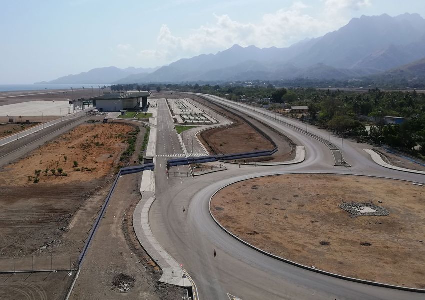
EXPERTS IN AVIATION METEOROLOGY                                                                                                CONTENT
Aviation weather solutions constitute the majority and        IMS4 integrated monitoring system is a complex                   Field Measurement System                          6
the most remarkable part of MicroStep-MIS product             multipurpose software that has been in development since
portfolio. The company has officialy been certified as an     1993. The system is designed for nonstop unattended              IMS4 Automated Weather Observation System         8
air navigation service provider by Civil Aviation Authority   operation and it has already been installed in various
of the Slovak Republic (accredited by the European            countries all over the world.                                    IMS4 Metreporter                                 12
Aviation Safety Agency).
                                                              High level of customization allows each of our systems to        IMS4 Helideck                                    13
The company’s aviation systems are suitable for civil         adapt to the individual requirements and needs of each
regional, national, international airports scalable to ICAO   client. Due to the constant development of standards and         IMS4 Low Level Windshear Alert System            14
CAT III category, as well as military airports and NATO       technological progress the upgrades and actualization
airbases. The systems are ICAO and WMO compliant and          of the systems form an integral part of MicroStep-MIS               Lidar for Detection of Low Level Windshear    16
adaptive to various climatic conditions and local practices   activities.
of each region.                                                                                                                IMS4 Airport Runway Weather Information System   18

                                                                                                                                  Recent Improvements                           19

                                                                                                                                  Aquaplaning Assessment and Nowcasting         20

                                                                                                                               IMS4 ATIS / VOLMET                               22

               330+                                      30                             200 mil.+                              IMS4 Pilot Briefing                              23
           aviation systems                      supplied countries                    served passengers
                                                                                                                               IMS4 Runway Visual Range System                  24
               since 1995                             worldwide                               annually
                                                                                                                                  Fog Modeling and Forecasting                  25

                                                                                                                               Aeronautical Climatological Database             26

                                                                                                                               IMS4 Aviation Weather Decision Support System    28

                                                                                                                               SESAR | From Research to Innovations             30

                                                                                                                          Aviation Systems                                       5
FIELD
MEASUREMENT
SYSTEM
AIR TEMPERATURE AND ATMOSPHERIC DATA LOGGER LIGHTNING CAMERA
RELATIVE HUMIDITY PRESSURE DETECTION
MicroStep-MIS aviation weather systems are
designed to interface various types of sensors and
data loggers. In-house development and production
of hardware components as well as long lasting
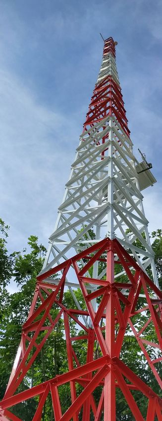
relationships with our suppliers allow us to deliver Meteorological mast for wind X-BAND WEATHER LIDAR WIND SPEED AND VISIBILITY AND
RADAR DIRECTION PRESENT WEATHER
tailored solutions to our clients. measurement | installed in Jakarta
as a part of IMS4 Low Level
Windshear Alert System
Top class among barometers
Digital Barometer MSB780 is designed for use in
professional meteorological and aviation applications CLOUD PRECIPITATION SOLAR RUNWAY SURFACE METEOROLOGICAL
COVERAGE RADIATION CONDITION DISPLAY
that require reliable and highly accurate measurement,
fast dynamic response and advanced long-term
stability. The barometer is built to withstand the
most challenging environmental conditions, which
are often faced in various environmental monitoring
applications.
RUNWAY SELECTOR THE SELECTED AVERAGING MODE
(2-MIN, 10-MIN OR INSTANTANEOUS)
It is a low power consumption microprocessor
controlled sensor suitable also for solar and battery
AIR TEMPERATURE
powered applications. The sensor is operable in
temperature range from -50 °C to +80 °C. The excitation MENU BUTTON
DEW POINT TEMPERATUE
range is from 5 to 35 V DC. This robust product is made
of durable hardware components enclosed in heavy-
ATMOSPHERIC PRESSURE
duty metal IP 66 enclosure. It comes factory calibrated ‘REDUCED’ TO MEAN SEA LEVEL
with a manufacturer calibration certificate. WIND DISPLAY
THE PRESSURE
CORRECTED TO THE
Universal meteorological display OFFICIAL AIRFIELD
WIND VALUES ELEVATION
MD14 is a universal display for professional
meteorology use designed for airports and industry RUNWAY VISUAL RANGE
as well as for meteorological stations as a lightweight
replacement of the observer’s screen or redundant LOWEST CLOUD
RUNWAY
backup to it. BASE LEVEL
The LCD display MD14 presents real time CROSSWIND
meteorological data as well as data calculated
according to WMO and ICAO standards and
recommendations. It supports configuration of up to
5 information tabs – typically used for 4 runways and
a meteorological garden. MD14 comes preconfigured
to one of the standard configurations; however,
additional configurations can be ordered as per Universal Meteorological Display MD14 | The most
client’s requirements. complete configuration for aviation display for ATC TWR
6 Aviation Systems Aviation Systems 7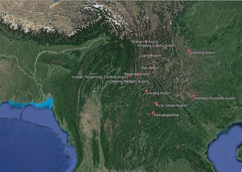
IMS4 AUTOMATED WEATHER
OBSERVATION SYSTEM
IMS4 Automated Weather Observation System is regarding the measurements and reporting. It calculates different deicing materials, runway condition (dry / damp
an airport weather observation system for regional, various derived meteorological data such as QNH, QFE / wet / ice, etc.), visibility and RVR, cloud height, sunshine
national and international airports. The IMS4 AWOS and Runway Visual Range, generates alarms, METAR, duration, solar and gamma radiation, evaporation, O3 THE COMPLETE
measures, processes, stores, presents and communicates SPECI, SYNOP reports as well as national codes if required. concentration and it is open for adjustments and addition HARDWARE
all meteorological data at the airport. of any other quantities if needed.
AND SOFTWARE
The system can interface numerous types of data
The system integrates and provides weather data to loggers and sensors. It is designed to measure, calculate The Central System is used as a central node for all SOLUTION
observers, air traffic controllers, pilots and other users and process different meteorological quantities such as communication networks and interconnects field sensors,
in form of real-time screens, graphs, WMO codes, temperature (dry, surface, soil, soil under vegetation), wind displays and individual stations installed on the airport,
alarms and voice reports. It interfaces upper air systems, speed and direction, pressure (station, QNH, QFE, QFF), thus enabling to backup these networks. The Central
low level windshear alert system and radars.The IMS4 relative humidity, precipitation (indicator and amount), System makes all preprocessed data available to IMS4
AWOS conforms to all ICAO and WMO recommendations runway surface temperature, freezing temperature for Workstations and remote displays, thick or thin clients.
DATA
RUNWAYS MET GARDEN SERVER ROOM DATA OUTPUTS
SOURCES
CEILOMETERS SUN DURATION
GTS GTS
GLOBAL RADIATON REMOTE
16R 16C 16L REMOTE AFTN AFTN NETWORK
TA + RH TA + RH NETWORK
WS + WD OUTPUT
AMHS AMHS
PRECIPITATION INPUT
FS/BL SATELLITE
WIND SPEED + WIND DIRECTION
RECIEVER
AIR PRESSURE
CENTRAL SYSTEM AIR TRAFFIC
THUNDERSTORM CONTROL OUTPUT
LOCAL RADAR (DUAL HOT-FAILOVER)
FS
MASTER CLOCK IMS TERMINALS
DATALOGGER LOCAL OBSERVER'S PC + BACKUP
UPPER AIR
FS INPUT
LLWAS FORECASTING PC + BACKUP
RLSI AWD
GPD
DEVICE SERVER /
TA + RH MEDIA CONVERTER BRIEFING
WS + WD
34L 34C 34R ATIS + VOLMET
FS FIBER OPTIC OR FSK MODEMS
MAINTENANCE
OR RADIOMODEMS OR WIFI
WORKSTATION
CEILOMETERS
IMS4 AWOS scheme example for
CAT II or CAT III airport
8 Aviation Systems Aviation Systems 9
The configuration and structure of a respective AWOS       lifetime. The IMS4 application software is capable to build
                                                          MicroStep-MIS’ IMS4 AWOS has been installed at     system depends on size and category of the individual      the virtual multirunway Automated Weather Observation
                                                          Oecusse International Airport of East Timor        airport. The modular architecture allows expansion         System collecting real-time raw or processed AWOS data
                                                                                                             from single Aviation Weather Display with basic set of     from several regional airports and presenting them to the
                                                                                                             sensors up to comprehensive system for multirunway         operators in the form of the virtual multirunway AWOS
                                                                                                             airport connected to GTS and AFTN networks including       system with multiple runways.
                                                                                                             a dual hot fail-over Central System, several Observer’s
                                                                                                             Workstations, displays, terminals, briefings and ATIS /    Within the same airport, or on the other continent, IMS4
                                                                                                             VOLMET services.                                           AWOS provides users with the powerful and efficient web
                                                                                                                                                                        interface. All the user needs in order to view the AWOS
                                                                                                             The well-developed upgrade programs allow our              data is a standard web browser and Internet connection.
                                                                                                             systems to follow technology progress and adapt to
                                                                                                             airport expansion and changes in regulations during its

                  FROM SMALL REGIONAL AIRPORTS OR
                 HELIPORTS SCALABLE UP TO ICAO CAT III
                MULTIRUNWAY OR MULTI-AIRPORT SYSTEMS

12 airports of Chinese Yunan Airport Group integrated
into virtual multi-runway Automated Weather Observation                                                                          Example of multi-runway aviation weather display designed and customized
System                                                                                                                            according to customer’s requirements. Parameter tendencies are marked by
                                                                                                                                    colors - deterioration is marked by red and improvement by green color.

      10                                                                                  Aviation Systems    Aviation Systems                                                                                            11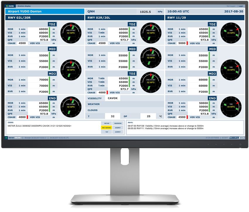
IMS4 METREPORTER
 IMS4 MetReporter is built on a modular IMS4 AWOS         •   Remote telemetry and control from local workstation
 platform and it is an autonomous, easy-to-deploy and         over WiFi or GPRS VPN
 maintain fully automated weather observation system      •   Optional computer based IMS4 Aviation Weather
                                                                                                                                   HELIDECK
 for general aviation, non-ICAO airports and heliports.       Display or full featured IMS4 Observer Workstation                   WEATHER STATION
                                                          •   Optional data reporting to the upper system for flight
 The system consists of:                                      planning (i.e. via cloud computing provider)
                                                                                                                                                                                             VISIBILITY AND PRESENT
 • Embedded VHF Automated Terminal Information            •   Meets or exceeds applicable ICAO, WMO, EASA, CAAC                                                                              WEATHER SENSOR
     Service                                                  regulations and recommendations
 • Embedded Automated Weather Observation Service                                                                                                                WIND SPEED
                                                                                                                                                       AND DIRECTION SENSOR

                                                                              WIND
                                                                              SPEED SENSOR
                                                                                                                                       RELATIVE HUMIDITY AND
                                                                                          WIND                                          TEMPERATURE SENSOR
                                                                                          DIRECTION SENSOR

                                                                                                                                  CLOUD COVERAGE
                                                                                                                                          SENSOR
            METREPORTER
            WEATHER STATION
                                                                                               CAMERA

                                                                                                                                                                                                     WATER LEVEL
                                                                                                                                                                                                     RADAR SENSOR
VISIBILITY AND PRESENT
      WEATHER SENSOR

             RELATIVE HUMIDITY AND
              TEMPERATURE SENSOR                                                                                       IMS4 HELIDECK
                                                                                                                       IMS4 Helideck Monitoring System is optimized to              barometric pressure, visibility and present weather,
                                                                                      RAIN GAUGE
                                                                                                                       provide real-time weather conditions and monitoring          cloud height and wave height. In addition, the IMS4
                                                                                                                       of the helideck motion, thus ensuring the flight and         Helideck monitors the helideck’s heave, heave velocity,
                                                                                                                       passenger safety.                                            roll, pitch and inclination in real-time. The automatically
                                                                                                                                                                                    generated helideck reports can be disseminated through
                                                                                   CLOUD COVERAGE                      The monitored weather parameters include wind speed          various communication channels or optionally broadcast
                                                                                           SENSOR
                                                                                                                       and direction, air and sea temperature, relative humidity,   to pilots via VHF transceiver.

       12                                                                                           Aviation Systems    Aviation Systems                                                                                              13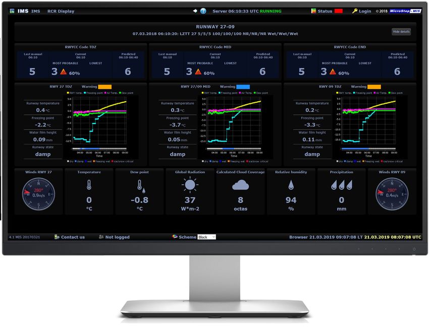
IMS4 LOW LEVEL
WIND SHEAR
ALERT SYSTEM
IMS4 LLWAS is the top-quality, automatic and reliable
product considerably approaching technology to mitigate
the riskiness of crucial flight phases of take-off and
landing. The system is used by controllers to warn pilots
of existing or impending windshear conditions.
Network of wind stations installed and situated near and
along the airport runways measures average surface wind
speed and direction. The system collects the measurements,
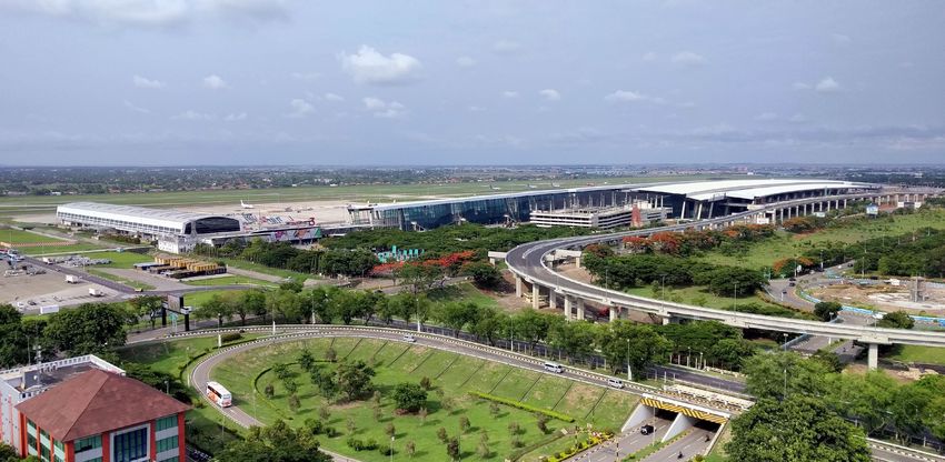
performs the validations and recalculations, runs the Soekarno-Hatta International Airport, Jakarta |
algorithm to detect wind shear, generates the alerts and MicroStep-MIS IMS4 LLWAS assists the operations
distributes the data and alerts to displays and 3rd party at 18th businest airport worldwide, serving more than
systems. Selection of proper sites and optimization of the 63 million passengers annually (2017)
algorithm are crucial for the site surveying teams.
System integration with IMS4 AWOS system is available
and possible bringing even more comprehensive, relevant,
and highly useful data to the airport teams allowing them
to significantly decrease the risk of a sudden disaster.
LLWAS Expert Display | It contains schematic view of runways, wind shear alert system measuring sites in the surroundings IMS4 LLWAS Total Screen | Airport visualization - map, actual warnings, wind data (digits or wind barbs), active alerts
and wind shear alerts. There are also computing triangles and detail messages that are inter-results of computing of wind marked on the map by red color
shear alert system. It is intended for LLWAS experts to inspect the situation.
14 Aviation Systems Aviation Systems 15
LIDAR FOR DETECTION
OF LOW LEVEL WIND SHEAR
Detection of low level wind shear and timely automated                                                            the Slovak Research and Development Agency MicroStep-
warnings on it play a key role in the aviation safety, mostly in                                                  MIS purchased a lidar and installed it at Bratislava airport.
the phase of landing or take-off. Rapid advancement of new
technologies based on lidars and / or small weather radars                                                        The target destination, M. R. Štefánik Airport in Bratislava,
and their penetration into operational practice worldwide                                                         had been selected mostly on the basis of being the largest
result in the fact that the detection of low level wind shear                                                     and the busiest one among the airports in Slovakia, and as
is being transformed into an integration and evaluation of                                                        well on due to the orography and the climatological settings
multi-platform observations.                                                                                      of the target area forming adequate circumstances for a
                                                                            THE 1ST LIDAR                         (frequent) birth of hazardous meteorological phenomena
Besides the traditional technology of low level wind shear                  IN CENTRAL                            such as wind shear.
detection (based on synchronized wind observation by
anemometers) MicroStep-MIS upgrades the alerting                              EUROPE                              The aim of the research project is to collect and analyze
system by having a lidar-based technology integrated.                                                             large number of synoptic situations with wind shear, and
                                                                                                                  to develop our own, automatic, lidar-based low level wind
Within the research project A Novel Method for Low-level                                                          shear alert system.
Wind Shear Alert Calculation from Data Measured by
LIDAR (2016 – 2020) and with a financial support from

                                                        ~3 nm
                                                                                                                                                                                  AEROSOLS

                                                                                   MOVEMENT OF AEROSOLS BY WIND
       ~1000 ft

                                                                                                                                                    LASER PULSE REFLECTED FROM AEROSOLS

                                                                   PPI 3°

                                                                                                                                                                                             Lidar detects the frequency change of the
                                                                                                                         EMITTED LASER PULSE                                                            backscattered pulse
                                               RUNWAY SURFACE                     LIDAR                                                                                                            (hence, the radial wind speed)
                                                                                                                                                                                                 on the basis of the Doppler effect

       16                                                                                 Aviation Systems         Aviation Systems                                                                                                17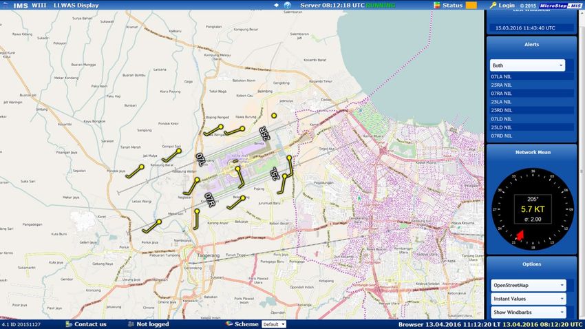
IMS4 AIRPORT RUNWAY WEATHER
INFORMATION SYSTEM
Using the real-time collected measurements from the           and subsurface sensors or non-intrusive optical sensors
field sensors as well as the data from the integrated         provide runway and subsurface temperature, freezing point,
model, the IMS4 ARWIS provides the airport authorities        water film thickness and runway condition (dry, damp, wet,                                    READY FOR 2020:
with the essential runway surface condition data.
Generated early warnings contribute to air traffic safety
                                                              snow, ice, etc.).
                                                                                                                                                              NEW GLOBAL
and assist the maintenance service with planning the          The optional automatic weather stations measure                                                 REPORTING
runway maintenance activities.                                atmospheric pressure, wind speed and direction,
                                                              temperature / dew point, present weather, precipitation,
                                                                                                                                                                FORMAT
The system interfaces numerous types of sensors and           snow depth and the system is open for measurement and
data loggers. The active / passive intrusive runway surface   processing of the other quantities.

                                                                                                                           RECENT
                                                                                                                           IMPROVEMENTS
                                                                                                                           Being involved in the SESAR research
                                                                                                                           projects, MicroStep-MIS has significantly
                                                                                                                           improved and upgraded the IMS4 ARWIS
                                                                                                                           within the Solution PJ03b-06 - Safety
                                                                                                                           support tools for runway excursions.

                                                                                                                           The system is now fully compliant with the
                                                                                                                           new ICAO Annex 14, 7th Edition, Amendment
                                                                                                                           13b, ICAO Annex 15, 15th Edition, Amendment
                                                                                                                           39b, ICAO Doc 9981, 2nd Edition introducing
                                                                                                                           new Global Reporting Format, all applicable
                                                                                                                           from 5th of November 2020.

                                           Airport Runway Condition Display

      18                                                                                                Aviation Systems    Aviation Systems                                  19
AQUAPLANING ASSESSMENT
Meteorological radar
AND NOWCASTING
The newly featured IMS4 ARWIS has recently been Moreover, implementation of prediction model is beneficial
deployed and integrated at Malta Luqa Airport. Integration in order to access better quality of consolidated data
of aquaplaning into the system, compliant with current ICAO necessary for winter runway maintenance. Graphical user
regulations (implementation of Runway Condition Report) interface can be customized according to the particular
and additional integration with radar-based nowcasting requirements of the customer.
enable the system to provide and generate more precise
RWY condition assessment.
Runway surface
measurement sensor
Aquaplaning / precipitation display shortly after the storm Precipitation sensor
Laser precipitation monitor
Temperature and relative
humidity sensor
Radar display shortly after the storm
20 Aviation Systems Aviation Systems 21IMS4 ATIS / VOLMET
The IMS4 ATIS / VOLMET system benefiting from more Variety of system options include but are not limited to:
than 25 years of MicroStep-MIS’ experience in the field of
meteorological service for civil aviation provides arrival, • Multiple channels and / or multiple languages
departure or combined ATIS and VOLMET broadcast and • Dual hot-failover configuration and / or redundant
datalink services for airports from regional up to major transmitter equipment as a guaranty of the highest
international airports. possible system reliability
• Remote operator and control positions for convenient
The system can be installed as a standalone or as an authorized access to the system
integrated part of the company’s IMS4 AWOS with • Telephone interface for the preview of current
permanent access to the AWOS data. broadcasted reports
The open architecture allows easy expansion from the basic The semi automated or manual mode can be also configured
single channel system (combined departure and arrival ATIS for specific channels, if required, with visual and audible
service) up to the multi-channel ATIS / VOLMET system warnings announcing new data availability and new report
(separate broadcasting channels for airport with multiple compilation.
runways, multichannel service for group of airports etc.).
AWOS DATALINK (SITA, ARINC)
LLWAS
ARRIVAL ATIS TRANSMITTER
ATIS / VOLMET
SINGLE OR DUAL
PHONE INTERFACE
HOT-FAILOVER SYSTEM DEPARTURE ATIS
TRANSMITTER
GTS
VOLMET TRANSMITTER
Photo by Blake Guidry | unsplash.com
AFTN
ATIS IDENTIFIER DISPLAYS
IMS4 PILOT BRIEFING
WEB
IMS4 Pilot Briefing supplies meteorological information documentation containing the local conditions, conditions
LOCAL VOICE REPORT to aviation users in order to ensure the safety and at the destination and along the flight route. A single
MONITORING
regularity of air navigation. definition of the flight route into the system is sufficient
GPS for the system to master this task in a few seconds time.
The workstation facilitates collecting and printing of flight
documentation for pilots based on the local meteorological The system also warns users about all received
IMS ATIS VOLMET CONSOLES
data and messages received from GTS or AFTN networks. meteorological or operational warnings like volcanic ash
MASTER CLOCK (remote operators, control
& monitoring positions, ...)
The system integrates automatic handling of data validation. or tropical cyclone advisories as well as other warnings
The users can easily collect and print all necessary flight and administrative messages.
22 Aviation Systems Aviation Systems 23IMS4 RUNWAY FOG MONITORING
VISUAL RANGE Forward Scatter Meter | VPF 700 AND FORECASTING
SYSTEM series supplied by Biral
Measuring stations are of a great importance. They are
used in machine learning of data mining models, provide
The IMS4 Runway Visual Range System performs real-time data for operative modeling and instant data for
the automated runway visual range assessment decision-making.
and reporting for the airports.
In addition to the airport meteorological station, one or
The typical set of IMS4 RVR field measurement more local stations covering the area around airport can
system consists of forward scatter meters, supplement the system in order to serve other additional
background luminance sensors as well as interfaces purposes such as road service.
to runway lights systems.
All the data are available frequently, every 2 minutes,
The data processing software enables any standard excluding the camera data. Camera images provide
or non standard combination of sensor positions additional visual information for users of sensor data. They
along the runways, hot backup of the sensor values have proven to be useful for the verification of visibility
and manual data entry. For each sensor type, the conditions.
evaluation and visualization of the sensor status as
well as remote maintenance are provided. The fog prediction is a product based on IMS4 Model Suite
models and tools as follows:
Besides collection of the visibility data from the field
and calculation of runway visual range, the server • 3D regional weather prediction model
distributes the data and alerts to displays as well as • 1D fog prediction model
third parties. • Data mining models
• Satellite images
Customizable displays report touchdown, midpoint
and rollout RVR and / or MOR current values or
trends, in accordance both with the ICAO regulations
as well as respective ATC authority requirements. The
built-in aviation web server provides the local airport
controllers and remote users with the powerful and
efficient web interface.
24 Aviation Systems Aviation Systems 25AERO CLDB | AERONAUTICAL
CLIMATOLOGICAL DATABASE
Climatological Database (CLDB) is a database system is based on SQL Database Server and the standard data requirements related to the preparation of the Aerodrome
addressing the needs of the metstore the high- access is based on SQL language. Climatological Summaries.
volume long-term meteorological, climatological and
environmental data. CLDB is based on WMO recommended practices In addition, the database is an ideal tool for the advanced
for climatological data processing (WMO Guide statistical data post processing and with the incorporated
The CLDB stores all collected data in one unified structure, No. 100) and it follows the WMO suggestion of a RDBMS sophisticated quality control modules it is ready to serve
thus avoiding data inconsistencies and discrepancies (Relation Database Management System) application with for the evaluation of the quality of service indicators for
and enabling standard comfortable data access for all wide use in climatology (World Climate Program efforts the particular MET service provider.
users and other software systems. No additional storage concerning new Climate Data Management Systems -
and no different and confusing data formats are needed. CDMSs).The Aeronautical Climatological Database (Aero Having been integrated into the IMS4 Aviation Weather
Within the Climatological Database the mentioned structure CLDB) is a CLDB variant fully compliant with the ICAO / WMO Decision Support System, Aero CLDB serves as the data
source for the data mining models (fog detection and
forecasting, cloud coverage, etc.).
AFTN WMO Codes
DATA COLLECTION
AND DECODING
MODULE
AMHS WMO Codes
GTS WMO Codes
Real-time data
AWOS (wind, T/DP, QNH/QFE,
visibility, cloud information)
Upper Air
Sounding PILOT, TEMP
System
26 Aviation Systems Aviation Systems 27IMS4 AVIATION RUNWAY FORECAST TIME
WEATHER DECISION SELECTION HORIZON SELECTION
SUPPORT SYSTEM
IMS4 AWDSS integrates all existing weather information
in order to generate a collaborative, net-centric and ATCO OR
combined picture incorporating seamlessly all aviation CONCERNED
relevant weather sources.
STAKEHOLDER
SELECTION
In order to provide the air traffic controllers and
meteorologists with the accurate operational information
the IMS4 AWDSS processes the real-time data from
various sources: local AWOS, ARWIS and LLWAS systems,
weather radars, surface observations from the WMO / ICAO
exchange networks, meteorological satellites, profilers, etc.
The collaborative, net-centric and combined picture
incorporating seamlessly all aviation relevant weather
sources will enable various users at the airport to have MAIN TABLE
access to all essential information needed for tactical WITH EVALUATED
decision support during the flight phases: take off, FORECAST AGAINST
departure, metering / descent, final approach and landing. AIRPORT SPECIFIC
CONFIGURABLE
Having employed the state-of-the-art algorithms and
THRESHOLDS
forecast models, the system evaluates the general situation,
area, airport specific and runway oriented alerts, using the
color status signalization to visualize the hazards, if any.
The current as well as anticipated operational situation may
be characterized by the alerts of the hazardous phenomena,
current / anticipated airport / runway operational category,
NATO color code or in the other way compliant with the
operational procedures of the particular airport.
ATC Forecast Screen | Screen layout can be customized as per particular
ATC / CAA requirements. Different levels of MET-based alerts are recognized
according to intensity / impact on airport operations.
28 Aviation Systems Aviation Systems 29SESAR | FROM RESEARCH TO
INNOVATIONS
As the technological pillar of Europe’s ambitious Single performance management (4), advanced automated ground systems provides the pilots and operators with reports (AUTOMETARs) show some weather elements
European Sky initiative, SESAR is the mechanism which aviation meteorology systems (2), and tools for managing timely warnings and notifications for the maintenance in simplified forms and can omit other completely. In
coordinates and concentrates all EU research and and sharing trajectory data (3). service. This way the system contributes to safety and contrast, the new system enables enhanced observation
development activities with the objective to develop resilience in adverse weather, helping to optimize runway of clouds, visibility, and other weather phenomena using
the new generation of Air Traffic Management. inspections and treatment management. MicroStep-MIS integrated visible light and infrared camera images.
1 PJ03b | Safety Support Tools for is also an active EUROCAE member participating in the
Today, SESAR unites around 3 000 experts in Europe and Avoiding Runway Excursions working group WG-109 Runway Weather Information Such system significantly increases possibilities of
beyond. MicroStep-MIS brings the expertise and experience Systems. automatic weather observation even on remote airports
as a linked third party to Slovak ANS provider LPS SR in The project focuses on moderation of risks on the runway. without constant crew. Human meteorological observer
fields of scientific research and concept developments. LPS MicroStep-MIS works on further development of the based at a remote location receives weather data from
PJ05 | Advanced Automated MET
is a member of B4 Consortium representing medium and
small-sized European Air Navigation Service Providers from
ARWIS system, which enhances the airport authorities’
awareness of present and forecast runway conditions
2 System
standard AWOS sensors, and extra camera images of the
sky and horizon. These are used to add extra information
Poland, Czech Republic, Slovak Republic and Lithuania. by way of build-in runway sensors, weather sensors and through a dedicated interface before the information is
other available sources such as on-board computed- In the project PJ05 - Remote Tower for Multiple Airports conveyed in an AUTOMETAR. In the absence of human
MicroStep-MIS participates in the program SESAR2020 on braking action. The system collects the measured data - we bring individual technological solution of Advanced observer, the system uses artificial intelligence to process
four of thirty projects of industrial research. In particular and processes them through a model while considering Automated MET System - a unique way to mitigate the camera images of sky and horizon before issuing the
MicroStep-MIS focuses on providing safety support tools all possible variables to calculate the runway condition the drawbacks of Automated Weather Observation report.
for runway excursions (1), enhanced collaborative airport code. The combination of information from onboard and System. Current automated meteorological aerodrome
Centralized control room
4
Camera
2 3
1
Runway Surface
Condition Sensor
30 Aviation Systems Aviation Systems 31PJ18-04b | System Wide Information
3 Management (MET information)
The aim of the project is to ensure that all participating
parties of ATM in the EU are governed by one complete
up-to-date overview of meteorological forecasts,
observations and configurations of the airspace, where
each participant can access all important information.
The key word is SWIM – System Wide Information
Management, which is the concept of such standardized
“net-centric“ data sharing.
PJ04-02 | Enhanced Collaborative
4 Performance Management
The project PJ04 TAM focuses on development of complex
model of unfavorable weather effects on the airport
operation. The system ease to the control and airport
dispatching issuing of concrete operational decisions
(e.g. shoveling the runway, application of antifreeze) by
overturning meteorological information on so-called
impacts. The company is developing a decision support
system (pages 28 - 29) to detect and probabilistically
forecast when meteorological threshholds for airport
operations may be exceeded. The system can then assist
in reducing weather impacts by enhanced common
situational awareness and advising predefined candidate
solutions with local procedures for specific adverse-
weather situations.
32 Aviation Systems330+
aviation weather
systems
www.microstep-mis.comYou can also read