Ballybrack Valley Pedestrian and Cycle Route, Phase 4 - Preliminary Design Report Cork County Council - Cork County ...
←
→
Page content transcription
If your browser does not render page correctly, please read the page content below
Ballybrack Valley Pedestrian and
Cycle Route, Phase 4

Preliminary Design Report

Cork County Council

Project number: 60578872
Ballybrack Valley Pedestrian and Cycle Route, Phase 4
Preliminary Design Report

Quality information

Prepared by                                  Checked by                         Approved by

Conor Luttrell                               Michael Condon                     Eoin O'Mahony
Senior Engineer                              Principal Engineer                 Regional Director

Revision History

    Revision            Revision date               Details       Authorized       Name             Position

       Final               07/12/2018                   Draft       EOM        Eoin O’Mahony    Regional Director

                                               CCC comments
          A                17/01/2018                               EOM        Eoin O’Mahony    Regional Director
                                                 incorporated

Prepared by:

AECOM Ireland Limited
1st Floor, Montrose House
Carrigaline Road
Cork
Ireland

T: +353 21 4536136
aecom.com

© 2018 AECOM Ireland Limited. All Rights Reserved.
This document has been prepared by AECOM Ireland Limited (“AECOM”) for sole use of our client
(the “Client”) in accordance with generally accepted consultancy principles, the budget for fees and
the terms of reference agreed between AECOM and the Client. Any information provided by third
parties and referred to herein has not been checked or verified by AECOM, unless otherwise
expressly stated in the document. No third party may rely upon this document without the prior and
express written agreement of AECOM.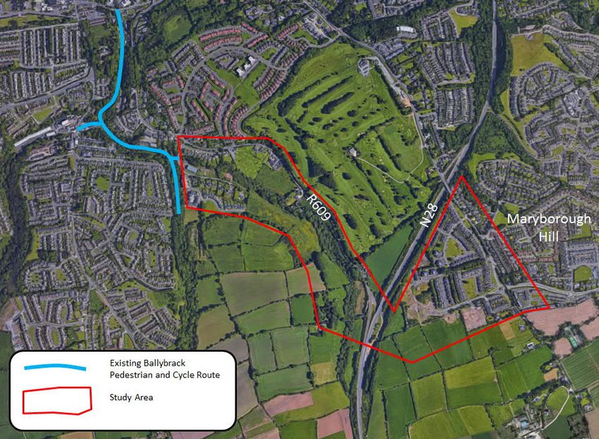
Ballybrack Valley Pedestrian and Cycle Route, Phase 4
Preliminary Design Report

Table of Contents

1.   Introduction.............................................................................................................................. 4
     1.1 Purpose of Report.......................................................................................................... 4
     1.2 Study Area ..................................................................................................................... 4
2.   Constraints .............................................................................................................................. 5
     2.1 Environmental ................................................................................................................ 5
     2.2 Watercourses................................................................................................................. 5
     2.3 Flooding......................................................................................................................... 5
     2.4 Topographical Constraints.............................................................................................. 5
     2.5 Land Use ....................................................................................................................... 6
     2.6 Existing Structures ......................................................................................................... 7
     2.7 Area Development Plan ................................................................................................. 7
     2.7.1 General Objectives ........................................................................................................ 7
     2.7.2 Residential Objectives:................................................................................................... 8
     2.7.3 Cork Cycle Network Plan ............................................................................................... 8
     2.8 Public Utilities ............................................................................................................... 11
     2.8.1 Irish Water .................................................................................................................... 11
     2.8.2 Other Utilities ................................................................................................................ 11
     2.9 Other Proposals in the Area .......................................................................................... 11
     2.9.1 Zoned Lands – Local Area Plan (SE-R-06) .................................................................... 11
     2.9.2 M28 Cork to Ringaskiddy Motorway ............................................................................. 12
     2.9.3 Maryborough Ridge Residential Development .............................................................. 12
3.   Existing Ballybrack Pedestrian and Cycle Path....................................................................... 13
     3.1 Benefits of Existing Pedestrian and Cycle Path ............................................................ 13
4.   Route Options........................................................................................................................ 14
     4.1 Option 1 ....................................................................................................................... 14
     4.2 Option 2 ....................................................................................................................... 14
     4.3 Option 3 ....................................................................................................................... 15
     4.4 Objectives.................................................................................................................... 15
5.   Assessment Methodology ...................................................................................................... 16
     5.1 Introduction .................................................................................................................. 16
     5.2 Scheme Options Summary Table ................................................................................. 18
6.   Analysis ................................................................................................................................. 19
7.   Proposed Design ................................................................................................................... 21
     7.1 Design Route Overview ............................................................................................... 21
     7.1.1 Section1: Berkley Estate .............................................................................................. 21
     7.1.2 Section 2: Zoned Land SE-R-06 ................................................................................... 22
     7.1.3 Section 3: R609/ N28 Junction ..................................................................................... 23
     7.1.4 Section 4: Maryborough Ridge to L6477....................................................................... 24
     7.2 Post M28 Design ......................................................................................................... 25
     7.3 Proposed Cross Section .............................................................................................. 26
     7.4 Connectivity ................................................................................................................. 26
8.   Conclusion............................................................................................................................. 27
     8.1 Benefits of the New Pedestrian and Cycle Path............................................................ 28
Appendix A – Drawings Package ..................................................................................................... 29
Appendix B – AA Screening ............................................................................................................. 30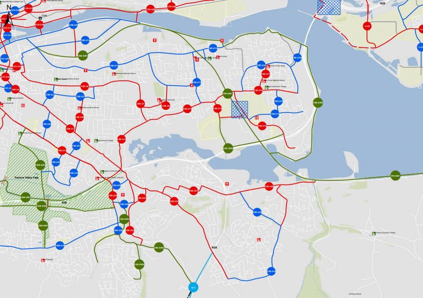
Ballybrack Valley Pedestrian and Cycle Route, Phase 4
Preliminary Design Report
1. Introduction
Cork County Council commissioned AECOM for a route options assessment and the preliminary
design of Ballybrack Valley Pedestrian and Cycle Route, Phase 4.
The purpose of the extension is to connect the existing Ballybrack Pedestrian and Cycle Path with
Maryborough Hill and a new proposed residential development on the R609 Carrigaline Road. The
long term objective is to provide a cycle link between Carrigaline and the South Environs with the City
Centre.
1.1 Purpose of Report
The purpose of the report is to consider route options and to outline the design approach for the
proposed Ballybrack Pedestrian and Cycle Route Phase 4.
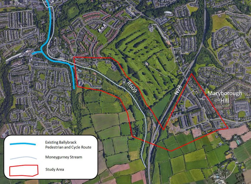
1.2 Study Area
The study area runs from the existing Ballybrack Pedestrian and Cycle Path at the estate road serving
Berkley Estate at the Cork County Council pump house and extends south-eastwards towards the
R609/N28 junction. From here it continues further east to link to Maryborough Hill via Maryborough
Ridge. Figure 1 below highlights the study area for the scheme.
Figure 1.1: Study Area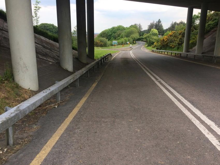
Ballybrack Valley Pedestrian and Cycle Route, Phase 4
Preliminary Design Report
2. Constraints
2.1 Environmental
A separate Appropriate Assessment (AA) Screening report has been produced to inform CCC in
relation to Screening for AA required under the legislation. This is included within Appendix B.
2.2 Watercourses
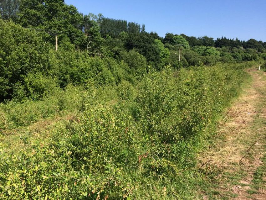
The Moneygurney Stream runs through the study area, it acts as a constraint on the design as
crossings would require additional more costly infrastructure.
Figure 2.1: Watercourse through Study Area
2.3 Flooding
An analysis of the Office of Public Works (OPW) flood hazard maps on the OPW website has been
undertaken to identify the history of flooding in vicinity of the proposed scheme. The website indicates
that there is no history of flooding within the study area.
2.4 Topographical Constraints
A desktop review of the available topographical survey and a site visit indicate that topography will act
as a constraint on the design. A natural valley runs through the centre of the study area which passes
through the proposed residential development to the south west of the R609.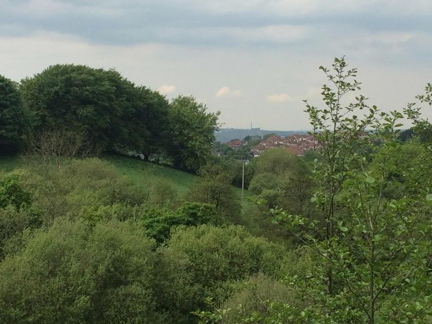
Ballybrack Valley Pedestrian and Cycle Route, Phase 4
Preliminary Design Report

                                                   Figure 2.2: Natural Valley

2.5          Land Use
The proposed study area comprises a greenfield site between two suburban housing estates. Tie in
details at either end of the proposed cycle and pedestrian route will be designed following a review on
the existing land use at either end of the route in the residential areas.

                                                  Figure 2.3: Greenfield Site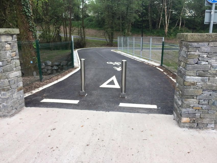
Ballybrack Valley Pedestrian and Cycle Route, Phase 4
Preliminary Design Report

2.6          Existing Structures
The R609 Carrigaline Road travels under the N28, within our proposed study area, before merging
with the N28 further to the south of the junction.

The under bridge junction acts as a constraint for the proposed design as the pedestrian and cycle
route may cross the N28 in close proximity to the bridge/junction.

                                                Figure 2.4: N28 Under Bridge

2.7          Area Development Plan
The proposed scheme lies in the Ballincollig Carrigaline Municipal District. The Ballincollig Carrigaline
Municipal District Local Area Plan (2017) was examined to determine the objectives and policies that
may have an impact on the proposed scheme. Highlighted below are the relevant objectives within
the local area plan that should be considered.

2.7.1        General Objectives
SE-GO-07 – Walking and Cycling:

A network of designated walking and cycling routes shall be established to provide safe, convenient
and pleasant routes between the town’s main residential areas, schools and the town centre in line
with the Metropolitan Cycling Strategy.

The proposed cycle and pedestrian route will comply with this objective within the development plan.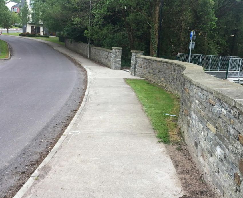
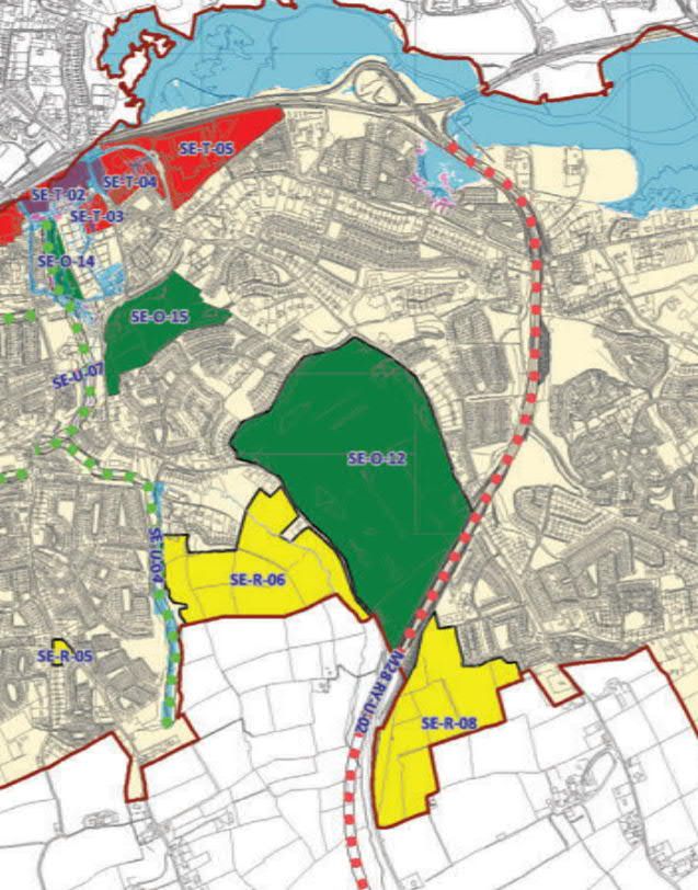
Ballybrack Valley Pedestrian and Cycle Route, Phase 4
Preliminary Design Report

2.7.2        Residential Objectives:
SE-R-06:

The proposed study area for the pedestrian and cyclist route will travel through the 21.1 Ha of land
zoned for Medium A density residential development.

The development plan highlights the requirement for a cycleway as part of the residential
development and retention of existing trees and hedgerows within the overall development of the site.

SE-R-08:

The proposed cyclist and pedestrian route will join with the 16.8 Ha land zoned for Medium A density
residential development.

RY-U-02:

The M-28 Cork to Ringaskiddy Motorway scheme is proposed to replace the existing N-28. This
scheme will need to be considered as part of the design process as it passes through the proposed
study area for the cyclist and pedestrian track.

2.7.3        Cork Cycle Network Plan
Figure 2.5 and 2.6 below are extracts from the Cork Cycle Network Plan for Cork City Southeast &
Environs and Cork Inter-Urban Route Network. Ballybrack Valley Greenway is identified as future
route, GSE-GW4 - Ballybrack Valley Greenway. The proposed Greenway connects other primary,
secondary and interurban cycle network facilities such as CSE-U26 - Church Road, CSE-U29 -
Donnybrook Hill, CSE-U23 - Carrigaline Road, Douglas Street East and IU-3 - N28 and R611.

Within the wider context, a series of greenways have been developed within Tramore Valley Park
CSW-GW1 Passage West Greenway extension/Monahan Road and CSW-GW1 Willow Park to
South Douglas Road which provides connectivity to Cork City. CSW-GW6 Kinsale Road
Roundabout to Alden is being developed by Cork County Council.
Ballybrack Valley Pedestrian and Cycle Route, Phase 4
Preliminary Design Report

                                                                                      Ballybrack Phase 4

                                                        Figure 2.5: Cork Cycle Network Plan, U4 - Cork City Southeast & Environs

                                                                                                                                   AECOM
                                                                                                                                       9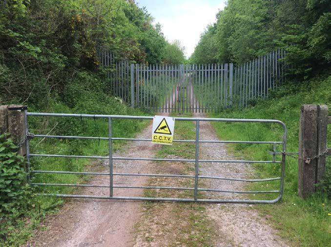
Ballybrack Valley Pedestrian and Cycle Route, Phase 4
Preliminary Design Report

                                                                 Ballybrack Phase 4

                                                        Figure 2.6: Cork Cycle Network Plan, Cork Inter-Urban Route Network

                                                                                                                              AECOM
                                                                                                                                  10
Ballybrack Valley Pedestrian and Cycle Route, Phase 4
Preliminary Design Report
2.8 Public Utilities
2.8.1 Irish Water
A 1.2m Irish Water main runs through the study area, it acts as a constraint on the design as it is the
main water source for the region. A 15m ‘Wayleave’ is in place either side of the water main.
2.8.2 Other Utilities
Utility companies will be contacted during the detailed design phase to determine their assets in the
region. It is envisaged that other public utilities may act as a constraint on the design stage of the
project.
2.9 Other Proposals in the Area
2.9.1 Zoned Lands – Local Area Plan (SE-R-06)
The Ballincollig Carrigaline Municipal District Local Area Plan identifies an area of zoned land that the
proposed Greenway intersects, the zoning includes:
· Medium A density residential development to cater for a variety of house types and sizes.
· 3 Ha. of additional open space over and above what is normally required in housing areas. This
open space should include a fully landscaped and useable public park.
· Retain the existing trees and hedgerows within the overall development of the site.
· A site for a primary school that could be accessed from the R609 and developed by the
Department of Education in the short term.
· The timing and provision of appropriate drinking water and waste water disposal services for the
development including where necessary the upgrading of off-site infrastructure.
· Provision of a cycleway.
· Consideration will need to be given to the provision of a primary school within this site at the
detailed planning application stage.
Figure 2.7 is an extract from the Ballincollig Carrigaline Municipal District Local Area Plan highlighting
the zoned land.Ballybrack Valley Pedestrian and Cycle Route, Phase 4
Preliminary Design Report
Figure 2.7: Ballincollig Carrigaline Municipal District Local Area Plan
2.9.2 M28 Cork to Ringaskiddy Motorway
Cork County Council (CCC), propose to upgrade approximately 12.5km of the N28 National Primary
Route, from the N28/N40 South Ring Toad Bloomfield Interchange to the Port of Cork in Ringaskiddy,
together with consequential and ancillary works. Transport Infrastructure Ireland (TII) is the funding
authority for the project. Phase 4 of the Ballybrack pedestrian and cyclist route is proposed to cross
the existing N28 to connect to Maryborough Hill. The design process will monitor the progress of the
M28 project and ensure it can be compatible with both the existing and the future alignments. Refer to
drawing no: 60578872 – SK-009 for project location.
2.9.3 Maryborough Ridge Residential Development
Permission has been granted for the construction of 200 no. residential units, a crèche and all
associated ancillary development works at Maryborough Ridge on the western boundary of the study
area. The proposed residential development includes for a connection point to the pedestrian and
cycle route. Refer to drawing no: 60578872 – SK-009 for project location.Ballybrack Valley Pedestrian and Cycle Route, Phase 4
Preliminary Design Report
3. Existing Ballybrack Pedestrian and Cycle Path
The existing Ballybrack Pedestrian and Cycle Path is an off road 4m shared use path with public
lighting and CCTV. Cork County Council highlighted the success of the path and are keen to provide a
pedestrian and cycle route to a similar standard for Phase 4 of the path.
Figure 3.1: Existing Path
3.1 Benefits of Existing Pedestrian and Cycle Path
The existing path connects Donnybrook and Maryborough to Douglas Village. The key benefits of the
existing path include:
· Connectivity from key residential developments south of Douglas Village to retail, schools and
employment areas within Douglas Village and Cork City.
· The connectivity is achieved with a high quality of service as the route is off road and safe.
· The route encourages pedestrians and cyclists to utilise the facility as an alternative to driving.
This supports a modal shift away from driving which has a positive impact on the environment.
· Health benefits for people can be attributed to walking and cycling as an alternative to driving.
· The path provides connectivity to other facilities at Tramore Valley Park and as identified in the
Cork Cycle Network Plan, will eventually provide connectivity with larger commuter towns such
as Carrigaline with the Metropolitan Area.Ballybrack Valley Pedestrian and Cycle Route, Phase 4
Preliminary Design Report
4. Route Options
As part of the preliminary design of the proposed cycle and pedestrian path, two routes consisting of
three potential options have been considered to determine the optimum solution. Drawing
60578872_SK001_Route Options contained in Appendix A highlights the proposed options.
4.1 Option 1
Option 1 consists of the following:
· 3m shared use path adjacent to the R609 connecting to Maryborough Ridge in the south and the
existing Ballybrack Pedestrian and Cycle path to the north;
· Existing 2m path on Berkley Road widened to 3m;
· New toucan crossing on the R609;
· New 4m shared use path through the proposed housing estate adjacent to Maryborough Ridge
connecting to the L647.
4.2 Option 2
Option 2 consists of the following:
· 4m offline shared use path connecting Berkeley Road in the north to the R609 in the south;
· New toucan crossing on Berkeley Road;
· New toucan crossings on the R609;
· New 4m shared use path through the proposed housing estate adjacent to Maryborough Ridge
connecting to the L647.Ballybrack Valley Pedestrian and Cycle Route, Phase 4
Preliminary Design Report
4.3 Option 3
Option 3 consists of the following:
· 3m segregated path adjacent to the R609 connecting to Maryborough Ridge in the south and the
existing Ballybrack Pedestrian and Cycle path to the north;
· Existing pedestrian footway along R609 to be extended to the junction with the N28;
· Existing 2m path on Berkley Road widened to 3m;
· New toucan crossing on the R609;
· New 4m shared use path through the proposed housing estate adjacent to Maryborough Ridge
connecting to the L647.
4.4 Objectives
The design objectives for the scheme include the following:
1. To provide a link between the existing Ballybrack Valley Pedestrian and Cycle Route and
Maryborough Ridge, consistent with the quality of the previous phases of the route.
2. To provide a primarily recreational facility but one that can also allow for commuting and school
trips.
3. To connect with key nodes in the area, existing/new housing developments and schools.
4. To create a high quality environment that can promote tourist, recreational and leisure uses in the
study area.Ballybrack Valley Pedestrian and Cycle Route, Phase 4
Preliminary Design Report
5. Assessment Methodology
5.1 Introduction
The options assessment methodology was based on community impacts, delivery risks and the
principles of sustainable safety (National Cycle Manual), which account for the DTTAS Common
Appraisal Framework (CAF) Multi-Criteria Analysis (MCA). The diagram below shows how the
proposed criteria match up with the DTTAS CAF MCA.
Figure 5.1: Proposed Criteria vs DTTAS MCA
The proposed seven criteria above can be grouped into the following categories:
1. Design context;
2. Community context;
3. Delivery context.
The proposed categories and their respective criteria are presented in Table 5.1.Ballybrack Valley Pedestrian and Cycle Route, Phase 4
Preliminary Design Report
Categories Criteria Considerations
The objective for this scheme, in terms of functionality,
is to enhance the place functionality, while still providing
safe movement through the area for all road users.
· Attractiveness of space/contribution to urban design;
Functionality
· Pedestrians and cycle experience;
· Quality of service for cyclists;
· Reducing traffic volumes and speed.
Where any space in the scheme is shared by users of
different modes, the design should naturally encourage
homogeneity of speed, mass and direction as much as
Homogeneity possible.
· Minimising relative speed of users;
· Number of collision points.
The design should ensure that confusion is minimised,
and all road users are clear on how to proceed through
the area.
Design Context
Legibility · Clarity of how to use space from all users;
· Minimise conflicts between cyclist/pedestrian/traffic
on links and crossings;
· Clarity of connection with existing cycle tracks.
The layout of the chosen design should be such that the
severity of potential collisions are minimised.
· Proximity of cyclist/pedestrian to general traffic;
Forgiveness · Street furniture position;
· Lighting;
· Cross falls;
· Evasion room.
The space will naturally draw a large variety of users
who will expect to use the space safely.
Self-Awareness · Accommodation of children/less experienced users;
· Designed for peak and of peak use.
· Property access;
· Loading;
Community Context Local Impact
· Parking;
· Change to traffic arrangement and impact.
Budget and · Construction Costs;
Delivery Context
Programme Risks · Maintenance Costs.
Table 5.1: Proposed CriteriaBallybrack Valley Pedestrian and Cycle Route, Phase 4
Preliminary Design Report
5.2 Scheme Options Summary Table
An options summary table has been prepared which summarises the appraisal of each option under
each of the assessment criterion.
For each individual assessment criterion considered, routes have been relatively compared against
each other based on a five point scale, ranging from having significant advantages to having
significant disadvantages over other scheme options.
For illustrative purposes, this five point scale is colour coded as presented in Table 5.2 with
advantageous options graded to ‘dark green’ and disadvantageous options graded to ‘dark red’.
Colour Description
Significant advantages over the other options
Some advantages over other options
Neutral compared to other options
Some disadvantages compared to other options
Significant disadvantages compared to other options
Table 5.2: Design Options Colour Coded Ranking Scale
A qualitative appraisal of and conclusions from, the options assessment is then provided, highlighting
the key issues considered in determining the recommended option.
All criteria are considered in undertaking the assessment and a lower ranking on one criterion, for
example, does not necessarily mean that the option is not suitable.Ballybrack Valley Pedestrian and Cycle Route, Phase 4
Preliminary Design Report
6. Analysis
Criteria Option 1 Option 2 Option 3
The shared space would The shared space would The segregated space
enhance the attractiveness of enhance the attractiveness of would enhance the
scheme area. However, scheme area. However, attractiveness of scheme
mixing pedestrians with mixing pedestrians with area.
cyclists would reduce the cyclists would reduce the
Functionality
quality of service for cyclists. quality of service for cyclists. A 3m segregated cycle path
would be provided parallel to
A 3m shared use path would A 4m shared use path would a 2m footway.
be provided. be provided.
The shared space would The shared pedestrian/cyclist Segregating cyclists and
encourage reduced cyclist facility would encourage pedestrian through the R609
speeds through the scheme reduced cyclist speeds section of the route would
area. However, it would through the scheme area. reduce the number of
increase the likelihood of However, it would increase collision points between
potential pedestrian/cyclist the likelihood of pedestrians and cyclists.
Homogeneity conflicts. pedestrian/cyclist conflicts.
The width of the facility
provided increases its
advantage over Option 1.
The shared space would not The shared pedestrian/cyclist The segregated cycle track
provide a consistent link for facility would provide a would provide a consistent
cyclists through the scheme consistent link for cyclists link for cyclists through the
area i.e. the previous phases through the scheme area i.e. scheme area.
provide an offline path. the previous phases provide In regard to pedestrian and
an offline path. cyclist interaction with traffic,
In regard to pedestrian and Option 3 would have more
Legibility traffic interaction, Option 1 In regard to pedestrian and conflict points with traffic due
would have higher interaction traffic interaction, Option 2 to the number of access
due to the location of the would have less interaction along the R609.
path. due to the offline nature of
the path.
Lighting would be used in all Lighting would be used in all Lighting would be used in all
options to enhance visibility options to enhance visibility options to enhance visibility
within the scheme area as within the scheme area as within the scheme area as
well as to indicate conflict well as to indicate conflict well as to indicate conflict
areas. areas. areas.
Similarly, all options would Similarly, all options would Similarly, all options would
use street furniture, tactile use street furniture, tactile use street furniture, tactile
paving and trees/planters to paving and trees/planters to paving and trees/planters to
Forgivingness define specific user paths define specific user paths define specific user paths
e.g. pedestrian routes, cycle e.g. pedestrian routes, cycle e.g. pedestrian routes, cycle
route, vehicular routes. route, vehicular routes. route, vehicular routes.
The severity of potential The severity of potential
collisions is higher for Option collisions is higher for
1 due to the proximity of the Option 1 but lower than
carriageway. Option 2 due to the
proximity of the carriageway.Ballybrack Valley Pedestrian and Cycle Route, Phase 4
Preliminary Design Report
The shared space would be The shared pedestrian/cyclist The segregated cycle space
less suitable for facility would be suitable for would be more suitable for
inexperienced cyclists during inexperienced cyclists during inexperienced cyclists
times of high pedestrian times of high pedestrian during times of high
activity. activity due to the width and pedestrian as cyclists would
offline nature of the path. be segregated from all other
Commuter cyclists would road users for 1km of the
Self-Awareness
likely use the carriageway Commuter cyclists would proposed 2km route.
rather than a shared use likely mix with the
path adjacent to the pedestrians due to the width
carriageway. of the facility.
The proposed design would The proposed design would The proposed design would
enhance the local area as it enhance the local area as it enhance the local area as it
would provide a walking and would provide an offline would provide a walking and
cycling facility to connect walking and cycling facility to cycling facility to connect
Maryborough Ridge connect Maryborough Ridge Maryborough Ridge
Development with Douglas Development with Douglas Development with Douglas
and Cork City. and Cork City. and Cork City.
Local Impact
However, the impact to the However, the impact to the
property entrances would be property entrances would be
significant and land significant and land
acquisition would be acquisition would be
required. required. Land acquisition
would be greater in Option 3
than Option 1.
Option 1 would require land Option 2 would represent Option 3 would require land
acquisition along the R609. It good value for money as the acquisition along the R609.
would represent poor value majority of the land required It would represent worse
for money as the land is contained within value for money than the
required to construct the Maryborough Ridge other options as the land
route would be more Development; a planning required to construct the
Budget and expensive. It would also constraint requires the route would be more
Programme Risks require more structures to be construction of a path for this expensive. It would also
constructed or replaced development and could be require more structures to
along the route to facilitate constructed with developer be constructed or replaced
the pedestrian and cycle contributions. along the route to facilitate
route. the pedestrian and cycle
route.
Option 2 is considered the more favourable option; the off-road route follows the Moneygurney
Stream through a natural valley and continues the quality of facility provided in the previous phase of
the pedestrian and cycle route. Section 7 of this report describes the route in greater detail.Ballybrack Valley Pedestrian and Cycle Route, Phase 4
Preliminary Design Report
7. Proposed Design
7.1 Design Route Overview
The proposed route of the Ballybrack Valley Cyclist and Pedestrian Route Phase 4 connects to the
existing Ballybrack Valley Phase 2, at Berkley Housing estate, to the proposed new roundabout on the
L6477 adjacent to Maryborough Ridge. Refer to drawings SK-001 to SK012 in Appendix A for further
details.
The proposed route travels through the Zoned Land SE-R-06 adjacent to the R609, under the existing
N28 and through a proposed residential development at Maryborough Ridge before ending at the new
proposed roundabout on the L6477.
7.1.1 Section1: Berkley Estate
The Existing Ballybrack Valley Phase 2 scheme connects to Berkley Estate. A toucan crossing is
proposed at this location to connect Phase 2 to Phase 4 of the scheme. As the entrance is located on
a slight bend, the proposed toucan crossing is located to the north of the existing entrance to Phase 2
in order to achieve the required visibility on approach to the pedestrian crossing.
Figure 7.1 – Entrance to Ballybrack Valley Phase 2
The proposed route will travel through the Irish Water Pumping Station to the south east of the toucan
crossing. A 4m shared use path will be provided through the pumping station. A new pedestrian and
cyclist entrance will need to be provided as well as internal fencing to secure the pumping station site.Ballybrack Valley Pedestrian and Cycle Route, Phase 4
Preliminary Design Report
Figure 7.2 – Entrance to Irish Water Pumping Station
7.1.2 Section 2: Zoned Land SE-R-06
From the western boundary of the Irish Water Pumping Station the proposed route will proceed
through the Zoned Land SE-R-06 following the route of the Moneygurney Stream. Figure 7.3 below
shows the undeveloped land available for the proposed route.
Figure 7.3 – Proposed Route Through Zoned Land SE-R-06Ballybrack Valley Pedestrian and Cycle Route, Phase 4
Preliminary Design Report
7.1.3 Section 3: R609/ N28 Junction
From the south east boundary of the prosed development the route progresses off road to an existing
access path which crosses the Moneygurney Stream and joins the R609 at the slip road with the N25.
The route proposes to utilise this existing track while maintaining vehicular access to the proposed
farm house which the track currently serves.
A toucan crossing will be provided where the access track meets the R609. The toucan crossing will
enable pedestrians and cyclists to safely cross the N28 slip road.
Figure 7.4 – Access Track, R609 and N28 slip road junction where toucan crossing is to be
provided
The toucan crossing then connects to a redundant traffic lane which travels underneath the N28. SK-
012, Cross Section C-C highlights the proposed design along the redundant traffic lane with a
proposed 500mm separation strip.
A toucan crossing is provided on the south eastern side of the N28 underpass to connect the
proposed route to an existing access track which runs adjacent to the N28 to Maryborough Ridge.Ballybrack Valley Pedestrian and Cycle Route, Phase 4
Preliminary Design Report
Figure 7.5 – Redundant traffic lane underneath the N28
Figure 7.6 – Access Track connecting R609/N28 junction to Maryborough Ridge
7.1.4 Section 4: Maryborough Ridge to L6477
The Maryborough Ridge residential development was partly developed circa 2007. It is now subject to
a new planning application which looks to develop the remainder of site.Ballybrack Valley Pedestrian and Cycle Route, Phase 4
Preliminary Design Report
From the existing access track, the proposed route follows the proposed main access road through
the housing development. This proposed road is partly constructed and will be completed as part of
the new planning application for the site.
The proposed design for the route will widen the existing 2m footpaths on the north side of the road to
4m shared use pedestrian and cycle paths along the route indicated on SK-006, SK-007 and SK-008.
Figure 7.6 below shows the existing 2m footways to be widened. As part of the widening, the existing
lighting columns will require relocating.
A number of crossing points have been identified along this residential route. Raised uncontrolled
crossings are proposed for these locations to maximise the safety for pedestrians and cyclists at
these locations. The proposed scheme terminates at the proposed roundabout on the L6477 which is
to be constructed as part of the Maryborough Ridge development.
Figure 7.7 – Maryborough Ridge Footways
7.2 Post M28 Design
The N28/R609 junction is to be upgraded as part of the M28 upgrade scheme which is currently in the
planning process. The route of the Ballybrack Valley Phase 4 has been designed to integrate into the
future M28 scheme.
The route connects to pedestrian and cycle route proposed as part of the M28 upgrades, the route is
located to the west of the existing R609/N28 junction. The M28 cycle and pedestrian facility will route
the scheme across the new M28. At this location a new pedestrian and cycle path will need to beBallybrack Valley Pedestrian and Cycle Route, Phase 4
Preliminary Design Report
constructed to Maryborough Ridge as the existing path connecting to Maryborough Ridge will be
removed as part of the M28 construction.
SK-009 indicates the proposed route of Ballybrack Valley Phase 4 post the M28 construction.
7.3 Proposed Cross Section
Typical cross sections for the scheme are highlighted in drawings SK-011 and SK-012, located in
Appendix A. Where possible a 4m wide pedestrian and cycle shared path is provided similar to the
cross section provided in Ballybrack Valley Phase 2.
Figure 7.8 – Existing Ballybrack Scheme
7.4 Connectivity
Connectivity with residential developments and other points of interest in the study area was identified
as a key design consideration for the preliminary design. The Ballybrack Phase 4 route passes
through Zoned Land SE-R-06 as highlighted in paragraph 2.9.1. Two access ramps have been
designed as part of the route through the zoned land to allow access to the greenway. A further
access ramp was designed to connect to a potential site for the proposed school site with access from
the R609 as per the Zoned Land SE-R-06 requirements.
The proposed route also connects to Maryborough Ridge which currently consists of an existing 362
residential units with a further 219 units in the process of being developed or in the planning system.
This proposed route would significantly improve the pedestrian and cyclist access to development.
By continuing the Ballybrack Phase 4 route through to the L6477 it provides the opportunity for
pedestrians and cyclists from Maryborough Hill and Broadale to connect to the pedestrian and cycle
scheme.Ballybrack Valley Pedestrian and Cycle Route, Phase 4
Preliminary Design Report
The M28 has received planning permission which will enable an interurban cycle route to be
developed along the N28 to be developed as per the Cork Cycle Network Plan. Ballybrack Valley
Phase 4 will integrate with this interurban cycle route.
8. Conclusion
A summary of the analysis results is presented in Table 5.1, Table 5.2 and Table 5.3 below.
Table 8.1: Analysis Summary for each Criteria
Categories Criteria Option 1 Option 2 Option 3
Functionality
Homogeneity
Design
context Legibility
Forgivingness
Self-Awareness
Community
Local Impact
context
Delivery Budget and
context Programme Risks
Table 8.2: Analysis summary for each category
Categories Option 1 Option 2 Option 3
Design context
(average)
Community context
Delivery context
Table 8.3: Overall average scores
Categories Option 1 Option 2 Option 3
Overall ranking
Based upon the analysis produced, Option 2 has significant advantages over Options 1 and 3. In
conclusion, it is recommended that the Option 2 is the preferred route and should progress to the
detailed design stage.Ballybrack Valley Pedestrian and Cycle Route, Phase 4
Preliminary Design Report
8.1 Benefits of the New Pedestrian and Cycle Path
As highlighted in paragraph 3.1 the key benefits of the existing pedestrian and cycle path from
Donnybrook and Maryborough to Douglas Village include the following:
· Connectivity from key residential developments south of Douglas Village to retail, schools and
employment areas within Douglas Village and Cork City.
· The connectivity is achieved with a high quality of service as the route is off road and safe.
· The route encourages pedestrians and cyclists to utilise the facility as an alternative to driving.
This supports a modal shift away from driving which has a positive impact on the environment.
· Health benefits for people can be attributed to walking and cycling as an alternative to driving.
· The path provides connectivity to other facilities at Tramore Valley Park and as identified in the
Cork Cycle Network Plan, will eventually provide connectivity with larger commuter towns such
as Carrigaline with the Metropolitan Area.
Ballybrack Valley Phase 4 extends the benefits of the existing pedestrian and cycle path to a wider
area to include residential developments such as Maryborough Hill, Maryborough Ridge and
Broadale, it increases the connectivity from these areas to Douglas Village and Cork City.Ballybrack Valley Pedestrian and Cycle Route, Phase 4 Preliminary Design Report Appendix A – Drawings Package
Ballybrack Valley Pedestrian and Cycle Route, Phase 4
Preliminary Design Report

Appendix B – AA Screening
Ballybrack Valley Pedestrian and Cycle Route, Phase 4
Preliminary Design Report

aecom.com
You can also read