Bass Highway - Latrobe to Deloraine - Tasmanian Government 2012 Transport Submission to Infrastructure Australia
←
→
Page content transcription
If your browser does not render page correctly, please read the page content below
Tasmanian Government
     2012 Transport Submission to
     Infrastructure Australia
     Bass Highway –
     Latrobe to Deloraine

                                         August 2012

Department of Infrastructure, Energy and Resources
Proposal Summary
Initiative Name: Burnie to Hobart Freight Corridor: Bass Highway Forward
Planning – Latrobe to Deloraine
Location (State/Region(or City)/ Locality): Latrobe to Deloraine, North West Tasmania
Name of Proponent Entity: Tasmanian Department of Infrastructure, Energy and Resources
Contact (Name, Position, phone/e-mail): David Spence, General Manager Infrastructure Strategy
Department of Infrastructure, Energy and Resources
Tel: (03) 6233 2089
Email: david.spence@dier.tas.gov.au
Executive summary
The Bass Highway is a key facilitator of Tasmania’s economic growth, carrying over $3.8 billion of freight in
2008/09. The Highway connects Burnie and Devonport Ports – Tasmania’s two highest volume ports – major
agricultural, manufacturing and industrial areas, and is a key part of the corridor connecting the southern
region to the northern ports.
The Bass Highway, east of Burnie, carries the highest freight volumes on Tasmania’s transport network. Over
the long term, this section of the Highway is projected to nearly double its freight volumes by 2029 to between
6.6 and 8.6 million tonnes. This growth will see the Highway remain as the highest volume land transport
freight link in Tasmania.
The Highway is part of the National Network, and has seen significant investment over the past two decades.
Most adjacent towns have now been bypassed, with extensive sections of high standard dual carriageway and
grade-separated interchanges. The majority of the Highway is at National Network standard, however the
section between Latrobe and Deloraine (east of Devonport) requires major upgrade and is the key remaining
section requiring investment. This section is a single carriageway rural highway, compared to adjacent dual
carriageway sections, and is deficient in terms of alignment, lane and shoulder widths for both existing and
future heavy vehicle configurations. Other issues include a low level of service (Level of Service D to E on
sections east of Devonport); high crash risk and density; and multiple direct property accesses.
Upgrade of the Bass Highway between Port Sorell Main Road and Deloraine was identified as a priority in the
Tasmanian AusLink Corridor Strategy 2007 due to a number of deficiencies: low level of service, high crash
risk and density, multiple direct accesses, and narrow lanes and shoulder widths.
The Tasmanian Government is seeking planning funding under National Building 2 to analyse efficiency and
safety issues on the Highway; investigate and develop corridor options, including preliminary designs for key
sections; review applicable regulatory requirements (planning, environmental, heritage); and undertake initial
stakeholder engagement. The outcome would be a long-term, prioritised plan for upgrade of the corridor that
supports improved freight efficiency and safety.
The section of the Highway passing through Latrobe is an area of significant constraint from a freight transport
and safety perspective. Planning for the Highway through Latrobe, including the appropriateness of a bypass
at this location, would form a key focus of future planning.
Is this a new submission? Part of larger submission to IA in 2008
Estimated cost of problems? To be determined as part of the planning phase
Estimated Capital Cost of Initiative by $5 million for planning
Proponent ($M, nominal, undiscounted):
1Commonwealth contribution sought by $5 million for planning
Proponent ($M, nominal, undiscounted):
Other funding (source/amount/cash flow) To be determined in development phase
($M, nominal, undiscounted):
BCR by Proponent excluding Wider To be determined as part of the planning phase
Economic Benefits
Estimated program Planning would commence in 2014/15 and be completed in
2015/16.
2Goal Definition
The Bass Highway is a key facilitator of Tasmania’s economic growth, carrying the highest
freight tonnages of any section of Tasmania’s land transport network, at an estimated value
of over $3.8 billion in 2008/09. The Highway connects Tasmania’s two highest volume sea
ports, major agricultural, processing and industrial areas, and is a key inter-regional link for
freight and passengers.
Reflecting the strategic function of the Highway, the Tasmanian Government’s objective in
planning and managing this section of the Burnie to Hobart Freight Corridor is to:
• provide an efficient and safe road network, that supports improved productivity and
efficiency between the northern export ports, freight generating areas and distribution
centres, across regions; and
• deliver ongoing improvements to support freight productivity gains over the long term.
The Bass Highway Forward Planning – Latrobe to Deloraine initiative will develop an
evidence-based, prioritised corridor plan that addresses current and future transport
demands, consistent with overall corridor objectives.
Positive contribution to Infrastructure Australia’s strategic priorities
The project aligns well with Infrastructure Australia’s strategic objectives, including:
• Improving the efficiency of connections to major road and rail freight corridors
to facilitate domestic trade and international exports – the Bass Highway is
Tasmania’s highest volume freight corridor, and the major National Network link to
Tasmania’s highest volume ports at Burnie and Devonport. The Highway moves an
average of 3.6 million tonnes per year, and connects to major ports, agricultural and
processing centres, and facilitates freight connectivity across regions. Addressing
constraints on this section will deliver a consistent, high standard freight corridor
along the Bass Highway from Burnie to Launceston.
• Achieving better utilisation of existing infrastructure – Significant investment has
been made in the Bass Highway, reflecting its strategic function and high traffic
volumes. Addressing existing deficiencies on the section between Latrobe and
Deloraine will maximise outcomes from the investment already made in the corridor,
by delivering a consistent, high standard and safe freight corridor capable of meeting
forecast volumes and advances in freight vehicle productivity.
Alignment with State/regional strategic plans
The strategic importance of the Bass Highway is identified in Tasmania’s strategic transport
planning frameworks.
Tasmanian Infrastructure Strategy (www.infrastructure.tas.gov.au)
Targeted improvements to key freight supply chains are one of the key reforms listed in the
Tasmanian Infrastructure Strategy (TIS), with upgrades for the Bass Highway, Deloraine and
East Devonport/Port Sorell Main Road a priority in the first 3-5 years of the TIS.
The TIS, released in 2010, is Tasmania’s integrated long-term strategy to guide future
infrastructure projects and decision making. The TIS identifies the State’s heavy economic
3reliance on the ability of its transport system to move freight from producers to processors
and on to markets – within Tasmania, nationally and internationally. The project aligns with
the TIS stream for the integrated, efficient and safe movement of freight.
Tasmanian AusLink Corridor Strategy 2007
The Bass Highway between Port Sorell Main Road and Deloraine is identified as a priority
project in the National Network due to its significant deficiencies: low level of service, high
crash risk and density, multiple direct accesses, and narrow lanes and shoulder widths. The
growth in traffic volumes on road sections with a high casualty crash rate including those
with a low level of freight efficiency such as around Latrobe and Burnie, was assessed as
one of the seven major challenges for Tasmania’s National Network.
The Tasmanian AusLink Corridor Strategy 2007 noted that the efficiency and productivity of
the network was affected by older sections of highway with direct access points, which affect
safety and efficiency. The Bass Highway between Latrobe and Deloraine is listed as an area
where this is a particular issue.
The Tasmanian Government has already upgraded deficient sections on the Highway
between Deloraine and Launceston and between Devonport and Burnie, identified as
deficient within the Corridor Strategy.
Draft Tasmanian Transport Policy and Draft Tasmanian Freight Strategy
Strategic fit with the State’s draft Transport Policy and Draft Freight Strategy is addressed in
the Tasmanian Government Submission Overview.
Infrastructure Delivery Imperative
The Tasmanian Government has made significant investment in high volume sections of the
Bass Highway between Burnie and Devonport and Devonport and Launceston to bring these
sections up to National Network standard.
The Bass Highway between Latrobe and Deloraine is the key remaining section requiring
upgrade. It is deficient in terms of alignment, lane and shoulder widths for both existing and
future heavy vehicle configurations. Other issues include a low level of service (Level of
Service D to E on sections east of Devonport); high crash risk and density; and multiple
direct property accesses.
The Tasmanian Government is seeking planning funding now to support detailed
investigation of issues and options, supporting future funding opportunities.
Problem identification, assessment and analysis
The Burnie to Hobart freight corridor is Tasmania’s most significant freight corridor by
tonnage, traffic volumes, and strategic land use connections. This corridor includes the Bass
Highway, Midland Highway, Illawarra Main Road, Brooker Highway, and the north-south rail
line, connecting major ports, the Brighton Transport Hub and key industrial and
manufacturing centres in all three regions. It is Tasmania’s key corridor for the movement of
containerised freight.
The Bass Highway, east of Burnie, carries the highest freight volumes on Tasmania’s land
transport network. The Highway is part of the National Network, and has seen significant
investment over the past two decades. Most adjacent towns have now been bypassed, with
extensive sections of high standard dual carriageway and grade-separated interchanges.
4High volumes through Burnie and Devonport ports; reliance by the southern region on the
northern ports for export/import; and the significant agricultural, manufacturing and industrial
activity on the north-west coast, contribute to this high freight activity.
The section of the highway directly adjacent to Burnie Port carried 4.4 million tonnes in
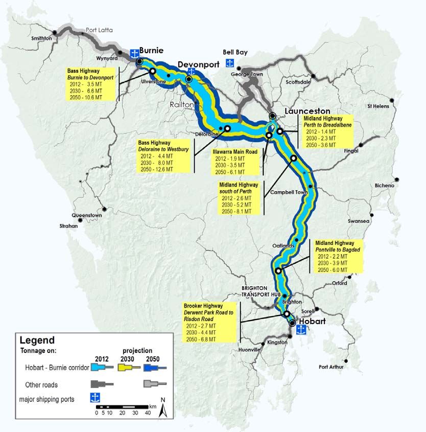
2008/09, with volumes along the Highway remaining consistently high (see Table 1). The
estimated value of this freight in 2008/09 was over $3.8 billion, highlighting the Highway’s
economic importance.
Table 1: Freight volumes, Bass Highway, 2008-09
Freight tonnages are forecast to
Road Link 2008/09 tonnage
double on the Highway to between
(millions tonnes per
6.6 and 8.6 million tonnes by 2029 annum)
(see Map 1). The number of heavy
vehicles is also forecast to double Bass Highway, Edward Street 4.39
over the long-term. This growth Bass Highway, Ulverstone 2.88
will see the Highway remain as the
Bass Highway, Victoria Bridge 3.45
highest volume land transport
freight corridor in Tasmania. Bass Highway, Elizabeth Town 3.31
The majority of the Bass Highway Bass Highway, at Birralee Road junction 3.56
is at National Network standard,
Bass Highway, at Illawarra Road junction 2.70
however the section between
Latrobe and Deloraine (east of Source: DIER Tasmanian Freight Survey 2008/09
Devonport) requires major
upgrade and is the key remaining section requiring investment. This section is a single
carriageway rural highway, compared to adjacent dual carriageway sections. It is deficient in
terms of alignment, lane and shoulder widths for both existing and future heavy vehicle
configurations. Other issues include a low level of service (Level of Service D to E on
sections east of Devonport); high crash risk and density; and multiple direct property
accesses.
Latrobe is an area of significant constraint from a freight productivity and safety perspective.
Areas to be considered include the appropriateness of a bypass through this section, design
standards for future heavy vehicle configurations and the resolution of safety issues.
Planning around Latrobe would form a key part of this study.
The Government is seeking $5m in planning funding under National Building 2 to analyse
efficiency and safety issues on the Highway; investigate and develop corridor options,
including preliminary designs for key sections; review applicable regulatory requirements
(planning, environmental, heritage); and undertake initial stakeholder engagement. The
outcome will be a long-term, prioritised plan for upgrades that supports improved freight
efficiency and safety on this section of the Bass Highway.
Option Generation and Assessment
As noted above, achievement of enhanced freight productivity to meet Tasmania's future
economic development needs is the key goal.
5Use of rail to meet future productivity needs could be seen as an alternative to upgrading
road infrastructure. However, as noted in the transport overview document, rail and road act
in a complementary manner to meet Tasmania's freight needs. Rail has inherent
advantages in the movement of bulk freight and some growth in the intermodal task is
expected. However the majority of the freight task will continue to be moved by road, as the
service characteristics of road are, in most cases, better suited to freight market needs.
Consequently, road network upgrades will continue to be a priority in Tasmania.
Map 1: Current and forecast freight volumes, Burnie to Hobart Freight Corridor
6You can also read