Bay Trails Torbay Local Cycling and Walking Infrastructure Plan (LCWIP) - Post consultation report - Torbay Council
←
→
Page content transcription
If your browser does not render page correctly, please read the page content below
Bay Trails
Torbay Local Cycling and Walking Infrastructure Plan (LCWIP)
Post consultation report
Bay Trails
Torbay Local Cycling and Walking Infrastructure Plan (LCWIP)
Post consultation report

TYPE OF DOCUMENT (VERSION) PUBLICPUBLIC

PROJECT NO. 70072349
OUR REF. NO. PROJECT REF

DATE: MARCH 2021

WSP
1st Floor
Keble House
Southernhay Gardens
Southernhay East
Exeter
Devon

WSP.com
Contents
1. Introduction                                                 1

2. Active travel context                                        2

3. National and local policy context                            3

4. Existing cycling and walking travel patterns                 6

5. Network planning for cycling                                14

6. Network planning for walking                                35

7. Prioritisation and costs                                    39

8. Next steps                                                  41

Appendix A: Key cost assumptions                               43

Torbay Local Cycling and Walking Infrastructure Plan (LCWIP)           PUBLIC
                                                                    MARCH 2021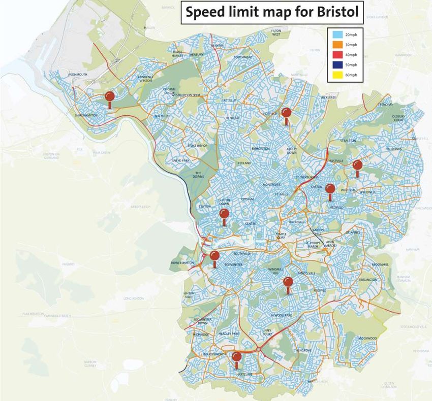
1   Introduction

     Background                                                            The Torbay LCWIP focuses on everyday journeys to work and
                                                                           school, as well as unlocking the potential of more people visiting
     Torbay has a world class tourism offer, with a fantastic marine       the area for recreational cycling and walking.
     setting and internationally important environmental assets,
     recognised by its UNESCO Global Geopark status. Situated in           The government has published guidance on the preparation of
     the South West of England, it is home to strong small businesses,     LCWIPs, setting out the following six stage process:
     one of the nation’s leading fishing ports at Brixham, and an          ▪   Stage 1: Determine the scope – establish the geographical
     increasingly skilled workforce. However, Torbay faces challenges          context and arrangements for governing the plan.
     including health and income deprivation, an aging population, and
     responding to the climate crisis. As with other coastal and retail    ▪   Stage 2: Gathering information – identify existing walking
     centres, Torbay’s town centres are in decline with falling footfall       and cycling patterns and potential new journeys. Review
     and spend.                                                                existing conditions and identify barriers to walking and
                                                                               cycling. Review related policies and programmes.
     Investment in cycling and walking schemes can help address
     these challenges: supporting improved public health through           ▪   Stage 3: Network planning for cycling – identify origin and
     active travel; providing access to centres of employment, learning        destination points and cycle flows. Convert flows into a
     and skills training; cutting carbon emissions; and, helping bring         network of routes and determine the improvements required.
     about a green recovery from the COVID-19 crisis. It can deliver       ▪   Stage 4: Network planning for walking – identify key trip
     public realm improvements, further enhancing the outstanding              generators, core walking zones and routes, audit existing
     built and natural environment of Torbay and contributing to the           provision and determine the improvements required.
     wider tourism offer. With significant national funding available
     and reviews of the Torbay Local Plan and other policy in progress,    ▪   Stage 5: Prioritising improvements – prioritise improvements
     this is an opportune moment to bring forward and integrate cycling        to develop a phased programme for future investment.
     and walking improvements within broader policy.                       ▪   Stage 6: Integration and application – integrate outputs into
                                                                               local planning and transport policies, strategies and plans.
     LCWIP Process
                                                                           The remainder of this document details how the LCWIP has been
     Local Cycling and Walking Infrastructure Plans (LCWIPs) are a         developed and sets out a prioritised programme for its delivery.
     strategic approach to identifying cycling and walking
     improvements required at a local level. They enable a long-term       Public consultation
     approach to developing networks and routes and form a vital part
     of the Government’s strategy to increase the number of trips          A public consultation on this LCWIP was carried out between 3 rd
     made on foot or by cycle. LCWIPs will be instrumental in              February and 14th March 2021. A total of 705 survey responses
     leveraging funding from the Cycle Infrastructure Fund, along with     were received, with key findings including:
     other national and local funding streams. LCWIPs are intended         ▪   The majority of respondents support the LCWIP, with 71.4%
     to:                                                                       in support, 17.4% “don’t know”, and 11.2% not supporting.
     ▪   Plan for cycling and walking using evidence and data on           ▪   Respondents have increased the amount they walk and
         existing and future potential demand;                                 cycle during the covid pandemic began, with 43% stating
     ▪   Target investment where it can have the greatest impact;              they thought these changes would continue.

     ▪   Identify cycling and walking infrastructure improvements in       ▪   85% of respondents would like to see an increase in walking
         readiness for funding bids; and                                       in Torbay, and 71% would like to see an increase in cycling.

     ▪   Plan cycling and walking networks which meet core design          ▪   31 written responses, including from community groups and
         outcomes, meeting the needs of users.                                 local businesses, were raised in relation to the
                                                                               recommendation to explore restricting motor vehicle access
     For Torbay, this process and the resulting outputs will represent         on Victoria Parade. As such, this recommendation has been
     an evidence-based approach to focus future investment over the            changed and focuses on improving conditions in other ways.
     next 10-20 years where the most benefit can be realised.
                                                                           A number of other constructive comments were raised during the
     The geographical extent of this LCWIP is the entire Unitary           public consultation, which have been incorporated in this updated
     Authority of Torbay, encompassing the three main towns of             version of the LCWIP where appropriate. Further detail can be
     Torquay, Paignton, and Brixham.                                       found in the accompanying consultation report.

    Torbay Local Cycling and Walking Infrastructure Plan (LCWIP)                                                                                FOR CONSULTATION
                                                                                                                                                      MARCH 2021
                                                                                                                                                           Page 1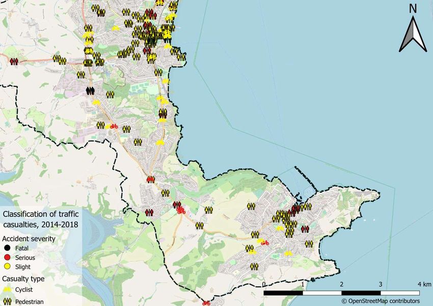
2   Active travel context

    The case for walking and cycling                                                A lack of physical activity is the cause of one in six deaths in the UK, and   visitor bed nights per year and the population increasing from 130,000 to
                                                                                    costs the country an estimated £7.4bn per year. i In Torbay, 61% of adults     over 200,000 in summer months. The English Riviera Destination
    The Department for Transport’s Cycling and Walking Investment Strategy          and 43% of children are overweight or obese, with an annual direct cost        Management Plan aims to increase year-round growth in visitor numbers,
    (CWIS) presents a clear ambition to make walking and cycling the natural        of around £2.5 million to the NHS and around £18m of wider societal            extend the season, and attract new international and UK visitors.
    choice for shorter journeys or as part of a longer journey, including the       costs. 14% of the adult population currently cycle at least twice a monthii
    aim to double cycling activity by 2025. The benefits of achieving this                                                                                         Cycling and walking investment can play a key role in enhancing the
                                                                                    yet by improving active travel networks the LCWIP can increase this level
    outcome would be substantial, supporting public health and wellbeing,                                                                                          tourism offer. It can improve the quality of the urban realm, make it easier
                                                                                    and make cycling a common form of exercise for more people. Torbay
    more vibrant towns and public spaces, and low carbon travel patterns                                                                                           for visitors to travel around the bay, and provide new reasons to visit the
                                                                                    Council are encouraging more people to be active as well as using sport
    becoming commonplace.                                                                                                                                          bay with high quality cycling and walking experiences.
                                                                                    and physical activity to help address health inequalities, contribute
    In February and May 2020 Government announced a £2 billion plan to              positively to the economy and raise the profile of the area.                   Existing travel patterns in Torbay
    boost cycling and walking both during and after the Covid-19 lockdown.          Focussing on inclusive “All Ages and Abilities (AAA)” design and ensuring      Nearly two-thirds of journeys to work by residents in Torbay are by car or
    £1 billion is expected to be spent on building 250 miles of new, high quality   cycling is accessible for all will be important when developing and            van as a driver or passenger (Census 2011), with 15% travelling to work
    cycle routes and safe junctions in towns and cities across England. The         delivering schemes through the LCWIP process.                                  on foot. Just 1% travel to work by bicycle, significantly lower than the
    Department for Transport also announced that dozens of new “Mini-
                                                                                    Improving accessibility and social sustainability                              national average and for urban areas in England. However, there are high
    Holland” schemes will be created. These pilots of low-traffic
                                                                                                                                                                   levels of self-containment within Torbay, with many people both living and
    neighbourhoods are modelled on Dutch schemes and make local streets             It is particularly important that the 26% of households in Torbay without      working in the area. 58% of trips to work by Torbay residents are less
    safer to walk, cycle and play in while maintaining some motor vehicle           access to a car (Census 2011) can access employment and education              than 5km and 80% are less than 10km, indicating there is potential for
    access.                                                                         opportunities, key services and facilities. Delivering improved active         further growth by making cycling to work viable and attractive for more
    Within Torbay there are clear opportunities to better connect people and        travel connections between key destinations will be important in this          people.
    places with targeted investment in active travel infrastructure. The council    regard. Reducing social isolation, especially for older people, and
                                                                                    increasing levels of community engagement can be supported by active           Since 2011 and despite the hilly topography of the bay, the cycling and
    shares the CWIS ambition to provide more direct, convenient, safe and
                                                                                    travel as a means for people to interact socially more often.                  walking culture has been developing, with strong existing assets of the
    attractive options for more local journeys, as demonstrated in the Torbay
                                                                                                                                                                   South West Coast Path, Paignton Velopark, Geopark Cycle Loop,
    Corporate Plan and Devon & Torbay Local Transport Plan.                         Improving the tourism offer                                                    mountain biking and BMX facilities, and existing sections of cycle route.
    Responding to the climate crisis                                                Tourism dominates Torbay’s economy, with around 8.5 million                    Further details of cycling and walking travel patterns in Torbay are
                                                                                                                                                                   contained in section 4.
    On 24 June 2019 Torbay Council declared a Climate Emergency, with the
    aim of becoming carbon neutral by 2030. Transport contributes
    approximately 28% of Torbay’s greenhouse gas emissions and reducing
    this will be essential to meet both national and local climate commitments.
    Torbay is working with Devon County Council to produce a Devon-wide
    response to the climate emergency, and evidence from elsewhere in the
    country suggests near total electrification of the vehicle fleet and a
    significant reduction in car kilometres travelled will be needed. Making
    less journeys and making journeys by active and sustainable means will
    be critical to achieving climate targets.
    Supporting health, wellbeing and access for all
    Active travel can play a crucial role in supporting public health and
    wellbeing. It is one of the simplest and most effective ways to enable
    adults and children to meet recommended levels of physical activity.

                                                                                                                                                                    Figure 1.1. Method of travel to work in Torbay (Source: 2011 Census)

    Torbay Local Cycling and Walking Infrastructure Plan (LCWIP)                                                                                                                                                       FOR CONSULTATION
                                                                                                                                                                                                                             MARCH 2021
                                                                                                                                                                                                                                  Page 2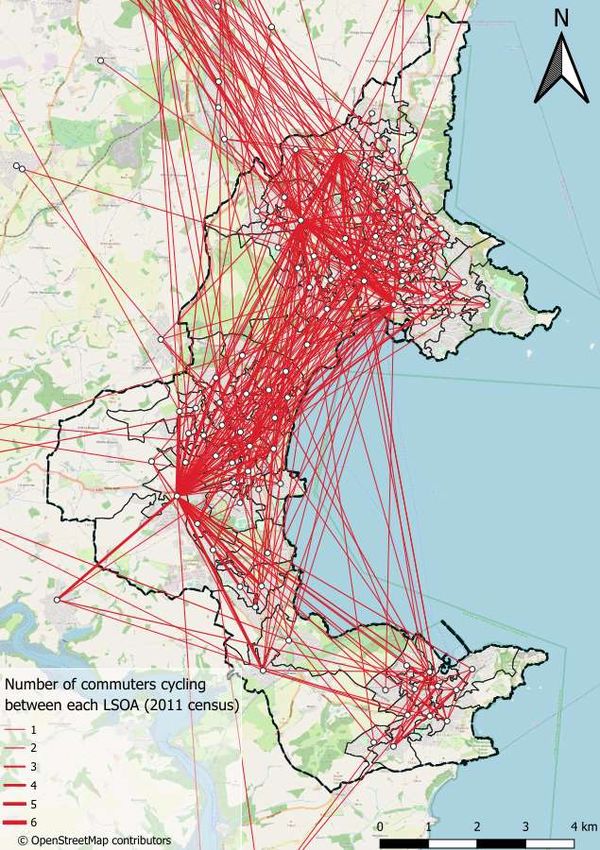
3   National and local policy context
    There are clear opportunities to support environmental, health, social and      LCWIPs identify improvements to build active travel networks and key           services. It also recognises that transport corridors can be attractive
    sustainable mobility goals that better connect people and places with           routes fit for all users.                                                      environments for wildlife, providing Green Infrastructure by connecting
    targeted investment in active travel infrastructure. This is evident in both                                                                                   areas of valued habitat and sustaining biodiversity.
    national and local policy that has guided and shaped the Torbay LCWIP           Local policy context
    process. A summary overview is provided below.                                                                                                                 Growth areas and local plan designations
                                                                                    Local policy relating to walking and cycling is contained in a range of
                                                                                    documents, outlined below. These policy documents show a strong level          The Local Plan sets out housing and employment growth areas in Torbay,
    National policy context
                                                                                    of support for cycling and walking. Several documents, including the           including strategic sites at Edginswell, around Torquay Hospital, and to
    Gear Change: A bold vision for cycling and walking (DfT 2020)                   Local Plan, are currently being reviewed, making this an ideal time to bring   the West of Paignton. The Local Plan also designates core tourism
                                                                                    forward and integrate further cycling and walking proposals.                   areas, and town, district, and neighbourhood centres (see Figure 5.1).
    Sets out Government’s vision for delivery of far higher quality cycling
    infrastructure, focusing on segregated cycle routes with local authorities      Key local policy documents include:                                            Local policy recognises that Torbay’s town centres are in decline and
    being expected to deliver a step change in the Level of Service for cycling
                                                                                                                                                                   must change. The Transformation Strategy for Torbay’s Town Centres
    and walking. It states, “Cycling and walking will be the natural first choice   ▪   Torbay Council Community & Corporate Plan, 2019
                                                                                                                                                                   2017 notes that Torquay and Paignton town centres are on the “critical
    for many journeys with half of all journeys in towns and cities being cycled    ▪   Torbay Local Plan 2012-2030 (under review)
                                                                                                                                                                   list” and require immediate action, with much more emphasis on, and
    or walked by 2030”. It establishes “Active Travel England” that will assess     ▪   Torquay, Paignton, Brixham Town Centre Masterplans 2015 & 2017
                                                                                                                                                                   investment in, consumer experience. The Torquay, Paignton, and
    local authorities’ performance on active travel, with findings influencing      ▪   Torbay Harbour Authority Port Masterplan, 2013
                                                                                                                                                                   Brixham Town Centre Neighbourhood Plans and Masterplans include
    the funding authorities receive across all transport modes.              The    ▪   Torquay, Paignton, Brixham Neighbourhood Plans 2018
                                                                                                                                                                   proposals for this transformation detailed in the following section along
    accompanying Local Transport Note 1/20 Cycle Infrastructure Design              ▪   Transformation Strategy for Torbay’s Town Centres 2017
                                                                                                                                                                   with wider transport proposals.
    sets out new ambitious cycle design standards.                                  ▪   Torbay Green Infrastructure Delivery Plan 2010 (under review)
                                                                                    ▪   Torbay Highways Design Guide (2020) and Urban Design Guide                 Transport and placemaking schemes
    Cycling and Walking Investment Strategy (DfT 2017)
                                                                                        (2006)
    Aims to make active modes a natural choice. Locally targeted investment         ▪   Local Transport Plan (LTP3), Devon and Torbay Strategy 2011-2026           LTP3 notes Torbay has made great progress in providing infrastructure
    via LCWIPs assist to connect people with places – creating vibrant,             ▪   LTP3 Torbay Implementation Plan (2016/17 – 2020/21)                        such as cycle lanes and promoting cycling for commuting and leisure use.
    healthier and productive places and communities.                                ▪   Torbay Sport Facilities Strategy 2014-2021                                 This was reflected in a 53% increase in peak cycling trips during the
    Future of Mobility: Urban Strategy (DfT 2019)                                   ▪   Torbay’s Joint Health and Wellbeing Strategy 2018-22                       second Torbay Local Transport Plan period from 2006-2011.
                                                                                    ▪   Healthy Torbay Supplementary Planning Document, 2017
    Nine principles to address the challenge of transforming towns and cities       ▪   South Devon Area of Outstanding Natural Beauty (AONB)
    to meet current and future transport demands. Includes the principle that           Management Plan 2019 – 2024
    ‘walking, cycling and active travel must remain the best option for short       ▪   English Riviera Destination Management Plan 2017-21
    urban journeys’.                                                                ▪   Torbay Heritage Strategy, 2021-26
    Everybody Active, Every Day (Public Health England 2014)                        ▪   Torbay Council Equality Objectives, 2016
                                                                                    ▪   Torbay Council Director of Public Health Annual Report 2019
    Indicates how the built and natural environment impact on the travel
                                                                                    ▪   Torbay Council Economic Recovery Plan 2020
    choices people make and highlights the necessity for effective urban
    design and transport systems which create ‘active environments’ to              Key relevant themes emerging from local policy are set out on the
    promote walking, cycling and more liveable communities.                         following pages.
    Clean Air Strategy (DEFRA 2018)
                                                                                    Policy support for cycling and walking
    Outlines how achieving modal shift is key to delivering emissions
    reduction. LCWIPs have a part to play in tackling the climate emergency         There are strong levels of support for walking and cycling in existing local
    by reducing emissions through the delivery of walking and cycling options       policy. Aspiration 2 of the Local Plan, to “Achieve a better connected,
    for journeys.                                                                   accessible Torbay and critical infrastructure”, seeks to improve cycling
                                                                                    and walking routes and encourage active travel. The Neighbourhood
    Inclusive Transport Strategy (DfT 2019)                                         Plans and Supplementary Planning Documents also include cycling and
    An inclusive transport system must provide inclusive infrastructure,            walking as key elements. The Local Transport Plan (LTP3) recognises
    with streetscapes designed to accommodate the needs of all travellers.          the role the active travel schemes can play in supporting the local
                                                                                    economy, improving health, and access to education, employment and

    Torbay Local Cycling and Walking Infrastructure Plan (LCWIP)                                                                                                                                                     FOR CONSULTATION
                                                                                                                                                                                                                           MARCH 2021
                                                                                                                                                                                                                                Page 3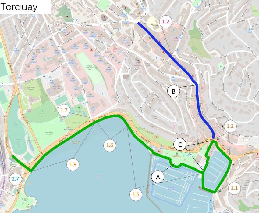
▪   Torquay seafront – new roundabout at Rathmore Road junction
                                                                                 with Torbay Road, with associated pedestrian, cycle and
                                                                                 highway improvements
                                                                             ▪   Junction Improvements
                                                                             ▪   Paignton Town Centre pedestrian, road traffic, rail station
                                                                                 improvements as part of a regeneration package
                                                                             ▪   Clennon Valley Off-Road Pedestrian and Cycle Route
                                                                             ▪   Ring Road Active Travel Corridor
                                                                             ▪   Goodrington to Brixham Pedestrian & Cycle Route

                                                                                                                                                  Figure 3.3. Paignton Town Centre Masterplan proposals

Figure 3.1. Transport proposals for Torbay in LTP3                                                                                                The Paignton Town Centre Masterplan SPD (2015) proposes an overhaul
A number of transport improvements were set out in LTP3 (Figure 3.1):                                                                             of the highways network, including eliminating the one-way system
                                                                                                                                                  through the town, and creating new public spaces. This includes
   ▪   Development of a National Cycle Route linking Torquay,
                                                                                                                                                  pedestrianising the western end of Torbay Road, the south side of Palace
       Paignton, and Brixham with onward links to Newton Abbot and
                                                                                                                                                  Avenue, and the middle section of Winner Street. The masterplan
       Totnes
                                                                                                                                                  includes a Public Realm Framework, proposing a number of streetscape
   ▪   Western Corridor Improvements                                      Figure 3.2. Torquay Town Centre Masterplan proposals
                                                                                                                                                  improvements (Figure 3.3).
   ▪   Park & Rides                                                       The Torquay Town Centre Masterplan SPD (2015) proposes further
   ▪   A new rail station at Edginswell                                   development between the harbour and Upton Park to the north, with key   In March 2020 a business case was submitted by Torbay Development
                                                                          development sites identified along this route. The plan proposes        Agency asking the Government for an £18.8 million investment to deliver
Further schemes are identified in the LTP3 Implementation Plan:           enhancing the harbour as a leisure and entertainment hub, relocating    a range of projects in Paignton Town Centre, including new housing,
   ▪   Brixham Town Centre Public Realm Improvements to introduce         some bus stops and improving the pedestrian environment (Figure 3.2).   public space improvements, and a flood defence scheme.
       shared, flexible space, reduce traffic speeds and quality public   This element of the masterplan has secured funding and is being
       space                                                              delivered as part of The Strand Townscape Improvements scheme.

Torbay Local Cycling and Walking Infrastructure Plan (LCWIP)                                                                                                                                       FOR CONSULTATION
                                                                                                                                                                                                         MARCH 2021
                                                                                                                                                                                                              Page 4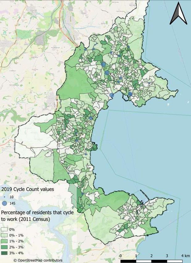
Health and inequality issues                                                Torbay is the most deprived local authority area in the South West. A
                                                                                                                                                       female living in the most deprived area of Torbay will live, on average 8.9
                                                                           Torbay’s Joint Health and Wellbeing Strategy and other local policy notes   years less than if they lived in the least deprived area. For males, this is
                                                                           that Torbay offers a great quality of life for individuals and families.    5.2 years. The Strategy aims to create places where people can live
                                                                           However, like many coastal areas, Torbay has its challenges. There are      healthy and happy lives, including by getting more people moving actively.
                                                                           high levels of poverty and deprivation with not enough opportunities for    The most deprived areas in Torbay include Paignton and Torquay town
                                                                           young people.                                                               centres (see Figure 3.5).

                                                                                                                                                       The importance of tourism

                                                                                                                                                       The English Riviera Destination Management Plan 2017-21 highlights the
                                                                                                                                                       importance of tourism for the bay and sets out future aspirations.

                                                                                                                                                       In 2015, over 4.5 million trips were taken to Torbay with £436 million spent
                                                                                                                                                       by those visitors. The bay has a strong and loyal UK market, attracting
                                                                                                                                                       97% of its visitors from the UK and has an extremely high repeat visitor
                                                                                                                                                       rate of 87%.

                                                                                                                                                       The plan sets out a range of priorities and actions to enhance the tourism
                                                                                                                                                       offer, including:

                                                                                                                                                           ▪   Extending the season to attract new domestic and international
                                                                                                                                                               visitors and overcome extreme seasonality in peak summer
                                                                                                                                                               months
                                                                                                                                                           ▪   Define Torbay’s cultural offer, making the most of cultural assets
                                                                                                                                                               including Agatha Christie and UNESCO Geopark
                                                                                                                                                           ▪   Develop experiences to exploit new opportunities and satisfy the
                                                                                                                                                               needs of new visitor markets
                                                                                                                                                           ▪   Maximise the trend in “staycations”, with additional focus on
                                                                                                                                                               international visitors, under 35s, business/conference tourism

Figure 3.4. Green Infrastructure Delivery Plan proposals

Although prepared a decade ago and under review 2010, the Torbay
Green Infrastructure Delivery Plan includes numerous proposals for
new/improved cycleways and “green trails” across Torbay, including a
coastal cycling route to form part of the National Cycle Network. There
are also proposals for a cycle hire scheme. The plan seeks to create and
                                                                           Figure 3.5. Deprivation in Torbay
enhance accessible wild play space and work, and to provide new
opportunities for outdoor activities and sport.

Torbay Local Cycling and Walking Infrastructure Plan (LCWIP)                                                                                                                                               FOR CONSULTATION
                                                                                                                                                                                                                 MARCH 2021
                                                                                                                                                                                                                      Page 5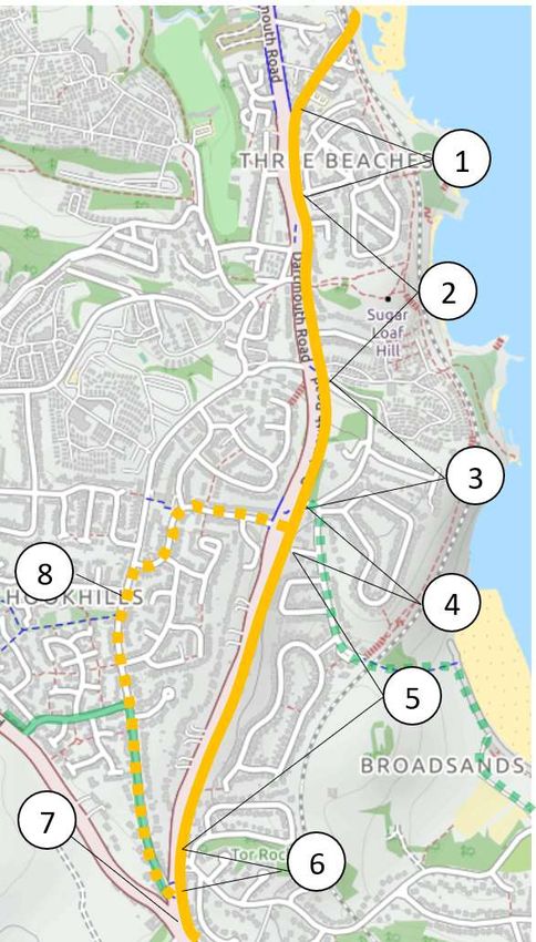
4   Existing cycling and walking travel patterns
    In the 2011 Census, 15% of Torbay residents travelled to work on foot,
    and just 1% by bicycle. However, 58% of commute trips were less than
    5km, indicating there is potential for further growth by making cycling to
    work viable and attractive for more people. Since 2011, walking and
    cycling rates in Torbay have continued to increase. The creation of cycle
    facilities including Paignton Velopark, Geopark Cycle Loop, mountain
    biking and BMX facilities, are all helping to develop a cycling culture in the
    bay. Investment through the Local Sustainable Transport Fund has
    helped deliver new routes linking Torbay Hospital to Torquay Town
    Centre, and links towards Paignton.
    Nonetheless, Torbay still faces significant challenges to increasing cycling
    use in particular, including:
        ▪    Low current levels of cycling, particularly when compared to
             other urban areas in England.
        ▪    Hills, that are a significant barrier to increased cycling for many
             people, although the increased availability of electric bikes may
             be helping to overcome this.
        ▪    Fragmented existing cycling network, with limited provision of
             dedicated segregated cycle routes, separate from both
             pedestrians and motor vehicles.
        ▪    Extensive one-way systems in Torquay, Preston, Paignton, and
             Brixham, with no contraflow facilities for people cycling, acting
             as a barrier for many people.
    In 2018, “Beat the Street” Torbay surveyed 850 residents on their
    perceptions of cycling and walking in the bay.          Overall, 47% of
    respondents felt it was ‘somewhat easy’ or ‘very easy’ to travel by cycle
    or foot. When asked what could be improved, the most popular responses
    were cycle paths, walking infrastructure, and improved/safer roads.
    Nationally, the Sustrans “Bike Life” survey is the biggest assessment of
    cycling in urban areas in the UK and Ireland. Over 17,000 randomly
    selected respondents in 14 cities participate in the survey. Key findings
    are that safety is the biggest barrier to cycling, and that cycle routes         Figure 4.1. Residents that walk to work                                     Figure 4.2. Residents that cycle to work
    separated from pedestrians and motor vehicles are significantly more
    likely to encourage people to cycle than other forms of cycle infrastructure.    The highest levels of walking to work in Torbay are within Torquay and      There are typically low levels of cycling to work across most of Torbay,
                                                                                     Paignton town centres, with up to 30% of employed residents walking to      with only small pockets where cycling use raises to a maximum of 4% of
                                                                                     work in some areas (Figure 4.1). Outside of the town centres, levels of     employed residents (Figure 4.2). Analysis of cycle count data shows the
                                                                                     walking are markedly lower, despite being well within a normal 2km          highest recorded cycle flows in Torquay, particularly on the corridor
                                                                                     walking distance, indicating that there are local issues reducing walking   between the Torquay rail station and the hospital.
                                                                                     rates.
    .

    Torbay Local Cycling and Walking Infrastructure Plan (LCWIP)                                                                                                                                                  FOR CONSULTATION
                                                                                                                                                                                                                        MARCH 2021
                                                                                                                                                                                                                             Page 6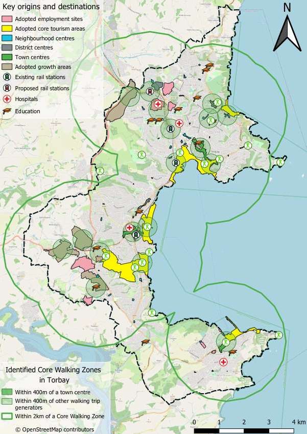
Tweenaways
Figure 4.3. 2011 Commuter cycle flows. Increased width = increased Figure 4.4. School cycle flows. Increased width = increased usage. Figure 4.5. Strava cycle flows. Brighter colours = increased usage.
usage (Source: Propensity to Cycle Tool) (Source: Propensity to Cycle Tool) (Source: Strava)
Figure 4.3 shows the estimated routes taken by people cycling to work in While commute trips are important they do not represent all cycle trips. Finally, outputs from the Strava global heatmap
Torbay in 2011, for the top 30% of cycle routes only. The route from Figure 4.4 shows estimated cycle to school trips based on the 2011 school (www.strava.com/heatmap), show anonymised data collected from
Tweenaways to Paignton town centre along Totnes Rd, and the route census data. Reported cycling levels are typically very low, but do again people cycling using the Strava mobile app. While the results are typically
between Paignton and Torquay town centres are by far the most popular highlight Totnes Road around Paignton Community & Sports Academy as skewed towards more confident sports/leisure cyclists, the results again
routes in all current and future scenarios in the Propensity to Cycle Tool an important route. highlight the importance of the coastal route between Paignton and
(PCT) (see www.pct.bike for further information on the PCT). While the Torquay, and the route from Torquay station, to the hospital, and towards
2011 cycle flows are low, the outputs also indicate the highest flows are Newton Abbot.
within Torquay, with some cycle traffic also using the A380 and A3022
Brixham Road.
Torbay Local Cycling and Walking Infrastructure Plan (LCWIP) FOR CONSULTATION
MARCH 2021
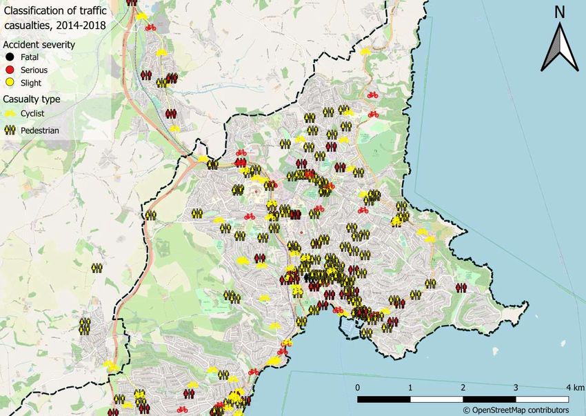
Page 7Figure 4.6. Traffic casualties,
pedestrians and cyclists 2014-18
(Torbay North)
Figure 4.6 shows pedestrian and
cycle casualties across the north of
Torbay, recorded by the Police. For
every injury shown on the map,
there will be additional injuries and
near misses not reported. The
mapping identifies safety issues,
but also helps identify where
pedestrian and cycle flows may be
greatest, broadly reflecting the
highest cycle flows shown in the
Propensity to Cycle Tool.
This highlights Torquay town centre
as a focus for safety issues. The
Hele Rd route from Torquay rail station to
Torquay Torquay hospital also stands out
hospital with a hotspot of serious injuries in
the vicinity of Cockington Primary
School.
B3199 Hele Road also stands out
Cockington as a particular hotspot for walking
Primary School Torquay town casualties.
centre
Torquay rail
station
Torbay Local Cycling and Walking Infrastructure Plan (LCWIP) FOR CONSULTATION
MARCH 2021
Page 8Figure 4.7. Traffic casualties, pedestrians
and cyclists 2014-18 (Torbay South)
Figure 4.7 highlights Paington and Brixham
town centres as a focus for safety issues.
Tweenaways Totnes Road between Paignton and
Tweenaways, and the A380 immediately
north of Tweenaways also stand out as
injury hotpots.
Torbay Local Cycling and Walking Infrastructure Plan (LCWIP) FOR CONSULTATION
MARCH 2021
Page 9Figure 4.8. Existing and proposed cycle
infrastructure (left)
Figure 4.8 shows existing cycling infrastructure
provision in Torbay, along with previous and
existing proposals for cycle routes considered by
the Council.
The map shows the fragmented nature of the cycle
network in Torbay, however, there are some routes
already served by traffic free cycle infrastructure.
Figure 4.9 shows suggestions for improvements
posted recently on the widenmypath.com website.
While the level of engagement is limited, the
requests are mainly concentrated on the coastal
cycle route, with proposals for segregated cycle
routes among the most popular proposed
measures.
Figure 4.9. Suggestions for improvements
Torbay Local Cycling and Walking Infrastructure Plan (LCWIP) FOR CONSULTATION
MARCH 2021
Page 10Best practice
This section sets out a number of best practice examples from access the
country that could be applicable to Torbay.
Bristol 20mph limits
Citywide 20mph speed limits were in introduced in Bristol in 2014 and
2015, following earlier successful pilot schemes. Over 80% of roads in
the authority area are now 20mph including many A roads. The £2 million
scheme aimed to improve health and well-being across the city, and also
reduce traffic casualties.
The University of the West of England (UWE) conducted a comprehensive
evaluation of the schemeiii, with key findings including:
▪ 94% of roads saw a reduction in speed, with largest reductions
on A and B roads that previously had the highest speeds, with
mean average speeds across all roads dropping to 23mph.
▪ Reduction in fatal, serious, and slight injuries, with estimated
annual savings of over £15m based on the DfT formula for the
cost of road traffic casualties.
▪ An estimated 2 child lives and 4 child serious injuries will be
prevented every 3 years.
▪ Walking and cycling across Bristol has increased, both among
cycling travelling to school and adults travelling to work.
Across the city, people walking to work increased from 17.5%
to 18.9%, and people cycling to work increased from 11% to
15% between 2010 and 2015. People driving to work
decreased from 53% to 44% over the same period.
▪ Despite some initial opposition a clear majority now support
20mph limits, with 62% supporting limits on residential roads
and 72% on busy streets.
The UWE evaluation concludes that the introduction of 20mph speed
limits in Bristol offers a model for other towns and cities across the UK,
who are seeking to reduce traffic speeds, cut road traffic casualties, and
promote community health and well-being. Many other towns and cities,
including nearby Newton Abbot are now exploring rolling out area wide
20mph zones.
Potential in Torbay…
While not current Torbay Council policy, area-wide 20mph limits could be
a good solution in Torbay, where a lack of road width and other constraints
may limit the ability to deliver dedicated cycling infrastructure in many
places.
Torbay Local Cycling and Walking Infrastructure Plan (LCWIP) FOR CONSULTATION
MARCH 2021
Page 11Exe Estuary Trail Co-bikes, Exeter
The Exe Estuary Trail is a cycle and walking link extending for over 16 Co-bikes was the UKs first on-street electric bicycle hire scheme,
miles from Dawlish to Exmouth, and Exeter Quay. The 10-year scheme operating across Exeter. Within two months of the relaunch of the scheme
cost around £17 million to develop, and has resulted in a high quality, with updated bikes in September 2019, they saw 450 new or returning
largely off-road, cycling and walking route. The route connects towns and members making 1200 trips on the bikes, with 75% of the users living in
villages, railway stations and ferries; providing easier active access Exeter. Plans are underway to expand to new sites across the city,
around the Exe Estuary, one of Devon’s most highly designated and including additional rail stations, new housing developments and key
protected environments. The trail forms part of the National Cycle Network employment hubs. The proposal to expand the eBike network in 2018
Route 2, as well as the East Devon Way and Exe Valley Way walking listed 14 potential sites at a total estimated cost of £240,000, including a
trails. mix of docked sites, dockless sites and site extensions.
The trail enables safe commuter cycling between the settlements around Potential in Torbay…
the Exe estuary. It also contributes to health and well-being by
E-bikes in Torbay, linked to new infrastructure in this LCWIP, could play
providing an easily accessible green infrastructure to residents along
an important role in increasing the number of people cycling.
the Estuary.
.
It enables the public to experience the wildlife of the Estuary with
opportunities for education and community engagement, and provides
opportunities for business growth and tourism.
The trail connects 80,000 residents in the area to Exeter and helped bring
about a significant increase in walking and cycling. Around 30% of
trips made on the trail occurring during commuter periods. The trail also
has a high proportion of leisure use and acts as a tourist attraction in
its own right.
The scheme has also led to increased footfall in businesses along the
route, as well as enabling more cycle hire locations and leading to an
increase in cyclists using the cycle ferry at Starcross.
Evaluation of expenditure for trail users across the Exe Estuary Trail,
Drake’s Trail and the Tarka Trail, suggests the trails result in £13.4 million Wayfinding, Littlehampton
in annual business turnover, 200 full time jobs, and health benefits
of over £3.5m per year.iv Littlehampton in West Sussex has deployed high quality mapping and
signage to highlight pedestrian areas of the seaside town and reconnect
Devon County Council run a ‘Share this Space’ campaign that the town centre to the seafront. Themed on a day out by the seaside,
encourages everyone to be alert, be patient and be nice. This helps create the graphic style is bright and lively. The mapping highlights landmarks
a pleasant environment for everyone. and attractions and key pedestrian routes to connect the public realm.
https://www.traveldevon.info/cycle/safe-cycling/share-this-space/ The project builds on the approach of Legible Bristol, Bath, and similar
wayfinding schemes in London, which use high quality on-street
signage, paper mapping, public art, and associated projects.
Potential in Torbay…
Potential in Torbay…
As set out in section 5, several of the proposed
LCWIP routes could provide a similar amenity in A similar project in Torbay could help both locals and visitors navigate
Torbay, acting as a tourist attraction, whilst the area and enhance the public realm.
providing a valuable transport link for residents.
Torbay Local Cycling and Walking Infrastructure Plan (LCWIP) FOR CONSULTATION
MARCH 2021
Page 12Segregated cycle routes and Liveable Healthy Streets Indicators
Neighbourhoods
Towns and cities across the UK are adopting Dutch style design principles
including delivery of segregated cycle routes and Liveable or Low-Traffic
Neighbourhoods. These approaches were recently endorsed by central
government in its new cycle infrastructure design guidance.
Safety and the perception of safety is the main reason why most people
do not cycle, or do not cycle more. Segregated cycle infrastructure breaks
down these barriers – providing separation from other road users on both
links and at junctions.
Segregated cycle routes have been delivered across Bristol city centre in
recent years, leading to significant increases in the number of people
cycling. The schemes provide direct and comfortable routes, with high
levels of priority for people walking and cycling. This includes continuous
footways and cycleways over side roads, and enhanced priority at
junctions and parallel “tiger” crossings.
Local authorities across the country are also developing liveable
neighbourhoods and Healthy Streets to deliver safer, quieter, less polluted
and more pleasant streets. They provide the opportunity to create space
for social activity, play and greening. Introducing liveable neighbourhoods
leads to:
▪ more active travel
▪ improvements in physical health & wellbeing
▪ greater social cohesion
The term “modal filter” refers to infrastructure that allows people walking,
cycling, and sometimes public transport, but prevents through movements
of motor traffic. Modal filters can be the single most effective intervention
installed along a street to reduce through traffic and create safer streets
for cycling and walking.
The best-known liveable neighbourhood in the UK is in Waltham Forest.
The £2.3 million scheme included cycle streets, continuous footways,
pedestrian crossings, school streets, pocket parks and trees, and
“Bikehangars”, which provide secure cycle parking for residents in the
same footprint as half a car parking space.
Torbay Local Cycling and Walking Infrastructure Plan (LCWIP) FOR CONSULTATION
MARCH 2021
Page 135 Network planning for cycling
Current & future origins and destinations
The LCWIP Technical Guidance notes that identifying demand for a
planned cycle network should start by mapping the main origin and
destination points.
In line with the guidance, census output areas where chosen to represent
journey origins from existing residential areas. Additional origins and
destinations were identified as shown in Figure 5.1, including:
▪ Future housing and employment sites adopted in the Local Plan
▪ Core tourism areas and attractions
▪ Town, District, and Neighbourhood Centres as identified in the
Local Plan
▪ Current and proposed rail stations
▪ Hospitals and secondary schools
Cross-boundary journeys to/from outside of Torbay were also considered,
with particularly strong demand for travel north of Torquay towards
Newton Abbot. Since the 2011 census it’s likely that the number of people
cycling between Newton Abbot and Torbay has increased due to the
South Devon Link Road and associated improvements on Torquay
Road/Newton Toad. In addition, each of the datasets referred to in Section
4, including cycling to school data, Strava data, and road collision data,
were considered when identifying potential cycle trips both now and in the
future.
Desire lines
Geographic Information System (GIS) software was used to locate and
map the principal trip origins and destinations and determine ‘desire lines’
for movement between them as set out on the following page.
Figure 5.1. Origins & Destinations
Torbay Local Cycling and Walking Infrastructure Plan (LCWIP) FOR CONSULTATION
MARCH 2021
Page 14Figure 5.4. Top Desire Lines (shown as thick coloured lines)
Taking into account all of the data previously discussed, the top desire
Figure 5.2. Census 2011 cycle to work travel patterns lines shown in Figure 5.4 were identified, including:
Figure 5.3. 2011 Commuter cycle flows (Source: Propensity to Cycle
Figure 5.2 shows cycle to work trip patterns (as straight lines) across Tool) ▪ Torquay Harbour to Paignton, as the top priority
Torbay in 2011. The map highlights a range of key movements, ▪ An emerging cycle network in Torquay, connecting the town
As already shown in section 4, Figure 5.3 is taken from the Propensity to
including between Paignton and Torquay, and north from Torquay. A centre, train station, hospital, growth areas, and key tourist and
Cycle Tool (PCT), which maps the census desire lines to the road
complex pattern of movement around Torquay is also shown, which school destinations
network. The PCT includes the ability to test a range of future scenarios
reinforces the data presented in section 4. There is less current
based on different assumptions about growth in cycling levels. The ▪ Paignton to Collaton St. Mary
demand for cycle trips in and around Brixham than the other towns.
pattern of cycle trips in the PCT for Torbay is broadly similar in all current
and future scenarios, with key routes including Totnes Road between ▪ Paignton to Brixham
Tweenaways and Paignton, and Torbay Road between Paignton and An additional significant desire line was identified between Tweenaway
Torquay. A broad cycle network within Torquay itself also emerges. and Broadsands. However, this was not taken forward as part of the
LCWIP development as there is already a generally good level of cycle
provision on this route.
Torbay Local Cycling and Walking Infrastructure Plan (LCWIP) FOR CONSULTATION
MARCH 2021
Page 15Route development process Shared use path
Having determined the desire lines, the next phase of the process is to A route, path, or part of any public space which
identify real world routes that can accommodate these desire lines. For people walking and cycling share, but where
example, via existing roads or paths, or identifying opportunities to create motor traffic is not permitted.
new routes. Modal filter / Low Traffic Neighbourhood
A route auditing process was undertaken for each of the route corridors.
A modal filter typically consists of a bollard,
Audits were undertaken by trained auditors carrying out site visits and the
planter, or other barrier that allows pedestrians,
Department for Transport’s Route Selection Tool (RST) was applied
cyclists, and occasionally public transport to pass,
consistent with the process shown in Figure 5.5. The main function of the
but not other motor traffic. Low traffic
tool is to assess the suitability of a route in its existing condition against
the core design outcomes of being coherent, direct, safe, comfortable neighbourhoods often deploy modal filters to
and attractive, then to undertake a comparison with the potential improved Figure 5.5. Route Audit Process (Source: LCWIP Technical Guidance reduce the volume of motor traffic through an
future condition. The process also considers the hilliness and gradient of for Local Authorities, DfT 2017) area.
the various route options. The process enables the easy comparison of Public realm improvements
alternative routes, should any be identified.
Measures that enhance the look and feel of an
Figure 5.5 shows the process used. The first route audited is the most Types of improvements area, including tree planting, street art, paving,
direct. If this is, or can be, made suitable for All Ages and Abilities cycling,
Improvements were developed according to the latest design standards, seating, and other features to make public spaces
then this is the preferred route option. If the most direct route cannot be
with key improvement types shown belowv. more attractive
brought up to a suitable standard, then the next most direct route is
audited, and the process repeated. For the majority of routes in Torbay, Segregated cycle path 20mph limits/zones and traffic calming
the most direct route was used as these can be brought up to the relevant
A cycle facility, physically separated from the Traffic calming includes features that physically
design standards.
areas used by motorists and pedestrians. It may or psychologically slow traffic. 20mph limits
The following factors were considered when undertaking the audits and be next to, or completely away from the refers to 20mph areas enforced by signs only.
determining the potential route improvements: carriageway. 20mph zones refers to 20mph enforced by signs
• The quality of existing cycling provision / infrastructure; Continuous footway/cycleway crossing and traffic calming.
• The potential of the route to connect other origins and Parklets
A method of giving people walking and cycling
destinations within the corridor;
priority over motor vehicle movements at side A small seating area or green space created for
• The potential for and feasibility of route improvements, based on
any apparent constraints; junctions. The footway material continues the public to enjoy on or alongside a footway.
• Identification of critical junctions, to determine how these could across the junction, giving a strong visual
be either avoided or enhanced to make the route more attractive, priority.
safe and direct for people cycling; and, Dropped kerb and tactile paving
Contraflow cycle route
• The potential for integration with other proposed improvements A feature to allow non-stepped access, usually
identified through the policy review and engagement with Allows people cycling to travel in the opposite
between a footway and carriageway, which is
officers, to add wider value. direction to one-way motor traffic. Can be
particularly useful for people cycling, people with
implemented with or without lane markings.
A suite of plans showing the context of each corridor and the proposed mobility issues, and people in wheelchairs or
improvements are shown on the following pages. Parallel / Tiger crossing mobility scooters. Tactile paving helps people with sight
A crossing similar to a zebra crossing, which impairments understand the street and crossing points.
accommodates people cycling as well as Wayfinding
walking.
Encompasses all of the ways in which people
orient themselves and navigate from place to
place.
Torbay Local Cycling and Walking Infrastructure Plan (LCWIP) FOR CONSULTATION
MARCH 2021
Page 16Bay Trails
Following the identification of key desire lines and the audit process, five major cycle routes are proposed, collectively branded as the
“Bay Trails”:
▪ Beaches Trail (North)
▪ Beaches Trail (South)
▪ Zoo Trail
▪ Hospital Trail
▪ Torquay Town Trail
The proposed trails would represent a step change in cycling infrastructure in Torbay, with over 27km of traffic free or low traffic cycle
routes, suitable for all-ages and abilities. Widened paths and dedicated routes will improve the accessibility for all, including for people
in mobility scooters.
The trails would deliver a new tourist attraction for the Bay, connecting existing tourist destinations and providing a destination in it’s
own right. The trails will help better connect people to the outstanding natural surroundings including beaches, harbours, parks, and
nature. They will help to regenerate town centres, and provide a new commute and school travel option for many residents, particularly
in the most deprived areas in central Paignton and Torquay.
Further details of the trails and the recommended improvements to deliver them are shown on the following pages. It should be
noted that the recommendations are at a very early stage of design, and further engagement, consultation, and design work
will be needed to further develop and deliver them. Through these further engagement and design stages, opportunities should
be explored to incorporate tree planting, habitat creation and other Green Infrastructure, Sustainable Urban Drainage Systems
(SUDS), playspace, and other elemtents to help to deliver wider Council objectives.
Following the prinicples of LTN1/20 Cycle Infrastructure Design, the recommended improvements aim to separate people cycling from
motor traffic and people walking through segregated cycle infrastructure wherever it is possible to do so. In line with LTN1/20, and as
detailed on the following pages, there are sections of the routes where this has not been achievable and shared use provision is
recommended. These are typically in lower footfall areas outside the busier central areas. Where shared use paths are recommended,
they will need to be carefully designed and managed to minimise potential conflict between people cycling and walking.
Figure 5.6 also shows key cycle schemes that are already in progress including along Babbacombe Road in Torquay, and through
Clennon Valley. The existing off-road cycle provision between Tweenaway and Broadsands is also shown, highlighting links to the
wider cycle network..
Figure 7.1 in section 7 shows how the Bay Trail routes could form the core of a longer-term aspirational cycle network for Torbay.
Figure 5.6. Bay Trails
Torbay Local Cycling and Walking Infrastructure Plan (LCWIP) FOR CONSULTATION
MARCH 2021
Page 17Beaches Trail
The Beaches Trail has huge potential to be a showcase All Ages and Abilities (AAA) route for Torbay, linking Torquay, Paignton,
and Brixham via the coast. The 14km trail has the potential to provide:
• Well used commuter route, serving some of the highest existing cycle commuter flows in the area between Paignton and
Torquay along Torbay Road
• Tourist attraction in itself, providing a reason to visit and spend time in Torbay, and providing access to existing tourist
attractions and the outstanding natural environment including beaches, parks, and nature
• Route linking several schools, as well as improving access to shopping areas and hospitals
• Serves the majority of deprived areas in Torbay, including the most deprived areas in central Torquay and Paignton
• Play space and wildlife corridor, incorporating improvements to sections of the South West Coast Path
• Opportunities for placemaking, art & culture, including incorporating public realm improvements around Torquay and
Paignton harbours, linked to proposed improvements in existing masterplan documents
• Better access to the coast for all
• Potential onward connections to the National Cycle Network (NCN) in Newton Abbot and Totnes if these connecting
routes are also improved. The section between Torquay Station and Paignton could potentially form part of the NCN.
The following pages detail the recommended improvements needed to deliver this trail. The route has been split into The Beaches
Trail (North) between Torquay and Paignton, and the Beaches Trail (South) between Paignton and Brixham. This reflects the
different characters of each area and also breaks the route down into smaller, more deliverable parts.
Torbay Local Cycling and Walking Infrastructure Plan (LCWIP) FOR CONSULTATION
MARCH 2021
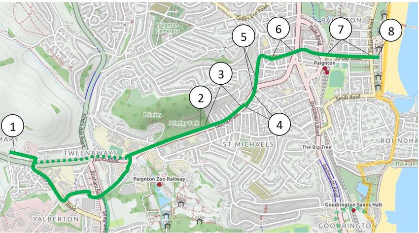
Page 18Beaches Trail (North)
Section 1: Torquay Harbour to Torquay Rail Station
This section of the Beaches Trail could be largely delivered as high-quality segregated cycle
provision, and incorporates a number of wider public realm and walking improvements, linked to
existing proposals in the Torquay Town Centre Masterplan and elsewhere. The recommended
improvements are:
1. Victoria Parade. Deliver new segregated cycle route. Through further engagement with the
community and stakeholders, consider opportunities to enhance Victoria Parada as a
destination. This could include further improvements to walking routes and the public realm,
providing enhanced spaces for people to enjoy the harbourside views and visit local retailers
and businesses, with new cycle parking provision.
2. The Strand. Deliver new segregated cycle route, linked to The Strand Townscape
Improvements scheme which will reinforce the quality of this area. (this section connects to the
Torquay Town Trail and Babbacombe Road cycle scheme).
3. Improve cycle provision on Palk St by reducing street clutter and providing a clear cycle
route. Priority cycle crossing on Vaughan Road.
4. Princess Gardens. Deliver new/improved segregated cycle route either through the gardens
(exact route to be confirmed) or via a new segregated cycle route adjacent to Torbay Road,
which would reduce conflict with people walking, but would be significantly more expensive.
Further engagement work with the community and stakeholders will be needed to develop the
proposals further.
5. Torbay Road. Create more space for walking and cycling on the south side of the
carriageway by reducing the central reservation width. Segregate people walking and cycling,
except where there insufficient width to do so.
6. Provide a minimum of 3m shared use path on the south side of this junction by reallocating
carriageway space. For example, this could consider a reduction in the number of eastbound
lanes. Alternatively, a banned right turn from Torbay Road westbound could also be
considered which would also reduce traffic flows on Belgrave Road. Motor vehicles that still
need to make this movement could do so via a u-turn at the proposed roundabout at Rathmore
Road (point 9).
7. Torbay Road. Reduce width of carriageway to deliver a new segregated cycle route and
improved walking environment. To include public realm improvements and traffic speed
reduction measures, as well as an increased number of pedestrian crossing points to improve
connectivity between the seafront and Abbey Gardens.
8. Deliver existing scheme for a new roundabout at Torbay Road junction with Rathmore Road.
The Rathmore Road roundabout scheme is currently in development and will subject to further
engagement and design work, including Road Safety Audits (this section connects to the
Hospital Trail).
Torbay Local Cycling and Walking Infrastructure Plan (LCWIP) FOR CONSULTATION
MARCH 2021
Page 19Beaches Trail (North)
Section 2: Torquay Rail Station to Hollicombe Park
This section of the Beaches Trail has the highest levels of existing cycle commuter flows and is also likely to have the greatest
potential for growth. As such, it is one of the most important sections of the proposed cycle network. The existing intermittent
painted on-road cycle lanes are not suitable for people of all ages and abilities, do not meet current design guidance, and need
to be upgraded. However, achieving fully segregated provision for people cycling on this section is not considered to be
achievable for the following reasons:
▪ There are significant physical constraints adjacent to the route including the sea wall, cliffs, railway line, and residential
properties.
▪ There are no alternative motor traffic/cycle routes available within a reasonable distance, and therefore no realistic
opportunities to divert either people cycling or people in motor vehicles to alternative routes.
▪ Continuous segregated cycle provision would require land acquisition (most likely involving compulsory purchase) from
around 20 properties, as well as extensive works to an embankment above a national rail route which is extremely
unlikely to be affordable or deliverable.
Based on site observations, footfall on this section is typically low and as such a shared use path is proposed for this section.
Shared use footpaths are compliant with the new Local Transport Note 1/20.
The recommended improvements are:
1. Reconfigure Torbay Rd southbound bus stop (linked to Rathmore Rd roundabout scheme), to allow more space for walking
and cycling.
2. Amend kerbline on the south side of Torbay Rd to create a 3m+ shared use path (segregate where total highway width
allows), with continuous footway/cycleway crossings of side roads.
3. Torbay Rd junction with Cockington Lane. Junction improvement to release space for walking and cycling. Further junction
design work including traffic surveys are needed to confirm the potential impacts and most suitable approach to delivering a
safe cycle route here. Consider removing dedicated turning lane for traffic turning right from Torbay Road onto Cockington
Lane (note: this movement would still be permitted). Explore options to rationalise the Livermead Hill section of the junction to
improve the walking and cycling environment, and overall safety of the junction, with associated public realm improvements.
There is also the potential to re-align the junction with limited land acquisition, which could further improve the utility of this
junction for all users. (this section connects to the existing Cockington Cycle Loop).
4. Reconfigure bus stop to create more space for walking and cycling.
5. Continue off-road cycle provision over rail bridge (enabled by planned bridge refurbishment scheme).
6. Remove informal parking on southbound carriageway to create more space for walking and cycling.
7. Improve existing crossing, increasing priority for people walking and cycling.
Torbay Local Cycling and Walking Infrastructure Plan (LCWIP) FOR CONSULTATION
MARCH 2021
Page 20Beaches Trail (North)
Section 3: Hollicombe Park to Paignton Pier
This section of the Beaches Trail utilises the existing shared use path through Hollicombe Park to Marine Parade, and
existing segregated cycle provision along sections of Preston seafront, filling in gaps to create a more consistent route
for all ages and abilities. The recommended improvements are:
1. New minor kerb build out and realignment where existing shared use path meets Marine Parade to improve access
and prevent parked vehicles obstructing the path.
2.Marine Parade (behind beach huts). On-road provision proposed due to very low traffic flows. Consider removing a
small number of parking spaces, to allow for more comfortable passing places. Provision of signage and wayfinding to
direct people cycling to use the on-road route rather than in front of the beach huts, which is likely to cause conflict with
people walking and beach hut users.
3. Reconfigure junction of existing cycle path on Marine Drive to Marine Parade to maintain segregation and improve
the directness and legibility of this small section of route.
4. Marine Drive. Re-allocate carriageway space to create a new segregated cycle route on the west side of Marine
Drive. This would also improve the quality of this key section of the South West Coast Path for people walking and
create a more attractive walking link between Paignton and Preston promenades. Potential options include conversion
to one-way southbound only for motor traffic. Options need to consider access to the immediate area for high vehicles
for which there are no alternative routes due to low bridges with a maximum height of 4.2m. It is unclear how many
high vehicles access the area, which could be confirmed with a traffic survey, however, access for these vehicles could
potentially be managed even with an extended one-way system in place.
5. Eastern Esplanade. The existing on-carriageway provision is broadly acceptable for people cycling due to the low
traffic volumes, but could be improved with provision of a fully segregated cycle route. Consider moving parking to the
rear side of the promenade to improve safety. This would also improve the walking and cycling experience on the
promenade by opening up sea views for more people. (this section connects to the proposed Zoo Trail).
Torbay Local Cycling and Walking Infrastructure Plan (LCWIP) FOR CONSULTATION
MARCH 2021
Page 21You can also read