BEAVER BROOK ANTIMONY MINE REVISITED: AN UPDATE ON OPERATIONS AND NEW STRUCTURAL AND GEOLOGICAL OBSERVATIONS - Natural Resources
←
→
Page content transcription
If your browser does not render page correctly, please read the page content below
Current Research (2018) Newfoundland and Labrador Department of Natural Resources
Geological Survey, Report 18-1, pages 123-152

                  BEAVER BROOK ANTIMONY MINE REVISITED: AN UPDATE
                       ON OPERATIONS AND NEW STRUCTURAL AND
                             GEOLOGICAL OBSERVATIONS
                                      H.A.I. Sandeman, C. Peddle1 and R. Newman2
                                                Mineral Deposits Section
             1
               Department of Earth Sciences, Memorial University of Newfoundland, St. John’s, NL, A1B 3X5
                      2
                        Beaver Brook Antimony Mines Inc., 1 Mine Site Rd, Glenwood, NL, A0G 2K0

                                                                                    ABSTRACT

     Epithermal, fracture-controlled stibnite–quartz mineralization at Beaver Brook in central Newfoundland was discovered
in 1989 during regional gold exploration surveys. Mineralization occurs along three zones (West, Central and East), disposed
along a 4-km strike length outboard of the eastern margin of the Mount Peyton intrusive suite; the latter two zones have delin-
eated reserves. The mine is in the East zone, where mineralization consists of massive stibnite veins, vein breccia, vug fillings
and fracture coatings that occur in the hanging wall of an 065º-trending, steeply to moderately southeast-dipping fault. Gold
abundances are typically low in the East zone stibnite–quartz ore, however, near the Central zone, diamond-drill hole (DDH)
intercepts have yielded up to 26 g/t Au over 2 m, with and without coincident Sb. Beaver Brook Antimony Mine opened in
1997, but ceased after 8 months of operations. In 2007, after an ownership change, the mine was dewatered, reopened and
processed ore until 2012. Exploration of the mine lease has continued through the acquisition of IP geophysical surveys, soil
surveys and completion of a further 100 DDH throughout previously unexplored parts of the property. Present-day indicated
resources consist of 0.5 Mt of ore at 4.17% Sb.

     Data is presented of post-Silurian, northwest-directed thrusting of the Ordovician Davidsville Group over the Silurian Indian
Islands Group. Structural analysis indicates that at least three low-angle reverse faults (thrusts) place Darriwilian to Katian units
over Wenlock to Lockovian units, with the thrust panels widening to the southwest. At the East zone, all rocks exposed at surface
comprise Silurian rocks of the Indian Islands Group and the Ten Mile Lake formation. The discovery of more Sb resources
requires a better understanding of the major fault structures in the region (i.e., which faults control and/or host the mineraliza-
tion) and might be assisted through detailed aeromagnetic and other geophysical surveys. Moreover, the positive indication of
new auriferous zones on the lease indicates an alternative commodity for further exploration.

                           INTRODUCTION                                                  that is considered at strategic risk in terms of supply, and
                                                                                         new resources need to be discovered (BGS, 2015).
     Antimony (Sb) is a non-precious but globally ‘strategic’
metal (BGS, 2015; Mudd et al., 2017), whose most common                                       Relative to the precious and base metals, antimony is not
ore mineral is stibnite (Sb2S3). Antimony is widely used in                              a particularly well-studied commodity. In many mineralizing
flame-retardants, but is also used in alloys with other metals,                          systems, antimony may be closely associated with a number
lead-acid batteries, low-friction metals, and cable sheathing.                           of other ore metals such as tungsten, molybdenum and gold
Antimony compounds are also commonly used in the man-                                    (e.g., Lake George Mine area, Seal et al., 1988; Yang et al.,
ufacturing of paints, ceramic enamels, glass and pottery.                                2003, 2004; Costerfield Mine, Wilson et al., 2017; Quinglong
Very pure antimony is used in some semiconductor diodes                                  deposit, Chen et al., 2018). Antimony and gold together, com-
and in infrared detectors (Butterman and Carlin, 2004;                                   monly occur with anomalous and variable enrichment of a
Grund et al., 2006). For most of the last century, the global                            number of other characteristic trace elements such as As, Pb,
antimony market has been largely under the control of China                              W, Mo, Hg, Bi and Te. These diverse metal associations are a
as that country presently holds almost 50% of the worlds                                 notable characteristic of the intrusion-related gold systems
antimony reserves and, in 2016, produced >75% of the glob-                               such as those of the Tintina Gold Belt of Alaska and Yukon
al supply (Guberman, 2016). Antimony is, therefore, a metal                              (e.g., Fort Knox, Donlin Creek; Sillitoe and Thompson, 1998;

                                                                                                                                                   123
CURRENT RESEARCH, REPORT 18-1
Thompson et al., 1999; Hart, 2007), but also of the Carlin- area (NTS 2D/11). Exploration for gold and precious metals
type of epithermal, structurally controlled calcareous sedi- in the region commenced as part of the island-wide, grass-
ment-hosted gold deposits (Cline et al., 2005; Muntean et al., roots gold exploration boom of the late 1980s. This explo-
2011). A notable characteristic of many epithermal, fracture- ration was a result of financial market conditions and the rel-
controlled antimony deposits (e.g., Bliss and Orris, 1986; atively high and steady price of gold (~US$350‒450 /oz) at
Gumiel and Arribas, 1987; Berger, 1993; Kontak et al., 1996; that time, and resulted in the discovery of many precious-
Neiva et al., 2008; Bortnikov et al., 2010; Liang et al., 2014; metal-mineralized zones throughout Newfoundland. In
Wilson et al., 2017; Chen et al., 2018) is the close spatial and 1989, prospectors exploring for gold with the Noranda‒
temporal association with Py–Aspy ± Au ± W ± Mo ± Pb Noront Grub Line Syndicate discovered stibnite-mineral-
mineralization. ized boulders in Beaver Brook, a small southeast-flowing
tributary of the Northwest Gander River (Tallman, 1989a).
The Beaver Brook Antimony Mine in central This discovery prompted extensive further exploration of
Newfoundland is located ~42 km southwest of the town of the surrounding area, and the subsequent delineation of the
Glenwood-Appleton, and 1 km northwest of the Northwest stibnite mineralization now defined at the East zone of the
Gander River (Figures 1 and 2) in the Eastern Pond map Beaver Brook Antimony Mine.
Although the mine has been in
The Island of existence for 20 years, and considering
Newfoundland OVERLAP SEQUENCES
Devonian to Carboniferous sedimentary rocks the relatively large size (2.2 million
Silurian sedimentary and volcanic rocks tons) and high grade (avg. 3.99% Sb at
INTRUSIVE ROCKS 1.5% cut off) of the East zone deposit
Ordovician--Devonian intrusions (Morrissy and House, 1998), the min-
Neoproterozoic--Cambrian intrusions eralization, host rocks, and structural
- ne
rte Li setting are poorly understood. This is a
Ve ton
HUMBER ie p result of a number of factors including:
Ba rom DUNNAGE ZONE
ZONE B
Notre Dame ne Exploits thick fluvioglacial deposits and a
Subzone Li Subzone
n
di
a dearth of exposed bedrock (Batterson,
In ne
d Li ne
Re y Li 1999); a lack of regional, property-
Twillingate Ba U B
D og GR wide and deposit-scale geophysical
GANDER
ZONE data; structural complexity of the host
Deer
Corner Lake
ault
rocks; a variable, but commonly low,
Brook Gander er F
Grand Falls Dov price of antimony over much of the
Beaver Brook
Antimony Mine
past two decades, and, turnover in
?
AVALON
mine lease ownership and a lack of
ZONE continuity of mine site knowledge.
Figure 2
Great Bend
Complex This report forms a component
of an ongoing, broader study
(Sandeman et al., 2017; H. Sandeman,
Port Aux St. John’s
Basques unpublished data, 2017) of the nature
and style of polymetallic Au–Ag–Sb–
As mineralization spatially associated
with the major structural feature
HUMBER ZONE
Neoproterozoic to Ordovician
DUNNAGE & GANDER ZONES
Cambrian to Silurian
AVALON ZONE
Neoproterozoic to Ordovician
termed the Dog Bay Line (Figures 1
Metasedimentary rocks Marine clastic and Sedimentary rocks and 2; Williams et al., 1993). This
volcanic rocks
Platformal carbonate rocks study builds upon extensive previous
Ophiolitic rocks Volcanic rocks
Clastic, carbonate &
volcanic rocks Neoproterozoic--Ordovician
work including: geological mapping
Meso-Neoproterozoic Metasedimentary rocks & (Anderson and Williams, 1970;
migmatite
Gneiss and granite Blackwood, 1980a, b, 1981a, b, 1982;
Dickson, 1992, 1993, 1994, 1996,
Figure 1. Simplified geological map of Newfoundland showing the major litho- 2006); geochronology (Dunning, 1992,
tectonic domains and their bounding structures. Also shown is the location of 1994; Dunning and Manser, 1993;
Figure 2 and the Beaver Brook Antimony Mine with respect to major geological O’Driscoll and Wilton, 2005; McNicoll
elements of the region (after Williams et al., 1988; Colman-Sadd et al., 1990). et al., 2006; Dickson et al., 2007;
124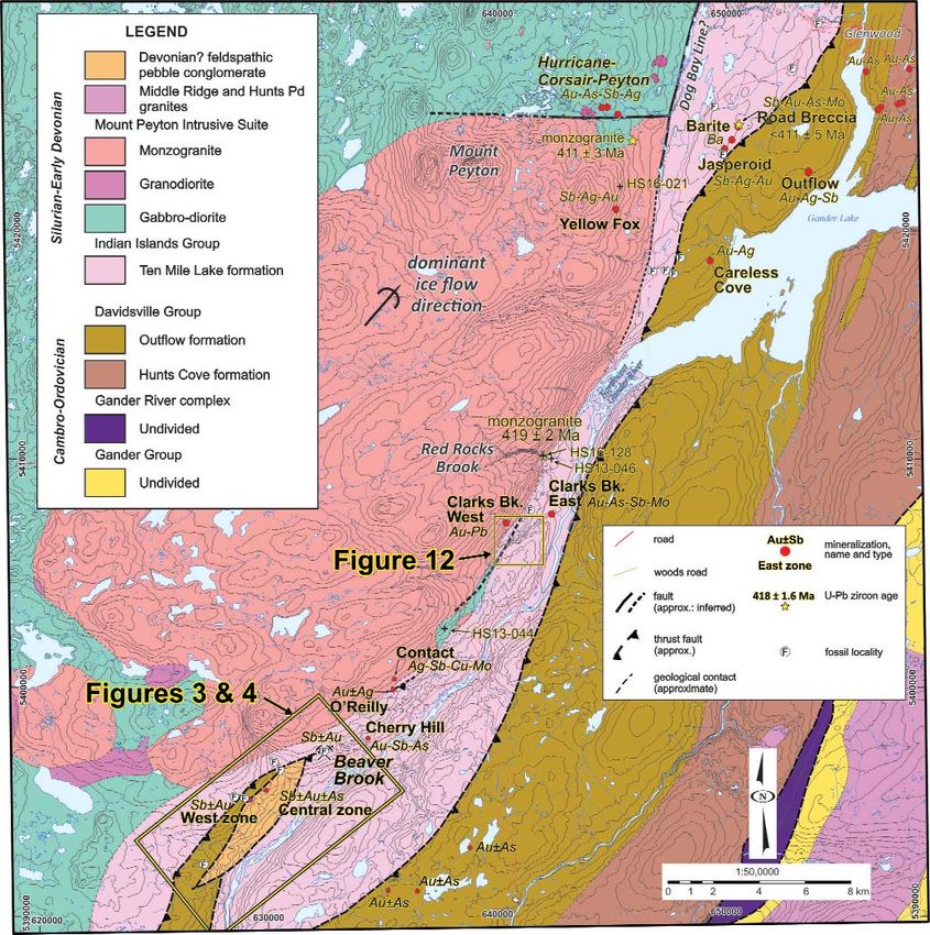
H.A.I. SANDEMAN, C. PEDDLE AND R. NEWMAN

Figure 2. Simplified geological map of central northeastern Newfoundland (http://geoatlas.gov.nl.ca/Default.htm: after
Colman-Sadd et al., 1990 with some adaptations from Dickson, 1996 and Sandeman et al., 2017). Also shown are the loca-
tions of the Beaver Brook Antimony Mine, and other affiliated mineralization (Tallman, 1989a, b; Evans, 1996; Wilton, 2003;
Barbour and Churchill, 2004; O’Reilly and Churchill, 2004; O’Reilly, 2005; O’Reilly et al., 2008, 2010) with respect to major
geological elements of the region.

Sandeman et al., 2017); biostratigraphy (Anderson and            Sandeman et al., 2017) in the greater study area. Also form-
Williams, 1970; Blackwood, 1982; Williams, 1993; Boyce           ing part of the framework for this contribution are the more
et al., 1993; Boyce and Ash, 1994; Williams and Tallman,         detailed mineral deposit studies (O’Driscoll and Wilton,
1995; Boyce and Dickson, 2006; Dickson et al., 2007) and,        2005; O’Reilly, 2005; Squires, 2005; O’Driscoll, 2006;
lithogeochemistry (Dickson, 1996; Dickson and Kerr, 2007;        Lake and Wilton, 2006; Sandmann et al., 2011; Seifert and

                                                                                                                         125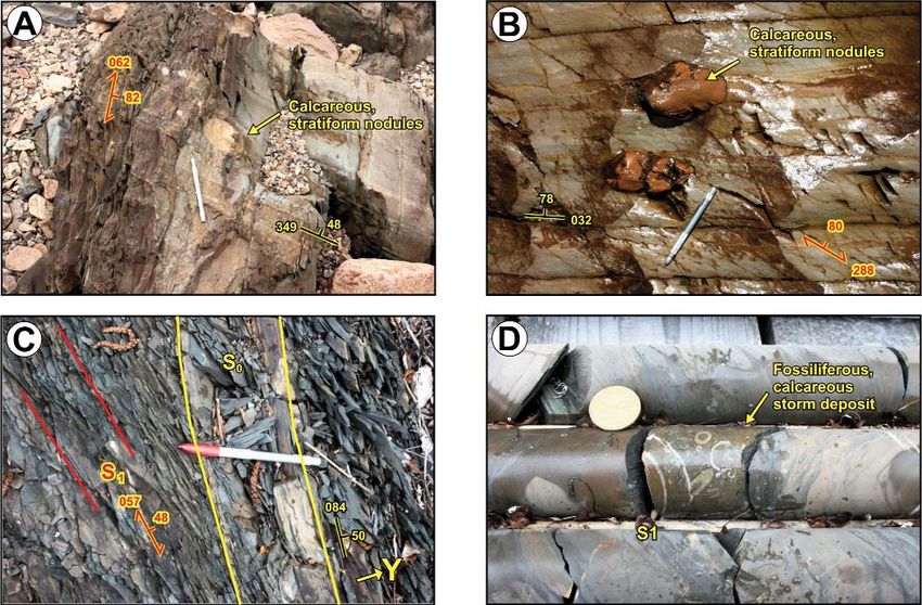
CURRENT RESEARCH, REPORT 18-1

Sandmann, 2013; Sandeman et al., 2017), and numerous              not recorded to the east of the Dog Bay Line. The progres-
mineral exploration industry, assessment work reports that        sive northwest to southeast destruction of these overstep
were submitted to the Government of Newfoundland and              assemblage basins is interpreted to represent the terminal
Labrador over the past three decades. All of these datasets       closure of Iapetus (LaFrance and Williams, 1992; O’Brien,
collectively provide a framework upon which a better              2003). Williams et al. (1993) proposed that the Dog Bay
understanding of the mineralization, as well as the magmat-       Line likely extended south southwestward, inland toward
ic and tectonic history of the region may be constructed.         Glenwood and along the eastern margin of the Mount
                                                                  Peyton intrusive suite.
     Herein, the Beaver Brook Antimony Mine production
and exploration information is updated (see Lake and Wilton,           Subsequent to the historical geological surveys of the
2006), the geological units and their complexity are discussed    late 1800’s and early half of the 20th century, the first mod-
and, a more robust treatment of the structural geology of the     ern mapping of the greater Mount Peyton area was under-
mine area is advanced. This study, in conjunction with ongo-      taken by Anderson and Williams (1970) who produced a
ing investigations (e.g., Sandeman et al., 2017; H. Sandeman,     1:250 000-scale geological map of the western half of the
unpublished data, 2017), attempts to: 1) provide a higher pub-    Gander Lake (NTS 2D) map area. Anderson and Williams
lic profile and a better understanding of the structural geolo-   (op. cit.) recognized that the Beaver Brook Antimony Mine
gy and mineralization at Beaver Brook; 2) emphasize the           area was underlain by a Silurian sequence of shallow-
abundance and diversity of the polymetallic mineralization        marine and terrestrial, reddish sandstones and siltstones
surrounding the mine area, and, 3) stimulate further precious-    (then Botwood Group: see Williams, 1962), that was inter-
metal and antimony exploration in the greater region.             preted to conformably overlie an Ordovician sequence of
Collectively, the new data and interpretations provide better     pebble conglomerate, greywacke and black shale. Those
constraints on the structural setting of the mineralization;      authors considered that this conglomerate–greywacke‒
more clearly refine the probable age of the mineralization to     black-shale sequence “resembled facies of the Goldson con-
the Early Devonian, and suggest a probable genetic link with      glomerate” (now Badger Group, O’Brien, 2003) exposed on
other Au–Ag–Sb–As mineralized zones in the region. Herein,        the northwest coast of Newfoundland near Twillingate.
the time scale used for discussion is the Internation-al          Paleontological studies (L.M. Cumming, 1963, cited in
Chronostratigraphic chart v2017/02 (Cohen et al., 2013;           Anderson and Williams, op. cit.) indicated that rocks of this
http://www.stratigraphy.org/index.php/ics-chart-timescale).       pebble conglomerate–greywacke‒black-shale unit encoun-
                                                                  tered in Cooper Brook (Figure 3) contained both Late
REGIONAL SETTING AND PREVIOUS WORK                                Ordovician and Silurian fauna, and that the rocks therefore
                                                                  represented a sequence transitional between the Ordovician
     The study area lies in the Mount Peyton map area (NTS        turbidites and shales to the southeast and the Silurian, shal-
2D/14), in the eastern Exploits Subzone of the Dunnage            low-marine sandstone and shale of the Botwood Group to
Zone of the Newfoundland Appalachians (Figures 1 and 2).          the west. This Ordovician‒Silurian sequence was therefore
The Exploits Subzone consists of a collage of intra-oceanic       considered to represent a ‘connecting link’ between the
arcs, back-arcs and related marine sedimentary rocks              Gander Group (to the east) and the Baie D’Espoir Group (to
formed in the Iapetus Ocean during the Cambro-Ordovician.         the southwest). Anderson and Williams (op. cit.) also noted
These assemblages were tectonically emplaced eastward             a contact aureole in sedimentary rocks proximal to the
(present-day coordinates) over the Ordovician passive mar-        southeastern Mount Peyton granitoid rocks and indicated
gin sequences of the Gander Zone, during Late Ordovician          that the Silurian rocks of the mine area were disrupted by a
(Penobscott) orogenesis (Colman-Sadd et al., 1990; van            northeast-trending fault.
Staal and Barr, 2012).
                                                                       Blackwood (1980a, b, 1981a, b, 1982) mapped the east-
     The Exploits Subzone is divided into two lithostrati-        ern margin of the Mount Peyton intrusive suite from north
graphic assemblages, separated by the Dog Bay Line, a             of Glenwood, south to the Beaver Brook area. In the mine
major structural feature consisting of shear zones and faults     area, Blackwood (1981a, b) mapped a fault-bound wedge of
and characterized at Dog Bay on the north coast by intense-       fossiliferous (Caradocian; now Sandbian to Early Katian)
ly foliated dark-shale mélange (Williams et al., 1993).           graphitic black shale and greywacke that was inferred to
Cambro-Ordivician rocks of both lithostratigraphic assem-         represent the upper parts of the Davidsville Group as
blages of the Exploits Subzone are overlain by Late               exposed to the north and east (see Kennedy and McGonigal,
Ordovician to Silurian sedimentary units that are interpreted     1972). This unit was mapped as a fault bound sliver
to represent synorogenic overstep assemblages (Williams et        enclosed in a thick sequence of fine- to coarse-grained grey
al., 1988; O’Brien, 2003; van Staal et al., 2014). Volcanic       sandstone, siltstone, shale and calcareous fossiliferous
rocks occur in the overstep sequences to the west, but are        Silurian rocks of the Botwood Group.

126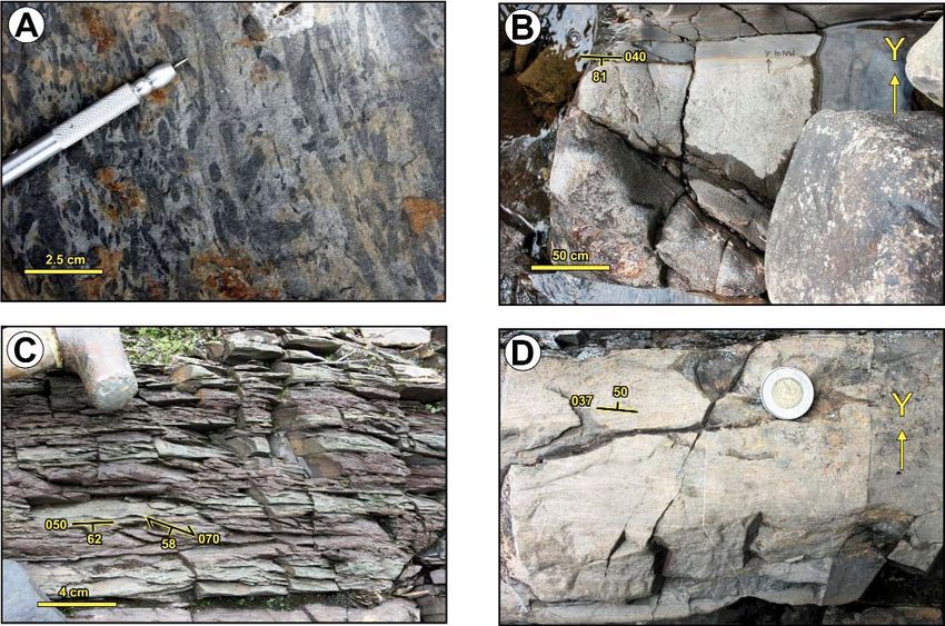
H.A.I. SANDEMAN, C. PEDDLE AND R. NEWMAN

                                  HS13-034                HS13-036
                       57                                    HS13-037
                                        50
                                                    52          HS13-038               A
 53           Beaver                                                                                             0                      1 Km
    95
      00      Brook
         0
                                  West                                             F
                         F        zone                        Central
                  HS16-038                                     zone                         84

              1              70
                                  F     60 HS16-046
                                                         80     54                 F                                            HS15-035

                                                    58           BB-90-04
                                   72
                   2       HS16-079
                           HS16-080            50
                                                           65
                                                                            BB-14-305
                                                                                                 BB-13-273
                                                                                                        BB-13-268          F
                                                    HS15-007
                                                                       24
                                                                                           54
                                                                     82
                                               31
                                                     60
                                                                            HS15-019
                                                                                        B                                       Beaver Brook
                                  CP16-021
                                                                                                            BB-13-292           East zone
                                    HS16-072
                                                                                                               BB-13-259             BB-13-283

                                                                                       Cooper                                               BB-13-287

                       3                                                               Brook

                                                                                                                                                  0
                       00

                                                                                                                                             00
                    00

                                                                                                                                           64
                  63

                                                                                                                                        63
                                                                            LEGEND

             Silurian-Early Devonian                                   West zone
                                                                                       mineralized zone              station
                      Devonian? feldspathic
                      pebble conglomerate                                                                            bedding
                                                                                       woods road
                       Mount Peyton Intrusive                                                                        schistosity
                       Suite (monzogranite)                                            normal fault
                                                                                       (inferred)
                                                                                                                     fold axis (1st generation)
                    Indian Islands Group
                                                                                       thrust fault
                    (and Ten Mile Lake                                                 (approximate)                 quartz vein
                    formation)
                                                                                       geological contact
             Cambrian-Ordovician                                                       (approximate)
                                                                                                                     fracture

                    Davidsville Group
                    (Outflow formation)                                     F          fossil locality

Figure 3. Simplified geological map of the Beaver Brook Antimony Mine area (http://geoatlas.gov.nl.ca/Default.htm) show-
ing the locations of the West, Central and East zones, as well as other sites discussed in the text.

     Additional work in the mine area followed the discov-                         and extended the package of Silurian rocks exposed in the
ery of stibnite-bearing boulders in Beaver Brook and                               Beaver Brook area southwestward to near the Great Bend
includes the initial descriptions of the mineralization at the                     complex (e.g., Donovan et al., 1997). Dickson (op. cit.)
Central zone (Tallman, 1991; Tallman and Evans, 1994),                             noted an abundance of massive to thick-bedded, feldspathic
and the detailed mapping and paleontological investigations                        sandstone, siltstone and pebble conglomerate exposed in
of the local host rocks in Cooper, Beaver and Webber brooks                        and around the Great Bend complex (Figure 1) and inter-
(Figure 3; Williams, 1993; Williams and Tallman, 1995).                            preted these as Devonian rocks. Dickson (1996) similarly
Dickson (1992, 1993) mapped the areas around the south                             recognized an abundance of feldspathic greywacke and peb-
and southeastern parts of the Mount Peyton intrusive suite                         ble conglomerate in the central parts of both Cooper and

                                                                                                                                                      127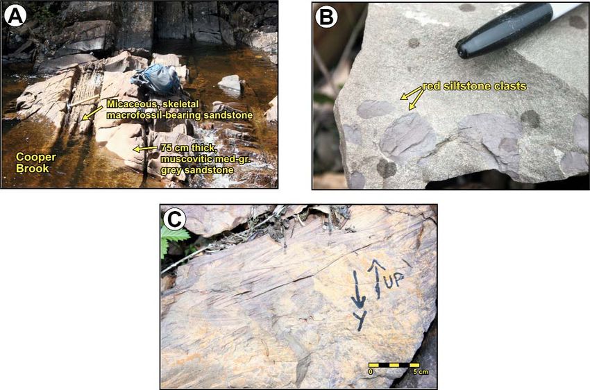
CURRENT RESEARCH, REPORT 18-1
Beaver brooks and re-interpreted the fault-bound wedge of stack (2 on Figure 4) was interpreted to consist of the same
Ordovician rocks as a tripartite wedge of Ordovician, Ordovician lithological units in the same structural repeti-
Silurian and probable Devonian feldspathic conglomerate in tion and order. The oldest inferred unit in imbricate stack 2,
fault contact with both Ordovician rocks of the Davidsville, the southeastward-lying Darriwilian siltstone and sandstone,
as well as Silurian rocks of the Indian Islands groups (Figure is in fault contact with Indian Islands Group siltstone and
2). In order to re-align the major lithostratigraphic units of sandstones lying farther southeast (Figure 4). Unfortunately,
the mine area with the nomenclature proposed by Williams Lake and Wilton (op. cit.) did not present a structural analy-
et al. (1993), Dickson (1996) also indicated that the Silurian sis to substantiate their hypothesis.
strata near the Beaver Brook Antimony Mine likely com-
prises part of the Indian Islands Group, rather than Botwood Many of the previous investigations appear to agree
Group. More recent investigations into the setting of the that the mine area is underlain by faulted, and likely thrust-
antimony deposit and ore genesis at Beaver Brook comprise imbricated, Ordovician and Silurian rocks. However, the
the report of Lake and Wilton (2006), and two conference assignations of the stratigraphic units have changed
abstracts (Sandmann et al., 2011; Seifert and Sandmann, through time and remain problematic. This lithostrati-
2013). Lake and Wilton (2006) outlined and updated mining graphic confusion is, in part, because of the poor exposure
operations and exploration activity since discovery, in the region, but in our opinion, may also be attributed to
described the nature of the mineralization at the three anti- the lithostratigraphic complexities arising through intro-
mony showings, and presented an overview of the host duction of the Dog Bay Line and the geotectonic signifi-
rocks of the mine area including a revised geological map cance of the geological constraints associated with the
(Figure 4), which is significantly different from that of presence of this major structural feature (Currie, 1993;
Dickson (1996). Lake and Wilton (op. cit.) further proposed Williams, 1993; Williams et al., 1993; Pollock et al.,
that the rocks exposed in the mine area form two separate 2007). Thus, the overstep sequences of the Badger and
thrust panels. Their northwestward-lying nappe (1 on Figure Botwood groups are now interpreted to occur only to the
4) consisted of a tripartite sequence of structurally over- northwest, whereas the Davidsville, Hamilton Sound
turned, broadly northwest-younging Ordovician Davidsville (Currie, 1993) and overstep sequence of the Indian Islands
Group rocks comprising Sandbian‒Katian black shale, groups occur only southeast of the Dog Bay Line. The cur-
greywacke and Darriwilian siltstone and sandstone, respec- rent study area and the Beaver Brook Antimony Mine
tively. This nappe was emplaced northwestward over (Figures 2 and 3) occur directly along the proposed south-
Silurian, northwest-younging, structurally overturned Indian western trace of the Dog Bay Line (Currie, 1993;
Islands Group rocks. Their southeastward-lying imbricate Williams, 1993; Williams et al., 1993; Pollock et al.,
o o
48 43’
Cooper 48 43’
58o18’
55o11’
Brook
East
0 km 1 Beaver zone
Brook
85
F
82
F
72
LEGEND
Mount Peyton Intrusive Suite
Central Fine-grained pink biotite granite
F
65 zone Indian Islands Group
Webber
Silurian
Fine-grained, red, crosslaminated sandstone
Brook West Brown-weathering, fine-grained, green-grey
siltstone. Locally contains dolomitic sandstone
74
F zone inclusions and rare fossiliferous debris-flow beds
1 Davidsville Group
Ordovician
Brecciated black chert and shale, locally
contains Katian-Sandbian graptolites
62
2 an
der
Ri
ve
r Hunan pebble greywacke
Thinly bedded fine-grained siltstone. Locally contains
Dariwillian graptolites
t G
w es bedding
woods road
rth
No fault cleavage
thrust fault F fossil locality
58o18’
geological contact
(approximate) thrust panel number
48o43’
1 (see text)
Figure 4. Geological map of the Beaver Brook Antimony Mine area after Lake and Wilton (2006).
128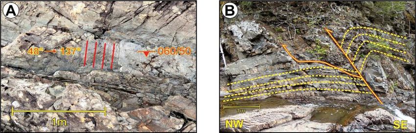
H.A.I. SANDEMAN, C. PEDDLE AND R. NEWMAN

2007), but the location of this major strike-slip dextral         owned company Hunan Nonferrous Metals (HNC) pur-
fault in the mine area, and along the eastern margin of the       chased the operation. At the end of 2009, China Minmetals
Mount Peyton intrusive suite, is presently unknown.               Corporation, China’s biggest metal trader, acquired 51%
                                                                  equity of Hunan Holdings Group (HNG), the state-owned
EXPLORATION HISTORY                                               parent of HNC. The Beaver Brook Antimony Mine returned
                                                                  to full production in the summer of 2010 and continued to
     In the mine area (Figures 2 and 3), the earliest explo-      operate until November 20, 2012, when it went into care and
ration work was undertaken by the Noranda‒Noront Grub             maintenance. Nine employees presently ensure the property
Line Syndicate between 1989 and 1995. During that time            is kept in good condition and meets all government require-
they discovered three, antimony-mineralized zones occur-          ments. The underground workings are kept dewatered for a
ring along a northeast‒southwest (065°) trend. At the time of     smooth restart when economic conditions improve. Table 1
discovery, these were termed, from southwest‒northeast, the       shows the mines production statistics from 2008 to 2012.
Xingchang, Hunan and Szechuan
showings (Tallman, 1989a), after          Table 1. Table documenting Beaver Brook Antimony Mine production statistics dur-
the major antimony-producing              ing the five years of operation from 2008 to 2012
regions of China. For simplicity,
however, the mineralized zones                                              2008    2009      2010      2011     2012      Total
were renamed the West, Central
and East zones, respectively              Tonnes Milled DMT               73 710 83 524 137 355 162 598 142 105 599 283
(Bourgoin, 1993). Early explo-            Head Grade %                       3.40    4.47      4.23      3.19     2.63       3.5
ration results of soil sample and         Concentrate Produced DMT          3492    5595      8945      8061     5814 31 906
ground magnetic and VLF geo-              Metal Produced DMT                2219    3593      5578      4958     3554 19 902
physical surveys indicated that the
mineralized trend was transected          DMT - dry metric tonnes
by at least 2, and perhaps 3,
east‒west-trending, dextral fault zones, which were inferred              Exploration programs were carried out from 2009 to
to offset the stratigraphy by 200 to 500 m (Tallman, 1989a;          2015, inclusively. A 70.5-line-km cut grid was established
Tallman and Evans, 1994). The existence of these purported           across the property and two induced polarity (IP) surveys
east‒west faults has not yet been demonstrated.                      (shallow/deep) were completed over the grid. Although the
                                                                     surveys were unsuccessful in outlining mineralized zones,
     Significant antimony mineralization was first discov-           they provided clear evidence for a number of abrupt breaks
ered at surface and drilled at the Central zone (Figures 3 and       in zones of anomalous chargeability that corresponded to
4), but further exploration and drilling at the East zone            known graphitic shale horizons (Reeves, 2009). More than
resulted in the eventual delineation of a resource of 2.2 mil-       4000 soil samples were collected (Newman, 2012) and a
lion tonnes of ore grading 3.99% Sb, at a 1.5% cut off               number of new Sb- and Au- in-soil anomalies were identi-
(Morrissy and House, 1998). In all three zones, the ore is           fied ~800 m southwest of the West zone. The Au-in-soil
interpreted to be hosted in the hanging wall of a ~065°-             anomalies clustered to the south and southwest of the Sb
trending fault zone inferred to represent a regional thrust          anomalies. A total of 124 diamond-drill holes have been
(Morrissy and House, 1998; House, 1999; Newman, 2012).               completed since 2008, bringing the mine lease total to 315.
The Beaver Brook Antimony Mine has changed ownership                 Prior to 2013, drilling was focused on down-dip expansion
several times since original discovery in 1989. The early            of the East zone, but subsequently (from 2013 to 2015), the
exploration history at Beaver Brook has been further out-            focus changed to exploration of the area between the East
lined and discussed in detail by Lake and Wilton (2006 and           and Central zones. Nineteen diamond-drill holes have been
references therein). Below we outline the activity on the            completed on a new target discovered in 2013, approxi-
mine lease since 2006.                                               mately 300 m northeast from the Central zone. A number of
                                                                     these step-out holes (see Figure 3) intersected Sb, Au–As
     Although Roycefield Resources Ltd. brought the mine             and Sb–Au–As mineralized zones. Diamond-drill hole BB-
into production in 1997 (Morrissy, 1997; Morrissy and                13-259 intercepted 3 m @ 3.79 g/t Au at 372‒375 m depth
House, 1998; House, 1999), it only operated for 8 months             and DDH BB13-287 intercepted 2.1 m @ 3.8 g/t Au at
because of a precipitous drop in global antimony price               66.5‒68.6 m depth. Similarly, DDH BB13-268 cut 5.5 m @
(~US$5000/metric ton in 1995 versus ~US$1500/metric ton              2.11 % Sb at 63.5‒69 m depth and DDH BB-13-292 cut 8
in 1997: Butterman and Carlin, 2004). Canadian Antimony              m of 3.0% Sb at 380.7‒388.7 m depth. Of particular note,
Mine reopened the mine in 2008. In 2009, the Chinese-                brecciated and altered greywacke at a depth of 221 m in

                                                                                                                            129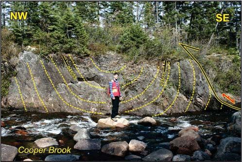
CURRENT RESEARCH, REPORT 18-1

DDH BB-14-305 yielded an assay of 7.01% Sb with 6.3 g/t           rocks of the Ordovician Davidsville (Kennedy and
Au over a 5.05 m interval (Figure 3). Two drillholes to the       McGonigal, 1972; Blackwood, 1981a, b; O’Neill and
southwest of the West zone provide lithostratigraphic infor-      Blackwood, 1989) and Silurian Indian Islands (Williams et
mation but did not intersect mineralization.                      al., 1993; Dickson, 1993, 1996) groups of the eastern
                                                                  Exploits Subzone, as well as granitoid rocks of the Mount
     Based on a Geo Stat International Inc. technical report      Peyton intrusive suite (Blackwood, 1982). The nomencla-
(Reeves, 2009), the total indicated resources at the East         ture of the granitoid rocks follows that of Dickson (1996)
zone deposit, prior to restarting of the mine, was 1 062 600      with the additions from Dickson and Kerr (2007) and
tonnes @ 5.15% Sb (Reeves, 2009). Based on an internal            Sandeman et al. (2017). A suite of young, mafic dykes that
resource calculation (Beaver Brook Antimony Mine, inter-          cut both rocks of the Indian Islands Group and the Mount
nal report, 2013) a total of 533 370 tonnes @ 4.17% Sb            Peyton intrusive suite are also recognized. Below, the diffi-
remains at the East zone. Resources at the Central zone           culty in the correct assignation of the rocks is emphasized in
were determined to include 154 570 tonnes of ore at 5.62%         the light of the current nomenclature and geological maps. A
Sb (Reeves, 2009); however, this does not include the             preliminary geological map and cross section for a Cooper
results from the 2008‒ 2013 exploration drilling. The cur-        Brook transect are presented, whereas similar transects for
rent reserves at the East zone are based on a plan to contin-     Beaver and Webber brooks and an updated geological map
ue mining upward from the bottom of the mine (9660                of the area have as yet not been completed.
level), to the 9800 level, and finish with the recovery of the
crown pillar at surface (9950 level).                             ORDOVICIAN ROCKS: DAVIDSVILLE GROUP

       GEOLOGY OF THE MINE AREA                                         The oldest rocks of the study area (Unit 1, Figures 5 and
                                                                  6) consist of dark-green to grey-black, well-cleaved siltstone
     As stated earlier, the lack of exposed bedrock and the       and less common fine-grained sandstone (Plate 1A, B), which
widespread presence of thick fluvioglacial deposits are the       crop out in the middle sections of Cooper Brook (Figures 3 to
major stumbling blocks for obtaining a better understanding       6). These rocks are typically strongly cleaved, folded and
of the geology of the Beaver Brook Antimony Mine area.            locally form mullions (Plate 1A, B). The graptolite fauna,
The only exposures consist of either northwest‒southeast-         Aulograptus cf. cucullus and Undulograptus primus
oriented, partially exposed stream-bed sections, or anthro-       (Williams and Tallman, 1995), is locally recognized in areas
pogenic disturbances of the surficial deposits such as roads,     of lower strain rocks (e.g., Figure 5: station HS15-051,
trenches or road materials quarries. A survey of the depth-to-    630574E, 5396326N), and indicative of a Darriwilian, Middle
initial-bedrock in 139 of the 315 diamond-drill holes indi-       Ordovician age (Williams and Tallman, 1995; Bergström et
cates that the fluvioglacial deposits range in thickness from     al., 2009), comparable to faunal assemblages described from
2.3 to 29.2 m (average depth = 7.7 m), a clear reason why         the Davidsville Group near Glenwood (Williams, 1969;
few exploration trenches have succeeded in exposing               Anderson and Williams, 1970; Blackwood, 1982).
bedrock. To better constrain the geological and structural
setting of the mineralization at Beaver Brook, this project            Unit 2 (Figure 5), referred to as the Hunan greywacke
includes construction of a geological database for the region     (Tallman, 1989a; Tallman and Evans, 1994; Lake and
(Figure 2) comprising: 1) ~150 regional outcrops, including       Wilton, 2006), occurs throughout the central part of the
multiple structural observations per station; 2) detailed trav-   mine area and in the middle sections of Cooper Brook
erses along with a high density of stations and structural        (Figures 3 to 6). Greywacke is typically black to dark brown
measurements along four streams in the region, including          but locally grey, massive and thickly bedded (Plate 1C) con-
the Cooper, Beaver and Webber brooks (Figures 3 and 4)            taining abundant quartz, plagioclase and common mafic vol-
and one on Clarks Brook (13 km to the north northeast,            canic clasts and pebbles. Other lithic clasts include dark-
Figure 2); 3) examination of 139 diamond-drill holes and          shale, fine-grained sandstone, siltstone and felsic volcanic
their first bedrock intercepts; 4) a compilation of biostrati-    clasts. Greywacke is locally interbedded on
H.A.I. SANDEMAN, C. PEDDLE AND R. NEWMAN
ing, quartz ± stibnite–carbonate veins (Plate 1D). Tallman over 1.6 m. Intersections in drillcore (e.g., Figure 3: DDH
(1989, 1990) reported that the main stibnite mineralization BH90-04_41.8-49.03 m) yielded similar quartz–stibnite
at the Central zone consisted of a ≤1.6-m-wide zone of veins and vein breccias yielding up to 8.99% Sb over 7.23
quartz‒stibnite veins and vein breccia on the north side of m (Tallman, 1990). In a number of DDH that penetrated the
the large trench (now mainly water filled: see Plate 13 in mineralized Central zone, the greywacke structurally over-
Squires, 2005). Channel samples yielded up to 30.4% Sb lies grey siltstone and black shale.
o o
48 43’ 48 43’
630000 631000
55o14’
55o12’
HS15-039 A LEGEND
Quaternary: till and fluvial deposits
Fine- to medium-grained miarolitic
7 monzogranite
Thick-bedded, grey-maroon muscovitic
Silurian
5 sandstone and minor siltstone
Approximate projected Thin-bedded, grey-maroon muscovitic
contact of Units 5 and 7 4 sandstone and siltstone
3 Brecciated and folded black shale
Ordovician
5397000
Black-brown greywacke and pebbly
2 sandstone
Green-grey to black graptolitic
1 siltstone-sandstone
3 Thrust nappe (in text)
71
42 F fossil locality
20
68
Plate 3C
75
HS15-026 82 75
probable Silurian F 86 Plate 2A
crinoids, corals, HS15-046
87
and bryozoa lt
84 fau
HS15-025: Plate 3A
h r ust
86 T
72
74
Plate 1C
1
79
HS15-021
59
ult
71
85
a l fa inferred
ine
site
Darriwillian graptolites 64
rm “Sb-mineralized” To M
HS15-051
F 75 No 5/70° lt fault
fau
82
06
78
r u st
70
Th
F s)
ole
63
probable Silurian crinoids 71
r i llh
and corals HS16-015 d BB-13-273
m
d fro
fe rre metres
lt (in 0 50 100 150 200 250
t fau
rus
5396000
2 Th
42
51 46
Plate 2C
50
65
HS13-041
54
60
65
70 010
3 Plate 4
B HS15-019
55o14’
55o12’
48o42’ BB-14-305 48o42’
Figure 5. Simplified geological map of Cooper Brook. The locations of thrust and normal faults, significant localities men-
tioned in text including biostratigraphic control horizons and noteworthy rock types and structures are also noted. Modified
after Blackwood (1981b); Tallman (1991); Tallman and Evans (1994); Dickson (1993, 1996) and Lake and Wilton (2006).
131CURRENT RESEARCH, REPORT 18-1
NW SE
1 2 3
A B
? ?
H=V
~250m
LEGEND
Quaternary: till and fluvial deposits normal fault
Fine- to medium-grained miarolitic
7 monzogranite synform
Thick-bedded, grey-maroon muscovitic
Silurian
5 sandstone and minor siltstone
Thin-bedded, grey-maroon muscovitic antiform
4 sandstone and siltstone
3 Brecciated and folded black shale thrust (inferred)
Ordovician
Black-brown greywacke and pebbly
2 sandstone
thrust (defined)
Green-grey to black graptolitic
1 siltstone-sandstone
Figure 6. Schematic geological cross-section through Cooper Brook.
Structurally below the wacke–siltstone–sandstone SILURIAN SEDIMENTARY ROCKS: INDIAN
sequence is a relatively narrow (≤50 m), brecciated, mul- ISLANDS GROUP AND TEN MILE LAKE
lioned and chaotically folded sequence of graphitic black FORMATION
shale (Unit 3; Plate 1E) that is exposed in two localities in
Cooper Brook (Figures 5 and 6). In Beaver Brook, similar, All rocks lying to the west of the continuously exposed,
strongly cleaved, graphitic black shale was reported by north-northeast–south-southwest-trending belt of Ordo-
Blackwood (1982) and confirmed by Williams and vician rocks of the Davidsville Group, and east of the Mount
Tallman (1995) to contain the graptolite assemblage Peyton intrusive suite (Figure 2) are inferred (see Dickson,
Pseudoclimacograptus scharenbergi, Climacograptus? 1996; Dickson et al., 2007; Barbour and Churchill, 2004;
brevis and Corynoides calicularis indicating a Middle Lake and Wilton, 2006; O’Reilly et al., 2010) to comprise
Ordovician, Sandbian to early Katian age (Bergström et part of the Silurian Indian Islands Group (Williams et al.,
al., 2009). The Ordovician sequences of the area either 1993) or Ten Mile Lake formation (Currie, 1993; Williams
represent a telescoped, 30 M.y. depositional interval (i.e., et al., 1993; Dickson, 1996, 2006; Dickson et al., 2007). A
Darriwilian to Katian) or, alternatively, two temporally and diagnostic feature of both of these units is common detrital
lithostratigraphically distinct, Ordovician, sandstone–silt- muscovite in the sandy beds. Moreover, in the mine area,
stone ± shale ± greywacke sequences. The graptolitic black and particularly to the west-northwest of the mine site, these
shale occurs as the basal unit of a number of the mapped units weather orange to tan, commonly have a thick-weath-
thrust panels and is a critical, easily recognized marker ering rind interpreted to be related to their carbonate-rich
horizon in diamond-drill core (Plate 1F). All of these rock composition.
types (Units 1 to 3) are inferred to collectively comprise
the Outflow formation of the Davidsville Group (O’Neill The most extensive unit in the mine area (Unit 4, Figure
and Blackwood, 1989). 5) typically consists of 2‒20-cm-thick interbedded, medium-
132H.A.I. SANDEMAN, C. PEDDLE AND R. NEWMAN
Plate 1. Photos of representative rock types inferred to comprise the Davidsville Group in the mine area. A) Graptolitic, fold-
ed and cleaved, grey‒black siltstone and sandstone in Cooper Brook viewed looking southwest (Figure 3: station HS15-051);
B) Close-up of A, pen is 15 cm in length; C) Massive, brown-black pebble greywacke exposed in Cooper Brook (Figure 5: sta-
tion HS15-021). Pen magnet is 16 cm in length; D) Locally quartz-veined, sericitized and silicified pebble wacke exposed in
the main trench at the Central zone (Figure 3: station HS15-007). Pen magnet is 16 cm in length; E) Brecciated and chaoti-
cally folded graphitic black shale exposed in Beaver Brook (Figure 3: station HS16-046). Red lines highlight anastomosing
cleavage. Geotul is 73 cm in length; F) Brecciated and chaotically folded graphitic black shale noted in diamond-drill core
(Figures 3 and 5: DDH BB13-273_108m).
133CURRENT RESEARCH, REPORT 18-1 grey to locally green and maroon, siltstone and shale and sected at least fifteen examples of thin, shelly fossil-bearing, fine-grained muscovitic sandstone in varying proportions calcareous debris flows in interbedded sandstone and silt- (Plate 2A‒C). A characteristic feature of Unit 4 in the mine stone of the Charles Cove formation that also commonly area is the occurrence of discontinuous, bedding-parallel, exhibits soft-sediment deformation features (Plate 2D). orange dolomitic sandstone beds that locally either pinch- and-swell, abruptly terminate, or form stratiform lenses and In the mine area, Unit 5 (Figure 5) is only exposed along nodules (Plate 2A, B). These likely represent in-situ diage- the eastern margin of the Mount Peyton intrusive suite in the netic replacement deposits of primary features. Unit 4 is upper sections of Cooper Brook, and near the Beaver Brook inferred to correlate with the Charles Cove formation of the Antimony Mine tailings ponds. It typically consists of mas- Indian Islands Group, exposed along the Gander Bay coast sive, weakly cleaved, medium-grey, fine- to medium-grained (Williams et al., 1993; Dickson, 2006; Boyce and Dickson, muscovitic sandstone having ≥20-cm-thick beds having thin 2006; Dickson et al., 2007). The siltstone–shale layers in (≤5 cm) and less common siltstone beds. Locally, these rocks Unit 4 are typically well cleaved and exhibit consistent bed- contain
H.A.I. SANDEMAN, C. PEDDLE AND R. NEWMAN

Plate 3. Photographs of representative features of rocks that are inferred to comprise the Ten Mile Lake formation in the mine
area. A) 10-cm- to 1-m-thick beds of muscovitic fine-grained grey sandstone and siltstone interbedded with calcareous strat-
iform sandstone horizons in Cooper Brook (Figure 5: HS15-025; UTM’s – 630430E, 5396640N). Geotul is 58 cm in length;
B) Fine-grained maroon to tan muscovitic sandstone with subrounded red-maroon siltstone clasts (Figure 3: station HS15-
035; UTM’s – 631968E, 5397499N). Marker top is 5 cm in length; C) Section view looking northwest at overturned trough
crossbedding in medium-grained maroon to tan muscovitic sandstone in Cooper Brook (Figure 5: station HS15-026; UTM’s
– 630201E, 5396779N).

beds having abundant, angular red siltstone clasts (Figure 4:    includes significant localities mentioned in the text. Figure
Plate 3B, station HS15-035). These clasts strongly resemble      6 is a schematic geological cross-section derived from
maroon siltstone of Unit 4 that is commonly observed in          Figure 5. In the northwest (A), fine- to medium-grained,
drillcore and exposed in Beaver and Cooper brooks. Trough        miarolitic and granophyric monzogranite (Unit 7: Figures 5
crossbedding is relatively common and locally indicates both     and 6) is exposed immediately southwest of Cooper Brook.
right-way-up and overturned stratigraphy (Figure 4: Plate        This monzogranite is characterized by spaced (~20 cm)
3C, station HS15-027). Rocks of Unit 5 are less common           northeast-trending and steeply to moderately southeast-dip-
than those of Unit 4, appear to be terrestrial to shallow        ping fractures. Approximately 600 m downstream from sta-
marine, and are inferred to correlate with the reddish, domi-    tion HS15-039 (Figure 5), the first exposures consist of
nantly terrestrial muscovitic sandstone of the Ten Mile Lake     massive, weakly cleaved, medium-grey, fine- to medium-
formation exposed to the north along the Dog Bay Line            grained muscovitic sandstone, less-common siltstone beds
(Currie, 1993; Williams et al., 1993).                           and calcareous shelly fossil debris flows of Unit 5 (e.g.,
                                                                 Figure 5: Plate 3A, station HS15-025). These rocks are
                 Cooper Brook Transect                           tightly folded, as indicated by overturned bedding and vari-
                                                                 able bedding orientations, and extend ~350 m to the south-
     Figure 5 represents a simplified, new geological inter-     east of the Quaternary-covered interval. Unit 5 is in rela-
pretation (this study) of a transect along Cooper Brook, and     tively abrupt contact, along a steeply dipping surface, with

                                                                                                                          135
CURRENT RESEARCH, REPORT 18-1 ~100 m of moderately cleaved and interbedded, medium- grey to locally green, siltstone and fine-grained muscovitic sandstone in varying proportions (i.e., Unit 4: e.g., Plate 2A‒C). These rocks are structurally overlain by a ~70° south-dipping, 20-m-thick panel of intensely sheared, brec- ciated and lineated black graphitic shale of Unit 3 (Figure 5). The incompetence and structural complexity of the black shale suggests that this unit has preferentially focussed structural slip and represents a significant thrust surface (base of thrust panel 1: Figures 5 and 6). Structurally above the black shale is a 40-m-thick panel of strongly cleaved grey to black siltstone and sandstone (Unit 1) overlain by a 100-m-thick sequence of dominantly peb- ble greywacke and minor sandstone of Unit 2 (e.g., Figure 5: Plate 1C, station HS15-021). The greywacke is overlain Plate 4. A closed, >10 m wavelength upright to weakly to the southeast by a second, ~125-m-thick panel of strong- northwest-vergent F1 syncline of grey sandstone and silt- ly cleaved grey to black siltstone and sandstone that con- stone of the Indian Islands Group in Cooper Brook below tains Darriwilian graptolites (e.g., Figure 5: Plate 1A, sta- the road bridge (Figure 5: station HS15-019). Yellow lines tion HS15-051). The graptolitic shale is bound to the south- trace bedding. Note that the southeastern fold limb is trun- east by a steeply southeast-dipping normal fault that places cated by a thrust. a ~60-m-thick panel of locally crinoid-bearing, medium- grey to locally green, siltstone and fine-grained muscovitic cates that intraformational thrusting may be more promi- sandstone of Unit 4, northwestward over the graptolite- nent in the area than presently recognized. bearing Ordovician sequence. This package of black shale, grey-black siltstone, sandstone and greywacke as well as Beaver Brook Transect the 60-m-thick slice of Unit 4, is herein interpreted to con- stitute thrust panel 1 (Figures 5 and 6). After a 10 m cov- Mapping and interpretation of the units in Beaver ered interval, the next rock-type exposed to the southeast is Brook are more difficult, owing to an apparently more rapid a ~60-m-thick sequence of chaotically folded and brecciat- and progressive change in rock type, greater variations in ed black shale of Unit 3. Although the contact is not lithofacies and bed thicknesses and, the resultant inherent exposed, the black shale horizon is interpreted to represent problems with assigning lithostratigraphic names. the base of a second prominent thrust panel (thrust panel 2, Nevertheless, the approximate traces of two thrust faults Figures 5 and 6). The next ~225 m downstream is covered were confirmed; however, the trace of a third indicated, by coarse fluvial gravels with no exposure. Numerous dia- southeastward-lying fault (e.g., Figures 3 and 4), is in an mond-drill holes collared near the adjacent woods road area of no exposure. A different thrust fault was noted to (e.g., DDH BB-13-273; Figures 3 and 5) and oriented along transect rocks near the south easternmost exposures in an azimuth of 340°, initially intersected rocks of Unit 4, but Beaver Brook (Figure 3, station HS16-072), where strongly consistently intersected a third brecciated black shale hori- cleaved, grey-green sandstone and siltstone (inferred zon at depth. This third black shale horizon is interpreted as Davidsville Unit 1) are emplaced north westwards over a thrust fault and is projected to surface in Figure 5. Like moderately cleaved grey calcareous sandstone and siltstone the other two brecciated black shale horizons, the base of inferred to represent rocks of the Indian Islands Group the third brecciated black shale horizon is interpreted to (inferred Unit 4). mark a prominent regional thrust fault. The remaining downstream exposures on Cooper Brook consist of ~300 m The westernmost outcrop exposed in Beaver Brook of moderately cleaved, southeast-dipping and tightly to consists of thick-bedded sandstone to pebbly sandstone that openly folded, interbedded, medium-grey to locally green locally appears to contain shelly fossil debris, and is inter- and maroon, siltstone and fine-grained muscovitic sand- preted to be part of Unit 5, the Ten Mile Lake formation. stone of Unit 4, which likely forms most of the third thrust After a covered interval of ~30 m, the next exposures con- panel (thrust panel 3: Figures 5 and 6). At the extreme sist of a ~500-m-thick sequence consisting of strongly southeast of the transect (near B in Figure 5), the upper cleaved, fine-grained grey-black shale and buff, fine- limb of a closed, gently northeast-plunging, northwest grained sandstone containing grey-black shale clasts (Plate verging synform with shale and sandstone of Unit 4 is trun- 5A). These rocks are locally interbedded with both right- cated by a northwest-directed thrust fault (Figure 5; Plate way-up, and overturned, graded greywacke beds (Plate 5B). 4). This last exposure at station HS15-019 (Figure 5) indi- Brecciated, strongly cleaved and chaotically folded black 136
H.A.I. SANDEMAN, C. PEDDLE AND R. NEWMAN

Plate 5. Photographs of representative units exposed along Beaver Brook. A) Relatively massive, fine-grained grey sandstone
having abundant black siltstone rip-up clasts in the upper section of Beaver Brook (station HS16-034: 15 m west of HS16-
038 on Figure 3); B) Overturned graded bedding in pebble to sandy greywacke interbedded with grey‒black siltstone (Figure
3: station HS16-038); C) A 2-cm-scale interbedded maroon and medium-grey siltstone exposed in the middle section of the
brook (Figure 3: station HS16-079); D) A 15-cm-thick, crossbedded fine-grained sandstone (Figure 3: station HS16-080).

graphitic shale occurs, locally, throughout, and in particular,   Cove formation of the Indian Islands Group (after Currie,
near station HS16-046 (Figure 3), where it forms the struc-       1993; Williams et al., 1993). Both Beaver and Webber
turally highest unit in thrust panel 1. Thus, these rocks         brooks will be revisited during future field work.
(Units 1 to 3) collectively comprise the stratigraphy lying
between the thrust faults labelled 1 and 2 (Figure 3).                                  Intrusive Rocks

     Between faults 2 and 3 (Figure 3), and including what              Granitoid rocks of the Mount Peyton intrusive suite
was interpreted by Dickson (1996) as Devonian rocks, the          (Anderson and Williams, 1970; Strong, 1979; Blackwood,
sedimentary units comprise a folded, variably cleaved             1982; Strong and Dupuy, 1982; Dickson, 1992; 1996) dom-
sequence of alternating thin- and thick-bedded, medium-           inate in the west of the map area (Figure 2). There, the intru-
grey sandstone and siltstone, and maroon and green-grey           sive suite consists of two main rock types. The oldest, Unit
sandstone, siltstone and pebbly sandstone (Plate 5C) locally      6 (not shown on Figure 5), outcrops infrequently along the
with clear younging indicators (Plate 5D). These units form       eastern margin of the Mount Peyton intrusive suite and con-
the bulk of what was interpreted by Dickson (1993, 1996) as       sists of fine- to, locally, medium-grained, ilmenite–mag-
a poorly bedded Devonian(?) sandstone–conglomerate                netite–hornblende ± biotite gabbro grading to diorite (Figure
sequence, but interpreted by Lake and Wilton (2006) as            2: Plate 6A, station HS13-044). The second rock type, Unit
comprising Ordovician rocks of their thrust nappe #2              7, consists of fine- to medium-grained and typically miaro-
(Figure 4). The rocks lying east of thrust fault 2 are herein     litic, magnetite‒ilmenite‒biotite ± hornblende granophyric-
interpreted to be lithofacies representatives of the Charles      textured monzogranite (Plate 6B).

                                                                                                                             137
CURRENT RESEARCH, REPORT 18-1 Plate 6. Photographs of representative features of intrusive rocks and contact relationships along the eastern margin of the Mount Peyton intrusive suite. A) Medium-grained ilmenite–magnetite–biotite–hornblende diorite with diffuse gabbro enclaves exposed ~8 km north of the mine site (Figure 2: station HS13-044: UTM’s – 637663E, 5402522N); B) Fine- to medium- grained magnetite–biotite–hornblende monzogranite with diffuse diorite enclaves exposed in the new road quarry northwest of the mine site (Figure 3: HS13-034; UTM’s 628517E, 5396555N); C) Centimetre-scale miarolitic cavity in fine- to medium- grained monzogranite exposed southwest of the mine site (Figure 3: station HS13-037; UTM’s – 628745E, 5396604N); D) Dark-grey to black, 2- to 15-cm-thick-bedded fine-grained sandstone and siltstone within a few metres of the contact with the monzogranite (Figure 3: station HS13-036; UTM’s – 628643E, 5396559N); E) A 3-cm-wide dyke of fine-grained monzo- granite cuts southeast-dipping dark-grey to black, fine-grained sandstone and siltstone (Figure 3: station HS13-037; UTM’s – 628745E, 5396604N). It is not clear from field observations to which lithostratigraphic unit these hornfelsed rocks belong; F) Pervasive, spaced fracture S1 cleavage (~20 cm spacing) developed in the Mount Peyton granite immediately west of the contact with the Indian Islands Group in Red Rocks Brook (Figure 2: station HS16-128: UTM’s – 642027E, 5410106N). Photograph looking north. The cleavage has a mean orientation of 035/60°. 138
H.A.I. SANDEMAN, C. PEDDLE AND R. NEWMAN

     Smaller stocks of medium-grained biotite granodiorite       Mine. Gabbro dykes and sills are also described from a
occur (Strong, 1979; Strong and Dupuy, 1982; Dickson,            number of examples of auriferous mineralized zones along
1996), but were not noted in the present study. The monzo-       the Dog Bay Line including the Road Breccia showing
granite cuts the gabbro‒diorite as net veins (see Dickson et     (Figure 2: Squires, 2005; McNicoll et al., 2006), Big
al., 2007; Sandeman et al., 2017) and near the mine area,        Pond‒Blue Peter prospect (Evans, 1996) and, the Titan,
monzogranite locally contains abundant, dispersed and dif-       Flirt, Corvette and Goldstash prospects farther north near
fuse enclaves of fine-grained diorite (Plate 6B). The diffuse    the Gander Bay coast (Churchill and Evans, 1992; Churchill
character and abundant acicular apatite grains in the diorite    et al., 1993; Squires, 2005; McNicoll et al., 2006). A mafic
enclaves, suggest hybridization between the two magmas           dyke that cuts sandstone and siltstone of the Indian Islands
(Wylie et al., 1962; Perugrini and Poli, 2012). The intrusive    Group in drillcore at Beaver Brook Antimony Mine (Figure
rocks in the immediate mine area are exclusively fine- to        3: DDH BB13-292_434.5 m), a mafic dyke that cuts mon-
medium-grained miarolitic monzogranite (Plate 6C), locally       zogranite of the Mount Peyton intrusive suite (Figure 2: sta-
with diorite enclaves, and commonly containing numerous,         tion HS16-21B) and, a mafic dyke that cuts Unit 4 of the
variously spaced, manganese-coated fractures, and wide-          Indian Islands Group (Figure 12: station CP16-080B) were
spread orange‒yellow siderite‒limonite staining.                 petrographically examined and analyzed for their lithogeo-
                                                                 chemical compositions. Two of the three dykes are olivine +
     The contact between the Mount Peyton intrusive suite        clinopyroxene porphyritic, whereas the third is fine grained
and the surrounding country rocks is rarely exposed and has      having extensively altered primary phases. All three sam-
been variably interpreted as being faulted (Barbour and          ples, however, have bulk-rock compositions of alkaline lam-
Churchill, 2004; Squires, 2005), and intrusive (Dickson,         prophyres and, are interpreted to likely be associated with
1993, 1996; Barbour and Churchill, 2004; Lake and Wilton,        either the Dildo Pond, or Budgells Harbour pyroxenite intru-
2006). Examination of a number of exposures proximal to          sions (Strong and Harris, 1974) on the northern coast of the
the contact indicate that both of these observations are like-   island, as suggested by Strong and Dupuy (1982) and
ly correct, depending upon the location along the eastern        Dickson (1993).
margin of the Mount Peyton intrusive suite (Figure 2). A
new road-materials quarry and its access road, 4 km west of          REGIONAL GEOCHRONOLOGICAL
the Beaver Brook Antimony Mine (Figure 3: station HS13-
037), expose the contact between miarolitic monzogranite
                                                                            CONSTRAINTS
and a sequence of cm- to dm-thick beds of grey-weathering,
glassy black, hornfelsed siltstone and fine-grained sandstone         Although the ore at Beaver Brook has not been directly
(Plate 6D) lacking a regional foliation. Narrow (≤20 cm),        dated, a number of lines of evidence, including regional geo-
broadly east-trending veins and dykes of massive, fine- to       logical, paleontological and sparse U–Pb geochronological
medium-grained biotite monzogranite (Plate 6E) cut the tilt-     data, help constrain the age and the nature of the mineraliz-
ed (and folded?) sedimentary rocks that have bedding trend-      ing environment. These data are summarized in Figure 7.
ing 065/55°. Younging directions could not be determined.        The most recent mapping (Dickson, 1996; Lake and Wilton,
                                                                 2006) proposed that the host rocks of the stibnite mineral-
     In Red Rocks Brook, approximately 16 km to the north-       ization comprise two distinct lithological units, the
northeast of the Beaver Brook Mine, (Figure 2), 5- to 10-        Davidsville Group (sic. O’Neill and Blackwood, 1989) and
cm-thick beds of interbedded, grey, locally calcareous silt-     the Indian Islands Group (Williams et al., 1993). Faunal
stone and sandstone of the Indian Islands Group are in           assemblages collected from five widely separated localities
inferred fault-contact with medium-grained, weakly               in dark argillite and black shale of the Davidsville Group
sericite-altered biotite‒monzogranite. The contact zone is       have yielded diagnostic graptolite assemblages. The oldest
characterized by an approximately 10-m-wide covered              are characteristic of the early Darriwilian (ca. 467 Ma:
interval, but the monzogranite adjacent to the contact is        Williams and Tallman, 1995; Bergström et al., 2009) and
characterized by a spaced (10‒20 cm) fracture cleavage ori-      were identified in locally ripple-marked, dark-grey siltstone
ented 020/55° (Plate 6F). Such intrusive margin-parallel         associated with pebble greywacke in Cooper Brook (Figures
fracture cleavage has been noted at a number of localities,      3 to 7). The remaining four localities, including those in
but an unambiguous faulted contact has not yet been              Beaver and Webber brooks to the immediate south (Figures
observed.                                                        3 and 4), and in Careless Brook and an unnamed tributary
                                                                 ~28 km to the north (Figure 2), yielded a number of fauna
     Gabbro dykes and/or sills (Unit 8: not on geological        including, Climacograptus sp., Climacograptus bicornis,
map) cut a number of rock types in the wider mine area,          Normalograptus miserabalis and Geniculograptus typicalis,
including monzogranite of the Mount Peyton intrusive suite       fauna diagnostic of the P. linearis, D. Clingani and D.
and also rocks observed in drillcore at the Beaver Brook         Multidens zones of the Sandbian to Katian (Figure 7: ca.

                                                                                                                          139
You can also read