BF-DELTAS: Belmont Forum-G8 Collaborative Research: Catalyzing action towards sustainability of deltaic systems with an integrated modeling ...
←
→
Page content transcription
If your browser does not render page correctly, please read the page content below
Belmont Forum-G8 Collaborative Research:

                          BF-DELTAS:

Catalyzing action towards sustainability of deltaic systems with an
       integrated modeling framework for risk assessment

                    Award Number: 1342944

               Year 2 Progress Report: 2014–2015

                                1
Contents:

   1. BF-DELTAS: Scope and Objectives Overview

   2. Timeline and Project Organization

   3. Projects reported and integration under the 5 Work Packages (WP)

   4. Principal Investigator (PI) Reports

   5. Other Accomplishments

   6. Affiliated Projects

                                            2
1. BF-DELTAS: Scope and Objectives Overview

DELTAS: Catalyzing Action Towards Sustainability of Deltaic Systems with an Integrated Modeling
Framework for Risk Assessment

Introduction

Deltas are dynamic landforms at the land-ocean boundary, involving intricate mazes of river channels,
estuarine waterways, and vast, often flooded landscapes. They cover 1% of Earth, yet are home to
over half a billion people. Deltas sustain biodiverse and rich ecosystems, such as mangroves,
reedlands and marshes. They are also economic hotspots that support major fisheries, forest
production, and agriculture, as well as major urban centers, ports, and harbors.

Yet, worldwide delta systems, including the people, economies, infrastructure, and ecology they
support, are under threat from a range of natural and anthropogenic activities. Dammed rivers
upstream deprive deltas of critical water and sediment for continued viability. Local oil and gas
exploration contributes to deltaic subsidence, loss of wetlands, and accelerated erosion. These human
dimensions and ecological implications of deteriorating or disappearing deltas cannot be overstated.
Moreover, these drivers of change are being compounded by the effects of climate change. There is an
urgent need to rally the international community for a focused effort toward a holistic physical-
socioeconomic understanding of deltas as vulnerable systems undergoing change. Such understanding
is a basic requirement for their long-term management, protection, and restoration.

Recognizing this need, the Belmont Forum, an international collaboration of funding agencies, has
identified coastal vulnerability as a focused priority, with an overarching goal “to deliver knowledge
needed for action to mitigate and adapt to detrimental environmental change and extreme hazardous
events.” In this context, deltaic systems showcase the need to couple our understanding of the
physical, ecological, and socio-economic aspects of coastal systems in ways that sustain human
interests while protecting the environment from anthropogenic and climate stressors. Indeed, deltas
exemplify the much talked about “global change, local solutions” paradigm.

The DELTAS project, led by the University of Minnesota, was selected by the Belmont Forum to
develop a science-based integrative modeling framework that can be used to assess delta vulnerability
and guide sustainable management and policy decisions at the regional and local scales. As one of the
funded "Coastal Vulnerability" projects, the main premise of the proposed work is that although each
delta is unique, integrative frameworks that capture the socio-ecological working of these systems can
be developed and encapsulated in decision support tools that can be adopted locally in different
locations, in collaboration with regional experts and stakeholders, for sustainable delta management.

Research Framework and Objectives

Our research framework comprises five different components, referred to as “Work Packages” (WPs):
   • Delta-SRES: Develop a theoretical framework for assessing delta vulnerability and the
        possibility for transitions to undesired biophysical or socio-economic states under various
        scenarios of change. Delta-SRES will, therefore, advance sustainability science for deltas.

    •   Delta-RADS: Develop an open-access, science-based, integrative modeling framework
        called the Delta Risk Assessment and Decision Support (RADS) Tool. This tool will be a
        GIS modeling system that will support quantitative mapping and definition of functional
        relationships of the bio-physical environment of deltas as well as their social and economic
        dynamics. Importantly, it will be developed via consultation of the users and stakeholders to
        ensure that it adequately addresses the complex realities of delta management. It will be
        designed so that it can be applied at a regional level and provides a quantitative basis for
        investigating and comparing scenarios and trade-offs for decision making. It will provide
        regional planners with the best science to perform scenario modeling and remediation for

                                                   3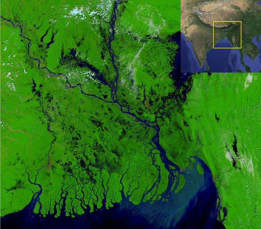
their region.

      •   Delta-DAT: Consolidate data on bio-physical, social, and economic parameters into an
          international repository of integrated data sets and make these readily available relevant
          data for use by the community at large to assess critical parameters, compute vulnerability
          metrics, and provide input data to the Deltas-RADS modeling framework.

      •   Delta-GDVI: Develop Global Delta Vulnerability Indices that capture the current and
          projected physical-social-economic status of deltas around the world (“delta vulnerability
          profiles”). The GDVI will be presented in a spatially explicit, GIS, format at high spatial
          resolution. It can be used to identify and support the critical needs and priorities for
          research, funding, and action

      •   Delta-ACT: Work with regional teams and stakeholders to put the products of Delta-SRES,
          Delta-RADS and Delta-DAT into action by demonstrating the implementation of the
          developed framework to three major deltas. The selected deltas are the Ganges-
          Brahmaputra-Meghna (GBM), Mekong, and Amazon deltas. These deltas were selected as
          they are each globally significant and encompass a range of physical and social
          environments. In addition, the DELTAS team has extensive experience in these systems and
          will leverage numerous ongoing research projects and regional contacts to form a
          foundation for adapting our framework to other deltas around the world.

  Key components of the DELTAS project, whereby deltas are treated as fully coupled socio-ecological systems
  and scientist-stakeholder feedback is emphasized at all levels.

Using the above framework, the DELTAS project will investigate several key questions in delta
functioning and vulnerability, towards proposing sustainable solutions. These questions include:

      (1) How do climate change, pressure on resources, and engineering/ infrastructure development
          make delta people, biodiversity, and ecosystems vulnerable?
      (2) How is this vulnerability to be measured?
      (3) How do delta areas absorb extreme events? What are the hydrological and ecological
          thresholds underlying the integrity of a delta region?

                                                       4
(4) What are the relevant local and regional biophysical and social stressors for a particular
        delta system, how do these interact, and how do they vary spatially and over time?
    (5) How can regional delta sustainability be balanced with economic growth? and
    (6) How can one reduce future risk while attaining sustainable development?

 Project Team:

 The BF-DELTAS project harnesses the collaboration of several, international and diverse teams of
 specialists with expertise in physical and social sciences, economics, health and demographics.
 These teams include government and university researchers, and NGO’s, with close relationships to
 policy makers and managers who are responsible for implementing the actions that will ensure
 delta sustainability. The BF-DELTAS teams include:

USA: E. Foufoula-Georgiou (University of Minnesota – Lead Institution); I. Overeem (University of
Colorado at Boulder); S. Goodbred Jr. and C. Wilson (Vanderbilt University); C. Vorosmarty and Z.
Tessler (City College of New York); E. Brondizio (Indiana University)

Japan: Y. Saito (National Institute of Advanced Industrial Science and Technology, acting through
Geological Survey of Japan)

Germany: C. Kuenzer (University of Wuerzburg); F. Renaud and Z. Sebesvari (United Nations
University, Institute for Environment and Human Security, Bonn, Germany)

France: E. Anthony (Centre National de la Recherche Scientifique, CNRS)

United Kingdom: R. Nicholls, Z. Matthews, J. Dearing, A. Lazar, A. Baschieri and S. Szabo
(University of Southampton); N. Burgess, M. Sassen and A. van Soesbergen (World Conservation
Monitoring Centre)

India: R. Ramesh (National Centre for Sustainable Coastal Management, Ministry of Environment,
Forests and Climate Change); T. Ghosh (Jadavpur University)

Netherlands: M. Marchand and T. Bucx (Stichting Deltares)

Bangladesh: K.M. Ahmed (University of Dhaka); Md.M. Rahman (Bangladesh University of
Engineering and Technology)

Vietnam: V. L. Nguyen (Vietnam Academy of Science and Technology); M. Goichot (World Wide
Fund for Nature-Vietnam Program Office)

Brazil: S. Costa (University of Vale do Paraíba)

Canada: G. Lintern (Natural Resources Canada); P. Van Cappellen and H. Durr (University of
Waterloo)

China: S.Gao (Nanjing University)

Norway: A. Newton (Norwegian Institute for Air Research)

                                                   5
6
2. Timeline and Project Organization

                                       7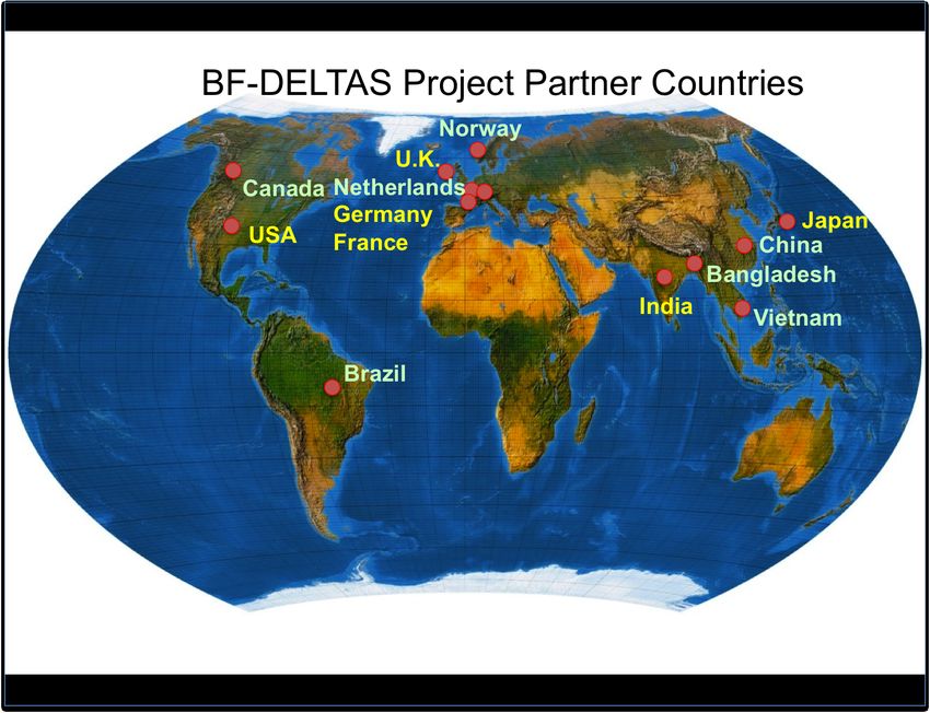
3. Projects reported and Integration under the 5 Work Packages (WP)

The Principal Investigator (PI) contributions attached are on:
1. A new Algorithm for Improved Satellite Rainfall Retrieval over Snow-Covered Land Surfaces and
Coastal Zones (Foufoula–Georgiou)
2. Delta channel network topology and dynamics for delta comparison, physical inference and
vulnerability assessment (Foufoula–Georgiou)
3. GIS delta data for model simulations (Overeem)
4. Ganges-Brahmaputra delta study using the new service components (Overeem)
5. Data Acquisition and Processing (Brondizio)
6. Deltas-DAT support for manuscript preparation and data visualization (Brondizio)
7. Utilization of the iRODS server and iDROP interface (Brondizio)
8. Automatic processing of high-resolution optical remote sensing data (Kuenzer)
9. Land cover classification for the Ganges-Brahmaputra river delta (Kuenzer)
10. Environmental Stress and Vulnerability analysis (Vorosmarty and Tessler)
11. Environmental Stress Typology (Vorosmarty and Tessler)
12. Precipitation and surface inundation patterns (Vorosmarty and Tessler)
13. Development of a theoretical framework (Renaud and Sebesvari)
14. Review of vulnerability indicators used in the three model deltas (Renaud and Sebesvari)
15. Identification of indicators by stakeholders in all three model deltas (Renaud and Sebesvari)
16. Bedload extraction within the G-B River delta—co-location with topography and the backwater
(Goodbred Jr.)
17. Natural and Human-Induced Changes in G-B Tidal Channel Network (Goodbred Jr.)
18. Fluvial-Tidal Land surface and hydrodynamics at Natural vs Poldered Areas (Goodbred Jr.)
19. Shoreline changes in the Mekong delta (Anthony)
20. Suspended particulate matter dynamics at the mouth of the Amzon and downdrift mangrove
changes on the Amazon-Orinoco coast (Anthony)
21. Shoreline changes in the Ganges-Brahmaputra delta (Anthony)
22. Collation and correction of SRTM topographic data and adjustment to local cartographic and
topographic datasets in deltas (Ramesh)
23. Collection of census data for economic, social, and demographic variables and association to
geospatial data platforms for deltas (Ramesh)
24. Assimilation of data on flooding and sediment aggradation; habitat modification; climate change
effects; demographics and socio-economics (Ramesh)
25. Map ecosystem dynamics (derivation from satellite imagery - mangrove decline, coastline
changes, and urban sprawl) (Ramesh)
26. The bio-physical, ecological, geomorphology, and climate data from the Gangetic delta region
collected and compiled in a IT-enabled GIS modelling platform (Ramesh)
27. Data acquisition and data collection of socio-economic and demographic indicators in Mekong,
GBD and Amazon (Matthews and Szabo)

                                                   8
WP1: Delta-SRES (Lead PIs: Efi Foufoula-Georgiou, John Dearing)
   •   A new Algorithm for Improved Satellite Rainfall Retrieval over Snow-Covered Land
       Surfaces and Coastal Zones (Foufoula–Georgiou)
   •   Delta channel network topology and dynamics for delta comparison, physical inference and
       vulnerability assessment (Foufoula–Georgiou)

WP2: Delta-RADS (Lead PIs: Irina Overeem, Zoe Matthews)
   •   GIS delta data for model simulations (Overeem)
   •   Ganges-Brahmaputra delta study using the new service components (Overeem)
   •   Data acquisition and data collection of socio-economic and demographic indicators in
       Mekong, GBD and Amazon (Matthews and Szabo)

WP3: Delta-DAT (Lead PIs: Eduardo Brondizio, Charles Vorosmarty, Yoshiki Saito)
   •   Data Acquisition and Processing (Brondizio)
   •   Deltas-DAT support for manuscript preparation and data visualization (Brondizio)
   •   Utilization of the iRODS server and iDROP interface (Brondizio)
   •   Automatic processing of high-resolution optical remote sensing data (Kuenzer)

WP4: Delta-GDVI (Lead PIs: Fabrice Renaud, Zita Sebesvari)
   •   Environmental Stress and Vulnerability analysis (Vorosmarty and Tessler)
   •   Environmental Stress Typology (Vorosmarty and Tessler)
   •   Precipitation and surface inundation patterns (Vorosmarty and Tessler)
   •   Development of a theoretical framework (Renaud and Sebesvari)
   •   Review of vulnerability indicators used in the three model deltas (Renaud and Sebesvari)
   •   Identification of indicators by stakeholders in all three model deltas (Renaud and Sebesvari)

WP5: DELTA-ACT (Lead PIs: Ian Harrison, Marc Goichot)
Delta-ACT Ganges: Steven Goodbred Jr.
   •   Bedload extraction within the G-B River delta—co-location with topography and the
       backwater (Goodbred Jr.)
   •   Natural and Human-Induced Changes in G-B Tidal Channel Network (Goodbred Jr.)
   •   Fluvial-Tidal Land surface and hydrodynamics at Natural vs Poldered Areas (Goodbred Jr.)
   •   Ganges-Brahmaputra delta study using the new service components (Overeem)
   •   Shoreline changes in the Ganges-Brahmaputra delta (Anthony)
   •   Land cover classification for the Ganges-Brahmaputra river delta (Kuenzer)
   •   Collation and correction of SRTM topographic data and adjustment to local cartographic and
       topographic datasets in deltas (Ramesh)
   •   Collection of census data for economic, social, and demographic variables and association to
       geospatial data platforms for deltas (Ramesh)
   •   Assimilation of data on flooding and sediment aggradation; habitat modification; climate
       change effects; demographics and socio-economics (Ramesh)
   •   Map ecosystem dynamics (derivation from satellite imagery - mangrove decline, coastline
       changes, and urban sprawl) (Ramesh)
   •   The bio-physical, ecological, geomorphology, and climate data from the Gangetic delta
       region collected and compiled in a IT-enabled GIS modelling platform (Ramesh)
   •   Data acquisition and data collection of socio-economic and demographic indicators in
       Mekong, GBD and Amazon (Matthews and Szabo)

                                                 9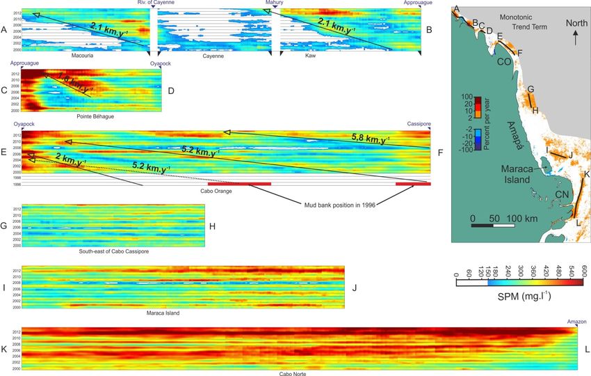
Delta-ACT Mekong: Claudia Kuenzer
   •   Automatic processing of high-resolution optical remote sensing data (Kuenzer)
   •   Shoreline changes in the Mekong delta (Anthony)
   •   Data acquisition and data collection of socio-economic and demographic indicators in
       Mekong, GBD and Amazon (Matthews and Szabo)

Delta-ACT Amazon: Eduardo Brondizio
   •   Definition of Amazon Delta/Estuary study site (Brondizio)
   •   Suspended particulate matter dynamics at the mouth of the Amazon and downdrift mangrove
       changes on the Amazon-Orinoco coast (Anthony)
   •   Data acquisition and data collection of socio-economic and demographic indicators in
       Mekong, GBD and Amazon (Matthews and Szabo)

                                               10
4. Principal Investigator Reports
Integrated Work Package 1: Sustainability science of deltas as coupled socio-ecological systems
(Delta-SRES)
Delta environments are complex systems integrating multiple nested spatial and temporal scales, and
are subject to multiple drivers of change. While links between environment, ecosystem services, and
human well-being are widely asserted [Cinner et al., 2009; Vo et al., 2012], these relationships are
poorly understood in deltaic environments, despite the fact that they would form the basis of any
sustainability initiative for these important systems. Hence the objective of this Integrated Work
Package is to advance sustainability science for deltas (Delta-SRES) by developing the required,
theoretical framework for assessing delta vulnerability and the possibility for transitions to undesired
biophysical or socio-economic states under various scenarios of change. The work for Delta-SRES
has been led by the University of Minnesota (UMN). Their research efforts have concentrated on two
main areas: (1) a new algorithm for improved satellite rainfall retrieval over coastal zones and (2)
transport and vulnerability in river deltas: a graph-theoretic approach. Application of the developed
frameworks will be performed in the Mekong, Ganges, and Amazon river deltas, which are the focal
study sites for the DELTAS project (see Integrated Work Package 5: Delta-ACT). However, the
developed frameworks are general and transferable to other deltas.
Integrated Work Package 2: Development of Delta Risk Assessment and Decision Support
Framework (Delta-RADS).
Modeling is the essential tool for understanding complex systems such as deltas. Hence the objective
of this Integrated Work Package is to co-develop, in close collaboration between scientists and
stakeholders, an open-access, science-based, integrative modeling framework. The first phase of
developing this framework has been to build on the infrastructure of the Community Surface
Dynamics Modeling System (CSDMS) lead by the University of Colorado at Boulder (UCB). The
UCB team has integrated studies of remote-sensing data with in-situ data and numerical modeling to
define sedimentation patterns and subsidence in deltaic lowlands (Yellow River, China, Indus Delta,
Pakistan, and Ganges Brahmaputra Delta, Bangladesh). The developed models are being integrated
into an open-source, freely available web-based modeling framework being developed by CSDMS.
Application of the developed modeling framework will be performed in the Mekong, Ganges, and
Amazon River deltas, which are the focal sites for the DELTAS project (see Integrated Work Package
5); however, the developed frameworks are general and transferable to other deltas.
Integrated Work Package 3: Delta International Data Repository (Delta-DAT).
Although relevant datasets for regional delta studies are available in many forms, they are widely
dispersed and thus provide limited utility for researchers and end-users. Hence the objective of this
Integrated Work Package is to consolidate and make readily available relevant data on bio-physical,
social, and economic parameters (Delta-DAT), which can be used by the community at large to assess
critical parameters, compute vulnerability metrics, and provide input data to the Deltas-RADS
modeling framework. The Indiana University (IU) team developed an initial data needs assessment.
They created a Delta-DAT prototype database spreadsheet to assist with data needs assessment and
acquisition of bio-physical and socio-economic datasets that will be important for Delta-DAT, and
useful for the DELTAS research teams at large. This spreadsheet was shared with the group for
review and comments/input. Based on the recommendations of the needs assessment, the IU team
have developed and concluded a Delta-DAT module for the Amazon delta area, including the
collection and integration of comprehensive multi-temporal biophysical and social data in a
Geographic Information Systems (GIS) (see Integrated Work Package 5).
11The German Aerospace Center and the University of Wurzburg have been seeking out existing data
sources that provide information for the three project’s focus regions (see Integrated Work Package
5), for integration into Delta-DAT. Eleven datasets have been compiled so far. To assure that these
datasets are readily accessible they are provided in a common data format such as Tiff or shape file.
These datasets also contribute to the tasks in the Delta-ACT work package.
The team at CUNY Environmental CrossRoads Initiative has designed and implemented a plan for a
shared, and potentially distributed, data storage and distribution system that meets the objectives of
Delta-DAT.
Integrated Work Package 4: Development of Global Delta Vulnerability Indices (Delta-GDVI)
Globally, several risk, resilience and/or vulnerability indices have already been developed with
different spatial resolutions. However, no comprehensive “vulnerability profile” metrics currently
exist that are spatially explicit at high spatial resolutions for deltas, even though profound spatial
variability exists in all delta systems critically affecting the ability for successful local decision-
making. Thus, the objective of this Integrated Work Package is to develop an integrated set of indices
that capture the current and projected physical-social-economic status of deltas around the world
(“delta vulnerability profiles”), which will serve to identify and support the critical needs and
priorities for research, funding, and action. In the second year of the Belmont Forum funded project,
the United Nations University and City University of New York have collaborated in leading the
development of the GDVI.
Integrated Work Package 5: Regional Implementation Case Studies (Delta-ACT)
The Delta-ACT component of the project seeks to apply the framework of Delta-SRES, Delta-RADS,
Delta-DAT, and Delta-GDVI to three diverse, globally significant delta systems in which the research
team has extensive experience and connections with the local community. The case study sites are:
the Ganges-Brahmaputra-Meghna (GBM), Mekong, and Amazon deltas.
I. The Ganges-Brahmaputra-Meghna (GBM) Delta
The GBM Delta is one of the world’s largest (~100,000 km2) and most dynamic deltas draining land
from Bangladesh, Bhutan, China, India and Nepal. The delta covers most of Bangladesh and part of
West Bengal, India, with many of the 147 million people (in 2000) living in the delta under extreme
poverty and facing multiple challenges. The population is expected to increase by 28% by 2015
[Overeem and Syvitski, 2009]. Already 30% of Bangladesh is within 5 m of sea level, experiencing
tidal water movement 100 km inland during the dry season [Allison, 1998]; and relative sea-level rise
that exceeds global-mean sea-level rise, demonstrating subsidence. Together these factors make the
GBM delta one of the most vulnerable coastal regions in the 21st century [Nicholls and Goodbred,
2005].
Ensemble CCSM experiments predict 11% higher rainfall during the Asian monsoon [Meehl and
Washington, 1993; May, 2004; IPCC, 2007], which would result in a larger sediment supply to the
GBM delta in the future. In contrast, the proposed construction of numerous mega dams and major
diversions upstream in India and China threaten sediment starvation to the sinking delta plain [Syvitski
et al., 2009], as well as reduced water availability in the dry season, which is already a serious
problem. Reduced river flows and intensive shrimp farming cause severe saltwater intrusion in the
coastal fringe degrading the ecosystem, and ultimately making the land uninhabitable.
12II. The Mekong Delta
The Mekong Delta is considered as the world’s third largest delta (with an area of 93,781 km2 and
population of 17 million), is one of Asia’s main food baskets, and is second only to the Amazon in
terms of fish biodiversity [WWF, 2008]. The major challenges in the MRD can be attributed to socio-
economic transformation and urbanisation processes leading to the degradation of the last natural
forest and wetland areas, accompanied by increasing water pollution [Kuenzer and Renaud, 2012].
The MRD is now undergoing large-scale erosion, especially in the muddy mangrove-rich western part
[Vo et al., 2012], increasing its vulnerability under projected sea-level rise and impacting future food
security [Gebhardt et al., 2012; Leinenkugel et al., 2011; Kuenzer and Knauer, 2013]. Other activities
include large-scale sand mining in the river and delta reaches, mangrove removal for shrimp farms,
dikes and embankments to protect shrimp farms from flooding, and future large-scale hydropower
development upstream [Kuenzer et al., 2012]. The fact that the Mekong river catchment is shared
among six countries (China, Myanmar, Lao PDR, Thailand, Cambodia and Vietnam) is a potential
source of conflict in harnessing the resources of the basin, especially hydropower development
[Grumbine and Xu, 2012; Grumbine et al., 2012]. Hydropower needs are expected to rise 7% a year
over the next 20 years and plans afoot will, if implemented, exhaust the river’s hydropower-
generating capacity [Mekong River Commission, 2010], leading to a seven-fold increase in the
reservoir sediment trapping efficiency [Kummu et al., 2010] with adverse effects on fisheries [Ziv et
al., 2012] and coastal erosion [Le et al., 2007; Wang et al., 2011; Xue et al., 2011; Räsänen et al.,
2012].
13III. The Amazon Delta
The Amazon River is the world’s largest, contributing 20% (175,000 m3/s) of the total global river
discharge to the oceans and discharging the highest total sediment load [Martinez et al., 2009;
Wittmann et al., 2011]. The delta includes vast estuarine wetlands at the mouth of the river and
sustains equally vast muddy wetlands >1500 km north along the coast, influencing the coastal
economies of Brazil, French Guiana, Surinam, Guyana and Venezuela [Anthony et al., 2010; Anthony
et al., in press]. However, like the GBMD and MRD, the conversion of mangrove forests to shrimp
farms in the ARD and north along the coast are an emerging environmental challenge [Anthony and
Gratiot, 2012a; 2012b; Rovai et al., 2012].
In terms of other environmental challenges that are typically associated with delta systems, the ARD
is often classified as ‘low risk’ because of its limited damming and water/oil extraction (e.g., Syvitski
et al., 2009). However, deforestion proceeds at a rapid pace, and population, economy, and
infrastructure in Amazonia are growing quickly. Furthermore, the projected construction of dams,
ports and aqueducts as part of the ongoing regional integration development policies is expected to
impact water and sediment flow from large tributaries such as the Madeira and Xingu rivers to the
ARD [GeoAmazonia, 2009]. The Amazonian basin is also currently under a massive plan for
infrastructure transformation including continental cross-national highways, river and sea-ports, and a
sequence of dams combining transportation river-ways and hydro-electrical plants. Ultimately, like all
deltas, the ARD faces multiple, imminent environmental threats.
1415
Efi Foufoula–Georgiou’s group

                                      University of Minnesota

  Anthony Longjas, Alejandro Tejedor, Jonathan Czuba, Mohammad Danesh-Yazdi,
                 Amy Hansen, Jon Schwenk, and Zeinab Takbiri

Research Themes and Accomplishments during 2014-2015
Our research efforts over the past year have concentrated on two main areas: (1) a new algorithm for
improved satellite rainfall retrieval over snow-covered land surfaces and coastal zones and (2) delta
channel network topology and dynamics for delta comparison, physical inference and vulnerability
assessment. Application of the developed frameworks will be performed in the Mekong, Ganges, and
Amazon river deltas, which are the focus of the DELTAS project funded under NSF Belmont Forum-
G8 Collaborative Research. However, the developed frameworks are general and transferable to other
deltas.

1. A new Algorithm for Improved Satellite Rainfall Retrieval over Snow-Covered Land
Surfaces and Coastal Zones.

Accurate estimation of rainfall over coastal regions will improve our ability to understand the socio-
ecological response of these vulnerable systems to extremes, improve flood forecasting and risk
management practices. In these regions, ground measurements from rain gauges and ground radars
are not readily available and satellites offer the only reliable source of data. The launch of the
Tropical Rainfall Measuring Mission (TRMM) satellite set a benchmark for spaceborne estimation of
rainfall over the tropics, providing an invaluable set of decadal rainfall observations with
unprecedented accuracy and coverage. The recently launched Global Precipitation Measurement
(GPM) core satellite, together with a constellation of partner satellites, will provide a considerably
extended spatial coverage of precipitation over higher latitudes. However, improvements on the
accuracy and space-time resolution of precipitation retrievals over complex land surfaces require the
development of new methodologies.

For precipitation retrievals over land, using satellite measurements in microwave bands, it is
important to properly discriminate the weak rainfall signals from strong and highly variable
background surface emission. Traditionally, land rainfall retrieval methods often rely on a weak signal
of rainfall scattering on high-frequency channels (85 GHz) and make use of empirical thresholding
and regression-based techniques. Due to the increased ground surface signal interference,
precipitation retrieval over radiometrically complex land surfaces—especially over snow-covered
lands, deserts and coastal areas—is of particular challenge for this class of retrieval techniques.

To address this, we evaluated the results by the recently proposed Shrunken locally linear embedding
Algorithm for Retrieval of Precipitation (ShARP), over a radiometrically complex terrain and coastal
areas using the data provided by the TRMM satellite [Ebtehaj et al., 2015]. We explore the idea of
“implicitly” encoding the land surface information content across all available frequency channels. In
essence, the a priori database in this Bayesian algorithm is properly organized in an algebraically
tractable manner via two fat matrices, called “rainfall” and “spectral dictionaries”. Spectral dictionary
contains a large a priori collection of brightness temperature (BT) measurements, while the rainfall
dictionary encompasses their corresponding simulated or observed rainfall profiles. Given a pixel-

                                                   16
level measurement of spectral BT values, this algorithm relies on a nearest neighbor search that uses
information content of all frequency channels to properly narrow down the retrieval problem to a few
physically relevant spectral candidates and their rainfall profiles. In this step, our algorithm classifies
the measured BT values into raining and non-raining signatures via a simple probabilistic voting rule
(detection step). Then for the raining BT measurements, it exploits a modern regularized weighted
least-squares estimator to retrieve the rainfall values of interest (estimation step).
To this end, the ShARP retrieval experiments are performed over a region in South and Southeast
Asia, partly covering the Tibetan Highlands, Himalayas, Ganges-Brahmaputra-Meghna river basins
and its delta. This region is unique in terms of its diverse land surface radiation regime and
precipitation type within the TRMM field of view.
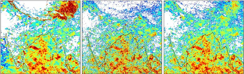
Figure 1. The three month rainfall [mm] retrievals--October-December of 2013--over the southwest Asia
including the Tibetan Highlands and Ganges-Brahmaputra-Meghna river basin, shown at 0.1-degree. The
standard TMI-2A12 (left panel), radar PR-2A25 (right panel) and ShARP retrievals. The results clearly indicate
that ShARP can significantly mitigate the effects of background noise due to snow cover lands, which results in
rainfall over estimation over the Himalayan range and headwaters of the Brahmaputra river basin. These results
promise improved hydrologic analysis of mid-latitude and in cold climates.
We elucidate promising results by ShARP over snow covered land surfaces and at the vicinity of
coastlines, in comparison with the land rainfall retrievals of the standard TRMM-2A12 product.
Specifically, using the TRMM-2A25 radar product as a reference, we provide evidence that the
ShARP algorithm can significantly reduce the rainfall over estimation due to the background snow
contamination and markedly improve detection and retrieval of rainfall at the vicinity of coastlines
(see Figure 1). During the calendar year 2013, we demonstrate that over the study domain the root
mean squared difference can be reduced up to 38% annually, while the reduction can reach up to 70%
during the cold months.
2. Delta channel network topology and dynamics for delta comparison, physical
inference and vulnerability assessment.
River deltas are intricate landscapes with complex channel networks that self-organize to deliver
water, sediment, and nutrients from the apex to the delta top and eventually to the coastal zone. The
natural balance of material and energy fluxes, which maintains a stable hydrologic, geomorphologic,
and ecological state of a river delta, is often disrupted by external perturbations causing topological
and dynamical changes in the delta structure and function. A formal quantitative framework for
studying delta channel network connectivity and transport dynamics and their response to change is
lacking.
We have introduced a graph theoretic approach for studying delta channel networks, where deltaic
systems are represented by rooted directed acyclic graphs. Using spectral graph theory we developed
methods for extracting sub-networks from apex to the shoreline, upstream and downstream
subnetworks, and for computing steady flux propagation in the network. The latter allowed us to
17construct vulnerability maps that quantify the relative change of sediment and water delivery to the
shoreline outlets in response to possible perturbations in hundreds of upstream links [Tejedor et al.,
2015a]. We also developed metrics that capture unique physical, topological, and dynamical aspects
of delta networks with the ultimate objective that deltas projected in such a “metric space” can be
compared and contrasted and also analyzed for relative vulnerability (or resilience) to change. The
framework was applied to seven major deltas and its potential for delta classification and comparison
was demonstrated [Tejedor et al., 2015b].
A river delta, characterized by its channel network, is represented by a directed graph, i.e., a
collection of vertices (bifurcations and junctions in the delta) and directed edges (channels in-between
vertices, where the direction is given by the flow). All information about the network connectivity can
be stored in a sparse adjacency matrix that allows us to extract important network topologic
information by straightforward algebraic manipulations (Figure 1).
Figure 1. Quantitative framework for studying delta channel network connectivity based on spectral graph
theory.
We used this framework to introduce a suite of graph-theoretic and entropy-based metrics, to quantify
two components of a delta’s complexity: (1) Topologic, imposed by the network connectivity and (2)
Dynamic, dictated by the flux partitioning and distribution. The metrics are aimed to facilitate
comparing, contrasting, and establishing connections between deltaic structure, process, and form.
We illustrate the proposed analysis using seven deltas in diverse morphodynamic environments and of
various degrees of channel complexity (see Figure 2 left panel). We project deltas into a topo-
dynamic space whose coordinates are given by the topologic and dynamic delta complexity metrics,
and show that this space provides a basis for delta comparison and physical insight into their dynamic
behavior (Figure 2 right panel). Jointly, the topologic and dynamic complexity of a rive delta places it
in a unique position in the delta topo-dynamic space, revealing that as topologic complexity decreases
(e.g., fewer loops and simpler subnetwork structures connecting the apex to the shoreline outlets) the
dynamic complexity (flux exchanged among subnetworks) increases. At the limit of minimum
(maximum) topologic (dynamic) complexity is a purely bifurcating tree and we see that the simpler
and younger deltas (e.g., Wax Lake and Mossy) are, in fact, closer to such a bifurcating tree in the
topo-dynamic space. This is also observed in all other metrics.
18Figure 2. (left) Location of seven deltas and their corresponding channel networks numbered according to size
(largest to smallest area). We used the Smart and Moruzzi [1971] networks for (1) Niger, (2) Parana, (3) Yukon,
(4) Irrawaddy, and (5) Colville Deltas. For (6) Wax Lake we used the network extracted by Edmonds et al.
[2011]. We have extracted the network of (7) Mossy from Google Earth. Satellite images are copyrighted by
Digital Globe Inc. 2014. (right) Topo-dynamic complexity space for deltas. The x-axis corresponds to the
dynamic exchange of the different subnetworks measured by the Leakage Index (LI), and the y-axis corresponds
to the topologic complexity measured by the Number of alternative paths from apex to outlet (Nap). Each colored
cross corresponds to a different delta, and the orange dot corresponds to a binary tree. The vertical (horizontal)
component of each cross runs from the 25th until the 75th percentile of the Number of alternative paths (Leakage
Index).
We also show that the examined metrics relate to the intuitive notion of vulnerability, measured by the
impact of upstream flux changes to the shoreline flux (Figure 3). The topologic and dynamic
complexity of deltas seem to relate to its vulnerability to change, i.e., to the way a delta responds in
propagating upstream disturbances to its shoreline outlets. Specifically, we report an inverse non-
trivial relationship between vulnerability and two indices of topologic (Number of alternative paths)
and dynamic (Conditional Entropy) metrics.
Figure 3. Relation of Vulnerability to Topologic and Dynamic Complexity. Vulnerability Index vs. Number of
alternative paths (left) and vs. Dynamic Conditional Entropy (right). As expected, the more complex a delta is
the more “robust” it is to change. This is because alternative paths and equitable flux distribution minimize the
effects of a flux change in upstream links to the flux reaching the outlet.
Finally, a spatially-explicit interrogation of a delta in terms of its normalized number of links versus
normalized distance from the apex (delta width function) reveals that one can quantify easily deltas
that are mostly divergent, convergent or geologically confined, as well as transitions from one regime
to another (Figure 4a).
19Figure 4. Spatially explicit metrics of complexity. (Right panels) Schematic representation of contours radially
scaled at normalized distances of 25%, 50%, 75% and 100% of the current shoreline. The squares show the
intersections at the different distances. (a) Delta width function for the seven deltas examined. (b) Each line
represents the smoothened trajectory in the topo-dynamic complexity space (intersection of the mean of both
Leakage Index and Number of alternative paths) for each radially scaled delta from the apex to the shoreline.
Note, that if actual data on shoreline and channel network evolution existed this plot would capture the
progression of the topo-dynamic complexity of the evolving delta.
We observe that for tree-like deltas (Wax Lake and Mossy), the normalized number of links is an
increasing function of the normalized distance achieving the maximum at the current shoreline similar
to the behavior for the binary tree. More complex deltas, on the other hand, attain a maximum before
the current shoreline (e.g., Irrawaddy at normalized distance ≈ 0.78, Colville and Niger ≈ 0.90, and
Yukon ≈ 0.95) except for Parana with maximum located at the current shoreline. These results
highlight the idea that Parana can be thought of as two deltas in tandem [Smart and Moruzzi, 1971]:
the upper half near the apex with a narrow region similar to braided rivers containing the core links,
and the lower half with a topology similar to a bifurcation-dominated delta. Although the spatial
analysis of a mature delta cannot be used as a surrogate for its temporal evolution (due to the
possibility of internal rearrangement of channels caused by avulsions and major flooding) it can still
be used as a rough proxy. Figure 4b shows the evolution of the seven deltas in the topo-dynamic
space. The arrows indicate the direction of increasing distance from the apex. Each line corresponds
to the mean topologic complexity and to the mean dynamic complexity as we move from the apex to
the shoreline. From a spatial evolution perspective, deltas evolve by increasing their topologic
complexity (in terms of Nap) and decreasing their dynamic complexity (in terms of LI). This is
compatible with the idea that young (old) deltas are topologically simple (complex) with subnetworks
exchanging a large (small) proportion of fluxes.
Future Research (2015–2016)
In the next year our focus will be along the following lines:
1. A new Algorithm for Improved Satellite Rainfall Retrieval over Snow-Covered Land
Surfaces and Coastal Zones
201. We will identify all the TRMM overpasses over Ganges, Mekong, and Amazon for a five-
year period (initially and longer periods later) and obtain the TMI (passive sensor) and PR
(active sensor) data from NASA’s TRMM web site.
2. We will apply the developed methodology of rainfall retrieval, using TRMM passive
microwave and coincidental PR radar, over the Ganges, Mekong, and Amazon deltas for
several extreme storms and compare these retrievals to the current NASA products (2A-12).
3. We will collaborate with the team of Prof. Steve Goodbred at Vanderbilt University (partner
of the BF-DELTAS project) to obtain rain gauge data in the Ganges for validation of the
retrieval algorithm.
4. We will collaborate with the team at CUNY and the German Remote Sensing Data Center
(partners of the Belmont Forum project) to develop delta inundation maps and incorporate
this information into precipitation retrievals.
2. Delta channel network topology and dynamics for delta comparison, physical
inference and vulnerability assessment.
1. We will acquire SRTM topography data and extract the channel network for the Amazon
River Delta. For Year 2, we have extracted manually the channel network for the Mekong
Delta and did some preliminary analysis.
2. We will populate the topo-dynamic space with more deltas and advance the idea of using
these metrics for delta classification.
3. We will analyze delta channel network evolution using historical data to quantify how delta
complexity changes over time, e.g., according to the processes involved such as avulsions
versus channel growth. The first case study will be the Wax Lake delta for which channel
networks of the delta are available and the delta is simple enough to extract the networks
manually. Extension to other deltas will be performed in Year 3.
4. We will quantify how channel network complexity might change as a function of the scale at
which the channels are resolved. What can be learned from such a multi-scale analysis of
complexity?
5. We will analyze simulated deltas using Delft 3D or RCMs under varying sets of physical
parameters and compare the topo-dynamic space of simulated deltas to the space of real deltas
(the seven deltas already analyzed and some new ones) to gain insight into process and form.
6. We will extend the analysis to “networks upon networks” (beyond channels) to model surface
to sub-surface flux exchange, nutrient transport, and ecological processes on deltas using
graph theoretic approaches.
References
Ebtehaj, A., R. Bras, and E. Foufoula-Georgiou (2015), Shrunken Locally Linear Embedding for
Passive Mi- crowave Retrieval of Precipitation, IEEE Trans. Geosci. Remote., 53(7), 3720–3736,
doi:10.1109/TGRS.2014. 2382436.
Edmonds, D. A., C. Paola, D. C. J. D. Hoyal, and B. A. Sheets (2011), Quantitative metrics that
describe river deltas and their channel networks, J. Geophys. Res., 116, F04022,
doi:10.1029/2010JF001955.
Smart, J. S. and V. L. Moruzzi (1972), Quantitative properties of delta channel networks, Z.
Geomorphol., 16, 283-309.
Tejedor, A., A. Longjas, I. Zaliapin and E. Foufoula-Georgiou (2015a), “Delta channel networks: 1. A
graph-theoretic approach for studying connectivity and steady-state transport on deltaic surfaces”,
Water Resources Research, doi: 10.1002/2014WR016577.
21Tejedor, A., A. Longjas, I. Zaliapin and E. Foufoula-Georgiou (2015b), “Delta channel networks: 2.
Metrics of topologic and dynamic complexity for delta comparison, physical inference and
vulnerability assessment, Water Resources Research, doi: 10.1002/2014WR016604.
Group Publications 2014-2015 (partially funded by this grant)
Czuba, J.A. and E. Foufoula-Georgiou (2014), A network-based framework for identifying potential
synchronizations and amplifications of sediment delivery in river basins, Water Resour. Res., 50,
doi:10.1002/2013WR014227.
Czuba, J.A., and E. Foufoula-Georgiou (2015), Dynamic connectivity in a fluvial network for
identifying hotspots of geomorphic change, Water Resour. Res., 51(3), 1401-1421,
doi:10.1002/2014WR016139.
Ebtehaj, A.M., M. Zupanski, G. Lerman, and E. Foufoula-Georgiou (2014), Variational data
assimilation via sparse regularisation, Tellus A, 66, 21789, doi: 10.3402/tellusa.v66.21789.
Ebtehaj, A.M., R.L. Bras, and E. Foufoula-Georgiou (2015), Shrunken locally linear embedding for
passive microwave retrieval of precipitation, IEEE Trans. on Geosci. and Remote Sens., 53(7), 3720-
3736, doi:10.1109/TGRS.2014.2382436.
Ebtehaj, A.M., E. Foufoula-Georgiou, G. Lerman, and R.L. Bras (2015), Compressive Earth
Observatory: An insight from AIRS/AMSU retrievals, Geophys. Res. Lett., 42(2), 362-369,
doi:10.1002/2014GL062711.
Foufoula-Georgiou, E., A.M. Ebtehaj, S.Q. Zhang, and A.Y. Hou (2014), Downscaling satellite
precipitation with emphasis on extremes: A variational ℓ1-norm regularization in the derivative
domain, Surveys in Geophysics, 35(3), 765-783, doi:10.1007/s10712-013-9264-9.
Gangodagamage, C., E. Foufoula-Georgiou, and P. Belmont (2014), River basin organization around
the mainstem: scale invariance in tributary branching and the incremental area function, J. Geophys.
Res. Earth Surf., 119(10), 2174-2193, doi: 10.1002/2014JF003304.
Guala, M., A. Singh, N. B. Bull, and E. Foufoula-Georgiou (2014), Spectral description of migrating
bedforms and sediment transport, J. Geophys. Res. Earth Surf., 119, doi:10.1002/2013JF002759.
Keylock, C., A. Singh, J.G. Venditti, and E. Foufoula-Georgiou (2014), Robust classification for the
joint velocity-intermittency structure of turbulent flow over fixed and mobile bedforms, Earth Surf.
Process. Landforms, 39(15), 1717-1728, doi: 10.1002/esp.3550.
Keylock, C.J., A. Singh, and E. Foufoula-Georgiou (2014), The complexity of gravel bed river
topography examined with gradual wavelet reconstruction, J. Geophys. Res. Earth Surf., 119(3), 682-
700, doi:10.1002/2013JF002999.
Kuenzer, C., I. Klein, T. Ullmann, E. Foufoula-Georgiou, R. Baumhauer, and S. Dech (2015),
Remote Sensing of River Delta Inundation: exploiting the Potential of coarse spatial Resolution,
temporally-dense MODIS Time Series, Remote Sensing.
Hansen, A.T., J.A. Czuba, J. Schwenk, A. Longjas, M. Danesh-Yazdi, D. Hornbach, and E. Foufoula-
Georgiou (2015), Coupling freshwater mussel ecology and river dynamics using a simplified dynamic
interaction model, Freshwater Science, in revision.
Niannian F., D. Zhong, B. Wu, E. Foufoula-Georgiou, and M. Guala (2014), A mechanistic-stochastic
formulation of bed load particle motions: From individual particle forces to the Fokker-Planck
22equation under low transport rates, J. Geophys. Res. Earth Surf., 119(3), 464-482,
doi:10.1002/2013JF002823.
Ning, L., F. P. Carli, A. M. Ebtehaj, E. Foufoula-Georgiou, and T. T. Georgiou (2014), Coping with
model error in variational data assimilation using optimal mass transport, Water Resour. Res., 50,
5817–5830, doi:10.1002/ 2013WR014966.
Pelletier, J.D., A.B. Murray, J.L. Pierce, P.R. Bierman, D.D. Breshears, B.T. Crosby, M. Ellis, E.
Foufoula-Georgiou, A.M. Heimsath, C. Houser, N. Lancaster, M. Marani, D.J. Merritts, L.J. Moore,
J.L. Pederson, M.J. Poulos, T.M. Rittenour, J.C. Rowland, P. Ruggiero, D.J. Ward, A.D. Wickert, and
E.M. Yager (2015), Forecasting the response of Earth's surface to future climatic and land-use
changes: A review of methods and research needs, Earth's Future, 3, doi:10.1002/2014EF000290.
Schwenk, J., S. Lanzoni, and E. Foufoula-Georgiou (2015), The life of a meander bend: connecting
shape and dynamics via analysis of a numerical model, J. Geophys. Res. Earth Surf., 120(4), 690-710,
doi:10.1002/2014JF003252.
Singh, A., L. Reinhardt, and E. Foufoula-Georgiou (2015), Landscape re-organization under changing
climatic forcing: results from an experimental landscape, Water Resour. Res.,
doi:10.1002/2015WR017161.
Singh, A., P. R. Wilcock and E. Foufoula-Georgiou (in preparation), Effect of evolving bed
topography on tracer dynamics, J. Geophys. Res. Earth Surf.
Tejedor, A., A. Longjas, I. Zaliapin and E. Foufoula-Georgiou (2015a), “Delta channel networks: 1. A
graph-theoretic approach for studying connectivity and steady-state transport on deltaic surfaces”,
Water Resour. Res., doi: 10.1002/2014WR016577.
Tejedor, A., A. Longjas, I. Zaliapin and E. Foufoula-Georgiou (2015b), “Delta channel networks: 2.
Metrics of topologic and dynamic complexity for delta comparison, physical inference and
vulnerability assessment, Water Resour. Res., doi: 10.1002/2014WR016604.
Conference presentations and abstracts:
Czuba, J.A., and E. Foufoula-Georgiou (2014), Assessing river basin resilience to natural and human
disturbances, Institute on the Environment Sustainability Symposium, St. Paul, Minnesota, 11 April.
Czuba, J.A. and E. Foufoula-Georgiou (2014), Network Dynamic Connectivity for Identifying
Hotspots of Fluvial Geomorphic Change, AGU Fall Meeting, San Francisco, California, 15-19
December.
Danesh-Yazdi, M., A. Tejedor, and E. Foufoula-Georgiou (2014), Self-dissimilar Landscapes:
Probing into Causes and Consequences via Multi-scale Analysis and Synthesis, AGU Fall Meeting,
San Francisco, California, 15-19 December.
Ebtehaj, M., E. Foufoula-Georgiou, and R. Bras (2014), A New Framework for Robust Retrieval and
Fusion of Active/Passive Multi-Sensor Precipitation, AGU Fall Meeting, San Francisco, California,
15-19 December.
Foufoula-Georgiou, E., J. Czuba, and I. Zaliapin (2014), Dynamic connectivity and response to
change in a river network: what can be learned for managing river basins?, EGU2014-14510, HS1.1,
EGU General Assembly, Vienna, Austria, 27 April – 2 May [INVITED].
23Foufoula-Georgiou, E. and M. Ebtehaj (2014), From Rainfall Downscaling to Rainfall Retrieval:
Inverse Problems of Similar Nature, EGU General Assembly, Vienna, Austria, 27 April – 2 May
[INVITED].
Foufoula-Georgiou, E. (2014), Belmont Forum Deltas Project (BF-DELTAS) – to sustain the
resilience of deltas, Deltas in Times of Climate Change II International Conference, Rotterdam,
Netherlands, 24-26 September.
Foufoula-Georgiou, E., A. M. Ebtehaj and Z. Tessler (2014), Satellite Rainfall Retrieval Over Coastal
Zones, Deltas in Times of Climate Change II International Conference, Rotterdam, Netherlands, 24-
26 September.
Foufoula-Georgiou, E., A. Tejedor, A. Longjas, I. Overeem, F. Renaud and J. Dearing (2014),
Constructing vulnerability maps of material and energy pathways in deltas, Deltas in Times of
Climate Change II International Conference, Rotterdam, Netherlands, 24-26 September.
Foufoula-Georgiou, E. (2014), Mathematical Hydrology and Vulnerability Science: the come-back of
a systems approach for Sustainability, AGU Fall Meeting, San Francisco, California, 15-19 December
[INVITED].
Foufoula-Georgiou, E., A. Tejedor, A. Longjas, and I. Zaliapin (2014), “Quantitative Metrics of
Robustness in River Deltas”, AGU Fall meeting, San Francisco, California, 15-19 December.
Foufoula-Georgiou, E., A. M. Ebtehaj, and R. Bras (2015), A Novel Bayesian algorithm for
Microwave Retrieval of Precipitation from Space: Applications in Snow and Coastal Hydrology,
EGU2015-7585, EGU General Assembly, Vienna, Austria, 12-17 April [SOLICITED].
Foufoula-Georgiou, E., J. Schwenk, and A. Tejedor (2015), Perspective – Open problems in earth
surface dynamics require innovative new methodologies from graph theory and non-linear analysis,
EGU2015-8805, EGU General Assembly, Vienna, Austria, 12-17 April.
Gangodagamage, C., E. Foufoula-Georgiou, P. Belmont, B. Mackey, and T. Fuller (2014), Statistical
Signature of Deep-seated Landslides, AGU Fall Meeting, San Francisco, California, 15-19 December.
Harrison, I.J., E. Foufoula-Georgiou, and B. Burkholder (2014), Catalyzing action towards
sustainability of deltaic systems in collaboration with colleagues in the Belmont Forum DELTAS
project. IUCN World Congress on Protected Areas. Stream 4: Supporting Human Life. November 18,
2014.
Longjas, A., A. Tejedor, I. Zaliapin, S. Ambroj, and E. Foufoula-Georgiou (2014), Network
Robustness: the whole story, AGU Fall Meeting, San Francisco, California, 15-19 December.
Longjas, A., V. Voller, N. Filipovitch, K. Hill, C. Paola, and E. Foufoula-Georgiou (2014), “What
might rice piles tell us about non-local sediment transport?”, AGU Meeting, San Francisco,
California, 15-19 December.
Longjas, A., A. Tejedor, I. Zaliapin, and E. Foufoula-Georgiou (2015), “Vulnerability maps of deltas:
quantifying how network connectivity modulates upstream change to the shoreline”, CSDMS Annual
Meeting, Boulder, Colorado, 26-29 May.
Schwenk, J., E. Foufoula-Georgiou, and S. Lanzoni (2014), Revisiting nonlinearity in meandering
river planform dynamics using Gradual Wavelet Reconstruction, AGU Fall Meeting, San Francisco,
California, 15-19 December.
24Singh, A., A. Tejedor, I. Zaliapin, L. Reinhardt, and E. Foufoula-Georgiou (2014), Emergent
reorganization of an evolving experimental landscape under changing climatic forcing, AGU Fall
Meeting, San Francisco, California, 15-19 December.
Singh, A., A. Tejedor, I. Zaliapin, L. Reinhardt, and E. Foufoula-Georgiou (2015), Experimental
evidence of dynamic re-organization of evolving landscapes under changing climatic forcing,
EGU2015-8726, EGU General Assembly, Vienna, Austria, 12-17 April.
Takbiri, Z., J.A. Czuba, and E. Foufoula-Georgiou (2014), Complex hydrologic changes in frequency-
magnitude response due to shifting agricultural practices in the Midwestern US, AGU Fall Meeting,
San Francisco, California, 15-19 December.
Tejedor, A., A. Longjas, I. Zaliapin, and E. Foufoula-Georgiou (2014), Defining network robustness
using a dual connectivity perspective, 30th IUGG Mathematical Geophysics, Merida, Mexico, 2-6
June.
Tejedor, A., A. Longjas, I. Zaliapin, and E. Foufoula-Georgiou (2014), Network topology, Transport
dynamics, and Vulnerability Analysis in River Deltas: A Graph-Theoretic Approach, AGU Fall
Meeting, San Francisco, California, 15-19 December.
Tejedor, A., A. Longjas, I. Zaliapin, and E. Foufoula-Georgiou (2015), “A graph-theoretic approach
to River Deltas: Studying complexity, universality, and vulnerability to change”, EGU General
Assembly, Vienna, Austria, 12-17 April.
Tejedor, A., A. Longjas, I. Zaliapin, and E. Foufoula-Georgiou (2015), “A graph-theoretic approach
to Studying Deltaic Systems: Quantifying Complexity and Self-Organization”, CSDMS Annual
Meeting, Boulder, Colorado, 26-29 May.
Tejedor, A., A. Longjas, I. Zaliapin, J. Syvitski, and E. Foufoula-Georgiou (2015), “Complexity and
Robustness of Deltaic systems: A graph-theoretic approach”, INQUA, Japan.
Tessler, Z., C. Vörösmarty, E. Foufoula-Georgiou, and M. Ebtehaj (2014), Spatial and temporal
patterns of rainfall and inundation in the Amazon, Ganges, and Mekong deltas, Deltas in Times of
Climate Change II International Conference, Rotterdam, Netherlands, 24-26 September.
Zanardo, S., A. Hilberts, E. Foufoula-Georgiou, and W. Dietrich (2014), Emergent phase shift
between diurnal transpiration maxima and stream flow minima during base flow as diagnostic of eco-
hydrologic interactions in landscapes, EGU General Assembly, Vienna, Austria, 27 April – 2 May.
25Irina Overeem and Stephanie Higgins
Community Surface Dynamics Modeling System
Research Themes and Accomplishments during 2014-2015
The objective of Integrated Work Package 2 is to develop an open-access, science-based, integrative
modeling framework called the Delta Risk Assessment and Decision Support (RADS) Tool. We have
begun construction of this tool on top of the CSDMS open-source modeling framework, developed
under separate NSF funding. CSDMS’s Web-based Modeling Tool, called WMT, provides a graphical
interface and a server-side database that allows users to build and run coupled surface dynamics
models on a high-performance computing cluster [Syvitski et al., 2014] (Fig. 1). Under Belmont
Forum funding in Year 2, we have developed service components for Delta-RADS that facilitate delta
risk modeling. These service components, described below, will shortly be incorporated into WMT
and released as Delta-RADS after testing.
Figure 1. The Web Modeling Tool at csdms.colorado.edu, which allows users to submit modeling tasks to the
supercomputer Beach and download output through the web.
1. GIS delta data for model simulations
Delta-RADS aims to include a GIS modeling system to support quantitative mapping and definition of
functional relationships of the bio-physical environment of deltas as well as their social and economic
dynamics. Towards that end, we have developed tools to generate GeoTIFFs and shapefiles of relevant
datasets for delta modeling, which users can download to use in other studies or convert into model
input file formats for simulations in Delta-RADS. Fig. 2 shows an example of drainage basins in
Southeast Asia defined with a new service component. Using this tool, the user specifies the latitude
and longitude of a point of interest along a river (e.g., the brown and black circles in Fig. 2, which
correspond to gauging stations on the Ganges and Brahmaputra rivers, respectively). New Python
wrappers automatically execute routines from the open-source Terrain Analysis Using Digital
Elevation Models (TauDEM) program (David Tarboton, Utah State University). The drainage basin
river network is delineated and watershed boundaries are established. Resulting shapefiles and raster
datasets can be downloaded and opened with any GIS program, including ArcMAP or the open-source
GRASS or QGIS. These watershed boundaries then can be overlayed with global map datasets e.g.
population density or GDP and these data can then be clipped appropriately. The next tool generates
26You can also read