Boating and water sports - Tasman District Council
←
→
Page content transcription
If your browser does not render page correctly, please read the page content below
FREE!

                       Boating and
                       water sports
                            in Tasman District 2019/2020

5 knots within 200m of
shore (unless uplifted).

           5 knots                                5 knots
             only                                   only

                200m line

                            200m line

    For more information visit:
    tasman.govt.nz/recreation/boating-fishing
    or scan this QR code with your smartphone >
Puponga
Whanganui
Inlet TASMAN COAST
Pakawau BOAT RAMP ACCESS
Not for navigation
The Tasman coast is subject to New Zealand’s largest tidal range.
Check for hazards including logs and sandbanks before heading out
GOLDEN BAY on the water. Many channels and bars should only be attempted with
COLLINGWOOD
local knowledge or on a rising tide on a calm day. Coastal boat ramps
Parapara
Aorere or beach launching areas exist at the areas shown on this map.
There are also ramps at:
Onekaka Separation Point
Lake Rotoiti (Kerr and West Bays)
Patons Rock Wainui Bay Lake Rotoroa
Tata Bay Buller River at Murchison
Totaranui
Rangihaeata
Note: Take care to avoid scouring holes
Milnthorpe
Parapara Waitapu
Pohara
Awaroa Bay
when using unsealed launching areas,
Tarakohe Ligar Bay
as this creates a hazard for other users.
TAKAKA
Please fill any holes you create and
Tonga Island notify the Harbourmaster if a hazard
Parapara Inlet exists. Use your winch rather than
Bark Bay powering onto your trailer.
*Please note the Mapua boat ramp has restricted access.
Torrent Bay
Stilwell Bay
Apple Tree Bay
Marahau
Honeymoon Bay
Upper Takaka
Breaker Bay
Otuwhero Kaiteriteri
Inlet
Kaiteriteri
Stephens Bay
Torlesse Rock
Riwaka
MOTUEKA
Anawera Point
Stephens Bay
Jackett Island Mapua*
Kina
Ngatimoti Tasman
Unformed, No fee TASMAN BAY Grossi Point
Bird Island
LEGEND:
Hard concourse, Fee applies Ruby Bay Bronte
Orinoco
Waimea Inlet
Unformed, no fee Hard concourse, no fee
Hard concourse, No fee Rough Island
Hard concourse, fee applies Aquaculture Management Area Rabbit Island
Mahana
Aquaculture Management Area
Waimea Inlet
Best Island
RICHMOND
CONTENTS WELCOME
Tasman District is a boating paradise, but a day out on the water can turn to disaster
General Information: Tide tables and news: if you are unprepared and don’t play by the rules. All boaties should know the
National Navigation Safety Rules (www.maritimenz.govt.nz/recreational/the-basics/
18 Summer news
5 Basic rules of the sea skipper-responsibilities) and their local Navigation Safety Bylaw Rules. Tasman
19 Summer news District’s Navigation Safety Bylaw controls all inland waterways and coastal waters
6 Before you go!
20 Tide tables up to 12 miles offshore within Tasman District.
6 Essential equipment
22 Tide tables
7 Safe boating When you ski, sail, motor, jetski, row or paddle any boat in the Tasman District, you
8 Swimming / Fishing are subject to the rules in the bylaw. This brochure explains some of these rules
from the current Navigation Safety bylaw. Please ensure you are up to date with the
9 Night-time navigation
Other information: rules before heading out on the water. A full copy of the current bylaw along with
9 Commercial vessel operations other useful navigation safety information, may be viewed on the Tasman District
23 Marine farms
9 Instant fines Council website tasman.govt.nz. Copies of the bylaw can also be seen at Tasman
23 Marine forecasts District Council service centres or libraries.
9 Launch wardens
24 Useful contacts
10 Marine VHF radio
24 Tasman boating clubs HARBOURMASTER CONTACT
44 If things go wrong…
25 Special events If you have any questions about boating in the Tasman District, please contact the
Harbourmaster by calling any Tasman District Council office
(see back cover) or email harbourmaster@tasman.govt.nz
Use of jet boats and Location specific maps BASIC RULES OF THE SEA
other craft on rivers: and information:
• Always keep a good lookout and travel at a safe speed.
11 Rules and regulations 26 Collingwood
• Powerboats give way to sailing, rowed or paddled vessels (e.g. kayaks).
27 Port Tarakohe
• In general, alter course to starboard (right) to avoid other vessels and keep a 50
28 Tata Beach metre buffer zone.
Waterskiing, Towing
29 Totaranui • When on converging courses, the vessel looking at the port (left side and red
Biscuits & PWC (Jetski):
30 Torrent Bay light) of the other vessel gives way. Best action is to alter course to starboard and
12 Location map of ski and pass behind the right of way (stand on) vessel. Stop if necessary.
31 The Anchorage
PWC areas and access lanes • All skippers should know Maritime Rule Part 22 – Collision Prevention (see
32 Stilwell Bay
13 Personal water craft (PWC) www.maritimenz.govt.nz), like all drivers should know the road code. Carry a
32 Marahau
13 Waterskiing horn and the correct lights for your vessel.
33 Adele Island
13 Places you may not waterski
14 Your obligations
34 Kaiteriteri
BOAT SAFELY – KNOW THE RULES
35 Stephens Bay
14 Your rights Vessels overtaking: Every overtaking boat 1 Lifejackets – take them,
36 Port Motueka gives way (includes sailing vessels). wear them
Endorsed by the National Pleasure Boat Safety Forum
15 Ski access lanes and 2 Skipper responsibility – keep
37 Kina Peninsula
GIVEWAY
reserved areas everyone safe. Know your vessel
and your limits
38 Mapua Power vessels head on: Both alter to
16 Marine reserves starboard (right). 3 Emergency communications –
38 Hunter Brown carry two types that work when wet
GIVEWAY GIVEWAY
(VHF, EPIRB, flare, cell phone)
39 Rabbit Island Power vessels crossing: Power boats give 4 Marine weather – check first.
If in doubt don’t go out
40 Traverse way to others on their starboard side.
5 Avoid alcohol
WAY
GIVE
41 Traverse Maximum speed:
• Within 200m of shore or dive flag.
42 Lake Rotoiti • Give way boats should cross behind. • Within 50m of all boats or
• Sailing vessels have different rules. swimmers.
BE A RESPONSIBLE SKIPPER
DO A DAY SKIPPER COURSE
4 5
BEFORE YOU GO                                                                             SAFE BOATING
There are many navigation hazards (rocks, reefs etc) along the Abel Tasman                1. Speed and wake
coastline and some of these are unmarked. Boaties are advised to check their
navigation charts and do thorough planning before heading out on the water.               Your speed must not exceed 5 knots:
                                                                                          •    within 200 metres of the shore, any structure, or a
                                                                                               diver’s blue and white flag
Know the boating safety code
                                                                                          •    within 50 metres of any other vessel or any person
                                                                                               in the water (unless allowed by an access lane or
                 Check Coastal Forecast at www.metservice.co.nz before                         reserved area)
                 you go, and Nowcast on VHF channel 79 at sea. Conditions
                                                                                          •    if anyone is bow-riding or is leaning over the side
                 can change very quickly, it is important to listen in to
                 updated maritime forecasts while out on the water.                       In general, if your vessel is producing a minimal wake you will be
                                                                                          travelling at under 5 knots.
                 Keep your cellphone in a sealed bag in a zipped pocket.                  People in the water are at most risk from speeding boats, skiers and jetskiers.
                 Dial 111 or VHF radio channel 16 in an emergency, flares,
                                                                                          Remember, when there is no speed limit skippers must ensure their boat’s wake
                 and a registered 406MHz EPIRB are recommended.
                                                                                          does not create a risk and that they travel at a speed which is safe for the conditions.
                                                                                          Note that 3 knot limits apply at the Anchorage, Torrent Bay and beside Adele Island,
                 Alcohol affects judgement and reaction times. It also                    and also adjacent to the marina at Port Motueka. In these areas you should trim
                 changes how your body reacts when unexpectedly                           and adjust speed for no appreciable wake. Even if beyond the 200 metre distance
                 plunged into the water.
                                                                                          from shore, you must be aware of the size of wake your vessel is generating when
                                                                                          underway and alter speed and trim accordingly so that your wake doesn’t cause a
                 Lifejackets must be worn when being towed, crossing                      danger or nuisance to others. No one under the age of 15 may operate a motorised
                 a bar or in adverse conditions such as rough seas. They                  craft capable of exceeding 10 knots unless under direct supervision.
                 should be worn in vessels prone to capsize, and when
                 travelling at high speed, especially while on rivers or
                 riding on personal watercraft (jetskis). We recommend                    2. Pollution and supplies
                 wearing them at all times.                                               All vessels are required to comply with the marine pollution regulations. These
                                                                                          prohibit the discharge of untreated sewage (particulate waste) within 500 metres
                                                                                          of shore or a marine farm, 200 metres of a marine reserve, or in water less than
                                                                                          5 metres deep. This effectively prohibits discharge of untreated sewage within
ESSENTIAL EQUIPMENT                                                                       Astrolabe Roadstead, or in the greater Torrent Bay, for example. Urine is acceptable.
Lifejackets (aka Personal Flotation Devices or PFDs) – one of the correct size is
required for everyone on board and must be within reach, (it is important to ensure       It is also illegal to discharge plastics or oils into the water. All oil spills must by law be
that CO2 cartridge type jackets are regularly serviced).                                  reported immediately to the Council’s Regional On-Scene Commander on
Bailing system – as well as electric bilge pumps, always have a bucket available for      Ph. 03 543 8400 or to Maritime New Zealand.
bailing or to use as a sea anchor.
                                                                                          Please retain all rubbish aboard for proper disposal ashore. Details of fuel and water
An anchor – 1 1/2 kg per metre of boat length, plus chain at least equal to the boat
length and at least 30 metres of warp (rope).                                             supplies are at tasman.govt.nz/transport/ports-and-wharves/fuel-and-water.

Alternative power – spare outboard and fuel, or oars in case of engine failure.
                                                                                          3. Diving
Fire extinguisher – one of the greatest risks at sea is from fire. Fuel fires cannot be
extinguished with water.                                                                  Divers and snorkellers are vulnerable to propellers and
Compass and charts – know where you are, where safe refuge is and where the               speeding boats. Keep well clear of likely diving locations
dangers lie. A new Tasman Bay chart (NZ614) was published in September 2015,              like rocky headlands or anchored boats when travelling at
and a new Abel Tasman chart (NZ6144) was published in 2009.                               speed. If you see a divers’ flag, reduce speed to dead slow
Communication – marine VHF radios are recommended but cellphones are                      within 200m, and keep a sharp watch for bubbles or people in the water. When
useful for parts of our coastline. EPIRBs must be of the new 406MHz type, and             diving from a boat, both the skipper and the divers are responsible for ensuring
should be registered with RCCNZ for efficient rescue. If VHF is fitted, you should        any approaching boat can clearly see your dive flag from at least 200m away. The
maintain a watch on Ch16 and hold an operator’s certificate to transmit unless in         flag must be over 600mm along its shortest edge. The boatman should wave it if
an emergency.                                                                             needed, and keep the boat between the divers and any approaching boat where
Distress flares – an orange smoke for daytime use and a handheld red flare for            possible, an air horn is also a good idea to alert boaties that don’t appear to have
night time use are recommended as minimum. Know how to use them in the dark!              seen your dive flag. Shore-based divers are also strongly advised to tow (or anchor)
First aid kit – be able to treat minor injuries.                                          a dive flag on a float when diving, for your own protection.
Other useful gear – spare rope, torch, boat hook, sharp knife.

6                                                                                                                                                                                     7
4. Paddling                                                                                 NIGHT-TIME NAVIGATION
The Maritime Rules and Navigation Safety Bylaws apply to all small craft, including
kayaks and paddleboards. Paddlers are encouraged to travel close to shore. Within           All vessels (including paddlecraft) must show the correct lights from sunset to
200 metres of shore other vessels should also be travelling slowly (except in water         sunrise and during restricted visibility, when underway or at anchor.
ski areas or access lanes), and you get a closer look at the scenery.                       Ensure that you meet the minimum standards for a boat of your size and type.
                                                                                            See www.maritimenz.govt.nz for more details. Note that vessels over 7 metres long
Small paddle craft can be hard to see and usually do not show on a boat’s radar.
                                                                                            must also show a black ball if anchored during the day. A black buoy hung from the
Kayaks and other similar small craft are encouraged to follow Maritime NZ
                                                                                            forward rail is ideal for most recreational boats.
guidelines. Display a brightly coloured flag and ensure that paddle blades are
brightly coloured to aid visibility. For the same reason, kayaks should be finished in a    Details of many of the lights at marine farms and other aids to navigation around
colour that contrasts with the marine environment. Wearing a brightly coloured hat          the Tasman coast can be found at tasman.govt.nz, or scan the QR code on the
and a brightly coloured life jacket is also a good idea. When travelling as part of a       front cover. Please also refer to the appropriate nautical chart. Some marine farm
group, remain close together. This aids your visibility to other vessels and also allows    boundaries in the Tasman region are subject to seasonal change.
other vessels more room to pass.
When waterski lanes or areas are being used for waterskiing, other users, including
paddlecraft, may not enter the area. Please either wait until the ski area or lane is not
                                                                                            COMMERCIAL VESSEL OPERATIONS
occupied before proceeding quickly across it, or pass around the outside of the area        Any operator offering any sort of paddle craft or boat to the public for dedicated
at least 200 metres from shore.                                                             hire or as part of a package, or offering transport, requires a licence (or an
                                                                                            exemption in certain cases) from Tasman District Council. Authorised Commercial
Always carry two effective means of communication. Wear a lifejacket when on a
                                                                                            Vessel Operators are listed on the Tasman District Council website.
paddleboard, (when genuinely surfing, a leg rope maybe substituted for a lifejacket
to enable duck diving under waves).
Be aware that the favourable conditions usually enjoyed in this region over summer
                                                                                            INSTANT FINES
can rapidly change. Check the forecaset and do not paddle in rough or windy
                                                                                            Tasman District Council Navigation Safety Bylaws include infringement (instant fines)
conditions and ensure you have the right clothing to keep warm. Don’t kayak alone
                                                                                            provisions. Some of the instant fines that may be imposed are in the table below:
if you don’t have the skills or equipment to bail and re-enter after a capsize. Try the
online kayak safety module at www.cbes.org.nz.
                                                                                             OFFENCE DESCRIPTION                                                        FINE
SWIMMING                                                                                     Exceeding 5 knots within 200 metres of shore                               $200
There are two areas on Kaiteriteri Beach reserved for swimming and the like, and
one in the middle of the Kerr Bay beach at Lake Rotoiti during the summer months.            Failure to provide sufficient accessible lifejackets                       $100
There are no patrolled beaches, so swimmers should take extra care to consider
their safety before setting out.                                                             Not maintaining a ship in a seaworthy state                                $200
Think before you swim
                                                                                             Failing to carry an observer when towing                                   $100
• Can you be seen? Avoid areas with lots of boat traffic and consider a bright swim
  cap or fluoro t-shirt.
                                                                                             Creating a hazard to other vessels when anchored                           $100
• Avoid swimming near boat launching ramps or wharves when in use by boats.
  Especially watch out for children near ramps.
                                                                                             Towing a waterskier in breach of requirements                              $100
• Do not swim in areas reserved for waterskiing or access lanes if they
  are in use.
                                                                                             Not displaying a diver’s flag when necessary                               $100
• Avoid channels or other areas subject to strong currents, especially during
  outgoing tides. The Kaiteriteri lagoon outlet and Mapua channel are particularly
  hazardous and should be avoided during the middle two hours of outgoing tides.            LAUNCH WARDENS
• Know the water safety code, see www.adventuresmart.org.nz.
                                                                                            Honorary Launch Wardens will be checking on boating safety during the summer.
                                                                                            They are there to help and advise you about safety on the water. Although the
FISHING                                                                                     Tasman District Council Launch Wardens are there in an educative role, they do
                                                                                            have the powers to enforce provisions of Council Bylaws relating to water safety.
It is illegal to use fishing gear that creates an obstruction, danger or hazard to any
                                                                                            All wardens carry ID. If they ask for your name and address, you are legally obliged
person, vessel or property. Ensure marker buoys are clearly visible and labelled,
                                                                                            to supply information if you are in charge of a vessel. Launch wardens are unpaid
and do not set unattended fishing gear in any access lane or reserved area, or
                                                                                            volunteers. Please respect their advice as they have the safety of all water users at
navigation channel. If fishing near a wharf or narrow channel, please wind in your
                                                                                            heart, and a wealth of experience.
line to allow boats to pass safely. Be aware of the local Marine Reserve boundaries.
8                                                                                                                                                                                   9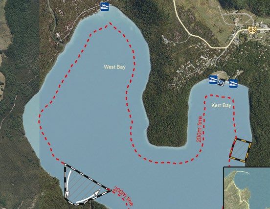
MARINE VHF RADIO                                                                  USE OF JET BOATS AND OTHER CRAFT
ALL DISTRESS AND EMERGENCIES CHANNEL 16                                           ON RIVERS
All VHF radio users must monitor Channel 16 and hold an operator’s certificate.
Contact Coastguard Boating Education at www.boatingeducation.org.nz.              A person in charge of a vessel on a river must:
for training or to register a callsign.                                           • Ensure that the vessel keeps to the starboard (right) side of the river channel.
                                                                                  • If going upstream, give way to any vessel coming downstream
LOCAL FREQUENCIES
                                                                                  • Not operate the vessel unless river and weather conditions permit safe operation
•    Marlborough-Nelson Marine Radio VHF Channels 04 and 60 (users of               of the vessel.
     Marlborough-Nelson Marine Radio should subscribe to this service,
                                                                                  • Avoid causing a nuisance or danger with your wake. Take special care during the
     Contact marineradio@xtra.co.nz)                                                whitebaiting season, and near eroding river banks.
•    Farewell Maritime Radio VHF Channels 16 and 68
                                                                                  • Always travel at a safe speed. A good guide is a speed that allows you to turn
•    D’Urville Maritime Radio VHF channels 16 and 67                                about or stop completely in less than one third of the visible distance ahead.
•    Nelson Harbour Radio VHF channel 12                                          • Ensure a suitable buoyancy vest or lifejacket is worn by everyone aboard.
•    Coastguard VHF channel 4
                                                                                  • Slow to walking pace whenever within 50 metres of any other vessel or person in
After making contact, boats wishing to converse should change to                    the water. Watch for swimmers especially near settlements.
a working frequency. Channel 6 or 8 are suitable.
                                                                                  Locations and times where the speed limit (5 knots within
To contact a water taxi in the Abel Tasman area call:
                                                                                  200 metres of shore) on rivers is uplifted:
• Channel 7 – Abel Tasman Aqua Taxis and Marahau Water Taxis
                                                                                  • Aorere River: Between 15 August and 30 November, the speed limit is
• Channel 66 – Abel Tasman Sea Shuttles
                                                                                    uplifted only from Brown River confluence to Rockville bridge.
• Channel 3 – Wilsons Abel Tasman Experiences and Kahu Kayaks
                                                                                  • Aorere River: Between 1 December and 14 August, the speed limit is
Nelson Marine Forecasts can be heard on channel 79                                  uplifted only from Brown River confluence to the sea (tributaries are
                                                                                    excluded).
Remember, if you hear someone use the word “Mayday” on the radio
you must write down the message, and assist if you can. Relay the                 • Takaka River: the speed limit is uplifted only in the main branch between
message if no shore station seemed to hear it.                                      the powerhouse at the Cobb Reservoir at Drummond Flat and the sea, when
                                                                                    the flow at Kotinga exceeds 20 cumecs, (tributaries are excluded).
                                                                                  • Motueka River: the speed limit is uplifted only in the main branch between
                                                                                    the Tapawera Bridge and the State Highway Bridge at Motueka, when the
                                                                                    flow at Woodmans bend exceeds 50 cumecs (tributaries are excluded)
                                                                                  • Waimea and Wairoa Rivers: the speed limit is uplifted only from the
                                                                                    confluence of the Lee River to the sea when the flow at Wairoa at Irvines
                                                                                    exceeds 20 cumecs (see note),(tributaries are excluded).
                                                                                  • Buller River: the speed limit is uplifted for all waters (including tributaries)
                                                                                    downstream from the Mangles Confluence, to the boundary of the district.
                                                                                    Between 1 May and 30 September, the speed limit is uplifted for the waters
                                                                                    of the main branch (excluding tributaries) from the Harleys Rock Road Bridge
                                                                                    to the Mangles confluence when the flow at Longford exceeds 60 cumecs.
                                                                                  Note: Flow levels in these rivers can be determined by telephoning the
                                                                                  automatic river gauge reports Ph. 03 543 8555, or online at
                                                                                  tasman.govt.nz/environment/water/rivers/river-flow

10                                                                                                                                                                     11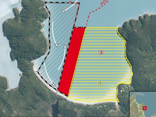
N WATERSKI ACCESS LANES PERSONAL WATERCRAFT (JETSKIS AND
AND RESERVED AREAS SIMILAR CRAFT)
Jetskis (PWCs) are fun, but can be dangerous if the model exceeds your skills. Learn
This map shows the location of
on a low power model before upgrading, and practise in the designated areas
waterski areas and waterski access
before heading offshore to play in the waves. Always take a flare and waterproofed
lanes along the Tasman District
communication (like a cellphone in a plastic bag).
coastline. There is also an access lane
Tata Beach at Lake Rotoiti.
Prohibited areas for PWCs (jetskis and similar craft)
A PWC play area is included in the
Totaranui
areas at Rabbit Island and Traverse. PWCs may not operate in the following areas:
PWCs may also tow a waterskier in any • Kaiteriteri Bay waterski area (even when towing a skier)
waterski access lane or reserved area • Kaiteriteri Bay unless operating at less than 5 knots
unless otherwise excluded, as long as
• Lake Rotoiti*
an observer is carried.
• Lake Rotoroa*
• Westhaven Inlet Wildlife Management Reserve*
• Otuwhero Inlet, unless speed is kept below 5 knots
• Don’t play in the surf zone at beaches unless there are no swimmers nearby and
you are over 200 metres from the shore.
Torrent Bay * Department of Conservation Bylaw or Regulations.
Browns Beach
(The Anchorage) Unless otherwise probibited you may use a PWC in a water skiing area as
long as you are towing a skier and have a rear-facing observer on board.
Stilwell Bay
Check your knowledge with the on-line PWC module at www.cbes.org.nz
Adele Island
(South side of sandpit)
WATERSKIING
‘Waterskiing’ means being towed, whether on waterskis, aquaplane,
surf board, biscuit, paraglider or any similar device, or barefoot.
Kaiteriteri KEY
Waterski access lane Places you may not waterski
• Anywhere within 200 metres of shore if there is no waterski access lane or area,
Area reserved for unless speed is below 5 knots (e.g. with a ski-biscuit).
waterskiing
• Within Kaiteriteri Bay
(including Little Kaiteriteri)
MOTUEKA Please note: except in the designated
waterski area and only 2
Torrent Bay, Kaiteriteri and
hrs either side of high tide.
Kina ski areas have special
PWCs (Jetskis) may not
restrictions. See location map
operate in Kaiteriteri Bay,
notes for details.
Kina
including when towing a
waterskier.
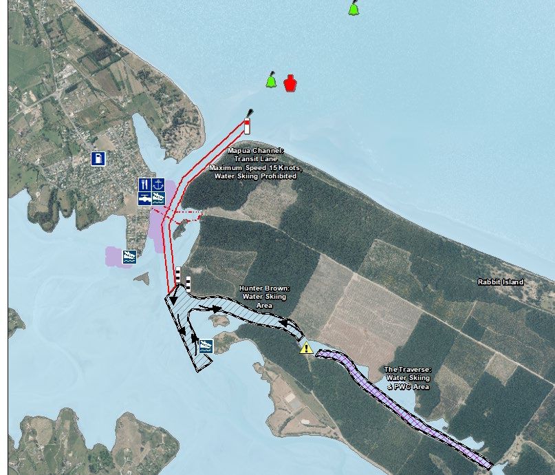
The Traverse and part of the
Rabbit Island area are shared • Otuwhero Inlet (Marahau).
areas for both waterskiers and • The “Go Slow” 3 knot speed
PWCs/Jetskis. limit areas around the
anchorage areas at The
Anchorage and beside
Adele Island.
• Lake Rotoroa.
Hunter Brown
5 0 5 10km Traverse
Rabbit Island
12 13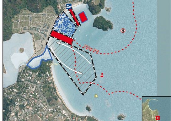
YOUR OBLIGATIONS                                                                        SKI ACCESS LANES AND
• You may only exceed 5 knots within 200 metres of the shore if you are within          RESERVED AREAS
  a waterski access lane, or an area reserved for waterskiing, whilst engaged in
  waterskiing. Skiing vessels still may not exceed 5 knots within:                      Ski access lanes and reserved areas have no special status unless actually in use
                                                                                        for skiing. At other times, normal rules apply. However, you should not leave boats
     – 50 metres of other vessels                                                       anchored or beached (unless pulled clear of the water) or set unattended fishing
     – 50 metres of swimmers                                                            gear in these areas at any time in case skiing begins.
     – or within 200 metres of a vessel showing a dive flag.
• Keep to the starboard (right) to avoid other vessels.                                 When skiing is taking place in a waterski area, or in or near a waterski lane, only
                                                                                        boats involved in skiing may enter or remain in the area or lane. Only boats towing a
• Don’t cause annoyance to others with the noise or wake that your boat makes.          skier may exceed the usual speed limits.
• Don’t ski or navigate in a manner that is dangerous to other users.
• Don’t obstruct other legitimate users of an access lane or skiing area. This          Users should:
  includes anchoring or beaching your boat inside the lane or area when not             • Stay as far as practicable to starboard (the right hand side), and circulate in an
  skiing.                                                                                 anti-clockwise direction only.
• No waterskiing between sunset and sunrise.                                            • Be aware of other boats and skiers, and watch for signals, dropped skis and fallen
• It takes three to ski! If towing anyone, your boat must have a driver and an            skiers.
  additional responsible person of at least 10 years of age acting as observer. Their   • Travel at a safe speed and distance from other users at all times.
  role is to relay signals between the skier and the driver and report any mishaps,     • Wait it out if sunstrike makes it difficult to see potential hazards.
  so the driver can concentrate on safe navigation.
• Please see page 19 for the new ‘ski tube restrictions’.                               Ski access lanes
• Carry a properly sized lifejacket (PFD) for each person aboard. They must be worn     Ski Access Lanes are marked with posts and, in most cases,
  in rough conditions, and all persons being towed must wear their PFD.                 buoys coloured orange with black bands.They are intended only
• Comply with instructions about the use of your boat given by the                      to provide access at speed for vessels towing a skier or similar
  Harbourmaster or Honorary Launch Wardens.                                             between the shore and the open water 200 metres off shore.
• The skier and observer should use standard hand signals, so that others around
                                                                                        Do not continue to ski within an access lane, nor use the marker buoys
  you can understand your intentions.
                                                                                        as a slalom course.

YOUR RIGHTS                                                                             Reserved areas
You are entitled to:                                                                    Reserved Areas are marked with posts and usually buoys,
• Make deep water starts and waterski at speed in any part of the coastal marine        coloured black with white bands. They may be for other
  area (see area maps for minor exceptions) provided the boat and skier are at least    specified purposes, including swimming. Check the adjacent
  200 metres off shore.                                                                 signage to ensure skiing is permitted. In an area reserved for
                                                                                        skiing you may continue skiing within the area after a beach start, unlike an access
• Use the waterski access lanes and waterski areas shown in this guide to waterski      lane. Stay within the area, do not use the marker buoys as a slalom course.
  off and onto beaches.
• Use waterski access lanes and areas along with other waterskiers. Note that the
  right to exclusive use only applies when the lane or area is actually in use. Other   Special marks
  craft may enter the access lane if it is not in use for waterskiing.                  Yellow buoys are used to mark special features, such as scientific
• Pull a waterskier with any sort of vessel (including a Personal Water Craft/jetski)   equipment, marine reserves or anchoring area boundaries.
  except in Kaiteriteri Bay or other prohibited areas.
                                                                                        Yellow spar buoys, often associated with round yellow floats, also
• Pull an inflatable toy such as a ski biscuit within 200 metres of shore as long as    indicate the nominal 5 knot limit line. In certain places (such as
  the 5 knot rule is observed until 200 metres offshore.                                Kaiteriteri) they are often closer than 200 metres to the nearest shore.
                                                                                        Everywhere else the 5 knot limit applies until 200 metres from the water’s edge, not
                                                                                        the high tide mark.

                                                                                        Note that it is illegal to interfere with or moor a vessel to any aid to navigation
                                                                                        without the owner’s written permission.

14                                                                                                                                                                            15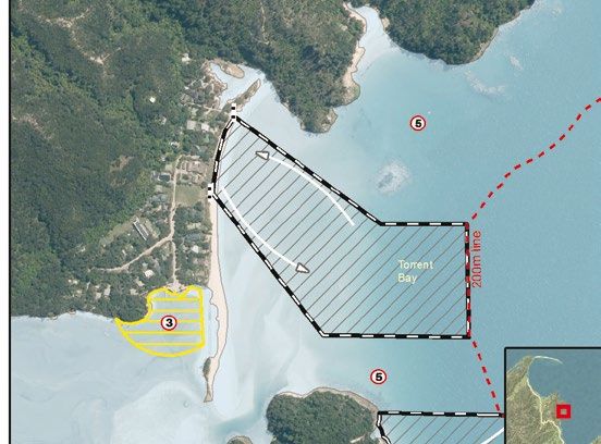
MARINE RESERVES
It is illegal to take any plant, animal or mineral from a marine reserve or to have
marine life or rigged fishing tackle aboard your boat.

For more information on marine reserves, see www.doc.govt.nz or visit a local
Department of Conservation (DOC) office.

Tonga Island Marine Reserve (Abel Tasman National Park)

Tonga Island Marine Reserve covers an area of 1835 hectares, extending one
nautical mile (1852 metres) offshore from the mean high water mark of Tonga
Island, and the coast between Awaroa Head and the headland separating Bark Bay
and Mosquito Bay.

Westhaven Te Tai Tapu Marine Reserve & Westhaven
(Whanganui Inlet) Wildlife Management Reserve (Golden Bay)

The marine reserve covers 536 hectares and includes all the tidal sandflats and
channels south of a straight line between Melbourne Point (Pah Point) and the
closest headland of Westhaven Scenic Reserve. It also includes all the tidal areas
upstream of causeways along Dry Road, southwest of and including the Wairoa
River. An area around the Mangarakau wharf is not included in either reserve.

16                                                                                    17
SUMMER 2019/2020 NEWS                                                                     Anchoring
                                                                                          During last summer several boats washed ashore when they dragged anchor, ensure
Navigation safety bylaw - Nelson lifejackets and registration
                                                                                          that you have the correct anchor type, Manson Supreme, Rocker and CQR type
All water users are reminded to check the Tasman 2015 Navigation Safety Bylaw to          anchors work well along the predominantly sandy Abel Tasman coastline, also ensure
remain up to date with the local rules that are likely to affect your boating, please     that you have adequate chain length, check your anchor warp for damage and
go to tasman.govt.nz and search “Navigation Bylaw”. Users of Nelson waters need to        always check the Marine Forecast, Northerly and Easterly winds (onshore) often cause
note that the Nelson Navigation Safety Bylaw has just been reviewed and takes effect      problems for boaties. Also remember that Tasman has one of the largest tidal ranges
from 1 October 2019. Some key provisions are: Lifejackets must be worn on vessels         in the country so allow extra anchor line to compensate. Beware nosing into beaches
less than 6 metres in length; Two forms of communication must be carried; Vessels
                                                                                          in trailer boats, it is usually safer to anchor off and reverse into the beach to avoid
must be registered or identified with owners name and address. Visit nelson.govt.nz/
                                                                                          swamping. Carrying a second sand anchor for a sternline is also advised
council/bylaws/bylaw-218-navigation-safety/.
                                                                                          Navigation
Local knowledge
                                                                                          Several boats also hit submerged rocks last summer, check your charts and
Tasman area rules and other regional boating information can be found at
                                                                                          understand what the Navigation markers mean (see pg 23 of this brochure).
tasman.govt.nz/recreation/boating-fishing. This includes details of local buoys and
                                                                                          Marine farms
beacons and specific advice for navigating into the regions ports and wharves.
Low tide aerial pictures of the channels leading into Mapua and Port Motueka are          Keep up to date with changes to Tasman and Golden Bay marine farm locations
recent additions to this website (Port Nelsons website is www.portnelson.co.nz). For      and extensions by checking on the Council’s web site; tasman.govt.nz/recreation/
details on how to access the local knowledge channel guide to Port Motueka, go to;        boating-fishing/marine-farms/ or tasman.govt.nz/council/media-centre/public-
tasman.govt.nz/transport/ports-and-wharves/ports-and-wharves-in-tasman/port-              notices/navigation-notices/ and also with LINZ Notices to Mariners www.linz.govt.
motueka/#navigation.                                                                      nz/sea/maritime-safety/notices-mariners
Safer Boating Campaign                                                                    Tides at secondary ports
Lifejackets and VHF radio are two of the main focuses of this years Safer Boating         For details go to LINZ website or the NZ Nautical Almanac. As a guideline, tides at
Campaign, “Check your Lifejacket” and “take marine VHF radio” more information can        Motueka, Kaiteriteri, Tarakohe and Collingwood occur at much the same time as
be found on; www.saferboating.org.nz/                                                     Nelson. Mapua high tides vary significantly depending on tide height, between
                                                                                          about 15 and 70 minutes after Nelson times. Tides in the Astrolabe Roadstead are
‘No excuses’ days
                                                                                          about 20 minutes before Nelson. Tides at the Westhaven Bar (Whanganui Inlet)
Maritime New Zealand and harbourmasters throughout New Zealand will again
                                                                                          occur 65 minutes before Westport. This remote bar should not be attempted
be re-running the No Excuses program where enforcement takes the place of
                                                                                          without recent local knowledge and a suitably equipped and experienced party of
education and for 5 random days over the summer season instant fines will be issued
                                                                                          vessels, in favourable weather.
for breaches of maritime laws. This year both near shore boat speed and lifejacket
carrying will be particularly targeted.                                                   Boats can sink very quickly, be prepared!
Ski tube restrictions                                                                     It is recommended that essential safety equipment is carried either on you, or in
                                                                                          an in accessible grab bag. Several local people have recently been saved from their
Fatalities and injuries have been caused as a result of boats towing multiple ski
                                                                                          sinking vessels by having a well-equipped and accessible floating grab bag!
biscuits. The Tasman Harbourmaster recommends that vessels are to tow only one
device and a maximum of 3 people.                                                         Carry at least 2 forms of communication:
Alert flags for towing vessels                                                            • Hand held VHF radio *: Channel 16          • Red hand held flares
Orange flags will be available from the harbourmaster for boats involved in towing. If    • Mobile phone *: Call 111                 • Distress beacon
somebody falls off a ski tube or water skis, the on-board observer is then to wave the      (*waterproof or in a sealed plastic bag)
flag to alert nearby boaties to look out for a person in the water.                       Aid to navigation changes
Navigation lights                                                                         Details of buoys and beacons, and specific advice for navigating near ports and
Boaties are reminded that it is a legal requirement to display Navigation lights during   wharves are available on the Tasman District Council website. Details for each area
the hours of darkness. This includes an all-round white light when anchoring.             above are at tasman.govt.nz/transport/ports-and-wharves/ports-and-wharves-in-
Inflatable swimming pool toys                                                             tasman. Please make sure your charts are up to date.
The harbourmaster has noticed an increasing trend for inflatable swimming pool toys       Events
to be used in the regions lakes, rivers and the sea. These toys are not robust enough     Many fun maritime events are run in the Tasman district each year, these range
to be used in this way and this practice is not recommended. Users are reminded that      from high speed power boating and waka races to fireworks displays, for details on
lifejackets must be worn if these inflatable swimming pool toys are to be used in the     these events visit tasman.govt.nz/recreation/boating-fishing/special-events-and-
regions waterways. Also be aware that these toys will be very quickly swept away in       activities/.
strong currents or an off shore breeze.                                                   PWC Training (Jetski) Course
Propeller safety                                                                          In an effort to provide a better education to PWC users in Tasman District Council
Near shore boating and swimming are conflicting activities and all boaties are            in conjunction with MaritimeNZ will be offering free PWC training. For more
reminded to keep a very through lookout for swimmers, be particularly vigilant            information visit tasman.govt.nz.
for persons in the water when boats are being launched or retrieved, and when
manoeuvring in tidal currents.
18                                                                                                                                                                            19
SUMMER 2019/2020 TIDE TABLES
November 2019 Nelson
January 2020 Nelson
Low Tides High Tides Low Tides High Tides
Date am m pm m am m pm m Date am m pm m am m pm m
1 Fri 7:04 0.6 7:14 0.8 12:59 4.1 1:19 4.2 1 Wed 8:20 1.0 8:38 1.2 2:26 3.6 2:35 3.7
2 Sat 7:46 0.9 7:57 1.1 1:43 3.8 1:59 3.9 2 Thu 9:01 1.2 9:26 1.3 3:08 3.4 3:20 3.6
3 Sun 8:30 1.1 8:49 1.3 2:30 3.6 2:43 3.7 3 Fri 9:49 1.4 10:19 1.4 3:54 3.3 4:11 3.4
4 Mon 9:21 1.3 9:58 1.5 3:22 3.3 3:34 3.4 4 Sat 10:48 1.5 11:16 1.4 4:46 3.2 5:09 3.3
5 Tue 10:23 1.5 11:23 1.6 4:24 3.2 4:41 3.2 5 Sun 11:58 1.6 5:47 3.1 6:11 3.3
6 Wed 11:40 1.6 5:34 3.1 6:02 3.2 6 Mon 12:15 1.4 1:08 1.5 6:57 3.2 7:11 3.4
7 Thu 12:35 1.5 12:56 1.5 6:47 3.1 7:15 3.3 7 Tue 1:16 1.4 2:07 1.4 8:04 3.3 8:06 3.5
8 Fri 1:31 1.4 1:57 1.4 7:51 3.3 8:10 3.5 8 Wed 2:14 1.3 2:57 1.2 9:01 3.5 8:58 3.6
9 Sat 2:16 1.2 2:45 1.2 8:44 3.5 8:53 3.7 9 Thu 3:09 1.1 3:42 0.9 9:49 3.7 9:47 3.8
10 Sun 2:56 1.0 3:25 1.0 9:27 3.7 9:31 3.9 10 Fri 3:59 0.9 4:25 0.7 10:32 4.0 10:35 3.9
11 Mon 3:33 0.9 4:00 0.8 10:05 3.8 10:07 4.0 11 Sat 4:46 0.7 5:08 0.6 11:14 4.2 11:23 4.0
12 Tue 4:08 0.8 4:33 0.7 10:41 4.0 10:41 4.1 12 Sun 5:31 0.6 5:51 0.5 11:55 4.3
13 Wed 4:42 0.7 5:06 0.6 11:15 4.1 11:17 4.1 13 Mon 6:14 0.5 6:36 0.5 12:10 4.1 12:36 4.4
14 Thu 5:17 0.6 5:39 0.6 11:49 4.1 11:53 4.1 14 Tue 6:57 0.5 7:23 0.5 12:57 4.2 1:19 4.3
15 Fri 5:54 0.6 6:15 0.7 12:23 4.1 15 Wed 7:41 0.6 8:13 0.6 1:44 4.1 2:05 4.2
16 Sat 6:33 0.7 6:54 0.8 12:32 4.0 12:59 4.1 16 Thu 8:27 0.7 9:05 0.8 2:32 4.0 2:54 4.1
17 Sun 7:14 0.8 7:40 0.9 1:15 3.9 1:38 4.0 17 Fri 9:17 0.9 10:02 0.9 3:21 3.9 3:48 3.9
18 Mon 8:00 0.9 8:34 1.1 2:03 3.7 2:23 3.8 18 Sat 10:17 1.1 11:03 1.1 4:15 3.7 4:49 3.7
19 Tue 8:52 1.1 9:41 1.2 2:57 3.6 3:18 3.6 19 Sun 11:29 1.3 5:16 3.5 5:56 3.5
20 Wed 9:54 1.2 10:58 1.2 3:58 3.5 4:28 3.5 20 Mon 12:09 1.2 12:49 1.3 6:27 3.4 7:04 3.5
21 Thu 11:09 1.3 5:07 3.4 5:48 3.5 21 Tue 1:18 1.2 2:00 1.3 7:43 3.5 8:09 3.5
22 Fri 12:11 1.1 12:30 1.2 6:19 3.5 7:03 3.7 22 Wed 2:24 1.2 2:58 1.1 8:51 3.6 9:08 3.6
23 Sat 1:15 1.0 1:42 1.1 7:29 3.6 8:05 3.9 23 Thu 3:24 1.0 3:46 1.0 9:45 3.8 10:01 3.7
24 Sun 2:12 0.8 2:41 0.8 8:32 3.9 8:58 4.1 24 Fri 4:14 0.9 4:29 0.9 10:30 4.0 10:48 3.8
25 Mon 3:04 0.6 3:31 0.6 9:26 4.1 9:46 4.2 25 Sat 4:58 0.8 5:08 0.8 11:10 4.1 11:31 3.8
26 Tue 3:53 0.5 4:16 0.5 10:15 4.3 10:31 4.2 26 Sun 5:37 0.7 5:43 0.8 11:46 4.2
27 Wed 4:39 0.4 4:57 0.5 10:59 4.4 11:15 4.2 27 Mon 6:11 0.7 6:18 0.8 12:10 3.8 12:21 4.2
28 Thu 5:23 0.5 5:37 0.5 11:40 4.4 11:57 4.1 28 Tue 6:44 0.7 6:52 0.8 12:47 3.8 12:55 4.1
29 Fri 6:05 0.5 6:15 0.7 12:19 4.3 29 Wed 7:16 0.8 7:26 0.9 1:22 3.8 1:29 4.0
30 Sat 6:45 0.7 6:54 0.8 12:40 3.9 12:58 4.2 30 Thu 7:49 0.9 8:02 1.0 1:57 3.7 2:05 3.9
31 Fri 8:23 1.0 8:41 1.1 2:32 3.6 2:43 3.7
Tides based on Nelson. Not for navigational purposes. www.ofu.co.nz Tides based on Nelson. Not for navigational purposes. www.ofu.co.nz
December 2019 Nelson February 2020 Nelson
Low Tides High Tides Low Tides High Tides
Date am m pm m am m pm m Date am m pm m am m pm m
1 Sun 7:25 0.8 7:35 1.0 1:23 3.8 1:37 4.0 1 Sat 9:03 1.2 9:24 1.2 3:08 3.5 3:25 3.6
2 Mon 8:06 1.0 8:21 1.2 2:07 3.6 2:18 3.8 2 Sun 9:50 1.4 10:12 1.4 3:49 3.3 4:14 3.4
3 Tue 8:50 1.2 9:16 1.4 2:54 3.4 3:04 3.6 3 Mon 10:53 1.6 11:09 1.5 4:39 3.2 5:12 3.3
4 Wed 9:41 1.4 10:21 1.5 3:46 3.3 3:59 3.4 4 Tue 12:12 1.6 5:47 3.1 6:16 3.3
5 Thu 10:43 1.5 11:28 1.5 4:44 3.2 5:04 3.3 5 Wed 12:17 1.5 1:27 1.5 7:12 3.1 7:23 3.3
6 Fri 11:55 1.6 5:49 3.1 6:13 3.3 6 Thu 1:32 1.4 2:27 1.3 8:27 3.3 8:27 3.5
7 Sat 12:30 1.4 1:04 1.5 6:56 3.2 7:14 3.4 7 Fri 2:42 1.2 3:19 1.0 9:25 3.6 9:26 3.7
8 Sun 1:24 1.3 2:01 1.3 7:57 3.3 8:05 3.5 8 Sat 3:41 1.0 4:06 0.7 10:13 4.0 10:20 3.9
9 Mon 2:12 1.2 2:47 1.2 8:49 3.5 8:50 3.7 9 Sun 4:31 0.7 4:52 0.5 10:56 4.2 11:10 4.1
10 Tue 2:56 1.1 3:28 1.0 9:34 3.7 9:32 3.8 10 Mon 5:17 0.5 5:37 0.4 11:39 4.4 11:57 4.3
11 Wed 3:38 0.9 4:06 0.8 10:14 3.9 10:13 3.9 11 Tue 6:00 0.3 6:22 0.3 12:21 4.5
12 Thu 4:19 0.8 4:44 0.7 10:52 4.0 10:54 4.0 12 Wed 6:42 0.3 7:08 0.3 12:43 4.3 1:04 4.5
13 Fri 5:00 0.7 5:22 0.6 11:30 4.2 11:36 4.0 13 Thu 7:24 0.4 7:54 0.5 1:28 4.3 1:48 4.4
14 Sat 5:41 0.6 6:02 0.6 12:08 4.2 14 Fri 8:07 0.6 8:42 0.7 2:12 4.2 2:34 4.2
15 Sun 6:23 0.6 6:46 0.6 12:20 4.0 12:48 4.2 15 Sat 8:54 0.8 9:33 0.9 2:57 4.0 3:24 3.9
16 Mon 7:07 0.7 7:33 0.7 1:07 4.0 1:30 4.1 16 Sun 9:49 1.1 10:30 1.1 3:46 3.7 4:20 3.6
17 Tue 7:52 0.8 8:26 0.9 1:55 3.9 2:16 4.0 17 Mon 11:00 1.4 11:36 1.3 4:43 3.5 5:24 3.4
18 Wed 8:42 0.9 9:26 1.0 2:47 3.8 3:09 3.9 18 Tue 12:27 1.5 5:54 3.3 6:36 3.3
19 Thu 9:38 1.1 10:31 1.1 3:42 3.7 4:10 3.7 19 Wed 12:53 1.4 1:44 1.4 7:20 3.3 7:49 3.3
20 Fri 10:44 1.2 11:38 1.1 4:43 3.6 5:19 3.6 20 Thu 2:08 1.4 2:44 1.3 8:37 3.4 8:55 3.4
21 Sat 12:01 1.3 5:49 3.5 6:30 3.6 21 Fri 3:11 1.2 3:32 1.1 9:32 3.6 9:50 3.5
22 Sun 12:43 1.0 1:15 1.2 7:00 3.6 7:34 3.7 22 Sat 4:01 1.1 4:14 1.0 10:15 3.8 10:36 3.7
23 Mon 1:45 1.0 2:19 1.0 8:07 3.7 8:32 3.8 23 Sun 4:42 0.9 4:50 0.9 10:52 4.0 11:15 3.8
24 Tue 2:43 0.9 3:12 0.9 9:07 3.9 9:25 3.9 24 Mon 5:17 0.8 5:23 0.8 11:26 4.1 11:51 3.9
25 Wed 3:36 0.8 3:59 0.8 9:58 4.0 10:13 3.9 25 Tue 5:49 0.7 5:55 0.8 11:58 4.2
26 Thu 4:25 0.7 4:42 0.7 10:43 4.1 10:59 4.0 26 Wed 6:19 0.7 6:26 0.8 12:24 3.9 12:30 4.1
27 Fri 5:10 0.7 5:22 0.7 11:24 4.2 11:42 3.9 27 Thu 6:48 0.7 6:57 0.8 12:56 3.9 1:02 4.1
28 Sat 5:51 0.7 5:59 0.8 12:03 4.2 28 Fri 7:18 0.8 7:30 0.9 1:27 3.9 1:35 4.0
29 Sun 6:29 0.7 6:37 0.8 12:24 3.9 12:40 4.2 29 Sat 7:49 0.9 8:04 1.0 1:58 3.8 2:09 3.8
30 Mon 7:05 0.8 7:14 1.0 1:05 3.8 1:16 4.0
31 Tue 7:42 0.9 7:54 1.1 1:45 3.7 1:54 3.9
Tides based on Nelson. Not for navigational purposes. www.ofu.co.nz Tides based on Nelson. Not for navigational purposes. www.ofu.co.nz
Tide predictions are corrected for NZ Daylight Savings time.
20 21MARINE FARMS
A number of areas of water around Tasman and Golden Bay are set aside for marine
March 2020 Nelson
farming. These areas, known as AMAs, are shown on the map on pages 2 and 3 of
this brochure.
Low Tides High Tides
Date am m pm m am m pm m
Some farms are permanent, some move around seasonally, and some are not
1 Sun 8:24 1.1 8:43 1.1 2:30 3.6 2:47 3.6
2 Mon 9:06 1.3 9:26 1.3 3:04 3.5 3:31 3.5 yet developed. The boundaries of areas in use for marine farming are marked by
3 Tue 10:03 1.5 10:21 1.4 3:46 3.3 4:26 3.3 cardinal and/or special marks according to the conditions of the farm’s permits.
4 Wed 11:24 1.6 11:31 1.5 4:48 3.1 5:33 3.2
5 Thu 12:51 1.5 6:22 3.1 6:47 3.3 These marks are lit at night, and most also have radar reflectors. A plan of the
6 Fri 12:57 1.5 2:00 1.3 7:54 3.3 8:00 3.4
7 Sat 2:18 1.3 2:56 1.0 8:59 3.6 9:06 3.7 locations of aquaculture aids to navigation is available for download from
8 Sun 3:21 1.0 3:46 0.7 9:50 4.0 10:02 4.0 tasman.govt.nz/link/marinefarms.
9 Mon 4:12 0.7 4:32 0.4 10:35 4.3 10:53 4.2
10 Tue 4:58 0.4 5:18 0.3 11:18 4.5 11:39 4.4
11 Wed 5:41 0.2 6:03 0.2 12:01 4.6 Note that it is illegal to discharge sewage within 500 metres of a farm, and to
12 Thu 6:22 0.2 6:48 0.3 12:24 4.5 12:44 4.6
13 Fri 7:03 0.3 7:32 0.4 1:07 4.4 1:27 4.4 interfere with or moor a vessel to any aid to navigation without the owner’s written
14 Sat 7:45 0.6 8:18 0.7 1:49 4.3 2:12 4.2 permission.
15 Sun 8:30 0.9 9:06 0.9 2:32 4.1 3:01 3.9
16 Mon 9:23 1.2 10:00 1.2 3:18 3.8 3:55 3.5
17 Tue 10:34 1.4 11:06 1.4 4:12 3.5 4:58 3.3 Boaties are discouraged from navigating through these farmed areas. If you do,
18 Wed 12:06 1.6 5:22 3.2 6:11 3.2
19 Thu 12:27 1.6 1:24 1.5 6:54 3.2 7:30 3.2 beware of floating and sub-surface lines and structures. If you damage farm
20 Fri 1:47 1.5 2:23 1.4 8:15 3.3 8:39 3.3 equipment or wish to report a faulty or absent navigation aid, please contact the
21 Sat 2:50 1.3 3:10 1.2 9:10 3.5 9:32 3.5
22 Sun 3:39 1.1 3:50 1.0 9:51 3.8 10:15 3.7 Harbourmaster.
23 Mon 4:18 0.9 4:25 0.9 10:27 3.9 10:52 3.8
24 Tue 4:51 0.8 4:57 0.8 10:59 4.1 11:26 3.9
25 Wed 5:22 0.7 5:28 0.7 11:31 4.1 11:58 4.0 Cardinal marks indicate the safe side on
N
26 Thu 5:51 0.7 5:58 0.7 12:02 4.1
27 Fri 6:19 0.7 6:28 0.8 12:28 4.0 12:34 4.1 which to pass a danger. They should be
28 Sat 6:48 0.8 7:00 0.8 12:58 4.0 1:06 4.0 passed on the named side (i.e. pass north of a
NW
NE
29 Sun 7:19 0.9 7:35 0.9 1:28 3.9 1:40 3.8
30 Mon 7:54 1.1 8:13 1.1 1:59 3.7 2:18 3.6 north cardinal mark). All cardinal marks carry
31 Tue 8:37 1.2 8:57 1.2 2:33 3.6 3:02 3.5 a white light and the light flashing sequence
Tides based on Nelson. Not for navigational purposes. www.ofu.co.nz
designates which side to pass: W E
April 2020 Nelson
• North – continuous quick flashing
• East – 3 quick flashes
Low Tides High Tides
SW
SE
Date am m pm m am m pm m • South – 6 quick flashes + 1 long flash.
S
1 Wed 9:34 1.4 9:51 1.4 3:15 3.4 3:58 3.3
2 Thu 10:55 1.5 11:03 1.5 4:16 3.2 5:05 3.2 • West – 9 quick flashes
3 Fri 12:22 1.4 5:47 3.2 6:22 3.3
4 Sat 12:31 1.5 1:32 1.2 7:21 3.4 7:37 3.5 • It is easy to remember the sequence if
5 Sun 1:52 1.2 1:30 0.9 7:30 3.7 7:44 3.7 associated with a clock face.
6 Mon 1:56 0.9 2:21 0.6 8:23 4.0 8:40 4.0
7 Tue 2:48 0.6 3:09 0.4 9:10 4.3 9:31 4.3
8 Wed 3:34 0.4 3:55 0.3 9:54 4.5 10:17 4.5
9
10
Thu
Fri
4:18
5:00
0.3
0.3
4:41
5:26
0.2
0.3
10:37
11:21
4.5
4.5
11:01
11:44
4.5
4.5
MARINE FORECASTS
11 Sat 5:41 0.4 6:10 0.5 12:05 4.3
12 Sun 6:23 0.6 6:55 0.7 12:26 4.3 12:50 4.0 • VHF radio – the Maritime New Zealand maritime radio service provides forecasts
13 Mon 7:08 0.9 7:43 1.0 1:08 4.0 1:39 3.7
14 Tue 8:01 1.2 8:35 1.3 1:53 3.8 2:32 3.5 announced on Channel 16 – call at 0533, 0733, 1333, 1733 and 2133 hours
15 Wed 9:11 1.5 9:39 1.5 2:45 3.5 3:34 3.2
16 Thu 10:38 1.6 10:56 1.6 3:52 3.3 4:45 3.1 • MetPhone – dial 0900 999 + map area number (03)
17 Fri 11:53 1.5 5:18 3.2 6:01 3.1
18 Sat 12:13 1.5 12:50 1.4 6:37 3.3 7:08 3.3 • Continuous Coastguard Nowcast on VHF channel 79
19 Sun 1:16 1.4 1:37 1.2 7:33 3.5 8:02 3.5
20 Mon 2:05 1.2 2:17 1.1 8:16 3.7 8:45 3.6 • www.metservice.co.nz [New Zealand’s national meteorological service]
21 Tue 2:45 1.0 2:52 0.9 8:52 3.8 9:23 3.8
22 Wed 3:19 0.9 3:26 0.8 9:26 4.0 9:57 3.9 • Marlborough-Nelson Marine Radio on Channels 04 and 60
23 Thu 3:51 0.8 3:58 0.8 9:59 4.0 10:29 4.0
24 Fri 4:21 0.7 4:29 0.8 10:32 4.0 11:01 4.0 • on National Radio at 5.00 am
25 Sat 4:51 0.7 5:02 0.8 11:05 4.0 11:32 4.0
26 Sun 5:22 0.8 5:36 0.8 11:40 3.9 Sea area ‘Abel’ applies to Tasman Bay. Sea area ‘Stephens’ is usually more applicable
27 Mon 5:56 0.9 6:13 0.9 12:04 3.9 12:17 3.8
28 Tue 6:34 1.0 6:53 1.0 12:37 3.8 12:58 3.6 to Golden Bay and Farewell Spit. Sea area ‘Grey’ applies to the western side of
29 Wed 7:21 1.2 7:40 1.2 1:15 3.7 1:46 3.5 Farewell Spit. For day trips, you can check current conditions at Lake Rotoiti, Pohara
30 Thu 8:21 1.3 8:36 1.3 2:01 3.5 2:43 3.4
(Tarakohe), Farewell Spit, Rabbit Island, Kaiteriteri and Awaroa by searching for
Tides based on Nelson. Not for navigational purposes. www.ofu.co.nz
‘webcams’ at www.takeabreak.co.nz.
22 23USEFUL CONTACTS SPECIAL EVENTS
EPIRBs Organisers of special events may request a temporary speed-limit uplifting
or reservation of an area by written application to the Harbourmaster.
www.beacons.org.nz Freephone 0800 406 111
Emergency Position Indicating Radio Beacons (EPIRBs) are distress beacons See the Tasman District Council website for upcoming events
designed for maritime environments. They are waterproof and designed to tasman.govt.nz/recreation/boating-fishing/special-events-and-activities/
float upright in water. Registration of your contact and vessel details is free
online and greatly enhances the response in an emergency.
MARINAS AND MOORINGS
Coastguard Boating Education Marinas are located at Port Tarakohe and at Motueka (operated by Motueka Power
www.cbes.org.nz Freephone 0800 40 80 90 Boat Club and Motueka Peninsula Marine Society).
Coastguard Boating Education is New Zealand’s leading provider of The Mapua Boat Club administers some casual moorings at Mapua. Anchoring
recreational boating courses, with more than 40 core and specialty (where the anchor is taken with you when you depart) is permitted anywhere
programmes available for all levels of knowledge and ability.
except for the prohibited area off Port Tarakohe, or in access lanes, reserved areas
Maritime New Zealand or where it may obstruct a wharf, ramp or channel, or otherwise create a hazard. All
moorings and coastal structures require a resource consent or other approval under
www.maritimenz.govt.nz Freephone 0508 22 55 22
the Coastal Plan from Tasman District Council. For more details about ports, wharves
Promotes safe recreational boating, regulates maritime activity,
investigates accidents and provides educational resources. and moorings see either of the following:
tasman.govt.nz/transport/ports-and-wharves/
LINZ tasman.govt.nz/recreation/boating-fishing/boating-in-tasman/boat-ramps-
www.linz.govt.nz/hydro Freephone 0800 665 463 marinas-and-moorings/
Tidal predictions for many New Zealand locations, and official nautical
publications including charts.
Water Safety New Zealand Inc
www.watersafety.org.nz Ph. 04 801 9600
Produces a broad range of free brochures, booklets and posters about
most aquatic activities and related water safety issues.
TASMAN BOATING CLUBS
It is highly recommended that individuals join their local boating club, club
members have local knowledge and a wealth of experience to pass on. Please
contact the Harbourmaster to have your club listed in future editions, or to amend
contact details.
Collingwood Boat Club: Motueka Powerboat Club Inc
Brendon, Ph. 027 555 2237 (Marina):
Onetahua Waka Ama Club Ph. 027 663 3995
(Golden Bay): www.mpbc.co.nz
Tracey, Ph. 027 508 9278 Motueka Yacht and
Mapua Waterski Club: Cruising Club:
Kurt, Ph. 021 758 169 Trevor, Ph. 021 124 3324
Mapua Boat Club Inc: Motueka & Golden Bay
Tim, Ph 03 540 2708 Fishermans’ Association
Ph. 03 540 2850 (Commercial):
Doug, Ph. 021 527 472
Mapua Tamaha Sea Scouts:
David, Ph. 027 4439288 Nelson Marlborough Branch Jet
Boating NZ:
Monaco Boat Club: Chris, Ph. 021 191 1564
Barry, Ph. 03 544 7809
Pohara Boat Club:
Motueka Waka Ama Club: Ph. 03 525 9729
Todd, Ph. 027 433 5040
Rotoiti Power Boat Club Inc:
Motueka Peninsula Marine Julian, Ph. 021 943 481
Society Inc:
John, Ph. 03 528 9329
24 25COLLINGWOOD PORT TARAKOHE
• A system of local knowledge buoys has been put in place to help with channel • Availability of berths for casual users varies. Note that anchoring restrictions apply
navigation, these do not appear on LINZ charts outside of the harbour.
• Navigation in the Collingwood area requires extra planning as the approaches • Vessels wishing to berth in Tarakohe Harbour are required to contact the Harbour
are over extensive tidal flats that may be extremely shallow. Manager on Ph. 03 525 8174 or 027 446 3891 or VHF channels 16, 28 or 68 prior
• The approaches may also accumulate logs and other flood debris from the to entry to the harbour. This does not include vessels using the trailer boat
Aorere River launching ramp or vessels that have an allotted berth.
• Boat ramps and Jetties may completely dry out at low tide • The 5 knot speed limit applies within 200 metres of the outer moles, including
throughout the harbour. Please manoeuvre at “no wake speed” in the marina.
• The 5 knot speed limit applies within 200m of the shore, (a seasonal exemption
may apply upriver from the Aorere river training wall (see pg 11) • A coin-operated boat wash is provided.
Further details at tasman.govt.nz/transport/ports-and-wharves/ports-and- • A barrier arm restricts access to the boat launching ramp. Annual pass cards may
wharves-in-tasman/ be purchased through Pohara Beach Boat Club Inc.
Casual users may use gold coins or a credit card.
Further details at tasman.govt.nz/transport/ports-and-wharves/
MAP LEGEND: ports-and-wharves-in-tasman/
MAP LEGEND:
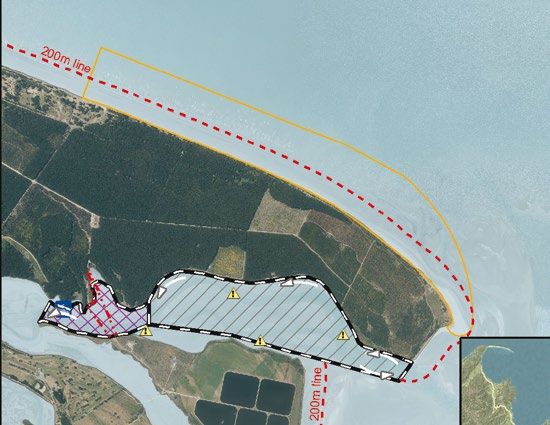
26 27TATA BEACH TOTARANUI
• Public toilets and boat launching ramps are available at Tata Beach and • DOC toilets and two boat launching ramps are nearby.
nearby Tarakohe. • This area provides waterskiing at all stages of the tide, but is exposed to the
• There is a waterski access lane here. Swimmers and other users should stay effects of the sea breeze and southerly sector winds.
out of the lane when skiing is happening nearby. • There is a waterski access lane here. Swimmers and other users should stay
• This area provides waterskiing at all stages of the tide, but is exposed to the out of the lane when skiing is happening nearby.
effects of north sector winds, including the sea breeze. • All vessels must be travelling at less than 5 knots shoreward of the yellow
• All vessels must be travelling at less than 5 knots shoreward of the yellow buoys.
buoys , including between and shoreward of the Tata Islands. • Be vigilant for swimmers and give them plenty of room.
• Be vigilant for swimmers and give them plenty of room.
WARNING: The channel to the boat ramp in the inlet is a popular swimming
• The free boat ramp at Tata Beach is exposed to the northwest and location for children. 5 knots maximum speed and extreme caution is
sometimes unsafe to use, especially on summer afternoons. An alternative required. The beachfront ramp becomes dangerous in strong easterly winds,
(fee applies) ramp is at nearby Tarakohe Harbour. and vessels may have to stand off shore until the tide allows use of the inlet
• NOTE: Dogs are prohibited from Tata Beach during daylight savings and for boat ramp.
the rest of the year for the hour before and the hour after dawn.
WARNING: The Totaranui, Awaroa and Mutton Cove beaches have the
highest rates of vessel swampings and capsizes in the District. Anchor with
MAP LEGEND: care. Only nose into the beach in calm conditions.
MAP LEGEND:
Dogs are prohibited from Tata Beach during daylight savings
and for the rest of the year for the hour before and the hour Dogs are prohibited in the National Park.
after dawn.
28 29TORRENT BAY THE ANCHORAGE
• Toilets are near the lagoon jetty at the southern end of the beach. • Toilets are in the nearby DOC camp and at Torrent Bay.
• Waterskiing is only permitted in this area one hour either side of Port Nelson • There is a waterski reserved area, although it can be used to access the
high tide each day. greater Torrent Bay area to the northeast.
• This is a waterski reserved area. • This area provides waterskiing at all stages of the tide, but is exposed to the
• Swimmers, kayakers or other vessels not immediately involved in effects of northerly sector winds including the sea breeze.
waterskiing must keep out of the area when it is in use for waterskiing. • A three-knot “Go slow “ zone is 100 metres to the east of this waterski area.
• Please do not trespass on private property. Please take care that your wake does not affect moored or anchored boats.
• This beach dries extensively at low tide. Beware of being stranded. • An Access Point Transit Lane has been put in place for the area shown in
red above, maximum speed is 5 knots, please minimise wake as this lane is
adjacent to the designated anchoring area.
MAP LEGEND:
• Yachties are reminded that lifejackets must be carried when using tenders.
MAP LEGEND:
Note: Dogs are prohibited in the nearby National Park. Note: Dogs are prohibited in the National Park.
30 31STILWELL BAY ADELE ISLAND SANDSPIT
• DOC toilets are nearby. • There are no toilets on Adele Island. The nearest toilets are at Stilwell Bay or
• There is a waterski access lane here. Swimmers and other users should Apple Tree Bay.
stay out of the lane when skiing is happening. • A waterski area is on the south side of the sandspit (which only appears
• The lane provides beach access at all stages of the tide, but is exposed below half tide). It is exposed to the effects of southerly sector winds and
to the effects of the sea breeze and southerly sector winds. Space on the stronger northerly sector breezes. Vessels may be anchored or pulled on to
beach becomes restricted or disappears completely on spring high tides. the beach on the north side of the sandspit only.
• A 3 knot “No Wake“ zone is located on the north side of the sandspit.
WARNING: Rocks are covered and uncovered by sand movement in this
area so the beach and inshore area should be carefully checked before • Yachties are reminded that lifejackets must be carried when using tenders.
starting to waterski. Do not trespass on private property above the beach. WARNING: Be aware that kayakers may suddenly appear around the end
of the sandspit. The area to the east of the ski area contains rocks that
MAP LEGEND: cover and uncover with the tide.
MAP LEGEND:
MARAHAU
A corridor is marked with yellow buoys from the boat ramp to the low
tide mark. This is intended for use by tractors towing boats to and from
the water and is not recommended for navigation by boats except at high
tide. The larger buoys mark the designated launching points. Take care for
scoured holes at these points. Launching vehicle use is at own risk.
Waterskiers and kitesurfers in particular are reminded that there is no
access lane at Marahau, so any beach starts and landings should be at Note: Dogs are prohibited in the National Park, at Adele Island
and from Otuwhero Inlet and the sandspit at Marahau.
walking pace (5 knots) until 200m from shore. The speed limit is also 5
knots in Otuwhero Inlet.
32 33KAITERITERI BAY STEPHENS BAY
The Kaiteriteri ski area is reserved for priority use by water skiers during the four hour Public toilets and a beach launching (small boat) ramp is available at Stephens Bay (there is
period between two hours before high tide, until two hours after high tide (see the also another small beach launching ramp available at nearby Tapu Bay).
tide tables in the centre section of this brochure) and only when marked out with black All vessels must be travelling at less than 5 knots shoreward of the yellow buoys
posts with white bands, a series of black buoys with white stripes may also be in place to
mark out the ski area boundaries. The period of marking may extend from about Labour Be very vigilant for swimmers and give them plenty of room.
Weekend until around the end of daylight savings the following year. Outside of these Stephens Bay is exposed to the East, anchor with caution and consider using the Kaiteriteri
times the reserved area status is revoked and the normal rules apply, see pages 13 -15. (fee applies) ramp in Easterly (or Northerly) conditions.
• Water skiing can also take place outside of the reserved area and outside of 200 meters
from the coast in Tasman Bay to the east. MAP LEGEND:
• Public toilets are at the ramp end of the Motor Camp street frontage and at the
Tasman District Council reserve at Little Kaiteriteri.
• Try to avoid launching and retrieving from the Kaiteriteri ramp during spring low tides
due to the low ramp angle and surrounding rocks.
• PWCs (Jetskis) are prohibited from towing waterskiers within the waterski area.
• PWCs (Jetskis) may not be operated at over 5 knots in Kaiteriteri Bay.
• Kayaks and swimmers may not use or pass through the waterskiing area when it is in use.
• Boats may not pass through the swimming area at any time.
• Vessels may not anchor unattended in either of the access lanes.
• Use of moorings should be arranged through the Kaiteriteri Beach Camp office.
WARNING: Rotation direction in Kaiteriteri is anti-clockwise for waterskiing to meet national
standards. Beware of swimmers caught in the tidal current from the estuary during ebb tides.
Swimmers should note the advice in the “swimming” section of this pamphlet.
MAP LEGEND:
NOTE: Dogs are prohibited on the main beach at Kaiteriteri NOTE: Dogs are prohibited from the reserve during summer
and, in the summer months, on Little Kaiteriteri beach except months (1 December to 1 March) except between 5.00 and
between 5.00 am and 9.00 am. 9.00 am.
34 35You can also read