Bongil Bongil National Park - NSW NATIONAL PARKS & WILDLIFE SERVICE Plan of Management
←
→
Page content transcription
If your browser does not render page correctly, please read the page content below

NSW NATIONAL PARKS & WILDLIFE SERVICE

Bongil Bongil
National Park
Plan of Management

environment.nsw.gov.au
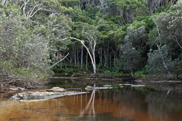
© 2021 State of NSW and Department of Planning, Industry and Environment
With the exception of photographs, the State of NSW and Department of Planning, Industry
and Environment are pleased to allow this material to be reproduced in whole or in part for
educational and non-commercial use, provided the meaning is unchanged and its source,
publisher and authorship are acknowledged. Specific permission is required for the
reproduction of photographs.
The Department of Planning, Industry and Environment (DPIE) has compiled this report in
good faith, exercising all due care and attention. No representation is made about the
accuracy, completeness or suitability of the information in this publication for any particular
purpose. DPIE shall not be liable for any damage which may occur to any person or
organisation taking action or not on the basis of this publication. Readers should seek
appropriate advice when applying the information to their specific needs.
All content in this publication is owned by DPIE and is protected by Crown Copyright, unless
credited otherwise. It is licensed under the Creative Commons Attribution 4.0 International
(CC BY 4.0), subject to the exemptions contained in the licence. The legal code for the
licence is available at Creative Commons.
DPIE asserts the right to be attributed as author of the original material in the following
manner: © State of New South Wales and Department of Planning, Industry and
Environment 2021.
Cover photo: Bundageree Creek, Bongil Bongil National Park. Shane Ruming/DPIE
This plan of management was adopted by the Minister for Energy and Environment on
6 May 2021.

Published by:
Environment, Energy and Science
Department of Planning, Industry and Environment
Locked Bag 5022, Parramatta NSW 2124
Phone: +61 2 9995 5000 (switchboard)
Phone: 1300 361 967 (Environment, Energy and Science enquiries)
TTY users: phone 133 677, then ask for 1300 361 967
Speak and listen users: phone 1300 555 727, then ask for 1300 361 967
Email: info@environment.nsw.gov.au
Website: www.environment.nsw.gov.au
Report pollution and environmental incidents
Environment Line: 131 555 (NSW only) or info@environment.nsw.gov.au
See also www.environment.nsw.gov.au
ISBN 978-1-922558-47-3
EES 2021/0129
May 2021

Find out more about your environment at:

www.environment.nsw.gov.au

Contents
1.   Introduction                                           1
     1.1   Location, reservation and regional setting        1
     1.2   Statement of significance                         3

2.   Management context                                     4
     2.1   Legislative and policy framework                  4
     2.2   Management purposes and principles                4
     2.3   Specific management directions                    5

3.   Values                                                 6
     3.1   Geology, landscape and hydrology                  6
     3.2   Native plants                                     8
     3.3   Native animals                                   12
     3.4 Aboriginal connections to Country                  14
     3.5 Shared heritage                                    15
     3.6 Visitor use                                        17

4.   Threats                                               26
     4.1   Pests                                            26
     4.2   Fire                                             31
     4.3 Plantations                                        32
     4.4 Climate change                                     33

5.   Management operations and other uses                  35
     5.1   Access                                           35
     5.2   Non-NPWS uses and operations                     37

6.   Implementation                                        40
Appendix A: Threatened and significant animal species recorded
   in the park                                              46
Appendix B: Major weeds recorded in the park               48
Appendix C: Ministerial roads in the park                  49

                                       iii
References 50
List of tables
Table 1 Threatened ecological communities mapped in the park 9
Table 2 Threatened and significant plant species recorded in the park 10
Table 3 Main day use areas in the park 19
Table 4 Walking tracks in the park 20
Table 5 Roads and trails allowed for horse riding 21
Table 6 Pest animals recorded in the park and their impacts 29
Table 7 North Coast climate change snapshot 34
Table 8 List of management responses 40
List of figures
Figure 1 Bongil Bongil National Park 1
iv[title]
Figure 1 Bongil Bongil National Park
1Bongil Bongil National Park Plan of Management
1. Introduction
1.1 Location, reservation and regional setting
Features Description
Location Bongil Bongil National Park (also referred to as ‘the park’ in this plan) is
located on the Mid North Coast of New South Wales. The northernmost part
of the park is 10 kilometres south of the city of Coffs Harbour, stretching
between the villages of Sawtell in the north, Mylestom in the south and
Valery to the west.
Area and The park was originally reserved in 1995 and the first plan of management
reservation for the park was adopted in 1999 (NPWS 2009) after extensive public
dates consultation (see Section 2.3). There have been a number of subsequent
additions to the park and the area of the park is now 4316 hectares. Park
additions to date:
• 978 hectares in December 1995
• 3156 hectares in July 2003
• 1 hectare in April 2004
• 97 hectares in July 2006
• 1 hectare in October 2007
• 83 hectares in February 2011.
The area covered by this plan includes a number of roads, land blocks and
essential service corridors that are vested in the Minister under Part 11 of the
National Parks and Wildlife Act 1974. This is to ensure continued access to
neighbouring land and to accommodate uses not closely aligned with nature
conservation e.g. powerline easements. These areas do not form part of the
reserved area of the park but their management is subject to this plan, the
National Parks and Wildlife Regulation and the requirements of the
Environmental Planning and Assessment Act 1979 (see Section 5.1).
The park is reserved to the mean low water mark along its eastern boundary
and therefore includes the intertidal zone along approximately 10 kilometres
of beachfront. This allows the NSW National Parks and Wildlife Service
(NPWS) to manage and regulate activities in the intertidal zone. The park
also protects over 100 hectares of creek bed on Pine and Bonville creeks
(see Figure 1 – area shown as ‘National park waters’) that has been
reserved as part of the park. This plan of management applies to these lands
but does not prohibit any action authorised under the Fisheries Management
Act 1994.
Previous tenure The first stage of the establishment of the park in 1995 followed the
acquisition of freehold lands at Bonville Beach (including large areas of
eucalypt plantation), coastal Crown land and part of Pine Creek State Forest
including Bundagen Flora Reserve.
Major additions were made in 2003, as a result of the North East Regional
Forest Agreement that included 2786 hectares of Pine Creek State Forest
being added to the park under the National Park Estate (Reservations) Act
2003. Also in 2003, 361 hectares were added to the park from freehold and
Crown land. These areas included freehold land north of Bonville Creek
(including the Bongil Day Use Area) and a small area of freehold land south
of the creek around the Pine Creek Trail area.
Also included in these additions was approximately 9 hectares of Crown land
previously managed by Coffs Harbour City Council. This addition was for
land at the mouth of Bonville Creek and included part of the bed of Bonville
Creek. In 2006, there was a delayed transfer of land of 97 hectares from the
1Bongil Bongil National Park Plan of Management
Features Description
National Park Estate (Reservations) Act. As part of the additions in 2011, 71
hectares (land north of Reedys Forest Road) was added to the park as
compensatory habitat purchased by the NSW Government to offset
biodiversity impacts associated with the Pacific Highway upgrade.
Regional context
Biogeographic The park lies within the NSW North Coast Bioregion and the Coffs Coast and
region Escarpment Subregion (Thackway & Cresswell 1995). The park is at the
eastern end of an almost complete corridor of conserved and forested public
lands linking New England National Park to the coast through Bellinger
River, Dorrigo and Bindarri national parks.
Surrounding Neighbouring land uses include: Pine Creek State Forest; grazing lands; a
land use large multiple-occupancy residential community, Bundagen Cooperative;
rural residential land; and high, medium and low density urban residential
land.
Other authorities The park is located within the areas of the Coffs Harbour and District Local
Aboriginal Land Council, North Coast Local Land Services, and Coffs
Harbour City and Bellingen Shire council areas.
2Bongil Bongil National Park Plan of Management
1.2 Statement of significance
Bongil Bongil National Park is significant because of the following values:
Landscape and catchment values
The park protects important coastal wetlands, creeks and estuaries that are crucial habitat
for many native plant and animal species.
In the 2019-20 bushfires, substantial areas of parks in this region were burnt. The fires did
not impact Bongil Bongil National Park, increasing the significance of the park for protection
of plant and animal species and habitat.
Biological values
The park has a diverse range of vegetation, including threatened ecological communities
such as Littoral Rainforest and Swamp Sclerophyll Forest on Coastal Floodplains. It protects
some highly significant and restricted species such as the koala (Phascolarctos cinereus),
little tern (Sternula albifrons), Floyd’s grass (Alexfloydia repens), rainforest cassia (Senna
acclinis) and provides breeding habitat for an endangered butterfly, the black grass-dart
(Ocybadistes knightorum).
Aboriginal connections to Country
The park is part of Country for the Gumbaynggirr People. While a few discrete sites are
formally recorded, numerous additional sites are predicted to occur in the park including
midden sites along undisturbed sections of the coastline.
Historic heritage
The majority of the park has an extensive history of timber-getting, with various forms of
physical evidence of this prior land use, including an old forestry workshop, depot at Grandis
Camp, remains of the Pine Creek Public School and an old forestry dormitory that is now
holiday rental accommodation known as Tuckers Rocks Cottage.
Recreation and tourism opportunities
The park provides low-impact recreational opportunities such as bushwalking, cycling,
fishing, beach walking, birdwatching, canoeing and limited opportunities for horse riding. It
also provides coastal holiday rental accommodation at Tuckers Rocks Cottage.
Research opportunities
There are opportunities in the park for research on rehabilitation and regeneration,
particularly in the former plantations and areas disturbed by sandmining.
3Bongil Bongil National Park Plan of Management
2. Management context
2.1 Legislative and policy framework
The management of national parks in New South Wales is in the context of a legislative and
policy framework, primarily the National Parks and Wildlife Act and Regulation, the NSW
Biodiversity Conservation Act 2016 and the policies of NPWS.
Other legislation, strategies and international agreements may also apply to management of
the area. In particular, the Environmental Planning and Assessment Act may require
assessment of the potential environmental impact of works proposed in this plan. The NSW
Heritage Act 1977 may apply to the excavation of known archaeological sites or sites with
potential to contain historical archaeological relics. The Commonwealth Environment
Protection and Biodiversity Conservation Act 1999 may apply in relation to actions that
impact matters of national environmental significance, such as migratory and threatened
species listed under that Act.
A plan of management is a statutory document under the National Parks and Wildlife Act.
Once the Minister has adopted a plan, the plan must be carried out and no operations may
be undertaken in relation to the lands to which the plan relates unless the operations are in
accordance with the plan. This plan will also apply to any future additions to the park. Should
management strategies or works be proposed in future that are not consistent with this plan,
an amendment to the plan will be required.
2.2 Management purposes and principles
National parks are reserved under the National Parks and Wildlife Act to protect and
conserve areas containing outstanding or representative ecosystems, natural or cultural
features or landscapes or phenomena that provide opportunities for public appreciation,
inspiration and sustainable visitor or tourist use and enjoyment.
Under section 30E of the National Parks and Wildlife Act, national parks are managed to:
• conserve biodiversity, maintain ecosystem functions, protect geological and
geomorphological features and natural phenomena and maintain natural landscapes
• conserve places, objects, features and landscapes of cultural value
• protect the ecological integrity of one or more ecosystems for present and future
generations
• promote public appreciation and understanding of the park’s natural and cultural values
• provide for sustainable visitor or tourist use and enjoyment that is compatible with
conservation of natural and cultural values
• provide for sustainable use (including adaptive re-use) of any buildings or structures or
modified natural areas having regard to conservation of natural and cultural values
• provide for appropriate research and monitoring.
The primary purpose of national parks is to conserve nature and cultural heritage.
Opportunities are provided for appropriate visitor use in a manner that does not damage
conservation values.
4Bongil Bongil National Park Plan of Management
2.3 Specific management directions
The first plan of management for the park was adopted in 1999, following extensive
community consultation. The management direction of that plan of management is reflected
in this plan, particularly in relation to the original sections of the park. This replacement plan
has been prepared to address matters specific to the additions to the park which have
occurred since 1999.
In addition to the general principles for the management of national parks (see Section 2.2),
specific management directions that apply to the park are:
• protect the habitat values of the park, particularly for threatened species such as the
koala, little tern, pied oystercatcher (Haematopus longirostris), Floyd’s Grass, black
grass-dart butterfly and six threatened ecological communities
• protect water quality, including the wetlands, creeks and estuarine environments
• rehabilitate degraded areas within the park to enhance their natural condition and the
habitat values they provide for a wide diversity of native plants and animals, including
continuing to implement the operations plan for rehabilitating former eucalypt plantations
in the park
• allow for continued access to neighbouring private property and state forest
• provide appropriate opportunities that enhance visitor experiences and opportunities
available on adjoining land tenures, such as cycling and horse riding
• protect the significant ecological values of the park from the damaging impacts of weed
invasion, pest animal predation, wildfire and inappropriate human use.
5Bongil Bongil National Park Plan of Management
3. Values
This plan aims to conserve both the natural and cultural values of the park. The location,
landforms and native plant and animal communities influenced how the area has been used
and valued by both Aboriginal and non-Aboriginal people. These values may be attached to
the landscape as a whole or to individual components, for example, to plant and animal
species used by Aboriginal people. To make the document clear and easy to use, various
aspects of natural heritage, cultural heritage, threats and ongoing use are dealt with
individually, although their interrelationships are recognised.
3.1 Geology, landscape and hydrology
The major geological types within the park are Quaternary sands and alluvium, and
Devonian and Permian metasediments. The dominant features of the coast are Holocene
sandy beaches and dunes. Undifferentiated Pleistocene sands and low-lying freshwater
swamps adjoin the dunes. Quaternary alluvium occurs in areas along the floodplains,
terraces, back-swamps and colluvial and alluvial fans of Pine and Bonville creeks (Pogson &
Hitchins 1973, cited in Cameron et al. 2011). The largely ephemeral creeks that transect the
hind dunes are well-developed and their morphology suggests they probably evolved during
the same period as the beach deposits.
There are two types of metasedimentary rocks in the park. In the south, Permian
sedimentary rocks or Nambucca Beds (Bellingen Slates) form low, rolling coastal hills. In the
North Bonville area, the underlying geology comprises younger Devonian sediments of the
Brooklana Beds and Moombil Siltstones (Pogson & Hitchins 1973, cited in Cameron et al.
2011). The Brooklana Beds are comprised of mudstone, siltstone, minor wacke, chert, jasper
and metabasalt. The Moombil Siltstone is comprised of massive siltstone, minor wacke and
granular conglomerate.
The soil landscape can be divided into a number of groups: transferral, colluvial, erosional,
alluvial, deltic/estuarine, aeolian and barrier sand and beach/barrier. Soil types consist of
quartzose dune sands on the stable foredunes and quartzose beach sands, which is
unconsolidated sand either side of the dunes, and yellow earths (podosols) that occur along
the estuary flats and terraces of the creeks and other areas subject to inundation (Cameron
et al. 2011). On the undulating coastal hills, colluvial soils occur with Bellingen slate of the
Nambucca Beds. West of the Pacific Highway on steep slopes near Seaview Hill, there is a
colluvial landscape with metasediments of the Nambucca Beds. The majority of the park has
an elevation of less than 60 metres above sea level. Elevations rarely exceed 70 metres,
with the exception of Seaview Hill (170 metres) in the south-west. Some areas of the park
are regularly subject to flooding during and after high rainfall events.
The steep foothills west of the park are drained by numerous streams that flow onto the
coastal plain. These streams merge into watercourses such as Bonville Creek and Pine
Creek, or drain into swamp or wetland areas. Scrub Creek transects the parallel dune–swale
system behind the frontal dunes, but unlike other creeks within the park, has no apparent
permanent ocean outlet and is essentially a closed system.
Prior to 1999, an artificial causeway existed across Scrub Creek between Palm Crossing
Trail and Overhead Bridge Road, impeding the creek’s natural flow and drainage.
Environmental assessment and restoration of the creek was undertaken, including
excavation and removal of the causeway. Rectification work was also undertaken in 1988 at
a nearby location through the replacement of a damaged culvert on Souris Road in the
upper reaches of Scrub Creek. These works have re-established the natural function and
drainage pattern of Scrub Creek.
6Bongil Bongil National Park Plan of Management
Bonville Creek and Pine Creek, whose upper catchments sit outside the park, are regularly
impacted by storm events and flash flooding, which result in rapid changes to the creeks’
flow and siltation levels, particularly on the downstream stretches of Bonville Creek. In 2012,
heavy rainfall and surging seas led to a complete closure of Bonville Creek at the mouth.
This impounding of the creek’s discharge into the ocean led to water levels rising and partial
inundation of low-lying areas of the park and neighbouring properties. Coffs Harbour City
Council initiated, with NPWS support, some excavation and removal of sand build-up at the
mouth of Bonville Creek in an effort to alleviate the impacts of further flooding on some of
these lower-lying properties and to alleviate impacts on the threatened ecological
communities upstream (see Section 3.2). Such changes to flow patterns in Bonville Creek
have the potential to harm the breeding colony of little terns on the Bongil Spit and to affect
sensitive vegetation communities such as those providing habitat to Floyd’s grass in the park
through inundation and changes to habitat condition (see Sections 3.2 and 3.3).
From around the early 1950s to the mid-1970s a number of areas on the eastern coastal
fringe of the park were used for sand and associated mineral sands extraction. A number of
small sandmine pits remain at the eastern end of both Palm Crossing and Bongil Beach
trails within the park. While these areas are slowly and naturally rehabilitating, weed invasion
remains an issue. A second, longer mineral sands strip mine extended from the start of
Bongil Beach Trail to between Eastern and Western Peninsula trails, northward to the
junction of Bonville and Pine creeks. The impacts of these mining operations upon the park’s
hydrology are unknown.
Issues
• Storm events, siltation and flooding are likely to continue as ongoing issues for the park
and will affect hydrology of the creek systems (see also Section 4.4).
• Negative impacts on low-lying areas of high conservation value within the park can be
expected if the mouth of Bonville Creek closes again or if coastal storms push a new
mouth for Bonville Creek through the dunal barrier system, south of its existing location.
• Erosion and sedimentation of the park’s drainage networks and waterways may occur
sporadically due to the combined impacts of high rainfall events and land uses outside
the park.
Desired outcomes
• Existing water quality and the health of the park’s creeks and waterbodies is maintained.
• Historical sandmines and extraction areas within the park are restored.
• Park management activities cause minimal erosion.
Management response
3.1.1 Carry out trail and track maintenance in a manner that minimises erosion and
siltation of watercourses.
3.1.2 Monitor trails and other known erosion sites and take action if needed to minimise
impacts on water quality.
3.1.3 Liaise with neighbours and adjoining land management authorities to minimise the
impact of trail and road maintenance and adjacent land uses on water quality and
erosion in the park.
3.1.4 Work with Coffs Harbour City Council to maintain stormwater drains and related
infrastructure to minimise siltation in the park and associated waterways.
7Bongil Bongil National Park Plan of Management
3.1.5 Assist Coffs Harbour City Council with the re-opening of Bonville Creek mouth if
required.
3.1.6 Permit research opportunities to investigate the restoration and natural regeneration
of the historical sandmines and extraction areas within the eastern area of the park.
3.2 Native plants
The park protects a diverse range of plants, with over 670 plants recorded for the park
(Cameron et al. 2011). There are 33 different and distinct vegetation communities within the
park. Many of these have restricted distributions or are threatened. The distribution of
vegetation communities in the park is strongly influenced by climate, geology, aspect and
topographical position in metasedimentary areas; and by the influence and level of
inundation by floodwaters and tidal impacts in the creek and estuarine areas (Cameron et al.
2011). The disturbance history of the park has had a significant role in determining the
characteristics of vegetation communities, especially where intensive silvicultural treatments
and fire have been repeatedly applied.
From 2008 to 2011 a detailed vegetation survey and mapping project was undertaken for the
park by staff of the former Office of Environment and Heritage (OEH) (Cameron et al. 2011).
The project provides one of the most comprehensive vegetation studies for a park of this
size within the NSW parks network to date. The project produced a fine-scale vegetation
map incorporating full floristic surveys at 111 sites. The study has improved the knowledge
of the distribution and abundance of plant species and will aid biodiversity management.
The most common vegetation types in the park are Blackbutt – Flooded Gum – Turpentine –
Tallowwood Wet Sclerophyll Forest (22%) and Blackbutt – Turpentine – Tallowwood Grassy
Ferny Dry Open Forest (20%). Of the 33 vegetation communities mapped, 26 cover less
than 2% each. Some of the most restricted vegetation communities in the park include
Headland Brushbox Littoral Rainforest, Tantoon Tea-tree Shrubland, Scribbly Gum Sand
Forest, Dune Soak Shrublands and Saltwater Couch Saltmarsh (Cameron et al. 2011).
Blackbutt – Flooded Gum – Turpentine – Tallowwood Wet Sclerophyll Forest is widespread
throughout the forested areas of the park. Flooded gum (Eucalyptus grandis) dominates the
lower eastern section of the park and Sydney blue gum (E. saligna) naturally replaces this
species west of the Pacific Highway (except where it has been introduced in plantation
locations). The Blackbutt – Turpentine – Tallowwood Grassy Ferny Dry Open Forest is
widely distributed in drier forest areas, especially on more fire-susceptible ridge top
locations. In some parts of the park, this community is likely to be a result of frequent logging
and fire disturbance where the understorey layer of moist shrubs has been reduced
(Cameron et al. 2011).
Table 1 lists the six threatened ecological communities that cover 546 hectares of the park
(Cameron et al. 2011). Four main patches of Littoral Rainforest have been identified in the
park. They include a large area south of Bundagen Headland, one on the south-east side of
Bundageree Creek just north of Tuckers Rocks, another behind the dunes of Bongil Beach
adjacent to Bundagen Cooperative lands and one east of Scrub Creek. The Littoral
Rainforest between Tuckers Rocks and Bundagen Headland in the south of the park forms
the second largest area of this rare rainforest community remaining in the state and is also
one of the most floristically diverse.
8Bongil Bongil National Park Plan of Management
Table 1 Threatened ecological communities mapped in the park
Ecological community Area (ha) Dominant species
(short titles)
Swamp Sclerophyll Forest on 300 Broad-leaved paperbark (Melaleuca quinquenervia),
Coastal Floodplains willow bottlebrush (Callistemon salignus) and
swamp oak (Casuarina glauca)
Lowland Rainforest 129 Bangalow palm (Archontophoenix
cunninghamiana), maiden’s blush (Sloanea
australis), coachwood (Ceratopetalum apetalum)
and hairy-leaved bolly gum (Neolitsea dealbata)
Littoral Rainforest 1 82 Small-leaved lilly pilly (Syzygium luehmannii), pear-
fruited tamarind (Mischocarpus pyriformis subsp.
pyriformis), and myrtle ebony (Diospyros
pentamera)
Coastal Saltmarsh 20 Species present in certain areas include sea rush
(Juncus kraussii subsp. australiensis), saltwater
couch (Sporobolus virginicus var. minor),
Sarcocornia quinqueflora and Schoenoplectus
subulatus
Swamp Oak Floodplain Forest 17 Swamp oak with understorey saltmarsh species
Baumea juncea (Sporobolus virginicus), matgrass
(Hemarthria uncinata) and wig rush (Baumea
juncea)
Lowland Rainforest on 9 Maiden’s blush – white booyong (Argyrodendron
Floodplain* trifoliolatum) floodplain subtropical rainforest
1 Also listed as critically endangered under the Environment Protection and Biodiversity Conservation
Act.
Also of particular significance is a population of hoop pine (Araucaria cunninghamii) on Pine
Creek that is considered to be naturally occurring and thought to be the reason for the
naming of Pine Creek (A Floyd [botanist] pers. comm.).
The park has had a long history of timber harvesting and production, and a number of
hardwood eucalypt plantations were established before the park’s reservation. Some of
these areas are now being progressively managed in accordance with an operations plan for
their rehabilitation (NPWS 2007) (see Section 4.3).
There is a need to provide suitable habitat trees for koalas, particularly in previously
disturbed areas. It is thought that flooded gum is over-represented in the area and the key
tree species for regeneration should focus on tallowwood and swamp mahogany (E.
robusta), which are thought to be the main habitat species for the koala (Millard 2012).
There are a number of former plantation sites within the park that consisted of introduced
species such as slash pine (Pinus elliottii), and native species not endemic to the area,
including hoop pine and Gympie messmate (E. cloeziana). Most of these plantations have
been subject to treatment, including removal of mature trees and, where possible, sale of the
harvested timber. These sites remain the focus of weed control activity as soil-stored seed
germinates.
Two critically endangered, seven endangered and four vulnerable species listed under the
Biodiversity Conservation Act have been recorded in the park (see Table 2). One species,
scented acronychia (Acronychia littoralis) is also listed as threatened under the Environment
Protection and Biodiversity Conservation Act.
9Bongil Bongil National Park Plan of Management
Table 2 Threatened and significant plant species recorded in the park
Common name Scientific name BC Act status Significance 1
Aniseed tree Anetholea anisata Rare and
restricted
Arrow-head vine Tinospora tinosporoides Vulnerable
Brown fairy-chain orchid Peristeranthus hillii Vulnerable
Floyd’s grass Alexfloydia repens Endangered
Green elf orchid Acianthella amplexicaulis Rare
Nambucca ironbark Eucalyptus fusiformis/ancophila Rare and
restricted
Narrow-leaved milk vine Marsdenia fraseri Rare
Native guava Rhodomyrtus psidioides Critically
endangered
Rainforest cassia Senna acclinis Endangered
Red-flowered king of the Oberonia titania Vulnerable
fairies
Rusty plum Niemeyera whitei Vulnerable
Sand spurge Chamaesyce psammogeton Endangered
Scented acronychia 2 Acronychia littoralis Endangered
Scrub turpentine Rhodamnia rubescens Critically
endangered
Slender marsdenia Marsdenia longiloba Endangered
Slender screw fern Lindsaea incisa Endangered
Spider orchid Dendrobium melaleucaphilum Endangered
1 Significance based on classification by Briggs & Leigh 1996.
2 Also listed as endangered under the Environment Protection and Biodiversity Conservation Act.
Floyd’s grass is a restricted species known from the forested floodplain wetlands bordering
Pine and Bonville creeks in the park. It has a range restricted to the Coffs Harbour to
Macksville regions of New South Wales. Floyd’s grass is the sole known food plant and
provides critical breeding habitat for the endangered black grass-dart butterfly (NSW SC
2002). The park is known to contain 73 individual patches of Floyd’s grass with a total
combined area of 16 hectares (Cameron et al. 2011).
Slender screw fern has been recorded at three localities in the north of the park, with all
records occurring at the base of foot slopes where clay-based soils meet damp sandy soils.
This species is endemic to the North Coast and records in the park represent the known
southern limit of the species (Cameron et al. 2011).
Scented acronychia is a medium-sized tree found in scattered locations on sand close to the
beach south of Sawtell. A significant population of the rare rainforest cassia was found in
2002 on and around Bundagen Headland. This population is found on both the thin strip of
the park in this locality and on the adjacent Bundagen Cooperative lands.
The four orchids listed in Table 2 (brown fairy-chain orchid, red-flowered king of the fairies,
spider orchid and green elf orchid) are all found either in or around Floyd’s grass habitat or in
the park’s Littoral Rainforest communities. Strategies for the recovery of some threatened
species, populations and ecological communities have been set out in a statewide
Biodiversity Conservation Program (OEH 2017). These actions are currently prioritised and
10Bongil Bongil National Park Plan of Management
implemented through the Saving our Species program, which aims to maximise the number
of threatened species that can be secured in the wild in New South Wales for 100 years
(OEH 2013a). Individual recovery plans for species listed under the Commonwealth
Environment Protection and Conservation Act may also be prepared for threatened species
to consider management needs and address species decline. Numerous recovery plans for
NSW threatened species have been prepared and provide information on species’
requirements, life cycle needs and habitat requirements.
A number of species in Table 2, including the threatened scented acronychia, rainforest
cassia, sand spurge and slender marsdenia, are coastal fringe-dwelling species that may all
be significantly affected by bitou bush (Chrysanthemoides monilifera subsp. rotundata)
invasion and are highlighted as key species to protect under the bitou bush threat abatement
plan (DEC 2006).
Issues
• The potential for future impoundment of the Bonville Creek/Pine Creek estuary may lead
to prolonged inundation of numerous threatened ecological communities and species,
including Floyd’s grass and black grass-dart habitat.
• Weed invasion is an ongoing threat to the native plants in the park (see Section 4.1),
and priority species for control include broadleaf paspalum (Paspalum mandiocanum),
lantana (Lantana camara), bitou bush, glory lily (Gloriosa superba) and blue billygoat
weed (Ageratum houstonianum).
• Floyd’s grass is located in some locations close to walking tracks and is threatened by
trampling and unauthorised mountain biking, particularly adjacent to the North Bank
Walk.
• Floyd’s grass is also found at the northern end of Burma Road. It is impacted by cars
driving over it. NPWS proposes restricting vehicle access at the end of the road and
encouraging people to walk the last section (see also section 3.6).
• The large areas (660 hectares) of hardwood plantations within the park are generally in
poor ecological condition, with poor forest structure and low species diversity. These
areas present significant restoration and rehabilitation issues for park managers.
• Flooded gum is over-represented in the area due to previous plantation activities. There
is a need to ensure tallowwood and swamp mahogany are re-established to improve
species diversity and to assist with providing key habitat trees for the koala.
Desired outcomes
• Populations of significant plant and ecological communities are conserved.
• Negative impacts on threatened species are minimised.
• The habitat and populations of all threatened plant species are identified, protected and
maintained.
• Structural diversity and habitat values are restored in degraded areas, including priority
areas for koalas and plantation sites.
Management response
3.2.1 Implement relevant recovery actions in the Biodiversity Conservation Program for
threatened species, populations and communities occurring in the park. Strategies
include: survey and map populations, control weeds and manage visitor impacts in
known habitat, and prevent fire wherever possible from entering Floyd’s grass
habitat.
11Bongil Bongil National Park Plan of Management
3.2.2 Continue to undertake weed control in priority areas including Littoral Rainforest and
Lowland Rainforest areas, and in Floyd’s grass habitat.
3.2.3 Investigate options to rehabilitate existing hardwood plantations to improve ecological
function where possible. Ensure key species used for rehabilitation include
tallowwood and swamp mahogany, which are important habitat trees for koalas.
3.2.4 Encourage natural regeneration of previously cleared areas. Monitor vegetation
recovery and assist natural regeneration if required.
3.3 Native animals
The park has a high diversity of animal species, with over 259 species recorded. Forty-eight
of these are considered threatened or otherwise significant (see Appendix A). Of these, 31
are birds (shorebirds, migratory, owls), 11 are mammals (arboreal, seals, bats), three are
amphibians (frogs), two are invertebrates (a butterfly and a giant dragonfly) and one is a
reptile (sea turtle). This animal diversity relates to the variety of vegetation types that provide
a wide range of habitats for these species.
In spite of this diversity, it is notable that there are only a few individual recordings of many
of the rare forest birds (e.g. forest owls). It is considered probable that populations of these
species, arboreal mammals such as greater gliders (Petauroides volans), yellow-bellied
gliders (Petaurus australis) and brush-tailed phascogales (Phascogale tapoatafa), and other
hollow-dependent species are reduced.
This reduction is likely due to the park’s history of intensive logging and silvicultural
practices. In forests managed for timber and firewood production, silvicultural practices have
greatly reduced the density of hollow-bearing trees, especially where repeated harvesting
events have occurred (Lindenmayer et al. 1991a, Smith et al. 1994, Ross 1999, all cited in
NSW SC 2011b). Culling of mature trees to reduce competition with younger, production
trees has specifically targeted large hollow-bearing trees (OEH 2007). Populations of hollow-
dependent animals are predicted to recover as the forest ages. The density of hollow-
bearing trees will gradually increase until reaching an equilibrium of recruitment and loss,
albeit possibly with a long time lag in some areas (NSW SC 2011b).
The koala is one of the most important animal species found in the park and its presence
was one of the main arguments used in the campaign to secure the Pine Creek State Forest
additions as part of the state’s protected area network. The koala population between
Bellinger River, Red Rock and Guy Fawkes River National Park has statewide significance
as one of the three major concentrations of koala records in north-east NSW (Smith 1997).
There have been more than 250 individual records for koalas for the park. In 1995–96 the
koala population in the original Pine Creek State Forest area was estimated to be between
340 and 450 animals (State Forests 2000).
In the mid-1990s there was increasing awareness of the importance of the koala population
in the Pine Creek area and local community concerns were growing about the impacts of
ongoing timber harvesting on the species (State Forests 2000). Before the additions to the
park in 2003, a koala management plan for Pine Creek State Forest was prepared to allow
for continuation of harvesting operations while proposing interim protection for areas of core
koala habitat, specifically those forest associations with a high proportion of tallowwood, the
koala’s preferred food species on the NSW North Coast.
Local volunteers have been dedicated to the protection of koalas in the park and surrounding
land for many years. They have monitored koalas in the park and assisted with advice and
protection measures for this species. They have collaborated with Australian Museum
Business Services to investigate impacts of the Pacific Highway realignment on koalas and
on ongoing monitoring of impacts associated with this development.
12Bongil Bongil National Park Plan of Management
In 2013 a community koala survey program was designed and implemented within core
koala habitat in the park (NPWS 2014). The purpose of the program is to replicate the
methodology over many years, thereby determining a measure of relative abundance for this
species in the park.
The park also contains the site of the most important little tern breeding colony on the NSW
North Coast, the third most productive in the state.
The Bongil little tern nesting site recovered from the brink of localised extinction in 1996, with
successful little tern breeding occurring from 2000. Since 1998, local volunteers have taken
on the role of wardens, checking the site daily during the breeding season and educating
people about the threats to these birds.
The little terns nest annually over spring and summer at the northern sand spit at the mouth
of Bonville Creek (see Figure 1). The colony is threatened by disturbance from humans,
predation from foxes (Vulpes vulpes) and feral cats (Felis catus), wild and domestic dogs
(Canis lupus subspp.) and by native animals such as goannas (Varanus spp.) and forest
ravens (Corvus tasmanicus).
The Bongil Spit is now being used by breeding pairs of pied oystercatchers, another
endangered species of shorebird found within the park. Numerous pairs of this species have
successfully raised young within the protective little tern breeding compound over recent
years. Occasional sightings of the critically endangered beach stone-curlew (Esacus
magnirostris) have also been recorded on the Bongil Spit over recent years.
The park is also important for birds listed under the Environment Protection and Biodiversity
Conservation Act including waders and birds listed under the China–Australia Migratory Bird
Agreement (CAMBA), Japan–Australia Migratory Bird Agreement (JAMBA) and Republic of
Korea – Australia Migratory Bird Agreement (ROKAMBA), with 14 migratory bird species
recorded in the park (see Appendix A). All species listed under CAMBA, JAMBA and
ROKAMBA recorded within the park are listed under the Environment Protection and
Biodiversity Conservation Act.
Other significant species recorded in the park include two endangered invertebrate species:
the black grass-dart (a butterfly), and the coastal petaltail (Petalura litorea) which is a giant
dragonfly.
The park is key habitat for the black grass-dart, which is only found on the Mid North Coast
between Diggers Headland at Coffs Harbour and Warrell Creek (just south of Macksville), in
places where its sole known food plant, Floyd’s grass, occurs (see Section 3.2) (NSW SC
2002).
The coastal petaltail dragonfly is a highly restricted species known from coastal locations
between Coffs Harbour and Ballina. This record for the park is the southern limit for this
species (M Andren pers. comm.). The main threats to these species’ habitats are sea level
rise, weed invasion and human disturbance (Andren & Cameron 2012).
It is also highly likely the park contains the giant barred frog (Mixophyes iteratus), which is
listed as endangered under the Biodiversity Conservation Act and the Environment
Protection and Biodiversity Conservation Act. This species is yet to be recorded in the park,
but suitable habitat is found around Pine Creek west of the highway and in permanent or
near-permanent pools on the larger tributaries.
As for native plants, strategies for the recovery of threatened animal species, populations
and ecological communities are set out in the statewide Biodiversity Conservation Program
(OEH 2017) and are prioritised and implemented through the Saving our Species program
(OEH 2013a). Individual recovery plans that consider management needs in more detail may
be prepared for species listed under the Commonwealth Environment Protection and
Biodiversity Conservation Act. Numerous recovery plans for NSW threatened species (e.g.
13Bongil Bongil National Park Plan of Management
koala, little tern, large forest owls and yellow-bellied glider) have been prepared and provide
information on species’ requirements, life cycle needs and habitat requirements.
Issues
• Breeding shorebirds, including the little tern and pied oystercatcher, are threatened by
disturbance from foxes, humans, domestic and wild dogs, and predation of eggs by
some feral and native animals.
• The koala is a key species for the park. Old plantations and degraded areas of the park
need to be rehabilitated to improve habitat for this species.
• There is a need to protect the black grass-dart, which is restricted to the Coffs Harbour
area, and its sole food plant, Floyd’s grass.
Desired outcomes
• Significant animal species and populations are conserved.
• Negative impacts on threatened species are minimised.
• The habitat and populations of all threatened animal species are protected and
maintained.
Management response
3.3.1 Implement relevant recovery actions in the Biodiversity Conservation Program and
relevant recovery plans for threatened animal species and populations occurring in
the park. Strategies include: conduct surveys, control weeds and feral animals,
ensure appropriate fire regimes, rehabilitate wetlands, protect breeding sites and
undertake targeted fox and wild dog control.
3.3.2 Continue to protect little terns and their breeding sites through measures such as
pest species control, habitat protection, public education and the interpretation and
monitoring of the site by volunteers and NPWS staff.
3.3.3 Continue to restore koala habitat and food trees through controlling threats such as
weeds and too-frequent fires.
3.3.4 Continue to support volunteers who are engaged in monitoring species in the park,
such as little terns and koalas.
3.3.5 Continue to support the annual community koala surveys.
3.3.6 Promote education programs on native animals, particularly the needs of shorebirds
and waders and species sensitive to human disturbance.
3.3.7 Maintain habitat of the black grass-dart in Floyd’s grass areas through weed control
and exclusion of fire.
3.3.8 Encourage research in the park on koalas, little terns, Floyd’s grass, coastal petaltail
dragonflies and pied oystercatchers.
3.4 Aboriginal connections to Country
The park lies within the traditional Country of the Gumbaynggirr People and the area of the
Coffs Harbour and District Local Aboriginal Land Council. The land, water, plants and
animals within a landscape are central to Aboriginal spirituality and identity. Aboriginal
communities associate natural resources with the use and enjoyment of foods and
medicines, caring for the land, passing on cultural knowledge, kinship systems and
14Bongil Bongil National Park Plan of Management
strengthening social bonds. Aboriginal heritage and connection to Country are inseparable
and need to be managed in an integrated manner across the landscape.
Bongil bongil was the term used by the local Gumbaynggirr People to describe this ‘place
where one stays a long time’ because of the abundance of food.
Around 1880 the area that is now the park supported a group of about 180 people camping
together in groups of about 30 individuals for the greater part of the year. At certain times of
the year large groups would congregate to exploit the seasonal resources of the area and
participate in ceremonies.
Aboriginal sites are places with evidence of Aboriginal occupation or that are related to other
aspects of Aboriginal culture. They are important as evidence of Aboriginal history and as
part of the culture of local Aboriginal people.
Several Aboriginal sites have been identified within the park that contain artefacts including
middens, a modified tree and stone tools. There is a high probability that more sites occur on
the sand dunes and estuary shores.
While the NSW Government has legal responsibility for the protection of Aboriginal sites and
places, NPWS acknowledges the right of Aboriginal people to make decisions about their
own heritage. Aboriginal communities will be consulted and involved in the management of
Aboriginal sites, places and related issues; and in the promotion and presentation of
Aboriginal culture and history.
Desired outcomes
• Aboriginal sites, including non-tangible sites, are identified and protected.
• Aboriginal people are involved in management of the Aboriginal cultural values of the
park.
• Impacts on Aboriginal heritage values are minimised.
• Understanding of the cultural values of the park is improved.
Management response
3.4.1 Continue to consult and engage Coffs Harbour and District Local Aboriginal Land
Council, Elders groups, other relevant Aboriginal community organisations and
custodial families in the management of their Country, including through further
survey, research and management of Aboriginal sites, places and cultural and
natural values.
3.4.2 Undertake an archaeological survey and cultural assessment prior to all works that
have the potential to impact Aboriginal sites or values.
3.4.3 Provide opportunities for Aboriginal people to access Country to maintain, renew or
develop cultural practices and associations.
3.5 Shared heritage
Heritage places and landscapes are made up of living stories as well as connections to the
past that can include natural resources, objects, customs and traditions that individuals and
communities have inherited and wish to conserve for current and future generations. Cultural
heritage comprises places and items that may have historical, scientific, cultural, social,
archaeological, architectural, natural or aesthetic significance. NPWS conserves the
significant heritage features of NSW parks and reserves.
15Bongil Bongil National Park Plan of Management
Timber harvesting was undertaken throughout the area from the 1860s. The forest has
contributed significantly to the development and financial strength of the Bellingen and Coffs
Harbour areas and its timber industry (State Forests 2000). There are numerous historic
relics in the park that reflect this forestry era.
There are a number of log loading ramps and large stumps with stand-board slots, which
generally indicate that trees had been felled manually by broad axes. Most of the park roads
were old log haulage routes, built by the early loggers.
The park contains some remains of the local Pine Creek Forestry Depot and workshop at
Grandis Camp. A former forestry cottage at Tuckers Rocks (now known as Tuckers Rocks
Cottage) originally provided dormitory accommodation for forestry workers (see Figure 1). It
was thought to have been built in the 1940s and has since been renovated, expanded, and
converted to holiday accommodation (see Section 3.6).
On the headland at Tuckers Rocks is a memorial cairn dedicated to Edward Lindsay (Len)
Hudson, a former Forestry Commissioner from 1948 to 1952 (Australian National University
2015).
The remains of the old Pine Creek School, including a hearth and a concrete slab, are still
visible at the intersection of School and Souris roads in the park. Pine Creek School was
operational from around 1920 to 1945 (J Formann [resident] pers. comm.). This school
provided education for children from local timber and farming families, such as the Formann
and Souris families. The park area also supported a number of local timber mills, including
one on Spring Tank Trail and a sleeper cutting operation on Tuckeroo Trail (both trails now
dormant) near Tuckers Rocks.
An important part of the park’s history lies in the story of its reservation. The area’s
reservation as national park is largely the result of efforts from local conservationists, who
campaigned extensively against logging operations and the likely impacts on the local koala
population. A number of members of the Bundagen Cooperative and other locals were also
instrumental in assisting in the expansion of the park.
Bundagen Flora Reserve, which was previously part of Pine Creek State Forest, was
dedicated as a flora reserve in 1985 following the recommendations of a committee
representing the interests of the parks, forestry and conservation authorities, scientific
bodies and mining companies (FCNSW 1989). There was an advisory committee
established to oversee the management of this reserve while it was under State Forests
NSW (now Forestry Corporation of NSW) management.
Intensive mining of mineral sands over the past 50 years has modified extensive areas of the
beach ridge system by levelling the hind dune areas (in some places inverting the soil
profile), and subsequent planting of native species not endemic to the Coffs Coast such as
coastal tea tree (Leptospermum laevigatum).
Some areas of the park were previously parts of rural properties used for grazing and other
industries. There are some heritage items remaining in certain areas, including Williams
Farm along Williams Road, north-west of Bongil Day Use Area. Here the old dairy bales,
some concrete footings, a well, water tank and fruit trees remain. A second family farm,
owned and operated by the Formann family, existed on the corner of Souris and Overhead
Bridge roads within the park, north-west of Palm Crossing Day Use Area. This area was
ploughed up and the old family farm house destroyed during the establishment of an
Australian Paper Mills eucalypt plantation on the site in 1971. Fence posts marking the
western edge of one of the Formann family’s prior grazing paddocks remain on the eastern
side of Souris Road near Scrub Creek. The Formann family were reportedly one of the first
settlers in the area to try commercial banana growing in the 1920s. This plantation was
established east of the farmhouse on a slope dropping from clay ridge substrate down onto
the sand plain (J Formann [resident] pers. comm.).
16Bongil Bongil National Park Plan of Management
Holiday cabins and a ramshackle collection of caravans and humpies previously existed on
the western edge of the peninsula along the lower east bank of Pine Creek. These were
removed when the area was sandmined.
These cabins were reportedly managed by the State Rail Authority and were periodically
occupied by recuperating railway workers injured while at work. The remains of a timber jetty
connected to this prior use can be seen at low tide on the eastern bank of Pine Creek (J
Burke [relative of Sid Burke] pers. comm; and Floyd 1990, cited in Cameron et al. 2011).
The Sid Burke Day Use Area is located off the Pacific Highway. The site was originally
created by the then Roads and Traffic Authority as a highway rest stop. The area was
reserved as part of the 2003 additions to the park. The area is named after Sid Burke, a
forestry foreman who spent much of his working life in Pine Creek State Forest.
The Sid Burke Day Use Area includes a memorial made of an old bullock-drawn steel log
cradle. It commemorates the work of three generations of the local Burke family in the
logging industry.
Before any works are undertaken, the likely impacts of any operational activities on known or
suspected historic sites or places within the park require cultural assessment and possible
further archaeological investigation.
Issues
• Wildfire has the potential to burn away old tree stumps displaying stand-board slots.
• The area’s rich oral history is unrecorded.
Desired outcomes
• Negative impacts on shared heritage values are minimised.
• Understanding of the cultural values of the park is improved.
• Significant historic features are appropriately conserved and managed.
Management response
3.5.1 Record and assess historic sites in the park and manage them in accordance with
their assessed level of significance.
3.5.2 Support the recording of oral histories relating to the park, in particular those relevant
to the identification and protection of heritage sites.
3.6 Visitor use
NPWS parks and reserves provide a range of visitor opportunities. NPWS aims to ensure
that visitors enjoy, experience and appreciate the parks while park values are conserved and
protected. Day use facilities are provided in the park, primarily at the Bongil Day Use Area
and Sid Burke Day Use Area. Additional smaller day use areas are located at The Bluff on
Bluff Loop Trail (near Tuckers Rocks), at Big Bend on the North Bank Walk (east of the
Bongil Day Use Area), and Palm Crossing on Palm Crossing Trail (in the central coastal
section of the park). See Figure 1. Current visitor experiences include bushwalking, fishing,
canoeing, cycling, four-wheel driving, horse riding, surfing, birdwatching, boating, running
and picnicking.
The park provides opportunities for visitation in a natural coastal setting which includes
remote beaches, meandering creeks and flat bush trails.
17Bongil Bongil National Park Plan of Management
Most visitor activity in the park is concentrated at the river mouth on Bonville Creek, beach
areas at Tuckers Rocks, and the Bongil Day Use Area. Peak visitation occurs on the
weekends and in summer.
The close proximity of the park to expanding coastal towns such as Bellingen, Urunga,
Mylestom, Repton, Sawtell and the city of Coffs Harbour indicates that visitation to the park
is likely to continue to grow.
The park is mainly used by local residents with knowledge of the area and road networks.
However, because of its proximity to Coffs Harbour there is potential for it to be accessible
for a wider range of low-impact recreational activities by tourists and visitors to the region.
Cycling and canoeing are becoming more popular recreational pursuits in the park.
Holiday rental accommodation is available in the park at Tuckers Rocks Cottage (see
Accommodation section below) near North Beach. Although no camping is permitted in the
park, a wide variety of camping options are provided in neighbouring areas such as
Mylestom, Repton, Urunga, Sawtell and Coffs Harbour by private and commercial operators
and other agencies.
Cycling is very popular in the park and the neighbouring Pine Creek State Forest, particularly
in the area shown on Figure 1 as Pine Creek Mountain Bike Park (see Cycling section
below). NPWS is actively encouraging greater use of the national park by cyclists and a
number of management and public vehicle trails are identified in the park as suitable for a
variety of riders, including children.
Other areas managed by NPWS, other authorities and private operators in the region also
provide opportunities for a range of recreation activities. Neighbouring areas include Coffs
Coast Regional Park and Pine Creek State Forest.
Access
There is an extensive network of roads in the park that is currently used for a variety of
purposes including public access, recreation, park management, and facilitating access to
state forests, private property and apiary sites. Access to the main visitor areas, such as
Bongil and Sid Burke day use areas, and Tuckers Rocks area, are via sealed and unsealed
two-wheel drive all-weather roads (see Figure 1). There are also a number of roads that
traverse the park that are principally used to access private property or for forestry
operations in neighbouring state forest compartments (see Section 5.1).
The beach between Tuckers Rocks and Bundagen Headland is accessible to four-wheel
drive vehicles. Bellingen Shire Council maintains access to this area from Rutile Trail, which
runs off Christian Parade at Mylestom. Vehicles on the beach are restricted to the intertidal
zone and are not permitted north of Bundagen Headland or on the dunes. The northern limit
for access by four-wheel drives is the southern side of Bundagaree Creek. Driving in or
across the creek is not permitted. Driving on the rocky shelf of the headland is also not
permitted.
Due to reports of compliance breaches, four-wheel drive access to the beach within the park
will be routinely monitored and reviewed. The reviews will assess the impact of four-wheel
driving on the beach and foredunes, particularly on vegetation communities, animal species,
and known and potential Aboriginal sites and values, and the level of conflict with other
beach users. The review will also assess compliance with the requirements to keep within
the intertidal zone of the beach, and to limit vehicles on the beach to the area south of
Bundagaree Creek. If four-wheel driving on the beach within the park is assessed by NPWS
to be having unacceptable impacts on the environment or beach users, or if four-wheel
drivers are found to be consistently using areas not open to four-wheel drive vehicles,
access to the beaches within the park may be limited or closed by regulation. This will not
impact on or change commercial fishers’ access.
18You can also read