BRIDGEFOOT STREET PARK DESIGN RATIONALE - LANDSCAPE ARCHITECTURE - PART 8 APPLICATION JULY 2017 - Dublin City Council Consultations
←
→
Page content transcription
If your browser does not render page correctly, please read the page content below
DERMOT FOLEY LANDSCAPE ARCHITECTS

BRIDGEFOOT STREET PARK
DESIGN RATIONALE - LANDSCAPE ARCHITECTURE

PART 8 APPLICATION                  JULY 2017
DERMOT FOLEY LANDSCAPE ARCHITECTS

Contents
1.     Introduction
2.     Planning Context
3.     Consultation Process
4.     Site
5.     History
6.     Landscape Design Proposals

                                    2/26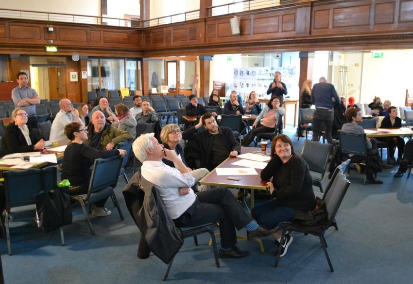
DERMOT FOLEY LANDSCAPE ARCHITECTS
1 Introduction
Bridgefoot Street Park is proposed as a major new public open space for the Liberties and the city
of Dublin. It has the potential to transform this part of Dublin and to act as a major resource for
local residents, other citizens and tourists who are visiting the area in increasing numbers.
The purpose of this document is to describe the subject site, the design team’s response to the
site as well as the design proposals for new landscape and external works for the park. This
planning application also includes an Archaeological Impact Statement, prepared by Linzi Simpson
Archaeology.
The following drawings, prepared by Dermot Foley Landscape Architects (DFLA), accompany this
document:
Drawing No. Title Scale
Dc.21_200 Site Location 1:1000 @ A3
Dc.21_201 Landscape Plan 1:250 @ A1
Dc.21_240 Landscape Sections 1 1:100 @ A1 extended
Dc.21_241 Landscape Sections 2 1:100 @ A1 extended
Dc.21_270 Artist’s Impression NTS @ A2
A unique collaborative process was initiated between the client, Dublin City Council Parks
Department, Dublin City Council Local Area Office, other stakeholders and members of the public
and the design team, DFLA. A series of public consultations were held over an extended time
period. The design proposals illustrated in this document and the accompanying drawings,
emerged directly from the consultation process. The proposals express the input of all involved.
The landscape architects (DFLA) in partnership with the Parks and Landscape Services also
consulted with other Dublin City Council departments including Roads & Traffic, Planning,
Archaeology, Access, Architecture, Conservation, Biodiversity and the Local Area Office.
The following statutory and other documents were used to inform the proposals:
Dublin City Development Plan 2016 - 2022 (published by Dublin City Council)
Dublin City Public Realm Strategy, 2016 (published by Dublin City Council)
The Liberties Greening Strategy (Draft), 2014 (published by Dublin City Council)
3/26
DERMOT FOLEY LANDSCAPE ARCHITECTS

2        Planning Context

The Dublin City Development Plan 2016 – 2022 zones the site Z9, with objectives to ‘preserve,
provide and improve recreational amenity and open space and green networks’. The Liberties
Greening Strategy (2014) classifies Bridgefoot Street Park as ‘Community Grade 1’ – ‘serving
local communities with a good range of amenities and a high standard of design and horticultural
presentation’.

The Dublin City Public Realm Strategy (2016) identifies the site as close to the ‘Civic Spine and
Liffey Corridor’ which is ‘the most important series of streets and spaces in the city’, as well as a
series of Secondary Streets and Linking Routes.

In terms of the immediate context, outside of the planning application boundary, The Liberties
Local Area Plan (2009) recommends improved street crossings to allow safe access for Oliver
Bond residents, as well as a link to the Digital Hub to the south-west of the site.

It is evident that the subject site is widely acknowledged as having the potential to play a key role
in the inner city; providing improved access, permeability and enjoyment for locals and visitors
alike.

Generally, the planning documentation acknowledges a relative lack of usable public open space
in the Liberties. Much of the space available is associated with religious grounds, cemeteries and
churches. The area has the potential to cater for a dynamic local community, growing in diversity,
and a burgeoning tourist population. Dublin City Council publications support the proposition that
Bridgefoot Street Park could play a prominent role as both an enhanced public open space and a
node within a network of amenity spaces in the local urban fabric.

                                                                                                        4/26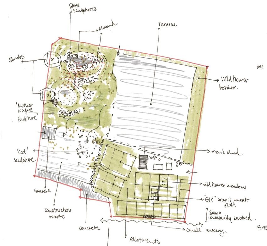
DERMOT FOLEY LANDSCAPE ARCHITECTS

3      Consultation Process

The site has a rich history of community involvement which continues today, in the form of the
community gardens, workshops and events. Local community groups have organized informal
events in order to bring local people together on site, as well as creating sculptures out of existing
material on site. With assistance from Dublin City Council, the park has the potential to meet a
wide range of needs expressed by members of the public. These include increased integration,
permeability, accessibility and passive supervision. These are key design considerations upon
which the design of the park is based.

The proposals for Bridgefoot Street Park are a result of the very close collaboration between
client, design team and members of the public. A series of consultations were held on 22nd April
2016, 23rd April 2016, 20th April 2017 and 15th June 2017.

3.1        Consultation 1 – Held on 22-23rd April 2016

Consultation 1 (two workshops) was organised in collaboration with landscape architects at the
School of Architecture Planning and Environmental Policy, University College Dublin (UCD). The
workshops were held on site on Friday and Saturday. Students from UCD assembled a series of
art installations (Fig.1). Attendees, members of the public, local residents, young and old,
participated in a practical exercise where they were asked to represent their vision of the park by
cutting and pasting elements onto a site plan (Fig.2). These ideas and compositions were then
collected by the design team and assessed quantitatively (Fig.3). The results were summarized in
a table, which was then used to inform the future consultation process. Attendees also got the
opportunity to walk the site and get an understanding of the size of the space and the topography
and built context.

                                                                                                         5/26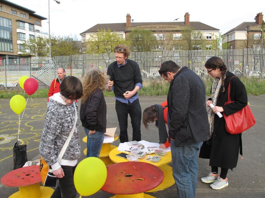
DERMOT FOLEY LANDSCAPE ARCHITECTS

Figure 1: UCD students assembling a series of art installations on site.

Figure 2: Attendees participating in the practical exercise organized to gather visions and compositions for the new park.

                                                                                                                             6/26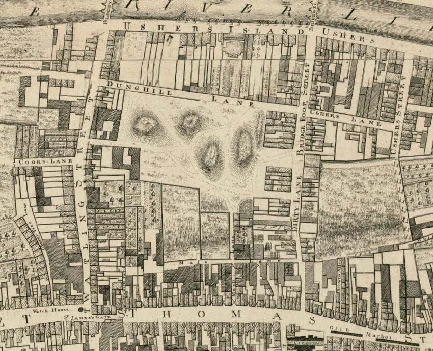
DERMOT FOLEY LANDSCAPE ARCHITECTS

Figure 3: Some of the material collected as a result of the vision and composition ‘cut and paste’ exercise.

                                                  th
3.2          Consultation 2 – Held on 20 April 2017

The two following consultations were held in St. Catherine’s Church, Thomas Street. The first of
these took place on 20th April. The consultation was hosted twice, in the morning and again in the
evening, in order to facilitate as many people and as wide a mix of participants as possible. It
comprised of two exercises designed to give an insight into participant preference. For the first
exercise attendees were asked what they would like to see and do in the park. Opinions were
recorded and analyzed. The findings were summarized in a diagram which illustrated the main
themes that emerged from that process. These themes are Multifunctional Space (multi-
functionality), Open and Inviting Space (openness), Space that is Natural (nature) and Space for
All Ages (flexibility), and are highlighted in red on the image below (Fig.4).

                                                                                                               7/26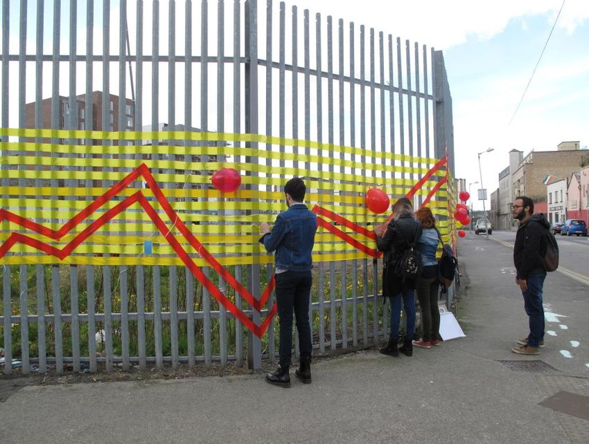
DERMOT FOLEY LANDSCAPE ARCHITECTS

                                                                                          th
Figure 4: Diagram illustrating the main themes emerging from the consultation process on 20 April 2017.

The second exercise related more specifically to potential elements within the park, such as
furniture, materials and art installations. The participants were asked to review a series of images
and select the ones that they found most appealing (Fig.5). Images depicting open air events, use
of natural topography, creative play and organic form were found to be most popular. Combining
the results of both exercises produced a picture of a multi-layered landscape; an inviting park that
brings the community together, with an ability to adapt over time.

Based on the findings of the second consultation, DFLA created a video which interpreted and
summarised the consultation and was distributed on social media. The video was well received
and the design team went on to develop a sketch landscape design proposal for the park.

                                                                                                          8/26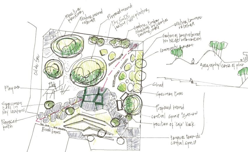
DERMOT FOLEY LANDSCAPE ARCHITECTS

Figure 5: Participants were asked to review a series of images as part of the consultation process. Two examples are
included above.

3.3          Consultation 3 – Held on 15th June 2017

The sketch landscape design proposal was exhibited at the third consultation. A presentation was
made to illustrate how the design development was generated in response to the previous
consultations. The presentation included printed copies of the sketch plan and artist impression as
well as an on-screen analysis of the drawings to explain how the main themes of the previous
consultations generated the spaces and character of the proposals (Fig.6). This was followed by a

                                                                                                                       9/26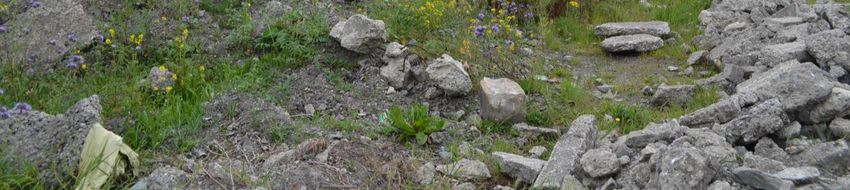
DERMOT FOLEY LANDSCAPE ARCHITECTS

short practical demonstration of the strategy for the future community involvement with the park.
Students and teachers from the Liberties Community Training Center have agreed to engage with
the design team to put their skills into practice in designing and building prototype furniture and
other elements for the park.

A lively discussion was generated and the participants were also asked to give their opinions and
comments in the form of written feedback. Feedback was generally positive, nonetheless
comments have been carefully considered and where possible incorporated in the current design
proposal. The client and design team were happy to progress the design further and proceed with
the official Part 8 application.

Figure 6: Attendees were shown the design development which had been generated in response to previous
consultations.

                                                                                                         10/26
DERMOT FOLEY LANDSCAPE ARCHITECTS
4 Site
The site is bound by Bridgefoot Street on the east, Island Street on the north, Bonham Street on
the north-west and Robert Emmet Walk on the southern side (Fig.7). It is relatively open and
moderately exposed. The current boundary consists of a tall steel fence and the historic
Marshalsea Wall to the north-west. Bridgefoot Street Park is located between two major arteries of
the city, Thomas Street (to the south) and the Quays (to the north). There is the possibility to
improve additional connections; activating Oliver Bond Street and Watling Street and linking with
the Digital Hub nearby.
Figure 7: Site location plan showing site boundary in red.
11/26DERMOT FOLEY LANDSCAPE ARCHITECTS
Currently the site is a brownfield site, situated on a north-facing shallow slope. The slope offers
possibilities for terracing and other spatial devices. Consideration has been given to provide
universal accessibility (Fig.8).
Hard materials include an extensive area of tarmacadam, rubble and construction waste material
(secondary raw material) left in-situ and colonized by ruderal and native vegetation (Fig.9). The
local community has set up a number of art installations along the western side of the site. These
include small stone and rubble sculptures, as well as larger land art interventions (Fig.10).
Figure 8: Diagram showing analysis of existing conditions.
12/26DERMOT FOLEY LANDSCAPE ARCHITECTS
Figure 9: Existing hard landscape materials and surfaces on site.
.
Figure 10: Existing art installations developed by members of the local community.
13/26DERMOT FOLEY LANDSCAPE ARCHITECTS
5 History
The history of the site is richly layered. The park is within the Zone of Archaeological Potential for
the historic town of Dublin. The site was generally undeveloped until after the thirteenth century
when the Dominican Order arrived in Dublin and set up a monastery on the north side of the river
(just east of Church Street). A school was established on the south side of the river, in the vicinity.
The location of the site in the Record of Monuments and Places is believed to be at the junction of
Island Street and Bridgefoot Street in the north-east corner of the site. In the Early Modern Period,
the area was still quite undeveloped. There is evidence that Bridgefoot Street came about as an
informal route with the building of Ellis’ Bridge. Rocque’s map of 1756 shows a number of dung-
heaps, suggesting the site was then used as a municipal dumping ground (Fig.11). In later years,
the Marshalsea Prison was built as a debtor’s prison. It was a large complex laid around two
courtyards. In the 19th century it was used by Robert Emmet as an arsenal while the Dublin Militia
used it as barracks. Additional buildings were added to the compound. The gaol was demolished
in 1875, but a part of the external wall remains intact to this day. It forms the south western
boundary to Bridgefoot Street Park. Please refer to the Archaeological Impact Statement,
prepared by Linzi Simpson Archaeology.
Figure 11: Roque’s map 1756, showing dung-heaps on the location of the site.
14/26DERMOT FOLEY LANDSCAPE ARCHITECTS
6 Landscape Design Proposals
The landscape proposals have been developed in response to the public consultation process,
which as previously mentioned, formed the basis of the design. An emphasis has been placed on
the four main topics identified – multi-functionality, openness, nature and flexibility. Particular
attention has been paid to the ability of the park to adapt over time and transform in accordance
with the needs and demands of the users.
6.1 Approach and Interpretation
The core philosophy adopted by the design team is one which focuses on the primacy of a vision
that will provide a spatial harmony and at the same time possess a particular ambiance that will
enhance the area for generations to come. The spatial conception is based on a methodical
design process that identifies what is unique about the area, pays attention to the demands of the
public and takes into account the feasibility of ideas. It is envisaged that the park could represent
an addition to a network of existing and future experiences, using contrasting spatial devices to
create a sequence between the interface of the site and the surrounding urban fabric. Through the
various consultation processes a series of core activities have emerged which helped to determine
the spatial arrangement and outcome of the site. It is important to note that a flexible approach
has been adopted to the way spaces and activities in the park cross-over and provide resilience to
future change.
6.2 Design Development and Spatial Sequence
Of vital importance is the creation of an ambiance that will provide the user with an experience that
will enrich one’s occasional visit and/or everyday life. A number of designated spaces have
emerged in the design, following on from the consultation process. These include flexible use
open space, allotments and community gardens, café space, terraced performance area, passive
recreation and informal and formal play. A series of sketch designs have been developed,
exploring different locations of these elements (Fig.12). Considering the overall spatial sequence
of the site, a final layout was generated (Fig.13). It strikes a balance between permanent
interventions as well as more temporary and flexible uses for the park.
15/26DERMOT FOLEY LANDSCAPE ARCHITECTS
Figure 12: A range of sketch plans and options produced as part of the design process.
16/26DERMOT FOLEY LANDSCAPE ARCHITECTS
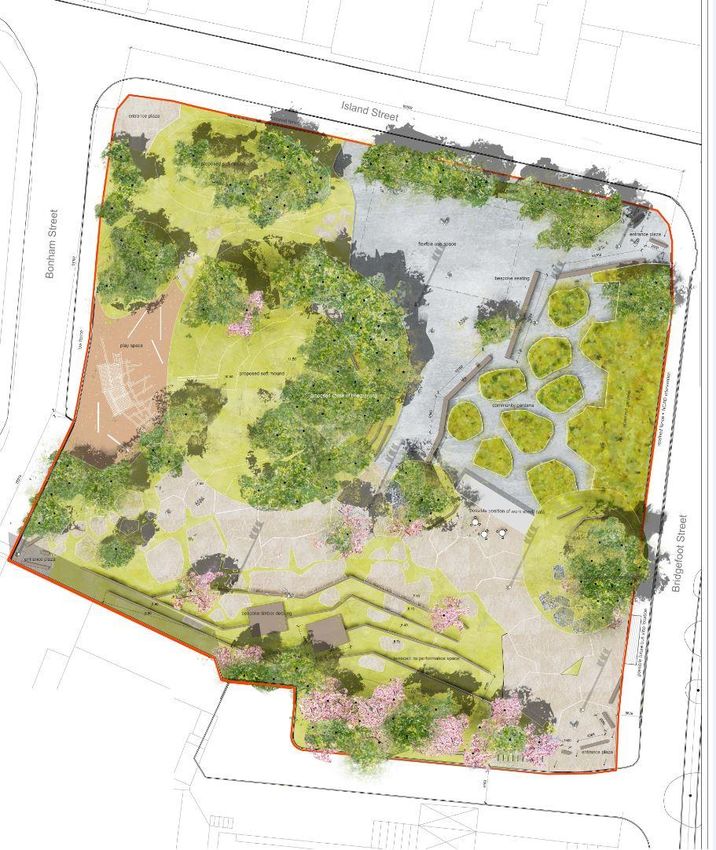
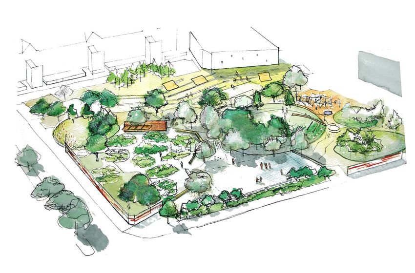
Figure 13: Proposed Landscape Plan. NTS.
17/26DERMOT FOLEY LANDSCAPE ARCHITECTS
Figure 14: Diagram showing the proposed spatial sequence within the park. NTS.
The existing tarmacadam surface to the north-east of the site has been transformed into a flexible
use open space which has the potential to accommodate organized community activities, ball
games as well as occasional markets and exhibitions.
The existing community garden will be re-located to the south-eastern portion of the tarmacadam.
The surface would be broken up and cut out in organic shapes, to create a playful community
garden space. A portion of the existing steel fence will remain intact and will serve to enclose the
space. A number of individual allotments will be provided on the periphery also. The approach of
the design team is that the allotments as they are currently on site are a rather positive feature to
18/26DERMOT FOLEY LANDSCAPE ARCHITECTS
the existing park space. It is the designer’s intention that this atmosphere is cherished and
preserved. The overshadowing of the existing building to the north of the site would no longer be
an issue. A small structure will be provided which will act as a tool shed on one side. There will be
potential for it to serve as a small café on the other side. An enclosed space has been provided
which would be suitable for the location of a number of coffee tables and chairs.
Taking advantage of the existing topography of the site, a terraced performance space has been
designed to the south.
The entire western side has been allocated for play. It is proposed that a formal playground is
located there. A low fence has been introduced to ensure security for the children at play. Informal
play opportunities will be provided all over the site. Nonetheless a higher concentration of those is
located in the western side of the park. A series of mounds cater for different spatial experiences.
Large boulders, slides and steps would be incorporated into these mounds in such a way as to
encourage children to engage with the landscape.
The ‘landmark’ for Bridgefoot Street Park is the large grassy mound in the middle of the site. It is
proposed to be over four metres high and be seen from outside of the site boundary. It will
incorporate various uses: informal play, as previously mentioned, as well as space for passive
recreation and relaxation (Fig.14).
6.3 Boundaries, Access and Lighting
Generally the park is intended to be open. It is a part of the design strategy that fences and
enclosures are kept to the minimum so as to create a feeling of receptiveness. Only small portions
of the existing steel fence will be retained. It is the designer’s intention to initiate collaboration with
the students of the National College of Art and Design nearby. They will be given the opportunity
to turn the remaining fences into art installations, as well as use them to exhibit their work in the
future (Fig.15). The main access points to the park are at the four corners of the site. It is a goal to
encourage walking and cycling as the preferred means of movement within the city. Bicycle
parking will be provided near site entrances. Within the park, circulation includes direct routes
through as well as possibilities of meandering paths and recreational walks (Fig.16).
19/26DERMOT FOLEY LANDSCAPE ARCHITECTS
Figure 15: Diagram showing site boundaries. NTS. Boundaries include retained portions of the existing steel fence as
well as proposed vegetation.
20/26DERMOT FOLEY LANDSCAPE ARCHITECTS
Figure 16: Diagram showing circulation and access on site. NTS. Access points are located at each corner of the park.
Main circulation routes are shown in blue. More informal routes are shown in brown. All routes are proposed to be fully
accessible.
Careful consideration has been given to universal accessibility. A ramped route has been provided
to the top of the central mound in the park. All other areas are gently sloping and have been
designed in a way as to cater for a wide range of users. If required a Disability Proofing Report will
be completed at the tender stages of the design process.
Lighting has been designed to ensure security and usage of the park when daylight hours are
restricted. The main route through will be lit up. The formal playground area will also be fully lit up
to accommodate play even during the winter months (Fig.17).
21/26DERMOT FOLEY LANDSCAPE ARCHITECTS
Figure 17: Diagram showing lighting strategy on site. NTS. Areas to be lit are shown in green. The main play area (left
hand side of the plan) is proposed to be lit to allow parents to bring their children to the play area in the early evening
during spring and autumn. The route from the south-west to the north-east is proposed to be lit as is the route from the
southwest to the southeast.
6.4 Topography and Importation of Material
The creation of new topography, together with substantial tree planting will generate an immersive
landscape which will give that ‘sense of place’ that all good parks express. New mounds are
proposed to extend the existing stockpiles of soil and other materials on site, which have been
colonized with native and ruderal vegetation. The mounds or ‘hills’ create sub-spaces for different
uses, but also unite the park and allow a large connected interstitial space to accommodate clear
access routes and large temporary events such as markets. It is intended to minimize excavation
on site and, therefore, it is estimated that approximately 2,000 cubic metres (135 truck loads) of
inert secondary raw material will be imported to the site to create new topography. Subsoil and
22/26DERMOT FOLEY LANDSCAPE ARCHITECTS
topsoil will also be imported where required for community gardens, allotments, lawns and tree
planting.
6.5 Hard Landscape Materials
The landscape design is intended to facilitate high visitor numbers, as well as be durable, robust
and take into account the specific context of the park. Existing tarmacadam will be retained. Other
hard surfaces include in-situ concrete and recycled construction waste, either found on site or
transported from elsewhere. Large recycled demolition waste boulders will also be used. They will
create informal play opportunities as well as varying spatial experiences.
Some of the furniture and other details are proposed to be made out of hardwood timber sleepers
and modified profiles and sections of the sleepers. The Liberties Community Training Centre has
already been engaged in the design and construction of furniture for the park. The trainees will be
given the opportunity to create durable and resilient pieces which should reflect local skills and
active engagement. The intention is that trainees will benefit personally, but that additionally there
would be an obvious tangible outcome of the community engagement process from the initial
stages of the design development. It is hoped that this process will contribute to a sense of
ownership and supervision which might assist in the prevention of antisocial behavior in the future.
6.6 Soft Landscape
The objective to maximize the ‘green’ character of the park has been of particular importance
during the consultation process. The landscape of the proposed park is seen as one rich in
biodiversity, which offers an alternative to the prevailing hard landscape character of the Liberties
and which can act as an ‘outdoor classroom’ for events and engagement in relation to ecology,
biodiversity and nature. Planting mixes have been considered and will be developed to ensure
high ecological value as well as a therapeutic environment for visitors and users. The design
proposals incorporate areas of mown lawn, managed long grass, bulb, herbaceous, groundcover
and swale planting, as well as hedges and trees.
It is important to note that spoil will not be taken off site, in order to prevent the potential spread of
invasive species, if found to be existing.
The proposed tree species have been selected for decorative, ecological and spatial
characteristics, diversity, seasonal interest, drama and engagement. Individual trees, as well as
copses and groups of trees are proposed in order to create a feeling of immersion in nature
(Fig.18). A variety of fruit trees and other flowering trees are also proposed to provide seasonal
23/26DERMOT FOLEY LANDSCAPE ARCHITECTS
interest, particularly around the perimeter of the park where they will be seen from the surrounding
streetscape.
The following is a list of the main proposed tree species or genera:
Hazel (usable, native, education, biodiversity)
Oak (native, education, biodiversity)
Larch (seasonal colour)
Scots Pine (native, education, biodiversity)
Cherry (flower, seasonal colour, native)
Apple (usable, flower, education)
Pear (usable, flower, education)
Magnolia (flower)
Hawthorn (native, flower, biodiversity, education)
Figure 18: Two examples of criteria against which trees are selected for the proposed park: Engagement (above), where
people can coppice and harvest material from trees such as hazel or fruit trees; Drama (below) where the habit and/or
seasonal colour of the tree, when used en-masse gives rise to feeling of immersion in nature.
24/26DERMOT FOLEY LANDSCAPE ARCHITECTS
6.7 Possible Future Works Outside Site Boundary, not forming part of this Application
Bridgefoot Street Park is acknowledged as a key node within an important network of roads and
spaces within the inner city. Some of the adjacent spaces and sites will be subject to future re-
development and the proposed development of the park will not preclude the development of the
future residential site at Bonham Street (west of the park) or any other sites or streets. The
elements in the park are designed and located with the overall context in mind, and to work
sympathetically with the future re-development of the Bonham Street site in particular.
On the eastern side of the site, at Bridgefoot Street, it would be possible in the future to reduce the
width of the road and extend the park to the central median. Improved pedestrian crossings would
also be considered to allow safe access for the residents of the Oliver Bond site towards the
proposed park. A Bus Rapid Transit (BRT) route may run along Bridgefoot Street. A bus-stop
could be accommodated at the park and the park could facilitate the BRT, even if extended to the
central median. The Liberties Local Area Plan also suggests the possible allocation of a Dublin
Bikes scheme along this side of the park (Fig.19).
25/26DERMOT FOLEY LANDSCAPE ARCHITECTS
Figure 19: Diagram showing the possible extension of the park to the east which would incorporate a possible future
BRT route on Bridgefoot Street. NTS. This proposal is not included in this planning application.
6.8 Construction Management & Removing Material from the Site
A construction management plan will be developed during the detail design stages. It is not
intended to export any material off the site. Site compounds will be located within the site
boundary, with access from Island Street and the existing steel boundary will be used to secure
the site for public safety until the last stage of construction when fences will be removed.
End.
26/26You can also read


