Briefing Materials Cincinnati, Ohio January 2019 - ULI Americas
←
→
Page content transcription
If your browser does not render page correctly, please read the page content below
Briefing Materials Cincinnati, Ohio January 2019
Contents

About the Sponsors....................................................................................................................................... 3
About the Competition ................................................................................................................................. 4
   Jury ............................................................................................................................................................ 5
   Eligibility .................................................................................................................................................... 5
2019 Competition Background: Cincinnati ................................................................................................... 6
   Introduction .............................................................................................................................................. 6
The Competition Challenge......................................................................................................................... 12
   Your Challenge ........................................................................................................................................ 15
Additional Context ...................................................................................................................................... 16
Detailed Assignment ................................................................................................................................... 23
   Assumptions............................................................................................................................................ 24
Competition Resources Checklist ............................................................................................................... 27
   How You May Use Downloaded Materials ............................................................................................. 27
Criteria for Judging ...................................................................................................................................... 27
Presentation Requirements ........................................................................................................................ 28
   Required Presentation Materials ............................................................................................................ 29
   Notes on Graphics ................................................................................................................................... 29
   Essential Presentation Elements............................................................................................................. 29
   Detailed Guidance on the Essential Presentation Elements................................................................... 30
Competition Logistics .................................................................................................................................. 32
   General Competition Schedule ............................................................................................................... 32
   Final Competition Schedule .................................................................................................................... 32
Submission Process ..................................................................................................................................... 32
Final Competition Requirements ................................................................................................................ 34
Questions .................................................................................................................................................... 34

                                                                                                                                                           2 of 34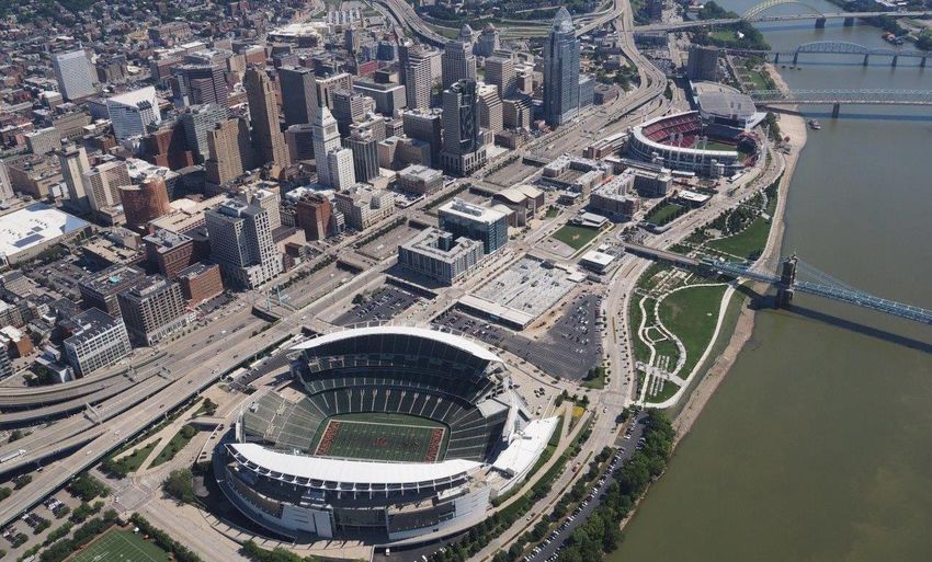
About the Sponsors
                          Hines is a privately owned global real estate investment, development, and
                          management firm, founded in 1957, with a presence in 207 cities in 24
                          countries and $116.4 billion of assets under management—including $64
billion for which Hines provides fiduciary investment management services and $52.4 billion for which
Hines provides third-party property-level services.

Hines has 109 developments currently underway around the world, and historically has developed,
redeveloped, or acquired 1,319 properties, totaling over 431 million square feet. The firm’s current
property and asset management portfolio includes 527 properties representing over 224 million square
feet. With extensive experience in investments across the risk spectrum and all property types, and a
pioneering commitment to sustainability, Hines is one of the largest and most respected real estate
organizations in the world.

                              The Urban Land Institute is a global, member-driven organization
                              comprising more than 42,000 real estate and urban development
                              professionals dedicated to advancing the Institute’s mission of providing
leadership in the responsible use of land and in creating and sustaining thriving communities worldwide.

ULI’s interdisciplinary membership represents all aspects of the industry, including developers, property
owners, investors, architects, urban planners, public officials, real estate brokers, appraisers, attorneys,
engineers, financiers, and academics. Established in 1936, the Institute has a presence in the Americas,
Europe, and Asia Pacific regions, with members in 81 countries. The extraordinary impact that ULI makes
on land use decision-making is based on its members sharing expertise on a variety of factors affecting
the built environment, including urbanization, demographic and population changes, new economic
drivers, technology advancements, and environmental concerns. Peer-to-peer learning is achieved
through the knowledge shared by members at thousands of convenings each year that reinforce ULI’s
position as a global authority on land use and real estate. In 2018 alone, 2,200 events were held in 330
cities around the world. Drawing on the work of its members, the Institute recognizes and shares best
practices in urban design and development for the benefit of communities around the globe.

More information is available at uli.org.
Follow ULI on Twitter, Facebook, LinkedIn, and Instagram.

                                                                                                    3 of 34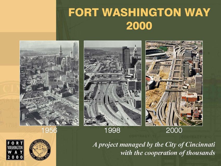
About the Competition

The ULI Hines Student Competition, now in its 17th year, is one of the core education initiatives of the
Urban Land Institute. The competition offers eligible students, enrolled in recognized programs, the
opportunity to form multidisciplinary teams and engage in a challenging exercise in responsible land
use. It is part of ULI’s ongoing education initiative to raise interest among young people in creating
better communities, improving development patterns, and increasing awareness of the need for
multidisciplinary solutions to development and design challenges.

Gerald D. Hines, founder and chairman of the Hines real estate company, was the 2002 recipient of the
ULI J.C. Nichols Prize for Visionaries in Urban Development. A firm believer in the power of people and
fostering transformative values, Hines declined the prize money and matched it to seed the annual ULI
Hines Student Competition. Since its founding, Hines endowed the program with an additional $3
million, ensuring its longevity and legacy for future generations of built-environment practitioners.

The competition has become a pivotal experience for students as they prepare for careers in the built
environment. Since the competition began in 2003, more than 8,610 students on over 1,720 teams have
participated. “The purpose of the competition is to raise awareness, particularly among the next
generation, of the important role that high-quality urban design plays in creating not just beautiful
buildings, but living environments,” Hines says. The competition encourages cooperation and teamwork
among future real estate developers and the many allied professions, such as architecture, landscape
architecture, historic preservation, engineering, finance, and others.

During the competition, teams of five students, representing at least three different disciplines pursuing
at least three different degree programs, apply to participate. Once ULI announces the host city and
challenge, the teams have two weeks to devise a comprehensive design and development program for
an actual large-scale site. Submissions consist of large-format presentation boards that include site
plans, renderings, infographics, and market-feasible financial data. Though based on real site conditions
and challenges, this competition is an ideas competition: there is no expectation that any of the
submitted proposals will be applied to the site. To view previous submissions and learn more about the
competition format, visit the competition archives at uli.org/hines.

The jury meets in person to evaluate all the entries, submitted anonymously, and over the course of two
intense days selects those teams receiving an honorable mention, and the four finalist teams that
advance to the second phase of the competition. One member of each finalist team receives a paid trip
to join a tour of the competition site and receive a briefing on it. Finalist teams also receive an additional
briefing to help them refine and expand their original proposals. All finalist team members receive an
all-expense-paid trip to meet in the host city for a live public presentation of their proposal and a Q&A
session with the full jury. After jury deliberations, the winning team is announced. The grand prize is
$50,000 ($5,000 of which goes to the team’s school), and the finalist teams receive $10,000 each.

                                                                                                      4 of 34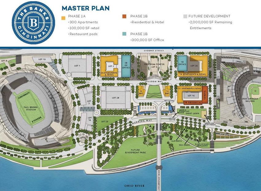
Jury

Reflecting the multidisciplinary nature of the competition, ULI selects 10 to 12 jurors from diverse
backgrounds to evaluate team submissions, choose four finalists, and ultimately select one winner from
among the finalists. While there is no official prescription for composition of the jury, past juries have
included a strategic mix of land use experts such as developers, brokers, architects, urban designers,
landscape architects, urban planners, and policy officials, among others. Several members of the jury are
also practitioners in the competition’s host city in order to ensure up-to-date knowledge of the site
challenges and the validity of the proposals.

In agreeing to serve as members of the competition jury, the jurors attest that they have reviewed the
competition program and agree to abide by the rules, regulations, and guidelines as stated. Jurors
typically serve in this capacity no more than twice. While ULI strives to select and publicize the jury
roster as soon as possible, there is no guarantee that ULI will disclose the jury composition before the
end of the submission period. For the latest information about each juror, visit the competition website,
uli.org/hines.

Eligibility

ULI invites the participation of teams from accredited educational institutions around the world. Teams
must be made up of graduate students pursuing a graduate degree while fully enrolled for the entire
academic period during which the competition is conducted. ULI allows the participation of part-time
graduate students and fifth-year students on the fifth year of a five-year program—most commonly
bachelor of architecture and bachelor of landscape architecture students—provided they meet specific
eligibility criteria as outlined in the competition guidelines.

Ineligible to compete are members of the jury; the competition advisers; all officials, current employees,
and recent former employees of ULI; the employees, students, and immediate families of any of these
parties; those whom ULI deems to have a conflict of interest; and all students from the finalist teams in
the 2017 and 2018 competitions.

ULI notified teams of their eligibility to compete by email no later than Friday, December 21, 2018.
ULI reserves the right to disqualify teams or to limit the number of teams allowed to participate in the
competition.

                                                                                                   5 of 34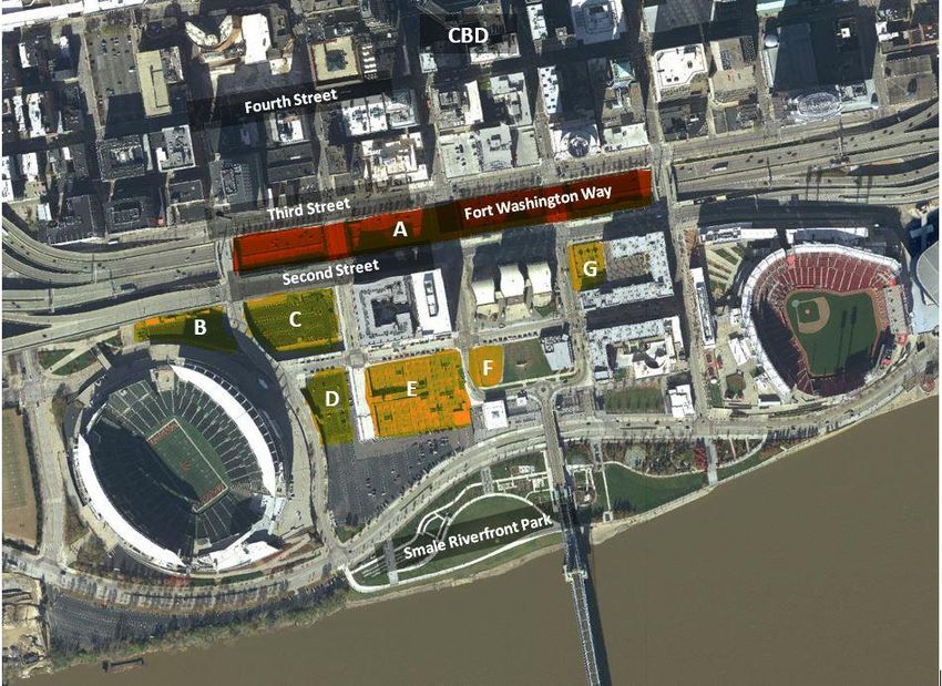
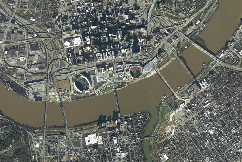
2019 Competition Background: Cincinnati

Figure 1. A view of the main competition site in 2018. (The Banks)

Introduction
                                       Perched on the north side of the Ohio River, Cincinnati offers
                                       midwestern ease and charm, plus a rich history of immigration and city
                                       building. Cincinnati was hailed as the Queen City of the West in its early
                                       days; one will still hear it called that today, as well as simply “Cincy.”
                                       Established in 1788 and incorporated in 1819, Cincinnati grew steadily
                                       through the first half of the 20th century, hitting a population peak of
                                       around 500,000. This growth included waves of immigrants, primarily
                                       from Germany and Ireland. With this influx, Cincinnati became the sixth-
                                       largest city in the United States through the 1840s and 1850s. In 2017,
                                       Cincinnati had an estimated population of 301,300, making it the 66th-
                                       most-populous city in the United States, and the third most populous in
                                       Ohio. The city is the county seat of Hamilton County and serves a larger
                                       population of 2.18 million in the Cincinnati–Middletown, OH-KY-IN
                                       metropolitan statistical area, which links southwest Ohio, northern

                                                                                                          6 of 34
Kentucky, and southeast Indiana.1 Greater Cincinnati is the 29th-most-populous metropolitan region in
the United States.

The City is, indeed, justly styled the fair Queen of the West: distinguished for order, enterprise, public
spirit, and liberality, she stands the wonder of an admiring world.
Ed. B. Cooke, May 1819

Riverfront
The core of Cincinnati developed along the riverfront, in the basin surrounded by the hills of the Mill
Creek Valley. Mill Creek flows south to where it meets the Ohio River, just west of downtown Cincinnati.
The Ohio River reaches 981 miles from Pennsylvania to Illinois, shapes the borders of five states, and is
the source of drinking water for 3 million people. In 1866, the historic John A. Roebling Suspension
Bridge—the longest suspension bridge in the world at the time—opened to span the river between
Covington, Kentucky, and Cincinnati. Its designer, John A. Roebling, also constructed the famed Brooklyn
Bridge across the East River in New York City. In 1975, the bridge was designated a National Historic
Landmark. The city’s riverfront facilitated the needs of travelers headed west on the river, the
manufacture and repair of steamboats, and agricultural trade, among other things. (For a fascinating
early image of the riverfront, visit the Cincinnati Panorama of 1848.)

Figure 2. Construction of the Roebling Suspension Bridge, 1865. (The Enquirer)

1
 Annual Estimates of the Resident Population: April 1, 2010, to July 1, 2017. Source: U.S. Census Bureau,
Population Division.

                                                                                                            7 of 34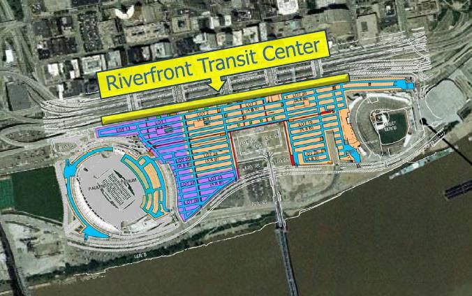
Civil War and the Underground Railroad
Before and during the Civil War, Cincinnati was a town on the border between the free state of Ohio and
the slave state of Kentucky. Despite significant pro-slavery sentiments within the city, Cincinnati played
a role in the abolitionist movement and was an important stop on the Underground Railroad, ushering
escaped slaves to freedom in the north. Many arrived at the city’s riverfront by boat and some settled in
the city and the region.
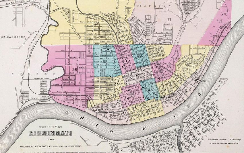
Figure 3. Cincinnati in 1856. The competition site is designated by the red circle. (David Rumsey Map Collection)2
Economy
At the beginning, Cincinnati was a center of riverboat trade, iron production, meatpacking, produce, and
even wine making. The Ohio River remains a driver of the local economy, handling more cargo than the
Panama Canal and hosting 52 barge facilities along its banks near Cincinnati. Many of the city’s German
immigrants settled in the Over-the-Rhine neighborhood north of the central business district (CBD) and
brought with them a variety of skills, including brewing. By the mid–19th century, 36 breweries were
producing over 30 million gallons of beer. Though Prohibition felled many of these enterprises, a
renaissance in the industry has produced an even greater number of breweries in the region today.
Cincinnati honors this heritage with the largest Oktoberfest celebration in America. Meanwhile, across
the river to the south, within a two-hour drive is the famed Kentucky Bourbon Trail, drawing nearly 1.2
million people per year.
2
Colton’s Atlas of the World, plate 40 detail, “The Cities of Pittsburgh and Allegheny (and) The City of Cincinnati,
Ohio,” published by J.H. Colton & Co., 1856. David Rumsey Historical Map Collection.
8 of 34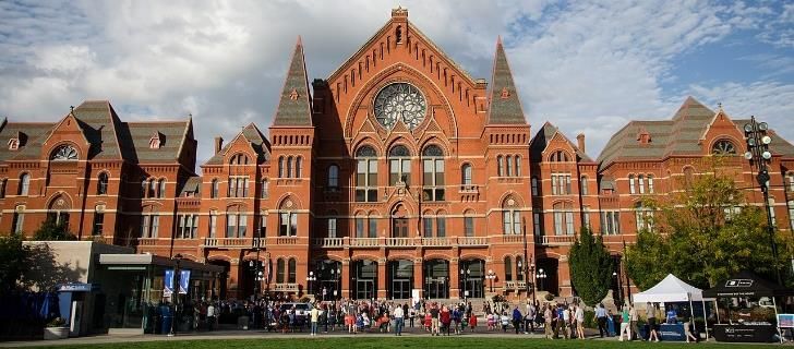
Greater Cincinnati hosts nine Fortune 500 companies and 450 foreign-owned companies. The biggest
employers in Cincinnati include Kroger (17th on the Fortune 500 list), General Electric (18th), Procter &
Gamble (42nd), and Macy’s (120th), as well as Cincinnati/Northern Kentucky International Airport and
various “eds and meds,” including TriHealth, Mercy Health, Cincinnati Children’s Hospital, the University
of Cincinnati, and University of Cincinnati Health. In a 2016 study, KPMG named Cincinnati “the most
cost-friendly city to do business” of the 31 largest U.S. metro areas because of its lower property taxes
and leasing costs.

The region also has one of the fastest-growing economies in the Midwest. In its 2014 data, the U.S.
Bureau of Economic Analysis (BEA) showed a 2.5 percent growth rate for the regional economy, 0.2
percentage point ahead of the national average. Growth in the professional and business services sector
fueled the area’s overall growth.

The 2018 edition of the Brookings Metro Monitor, which measures the progress of the nation’s 100
largest metropolitan areas on inclusive economic growth and prosperity, showed that while growth was
widespread among these communities between 2015 and 2016, the Cincinnati metropolitan area was
one of only 11 that achieved inclusive economic growth and prosperity, with improvements in every
measure.

ULI and Cincinnati

ULI’s own history finds its roots in Cincinnati. In 1936, Walter S. Schmidt became the first president of
the Institute’s predecessor organization, the National Real Estate Foundation for Practical Research and
Education. Schmidt then became ULI’s first chairman in 1940. Schmidt was born in Cincinnati in 1885
and died there in 1957 at age 72. His grandfather came from Germany during the 1890s, and his father
started the real estate company that he would take over when he was 26. Schmidt observed the decline
of central business districts in Cincinnati and other American cities and conceived of ULI “to assist
American cities in their problems of planning, re-planning, construction, re-construction.”

ULI Cincinnati is the region’s thought leader in promoting sustainable thriving communities. ULI’s
Advisory Services program has held two panels in the city—the first, in June 1996, to consider strategies
for revitalizing the Over-the-Rhine neighborhood, and the second, in 2001, to provide advice on a site at
Fifth and Race streets, as well as the larger retail corridor, the convention center, and parking in the
downtown core.

Urban Planning

The Official City Plan of Cincinnati, Ohio (1925)
During its boom years, Cincinnati made its mark on the profession of city planning as the first U.S. city to
go beyond the planning efforts of private citizens and have its city council adopt a comprehensive plan.

                                                                                                     9 of 34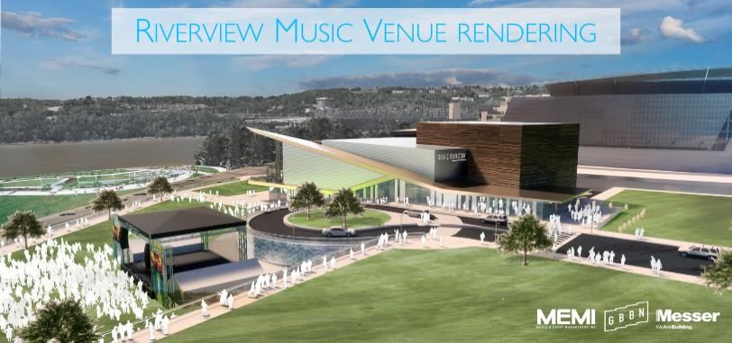
In 1925, the Official Plan of the City of Cincinnati sought to guide physical growth and development; in
response to the advent of the automobile, this plan focused heavily on transportation.

Central Riverfront Urban Design Master Plan (2000)
Beginning in 1996, Urban Design Associates worked to produce the Central Riverfront Urban Design
Master Plan for Cincinnati and Hamilton County. As part of the process, the city and county appointed a
commission to “recommend mixed usage for the riverfront.” The result of that effort
was The Banks, which contained recommendations on land use, parking, finance, phasing, and
developer selection for the central riverfront. The master plan ultimately incorporated this vision and
led to the Banks Partnership and Planned Development District described below. These subsequent
efforts produced updated master plans, referenced below.

Plan Cincinnati (2012)
Like many other American cities, Cincinnati experienced disinvestment and post-war flight from the
center city and saw its population decline until 2011, when a slight uptick began. In 2012, the City
Council adopted Plan Cincinnati, its first comprehensive plan in over 30 years. With a vision for “Thriving
Re-Urbanization,” the plan laid out its goals, strategies, and actions based on cautious optimism for
future growth. Four geographic principles guide the location of future investment and growth: 1) Focus
revitalization on existing centers of activity; 2) Link centers of activity with effective transportation for
maximum accessibility; 3) Create new centers of activity where appropriate; and 4) Maximize industrial
reinvestment in existing industrial areas. Plan Cincinnati is available online as well as among the files on
the 2019 ULI Hines Student Competition Resources available in Dropbox.

2040 OKI Regional Transportation Plan (2016)
Another important source of regional strategy and planning affecting Cincinnati is the Ohio-Kentucky-
Indiana (OKI) Regional Council of Governments. OKI serves as Greater Cincinnati’s metropolitan planning
organization with authority over federal monies for regional surface transportation. In 2016, OKI
adopted the 2040 OKI Regional Transportation Plan, which seeks to encourage walkable, higher-density
development in growing and infill areas that will support more transit options. Notable OKI
recommended plans near the competition area include projects to replace the Brent Spence Bridge (I-
71/I-75) to the west of downtown, extend the Ohio River Trail west from Smale Riverfront Park to Mill
Creek and east from the Reds Stadium, and extend the Cincinnati streetcar to Newport, Kentucky. See
more at the 2040 Long-Range Plan Projects Viewer.

Green Cincinnati Plan (2018)
The Green Cincinnati Plan outlines goals of 100 percent renewable energy for the city by 2035, and an
80 percent reduction in carbon emissions by 2050. It anticipates coming trends such as electric vehicles
(by adding charging infrastructure) and autonomous vehicles (by considering how to repurpose land
previously dedicated to parking), among others. In part because of plans like this one, in 2018, Site
Selection named Greater Cincinnati the number-one metro area in the United States for sustainability.

                                                                                                     10 of 34
Urban Growth and Development Downtown
Between 2012 and 2016, downtown Cincinnati enjoyed roughly $1.5 billion in investment activity.
Downtown added 50 new businesses in 2017 and saw $503 million of investment in projects completed
that year, with an additional $567 million under construction. The CBD office market boasts a strong
average asking rent of $18.02 per square foot and witnessed over 38,533 square feet of positive net
absorption in Q3 2018, with vacancy at 15.1 percent. Cincinnati saw 2,046 residential units supplied over
the 12 months through the end of Q2 2018 and residential occupancy in the city is around 95 percent.3
Retail downtown grew by 5 percent with 665 businesses in 2017, 50 percent of them dining. The
Cincinnati region hosted a record 26.6 million visitors in 2017, up 2 percent from 2016. Since 2014, five
hotels have opened within the CBD, and nine more are in early development stages. More than 2,500
new hotel rooms are possible in Cincinnati within the next three years.
Major Area Redevelopment
Soccer Stadium
In May 2018, Major League Soccer awarded Cincinnati an expansion franchise, FC Cincinnati (FCC). A
$200 million to $250 million soccer stadium broke ground in the West End in 2018 and is scheduled to
open in 2021.
Union Terminal
The art deco train station completed a $228 million restoration in November 2018. A 0.25 percent sales
tax primarily funded the project in the Queensgate neighborhood. Amtrak’s Cardinal line between New
York and Chicago serves this National Historic Landmark, which houses the Cincinnati Museum Center.
Music Hall
Also a historic landmark, this 256,500-square-foot venue in Over-the-Rhine, originally built in 1878,
underwent a $135 million renovation and reopened in late 2017. The building is home to the Cincinnati
Symphony Orchestra, Pops Orchestra, Opera, Ballet, and May Festival.
Figure 4. Renovated Cincinnati Music Hall, 2017. (Larsonj3 via Wikimedia)
3
Knowledge Report, Multifamily Research & Forecast Report 1H 2018, Colliers International.
11 of 34The Competition Challenge
The Competition Challenge reflects reality; however, we have changed certain details in this brief for the
purposes of the competition. DO NOT CONTACT the real-world owners or representatives of the
parcels or any of the public, private, or nonprofit organizations involved.
Mt. Adams
West End
Queensgate
Covington, Newport,
Kentucky Kentucky
Figure 5. The competition site context/influence area. (ULI)
Fort Washington Way
Fort Washington Way (FWW) is an approximately one-mile stretch of sunken highway that cuts through
the heart of Cincinnati, creating a substantial disconnect between the riverfront and the CBD. FWW
hosts both I-71 and US-50. Interstate 71, which runs northeast to southwest, links Louisville, Kentucky,
to Cleveland, Ohio, and connects travelers to other critical east–west interstates such as I-70, I-80, and I-
90. U.S. Route 50, part of the original U.S. Numbered Highway System, stretches across the country from
Maryland to California. Construction commenced on FWW in the mid-1950s and extended over nine city
blocks. FWW opened in 1961 and had exceeded its designed capacity by the late 1990s. A snarl of on-
ramps and off-ramps increased collisions and endangered public safety.
12 of 34Figure 6. Fort Washington Way through the years. (The Banks)
Fort Washington Way 2000 and Decking Proposals
The Fort Washington Way 2000 project redesigned and rebuilt the highway, reducing the overall right-
of-way and restoring Second Street in the process. Reconstruction included structural pilings along the
median and foundations that could support an elevated surface and decking over the highway. Since
this time, the vision of extending downtown to the riverfront has grown. A report by Parsons
Brinckerhoff in 2002 indicated that the pilings were placed such that decks might extend from mid-block
Elm to Race on the west to mid-block Walnut to Main on the east, and that the design of the deck will
support a commercial office building up to four stories high, as well as green space. Additional capacity
and development are possible with additional foundational support. This report also provided decking
configurations, plus cost estimates relevant at that time. The city of Cincinnati has retained the air rights
to FWW since its reconstruction.
13 of 34The Central Riverfront and the Banks
Across Fort Washington Way to the south, the central riverfront has been a destination in progress since
the late 1990s. Since 1998, Hamilton County and the city of Cincinnati have invested approximately $1.8
billion in redevelopment in this area, including the realignment of Fort Washington Way. These public
entities, together with the original Master Developer Riverbanks Renaissance LLC, composed of Carter
Real Estate/The Dawson Company, formed a public/private partnership with the ultimate vision of $2.7
billion invested in further transforming around 195 acres into a transit-oriented, mixed-use, vibrant, and
sustainable gateway to southern Ohio. The Banks Planned Development District broke ground in 2008,
with the goal of developing a 24-hour neighborhood—not an insignificant challenge for an area flanked
by two large stadiums whose regular use accounts for only about 90 days per year, and an arena that
accounts for approximately 100 events per year. Information about the Banks district is available online,
as is information about the Banks Public Partnership.
Figure 7. The original Banks Master Plan from 2007. (The Banks)
14 of 34Your Challenge
As development interest continues to grow in and around downtown Cincinnati, the city, the county,
and key stakeholders and landowners have come together as a group with the broad vision of finally
connecting downtown and the riverfront. Under the competition scenario, this group, the Cincinnati
Fort Washington Way Development Partnership (the Partnership), has selected your team as master
developer to provide a specific vision and growth plans to create a comprehensive environment for the
competition site that is programmed, designed, built, and operated with all the elements necessary to
promote a vibrant, transit- and pedestrian-oriented, sustainable, and mixed‐use neighborhood.
The Partnership is enthusiastic about redeveloping the area in a way that creates value for individual
property owners, city residents, and the broader region. This transition area should consider its context
and contribute to the future growth and reputation of the city and county.
As master developer, your team has entered into an agreement to evaluate the benefits and financial
possibilities of combining certain parcels to redevelop or sell as one comprehensive development site.
These parcels comprise the entirety of blocks A through G, outlined in figure 8. To develop above Fort
Washington Way, you must acquire the air rights for Block A from the city of Cincinnati. To develop
blocks B through G, you must acquire air rights from the city and county. You may consider alternative
structures to upfront payments for air rights. In total, these combined parcels contain about 12.9
developable acres, not including public rights‐of‐way.
You must evaluate the feasibility of adding one or more parcels along Third Street to the site in order to
restore the urban fabric in this part of town. Such blocks are privately owned, so you must factor
acquisition costs into your proposal. Whether or not you choose to develop these optional parcels, your
team must assess the potential of integrating improvements to the public realm along Third Street into
your proposal.
You may wish to include in your proposal broader recommendations that extend your vision beyond the
competition blocks.
You will need to win the buy-in of the steering committee that represents the Partnership. The steering
committee is charged with implementing policies and making recommendations to the Partnership
entities. Your specific vision and proposal, in its placement of land uses and discussion of building siting
and design, should support the Partnership’s broad vision for reconnecting downtown and the
riverfront, as well as the general nature of the area as vibrant, transit- and pedestrian-oriented,
sustainable, and mixed‐use. Your proposal should integrate with existing land uses and enhance their
assets to create more value. Your proposal should outline the suitability of the new development you
propose, and what flexibility, if any, your proposal might have should further public engagement occur.
15 of 34Figure 8. Primary competition area: blocks A–G.
Additional Context
Economic Development Stakeholders
City of Cincinnati and Hamilton County
The city and county are the primary stakeholders in the Partnership. Together, they have advanced
more than $2 billion in transportation, transit, stadiums, museums, mixed-use development, and other
improvements in the riverfront since 1998.
The Cincinnati Reds and the Cincinnati Bengals
Both professional sports teams are active participants and stakeholders in driving major activities for the
redeveloped riverfront.
The Port—an Ohio Port Authority
Established in 2000, the Port of the Greater Cincinnati Development Authority is an economic
development agency focused on revitalization and public financing throughout Hamilton County.
16 of 343CDC and DCI
Downtown Cincinnati Inc. (DCI) is a nonprofit business organization with a mission to build a dynamic
metropolitan center valued as the heart of the region. The organization has been funded by a special
improvement district that includes all property within the boundaries of Eggleston Avenue on the east,
Central Parkway on the north, Central Avenue on the west (including the Centennial buildings), and the
river on the south (excluding the two stadiums). DCI recently became a subsidiary of the Cincinnati
Center City Development Corp. (3CDC), an organization that has put significant investment into Over-
the-Rhine neighborhood since 2004.
Architecture
Cincinnati boasts a wide variety of architectural styles
spanning the 19th and 20th centuries. Examples
scattered throughout downtown and adjacent
neighborhoods include Greek revival, Gothic revival,
Italianate, and Queen Anne styles, as well as newer
styles, such as the César Pelli–designed Aronoff
Center. Some significant Cincinnati buildings, such as
the Art Deco Union Terminal, are not near the site,
while others contribute to the significance of the
Cincinnati skyline near FWW. Among the notable
high-rise buildings adjacent to or near FWW are the
Carew Tower, a French art deco building at 441 Vine
Figure 9. Fourth Street east from Race in Cincinnati, circa Street; the “PNC Tower” at Fourth and Vine streets;
1910. (Shorpy)
the Scripps Center at 312 Walnut Street; and the
Great American Tower at 301 East Fourth Street.
Adjacent Communities
Five neighborhoods are immediately adjacent to downtown: Queensgate, West End, Over-the-Rhine,
Pendleton, and Mount Adams. Queensgate, west of downtown, has a small residential population and
largely industrial and commercial land uses. West End, northwest of downtown, has a challenging
history of urban renewal and now consists of varied and distinct sub-neighborhoods. With construction
of the soccer stadium, the neighborhood hopes to see community benefits accrue locally. Over-the-
Rhine is Cincinnati’s largest historic neighborhood and home to the Music Hall and Findlay Market. The
360-acre neighborhood comprises one of the largest, most intact, 19th-century urban historic districts in
the United States and likely hosts America’s largest contiguous collection of 19th-century Italianate
architecture. More than $500 million of investment in Over-the-Rhine has revitalized Washington Park
and Ziegler Park as well as a number of buildings, and brought an economic resurgence to the area,
albeit with concerns of displacement. Pendleton is one of the city’s smallest neighborhoods and falls
within the Over-the-Rhine historic district. Mount Adams is a largely residential neighborhood perched
atop one of Cincinnati’s hillsides, to the east of downtown.
17 of 34Central Riverfront Garage
The Banks includes a multilevel parking garage facility and development podium that lifts the
development area out of the floodplain and provides structural support for all development that was set
forth in the master plan. The Banks’ goal for the facility upon completion was 8,500 public parking
spaces, approximately 75 percent of them structural, across eight city blocks. Phases I, II, and IIIA (see
the Banks Master Plan) are complete. Owned by Hamilton County and operated by SP+, the structured
garage facility currently spans five city blocks between Race Street to the west and Broadway Street to
the east and accounts for approximately 4,800 total parking spaces. The master plan intended for all
surface lots within the Banks development to be converted to structured parking facilities to support
mixed-use development and/or green space.
Riverfront Transit Center
Figure 10. Riverfront Transit Center. (The Banks) Figure 11. Riverfront Transit Center. (SORTA)
With the reconstruction of FWW, planners saw a unique opportunity to build the Riverfront Transit
Center (RTC), a multimodal facility that runs 3,740 feet in length underneath Second Street. The goal
was for non-diesel buses and both intercity and intracity rail lines to pass through the RTC, but voters
denied the possibility of commuter rail via referendum in 2002. The RTC was under construction at that
point and opened in 2003. Today, the RTC is used primarily during concerts and baseball games, and
suffers some maintenance deficiencies, although revenue from parking and charter bus use cover its
operating costs. The hope is that a fully developed riverfront will provide the ridership to justify full use
of this transit resource to benefit the city and the region. The Riverfront Transit Center also
accommodates a major water main and the Riverfront Running Track (RRT), a rail right-of-way owned by
the city and discussed in the April 2013 Railroad Improvement and Safety Plan.
Streetcar
As in many other American cities, streetcars were a primary form of transit for Cincinnatians from the
mid–19th century to mid–20th century, with nearly 250 miles of track. Cincinnati brought back the
18 of 34streetcar with the grand opening of the Cincinnati Bell Connector in 2016. The streetcar travels a 3.6-
mile loop from Second Street at the Banks north to Over-the-Rhine, crossing FWW twice in the process.
Future of Transport
Cincy Red Bike debuted in 2014 and now hosts over 50 locations. In summer 2018, Bird and Lime
debuted electric scooters in the city, and Cincinnati, like many cities, is grappling with how to manage
this growing form of transportation. In spring 2018, the Ohio governor signed an executive order
authorizing autonomous vehicle testing in the state.
Flooding
The competition area is not only adjacent to the Ohio River, but its presence has been a defining historic
element for the riverfront. Cincinnati has experienced 105 floods since 1858. One of the worst floods
occurred in 1937, when the Ohio River reached 80 feet. Floods continue to threaten development along
its banks; flooding in February 2018 saw the river surpass 55 feet and inundate parts of the Smale
Riverfront Park. The reconstruction of FWW included a 30-foot-tall flood wall and pumping station to
protect the highway trench from floodwaters.4 As described above, the Banks parking garage facility
enables development within the floodplain.
The National Underground Railroad Freedom Center
As a national interpretive and educational center, the National Underground Railroad Freedom Center
serves as a vehicle to relate the lessons of the Underground Railroad Movement to contemporary
freedom movements. Completed in 2004, the Freedom Center hosts 100,000 local, regional, and
national visitors per year. Located in the center of the Banks development at the northern terminus of
the Roebling Suspension Bridge, it provides an important visual focal point. The Freedom Center consists
of 158,000 square feet across three five-story pavilions and represents a private and public investment
of approximately $110 million. The Port Authority issued financing in the amount of $50 million in tax-
exempt bonds for the construction of the museum. The Freedom Center interfaces with the Riverfront
Transit Center to the north and the Smale Riverfront Park to the south.
The Central Riverfront: Paul Brown Stadium
Paul Brown Stadium opened in 2000 and is the home of the Cincinnati Bengals football franchise. The
stadium seats around 66,800 fans and, in 2018, hosted 10 Bengals homes games from August to
December. The Bengals lease approximately 40 acres from Hamilton County—22 acres for the stadium,
plus a practice field to the west and parking to the south. The Bengals have an interest in maintaining
areas where Bengals fans can tailgate and protecting views to and from the stadium. Total attendance is
approximately 450,000 per year. In November 2018, the county agreed to purchase a 15-acre site
southwest of Paul Brown Stadium, currently used as a concrete plant and aggregate distribution yard,
for the development of additional surface parking for the Bengals and the potential development of a
Bengals practice facility. The Bengals’ lease, through 2026, allows the team to review proposed
4
"Reconstructed Highway Revives Cincinnati Riverfront." Civil Engineering. Vol. 70, no. 10. American Society of
Civil Engineers. October 2000. p. 14. ISSN 0885-7024.
19 of 34development, which includes remaining developable parcels in the Banks. For the purposes of this
competition, consider how you will achieve buy-in from this stakeholder for blocks B through G.
The Central Riverfront: Great American Ball Park
The Great American Ball Park has been the home of the Cincinnati Reds—baseball’s first professional
franchise—since the 2003 season. Situated on approximately 29 acres, the stadium seats around 42,300
fans. In 2018, the Reds hosted around 80 home games from March through September. The Reds also
lease the Great American Ball Park from Hamilton County. Total fan attendance is approximately 1.8
million to 2 million per year.
Music Venue and Event Lawn
In June 2018, the city and county selected the Cincinnati Symphony Orchestra (CSO) and Music and
Event Management Inc. (MEMI) to develop an indoor/outdoor music venue. In November 2018, the
Bengals agreed to the development of the venue on lots 27, 28, and 23, immediately adjacent to the
east side of the stadium. The developers anticipate that the venue will open in 2020 and draw more
than 300,000 patrons per year.
Figure 13. Music venue rendering 1. (MEMI, GBBN, Figure 12. Music venue rendering 2. (MEMI, GBBN, Messer)
Messer)
General Electric U.S. Global Operations Center
In June 2014, the General Electric Company selected the Banks for its only U.S. Global Operations
Center. The GE Global Operations Center is a 338,000-square-foot, 12-story office tower that is home to
over 2,000 professionals. The office building extends the width of a full city block, occupying land from
Second Street to West Freedom Way, with Rosa Parks Street to the east.
The Central Riverfront: U.S. Bank Arena
East of the Great American Ball Park is the 40-year-old U.S. Bank Arena for hosting sporting and
entertainment events. The aging venue seats more than 17,000 but is not big or new enough to attract a
major sports franchise. The arena owner has proposed a sales tax to rebuild a venue on the site, but the
county has not agreed to the sales tax increase. The arena draws about 600,000 patrons per year.
20 of 34To the South: Smale Riverfront Park, the Roebling Bridge, and the Ohio River
Adjacent to the southern edge of the main competition site, public and private funds have helped build
the 40-acre Smale Riverfront Park, which broke ground in 2008. The Cincinnati Park Board manages this
open space. The Schmidlapp Event Lawn provides a green roof for the parking garage. The upper level of
the park is above the 100-year flood, while the lower level is within the floodplain.
Development along Third Street, North of Fort
Washington Way
Moving from west to east, a series of parking
garages and surface parking lots define the
pedestrian experience on Third Street adjacent
to FWW. The Central Riverfront Urban Design
Master Plan adopted by the city in 2000, as
amended, anticipated major office development
along Third Street. Several infill or
underdeveloped sites remain along Third Street.
Figure 14. Central Riverfront Urban Design Master Plan. (City of
Cincinnati)
City Club Cincinnati
One bright spot encouraging pedestrians to linger along Third Street is the recently completed $67
million City Club Apartments project, which opened at 309 Vine Street in spring 2018. The development
includes 45,000 square feet of class A creative office space, 294 luxury apartments, plus restaurants and
retail. The owners of this building are now planning a new mixed-use development in the Fourth and
Vine Tower, often called the PNC Tower and originally designed by architect Cass Gilbert. City Club
Apartments LLC wants to renovate the 31-story, 340,000-square-foot building into a residential and
commercial complex for approximately 400 residents in 262 apartment units.
Historic Districts
The city has both national and local historic districts within its boundaries. Just north of the site are
three districts listed on the National Register of Historic Places, including two with buildings
(highlighted) adjacent to Third Street:
• West Fourth Street Historic District5
• East Fourth Street Historic District6
• Main and Third Street Cluster7
5
Reference #76001443.
6
Reference #88000078.
7
Reference #83001984.
21 of 34Additional Area Development
• Seventh and Elm. Shillito’s West is an approximately 400,000-square-foot city-owned commercial
building. Neyer Properties has a development agreement with the city for Neyer to explore
redevelopment of the property into a mixed-use project consisting of approximately 100,000 square
feet of office space, 16,000 square feet of street-level retail, and a 450-space public parking garage
at an estimated cost around $28 million.
• Fourth and Race. With this redevelopment, 3CDC will construct and operate the five-level, 574-
space garage and add 23,000 square feet of street-level retail at a cost of $44 million. Another
developer, Flaherty and Collins, will build an eight-story, 264-unit apartment building above the new
garage at an estimated cost of $73.5 million. The total estimated construction cost is $117 million.
• Seventh and Race. Vision Hospitality wants to transform a building at 37 West Seventh Street into a
94-room boutique hotel with a coffee bar and restaurant.
• Seventh and Vine. Pearl Capital Management will renovate the Provident office building into 160
market-rate residential apartments and ground-floor commercial space at a cost of around $38
million.
• Court and Walnut. This 18-story mixed-use development will include a 45,000-square-foot, two-
story Kroger grocery store. Above the store will be a 560-space parking garage and 139 residential
apartments. The project is expected to cost around $90 million and be complete in September 2019.
• Fourth and Walnut. As part of a job expansion project, U.S. Bank intends to renovate its existing
office space in the CBD at a cost of $9 million. The project aims to retain approximately
$160,683,000 in annual payroll in their current locations and add 400 new jobs.
• Sixth between Main and Walnut. Neyer Holdings will renovate an existing office building with
ground-floor retail at 126–128 East Sixth Street into a mixed-use apartment building, with 45
market-rate residential one-bedroom units and new commercial space at ground level. The total
project cost is estimated at $12 million. Neyer Holdings also plans to renovate an existing office
building at 130–132 East Sixth Street with ground-floor retail into a LEED-certified building, with
13,211 square feet of renovated office space and all new commercial space on the ground floor. The
total project cost is estimated at $4.5 million.
• Third and Main. A developer is planning to combine three historic buildings in the Main and Third
Street Cluster into a 105-room hotel and bar.
• Sixth and Sycamore. Sun Development wants to redevelop 299 East Sixth Street, a 130-room
Cambria Suites next to the Proctor & Gamble headquarters.
• Ninth and Broadway. Rookwood Properties received a 12-year tax exemption for 100 percent of the
value of improvements to develop the six-story Crane Factory Flats at 824 Broadway. The Flats
opened in December 2018 after a $12 million renovation. It includes 69 units and 63 new parking
spaces.
22 of 34Detailed Assignment
• Your proposal should serve as a catalyst for further redevelopment in the area, including adjacent
neighborhoods, enhancing the value of any potential original investment.
• The Partnership has asked you as master developer to assist in ascertaining the following:
o The current worth of the combined parcels in the primary competition area for a potential
investment.
o A land acquisition plan.
o The type of redevelopment the market would support.
o An implementation plan that outlines strategic partnerships and community engagement.
o The worth of the total redeveloped site at the end of a 10-year period.
o The subsidies (if any) that would make redevelopment feasible and the sources of those
subsidies.
o If sold at the end of Year 10, the return the entire project would provide to the Partnership
as owner (both leveraged and unleveraged before-tax internal rates of return).
In order to meet the Partnership’s needs, your team must meet the following requirements and address
these goals:
• Understand the social, historical, demographic, political, and economic forces in the Cincinnati
region and analyze the study area, including bordering neighborhoods, in relation to the smaller
development in the competition site. This analysis must consider the context of the competition
site’s relationship to the surrounding neighborhoods as well as study land use, circulation,
infrastructure, demographics, and site forces, among other factors.
• Propose a master land use plan for the study area that includes but is not limited to land and
building uses, blocks, streets, transit lines, and connectivity.
• Propose an urban design schedule for the competition site that addresses overall design
characteristics, as well as building typology, architecture, and sustainability.
• Propose a market-feasible development program and financial pro forma for the development site
that accounts for phasing as well as a 10-year hold. This development program must address overall
competition-challenge questions and objectives and, more specifically, provide market-driven
assumptions and feasible sources of financing and, if applicable, subsidies.
• Identify all phasing within the development site and detail a concept design for all development
components within the 10-year hold period. The details should include, but not be limited to,
building footprints, streetscapes, elevations, sections, and renderings showing the intended
characteristics of your development proposal. You only need to depict details for what gets built
over the course of the 10-year phase.
23 of 34Assumptions
To address the needs of your client and create a feasible and compelling plan, your team must adhere to
the following assumptions:
• Zoning. For this competition, use the Cincinnati Zoning Code effective as of 2004, which is Title XIV
of the Municipal Code. Do not use the Draft Land Development Code. The site falls within the
Downtown Development District (DD) zone and a Planned Development District (PD-43).
o You may use DD zoning for decking Fort Washington Way, or propose alternate zoning.
o Assume blocks B through G are not part of a Planned Development District and use DD or
propose alternate zoning. You do not need to consider the final development plan for PD-
43, which is not available online.
o If your team proposes to change existing zoning, clearly state your rezoning proposal, and
address the potential ramifications of any zoning changes. As one example, if you propose
to exceed height limits, explain how you will obtain stakeholder buy-in, given that many
existing buildings may wish to maintain views to the river.
o The City of Cincinnati Zoning Administration website provides links to the Zoning Code and
to the Zoning Map, via the Cincinnati Area Geographic Information System (CAGIS).
o Relevant Fort Washington Way parcel IDs and descriptions in CAGIS:
▪ Block A:
• 008300080003
• 008300080004
• 008300090001
• 008300090002
▪ Adjacent city-owned parcels outside of Block A include:
• 008300080002
• 008300090003
• 008300080006
• 008300090004
o DD overlay maps begin at the end of the Chapter 1411 of the code, including:
▪ Map 1411-05 Use Subdistrict Overlay
▪ Map 1411-09 Floor Area Ratio (FAR) Overlay
▪ Map 1411-13 Maximum Building Height Overlay
▪ Map 1411-15 Zero-Setback Overlay
▪ Map 1411-17 Commercial Continuity Overlay
▪ Map 1411-19 Skywalk Overlay
▪ Map 1411-23 Parking Subdistrict Overlay. City Council recently approved a plan to
eliminate parking minimums downtown. The Proposed Parking Overlay District is
available for download from OrgSync in the “Files” section.
• Decking. Sources such as Parsons Brinckerhoff have indicated that the infrastructure in place
now will support four levels of building on decks over Fort Washington Way. Use these
suggested configurations and structural limits as general guidance. If you make substantive
24 of 34changes—for example, to support additional building levels—you must incorporate the costs
into your proposal and justify them.
• Redevelopment tools. The state, county, and city offer multiple tools to encourage
redevelopment.
o CRA. The Community Reinvestment Area tax abatement program is an economic
development tool administered by the city of Cincinnati that provides real property tax
exemptions for property owners who renovate existing buildings or construct new
buildings. This program offers a property tax exemption on the improvement value of a
project for up to 15 years. Projects that earn certain certifications, such as Leadership in
Energy and Environmental Design (LEED) Silver or higher, automatically qualify for a
maximum 100 percent (net 60 percent) CRA tax abatement on the improvement value
for 15 years (100 percent – 25 percent CPS PILOT – 15 percent VTICA Contribution = Net
60 percent). The Voluntary Tax Incentive Contribution Agreement (VTICA) is a payment
in lieu of taxes (PILOT) program with a third-party nonprofit designated by the city,
where you contribute a portion of the abated taxes (up to 15 percent of the abatement)
to support neighborhood-based services. For the site area, VTICA PILOT would go to
fund the operations of the Cincinnati Bell Connector. More information is available at
the link above and by reviewing the CRA application document.
o District TIF. Developers making a large-scale investment that requires substantial public
improvements may be able to use tax increment financing (TIF) to offset a portion of
those costs. In the case of district TIFs, amounts derived from the increased assessed
value of any improvement to real property are directed to finance the construction of
public infrastructure. The city has 21 tax increment financing districts. The competition
site falls within the 275-acre TIF district 2, “Downtown South/Riverfront.”
o Project TIF. A private project TIF is a tax increment financing structure placed on a single
project. If a project qualifies under a gap analysis, the tax increment from improvements
can be used more broadly. The increment can be rebated back to the developer
functioning as a tax abatement that could go up to 30 years. Also, a developer can use
the increment to cover debt service for the project if it serves an urban redevelopment
purpose, or to finance public improvements that directly benefit the project site.
o PACE. The Greater Cincinnati Energy Alliance facilitates Property Assessed Clean Energy
(PACE) financing in Ohio and Kentucky. PACE encourages energy efficiency and
renewable energy on commercial properties, with long-term financing requiring no
down payment. Borrowers repay the investment via a special assessment on their
property tax bill over a period of up to 30 years.
• Existing uses. For the purposes of the competition, when your team contemplates land
acquisition and assembly scenarios, the current tenants’ leases expire at the end of December
2019, with the option to renew on a month-to-month basis. You may find it optimal to retain all,
some, or none of the tenants, and you may change lease rates as you deem appropriate when
you sign a new lease or bring on a new tenant. If new lease rates are applied, they should reflect
market rates.
25 of 34• Open space and natural systems. In your proposal, you need to indicate any proposed open
spaces and their relationship to the overall strategy and financial vision, as well as any
landscaping/environmental strategies your proposal introduces.
• Affordable/workforce housing. For the purpose of the competition, a minimum of 10 percent of
new residential product, both for-sale and rental, must be units affordable for low- to
moderate-income households. The units should have two or more bedrooms and be dispersed
throughout the project. These requirements apply to every phase of development.
• Complete neighborhoods. Give priority to mixed-use and mixed-income development. Any
development that fails to address these concepts will not achieve formal entitlement approval
or stakeholder buy-in. The city and county want to ensure that any development they engage in
will help the city, region, and surrounding neighborhoods meet their objectives.
• Rights-of-way and circulation patterns. You may choose to close or create public streets within
your development blocks. If you close a public right-of-way and develop the space, you need to
buy the land from the city at fair market value. You may also change circulation patterns.
o Southwest Ohio Regional Transit Authority (SORTA):
▪ Downtown Cincinnati Map
▪ Regional System Map
• Construction costs. You may use the cost tables generated by RSMeans or a resource of
equivalent quality as a guideline to estimate your construction costs. RSMeans Online offers 30-
day free trials. Assume you are using union labor and be sure to get specific estimates for Ohio.
• Utilities. You may relocate all local distribution lines for power, gas, water, and communications
at the developer’s expense, based on utility-company standard pricing. You may not move
stormwater or sewer infrastructure. You must include a plan to address on-site stormwater.
• Real property taxes. For the purposes of the competition, use 96.515579 as the millage rate.
Alternatively, teams may use parcel-specific rates available online at the Hamilton County
Auditor Online Property Access website.
• Inflation rate. For the purpose of the competition, teams may consider that all costs are subject
to an inflation rate compounded at 2 percent per year.
• Market-feasible costs and pricing. Although the competition uses a fictional scenario, your
team needs to meet the expectations of the Partnership and come up with a financially feasible
plan for the site. Unless you are given a cost or an assumption, you need to come up with a
market-appropriate amount that you can justify in your pro forma (e.g., current sales price for
land in the area, market rents for various uses, project costs, etc.). If you find that your
development program requires a subsidy, the subsidy amount should be realistic and from a
viable source.
• Demolition and remediation costs. Demolition and remediation costs vary greatly depending on
the typology and former land use of the different parcels. For the purposes of this competition,
teams can apply a general cost per square foot to demolish and remediate parcels. For example,
for the purposes of this competition, it can cost the same to demolish a surface parking lot as to
demolish a two-story building that covers the same area. Alternatively, teams can assign costs
based on an assessment of existing structures and land uses for a more accurate calculation.
26 of 34You can also read