BROOKFIELDS AND BURNSIDE, ROMSEY TOWN, CAMBRIDGE - The Development of Two Streets - Capturing Cambridge
←
→
Page content transcription
If your browser does not render page correctly, please read the page content below
MILL ROAD HISTORY SOCIETY
BUILDING AND SITE REPORT NO. 19

 BROOKFIELDS AND BURNSIDE,
       ROMSEY TOWN, CAMBRIDGE
       The Development of Two Streets

                            John McGill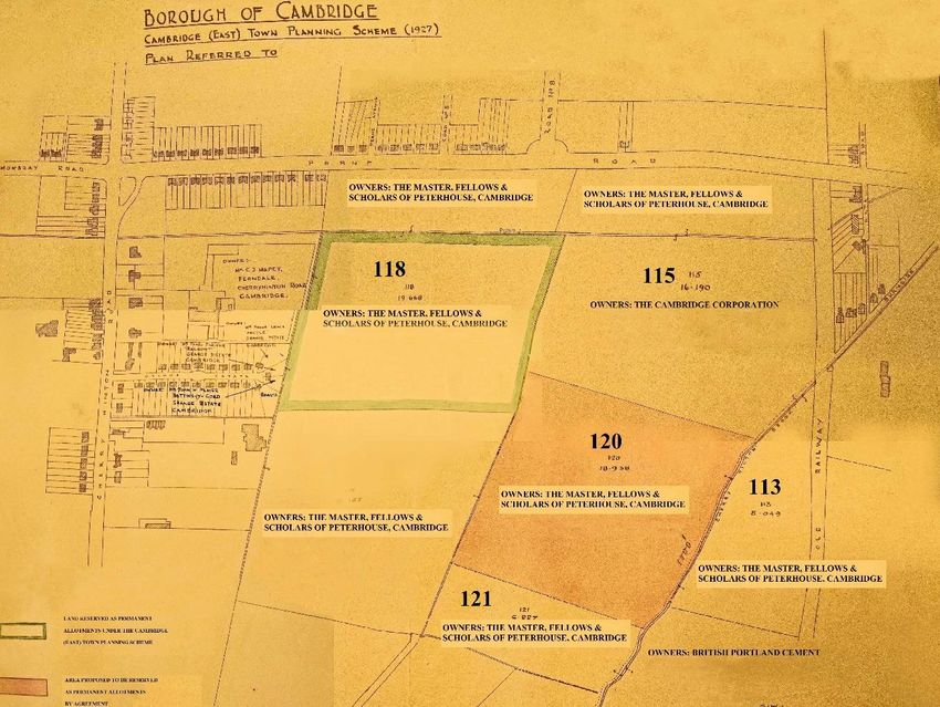
MILL ROAD HISTORY SOCIETY BUILDING/SITE REPORT                   BROOKFIELDS AND BURNSIDE

              The Mill Road History Society was formed in 2015 to continue
              the work of the HLF-funded Mill Road History Project (2013‒
              2015). One of the Project’s principal products was a series of
              twelve building or site reports, researched and produced by vol-
              unteers. These were published in print form for limited deposit,
              and on the website www.capturingcambridge.org. The Society
              has maintained this important facet of the Project’s work, and
              the present report is the nineteenth in the series.

                                 First edition ‒ May 2021
                                  Author : John McGill

Cover image: Burnside and bridge from the north (photo: John McGill, 2020)

                                             2
MILL ROAD HISTORY SOCIETY BUILDING/SITE REPORT                                BROOKFIELDS AND BURNSIDE

           Mill Road History Society Building and Site Reports
1. 44a Mill Road Ian Bent and Kieran Perkins (2014; 3rd edn 2015)
2. East Romsey Town Cement Works John McGill (2015)
Pre-industrial ‒ Cement Production ‒ Post-industrial ‒ Search for New Uses
3. Mill Road Windmill Allan Brigham, Gordon Clark and Peter Filby (2015)
Post Mill ‒ Brick Tower Mill ‒ Residential and Commercial Properties
4. 85‒89 Mill Road Simon Middleton and Allan Brigham (2015)
Sturton Town Hall ‒ Empire ‒ Kinema ‒ Scholars House
5. 124‒134 Mill Road (‛Railway Cottages’) Caroline Wilson (2015; 3rd edn 2016)
Accommodation for Railway Workers ‒ Temporary Housing ‒ CHS Group Flats and Hostel
6. 186 Mill Road Katie Blyth (2015; 2nd edn Sept 2015)
Bootmaker and Undertaker ‒ Watchmaker ‒ Charity Shop ‒ Cycle Shop
7. Mill Road, Cambridge: 1823‒1851 Allan Brigham (2015; 2nd edn Sept 2015)
The Early Development of Mill Road — A Narrative from the Newspapers

8. 206 Mill Road Katie Blyth (2015; 2nd edn Sept 2015)
Private Dwelling ‒ Pharmacy ‒ Antique Shop
9. 81a Mill Road, Part I Ian Bent and Allan Brigham (2015)
Cambridge Union Workhouse ‒ Cambridge County Infirmary
10. Bath House, Gwydir Street Julia Ewans (2015)
Gwydir House ‒ Public Baths — Neighbourhood Centre
11. 175 Mill Road Katie Blyth (2016)
Corn Merchant ‒ Brewer and Beer Seller ‒ Fruiterer and other Retailing
12. Romsey Town Labour Club William Ingram (2015; 2nd edn Sept 2015)
13. Donkey’s Common and Adjacent Land Allan Brigham and James Ingram (2017)
Town Gaol ‒ Queen Anne Terrace ‒ YMCA ‒ Kelsey Kerridge ‒ ATS Huts ‒ Parkside
Swimming Pool
14. 299‒349 Mill Road, Romsey Town John McGill (2018)
Development of the ‛Magnet’ and ‛Holland Motors’ Sites
15. Mill Road Bridge Caroline Wilson (2018)
16. 186 Gwydir Street Sheila Cane (2019)
Home of the Parr and Palmer Families ‒ The David Parr House
17. The Mill Road Depot Allan Brigham (2019)
Wharf ‒ Eagle Foundry ‒ Workhouse ‛Industrial Training Ground’ ‒ Allotments ‒
Corporation Storeyard ‒ City Council Depot
18. Madras Road, Romsey Town, Cambridge John McGill (2020)
19. Brookfields and Burnside, Romsey Town, Cambridge John McGill (2021)

Also published by the Mill Road Society:
A Guide to Researching and Writing a Building or Site Report for the Mill Road Area
Ian Bent, Katie Blyth and Allan Brigham (2017)
[includes ‛Glossary of Useful Architectural and Building Terms for local historians
working in the Mill Road Area’].

                                                        3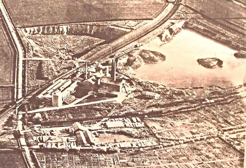
MILL ROAD HISTORY SOCIETY BUILDING/SITE REPORT                    BROOKFIELDS AND BURNSIDE

                                  ABBREVIATIONS

        CA: Cambridgeshire Archives                        OS: Ordnance Survey

                                   __________________

                                          NOTE
The assistance of the Cambridgeshire Archives in making documents available for research is
greatly appreciated, especially as this was undertaken during quarantine (lesser intensity) of
2020.
The Archivist of Jesus College was also very helpful concerning documents related to the
development of the Jesus College estate.
Comment and suggestion by residents of Brookfields and Burnside is also greatly appreciated,
with particular thanks to Samuel Lagdon and Lucy Rhymer.

Location
Brookfields constitutes the easterly continuation of Mill Road, Cambridge, from its junction
with Montreal Road. Brookfields itself has been severed into a western and eastern section
by the intervening ring road (Perne and Brooks Road). This report concerns the eastern
section of Brookfields together with Burnside, which is its further continuation to the east.

National Grid reference (median)
TL 475575
547529, 257502
52.196020, 0.15707015
52° 11' 46' N 00° 09' 25' E

                                              4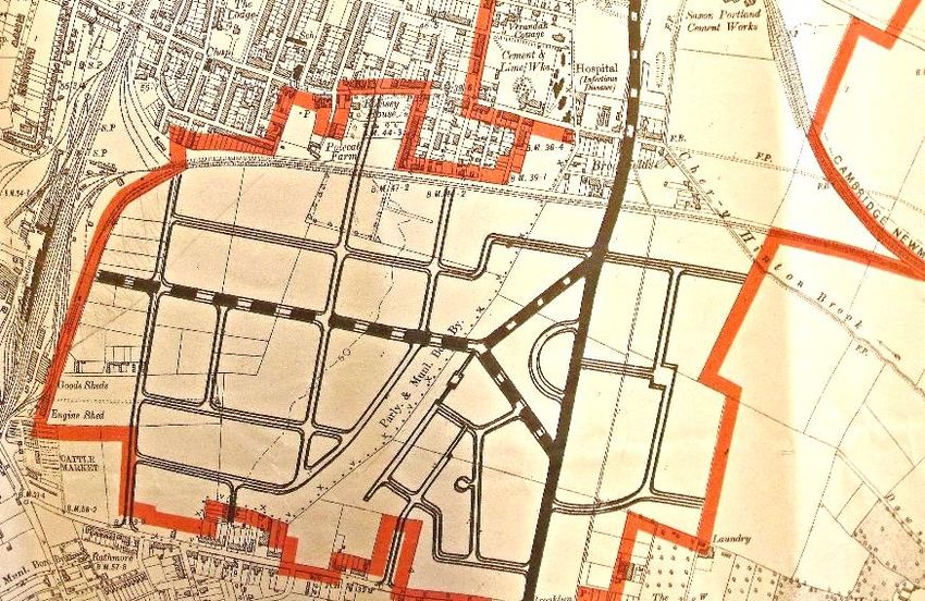
MILL ROAD HISTORY SOCIETY BUILDING/SITE REPORT           BROOKFIELDS AND BURNSIDE

                           TABLE OF CONTENTS

      INTRODUCTION                                                      6

      Overview of the Development of Brookfields and Burnside           7

      House Numbering                                                  14

             Brookfields                                               14

             Burnside                                                  16

      Design and Construction                                          17

      Utilities                                                        22

      The Development of Perne Road and the Cutting in Half

             of Brookfields                                            22

      Social and Economic Change and Valuation                         26

      The Houses                                                       28

      BIBLIOGRAPHY                                                     45

                              ________________________

                                           5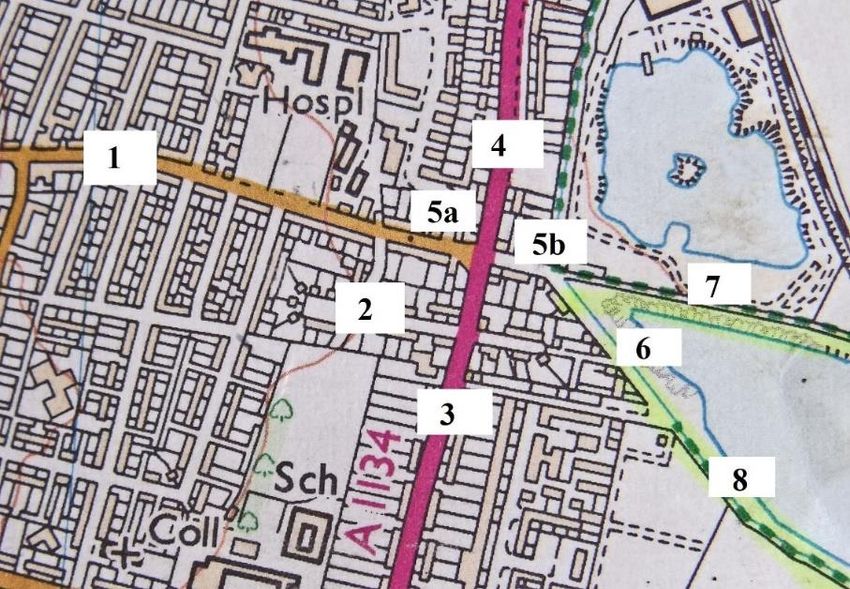
MILL ROAD HISTORY SOCIETY BUILDING/SITE REPORT                           BROOKFIELDS AND BURNSIDE

                                       INTRODUCTION
This report focuses on a small area of Romsey Town – a mere two streets, in fact – that lies just
beyond the far eastern end of Mill Road. There are stories to be told about any geographical spot,
and these two streets – Brookfields and Burnside – have their own particular history.

                   Figure 1 – General orientation, extract from OS map of 1999 (adapted)
                     1 = Mill Road; 2 = Montreal Road; 3 = Perne Road; 4 = Brooks Road;
                       5a = Brookfields (western part); 5b = Brookfields (eastern part);
                       6 = Burnside; 7 = The Tins (foot and cycle path); 8 = Snakey Path
                                             (foot and cycle path)

  Figure 1, above, shows the Brookfields/Burnside vicinity as it presently (2021) stands. At the
  centre left is the main junction where four streets meet; or is it three streets? Running to the
  south is Perne Road and to the north is Brooks Road – they have the same alignment and both
  act as parts of the Cambridge ring road. Brookfields runs both west and east (Perne
  Road/Brooks Road severing it into two sections, just as Perne Road severs Natal Road).
  This complexity stems from the imposing of a new road network on to an older one. Urban
  areas in particular are likely to represent a form of palimpsest – new development being
  placed over the old, with marks of the old still remaining, and an accommodation must be
  established. Renaming streets can cause some commotion and inconvenience, and here, in
  this part of Romsey Town, is an example of such a muddle. To complicate matters further,
  one of the streets – Burnside – has had its name changed, and the original system of house
  numbering has been considerably altered.
  Apart from exploring the history of the development of the streets, this report looks into why
  this muddle came about.
  Mill Road commences in the north west at Donkey Common and runs south east through
  Petersfield, over the railway, and through the centre of Romsey Town. Throughout its align-
  ment it acts as the spine of the district, with the residential roads running off it north and
  south. However, at its junction with Montreal Road (more or less across the road from
  Brookfields Hospital) the street ceases to be Mill Road and becomes Brookfields, which
  crosses Perne Road, continues for some distance and then, after a slight turn to the south,

                                                    6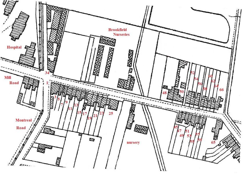
MILL ROAD HISTORY SOCIETY BUILDING/SITE REPORT                                         BROOKFIELDS AND BURNSIDE

becomes Burnside. The general alignment then carries on eastwards with the footpath/cy-
cleway Snakey Path.
Why this change from Mill Road to Brookfields?
The 1830 map below (Figure 2) shows the area that would become Romsey Town later in the
19th century. It has an almost total rural character and apart from the absence of streets and
houses two other particular things are missing: the railway, which would plough through the
middle, and Perne Road, which would also plough through further to the east, though not
until the early 1930s. Yet the 1830 Mill Road came to a stop just past Polecat Farm, around
about what is now Coleridge Road. The road was later extended further, but came to a final
stop where a ditch/drain crossed south to north (shown dashed) – this is the alignment of
Montreal Road, and this is where the Borough of Cambridge ended and the parish of Cherry
Hinton began. This surely must be the reason for the name change.

    Figure 2 – Extract from Baker’s 1830 map of Cambridge showing the Mill Road vicinity (CA: KP79/28/2)

Overview of the Development of Brookfields and Burnside
Three particular factors should be considered when trying to trace the history of Brookfields
and Burnside. Firstly, neither of the streets was within Cambridge when first developed –
they were in Cherry Hinton. Secondly, Burnside wasn’t initially Burnside – it was Brookside.
Thirdly, the house numbering system was not what it is today, and in some cases houses had
no numbers. As stated above, it should also be noted that Brookfields lies to both the east
and west of Perne Road – it was cut in half.
The 1881 issue of Spalding’s Street & General Directory of Cambridge1 makes no mention of
Brookfields or Burnside. The recorded addresses go no further east on Mill Road than Hobart
and Vinery roads: from there it is “Cherryhinton[sic] fields”.

1 Spalding’s directories record, among other things, the residents of each street and often their trade. They were published
annually from 1874 to 1939/40, after which Kelly’s directories took over from 1948 to 1975, giving less detail. Good collec-
tions of Spalding’s and Kelly’s directories are held by the Cambridgeshire Archives and by the Cambridgeshire Collection in
the Cambridge Central Library.

                                                             7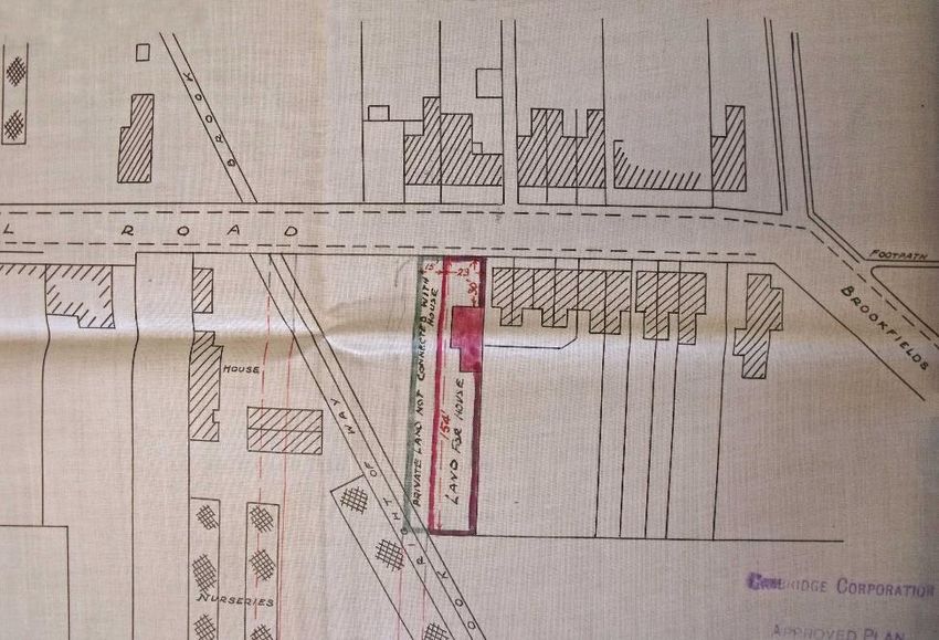
MILL ROAD HISTORY SOCIETY BUILDING/SITE REPORT                                       BROOKFIELDS AND BURNSIDE

                               Figure 3 – Extract from OS map of 1888 (augmented).
The Ordnance Survey (OS) map of 1888 (Figure 3 above) shows that building work had com-
menced on Brookfields and about six houses had been constructed by the mid-1880s, and
these were next to the junction with Montreal Road (possibly the current Nos 1 to 3 and Nos
9 to 15), with a short gap between. Burnside did not exist, it was merely a part of Snakey
Path. Note, however, the footbridge over Cherry Hinton Brook leading to the Tins (the foot-
path and cycleway that leads to the Church End part of Cherry Hinton), and the footpath run-
ning along the west side of the brook north to where Sainsbury’s presently is. Note too the
brook or ditch running south to north with almost the same alignment as Cherry Hinton
Brook: this would, in time, disappear from sight. The old Cambridge to Newmarket/Bury St
Edmund’s railway line runs west to east along the bottom.
The OS map of 1888 is a subsequent issue of that for 1886, so we can take it that this image
represents the situation around the middle of the 1880s.
A close inspection shows “B.P.” at Montreal Road. This marks the “boundary post” between
Cambridge and Cherry Hinton.
By the time of the 1903 OS map (Figure 4 below) things have changed considerably: most of
the houses have been built, Burnside (then still called Brookside) has become a street, and
the beginnings of Natal Road are in evidence. The un-named brook or ditch is still there, and
now it has a path running along its west side from Natal Road to Brookfields. Some green-
houses have been erected on both sides of the road around about where Perne Road and
Antwerp House2 are now. These belonged to the Green family, greengrocers of No. 34
Brookfields (see footnote 3 below).

2
   Antwerp House is the prominent dentists’ surgery standing at the northwest corner of the Brookfields/Brooks Road junc-
tion.

                                                           8
MILL ROAD HISTORY SOCIETY BUILDING/SITE REPORT                        BROOKFIELDS AND BURNSIDE

                       Figure 4 – Extract from OS map of 1903 (augmented)
                          (greenhouses are indicated by cross-hatching).

There is no mention of “B.P.” on this map as by that time this area had been incorporated
into the Borough of Cambridge.

                             Figure 5 – Extract from OS map of 1927

                                               9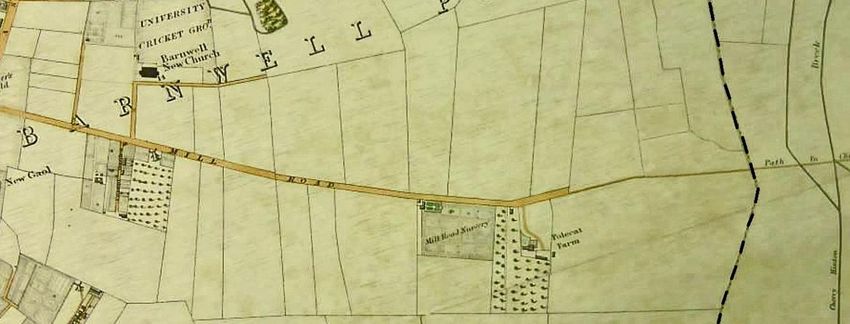
MILL ROAD HISTORY SOCIETY BUILDING/SITE REPORT                                        BROOKFIELDS AND BURNSIDE

Above (Figure 5) is the area in or shortly before 1927. Several things have changed since 1903.
No. 61 Brookfields has been built and it has a large building to the rear, possibly for storage;
Mr Green’s3 greenhouses extend south to Natal Road, where Miss G. Green’s house has been
built (now No. 44 Natal Road); the out-buildings behind No. 50 seem to have been reduced,
while various others have gone up around other houses. Brookside has now been changed
to Burnside (to avoid confusion with the Brookside by Trumpington Road). Furthermore, sev-
eral orchards have been planted and the railway line is now disused.
However, what are particularly noticeable are the developments in the land across Cherry
Hinton Brook – some new buildings and an entry road into the area from opposite No. 95
Burnside – the beginnings of the excavations (the quarrying of clay/marl for cement produc-
tion at the nearby Saxon and Norman cement works). The excavation sites south of the New-
market railway line later became inundated to form what is now referred to as either the
Cherry Hinton or the Burnside lakes – no final name has yet been established. The map shows
that there had been considerable excavation of the land that is today in the Army Reserve
centre. This work will have been done by the Saxon cement works which was then sited
where the Army Reserve area now is, across the brook from present-day Sainsbury’s.

                                     Figure 6 – Saxon Portland Cement works
                                 (www.britainfromabove.org.uk/image/epw025477)

The aerial photo above (Figure 6) shows the Saxon works with two large excavation pits sep-
arated by the new Newmarket railway line. The pit on the right (south) is inundated, and this
is the one in the 1927 OS map. The photo shows Coldham’s Lane running along the left
(north) side, and Cherry Hinton Brook running right to left in the bottom half, with the Atlas
Artificial Stone works where Sainsbury’s now stands. A short stretch of the Tins can just be
seen at the top right.4

3Mr Solomon Green was a man of some local importance. He lived at No. 34 Brookfields and had quite extensive land
holdings thereabouts, which, it seems, he used largely for cultivation, and had a number of substantial greenhouses. It may
be taken that Miss G. Green is a relative, possibly a daughter or sister.
4A report on the Romsey Town cement works (No. 2 in the MRHS series) can be found on the Capturing Cambridge website:
https://capturingcambridge.org/barnwell/coldhams-lane/norman-cement-works/

                                                           10
MILL ROAD HISTORY SOCIETY BUILDING/SITE REPORT BROOKFIELDS AND BURNSIDE
Figure 7 – Extract from OS 1:25,000 scale map of 1937
By the time of the 1937 map (Figure 7 above, ten years after that shown in Figure 5), Perne
Road/Brooks Road has sliced Brookfields in half and has rows of 1930s housing alongside it.5
Natal Road (eastern section) has been built up all along its south side. The Birdwood Road
area has been developed as have the Suez and Hobart road extensions and the Radegund
Road area. The Norman and Saxon cement works are operative though clay/marl excavation
has not yet commenced south of the Tins. The alignment of the old railway is clear.
Figure 8 – Extract from OS map of 1967
5For a full description of the development of Perne and Brooks roads please see section “The Development of Perne Road
and the Cutting in half of Brookfields” on p.22 below.
11MILL ROAD HISTORY SOCIETY BUILDING/SITE REPORT BROOKFIELDS AND BURNSIDE
Jumping ahead thirty years to 1967, we can see in Figure 8 that there has been substantial
development. No. 43 Brookfields has been erected, stepped back from the street, and there
has been in-filling at Nos 50 and 65. A builder’s yard is clearly labelled where Nos 83 and 85
Burnside now stand. The backs of Nos 97 to 109 Burnside are more or less as they currently
are, except for the recent house building at the rear of Nos 97 and 99. The eastern part of
Natal Road has largely been completed, and there is no longer any mention of a railway – a
Girl Guide’s hut is standing where locomotives would have once chugged through. The
Budleigh Close/Tiverton Way houses are yet to come.
The un-named brook or ditch (see figures 3, 4 and 5) has presumably gone underground,
though its alignment is still evident in some diagonal property boundaries in Figure 8.
There have been big changes on the land across the Cherry Hinton Brook. The block directly
opposite Burnside has been thoroughly excavated (this time by the Norman Cement Works,
then sited where the Holiday Inn Express and David Lloyd gym now stand) though it doesn’t
look as if it is yet a lake. There is further building in the land north of the Tins (marked “West
Bdy”) as the Army Reserve centre has developed. Indeed, local knowledge has it that the
large building across the bridge, fronting on to the Tins, was where school dinners were pre-
pared. After it had been decided it was better to prepare dinners in schools, the building was
used as a garage, which was shut down by the police after someone bought a car and drove
to the traffic lights at the end of Brookfields only to find that the brakes failed. Luckily every-
one escaped, apart from the garage.
Figures 9 and 10 (below), probably taken in the mid-1960s to early 1970s (judging by the car
in the Figure 10), show how Burnside looked in that period. The first one shows two people
cycling across the Tins bridge, then a relatively narrow wooden structure. Beyond lies Burn-
side, with only one parked car. Yet much looks very similar to 2020. The street lights are
shorter, there’s wall edging the side of No. 79, Nos 81, 83 and 85 are missing, and there are
no trees on the north side of the brook – this, apart from the lack of cars, is the main differ-
ence between then and now. The land across the brook had been excavated, yet perhaps not
rehabilitated and/or leased to the fishing association (which, it is understood, is responsible
for much of the tree-planting).
Figure 9 – 1960s/70s, origin unknown Figure 10 – 1960s/70s, origin unknown
12MILL ROAD HISTORY SOCIETY BUILDING/SITE REPORT BROOKFIELDS AND BURNSIDE
Figure 9 shows two cyclists crossing the bridge leading to The Tins. Figure 10 shows Burnside
from the east – from Snakey Path. Two youths are messing about at the point where the
brook goes through a grate and under the entrance to the lakes – though the second (east-
ernmost) excavation might not yet have been undertaken (remember that this is the align-
ment of the old railway). Snakey Path is somewhat rougher than it is today (2021), and a
stout pillar seems to impede cycle and pram access; the Burnside allotments are there (see
the compost dump on the side); yet trees are noticeably absent – there’s no substantial row
of fringing willows, the little patch of trees across from the bench is not there, and the Burn-
side front gardens are far less en-treed than they are now.
Figure 11 – Extract from OS map of 2002 (slightly augmented)
The 2002 OS map (Figure 11, above) is not a proper cadastral map; it’s from a regular 1:25,000
scale map. However, it does give a good indication of the situation in 2002, or a little bit
earlier.
The houses on Brookfields and Burnside, and Natal Road are largely as they presently are
(2021), the main exceptions being the unapproved one-storey “summerhouse” at the rear of
No. 93, the garage (now a building site) in the rear of Nos 97 – 99, and some extensions. No.
81 Burnside (the bungalow) has been built on land excised from No. 79, and Nos 83 and 85
have been erected on what was the builder’s yard. The Budleigh Close/Tiverton Way estate
has been built on what was previously allotment land.
On the other side of the brook, both pits are now inundated – indeed, the last of the cement
works, the Norman, ceased operations in 1984, the buildings being demolished in 1988.
Since 2002 there have been few structural changes. There have, though, been numerous
extensions to the rear of houses – ground floor, first floor or attic, or all three – but generally
the configuration of the houses has not greatly changed. Six or so houses have re-arranged
fenestration on their front elevation – reducing the size of the upper and lower windows, as
was considered desirable in the 1960s, ‘70s and ‘80s. Proposals for planning permission for
such alterations to the front façade would probably not be favourably received these days
13MILL ROAD HISTORY SOCIETY BUILDING/SITE REPORT BROOKFIELDS AND BURNSIDE
both Brookfields and Burnside being included in the Romsey Town section of the Mill Road
Conservation Area.6
House Numbering
In their first few decades the Brookfields and Burnside houses had a numbering system quite
different to their present one. The Brookfields numbers are somewhat confusing because (as
explained earlier) it was originally one unbroken street starting at the Mill Road/Montreal
Road junction and continuing to Burnside (then called Brookside). The making of Perne Road,
which cut Brookfields into two, occurred in the early 1930s.
Furthermore, there was no comprehensive numbering system for either of the streets – in
several cases discrete numbers were allotted to individual groups of terraces.
Brookfields
Figure 12 – Brookfields in 1904 with 2021 house numbers (adapted from 1903 OS map)
The house numbers in Figure 12 above are given as they currently are. Table 1 below shows
them as they were recorded in 1904.7
6As it happens, none of the houses in Brookfields and Burnside is recorded as either “listed” (meaning officially registered
as of national architectural or historic interest, and accordingly requiring protection), or “positive un-listed” or “local inter-
est” (meaning recognised as being of local architectural or historic interest). Hence, it seems that the houses of Brookfields
and Burnside might be included in the conservation area on the basis of their collective, rather than individual, architectural
and historical interest. The Mill Road Conservation Area remains what is generally termed a “paper conservation area” – a
delineation of the area without any specific development guidelines.
7 Based on the 1904 issue of Spalding’s Street & General Directory of Cambridge.
14MILL ROAD HISTORY SOCIETY BUILDING/SITE REPORT BROOKFIELDS AND BURNSIDE
South Side
2021 1904 Notes
Nos 1 to 7 Montreal Terrace, no numbers Now combined (Kip McGrath).
Nos 9 & 11 Brookfield Cottages, no numbers
Nos 13 & 15 Palmerston Houses, no numbers
Nos 17 to 25 Brook Terrace, no numbers The Brook was then called The Brookfield Tavern.
Nursery Now occupied by No. 31 Brookfields & Perne Road.
No. 43 - No. 43 did not exist in 1904.
No. 45 No. 1 Monmouth Terrace
No. 47 No. 2 Monmouth Terrace
No. 49 No. 3 Monmouth Terrace
No. 51 No. 4 Monmouth Terrace
No. 53 No. 5 Monmouth Terrace
No. 55 No. 6 Monmouth Terrace
No. 57 No. 7
No. 59 No. 8
No. 61 - Nos 61 didn’t exist in 1904.
- - There has never been a No. 63.
No. 65 Hinton Villa
North Side
2021 1904 Notes
No. 34 Brookfield House
Brookfield Nurseries Now occupied by No. 36 (Antwerp House) & Perne Road.
No. 48 Rose Villa
No. 50 Brook Villa
No. 52 No. 1 Brookfield Cottages
No. 54 No. 2 Brookfield Cottages
No. 56 No. 3 Brookfield Cottages
No. 58 No. 1 German Cottages
No. 60 No. 2 German Cottages
No. 62 No. 3 German Cottages
No. 64 No. 4 German Cottages
No. 66 Brook Villa
Table 1 – Brookfields house numbers 1904 and 2021
15MILL ROAD HISTORY SOCIETY BUILDING/SITE REPORT BROOKFIELDS AND BURNSIDE
It is a complicated arrangement, for both then and now. Note how there were two sets of
Brookfield Cottages in one street, and two Brook Villas. As to the names of the terraces,
cottages and houses, three stand out: Palmerston Houses: Were these named after Henry
Temple, 3rd Viscount Palmerston, Prime Minister in the 1850s and 60s, or perhaps the
builder’s best friend? Monmouth Terrace: Named after the town in the Welsh borders or the
1685 rebellion against James II? German Cottages: Named after a Germanophile or a local
property owner?8 Nonetheless, it is pleasing to see the emphasis put on the individual house
names.
Burnside
Figure 13 – Brookside (Burnside) 1904 (adapted from 1903 OS map)
with 2021 numbering
8 If you glance up at the inscription today you will see simply
“Cottages”, with a gap where there was once “German”. Legend
has it that “German” was chiselled off in a demonstration of patriotic fervour in either the First or Second World Wars. This
kind of thing went on throughout the UK. Indeed, in 1917 the royal family changed its name from the German Saxe-Coburg-
Gotha to the British Windsor. Furthermore, there was a local property owner named C. A. Germany – recorded in the 1920s
when the means of laying out of Perne Road were being explored. It has not been established whether there is a link
between the German Cottages and C. A. Germany.
16MILL ROAD HISTORY SOCIETY BUILDING/SITE REPORT BROOKFIELDS AND BURNSIDE
West Side (there is no East Side)
2021 1904 Notes
No. 67 No. 1 Brookside
No. 69 No. 2 Brookside
No. 71 No. 3 Brookside
No. 73 No. 4 Brookside
No. 75 No. 5 Brookside
No. 77 No. 6 Brookside
No. 79 No. 7 Brookside
Gardens Now occupied by Nos 81, 83 & 85.
- There has never been a No. 87.
No. 89 No. 8 Brookside
No. 91 Un-numbered
No. 93 Un-numbered
No. 95 Un-numbered Vine Cottage
Opening leading to Natal Road
No. 97 Rose Cottage
No. 99 Fern Cottage
No. 101 Un-numbered
No. 103 Un-numbered
No. 105 Un-numbered
No. 107 Un-numbered
No. 109 Brookside Cottage
Table 2 – Burnside house numbers in 1904 and 2020
There seems to have been a small error in Spalding’s 1904 recording, having eight addresses
prior to the “gardens” (where Nos 81, 83 and 85 currently stand); there are only seven.
By 1913, however, the numbering system we at present have had been adopted, and
Brookside had been changed to Burnside (to avoid any confusion with the other Brookside.
Why there is no No. 87 is a mystery.
Design and Construction
Have a glance up at the inscription on the front of some of the houses on Brookfields and you
can see the dates of their construction – Nos 58, 60, 62 and 64 (Cottages) in 1888, and No. 65
(Hinton Villa) in 1889. Looking around at the similarity of the other houses it is probable that
they too were built in the late 1880s, though it is quite possible that one or two date from the
17MILL ROAD HISTORY SOCIETY BUILDING/SITE REPORT BROOKFIELDS AND BURNSIDE
1890s, if not from the early 1900s. The exceptions are No. 61 (built sometime between 1904
and 1913), and No. 43 which quite clearly states 1927.
No dates are inscribed on any of the Burnside houses, though again, from the look of them
they date from the 1890s and 1900s – the exceptions being Nos 81, 83 and 85.
As is usual in many Romsey Town streets (and with 19th century terraced housing in general)
the houses in a street were erected though a combination of grouped and individual buildings.
The land would have been acquired from the landowner (possibly a farmer, though quite
probably a university college) by a speculator who would then demarcate the land into sale-
able plots. Who that speculator was has not been determined, though it could, of course,
have been the original landowner having an eye to likely demand and potential profit. The
plots would then be purchased by entrepreneurs (generally local), the houses built (by local
builders), and services – water supply, drainage and waste collection in particular – arranged
a few years later (see Utilities below).
In Brookfields (the eastern part) there are two sections of grouped terraced houses – Mon-
treal Terrace (Nos 53, 51, 49 and 47, and possibly 459) and (German) Cottages (Nos 64, 62, 60
and 58). Also, Nos 52, 54 and 56 appear to have been built by one developer – their elevations
and details are the same, as are Nos 55, 57 and 59. No. 50 has had a chequered history,
originally being one house including, seemingly, a shop, then two and now one again, though
an HMO (house of multiple occupation). Nos 43, 48, 50, 61, 65 and 66 are all individually
built, most of them with bay windows (No. 65, Hinton Villa, with an impressive two-storey
bay).
Burnside is a lot more mixed. Commencing from the junction with Brookfields, Nos 67 to 71
are very similar, though there are some small differences such as with the door and window
lintels, and there is a clearly visible dividing line in the facing brickwork: these buildings were
probably built individually though designed to be harmonious (this was a common practice).
No. 73 is individual, while Nos 75 and 77 seem to be a pair, with distinct red-brick banding.
No. 79 appears to be part of this group, though an alley separates it.
Next is No. 81, a bungalow erected in the mid to late 1980s with no reference to the vernac-
ular beyond the colour of the brick.
Then come Nos 83 and 85, built in the 1990s. They reflect the overall bulk of Nos 89 to 109
(actually, a bit bulkier, with bay windows) and make an attempt at following the local style by
including red-brick banding: But is it the fenestration and/or the lack of chimneys that pre-
vents them from fitting in architecturally? Here, though, appear the front gardens which are
a feature of the rest of Burnside.
Nos 89 and 91 appear to have been built as a pair and are relatively unadorned.
Nos 93 and 95, and Nos 97 and 99, are two pairs, though by the looks of them built by one
developer – the façade details are alike throughout. Here are bay windows and a central
chimney stack (now regrettably gone from 97 and 99), and side entrances – an uncommon
arrangement. However, these houses have only one first-floor window, while Nos 89 and 91,
of the same volume, have two. Furthermore, Nos 95, 97 and 99 have inscribed names (Vine,
9 “Possibly” as the terrace inscription was usually in the middle of the group, which in this case would have had No. 45 tacked
on to the side, which was quite common.)
18MILL ROAD HISTORY SOCIETY BUILDING/SITE REPORT BROOKFIELDS AND BURNSIDE
Rose and Fern10 Cottages) whereas No. 89, 91 and 93 have none. These houses could have
been built in a terrace of four save for the need to keep a gap open for access to Natal Road,
or it may have simply been the stepping back to align with the road.
Nos 101, 103 and 105 look as though they were built as one terrace, though the central chim-
ney stack between 101 and 103 might indicate that those two were a pair and No. 105 was
tacked on. There is no obvious break in the brickwork? Either way, here there are no bay
windows. Could this be due to their being fractionally smaller than Nos 95 to 99? The en-
trances are in the front.
Nos 107 and 109 are a pair, with a central chimney stack, with side entrances and again no
bay windows, though of very similar proportions to their neighbours. Of note is the side wall
of No. 107 – stone work, not brick. The house was occupied in its early years by Frank Saun-
ders, stonemason.
At the end is the alignment of the Great Eastern Railway to Newmarket. This stretch of the
line ceased to be used in the 1890s as a new alignment – the present one – was built to allow
for easier access to Cambridge Station. The old line was kept open until the late 1910s for
parking rolling stock.
Figure 14 – Extract from OS 1925 map
Figure 14 above shows the old railway route as it was in 1925. The new route is shown clearly
heading north to Coldham’s Common where it turns to join the main line into Cambridge. The
separation point of the old and new routes is just by the Norman Cement Works, which, by
1925, had yet to extend its excavation to dig out the lands between it and Cherry Hinton
Brook. The old line went past No. 109 Burnside, along what is now Budleigh Close, beside
Marmora Road, to bend south to join routes to Cambridge Station, or north, round the back
of Argyle Street, to join routes to Ely and beyond. Note how Perne Road had not yet been
thrust across Brookfields, how the housing along Coleridge Road was beginning to be laid out,
and how many allotment gardens there were.
The 1875 Public Health Act required the local municipal authority to ensure construction
standards, and this in turn necessitated the submission of building plans by the developer to
the local authority – an early form of planning approval. These plans are revealing, and the
Cambridgeshire Archives has a wealth of them submitted originally to the Borough of Cam-
bridge. Brookfields, however, was not in Cambridge but in Cherry Hinton, and Cherry Hinton
10
Enthusiasm for ferns, or pteridomania, was a craze in the late 19th century.
19MILL ROAD HISTORY SOCIETY BUILDING/SITE REPORT BROOKFIELDS AND BURNSIDE
was not incorporated into Cambridge until 1934. Furthermore it appears that the Parish of
Cherry Hinton came under the municipal authority of Chesterton Rural District, which was
extensive and included much of what was physically, though not municipally, Cambridge.
Hence, building plans had to be submitted to Chesterton – and the ones for Brookfields and
Burnside seem to be missing.
The only plan that has been unearthed is the “building byelaw plan” for No. 43 Brookfields.
The application was submitted in October 1927 by Solomon Green – of No. 34 Brookfields
(now in the western part). The file was given to the archives by the Municipal Corporation of
Cambridge; why it came from there and not Chesterton is unclear.
20MILL ROAD HISTORY SOCIETY BUILDING/SITE REPORT BROOKFIELDS AND BURNSIDE
Figure 15 – Building byelaw plan for detached house, No. 43 Brookfields, Mill Road (CA: CB/2/SE/3/9/6320)
Although dated 1927, these plans are much the same as those from the 1880s–1900s, the
period when the other houses went up; the design is very conventional except for the inclu-
sion of the bathroom on the first floor – earlier houses of this type would not have had this
luxury.
It is a handsome three-bedroom house, entered via a passageway, bay-windowed and with a
fire place in all main rooms except the kitchen. In the kitchen there is a sink, the traditional
“copper”,11 larder, coal store and space for a cooking range. The W.C. is accessed from the
outside, as was the custom. It is likely that when built it had no electricity infrastructure,
though gas piping may have been included.
The location plan shows the odd stretch of land that currently lies between the house grounds
and Perne Road.12 Here it is described as “private land not connected with house”. The plan
shows that it is 15 feet wide and 154 feet long – too narrow for much use. Why didn’t Mr.
Green simply include it in the house’s garden? As described in footnote 3, Solomon Green
was the owner of the quite substantial market gardening business that occupied land lying
between “west” and “east” Brookfields.
11An early form of boiler – a brick-built fireplace with large copper basin on top, for heating quantities of water larger than
a kettle could.
12
Though Perne Road is not shown on this location plan, by 1926/27 it must have been common knowledge that the road
was going to proceed. Perhaps this wedge of land was supposed to act as potential buffer.
21MILL ROAD HISTORY SOCIETY BUILDING/SITE REPORT BROOKFIELDS AND BURNSIDE
Utilities
Each house would have been built with the means of water supply – pipes, taps, and generally
a sink or maybe two – yet connection would be a private arrangement with the local water
company. Connection to gas and electricity were through individual arrangements, presum-
ably undertaken by the property owner, and the latter seems to have been rare up to the
1920s and 30s.13
Sewerage was then a municipal affair, and householders would have to enter into a contract
with the municipal authority. An example is the November 1913 “drainage agreement” be-
tween the developer – Charles Howard Smith, grocer of Cherry Hinton – and the “the mayor,
aldermen and burgesses of the borough of Cambridge”, the witness being one Charles Scott,
builder from Cherry Hinton, and probably the builder of the houses. Mr Smith had two “mes-
suages” (i.e. dwellings) in Brookside (now Burnside) (CA ref: CB/2/C2/is/12/296).
Often houses would initially be served by a pit latrine14 in the backyard – which had
implications for the length of the back yard – yet as standards were improved connection to
the main sewerage system became axiomatic.
The Development of Perne Road and the Cutting in Half of Brookfields
As we have seen, Brookfields used to be one unbroken road – continuing the alignment of
Mill Road from its junction with Montreal Road to Burnside. It is now sliced in two by Perne
Road – as is Natal Road. Why and how did this happen?
Jesus College (full name: the College of the Blessed Virgin Mary, Saint John the Evangelist and
the Glorious Virgin St Rhadegund) was the owner of the extensive lands – then largely fields
– lying between Mill Road (to the north), the railway (to the west), Cherry Hinton Road (to
the south), and beyond to the east (the estate continued north of Mill Road up to Stourbridge
Common).
13In some cases later: the 1944 auction brochure for No. 66 Brookfields states that it had water, gas and electricity only on
the ground floor (CA ref: 515/SP 1799).
14Pit latrine: a pit, with a slab at the surface, with drop-hole, for urine and faeces. When sewerage connection later took
place, presumably such pits were filled in.
22MILL ROAD HISTORY SOCIETY BUILDING/SITE REPORT BROOKFIELDS AND BURNSIDE
Figure 16 – The red line indicates the boundary of part of the Jesus College estate in the Romsey
Town vicinity, with draft road layout for possible future development (Jesus College Archives, 1927)
By the late 1920s the college assumedly came to acknowledge that it was sitting on a gold
mine and had plans drawn up for the development of its estate. Figure 16 above gives an
indication of the initial proposals for housing in the area from Perne Road to Rustat Road –
then labelled the Station Building Estate.
Apart from the road layout (which was only draft), one relevant feature on this map is that
Jesus College may have been the owner of the land upon which Brookfields and Burnside
were built – this has not been ascertained, and the map may be a generalisation.15 However,
what is critical is the mooted Perne Road alignment, which cuts through Brookfields to join
up with Coldham’s Lane farther to the north.
Once the plan had been approved by Jesus College and the Borough the severance of Brook-
fields became a technical matter: where and how the new road would be made.
15 Besides, all these properties are surely now freehold.
23MILL ROAD HISTORY SOCIETY BUILDING/SITE REPORT BROOKFIELDS AND BURNSIDE
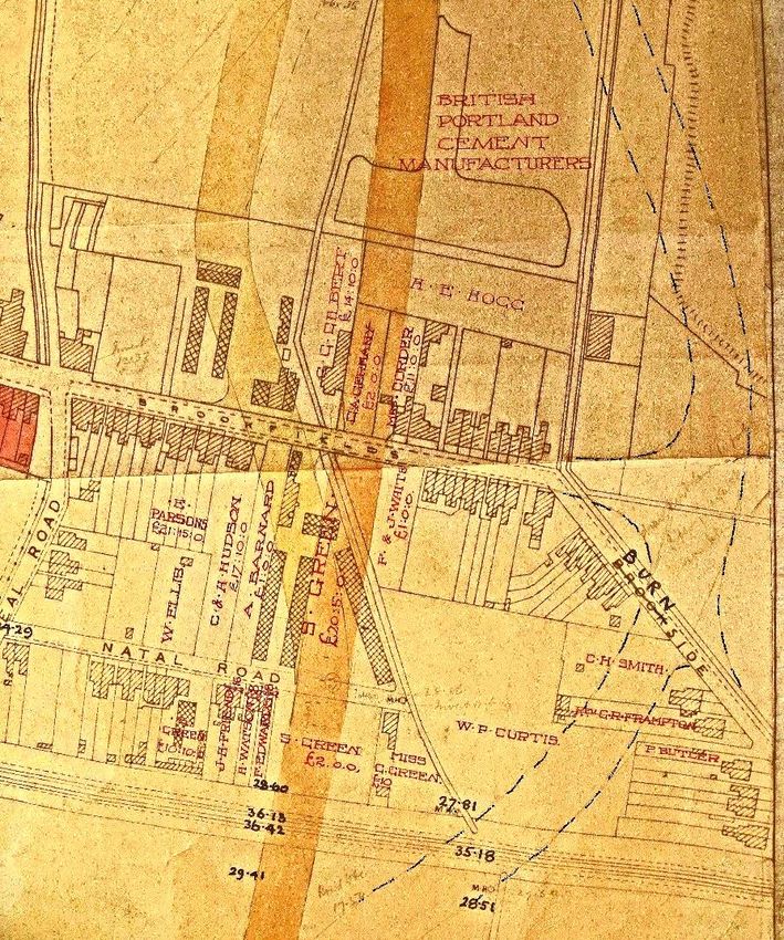
Figure 17 – Outline plan of options for Perne and Brooks Road alignment, 1931 (CA CB/2/SE/1/Roll 42/30)
Figure 17 above shows some proposals for Perne Road alignment. The main one (the thick
darker line) appears to be the one that was decided upon. It avoids all structures apart from
Mr. Green’s greenhouses and a shed next to No. 48. The second (lighter) option branches off
to the north west and would require the demolition of more structures, including Mr. Green’s
house, but it may have been avoiding land owned by “British Portland Cement Manufactur-
ers”, which might have been costly. There is an interesting third option (the original pencil
line has been strengthened) which went to the east of Brookfields, cut Burnside into two, and
fed on to Snakey Path.
The map also reveals the land owners that would be affected and gives an indication of the
costs of compensation. At the bottom, south of Natal Road (which was then wholly a cul-de-
sac), there is S. (Solomon) Green (£2.00) and Miss G. Green (£10.00).16 North of the road
there is S. Green again (£20.5.0). Mr. Green, of No. 34 Brookfields, was (as we have seen) a
16
Miss G. Green’s house, which would be cut off by Perne Road, is taken to be the current No. 44 in the eastern section of Na-
tal Road.
24MILL ROAD HISTORY SOCIETY BUILDING/SITE REPORT BROOKFIELDS AND BURNSIDE
local man with a seemingly extensive market gardening business; Perne Road would go right
through his greenhouses. Proceeding north it would clip No. 48 Brookfields, where Mrs
Corder (the owner, not the occupant) would require £11.00. Next to her was C. A. Germany,17
with no structure and therefore deemed worth only £2.00, and next again is C. G. Gilbert,
requiring £14.00 – this is taken to be the current Antwerp House.
Some of the other eastward landowners shown are: W. P. Curtis, owner of a large block of
then undeveloped land where the eastern section of Natal Road now lies; P. Butler, owner of
No. 97 Burnside; the Reverend G. R. Frampton, owner of Nos 95 and 93 Burnside; C. H. Smith
of Nos 91 and 89 Burnside, and the undeveloped land up to No. 79; F. & J. White of the then
undeveloped No. 43 Brookfields; H. E. Hogg of an undeveloped block lying between Cherry
Hinton Brook and the current Brooks Road.18
Note that F. & J. White are recorded as owners of the site of No. 43 Brookfields. As mentioned
above, this was the location of Solomon Green’s 1927 application to build No. 43. It might be
assumed that once the route of the road had been officially decided, Mr. Green, taken as
being quite savvy, bought the remainder of the land from the Whites and put in his housing
application. Though it still remains a mystery why that narrow stretch of private land is there.
What else does the map reveal? That British Portland Cement Manufacturers (then the own-
ers of the Saxon and Norman Cement Works, now the Army Reserve site and the Holiday Inn
Express and David Lloyd Gym) had large land holdings thereabouts, and that “Burn” had to be
superimposed on “Brook”side.
There is, however, some confusion, this time over land ownership. Figure 16 shows land
within the red line supposedly owned by Jesus College. Yet another map (Figure 18 below,
titled Cambridge (East) Town Planning Scheme (1927)) shows the land lying immediately east
of the then brand new Perne Road as owned by The Master, Fellows and Scholars of Peter-
house. Was there a discrepancy, or did Jesus College sell those lands to Peterhouse after the
new Perne Road had been developed?
17 The builder of the German Cottages? Cf. footnote 8 above.
18Why the name changed from Perne to Brooks Road has not been discovered. Road names in the vicinity are somewhat confus-
ing.
25MILL ROAD HISTORY SOCIETY BUILDING/SITE REPORT BROOKFIELDS AND BURNSIDE
Figure 18 – Cambridge (East) Town Planning Scheme, 1927 (augmented) (CA CB/2/SE/3/2/10)
The designation of the area as a town planning scheme doesn’t seem to have resulted in
much: block 118 (outlined in green) was intended to be allotments – it is now all housing (the
Chalmers Road area); block 115 does now have the Burnside allotments and the Tiverton Way
housing; and 120 and 121 are now St. Bede’s school.
Social and Economic Change and Valuation
Obviously, the values of the houses on Brookfields and Burnside have changed greatly since
the time they were built. When these streets were laid out during the 1880s–1900s, this part
of Romsey Town was not considered upmarket. The two neighbouring cement factories
(Saxon and Norman) emitted enough dust, smell and noise to provoke strong protest from
the locals and from local councillors. The houses were generally small – few had more than
two bedrooms – and neighbourhood amenities were relatively scarce, except for the then
wide range of shops in Mill Road. Many people associated with the University had little or no
knowledge of the area – it was decidedly “town”, not “gown”.
A look at the trades of some of the occupants recorded in the Spalding’s directories between
1904 and the mid-to-late 1930s gives an idea of who lived here. In Brookfields there were
five cement workers, five railway men, ten labourers, a packer, coal and coke merchant, cor-
poration servant, two bricklayers, a blacksmith, carpenter, dairyman, clerk and a garner. In
Burnside there were seven labourers, two cement workers, two carpenters, a grocer’s assis-
tant, bricklayer, railway man, tailor, baker, stonemason, motor-driver, and an insurance
26MILL ROAD HISTORY SOCIETY BUILDING/SITE REPORT BROOKFIELDS AND BURNSIDE
agent. These are all good occupations, but unlikely to enable substantial savings to mount
up.
What this lack of ready capital entails is illustrated below in the 1893/94 case of William Ta-
bor. He was a greengrocer and resident of Brookfields (though not recorded in Spalding’s di-
rectories). In 1893 his horse, a vital asset, died, and assumedly having little or no savings he
applied to the Cambridge Charity Organisation Society for a loan to buy a new one. The file
gives some interesting detail. He was 41 and his wife Elizabeth (housewife) was 39. They had
six children – a daughter of 18 in service, 15-year-old Frederick working as a gardener at the
Leys School, 11-year-old Harry, a “workman”, Robert aged 6, Emily aged 5, and a one-month-
old baby. It also states that they occupied seven rooms, “clean and comfortable”, and two
greenhouses. The only house that could have seven habitable rooms, with a garden large
enough for two greenhouses, is surely No. 50. The rent was £17 per annum. Mr Tabor’s
character references were Mr Gillett (landlord), Mrs Pascoe (shopkeeper), Mr Cowell (carter
and coal dealer, Mill Road), and Mr Ward (baker) (CA Case 2500 of 1893/940). Despite all of
this, it seems that his application was unsuccessful.
Perhaps it is the changing face of Mill Road that reflects the social and economic transfor-
mation hereabouts. It appears that shops catering to household needs – hardware, groceries,
etc. – are today (2021) gradually being replaced by restaurants, take-outs, cafés and enter-
tainment businesses.19 Many a household in Romsey Town will shop at supermarkets and
only go to Mill Road for a coffee and a snack or a meal out.
However Cambridge, as has been stated in numerous reports, is an economic boom town,
and this is directly reflected in house prices. Romsey Town might have been “Red Romsey”
in the 1920s, but that radicalism has become somewhat compromised over the years and the
area is now distinctly inner-city “des-res”.
In the 1960s and 70s, streets of Victorian and Edwardian “working class” terraced housing
was often identified as sub-standard and designated for demolition and re-building; yet Rom-
sey was included in the Romsey General Improvement Area (GIA20) in the late 1970s and early
1980s. Though few houses in Brookfields and Burnside actually qualified for improvement
grants, any ideas of comprehensive redevelopment were evaded.
Since then, and particularly in the 2000s, a combination of factors seems to have resulted in
significant changes. Professional and academic employment has increased, leading to more
people (whether Cantabrigian or from other places) seeking housing; inner-city terraced
housing has come to be perceived as desirable; amenities have improved; prices may be com-
petitive with other locations; older residents have moved on. For Brookfields and Burnside
there are added factors – relative proximity to the railway station, the ambience of the lake-
side location (albeit closed to the public), and the closure of the blighting activities of the
19For example, this was stated as the main reason given by the owners of Kailash – household and hardware shop on Mill
Road – when it recently closed down.
20 GIAs were a central government intervention in urban improvement. They were, essentially, area-based housing improve-
ment schemes, and local councils were able to declare areas of run-down though basically sound housing as GIAs and make
grants available for improvements. This was intended to encourage lending institutions to invest in areas of low rateable
value.
27MILL ROAD HISTORY SOCIETY BUILDING/SITE REPORT BROOKFIELDS AND BURNSIDE
cement works – though Cambridge airport continues occasionally to blight the area with a
phenomenal racket.21
Suffice to state that when No. 3 Monmouth Terrace (No. 49 Brookfields) was auctioned by
Scruby & Gray in 1917 (“three rooms on ground floor and three rooms on upper floor”) it was
“producing” an annual rent of £10.12.4 (CA 107/SP/45), calculated as being around £710 in
2021 prices.
In 1938 No. 58 Brookfields was auctioned (by A. F. Lofts), the annual rent being stated as £14.6
(approximately £1,016).
When auctioned in 1940 (by Robert W. Bell & Son) Nos 54 and 56 Brookfields were sold for
£200 each (approx. £12,000 in 2021 terms). No. 52 went for £300 (£17,000) in the same auc-
tion.
The 1970s/early 1980s sale brochure (Drivers), asked for offers of around £21,500 for the
“modernised” No. 47 Brookfields (CA SP20/409). This would be somewhere around £95,000
in 2021.
Lately, house values have accelerated. In 1996 a house in the streets was bought for £78,000;
in 1999 it was sold for £139,000. A two-bedroom house was sold in 1999 for £114,000; in
2007 for £265,500. Another two-bedroom house was sold in 2004 for £150,000 and again for
£248,000 in 2011. Indeed, a three-bedroom house was sold in 2003 for £189,500, then again
in 2014 for £375,000, and yet again in 2018 for £487,000.22
The Houses
The tables below are based on information gained from the Spalding’s Directories (1874 to
1940), and the Kelly’s Directories (1948 to 1975), from the Cambridge City Planning Depart-
ment’s website (https://applications.greatercambridgeplanning.org/online-applications/),
from www.rightmove.com, and from Samuel (Keith) Lagdon, long-time resident of No. 66
Brookfields.
Brookfields
No. 66 Brookfields
Date Occupants Events
1904 Arthur Clarke Un-numbered, recorded as “Brook Villa”.
1913 A. Sargent Recorded as No. 66.
1935/36 E. Salmon, cement worker
1944 Alfred Chivers Auctioned. Execution of will of Mrs Beatrice Alice Sebley. Ground floor: small entrance lobby, sitting
room with bay window & fireplace, living room with fireplace, kitchen – scullery with portable range,
glazed white sink. First floor: double bedroom with fireplace, front double bedroom with fireplace &
21 Cambridge Airport has stated that it intends to relocate, opening up its area for a considerable amount of housing.
22The website www.in2013dollars.com/uk/inflation has been used to estimate the effect of inflation. It may not be precisely
correct but probably gives a good indication.
28MILL ROAD HISTORY SOCIETY BUILDING/SITE REPORT BROOKFIELDS AND BURNSIDE
gas lighting, back bedroom. Water & electric lighting only on ground floor. WC & coalhouse. Kitchen
garden & air raid shelter. Rent 13s per week (CA 515/SP 1799).
1948 Rt Lagdon, labourer
1953 Rt Lagdon
1964 Rt Lagdon
1967 Rt Lagdon
1973 Rt Lagdon
1988 Approval of application for part single part double storey extension .
No. 65 Brookfields
Occupants Events
Date
1904 Fredrick Brigham Un-numbered, recorded as “Hinton Villa”.
1913 Fredrick Brigham, clerk Recorded as No. 65.
1935/36 C. H. Cracknell, fireman LNER
1948 Christopher H. Cracknell, Cherry Hinton church warden
1953 Christopher H. Cracknell
1964 Christopher H. Cracknell
1967 Christopher H. Cracknell
1973 Harry Cracknell
2004 Withdrawal of application for roof extension.
2005 Approval of application for rear roof extension.
No. 64 Brookfields
Date Occupants Events
1904 Frederick Wilderspin Recorded as No. 4 German Cottages 1888.
1913 Frederick Wilderspin, labourer Recorded as No. 64.
1935/36 Frederick Wilderspin, labourer
1948 Frederick Wilderspin
1953 Frederick Wilderspin
1964 Frederick Wilderspin
1967 Frederick Wilderspin
1973 - Approval of application to erect two-storey extension.
1978 Approval of application to erect front porch.
There is no No. 63 Brookfields.
29MILL ROAD HISTORY SOCIETY BUILDING/SITE REPORT BROOKFIELDS AND BURNSIDE
No. 62 Brookfields
Date Occupants Events
1904 Henry H. Wright Recorded as No. 3 German Cottages 1888.
1913 Sidney Dean Recorded as No. 62.
1935/36 H. Wilderspin, packer
1948 Herbert C. Wilderspin
1953 Herbert C. Wilderspin
1964 Herbert C. Wilderspin
1967 Herbert C. Wilderspin
1973 Herbert C. Wilderspin
1978 Approval of application to erect front porch.
1982 Approval of application to erect 1st floor extension.
No. 61 Brookfields
Date Occupants Events
1904 Unbuilt .
1913 E. Potter, coal & coke merchant
1935/36 E. Potter, coal & coke merchant, and haulage contractor (Kia Ora)
1948 Lawrence Arthur Jakes, taxi driver
1953 Lawrence Arthur Jakes
1964 H. Bird Jr, maintenance man at Addenbrookes
1967 H. Bird Jr
1973 H. Bird Jr
1988 Approval of application to erect two storey side extension.
No. 60 Brookfields
Date Occupants Events
1904 William Watts, labourer Recorded as No. 2 German Cottages 1888.
1913 William Watts, labourer Recorded as No. 60.
1935/36 Fred Baker, painter
1948 Walter Rt Hardy, fueller at Marshall’s
1953 Walter Rt Hardy
1964 Walter Rt Hardy
1967 Walter Rt Hardy
1973 Walter Rt Hardy
30MILL ROAD HISTORY SOCIETY BUILDING/SITE REPORT BROOKFIELDS AND BURNSIDE
No. 59 Brookfields
Date Occupants Events
1904 Arthur Hayes Recorded as No. 8.
1913 Charles Bedwell, cement labourer Recorded as No. 59.
1935/36 C. F. Doggett, corporation servant
1948 Chas F. Doggett
1953 Chas F. Doggett
1964 Chas F. Doggett
1967 Chas F. Doggett
1973 Chas F. Doggett
1981 Approval of application to erect front porch.
No. 58 Brookfields
Date Occupants Events
1904 William C. Cracknell, labourer Recorded as No. 1 German Cottages 1888.
1913 William C. Cracknell, labourer Recorded as No. 58.
1935/36 George Jasper
1938 G J Dunsdon Auctioned. Two sitting rooms (front with Register stove, back with range), kitchen (sink and copper
& point for gas), three bedrooms (front & middle with stove).
Outside WC & coal store. No electricity. Annual rent £14.6.0 per annum (CA 515/SP1575).
1948 Mrs B Odell
1953 Mrs B Odell
1964 Mrs B Odell
1967 Mrs B Odell
1973 Samuel Lagdon, commercial
vehicle body builder
No. 57 Brookfields
Date Occupants Events
1904 L. Gawthrop, labourer Recorded as No. 7.
1913 Harry Shipp, labourer Recorded as No. 57.
1935/36 Harry Shipp, labourer
1948 Harry Shipp
1953 Harry Shipp
1964 Mrs Shipp, retired sisters
31MILL ROAD HISTORY SOCIETY BUILDING/SITE REPORT BROOKFIELDS AND BURNSIDE
1967 Mrs Shipp
1973 Mrs Shipp
2002 Approval of application to erect single storey front extension.
No. 56 Brookfields
Date Occupants Events
1904 William Harding, labourer Recorded as No. 3 Brookfield Cottages.
1913 Lawrence Simmonds, garner Recorded as No. 56.
1935/36 Charles Taverner, labourer
1940 Chas Taverner Auctioned. Acting on instructions of will of John Hardwick. Front & back living rooms with Register
stoves, kitchen with sink & copper & pantry, outside WC. Iron palisaded fences at front. Rent £28.12
pa (CA 515/SP 1695).
1948 Chas Taverner
1953 Chas Taverner
1964 Chas Taverner
1967 Chas Taverner
1973 Chas Taverner
No. 55 Brookfields
Date Occupants Events
1904 George Hunt, labourer Recorded as No. 6.
1913 Walter Edwards, cement worker Recorded as No. 55.
1935/36 P. G. Shadbolt, college servant
1948 Percy G. Shadbolt
1953 Percy G. Shadbolt
1964 Percy G. Shadbolt
1967 Percy G. Shadbolt
1973 Percy G. Shadbolt
No. 54 Brookfields
Date Occupants Events
1904 Ezra Phillip Dobson, bricklayer Recorded as No. 2 Brookfield Cottages.
1913 Charles Brown, shunter GER Recorded as No. 54.
1935/36 W. R. Street, signalman
1940 Frederick Taverner Auctioned. Acting on instructions of will of John Hardwick. Front & back living rooms with Register
stoves, kitchen with sink & copper & pantry, outside WC. Iron palisaded fences at front. Rent £28.12
pa (CA 515/SP 1695).
32MILL ROAD HISTORY SOCIETY BUILDING/SITE REPORT BROOKFIELDS AND BURNSIDE
1948 Frederick Taverner
1953 Frederick Taverner
1964 Clifford Matthews, engineer
1967 Clifford Matthews
1973 Clifford Matthews
No. 53 Brookfields
Date Occupants Events
1904 Archibald Douglas, blacksmith Recorded as No. 5 (Monmouth Terrace).
1913 Alfred Sadler, railway employee Recorded as No. 53.
1935/36 Thomas John Nelson, labourer
1948 Harry Chas Powter
1953 Harry Chas Powter
1964 Harry Chas Powter
1967 Harry Chas Powter
1973 Harry Chas Powter
1982 Approval of application to erect two storey extension.
1984 Approval of application to erect single storey front extension.
No. 52 Brookfields
Date Occupants Events
1904 A. Smith, bricklayer Recorded as No. 1 Brookfield Cottages.
1913 Walter Smith, bricklayer Recorded as No. 52.
1935/36 J. Hardwick
1940 Auctioned. Acting on instructions of will of John Hardwick. Front & back living rooms with Register
stoves, kitchen with sink & copper & pantry, outside WC. Iron palisaded fences at front. Rent £28.12
pa (CA 515/SP 1695).
1948 Mrs A Jarman
1953 Leonard Stanley Clark Owned a Lanchester car.
1964 Denis Bowles
1967 Denis Bowers
1973 Denis Bowers
2015 Approval of application to erect Part two storey, part single storey rear extension following
demolition of lean-to, plus loft conversion.
2016 Approval of application to erect part two storey, part single storey rear extension & loft extension.
33You can also read