Bushfire Management Plan - Rokeby Hills Reserve Howrah - Revised January 2017 Clarence City Council
←
→
Page content transcription
If your browser does not render page correctly, please read the page content below
Clarence City Council

Bushfire Management Plan

Rokeby Hills Reserve
Howrah

                                      Revised
                               January 2017
                        Clarence City Council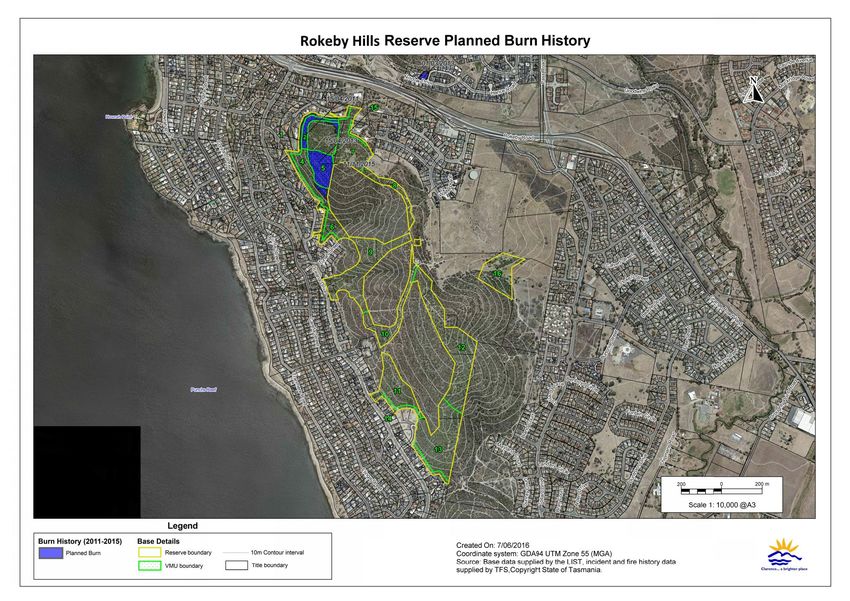
Contents
                                                                                                                                             Page

1.   Introduction ............................................................................................ 1
      1.1     Aim….. ............................................................................................................ 1
      1.2     Location and Description ............................................................................. 2
                1.2.1     Geology and Soils ................................................................................................. 2
                1.2.2     Vegetation .............................................................................................................. 5
                1.2.3     Reserve Usage ....................................................................................................... 6

      1.4     Bushfire Management Objectives ............................................................... 8
      1.5     Reserve Management Responsibilities ..................................................... 10
      1.7     Conservation Covenants ............................................................................ 10
2.   Bushfire Risks ...................................................................................... 14
      2.1     Bushfire History and Causes ..................................................................... 14
                2.1.1     Bushfires ................................................................................................................14
                2.1.2     Planned Burning ..................................................................................................14

      2.2     Fuel Types and Hazard Levels .................................................................. 17
      2.3     Bushfire Threat and Risk to Persons......................................................... 20
      2.4     Assets at Risk from Bushfire ...................................................................... 20
                2.4.1     Bushfire Risk to Natural Heritage Assets .........................................................22
                2.4.2     Bushfire and Habitat Management ...................................................................25
                2.4.3     Bushfire Risk to Built and Cultural Assets .......................................................29

3.   Bushfire Management Issues............................................................ 37
      3.1     Existing Bushfire Management ................................................................. 37
                3.1.1     Implementation of the Previous BMP ...............................................................37
                3.1.2     Planned Burning ..................................................................................................37
                3.1.3     Vehicle Entry Points, Fire Trails and Foot Tracks ...........................................37
                3.1.4     Water Supply ........................................................................................................46
                3.1.5     Fuel Breaks ............................................................................................................46
                3.1.6     Defendable Spaces ...............................................................................................46
                3.1.7     Bushfire Detection and Suppression .................................................................48

      3.2     Weeds… ........................................................................................................ 49
      3.3     Rubbish Dumping ....................................................................................... 49
      3.4     Stakeholder and Community Concerns ................................................... 50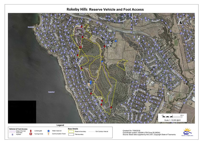
4.       Plan Implementation .......................................................................... 51
           4.1        Bushfire Risk Reduction Strategy ............................................................. 51
           4.2        Community Education, Awareness and Involvement .......................... 51
           4.3        Planned Burning .......................................................................................... 52
                         4.3.1        Vegetation Management Units (VMU) .............................................................52
                         4.3.2        Planned Fire Regimes ..........................................................................................52
                         4.3.3        Preparation and Supervision ..............................................................................53

           4.4        Bushland Management ............................................................................... 59
                         4.4.1        Control of She Oak (Allocasuarina verticillata) ..................................................60

           4.5        Formalised Monitoring ............................................................................... 60
5.       Bushfire Management Recommendations ..................................... 61
           5.1        Management Action Summary ................................................................. 62

 References

Appendix A – Implementation of the previous bushfire management plan

                                                                      FIGURES
                                                                                                                                                                Page

FIGURE 1 – LOCATION OF THE RESERVE........................................................................................................... 3

FIGURE 2 – TASMANIAN INTERIM PLANNING SCHEME ................................................................................... 4

FIGURE 3 – NATIVE VEGETATION TYPES IN AND ADJOINING THE RESERVE ................................................... 7

FIGURE 4 – MAPPED BUSHFIREAPRONE AREAS UNDER THE CLARENCE INTERIM PLANNING SCHEME 2015
      (CIPS 15) ................................................................................................................................................... 9

FIGURE 5 – EXTENT OF CONSERVATION COVENANT ......................................................................................13

FIGURE 6 – RESERVE BUSHFIRE HISTORY (1967–2015) AND ATTENDED TFS INCIDENTS OF RESERVE (2011A
      2016).........................................................................................................................................................15

FIGURE 7 – PLANNED BURN HISTORY (2011A2015) ........................................................................................16

FIGURE 8 A ASSETS AT RISK FROM BUSHFIRE ...................................................................................................21

FIGURE 9 – VEHICLE AND FOOT ACCESS.........................................................................................................39

FIGURE 10 – VEGETATION MANAGEMENT UNITS IN THE RESERVES .............................................................54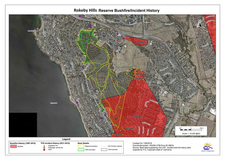
TABLES
                                                                                                                               Page

TABLE 1 – CHARACTERISTICS OF THE DIFFERENT FUEL TYPES IN THE RESERVES ............................................19

TABLE 2 – CONSERVATION VALUE OF NATIVE PLANT COMMUNITIES ............................................................22

TABLE 3 A PLANT SPECIES OF CONSERVATION VALUE AND PREFERRED BUSHFIRE MANAGEMENT ...............23

TABLE 4 – FIRE ATTRIBUTES OF THE NATIVE VEGETATION..............................................................................24

TABLE 5 A BUSHFIRE MANAGEMENT REQUIREMENTS OF THE PLANT COMMUNITIES IN THE RESERVES .........27

TABLE 6 A BUSHFIRE RISK ASSESSMENT FOR BUILT AND CULTURAL ASSETS....................................................32

TABLE 7 – CONDITION, MAINTENANCE AND REQUIRED ESTABLISHMENT OF FIRE TRAILS IN THE RESERVE..40

TABLE 8 – BUSHFIRE MANAGEMENT IN THE RESERVE .....................................................................................55

PROJECT TEAM
Rob Whittle                               A Clarence City Council A Fire and Bushland Vegetation
                                             Management Works Officer
Pat Marshall                              A Clarence City Council – Fire and Bushland Vegetation
                                             Management Coordinator
Gregg Jack                                A Clarence City Council – Systems Asset Officer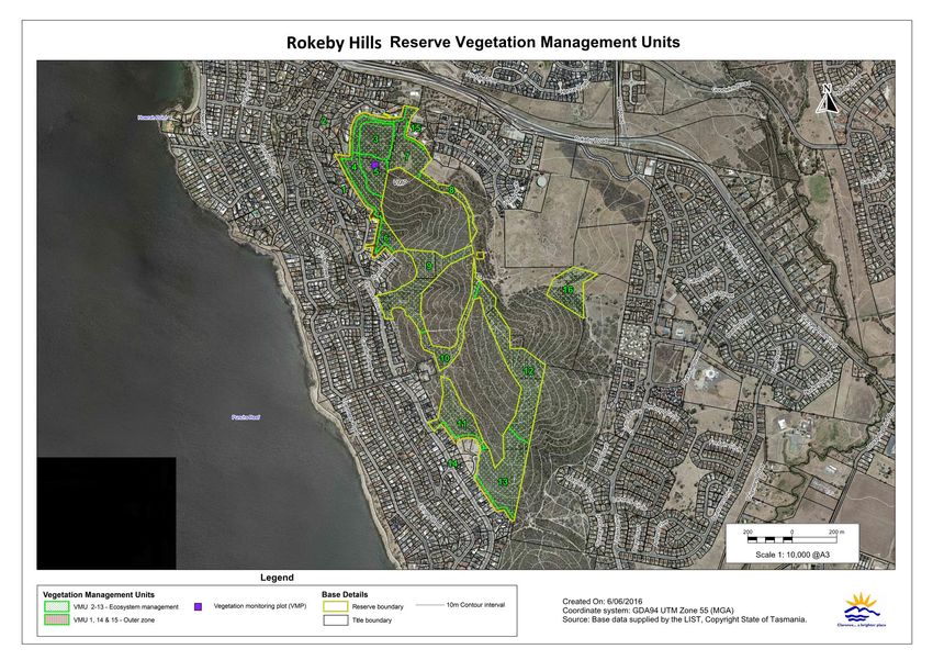
Rokeby Hills Reserve Bushfire Management Plan                                        Revision 2, January 2017

1.         Introduction
This bushfire management plan (BMP) is the second revision of the initial BMP for Kuynah
Bushland Reserve (now known as Rokeby Hills Reserve) prepared by AVK Environmental
Management and Renaissance Forestry in 2005, and will operate for a period of 5 years after which
another review is recommended. This BMP includes Toorittya Bushland Reserve (approximately
.5ha located at 534 Oceana Drive, Howrah) and approximately 32ha of public open space (POS)
throughout Rokeby Hills formerly owned by Malwood PTY LTD, acquired by Council in 2016 as
an offset for impacts associated with adjacent residential development.

Sections of the reserve are covered by a Conservation Covenant stipulating activities on, or in
relation to, the land which will cause damage to, or degradation of, the natural values (see figure 5
for extent of covenant).

It should be noted that this BMP is not an operations plan and does not deal directly with
“response” to bushfires. Operational procedures are dealt with in various documents prepared by
the Tasmania Fire Service (TFS) and other emergency services.

1.1             Aim
The aim of this BMP is to provide a framework for bushfire management that meets Clarence City
Council’s land management objectives for the site, as set out in Council’s Bushfire Management
Strategy for Council Owned and Controlled Land, Bushfire Management Strategy - Best Management
Practice Guidelines and Strategic Plan.

It must be noted that it will not be possible to prevent bushfires occurring in the reserves. Unless
these fires are suppressed quickly, there is a risk that large destructive fires may develop.
Depending on weather conditions, such fires may burn a substantial portion of the bushland in
and adjoining the reserve causing damage to assets and environmental values, and even loss of
life. This BMP aims to lessen these risks by minimising the risk of fires starting in the reserve, and
minimising the risk of injury or damage to assets in and surrounding the reserve.

This plan also provides for the use of fire as a management tool to:

•    Target area for maximum risk reduction

•    reduce bushfire hazard to protect assets from bushfires

•    maintain the longAterm viability of the native vegetation in the reserve

•    Assist in the removal of weeds and the regeneration of degraded bushland.

Clarence City Council                                                                                      1

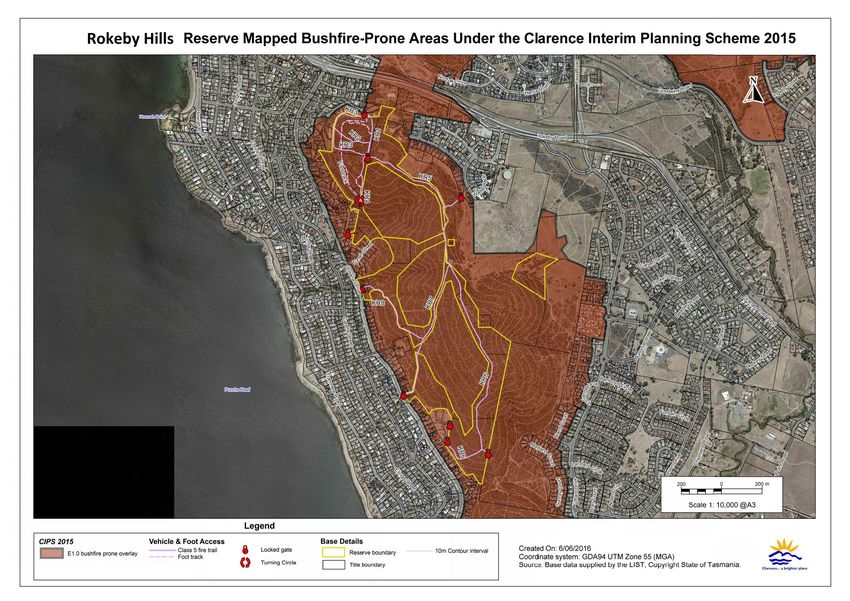
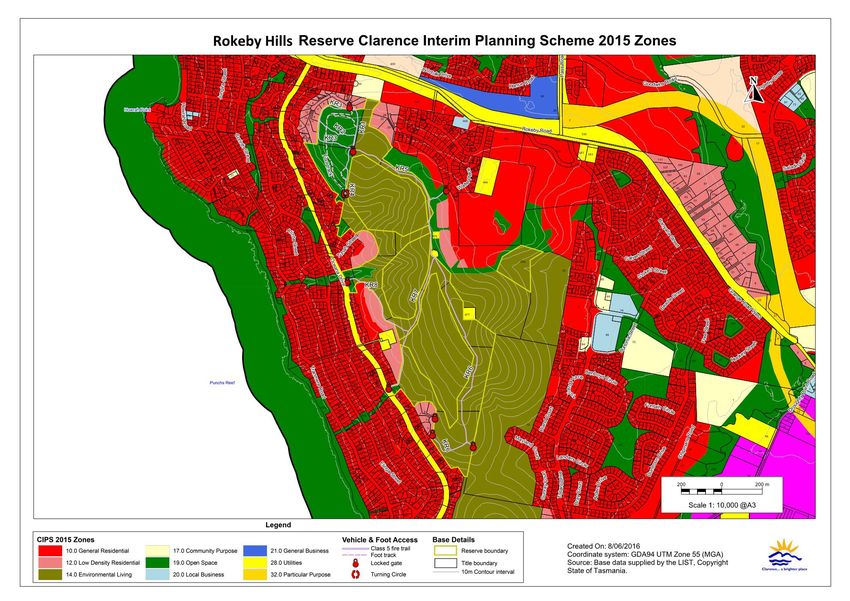
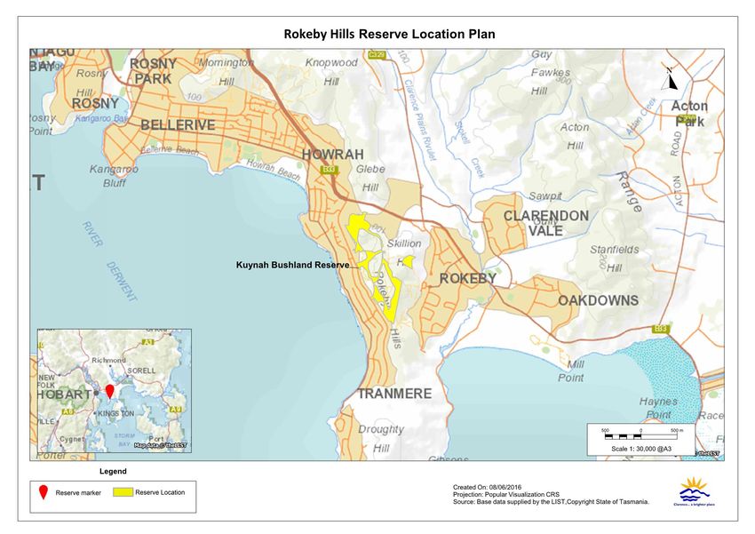
Rokeby Hills Reserve Bushfire Management Plan                                         Revision 2, January 2017

1.2             Location and Description
With the 2016 acquired land, Rokeby Hills Reserve covers an area of approximately 40ha. The
reserve is located along the skyline of Rokeby Hills, bordering the suburbs of Howrah and Rokeby
(figure 1). The highest point in the reserve is approximately 150m above sea level (ASL) with a
north to westerly aspect. The reserve is surrounded by residential developments to the north,
south and west and bushland/grasslands on private property and residential developments to the
east. Four large privately owned blocks are scattered throughout Rokeby Hills surrounded by the
reserve and are zoned as Environmental Living under the Tasmanian Interim Planning Scheme
Zoning (figure 2). The reserve has multiple entry points; access from the eastern boundary is via
bushland/degenerated pasture on private property exiting Rokeby which has multiple
unrestricted entry points. This creates challenge as allows for the frequent dumping/torching of
stolen cars, rubbish dumping and illegal fire wood collection. Multiple costly attempts have been
made to restrict access and have not been successful.

The reserve and some adjacent land (figure 4) have been mapped as a bushfireAprone area under
the Clarence Interim Planning Scheme 2015 (CIPS 15). Any future developments within or adjacent
may require a Bushfire Risk Assessment and a Bushfire Hazard Management Plan.

1.2.1        Geology and Soils
Soils in the norther elevated sections of the reserve are shallow dark brown clays of moderate
fertility over Jurassic dolerite and are considered to have a low erodibility. The lower section in the
northern end of the reserve and the POS (formerly owned by Malwood PTY LTD) is
predominantly underlain by Permian mudstone with thin skeletal soils on the upper slopes and
deeper soils confined to the lower slopes (North Barker Ecosystems Services, 2011).

Clarence City Council                                                                                       2
Rokeby Hills Reserve Bushfire Management Plan       Revision 2, January 2017

Figure 1 – Location of the Reserve

                                                .

Clarence City Council                                           3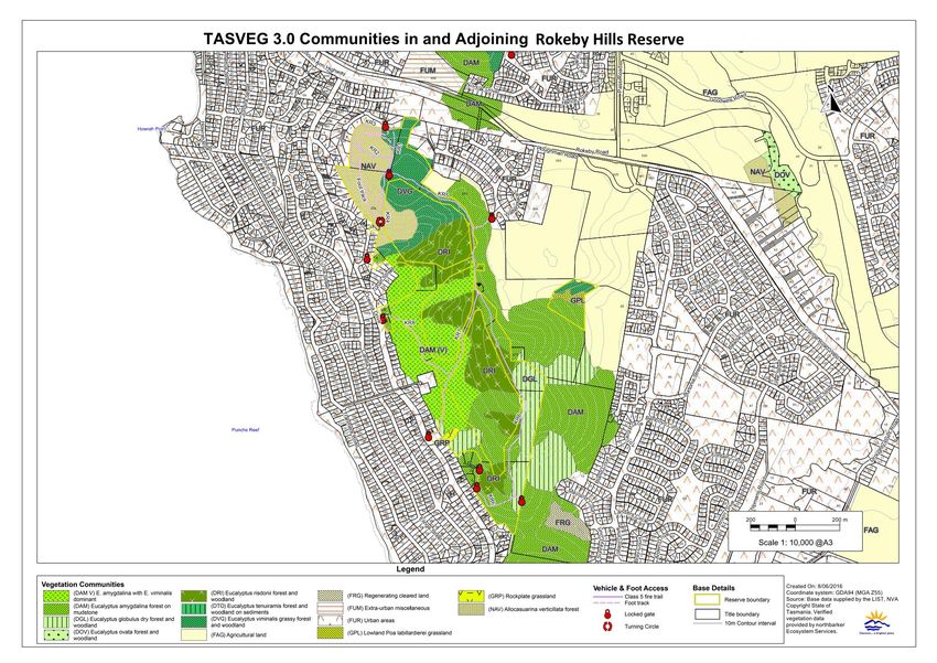
Rokeby Hills Reserve Bushfire Management Plan   Revision 2, January 2017

Figure 2 – Tasmanian Interim Planning Scheme

Clarence City Council                                       4
Rokeby Hills Reserve Bushfire Management Plan                                        Revision 2, January 2017

1.2.2        Vegetation
The major vegetation communities in the reserve are shown in figure 3. Vegetation types and
community boundaries within the reserve is based on Tasveg 3.0 mapping, checked and modified
where required following a survey of the reserve. Vegetation community boundaries outside the
reserve have not been checked for accuracy but are shown to give an indication of the surrounding
vegetation. Vegetation communities within the reserve are:

Eucalyptus amygdalina with Eucalyptus viminalis dominant (DAM V)

Eucalyptus amygdalina forest and woodland on mudstone (DAM)

Eucalyptus globulus dry forest and woodland (DGL)

Eucalyptus risdonii forest and woodland (DRI)

Eucalyptus viminalis grassy forest and woodland (DVG)

Agricultural land (FAG)

Lowland Poa labillardierei grassland (GPL)

Rockplate grassland (GRP)

Allocasuarina verticillata forest (NAV)

The reserve has a grassy understorey with some sections of relatively dense, shrubby understorey.
Ground cover is suppressed in some of the northern NAV section where she oak is dense.

Areas within the Lowland Poa labillardierei grassland (GPL) are listed as critically endangered
under the Commonwealth Environment Protection and Biodiversity Conservation Act 1999; however it
has not been determined whether the areas of GPL on the land qualify as constituting the listed
community. The community is ‘derived’ from past removal of canopy Eucalyptus viminalis.
Removal of introduced livestock in recent years has led to an overAmature grassland dominated by
large, rank tussocks of Poa labillardierei, with notably occurrences of weed species such as Bria rose
(Rosa rubiginosa) (North Barker Ecosystems Services, 2010).

Rockplate grassland (GRP) is an example of a vegetation type which may be similar to, intergrade
with, or occur close to the lowland native grasslands of Tasmania. These vegetation types are
excluded from the national ecological community in their own right. However, where a patch of
vegetation meets the description and the condition thresholds of the lowland native grasslands of
Tasmania presented in the listing advice then it forms part of the listed national ecological
community (Department of the Environment, Water, Heritage and the Arts, 2010).

Eucalyptus globulus dry forest and woodland (DGL) and Eucalyptus risdonii forest and woodland
(DRI) are listed as threatened native vegetation communities under the Nature Conservation Act
2002.

Clarence City Council                                                                                      5
Rokeby Hills Reserve Bushfire Management Plan                                        Revision 2, January 2017

1.2.3        Reserve Usage
The reserve is a locally important recreational area for activities such as; mountain biking, walking,
dog exercising and jogging.

The reserve is accessible by 4WD vehicles (and stolen 2WD vehicles) from the east with frequent
torching of stolen vehicles. There is also evidence of wood hooking and rubbish dumping in the
reserve (localised to eastern boundaries).

Clarence City Council                                                                                      6
Rokeby Hills Reserve Bushfire Management Plan                     Revision 2, January 2017

Figure 3 – Native Vegetation Types in and adjoining the Reserve

Clarence City Council                                                         7
Rokeby Hills Reserve Bushfire Management Plan                                           Revision 2, January 2017

1.3             Bushfire Management Objectives
Bushfire management within the Rokeby Hills Reserve will meet the following broad management
objectives:

1.   Protection of life, assets and adjoining property from bushfire.

2.   Minimise the risk of fires starting and spreading in the reserve.

3.   Protection and enhancement of the ecological and visual values provided by the reserve.

4.   Protection of infrastructure and cultural heritage values within the reserve.

5.   Recovery, maintenance and enhancement of vegetation communities and fauna habitat within
     the reserve.

6.   Minimisation of soil loss resulting from bushfire, or bushfire management activities.

The actions recommended to attain each of these objectives are listed in section 5.1.

Clarence City Council                                                                                         8
Rokeby Hills Reserve Bushfire Management Plan Revision 2, January 2017 Figure 4 – Mapped Bushfire3Prone Areas under the Clarence Interim Planning Scheme 2015 (CIPS 15) Clarence City Council 9
Rokeby Hills Reserve Bushfire Management Plan                                        Revision 2, January 2017

1.4             Reserve Management Responsibilities
Management of the reserve is the responsibility of Clarence City Council. Clarence City Council
has a responsibility under the Fire Service Act (1979) to take all reasonable precautions to prevent
any fire lit on their property from spreading onto neighbouring property. This BMP will help to
fulfil that “duty of care”. The TFS is responsible for suppressing bushfires within the reserve.

1.5              Management Plans
There are a number of assessments and management plans that were prepared for parts of the
reserve or adjoining areas that contain information relevant to the management of the reserve prior
to, and post Councils acquirements of POS during 2016. These include:

A Draft Reserve Activity Plan (RAP) covering the former Kuynah Bushland Reserve BMP
     boundary (8ha). The RAP is intended to document the natural, cultural, recreational and other
     values of the reserve, and include an implementation plan for proposed onAground activities.
     This RAP runs from 2016A2021 and is planned to be amended to incorporate the acquired POS.

A Nature Conservation Plan identifying general management objectives in addition to specific
     management objectives for natural values of land covered under the Conservation Covenant
     (figure 5). This plan is part of the Conservation Covenant under Part 5 of the Nature
     Conservation Act 2002.

A Vegetation Survey and Fauna Habitat Assessment covering approximately 77.4ha comprising of
     the 2016 Council acquired POS, and the remaining privately owned bushland by Malwood
     PTY LTD. This assessment was undertaken in 2011 and designed to ensure the proposed
     development responded sympathetically to the natural values.

1.6             Conservation Covenants
The reserve has one Conservation Covenant in place on the land under Part 5 of the Nature
Conservation Act 2002. The covenant at Rokeby Hills was developed as an offset for impacts
associated with adjacent residential development. The covenant meets a threatened species permit
condition imposed by the Development and Conservation Assessment Branch, Department of
Primary Industries, Parks, Water and Environment (DPIPWE) that requires a perpetual
Conservation Covenant to be registered upon the land title.

The land provides an important area of native vegetation in Hobart’s periAurban zone and
provides an opportunity to protect threatened species and communities, whilst contributing to a
potential native vegetation corridor between the Rokeby Hills and the Howrah Hills to the north
(North Barker Ecosystems Services, 2010).

The lands placed under these covenants by the previous owners are shown in figure 5.

Clarence City Council                                                                                     10
Rokeby Hills Reserve Bushfire Management Plan Revision 2, January 2017
The Conservation Covenants binds the current and all future owners of the land. The sections in
the Terms of Covenant that have implications for bushfire management in the reserve are:
Clause 4.2 (c) “introduction of Foreign Material {must not be undertaken} except materials for the
maintenance and construction of infrastructure, fences or carriageways as
authorised in writing by the Minister”
Clause 4.2 (d) “offAroad use of vehicles except for emergency purposes, or for the purpose of
assisting the maintenance or construction of fences, carriageways or infrastructure”
Clause 4.2 (f) “lighting of fires {must not be undertaken} except for the purpose of fire hazard
reduction or management of the Natural Values as authorised in writing by the
Minister”
Clause 4.2 (h) “use of herbicides and other chemicals {must not be undertaken} except for
registered herbicides or pesticides for the purpose of controlling exotic species that
threaten natural values”
Clause 4.2 (i) “removal or disturbance of soil, rock or other mineral resources {must not be
undertaken} except for the purposes of maintenance and construction of fences,
carriageways, including walking tracks or infrastructure and for revegetation
activities”
Clause 4.2 (k) “building or placement of infrastructure, fences or carriageways {must not be
undertaken} except:
(i) for the purposes of fencing to protect the Land from activities on adjoining
land or to meet property boundary fencing commitments to adjoining
landowners”
(ii) for the purposes of constructing additional fences or constructing
additional carriageways as authorised in writing by the Minister;
Clause 4.2 (m) “clearance of native vegetation {must not be undertaken} except:
(i) for the purposes of fire hazard reduction, firefighting purposes, or the creation
and maintenance of firebreaks if authorised by the Tasmanian Fire Service or as
authorised in writing by the Minister;
(ii) for the purposes of maintenance of carriageways, rights of ways and easements
in accordance with all Legislative Requirements;
(iii) for the purposes of constructing carriageways additional fences or infrastructure
as authorised in writing by the Minister;
(iv) for the purposes of maintenance of fences, carriageways or infrastructure as
authorised in writing by the Minister;
(v) for the purpose of management of the Natural Values through the planned use
of fire as authorised in writing by the Minister”
Clarence City Council 11Rokeby Hills Reserve Bushfire Management Plan Revision 2, January 2017
Clause 4.3 “The Owner agrees:
(a) to use best endeavours to ensure that Exotic Species that threaten the Natural
Values of the Land do not become established;
(b) to use best endeavours to eliminate or control established Exotic Species that
threaten the Natural Values of the Land by observing the weed management
prescriptions and feral animal control prescriptions issued for the Land by the
Minister;
(c) to observe any reasonable fire management practices prescribed for the Land by
the Minister;
(d) to maintain fences if those fences are necessary to protect the Natural Values of
the Land;
(e) to observe any threatened species management prescriptions issued for the Land
by the Minister;
(f) to observe any prescriptions limiting offAroad vehicle use issued for the Land by
the Minister; and
(g) to use best endeavours to protect the Natural Values of the Land.
Clause 9 “The Owner will advise the Minister of any proposed actions or events which have had,
or may have, adverse effects upon the Natural Values”
These restrictions only apply to the portions of the reserve covered by the Conservation Covenants.
There are other provisions in the Covenants that will affect other management activities.
As required under the terms of the Covenant, Council's Fire and Bushland Management will seek
Ministerial authorisation from the Department of Primary Industries, Parks, Water and
Environment (DPIPWE) to use fire prior to implementation of this Plan. If sufficient detail is
provided to DPIPWE in the BMP then the authorisation may be provided for the full 5 year life of
the Plan.
Clarence City Council 12Rokeby Hills Reserve Bushfire Management Plan Revision 2, January 2017 Figure 5 – Extent of Conservation Covenant Clarence City Council 13
Rokeby Hills Reserve Bushfire Management Plan                                           Revision 2, January 2017

2.         Bushfire Risks
Extreme bushfire conditions can occur in southern Tasmania when dry winters and springs are
followed by summers where fuels are very dry. Under these conditions, fires can be expected to
move quickly under the influence of strong, dry, northAwesterly winds, and then move more or
less at right angles on a broad front when the subsequent southAwesterly wind change arrives.
Fires that start under these conditions can reach a very high intensity, even in areas with relatively
low fuel loads, and are very difficult to control until the weather conditions abate.

2.1             Bushfire History and Causes
The 1967–2015 bushfire history and 2011A2016 TFS incidents within the reserve are shown on figure
6.

2.1.1        Bushfires
Data supplied by the TFS and Clarence City Council showed that within the period 2011 to 2016
the TFS attended eight vegetation fires 1ha within the reserve. During
January 2013 a vegetation fire impacted approximately 2ha within the Council managed bushland
behind Maum Street, Rokeby followed by an additional 7ha in February 2013 at the same location.
All ten incidents were determined as malicious

The previous BMP stated during 1997 a vegetation fire impacted approximately 10ha within the
reserve adjacent to Caroda Court and Fairisle Terrace; however there are no records of this fire. It is
believed the fire originated from an escaped burn off on private property.

There have also been nine recorded torched vehicles on the eastern side of the reserve, however
this figure is considered to be grossly under inflated. During field visits for the BMP review
approximately 30 torched cars were observed.

2.1.2        Planne d Burning
During the 5 year period covered by the previous BMP, Clarence City Council conducted two
planned burns within the reserve (figure 7). VMU 2 was broadscale burnt during 2011,
considerable boneseed (Chrysanthemoides monilifera) germinated post burn and an extensive post
burn weed management program was enacted. This infestation has now been controlled and
annual monitoring occurs. VMU 5 was scheduled to be broadscale burnt during 2013.
Unfavourable conditions prevented the scheduled burn in 2013. The burn was carried over to 2014
where sections were heap burnt with the reminder broadscale burnt during 2015.

The revised planned burning schedule for 2016A2021 can be found in Table 8.

Clarence City Council                                                                                        14
Rokeby Hills Reserve Bushfire Management Plan                                                       Revision 2, January 2017

Figure 6 – Reserve Bushfire History (1967–2015) and attended TFS Incidents of Reserve (201132016)

Clarence City Council                                                                                           15
Rokeby Hills Reserve Bushfire Management Plan   Revision 2, January 2017

Figure 7 – Planned Burn History (201132015)

Clarence City Council                                       16
Rokeby Hills Reserve Bushfire Management Plan                                           Revision 2, January 2017

2.2             Fuel Types and Hazard Levels
The higher the intensity of a bushfire the greater its destructiveness and the more difficult it is to
control. As the intensity of a bushfire increases it becomes progressively more difficult to contain
and suppress the bushfire. Very high intensity (> 4000 kW/m heat output at the fire front) fires
with flame heights greater than 10m are generally uncontrollable (NSW Rural Fire Service, 1997).
Although grass fires rarely attain a very high intensity, they can move much faster than forest fires,
thereby making them difficult to contain.

Fire intensity is a function of the heat content of the fuel, the quantity (load) of fuel, and the rate of
spread of the bushfire. The heat content of vegetation fuels is roughly constant, and rate of spread
is largely a function of slope and weather conditions (wind speed and relative humidity). It has
been found that the quantity and distribution of fine fuels are the main factor influencing bushfire
behaviour. Larger fuels burn during a bushfire but do not contribute significantly to the spread of
a bushfire (NSW Rural Fire Service, 1997).

Fine fuels consist of dead plant matter less than 6mm in diameter and live plant matter less than
2mm in diameter (including grasses, bracken, leaves, bark, and twigs and branches) (MarsdenA
Smedley, 2009). Fine fuel load (measured in tonnes per hectare) has therefore been used as a
convenient measure of the underlying bushfire hazard in areas dominated by woody vegetation.
The fine fuel load at any given time is a balance between the rate of fuel buildAup, and factors that
remove fuel, such as litter decomposition and fire. In the absence of bushfire, fuel loads in forests
and woodlands with a shrubby or heathy understorey build up to a quasiAequilibrium state where
the rate of fuel production equals the rate of decomposition.          The maximum levels vary for
different vegetation types and also for the same vegetation types in different locations (Conroy,
1988). The time taken to reach equilibrium fuel loads also varies, ranging from about 2 years in
some native grasslands to about 20 to 40 years in dry eucalypt forests (MarsdenASmedley, 2009).

However, it has been found that the fuel structure is possibly more important than the total fine
fuel load in determining bushfire behaviour (MardenASmedley, 2009). Fuel in forests, woodlands
and shrublands can be categorised into four layers with differing effects on bushfire behaviour
(Hines et al., 2010). These layers are:

•    Surface fine fuel; leaves, bark, small twigs and other fine fuel lying on the ground. These
     fuels provide the horizontal continuity that allows a bushfire to spread.

•    Near surface fine fuel; grasses, low shrubs, bracken etc. up to about 0.5m above the ground
     surface. Fuels in this layer will burn when the surface fuel layer burns and will increase
     bushfire intensity.

Clarence City Council                                                                                        17
Rokeby Hills Reserve Bushfire Management Plan Revision 2, January 2017
• Elevated fuels; larger shrubs and small saplings with most of the fuel closer to the top of this
layer and a clear gap between them and the surface fuels. These interact with the two lower
fuel layers to further increase bushfire intensity. They also contribute to the vertical continuity
of fuel that allows fire to ‘climb’ into the tree canopy.
• Bark fuels; flammable bark on trees, saplings and large bushes from ground level to the
canopy. Loose fibrous bark on stringyAbark eucalypts, and candle bark on some gums can
generate large amounts of burning embers which can start spot fires ahead of the main fire
front.
Canopy fuels are not usually included in fuel hazard assessments in forests and woodlands, but
are included in shrubland and heath fuel types where they are equivalent to elevated fuels. If there
is sufficient fuel in the lower fuel layers to start the canopy fuel burning (called a crown fire) fire
intensity can increase considerably. Crown fires in forests are generally considered uncontrollable
(Luke and McArthur, 1986).
The main fuel factor that influences the rate of spread of a bushfire is the quantity of near surface
fuel whereas total fine fuel load is the main factor influencing fire intensity (Gould et al 2007).
In grasslands and grassy woodlands the degree of curing (dryness) of the fuel is considered at least
as important as the actual fuel load (Cheney and Sullivan, 2008). Grass goes through an annual
cycle with new growth in spring drying out over summer. The bushfire hazard in grassland areas
is greatest when the grass is fully cured which usually occurs during the period from December to
April depending on seasonal breaks and significant summer rainfall events. However, grasslands
that are not grazed or slashed over winter can burn in spring if cured grass from the previous
growing season is still present.
Unlike bushland dominated by woody plants, grasslands can accumulate fuel very rapidly, and
therefore burning is not a very effective method of hazard reduction. As grass fuel decomposes
faster than eucalypt leaves and twigs, and is more likely to be eaten by herbivores, fuel loads in
grasslands and grassy woodlands can fluctuate from year to year (Cheney and Sullivan, 2008).
Fuel loads can be roughly categorised in terms of the potential threat they pose as follows:
Low A < 5 tonnes per hectare
Moderate A 5 to 15 tonnes per hectare
High A >15 tonnes per hectare.
The characteristics of each fuel type in the reserves is given in table 1. The TASVEG 3.0 codes of
the vegetation types in figure 3 corresponding to each fuel type are listed under the fuel type.
Clarence City Council 18Rokeby Hills Reserve Bushfire Management Plan Revision 2, January 2017
Table 1 – Characteristics of the different fuel types in the reserves
FUEL TYPE FUEL HAZARD
BUSHFIRE BEHAVIOUR AND CONTROL
CHARACTERISTICS
Grassy Canopy, surface, near surface, Can burn with moderate to high intensity depending
forest / elevated and bark fuels present. on the degree of fuel buildAup. Significant ember
woodland Surface fuels are dominant fuel layer attack on structures and spotting across containment
DAM in the form of bark, sticks and dead lines can be expected. Capable of carrying a bushfire
branches. Near surface fuels sparse at any time of year if there is a sufficient amount of
DAM (V)
with some dense aggregates in the litter on the ground, and/or cured grass.
DRI1
form of grasses up to 0.1m. Elevated Tree cover generally to sparse to sustain crown fire.
DVG fuels also sparse within DRI, but can Eucalypt component with hollows and rough bark
be dense in other communities. will be a source of burning embers which can carry a
LowAmoderate fuel loading. bushfire over nearby fire control lines (roads, fuel
breaks) and threaten nearby assets.
Grass component of the fuel load can
build up rapidly after fire. Fuel reduction burning is effective in removing
accumulated litter and the bark fuels largely
responsible for spotting, but grass fuels can be
replenished within a year after a burn.
Shrubby Canopy, surface, elevated and bark Can burn with moderate to high intensity depending
forest / fuels present. Near surface fuels on the degree of fuel accumulation. Significant ember
woodland present but sparse in locations. Where attack on structures downwind of the bushfire and
DGL1 she oak present duff layer averages spotting across containment lines can be expected.
10A20mm, mainly she oak needles. Capable of carrying a bushfire at any time of year if
Shrub layer 3A5m in height. Near there is a sufficient amount of litter on the ground.
surface fuels a mixture of grasses, Tree cover generally to sparse to sustain crown fire.
leaves and bark. Leaf and bark fall Eucalypt component with hollows and rough bark
around trees contributes to a gradual will be a source of burning embers which can carry a
buildAup of fuel, particularly around bushfire over nearby fire control lines (roads, fuel
the base of trees. Generally moderate breaks) and threaten nearby assets. Fuel reduction
overall fuel load. Grass component of burning is effective in removing accumulated litter,
the fuel load can build up rapidly however limited near surface fuels can limit rate of
after fire. spread of fire during planned burns.
Unmanaged Native and introduced grasses, near Can generate rapidly moving, moderate intensity
grassland surface and surface fuels present. fires in late summer and early autumn. Fires can
GPL2 Potential for dense elevated fuels to occur at other times of the year if the cured standing
about 1m high following wet winters crop from the previous year’s growth persists. Likely
GRP
and springs. Flammability dependant to be relatively little spotting so fires can usually be
on degree of curing of the grass. stopped at roads and firebreaks, however, fires may
Grass fuels can be replenished within be uncontrollable in severe fire danger rating (FDR)
a year after a burn. conditions.
Shrubland Moderate overall fuel loads, Where shrub canopies touch the fuel can sustain a
NAV predominantly elevated and bark running crown fire of high intensity that would be
fuels. High proportion of the fuel difficult to control. Dense thickets are difficult to
finely divided and elevated up to 6A access. Significant ember attack on nearby structures
7m. Relatively low surface and near and spotting across containment lines can be
surface fuel loads except where the expected. May be difficult to burn at low intensity in
shrub cover is sparse. Thick duff layer cool weather due to low surface and near surface fuel
up to 40A50mm in form of she oak loads.
needles.
1 Nature Conservation Act 2002.
2 Environment Protection and Biodiversity Conservation Act 1999.
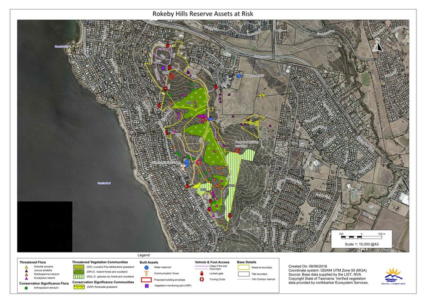
Clarence City Council 19Rokeby Hills Reserve Bushfire Management Plan Revision 2, January 2017 General fuel loadings throughout the reserve are moderate averaging 10t/ha. Fuel characteristics are noticeably different amongst exposed DRI community, being more open and dry with limited understorey. Fire suppression amongst DRI community must factor in localised very shallow soils on bedrock. The eastern side of the reserve experiences frequent localised fires due to the torching of stolen cars. These fires have previously assisted in maintaining a mosaic of ridgeline fires, with lowA moderate fuel loadings. The vast extent of inAformalised fire wood cutting tracks assists in suppressing fires within the reserve. 2.3 Bushfire Threat and Risk to Persons The reserve is situated amongst approximately 110ha of undeveloped privately owned bushland and Council managed POS. The main bushfire threat to the reserve is considered to come from fires originating or entering the reserve from the northern end or western slopes that can travel fast running the length of the reserve, and has potential to reach high intensity under days of strong, dry prevailing north to norAwesterly winds. Such fires could quickly run the length of the reserve and threaten adjoining property or life of those situated within. In addition, fires starting within the southern section of the reserve have potential to be fanned through the reserve by afternoon south west to south easterly sea breezes. Constructing future dwellings/assets within or adjacent to the reserve to the Australian Standard 3959A2009 Construction of buildings in bushfire-prone areas can assist in mitigating impacts by fire. 2.4 Assets at Risk from Bushfire Assets potentially at risk from bushfire include; dwellings, infrastructure, and other items (such as ornamental and regeneration plantings) which would cost money to replace; as well as items of scenic, cultural and natural heritage value which could be damaged or destroyed by bushfire, or bushfire suppression activities. Each landowner has an obligation to reduce a bushfire hazard where it is a threat to neighbouring properties. However, even with extensive hazard reduction treatments, the risk of high intensity bushfires occurring in the reserve cannot be eliminated. Therefore consideration must be given to protection measures that will reduce the risk of bushfire damage to assets in and surrounding the reserves. Assets within and surrounding the reserves that are considered at risk from bushfires are shown in figure 8. Clarence City Council 20
Rokeby Hills Reserve Bushfire Management Plan   Revision 2, January 2017

Figure 8 3 Assets at risk from bushfire

Clarence City Council                                       21
Rokeby Hills Reserve Bushfire Management Plan                                                Revision 2, January 2017

2.4.1        Bushfire Risk to Natural Heritage Assets

The conservation value of the plant communities in the reserve is given in table 2. A number of
plant species of conservation value occur within the reserve. These are listed in table 3 along with
their response to fire if known.

The Natural Values Atlas identifies no verified records of fauna species of conservation significance
occurring within the reserve. It does identify potential habitat present within the reserve for the
following species:

Australian grayling (Prototroctes marena), chaostola skipper (Antipoda chaostola), eastern barred
bandicoot (Perameles gunnii), fortyAspotted paradalote (Paradalotus quadragintus), green and gold
frog (Litoria raniformis), grey goshawk (Accipiter novaehollandiae), masked owl (Tyto novaehollandiae),
spottedAtail quoll (Dasyurus maculatus), swift parrot (Lathamus discolor), Tasmanian devil
(Sarcophilus harrisii), Tasmanian wedgeAtailed eagle (Aquila audax subsp. Fleayi), Tunbridge looper
moth (Chrysolarentia decisaria), tussock skink (Pseudemoia pagenstecheri), WedgeAtailed eagle (Aquila
audax) and WhiteAbellied seaAeagle (Accipiter novaehollandiae).

Table 2 – Conservation value of native plant communities
    TASVEG 3.0                 EQUIVALENT FLORISTIC
                                                                 Conservation Status2     EPBC STATUS3
        CODE                       COMMUNITY1

        DAM                          DRYAgAMmud
                                                                    Not threatened          Not threatened
      DAM (V)                   Grassy E. amygdalina forest

                                      DRYAgGLOB                  THREATENED NATIVE
         DGL                                                                                Not threatened
                                 Grassy E. globulus forest          COMMUNITY
                                        DRYAgRIS                 THREATENED NATIVE
         DRI                                                                                Not threatened
                                  Grassy E. risdonii forest         COMMUNITY
                                      DRYAgVIM
         DVG                                                        Not threatened          Not threatened
                              Grassy E viminalis woodland
         GPL                           None described               Not threatened      Critically endangered
                                                                                        Treat as critically
                                                                                        endangered when
                                                                                        vegetation meets the
         GRP                           None described               Not threatened      description and the
                                                                                        condition thresholds of
                                                                                        the Lowland Native
                                                                                        Grasslands.
                                     DRYAin VERT
         NAV                                                        Not threatened          Not threatened
                             Inland A. verticillata low forest
1. Forest Practices Authority (2005)
2. Nature Conservation Act 2002
3. Environment Protection and Biodiversity Conservation Act 1999

Clarence City Council                                                                                             22
Rokeby Hills Reserve Bushfire Management Plan Revision 2, January 2017
Table 3 A Plant species of conservation value and preferred bushfire management
ENVIRONMENT
PROTECTION AND
CONSERVATION RESPONSE TO BUSHFIRE AND
SPECIES OCCURRENCE BIODIVERSITY
STATUS1 MANAGEMENT
CONSERVATION ACT 1999
(EPBC Act) STATUS
Delisted as RARE1
Arthropodium Noticeable flush of regeneration from
in 2015. Holds Four observations on lower
strictum seed following fire. Plants also Not threatened
conservation section above Oceana Drive.
chocolate lily regenerate from tuberous rootstock.
significance.
Regenerates from lignotubers.
Eucalyptus risdonii Localised communities on
Repeated fires may weaken trees. Fire
Risdon RARE western facing slopes (figure Not threatened
promotes seed release and subsequent
peppermint 8).
germination.
Juncus amabilis Localised occurrences in areas Most likely pollination vector is wind.
RARE Not threatened
gentle rush with impeded drainage. Species is reported to persist after fire.
Ranunculus
Delisted as RARE1
sessiliflorus var. Previously recorded in
in 2015. Holds
sessiliflorus vegetation Management unit Regenerates from seed. Not threatened
conservation
shade (VMU) 3 & 4 (figure 10).
significance.
peppercress
Rytidosperma
Localised occurrences in open Likely to regenerate from rootstock
indutum RARE Not threatened
dry sclerophyll woodlands. and establish from seed after bushfire.
tall wallaby grass
1 Tasmanian Threatened Species Protection Act 1995
Clarence City Council 23Rokeby Hills Reserve Bushfire Management Plan Revision 2, January 2017
The fire sensitivity and flammability ratings of the vegetation types in the reserves according to
Pyrke and MarsdenASmedley (2005), is given in table 4.
Table 4 – Fire attributes of the native vegetation
TASVEG 3.0 CODE FIRE SENSITIVITY FLAMMABILITY
DAM
Low High
DAM (V)
DGL Low High
DRI Low High
DVG Low High
GPL Low High
GRP Low High
NAV Low Moderate
Flammability classification of Tasmanian vegetation (Pyrke & MarsdenASmedley, 2005)
FLAMMABILITY CRITERIA FOR FLAMMABILITY
Will burn readily throughout the year even under mild weather conditions, except
Very high after recent rain (i.e. less than 2–7 days ago).
Will burn readily when fuels are dry enough but will be too moist to burn for lengthy
High periods, particularly in winter. Fuels will be dry enough to burn on most days from
late spring to early autumn.
Extended periods without rain (i.e. two weeks at least) and/or moderate or stronger
Moderate winds are required for these communities to burn.
These communities will burn only after extended drought (i.e. four weeks without
Low rain) and/or under severe fire weather conditions (i.e. forest fire danger index > 40).
Note: recently burnt stands of low or moderate flammability classes may have a higher flammability rating.
Clarence City Council 24Rokeby Hills Reserve Bushfire Management Plan Revision 2, January 2017
Fire sensitivity classification of Tasmanian vegetation (Pyrke & MarsdenASmedley, 2005)
FIRE MANAGEMENT
ECOLOGICAL IMPACT OF BUSHFIRE
SENSITIVITY RECOMMENDATIONS
Extreme Any bushfire will cause either irreversible or very Suppress all bushfire. Highest
longAterm (> 500 years) damage. priority for bushfire suppression.
Very high A single bushfire will cause significant change to Suppress all bushfire. High
the community for 50–100 years and will increase priority for bushfire suppression.
the probability of subsequent fires changing the
community permanently.
High A fireAadapted community requiring at least 30 Suppress all bushfire, but give
years between fires to maintain the defining species. higher priority to stands burnt less
Bushfire intervals greater than 80 years are required than 80 years ago.
to reach mature stand structure.
Moderate A fireAadapted community requiring at least 15 Suppress fires in stands burnt less
years between fires to maintain the defining species. than 20 years ago.
Low Highly fireAadapted or nonAnative vegetation. A Suppression usually not an
single bushfire will generally not affect biodiversity, ecological priority except in specific
although repeated short intervals (i.e. < 10 years) situations (e.g. a recently burnt
may cause longA term changes. stand of a threatened species).
The low fire sensitivity of the native vegetation in the reserves indicates that it is highly fire
adapted and a single fire will generally not adversely affect biodiversity, though repeated fires at
intervals of less than 10 years may cause longAterm changes in floristics and vegetation structure
(Pyrke & MarsdenASmedley 2005). The moderate to high flammability rating of the native
bushland in the reserves in Pyrke & MarsdenASmedley (2005) indicates that the bushland in the
reserves will burn readily when fuels are dry but may be too moist to burn for long periods during
winter. Fuels will generally be dry enough to burn on most days from late spring to early autumn.
2.4.2 Bushfire and Habitat Management
The main bushfire risk to natural heritage assets in the reserve is from bushfires that burn the
whole of the reserve as well as bushfire regimes (planned or unplanned) that are outside the
thresholds within which a particular plant community, or habitat for flora and fauna species, has
viability in the longAterm. Bushfire regimes within the thresholds of a particular plant community
will help maintain its longAterm viability, whereas bushfire regimes outside the thresholds are
likely to lead to progressive changes in the structure and floristics of the plant community, and loss
of habitat for the fauna favouring that plant community.
High intensity bushfires that burn the whole of the reserve can damage or destroy valuable fauna
habitat including:
• Tree hollows used as nests and dens by many birds and arboreal mammals.
• Mature, senescing or dead trees that can be important invertebrate, bird and reptile habitat,
and take a long time to replace.
• Understorey species that provide nest and shelter sites as well as a food source for many bird
and mammal species.
Clarence City Council 25Rokeby Hills Reserve Bushfire Management Plan Revision 2, January 2017
• Fallen logs, bark and leaf litter that provide shelter and a food source for invertebrates, frogs,
reptiles, birds and mammals.
Species may be lost from the reserves if they cannot recolonise from nearby areas, or survive in
unburnt patches.
Bushfires often stimulate the spread of environmental and other weeds. However, some weed
species provide significant protection and food sources for fauna (for example, gorse and
blackberry) and removal of these species should be carefully managed to ensure they are
progressively replaced by equivalent native species habitat.
Planned burning of the native vegetation in the reserve at the optimum frequency for its longAterm
viability is considered the best way to conserve important habitat for both flora and fauna in the
reserve. Planned burning in a mosaic pattern along with maintenance of fire trails is the best way
to minimise the risk of a bushfire burning the whole of the reserves. The bushfire management
requirements of the different plant communities/habitats in the reserves are given in table 5.
These plant communities have been grouped together according to their bushfire management
requirements.
Clarence City Council 26Rokeby Hills Reserve Bushfire Management Plan Revision 2, January 2017
Table 5 3 Bushfire management requirements of the plant communities in the reserves
TASVEG 3.0 MAPPING UNITS BUSHFIRE IMPACTS AND BUSHFIRE MANAGEMENT AIMS
Grassy dry sclerophyll forests and woodlands
DAM –Eucalyptus amygdalina forest Infrequently burnt sites develop a dense shrubby understorey. Kangaroo grass (Themeda triandra) can die out after an
on mudstone extended absence of bushfire, or other method of biomass reduction (Lunt & Morgan, 1998).
DAM (V) A Eucalyptus amygdalina Frequent fires (< 5 years) can inhibit tree regeneration and eliminate the shrubby component.
with Eucalyptus viminalis dominant Sites overlying dolerite and other more fertile soils have markedly more rapid rates of regeneration than low fertility
soils derived from mudstone and sandstone.
DGL A Eucalyptus globulus dry forest
Overfrequent burning regimes in the past within much of the forest overlying mudstones around Hobart has
and woodland contributed to loss of topsoil and erosion.
DRI A Eucalyptus risdonii forest and Extended absence from bushfire can result in buildAup of fuel causing hot and damaging burns.
woodland A temporal and spatial mosaicAburning pattern would assist with tempering the effects of a devastating bushfire.
DVG – Eucalyptus viminalis grassy Optimal bushfire frequency is 5320 years on fertile sites.
forest and woodland Exclude bushfire from representative areas to provide controls for monitoring the effects of bushfire. Exclude
bushfire from most areas on mudstone, which due to low fertility have low biomass growth rates and are drought
stressed.
Non eucalypt forests/woodlands
NAV – Allocasuarina verticillata Extended absence of fires leads to a closed canopy and a dense litter layer that has a low density and diversity of
Forest ground layer species, although it may be important for invertebrate species.
Frequent low intensity fires benefit Allocasuarina verticillata over the adjacent eucalypt dominated communities
(Kirkpatrick 1985).
Tendency to exclude bushfire for visual impact reasons in foreshore environments risks the longAterm loss of
regenerative age classes and the ultimate decline of this community in favour of grassland. Alternate methods of
facilitating natural regeneration through localised clearance may be a more suitable method.
Preferred bushfire interval in inland reserves is between 15325 years.
Clarence City Council 27Rokeby Hills Reserve Bushfire Management Plan Revision 2, January 2017
TASVEG 3.0 MAPPING UNITS BUSHFIRE IMPACTS AND BUSHFIRE MANAGEMENT AIMS
Grasslands
GPL A Lowland Poa labillardierei Bushfire intervals > 5 years may lead to a loss of biodiversity in grassy sites (Lunt & Morgan, 1988).
grassland Frequent fires (< 5 year intervals) may lead to a loss in diversity of invertebrates.
GRP – Rockplate grassland Grasslands are very localised. Some burning or other biomass reduction may be necessary to maintain them in the
long term if bushfire is excluded.
Clarence City Council 28Rokeby Hills Reserve Bushfire Management Plan Revision 2, January 2017 2.4.3 Bushfire Risk to Built and Cultural Asse ts During the BMP review process Aboriginal Heritage Tasmania (AHT) completed a requested search of the Aboriginal Heritage Register (AHR) regarding the area inside the BMP boundary. There are no known Aboriginal heritage sites within the reserve. There are no built assets within the reserve likely to be at risk from bushfire. The western boundaries above Oceana Drive have some timber paling fences on steel supports. It is generally considered more costly to provide bushfire protection than to replace these fences if impacted by bushfire. External to the reserve on the western boundary is a telecommunications tower and two TasWater reservoirs, to the north east and east are two more TasWaters reservoirs (all roofed), and to the north are two vineyards; Clarence House Vineyard and Meehan’s Vineyard. Although not likely to be directly affected by bushfire or planned burning within the reserve, the grape vines in the vineyards could be affected by smoke from fires. Smoke during the period when the grapes are ripening can taint the wine produced from them and reduce its value. See table 6, table 8 and section 3.1.2 for proposed management strategies for adjacent vineyards. As at May 2016, many dwellings on properties adjoining the reserve are close to the reserve boundary, however the risk to these is reduced by the fact that they are all downslope of the reserve and the winds on days of severe bushfire weather would tend to blow fires to the southA east or east, away from the houses adjoining the reserves. In addition some defendable spaces are maintained annually by Councils Fire and Bushland Management with establishment of additional defendable spaces recommended (see figure 10, table 6 & section 3.1.6). Three of the four bushland blocks adjacent to the POS within Rokeby Hills (figure 8) will have an increased risk from bushfire given the slope under the vegetation which most influences the bushfire attack is downslope. Development of all blocks will require a Bushfire Risk Assessment and a Bushfire Hazard Management Plan and construction to Australian Standard 3959A2009 Construction of buildings in bushfire-prone areas. The degree of bushfire danger at any particular time is a combination of fine fuel quantity, slope, and the prevailing weather conditions. The actual risk of a bushfire causing damage to an asset is a function the degree of danger, the probability of a bushfire igniting, and any measures taken to prevent the bushfire causing damage. The four major modes of attack by bushfires that can cause damage to assets are: 1. WindAblown burning debris. 2. Radiant heat which can ignite flammable materials ahead of the fire front and shatter glass. 3. Flame contact. 4. Strong winds generated or intensified by the bushfire. Clarence City Council 29
Rokeby Hills Reserve Bushfire Management Plan                                        Revision 2, January 2017

The potential for damage to buildings in the path of large fires burning out of the reserve will
depend largely on:

•    Whether the bushfire will approach upslope or downslope.

•    The quantity and distribution of fuel surrounding the building.

•    Whether they are defended during the bushfire.

•    Their design.
•    if the building was constructed to Australian Standard 3959A2009, Construction of Buildings in
     Bushfire-prone Areas.

•    How well they have been maintained.

The Australian Standard for Construction of buildings in bushfireAprone areas (AS:3959 – 2009)
uses a FDR of 50 to determine the Bushfire Attack Level (BAL) for buildings that need to comply
with the standard. An FDI of 50 is the boundary between Very High and Severe Fire Danger
Rating.

There is insufficient data available to assess the likelihood of a high intensity fire starting in the
reserve; however there is sufficient fine fuel within the reserve and the four adjacent private
bushland blocks within Rokeby Hills to sustain a high intensity fire on days of severe fire danger.

The bushfire risk to the built and cultural heritage assets within and surrounding the reserve has
been assessed using a procedure adapted from the National Emergency Risk Assessment
Guidelines (NEMC, 2010). The assessment process is explained in section 5.4 of Clarence City
Council Bushfire Management Strategy for Council Owned and Controlled Land, and the results and
proposed management strategies are shown in table 6. This assessment process has been analysed
and complies with AS/NZS IOS:31000A2009. Note that the assessment in table 6 only considers the
risk from fires starting in, or passing through the reserve. Some assets may face a greater bushfire
risk from nearby bushfire hazards that are not under the control of Clarence City Council.

Some assets, such as Aboriginal heritage sites, may not be directly damaged by bushfire but may
be damaged by bushfire management and bushfire suppression activities, such as constructing fire
control lines. These risks are noted under “other risks” in table 6 if these assets are found in the
reserve.

Clarence City Council                                                                                  30
You can also read