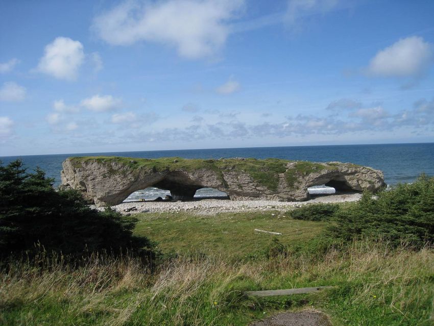
Call for Bids NL09-03, Parcel 1 Western Newfoundland - Regional Setting and Petroleum Geology Evaluation
←
→
Page content transcription
If your browser does not render page correctly, please read the page content below
Call for Bids NL09-03, Parcel 1
            Western Newfoundland
Regional Setting and Petroleum Geology Evaluation

                                              Deer Lake

                         NL09-03

                                              Corner Brook

                               Stephenville

                     Port
                     Aux
                   Basques

                  Natural Resources                          www.gov.nl.ca/nr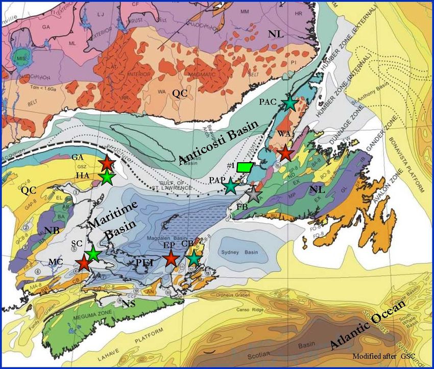
Call for Bids 2009 NL09-03 Western Newfoundland                       Enachescu and Foote
Foreword
This report has been prepared on behalf of the Government of Newfoundland and Labrador
Department of Natural Resources (NL DNR) to provide information on land parcels being
offered in the Canada-Newfoundland and Labrador Offshore Petroleum Board’s (C-NLOPB)
2009 Call for Bids NL09-03. This year the Board has issued three separate Calls for Bids,
including:

   1. Call for Bids NL09-01 (Jeanne d’Arc Basin) consisting of one parcel;
   2. Call for Bids NL09-02 (Laurentian Subbasin) consisting of two parcels, and
   3. Call for Bids NL09-03 (Western Newfoundland and Labrador) consisting of one parcel.

These four parcels comprise a total of 513,769 hectares (1,269,546 acres). All four parcels are
situated on the shelf and deep water off Newfoundland in an area administered by the Canada-
Newfoundland and Labrador Offshore Petroleum Board on behalf of the Province of
Newfoundland and Labrador (NL) and the Federal Government. Newfoundland and Labrador
(NL) is Canada’s easternmost Province that in the past decade has become an important
petroleum producing region. The area also holds large gas discoveries in the Jeanne d’Arc and
Hopedale basins.

Call for Bids NL09-01
Call for Bids NL09-01 consists of a single parcel of 9,558 hectares (23,618 acres), located in 100
m water depth within the Jeanne d’Arc Basin on the Northern Grand Banks. This Mesozoic-
Tertiary basin produced 294,730 bopd from the Hibernia, Terra Nova and White Rose giant oil
fields during the first 6 months of 2009. There are 16 active Exploration Licenses and 45 SDLs
(some covering the same field) in the Jeanne d’Arc Basin and environs. The parcel offered for
bid is located immediately southwest of the White Rose field Production Licence (PL 1007) and
just west of the recent North Amethyst K-15 discovery and Production License (PL 1008). The
Board has previously conducted a Strategic Environmental Assessment in the area covered by
the Call for Bids NL09-01. The bid for this will be concluded on November 19, 2009 at 4 p.m.
NL time. Additional information on this Call for Bids can be found at
http://www.cnlopb.nl.ca/news/pdfs/cfb09_1.pdf

Call for Bids NL09-02
Call for Bids NL09-02 consists of two parcels totaling 364,001 hectares (899,463 acres), located
in the deep water of Laurentian Subbasin, south of the island of Newfoundland. This expansive
Mesozoic-Tertiary basinal area has four large active Exploration Licenses and is on geological
trend with sizable oil and gas discoveries on the Scotian Shelf and Grand Banks of
Newfoundland. With only one exploration well drilled during 2001 in its shelfal part, the
subbasin is practically unexplored. Parcel 1 offered for bid has 290,070 hectares (716,776 acres)
and is located in 500 – 2500 m of water in the south-eastern part of the basin. Parcel 2 offered for
bid has 73,931 hectares (182,687 acres) and is located in 2000– 2600 m of water in the south-
western part of the basin. The Board will conduct a Southern Newfoundland Strategic
Environmental Assessment (2009) prior to the close of Call for Bids NL09-02. The bid for these
parcels will be concluded on November 19, 2009 at 4 p.m. NL time. Additional information on
this Call for Bids can be found at http://www.cnlopb.nl.ca/news/pdfs/cfb09_2.pdf

NL Department of Natural Resources                                                         i
Call for Bids 2009 NL09-03 Western Newfoundland                     Enachescu and Foote
Call for Bids NL09-03
This report focuses on Call for Bids NL09-03 that includes one parcel with an area of 140,210
hectares (346,465 acres) situated within the shallow waters offshore Western Newfoundland
offshore. The Call for Bids NL09-03 parcel is located within a very active Paleozoic exploration
area where a proven petroleum system exists. A large oil flow test was obtained from the Port au
Port #1 well in 1995, while historic oil production, well shows and present day seeps are reported
from the onshore side of the Anticosti Basin. As detailed in this report and earlier publications,
significant oil and gas potential exists in the Parcel offered for bids. The Board has previously
conducted a Strategic Environmental Assessment in the area covered by the Call for Bids NL09-
03. The closing date for Call for Bids NL09-03 (Western Newfoundland and Labrador) is at
4:00 p.m. Newfoundland Standard Time, on November 19, 2009. Additional information on
this Call for Bids can be found at http://www.cnlopb.nl.ca/news/pdfs/cfb09_3.pdf

This report should be referenced as Enachescu, M.E and W. Foote., 2009. Call for Bids NL09-
03, Parcel 1, Regional Setting and Petroleum Geology Evaluation, Government of
Newfoundland and Labrador, Department of Natural Resource and can be downloaded from:
http://www.nr.gov.nl.ca/mines&en/oil/.

We acknowledge the contribution to the writing of this report from Phonse Fagan, Larry Hicks
and Ian Atkinson who earlier summarized the regional geology of the area in reports available
from Newfoundland and Labrador Department of Natural Resources website. Thanks are due to
MUN, PPSC and PR-AC as well as to Landmark-Halliburton, Canstrat and IHS. We also
acknowledge the contribution to the writing of this report of earlier researchers and explorers in
the area such as, H. Williams, T. Calon, I. Knight, M. Cooper, D. Lavoie, I. Sinclair, G.
Stockmal, J. Waldron, P. Cawood, N. James, P. Giles, M. Gibling, G. Langdon, J. Wright and E.
Burden. Also, we acknowledge the professionals of the group of companies who have
investigated, mapped and drilled in the Western Newfoundland basins during an earlier
exploration phase (1985-1995) when much of the seismic and geological data base for the
offshore area was acquired. We thank the many researchers of the GSC Atlantic and NL
Geological Survey, the geoscience specialists of the NL DNR and C-NLOPB who provided
information used for the completion of this report. A number of illustrations were kindly
provided by Craig Rowe, Darrell Spurrell, Dianne Noseworthy, Brad Kendell and Jillian Owens.
We thank David McCallum, Larry Hicks and Anne Lake for edits and report organizing.

Two separate power point presentations and a Laurentian Basin report providing information on
the other two 2009 Calls for Bids will be available on http://www.nr.gov.nl.ca/mines&en/oil/
during the fall of 2009. For information on how to submit a bid to C-NLOPB in this Call for
Bids go to: http://www.cnlopb.nl.ca/ and view the May 28, 2009 News Release
(http://www.cnlopb.nl.ca/news/nr20090528eng.shtml).

NL Department of Natural Resources                                                       ii
Call for Bids 2009 NL09-03 Western Newfoundland             Enachescu and Foote
Acronyms used in this report:
NL = Newfoundland and Labrador (the legal name of the Province)
C-NLOPB = Canada-Newfoundland and Labrador Offshore Petroleum Board
NL DNR = Government of Newfoundland and Labrador-Department of Natural Resources
NL09-01, 02 and 03 = identifiers for the three 2009 NL Calls for Bids
FPSO = Floating Production Storage and Offloading
CSEM = Offshore Electromagnetic Survey
CFB = Call for Bids
GSC = Geological Survey of Canada
GSNL = Geological Survey of NL
PL = Production Licence
EL = Exploration Licence
EP = Exploration Permit (onshore only)
SDL = Significant Discovery Licence
DPA = Development Plan Application
HDT = Hydrothermal Dolomite
TD = Total Depth
PAP = Port au Port
md = millidarcy
bopd = barrels of oil per day
mmcfd = million cubic feet per day
tcf = trillion cubic feet
bcf = billion cubic feet
mmbbls = million barrels
Bbbls = Billion barrels
mmboe = million barrels equivalent

NL Department of Natural Resources                                           iii
Call for Bids 2009 NL09-03 Western Newfoundland                   Enachescu and Foote

Figure 1. Location of Newfoundland and Labrador’s a) major offshore producing oil fields (black
dots), b) future field development at Hebron (green dot) and c) the Western Newfoundland CFB
NL09-03 Parcel 1 (yellow star).

NL Department of Natural Resources                                                           iv
Call for Bids 2009 NL09-03 Western Newfoundland             Enachescu and Foote
                                     Table of Contents

   1. Introduction                                                                1
   2. Exploration and Development Background                                      2

            2.1. NL Petroleum Production                                         5
            2.2. The Emergence of Nalcor Energy                                  7
            2.3. Large Paleozoic Under Explored Basins                           9
            2.4. E&P Activity in Atlantic Paleozoic Basins                      11
            2.5. West Coast Newfoundland Exploration History                    15
            2.6. Recent Offshore Western NL Landsales and Exploration Results   21

   3. Regional Geology of the Western Newfoundland Basins                       24

             3.1. Anticosti Basin Overview                                      29

   4. Petroleum Geology of the Anticosti Basin                                  32

             4.1. Source Rocks                                                  33
             4.2. Reservoir Rocks                                               34
             4.3. Seals                                                         35
             4.4. Hydrocarbon Traps                                             35
             4.5. Maturation and Migration                                      36
             4.6. Trenton-Black River Exploration Model                         36

   5. Petroleum Potential Call for Bids NL09-03 Parcel 1                        37

             5.1. CFB NL09-03 Overview                                          37
             5.2. Parcel NL09-03 Description                                    39
             5.3. Seismic Coverage                                              40
             5.4. Significant Wells                                             41
             5.5. Seismic Interpretation                                        42
             5.6. Prospects and Leads                                           46

   6. Discussion                                                                47

   7. Conclusions                                                               49

   8. Acknowledgements                                                          50

   9. Further Reading                                                           51

NL Department of Natural Resources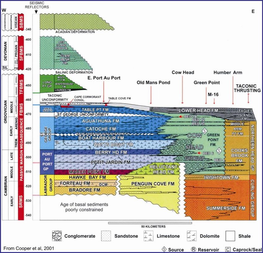
Call for Bids 2009 NL09-03 Western Newfoundland                      Enachescu and Foote
1. Introduction

This report focuses on Parcel 1 of the C-NLOPB Call for Bids NL09-03 which is situated off the
West Coast of the island of Newfoundland, in water depths ranging from the low water tide mark
on the coast to approximately 125 m offshore. The single parcel of this CFB is located within the
open coastline on the eastern margin of the Gulf of St. Lawrence, south of the Bay of Islands and
geologically encompasses the Paleozoic Foredeep and the Appalachian Overthrust Belt (Figures
2 and 3). The parcel on offer is one of the few remaining unlicensed offshore blocks along the
western coast of Newfoundland and is situated north of and on trend with the Port au Port
Peninsula, where light oil and gas were tested at significant flow rates from the Port au Port #1
(PAP #1) well in 1995. The parcel lies adjacent to several active Exploration Licenses (offshore)
and Exploration Permits (onshore) where there is ongoing petroleum exploration consisting of
acquisition of seismic data and drilling (Figures 3 and 4).

This report provides general background on petroleum exploration on Newfoundland’s West
Coast area and general geological information on the hydrocarbon prospectivity of the West
Newfoundland basins, emphasizing the potential of the offshore Anticosti Basin. It also discusses
the specific geology and petroleum potential of the Parcel in Call for Bids NL09-03.

More information on the geology and petroleum potential of the Western Newfoundland and
Labrador region, including evaluations of earlier Call for Bids parcels which became active
Exploration Licences 1097, 1098, 1102, 1103, 1104, 1105, 1070 and 1116 (Figures 3 and 4) can
be accessed at:

   1.   http://www.nr.gov.nl.ca/mines&en/oil/call_for_bids_nf04_01.stm
   2.   http://www.nr.gov.nl.ca/mines&en/call_for_bids/NL05.pdf
   3.   http://www.nr.gov.nl.ca/mines&en/call_for_bids/cfb_nl06-3_%20enachescu_report.pdf
   4.   http://www.nr.gov.nl.ca/mines&en/call_for_bids/CFBNL06-3_presentation.pdf
   5.   http://www.nr.gov.nl.ca/mines&en/oil/NatResPetDevWestCoastSydney.pdf

The accompanying Call for Bids NL 09-01 power point presentation that describes in detail the
geology of Parcel 1, located in the Jeanne d’Arc Basin, southwest of the White Rose oil and gas
field, will be available at http://www.nr.gov.nl.ca/mines&en/oil/ in the fall of 2009. The Call for
Bids Report NL 09-2 and companion power point presentation that discusses the petroleum
geology of the Laurentian Basin and the exploration potential of Parcels 1 and 2 included in the
2009 landsale will also be available from the same website during the fall of 2009.

Additional petroleum related reports from the Department of Natural Resources are available at:
http://www.nr.gov.nl.ca/mines&en/oil/ and http://www.nr.gov.nl.ca/mines&en/publications/.

Selected references on the geological setting and petroleum potential of the West Newfoundland
region are also provided at the end of this report.

NL Department of Natural Resources                                                     -1-
Call for Bids 2009 NL09-03 Western Newfoundland                     Enachescu and Foote
2. Exploration and Development Background
Exploration for oil and gas onshore and offshore Western Newfoundland is less known than the
much larger scale exploration efforts that took place since the 1960s and continues today in the
Mesozoic basins of the Atlantic margin: on the Grand Banks to the east, on the Labrador Shelf to
the north and on the Scotian Shelf to the south. This report will focus on the general setting and
history of petroleum exploration in the West Coast Newfoundland region within a provincial,
regional and international context (Figures 1, 2 and 3).

                                                        Figure 2. Atlantic Canada offshore basins
                                                        map. Mesozoic basins are labelled in red
                                                        and Paleozoic basins are indicated in blue
                                                        (bathymetry map from NRCan). Located
                                                        within the Gulf of St. Laurence the
                                                        Anticosti Basin is predominantly situated
                                                        in shallow water.

                                                        The      Canadian       provinces      of
                                                        Newfoundland and Labrador (NL),
                                                        Nova Scotia (NS) and the Nunavut
                                                        Territory (NU) are the only jurisdictions
                                                        north of the state of Florida allowing
                                                        offshore petroleum exploration on the
                                                        Atlantic side of the North American
                                                        continent. While the pace of discoveries
                                                        have occurred over large time intervals
                                                        and the exploration costs are significant,
                                                        the large size of the hydrocarbon fields
                                                        discovered on the East Coast justify that
                                                        this region be in the E&P portfolio of
                                                        many multinationals and independent oil
                                                        companies.

Traditionally, exploration offshore Newfoundland has targeted mainly oil accumulations in a)
extensional structures located within the eastern Mesozoic rift basins, and b) compressional and
salt induced structures in the western Paleozoic basins. Gas exploration per se is a new
development in the NL offshore basins and it is triggered by a need for a cleaner source of
energy and increased demands from Europe, Central Canada and Northeast USA markets. It is
fair to say that presently both oil and gas resources are targeted in the offshore basins of NL as
well as in the Province’s interior Paleozoic basins.

The Mesozoic extensional and Paleozoic compressional basins distributed around the Province
of Newfoundland and Labrador constitute approximately a 600,000 km2 area with oil and gas
potential. Continental margin fundamental research and offshore oil and gas exploration have
been carried out on the Atlantic region of the Province of NL for almost 5 decades. Accumulated
knowledge is available to the public, including any interested petroleum exploration company,
from many sources including the Geological Survey of Canada, C-NLOPB, NL Department of
Natural Resources and published geoscience literature.

NL Department of Natural Resources                                                    -2-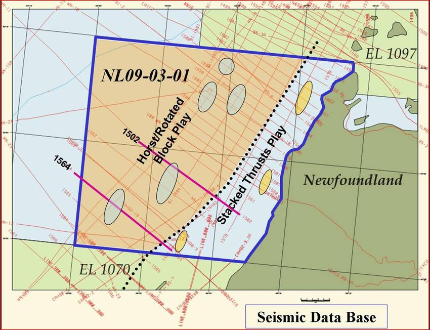
Call for Bids 2009 NL09-03 Western Newfoundland                          Enachescu and Foote

Figure 3. Atlantic Canada offshore basin setting, oil and gas discoveries, land situation as of fall 2009
and NL CFB-09-01, -02 and -03 parcels (in yellow). Mesozoic basins are indicated in green, Lower
Paleozoic basins are labelled in blue and Upper Paleozoic basins are in purple. Parcel NL09-03-01
west of Corner Brook, is situated in shallow water within the Anticosti Basin (map modified after the
GSC, C-NLOPB and Enachescu, 2005).

NL Department of Natural Resources                                                          -3-
Call for Bids 2009 NL09-03 Western Newfoundland                      Enachescu and Foote
NL’s largest oil and gas discoveries occurred between 1979 and 1985 and field developments
started in the late 1990s and continue today (Figures 1, 2 and 3). Several new discoveries and
additions to older fields have recently been announced increasing the size of total proven
reserves offshore Newfoundland and Labrador. A “first ever” discovery in the deeper water of
the poorly explored Flemish Pass Basin was announced in April 2009 by StatoilHydro. There is
no doubt that Mizzen O-16 discovery in Exploration License 1049 will open the way for further
discoveries in the wide deep water area (200-2000 m) surrounding the Province. Significant
exploration activity is also taking place in the ultra-deep waters of the Laurentian and Orphan
basins (2000-3000 m), as well as in the shallow waters of the Labrador’s Hopedale Basin.

The past oil and gas exploration activity in the Western part of the NL Province was intermittent
and less intensive. However, several extant offshore West Newfoundland ELs are now close to
their Period I conclusion when parcels have to be drilled or released. In the ELs 1096-97 older
2D seismic grids were reprocessed and a first ever exploration 3D (dense 2D) survey was
acquired in 2008 and interpreted in 2009. It is expected that at least one exploration well will be
drilled in the shallow waters of the Anticosti Basin within these ELs during the 2010-2011. Other
wells in the remaining offshore ELs may follow, once a shallow water rig is brought to West
Newfoundland.

NL Department of Natural Resources                                                     -4-
Call for Bids 2009 NL09-03 Western Newfoundland                      Enachescu and Foote
2.1. NL Petroleum Production

Offshore Developments. Three large fields - Hibernia, Terra Nova and White Rose - have been
developed in the Jeanne d’Arc Basin which lies to the east of the island of Newfoundland in 80
to 150 m of water (Figures 1 and 3). These fields have produced in each of the past five years in
the range of 300,000 to 360,000 barrels per day of light crude (30 to 35º API) from Mesozoic
sandstones. During 2008 the three fields produced 125.3 million barrels of oil.

Presently NL delivers about 37% of the conventional light oil produced in Canada from these
three producing fields and more than 80% of Atlantic Canada’s offshore hydrocarbon production
comes from NL, which is now the second largest hydrocarbon producing province in Canada.
Over 1 billion barrels has been produced to date from the Jeanne d’Arc Basin where more than
1.8 billion barrels proven remaining recoverable reserves/resources exists and many active
exploration licenses await further drilling. The total estimated Recoverable Reserves of the NL
Province stands at 6 Bbbls oil and 60 tcf natural gas. Up to now four offshore basins have
yielded significant petroleum discoveries and many other basins remain under-explored.

The Jeanne d’Arc Basin developments are the only producing offshore oilfields on the Atlantic
coast of North America. A fourth large field, Hebron-Ben Nevis, estimated to contain 731
million barrels recoverable reserves/resources will be developed starting in 2012 using a concrete
platform to be built in the Province. Hebron’s “first oil” production is scheduled for 2017.

During the past 5 years several large and medium size satellite fields have been discovered and
delineated in the vicinity of production facilities. Hibernia South is an extension of the Hibernia
field and is estimated to contain about 230 million barrels of recoverable oil to be developed
using a combination of existing infrastructure as well as a subsea tieback to the Hibernia
platform. North Amethyst satellite field is located southwest of the White Rose field and is
estimated to contain about 70 million barrels of proven and probable reserves. The field is being
developed using subsea tie-backs to the existent SeaRose FPSO. In the future, a number of
smaller fields including several located in the vicinity of larger fields may also be brought on as
satellite developments using the current infrastructure and subsea installations. One such
example is the 24 million barrel South White Rose Extension development which received
approval in September 2007. Present estimates for discovered reserves and resources in the
Jeanne d’Arc Basin are 2.8 Bbbls and about 6.6 tcf (NL DNR, 2009; C-NLOPB, 2009), with the
greatest majority being contained in the Late Jurassic-Early Cretaceous sandstone reservoirs of
the central Jeanne d’Arc Basin.

The Jeanne d’Arc Basin is only one of many Mesozoic basins and sub-basins located in Atlantic
Canada (Enachescu, 1987; Tankard and Welsink, 1989; Grant and McAlpine, 1990; Enachescu
and Fagan, 2004, 2005a and 2005b; Enachescu and Hogg, 2005; Enachescu, 2005 and 2006c,
NL DNR, 2008; Hawkins et al., 2008; Enachescu, 2008 and Figures 1 to 3). On the Atlantic
Mesozoic trend, exploration for large oil and gas fields continues today with seismic and CSEM
data acquisition, exploration drilling or plans for future drilling in the:

       1) Laurentian Basin, south of Newfoundland;
       2) Orphan Basin, northeast of Newfoundland, and
       3) Hopedale Basin, offshore Labrador (Figure 3).

NL Department of Natural Resources                                                     -5-
Call for Bids 2009 NL09-03 Western Newfoundland Enachescu and Foote
More than 10 tcf of technically recoverable gas has been discovered in the Jeanne d’Arc and
Hopedale basins, but to date only oil developments have occurred in the Province. The oil is
delivered by tanker to markets in eastern North America and the solution gas produced with the
oil (about 450 mmcfd) is mainly being used as fuel or re-injected. However, given the future
demand in the North American and European gas markets, the stakeholders in NL gas are
continuously investigating the commercial and technical aspects of natural gas development
from Newfoundland and Labrador waters. Except for the rapidly declining Sable Project and the
future production from Deep Panuke field on the Scotian Shelf, there are no other offshore
proven sources of gas on the East Coast of North America. Deep Panuke project is estimated to
contain 0.7-0.8 tcf of sales gas and is scheduled to start producing first gas in 2010. In the near
future, the Grand Banks, Labrador and other offshore NL basins will become a very important
North American gas producing area.
No new offshore drilling was performed in West Newfoundland waters to test existing Paleozoic
Exploration Licenses since our last report and power point presentation available from the DNR
website: http://www.nr.gov.nl.ca/mines&en/call_for_bids/cfb_nl06-3_%20enachescu_report.pdf
and respectively http://www.nr.gov.nl.ca/mines&en/oil/NatResPetDevWestCoastSydney.pdf
(Enachescu, 2006a and 2008). One well, Shoal Point 2K-39 was drilled in 2008 by Shoal Point
Energy on behalf of CIVC et al from onshore to offshore to test a possible northern extension of
the Garden Hill field. Results of this well are still being evaluated.
Since 2006, several new offshore NL blocks targeting large Lower Paleozoic structures were
licensed (Figures 4 and 5):
1) EL 1105 by Corridor Resources in the Magdalen Basin (Enachescu, 2007);
2) EL 1115 by Husky Oil in Sydney Basin, both with Carboniferous reservoir potential
(Enachescu, 2006b and 2008), and
3) ELs 1106 to 1109 in the Labrador Sea, with primary reservoir potential in Cretaceous
sandstones and probable secondary reservoir potential in the Ordovician carbonate
forming the area’s basement (Enachescu et al., 2006a, b, c and d; Enachescu, 2008)
by Husky Oil (EL 1006), Vulcan/Investcan (EL 1107) Husky/Suncor (EL 1108) and
Chevron Canada (EL 1009).
NL Department of Natural Resources -6-Call for Bids 2009 NL09-03 Western Newfoundland Enachescu and Foote 2.2. The Emergence of Nalcor Energy In May 2007, the Government of Newfoundland and Labrador enacted legislation to create the province’s energy corporation, Nalcor Energy, which is wholly owned by the Province. Prior to the release of the Energy Plan, government through Nalcor, negotiated equity positions in the Hebron Project (4.9%) at a cost of $110 million and White Rose Growth Projects (5%) at a cost of $30 million pending final reserve determinations associated with Western White Rose. On September 11, 2007, the Newfoundland and Labrador Government released the provincial Energy Plan “Focusing our Energy” a comprehensive document that established new policies for oil and gas exploration and production in the Province’s onshore and offshore regions. The Plan outlines the four levers available to governments as resource owners to ensure sound and effective management and to maximize benefits over the long term. One such lever was the acquisition of equity ownership to ensure first-hand knowledge of how the resources are managed and to share in that management, and to foster closer government industry alignment of interests. The Plan also contained several oil and gas policy actions aimed at increasing exploration and development of oil and gas resources including the implementation of an Offshore Natural Gas Royalty Regime and introduced the concept of a “pioneer project” (http://www.nr.gov.nl.ca/energyplan/EnergyReport.pdf). The NL Government has established a policy to obtain a 10% equity position in oil and gas projects requiring a Development Plan approval, where it fits government’s strategic long-term objectives. Nalcor Energy Oil and Gas Inc. (NEOGI) on behalf of government negotiates payment of its share of the historic exploration costs incurred by the licence co-venturers, as well as contributes its share of subsequent development and operating costs. In December of 2008, government successfully launched Nalcor’s brand and corporate identity. Nalcor Energy has five lines of business: Newfoundland and Labrador Hydro, Churchill Falls, Lower Churchill Project, Oil and Gas and Bull Arm Fabrication. While continuing to manage the performance of its operating units, the company has acquired equity interests in offshore oil projects, facilitated wind development in the province and continues to pursue growth opportunities in the energy sector. Another policy initiative contained in the Energy Plan is government’s intent to invest in onshore and offshore geoscience activities. Thus, $5 million was announced to fund the Petroleum Exploration Enhancement Program (PEEP) in onshore Western Newfoundland and an additional $20 million was provided to fund the Offshore Geoscience Data Project. Under PEEP, DNR in collaboration with the Geological Survey of Newfoundland and Labrador (GSNL) and Nalcor, completed a high resolution aeromagnetic survey covering 7150 km2 (~36,000 line km) of land in Western Newfoundland (Foote, 2009; Kilfoil 2009 and Figure 4). The flight portion of the aeromagnetic survey has been completed and the data has been compiled and is being now interpreted. A fall 2009 release is anticipated. This work is in addition to an aeromagnetic program conducted by GSNL with results released in July. Under the PEEP program, Nalcor has the flexibility to commission seismic work independently and/or partner with private companies. A modern regional grid of seismic data processed to pre- stack time migration is necessary to decipher the complex regional structural architecture of the onshore Paleozoic autochthonous and allochthonous beds. Properly imaging the Triangle Zone NL Department of Natural Resources -7-
Call for Bids 2009 NL09-03 Western Newfoundland                     Enachescu and Foote
and the blind thrust sheets of the Appalachian Foldbelt is essential for choosing further drilling
locations. According to the NL Minister of Natural Resources, Kathy Dunderdale, “Acquiring
seismic data is an expensive undertaking but essential for making crucial exploration decisions.
This program will hopefully result in greater exploration activity" (NL DNR, 2007; Dunderdale,
2007). While an older regional 2D seismic coverage already exists, there is no doubt that new
data acquisition and modern processing is necessary to advance our knowledge of the petroleum
geology of Western Newfoundland. The Offshore Geoscience Data Program is a potential
funding source for future offshore geoscience data collection in Western NL.

In August 2009, Nalcor announced that it had acquired an average of 67 per cent gross working
interest in three exploration permits (EPs 03-101, 03-102 and 03-103) being held by Leprechaun
Resources and co-venturers in the Parsons Pond area of the Great Northern Peninsula in Western
Newfoundland. This represents the company’s first direct involvement with operating
exploration acreage and drilling exploration wells.

Figure 4 Western Newfoundland aeromagnetic coverage financed through PEEP and GSC and
completed during 2008-9. Location of CFB parcel NL09-03-01 is also shown. Map sectors are #1 =
Stephenville (Indian Head); 2 = Corner Brook; #3 = Deer Lake Basin; #4 = Port au Choix
extension; #5 = Port au Choix; POC = Port au Choix area.

NL Department of Natural Resources                                                    -8-
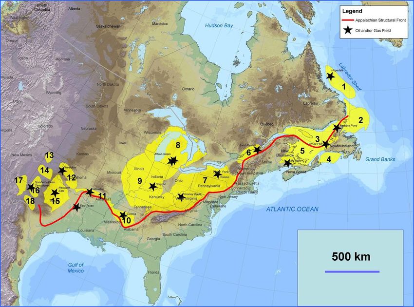
Call for Bids 2009 NL09-03 Western Newfoundland                     Enachescu and Foote
2.3. Large Paleozoic Under Explored Basins

Newfoundland and Labrador’s area of petroleum potential extends outside of the confines of the
Jeanne d’Arc Basin where the Hibernia, Terra Nova and White Rose fields are located. The
continental margin of Newfoundland and Labrador stretches on for more than 1500 kilometres
from west of the Laurentian Channel to the northern tip of Labrador (Figures 1 to 3). Mesozoic
sedimentary basins are found all along the East Coast of the province trending from the
Laurentian Basin in the south, across the Grand Banks basins, through the deeper waters of the
Flemish Pass and Orphan basins and extending north-westward to include several basins along
the Labrador shelf and slope (Figures 1 to 3). Some of these Mesozoic rift basins are incised on a
Paleozoic pre-rift basement that in places contains secondary reservoirs. True Paleozoic basins
and platforms surround the waters of the island of Newfoundland and at least the southern part of
the Labrador margin (Figures 2 and 3).

A total of 150 exploration wells have been drilled in 1.6 million km2 offshore NL area. Only 6
wells were drilled for Paleozoic plays in the Western Newfoundland offshore basins and about a
dozen have penetrated Paleozoic strata, including good quality reservoirs while drilling for
Mesozoic synrift targets on the Grand Banks, Orphan and Labrador basins. The Paleozoic
offshore basins are located in the Gulf of St. Lawrence area, surround the island of
Newfoundland (Sydney Basin to the south, St. Anthony Basin to the north and Bonavista
Platform to the east) and form the upper part of the pre-rift basement of the Grand Banks and
Labrador Sea (Figures 2 and 3).

The western region of NL is part of continental wide Appalachian Structural Front (ASF). This
front stretches from Texas through the eastern US seaboard, the New England states and through
Quebec, and the Atlantic provinces and into Western Newfoundland and contains more than 20
proven petroleum basins. Excellent source rocks and reservoirs yielded numerous discoveries
along the Appalachian foredeep and fold belt. Some of the largest and most productive USA oil
and gas fields are located along the ancient Paleozoic continental margin and the Appalachian
foldbelt within basins such as the Permian, Val Verde, Fort Worth, Anadarko, Arkoma, Black
Warrior, Illinois, Michigan and Appalachian (Figure 5).

On the west coast of Newfoundland, under-explored areas of petroleum potential are found in the
large Paleozoic sedimentary basins within the Gulf of St. Lawrence. The Gulf, excluding all
contained islands and the St. Lawrence estuary, has a water area of approximately 220,000 km2,
or approximately one fourth the size of the Western Canadian Sedimentary Basin. Water depths
on average are less than 100 m except within the Laurentian Channel and associated feeder
tributaries where depths range from 200 to 535 m.

Geologic mapping and past drilling for hydrocarbons indicate that the Gulf of St. Lawrence is
underlain by a thin veneer of glacial sediment covering two adjacent, relatively thick, Paleozoic
aged sedimentary basins known as the Maritime (Magdalen) Basin and the Anticosti Basin.
These basins are large and virtually unexplored.

The Anticosti Basin (named after Anticosti Island) of Cambro-Ordovician to Silurian age
(approximately 510-415 million years old), underlies the northern part of the gulf. The Magdalen
Basin (named after the Magdalen Islands) of Pennsylvanian (Late Carboniferous) to Permian age
(approximately 350-250 million years old), underlies the south. The Bay St. George Basin is an
arm of the predominantly Carboniferous Magdalen Basin (Figure 3). Together, the Anticosti and
NL Department of Natural Resources                                                    -9-
Call for Bids 2009 NL09-03 Western Newfoundland                       Enachescu and Foote
Magdalen basins cover an area approximately the size of the state New Mexico or half of the
Canadian Province of Alberta. These Paleozoic basins also extend eastward into the Province’s
onshore area and to the northeast into the St. Anthony Basin and beneath the Mesozoic sediments
of the Labrador Sea (NL DNR, 2008; Foote, 2008). It is worth mentioning that Canada has a
significant part of its light oil and gas production from Paleozoic sedimentary rocks and over
20% of world oil reserves originate in Paleozoic strata (Enachescu, 2006a and 2008).

Figure 5. North America Appalachian Structural Front and associated foredeep and foldbelt basins
with oil and gas production. Paleozoic basins are: 1. Hopedale (Labrador); 2. St. Anthony; 3.
Anticosti; 4. Sydney; 5. Maritime; 6. St Lawrence Lowlands; 7. Appalachian; 8. Michigan; 9. Illinois;
10. Black Warrior; 11. Arkoma; 12. Anadarko; 13. Dalhart; 14. Palo Duro; 15. Forth Worth; 16.
Midland; 17. Delaware; 18. Val Verde (after NL DNR).

A comprehensive discussion of the Paleozoic basins of Atlantic Canada is contained in several
reports and power points available from the Government of Newfoundland and Labrador
Department of Natural Resources website (Atkinson and Fagan, 2000; Fagan and Hicks, 2005;
Enachescu and Fagan, 2005; Enachescu, 2006a and b; 2008). Additional information on these
basins and their petroleum potential was recently gathered and compiled by the Geological
Survey of Canada (Lavoie et al., 2009).

NL Department of Natural Resources                                                     - 10 -
Call for Bids 2009 NL09-03 Western Newfoundland                       Enachescu and Foote
2.4. E&P Activity in Atlantic Paleozoic Basins

A. Onshore Developments. Onshore, several recent development and exploration wells tested the
Paleozoic basins of the Atlantic Canada. While there is a large potential for non-conventional
petroleum resources in the area, this review is focussed on conventional oil and gas and generally
ignores the areas potential for coal bed methane or shale oil and gas exploration.

New Brunswick. The McCully (Figure 6) gas development onshore New Brunswick (Enachescu,
2006a and 2008) presently produces about 23 mmcfd (17 mmcfd net to Corridor Resources)
from a 400 hectares (approximate 12,000 acre) fractured anticline estimated to contain about 1
Tcf proven and probable gas resource (Corridor AGM presentation, 2009). McCully field
production is from the Carboniferous Hiram Brook Member of the Albert Formation. Reservoirs
are lacustrine sandstone inter-bedded into a mainly shaly succession. A 50 km pipeline connects
the McCully field to the Maritimes and Northeast Pipeline (M&NP) which distributes to the
Canadian Maritime and Boston natural gas markets. Production from this low permeability, low
saturation reservoir is aided now by hydraulically fracturing the reservoir using propane.

In 2008, Corridor while drilling for gas, discovered crude oil at the South Branch G-36 well
situated three kilometers southeast of the McCully natural gas field. Further testing is currently
underway to determine the significance of this 45º API oil discovery that may extend on the
southern fringe of the McCully anticline.

The Stoney Creek Field (Figure 6) discovered south of Moncton, New Brunswick in 1909
produced approximately 804,000 barrels of oil and 28.7 billion cubic feet of natural gas up to the
time of field depletion in 1991. Recently Contact Exploration announced their intention to drill a
horizontal well in this field, re-start production and acquire 2D seismic over a large area south of
the field (Fyffe and St. Peter, 2006).

Prince Edward Island. The only Carboniferous offshore discovery in Eastern Canada, the East
Point E-49 (Figure 6) has tested 5.5 mmcfd from poor permeability Pictou Group sandstone,
probably sourced from same age coal beds. The E-49 SDL, estimated to contain approximately
60-70 Bcf of gas and now belonging to BP Canada is located north-east of PEI in the Magdalen
Basin. Presently, there are five active Exploration Licenses on the island’s onshore. In 2007
Corridor drilled Green Gable #3 and found gas in the Bradelle sandstones, but encountered
problems during stimulation operations and the well is suspended. An earlier Green Gable #2
well produced non-commercial quantities of gas. Another Carboniferous play was drilled by a
partnership including PetroWorth at New Harmony #1 well that had only gas shows. PetroWorth
has acquired 304 km of 2D and 108 km2 of 3D seismic onshore PEI and has partnered with
companies such as Corridor and Ardent to further explore PEI’s Carboniferous potential.

Quebec. Proven petroleum systems have been identified in the St Lawrence and Gaspé basins.
Three gas accumulations were discovered within Paleozoic reservoirs, two of which are located
in the St Lawrence Lowlands Basin and are now depleted and used as gas storage reservoirs:
Pointe-du-Lac on North Shore of St-Pierre Lake producing from coarse well-sorted Quaternary
sands (produced of 2.5 Bcf) and Saint-Flavien (produced 5.7 Bcf). Exploration in this basin has
mainly focused on the Trenton Black-River sedimentary zone (Séjourné, 2009). Ordovician
reservoir and shale gas are also promising exploration plays in the St. Lawrence Lowlands.

NL Department of Natural Resources                                                    - 11 -
Call for Bids 2009 NL09-03 Western Newfoundland                     Enachescu and Foote
In the Gaspé Basin, since 2002, Junex developed the Galt gas field (Figure 6) discovered in the
early eighties. Production is stimulated by fracturing and commercialized by trucking of CNG.
The field is estimated to contain about 1 Bcf gas within oil and gas bearing Devonian
dolomite/carbonate formation (HDT) situated at about 2000 m subsurface.

Just east-southeast of Galt, the Haldimand field (Figure 6) operated by Pétrolia tested 34 bopd of
light crude (50º API) from Devonian sandstones at depths of approximate 1000 m. This “first
Quebec“ - oil discovery is being delineated using 3D seismic, geochemical studies and further
drilling to 1000 + m.

Figure 6. Regional map of the Mesozoic and Paleozoic basins of Atlantic Canada including location
of Call for Bids NL 09-03-01 parcel (modified after GSC). The Carboniferous hydrocarbon fields MC
= McCully, SC = Stoney Creek; GA = Galt gas field ; discoveries EP = East Point E-49, HA =
Haldimand, CP = Cape Breton seeps/shows and coal bed methane; FB = Flat Bay wells that
intersected tight oil zone, WA=West Adventure #1 gas flow, PAC = Port au Choix exhumed oil field
and PAP=Port au Port #1 oil discovery. QC = Quebec; NS = Nova Scotia; NB = New Brunswick;
PEI = Prince Edward Island, NL = Newfoundland and Labrador and #1 = Parcel CFB NL09-03-01.

Quebec is today a hot spot for nonconventional gas exploration: more than 90 per cent of the
known exploration zone in the St. Lawrence basin is already claimed by petroleum companies

NL Department of Natural Resources                                                   - 12 -
Call for Bids 2009 NL09-03 Western Newfoundland                      Enachescu and Foote
such as Gastem, Questerre, Junex, Talisman and Forest Oil. Large gas resources are seen in
Quebec's Utica shale. A Houston consultant company estimated a prospective resource of 4.28
tcf of natural gas in place in the Ordovician Utica shale in the deep fairway of Quebec’s St.
Lawrence Lowlands. Other published numbers are in the tens of tcf of gas resources that remain
to be proven.

Nova Scotia. All of the large oil and gas discoveries and production from Nova Scotia is from
offshore Late Jurassic-Cretaceous sandstones. The onshore extensions to offshore Paleozoic
basins are part of the Appalachian Orogeny or the Carboniferous successor basin stage. These
areas have seen only modest exploration for conventional hydrocarbons. Only about 30 wells
were drilled deeper than 1000 m. No significant discoveries have been made, but oil and gas
shows are recorded from the Sydney, Cape Breton (Figure 6), Antigonish, Cumberland and
Minas basins.

Drilling for unconventional resources is currently taking place in some of these basins. There are
currently four conventional exploration agreements, one Production License and 3 coal bed
methane agreements held by oil and gas companies. Just recently, Triangle Petroleum of Calgary
had success exploring for shale gas at its site in the Kennetcook area, about 70 km north of
Halifax. In April 2009, the provincial government approved Triangle’s 10-year production lease,
which requires the company to drill seven wells at the site by 2014. At least two of those wells
must be drilled by 2010 and the company has to complete three wells drilled last year. Finding
partners and collecting more seismic data are essential for the success of this PL.

B. Offshore Developments. Several large Gulf of St. Lawrence seismic programs in the 1970s
and early 1980s operated by companies such as Mobil, Chevron, Shell, Petro-Canada, etc.,
culminated with the drilling of ten offshore wells, one of which - the East Point E-49 - drilled in
1970 - flow tested at 5 million cubic feet of natural gas per day (Figure 6). This well was drilled
midway between Cape Breton Island and Prince Edward Island and is estimated to contain in-
place gas reserves of 60-70 bcf in Carboniferous sandstone. This early exploration cycle ended
with the oil price collapse of 1982.

During the 1990s, a number of large companies (Mobil, Norcen, BHP, Hunt, Talisman and
PanCanadian) along with several local junior companies explored for petroleum in the onshore
and offshore Paleozoic basins of Western Newfoundland. This exploration cycle resulted in the
acquisition of several nearshore and shallow water marine seismic programs extending from the
southern portion of Bay St. George to Hawke’s Bay in the north (Enachescu, 2006a).

A number of large leads and prospects have been defined in the wide maritime area between
Nova Scotia, PEI, NL and Quebec using the two sets of marine seismic data. One of these
prospects is the Old Harry mapped by Corridor Resources in the Gulf of St. Lawrence. This
project was delineated using densely spaced 2D data collected in 1998 and a 500 km2 3D survey
collected in 2002. The prospect which straddles the boundary between NL and Quebec, has
simple four-way closure covering an area of more than 20,000 hectares, and is one of the largest
undrilled prospects in Eastern Canada. This large size, Windsor salt cored, anticline hosts a
number of potential Carboniferous sandstone reservoirs. The closure is covered by a Quebec
license in the southwest and a NL licence in the northeast (Enachescu, 2008 and
http://www.corridor.ca/oil-gas-exploration/gulf-of-saint-lawrence.html). A hazard-site survey at
a proposed Old Harry drilling location planned for 2009 was recently postponed due to late start

NL Department of Natural Resources                                                   - 13 -
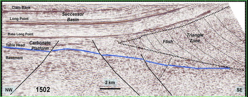
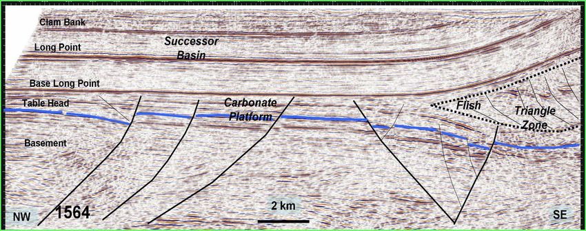
Call for Bids 2009 NL09-03 Western Newfoundland                       Enachescu and Foote
of the implementation of the strategic environmental assessment program in the Gulf of St.
Lawrence by the Quebec Government.

In Nova Scotia, new offshore Cape Breton seismic data was acquired by Hunt Oil in 2005 over
the North Sydney structure. Hunt had two large offshore Exploration Licences that were
abandoned in 2007 without drilling due to lack of partners (Enachescu, 2008).

Currently there is no seismic acquisition work or offshore drilling in any of the Paleozoic basins
of the Atlantic Provinces outside of NL. Several Exploration Licences were awarded in the
Anticosti and Maritime basins in Quebec’s jurisdictional waters. In the early 2000s Hydro-
Quebec had large sums ($300 MM) committed to exploring the Gulf of St Lawrence.
Exploration plans were cancelled after the government raised environmental concerns about blue
whales. Offshore exploration is now under a moratorium.

Several Exploration Licences are active in the Anticosti and Magdalen basins in Quebec’s
jurisdictional waters. While substantial geoscience research has been carried out by GSC-Quebec
in the offshore part of the Laurentian Estuary and St. Lawrence Bay, offshore Quebec, and
especially the Anticosti Basin, the sector is poorly understood and has seen very little exploration
by oil companies in the past decade. According to the GSC, petroleum targets representing the
greatest potential in the region are the Silurian and Devonian sandstones, the hydrothermal
dolomites and breccias, and Devonian and Silurian reefs.

Figure 7. Regional geology map and cross-section of the Port au Port #1 discovery, now the Garden
Hill oil field operated by PDI (after NL DNR). Insert shows the geological interpretation of the
seismic line through the well (modified after Stockmal and Waldron, 1993; Cooper et al., 2001 and
Government of Newfoundland and Labrador Department of Natural Resources). Magenta arrows
show location of the most recent wells on the Port au Port Peninsula.

NL Department of Natural Resources                                                    - 14 -
Call for Bids 2009 NL09-03 Western Newfoundland                     Enachescu and Foote
2.5. West Coast Newfoundland Exploration History

Numerous hydrocarbon seeps, oil shows in historical wells and some early light oil production
are reported in the Paleozoic sedimentary area covering Western Newfoundland. Sporadic
episodes of petroleum exploration in the Appalachian fold belt and Paleozoic foreland of
Western Newfoundland have been ongoing since 1867. Up to now these efforts have been
rewarded only by excellent hydrocarbon shows or hard to evaluate finds, and there has been only
minor commercial production (from the Parsons Pond area) during the early part of the twentieth
century. More recently (1995 to present) production tests and tracking of oil was done from the
Port au Port #1 well and its sidetracks (Figure 8 and Atkinson and Fagan, 2000; Fagan and
Hicks, 2005; Enachescu and Fagan, 2005a and b; Enachescu 2006a and 2008; Hicks, 2008 and
2009).

Figure 8. Hydrocarbon shows and historical
drilling in the Paleozoic sedimentary area
onshore West Newfoundland (after Hicks, 2008)

During the late eighties-early nineties Western
Newfoundland offshore was the scene of
exploration by multinationals and majors (e.g.
Hunt, Talisman, BHP, PanCanadian) who
drilled several deep wells from the Port au
Port Peninsula, one of which being the Port au
Port Garden Hill onshore discovery. This
exploration phase ended with the majors
leaving the area and being replaced by several
home grown companies such as Vulcan
Minerals, CIVC, Deer Lake Oil and Gas,
NWest and Ptarmigan, led by geoscientists
with expertise in the area and who were
encouraged by the significance of the Port-au-
Port discovery.

Junior companies continue to hold lands and
explore both Ordovician and Carboniferous
targets in Western Newfoundland. Interest in a regional hydrothermal dolomite play has more
recently been given a boost by success in similar rocks in New York State (Eaton, 2004;
Atkinson, 2005a and b; Wright, 2007; Maher, 2008 and 2009) and exploration of the trend is
ongoing elsewhere in Atlantic Canada - on the Gaspé Peninsula (Galt), New Brunswick (away
from the McCully field) and on Anticosti Island.

Successful exploration of the hydrothermal dolomite play in New York and in the Rocky
Mountain Foothills has been aided by use of 3D seismic, which can under the right
circumstances allow the direct detection of porosity. Porosity can also be inferred by association
with basement faulting, karstification and platform collapse zones. Unfortunately, only 2D data
has been recorded up to now, both onshore and offshore Western Newfoundland; one small
exploration 3D survey was collected in 2008 by GSI for NWest. The early nineties marine
seismic data is good to fair quality, but the older data acquired prior to 1989 is of poor to fair
quality and largely un-interpretable at depth. Modern offshore data (about 5,000 km) acquired by

NL Department of Natural Resources                                                   - 15 -
Call for Bids 2009 NL09-03 Western Newfoundland                         Enachescu and Foote
several major and intermediary companies during the 1990s provides good imaging of the
subsurface along most of the coastline and is available from C-NLOPB in hardcopy for the cost
of reproduction and for sale in digital form from the data owners. Further offshore and to the
north, the seismic coverage is sparse, and older data is available only on microfiche.

Only six offshore wells have been drilled in the Western Newfoundland jurisdiction, of which
five were directionally drilled from land and one of these had to be abandoned before reaching
its target depth due to operational problems. The five offshore wells drilled from land are all
located on the Port au Port Peninsula and the only one “true” offshore well drilled by a jack-up
(St. Georges Bay A-36) lies to the SE of the Port au Port Peninsula. All of these mid 1990s wells
were located in the vicinity of the Hunt PanCanadian Port au Port #1 (PAP #1) discovery
(Figures 7 and 9). Subsequent drilling of four wells, Hunt PanCanadian Long Point M-16 (drilled
in 1995-6, TD at 3810 m in Port au Port Group), Talisman et al. Long Range A-09 (drilled in
1996, TD at 3685 m in Watts Bight Formation), PanCanadian et al. Shoal Point K-39 (drilled in
1999, TD at 3035 m in Hawke Bay Formation), to test the same target zone in the immediate
area, encountered only shows and based on these results the major operators departed the
province. The shallow Inglewood Man O’ War I-42 (drilled in 1998, TD at 667 m in Forteau
Formation) was terminated due to mechanical problems before reaching the target.

The offshore Hunt PanCanadian St. George’ s Bay A-36 well located in shallow water,
approximately 6 km south-west of the Port au Port Peninsula (drilled in 1996, TD at 3240 m in
Forteau Formation), contained several zones of good to excellent vuggy and cavernous porosity
as well as bitumen and minor live oil shows within known reservoir horizons.

Figure 9. Port au Port #1 discovery, now Garden Hill oil field operated by PDI Production Inc. The
map also contains other exploration wells, Port au Port Side Track wells, wells drilled in 2008 (in red)
and the limits of Lease 2002-01 (PDI et al.) on Port au Port Peninsula (modified after NL DNR).

The key challenge in terms of hydrocarbon prospectivity in the Paleozoic has been in finding
good quality continuous reservoir that contains hydrocarbons. Quality reservoirs have been often
encountered (e.g., Catoche and Watts Bight in the PAP #1 well) but thus far have tested water.

NL Department of Natural Resources                                                        - 16 -
Call for Bids 2009 NL09-03 Western Newfoundland                       Enachescu and Foote
Onshore Activity. Onshore exploration is administered and regulated by the Government of
Newfoundland and Labrador Department of Natural Resources, Energy Branch.

Production Lease in Bay St. George Basin. Port au Port #1 was the first well ever drilled in
Western Newfoundland with the benefit of good seismic data coverage in selecting the location.
Two zones, which are believed to be in communication, tested at rates of about 1500 bopd of
light oil, with gas rates of about 2.5 mmcfd. Extended testing showed the pressure to be
dropping, and subsequent sidetrack drilling by a farmin operator (Canadian Imperial Venture
Corp. - CIVC) indicated a complex reservoir near the wellbore. The well encountered several
reservoirs, one of which was hydrocarbon bearing. Two intervals within the autochthonous,
platformal Aguathuna Formation (Figures 7 and 9) (at approximately 3,400 m KB) flowed at
1,528 and 1,742 bopd of high quality oil (51º API) and 2.6 and 2.3 mmcfd of natural gas,
respectively, with associated water. An extended test over one of the zones flowed a total of
5,012 barrels of oil and 9.2 million cubic feet of gas over a nine day period, but the flow
diminished with time. There are a number of possible explanations why flow rates dropped off at
the time of these initial tests.

CIVC who farmed into the project in October 1999, completed an additional 26 km of 2-D
seismic over the area during the summer of 2000 and followed in 2001, by submitting a
development plan for the newly mapped and renamed “Garden Hill field”. Port au Port sidetrack
#1 drilled in mid to late 2001 failed to encounter commercial hydrocarbons in the upper
Aguathuna Formation. The sidetrack demonstrated that the reservoir around the original PAP #1
well bore was probably an isolated, hydrothermally dolomitized porous zone within a larger
trend.

A Production Lease for developing the field was granted to CIVC in 2002 (Figures 9 and 10).
The field is divided into a South (closure confirmed by discovery well), Central (further lead)
and North (further lead) sector. Since then, CIVC and various partners have conducted
delineation work (2D and 3D seismic planning, deviated and horizontal drilling, and various
tests). A second sidetrack well, Port au Port sidetrack #2 drilled in 2002 towards the northeast
reached in close proximity to the original PAP #1 well and test- flowed 195 bopd and 1.2 mmcfd
of natural gas with no produced water reported.

After several years of financial difficulties CIVC has considerably divested itself from the
Garden Hill Field. A group of companies led by PDI Production Inc. (a subsidiary of Enegi Oil
Plc) now controls ownership of the Production Lease and they have requested a lease extension
from Government. This extension was granted in June 2006 and allows the company and its
partners time to achieve first production and formulate future exploration plans. PDI Production
Inc. (PDIP) took operatorship of the project and re-entered the Port au Port #1 Sidetrack #2 well
in late 2006/early 2007, in order to conduct an extended well test. The test produced excellent
initial results, but was terminated due to problems related to borehole constrictions within open-
hole shaly intervals.

A further production lease extension was granted in August 2007, conditioned by commitment to
drill a well with a minimum expenditure of $10 million no later than August, 2008. PAP#1-ST#3
well produced 460 barrels of oil and was later shut-in. PDIP has subsequently acquired 100%
interest in the Lease and continue to fulfill the conditions of the extension agreement. There is oil

NL Department of Natural Resources                                                     - 17 -
Call for Bids 2009 NL09-03 Western Newfoundland                      Enachescu and Foote
contained in the Garden Hill structure but questions remain as to the size of the accumulation and
how to commercially produce the oil contained in the HTD zones.

Presently, beside the discussed onshore production lease, there are nine onshore exploration
permits issued in three general areas for Western Newfoundland: Flat Bay, Deer Lake and
Parsons Pond, for a total of 228,500 hectares under permit (Figure10).

Figure 10. Onshore Western Newfoundland landholdings and operators of a) the Garden Hill
Production Lease (blue ellipse), and b) Exploration Permits in the Bay St George, Deer Lake and
Parsons Pond basins (yellow ellipses).

Exploration in Bay St. George Basin. The Bay St. George Basin is a Carboniferous strike-slip
successor basin overlying the Western Margin of the Appalachian Orogen (Figures 3, 4 and 6).
Vulcan Minerals of St. John’s, the operator of Exploration Permits 96-05, 03-106 and 03-107
(Figure 10) has drilled seven shallow land wells (less than 1,000 m) in the Bay St. George Basin
in order to test large, structural features that were seismically mapped and confirmed by potential
field data (http://www.vulcanminerals.ca/projects/onshore-petroleum-bay-st-george-nl/).

NL Department of Natural Resources                                                   - 18 -
Call for Bids 2009 NL09-03 Western Newfoundland                     Enachescu and Foote
The Bay St. George Basin is part of the larger Carboniferous aged Magdalen Basin. The basin
was formed as a pull-apart depression and contains more than 10 km of Late Devonian to Late
Carboniferous, mostly terrigenous clastic succession with some marine intervals. Basin fill from
oldest to youngest has been divided into the Anguille, Codroy and Barachois Groups (Knight,
2008; Fagan and Hicks, 2005; Enachescu 2006a and 2008; Hicks, 2009a and b; Laracy, 2008 and
2009).

Historically, most of the activity has been in the north end of the onshore basin where crude oil
was encountered at shallow depths beneath a gypsum quarry in the Flat Bay area, and natural gas
was discovered and flared as part of the same mining operation approximately 50 years ago. In
the past decade, Vulcan drilled 8 shallow wells, acquired 4 seismic surveys and compiled all
existent geologic, seismic and potential field data in the basin. In the Flat Bay area, Vulcan has
encountered a thick oil zone in a shallow, low permeability reservoir (Anguille conglomeratic
sandstone) in several wells. The oil zone is up to 150 m thick, with the top as shallow as 50 m.
The oil is light (34o API) and sweet and appears to be derived from a lacustrine source rock. No
commercial production was obtained from this reservoir, however it continues to be studied.

New seismic lines and high resolution aeromagnetic data collected during 2005-2006 in the Bay
St. George Basin, has allowed the identification of several large structural closures located away
from the Flat Bay anticline (Enachescu, 2006a and 2008; Laracy, 2008 and 2009). In 2006, the
Red Brook #1 well targeted an area 20 km to the southwest of the Flat Bay structure and was
suspended before reaching the target due to mechanical problems. To further delineate prospects
and leads in the northern Bay St. George area, Vulcan collected approximately 57 km of off road
2D seismic data during the later half of 2007. A deep prospect was identified as “Robinson’s”
with a target depth at about 3500 m. Additionally, several other shallow and intermediate depth
leads were mapped.

In early 2008 Vulcan farmed out 50% of their interest in the onshore Bay St. George Basin,
covering approximately 236,000 acres to Investcan Energy Inc., a French company. In the spring
of 2009, these companies drilled two wells in the shallow Flat Bay deposit, both of which
showed oil. In the summer of 2009 the Robinson’s #1 well was spudded with plans to drill a
3600 m hole into a fault-bounded anticline. This will be the first deep well in the underexplored
Bay St. George Basin. At the time of posting this report on the web the drilling reached a depth
of 3440 m and was drilling ahead. A second well Red Brook #1, situated 12 km from Robinson’s
#1 is already being planned and the partners have an option on the rig.

Exploration in Deer Lake Basin. The Deer Lake Basin (Figures 3, 6 and 8) is an inverted
Paleozoic rift basin where the plays involve rotated and inverted blocks containing porous and
permeable North Brook sandstone (Carboniferous) and the deeper dolomitized Ordovician
carbonates. The source rocks are Mississippian lacustrine shales and dolostones of the Forty-five
Brook and Rocky Brook formations (Martin, 2009).

Deer Lake Basin Exploration Permits 93-103 (29,000 ha), 03-104 (25,818 ha) and 03-105
(35,221 ha) were issued in 1993 to St. John’s based Deer Lake Oil and Gas (DLOG). Permit 93-
103 remains valid (Figure 10). While intensive surface geology studies were undertaken, the
licenses have very limited seismic coverage. The recent aeromagnetic data acquisition sponsored
by the Government through PEEP program should advance the knowledge of subsurface
structure and allow preplanning of new seismic acquisition (Figure 4).

NL Department of Natural Resources                                                   - 19 -
You can also read