CAMDEN COUNTY LINK TRAIL, SEGMENTS 1A AND 3
←
→
Page content transcription
If your browser does not render page correctly, please read the page content below

CAMDEN COUNTY
LINK TRAIL,
SEGMENTS 1A AND 3
2021 Rebuilding American Infrastructure with Sustainability
and Equity (RAISE) Grant Application

DTOS59-21-RA-RAISE FY 2021 National Infrastructure Investments
Location: City of Camden and Pennsauken Township, New Jersey
Submitted by: Camden County, New Jersey
Amount Requested: $25 million
The Honorable Secretary Pete Buttigieg
U.S. Department of Transportation
1200 New Jersey Avenue, SE
Washington, DC 20590

Subject: Camden County LINK Trail Segments 1A and 3 FY 2021 USDOT RAISE
Application

Dear Secretary Buttigieg:

  On behalf of the Camden County Board of Commissioners and the over half a million
  residents of Camden County, I am pleased to be able to submit this Rebuilding
  American Infrastructure with Sustainability and Equity (RAISE) Grant Application for
  Segments 1A and 3 of the Camden County LINK Trail for your review. Since 2017
  Camden County has been working steadfastly on turning the concept for a 34-mile trail
  connecting our urban core with our suburban and rural communities into a reality.
  Starting with a feasibility study to understand the best route and approaches to
  dedicating more than four million dollars to the design of priority segments, we have
  built the momentum, community support and enthusiasm and are poised to build and
  transform our county.

  Camden County seeks RAISE grant funding to complete these two key segments,
  located in the City of Camden and Pennsauken Township that consist of over 5.5 miles
  of the LINK. These important sections of the trail will allow safe transportation
  alternative for residents, commuters, and visitors by navigating along and across the
  scenic Delaware River connecting to Philadelphia via the Ben Franklin Bridge and
  bypassing the heavy traffic of Routes 30, 130, and 676.
This application meets all of USDOT’s RAISE grant program criteria. Camden’s
median household income is less than $30,000 a year, and 36% of the population lives
in poverty. Most of this project is located within Areas of Persistent Poverty and will
allow for improvements to the quality of life and economic advantages for city residents
by supporting and driving development and employment opportunities and leveraging
other investments that state, county, and city governments are making into open space
and parks, business districts, transit, and the street network. The quantifiable benefits of
this project, per the Benefit Cost Analysis, will be at least 10 times the cost of the
project.

By reducing emissions through active transportation commutes, incorporating green
stormwater infrastructure reducing the burden on the city’s combined sewer system, and
connecting residents to a series of urban parks and renewed open space, the trail will be
an environmentally sustainable and climate resilient infrastructure investment. The
opportunities for residents to commute safely without the need of costly motorized
transportation, to easily recreate and travel to many parks and playgrounds and to
stimulate the economy by opening and supporting business along the Camden County
LINK Trail will transform Camden City and County for generations to come.

Thank you in advance for your careful consideration of this valuable project. Once
again, we express our strong support for the Camden County application for the RAISE
grant. Please do not hesitate to contact me with any questions or concerns at
jeff.nash@camdencounty.com or 856-225-5466.

Jeffrey L. Nash

County Commissioner
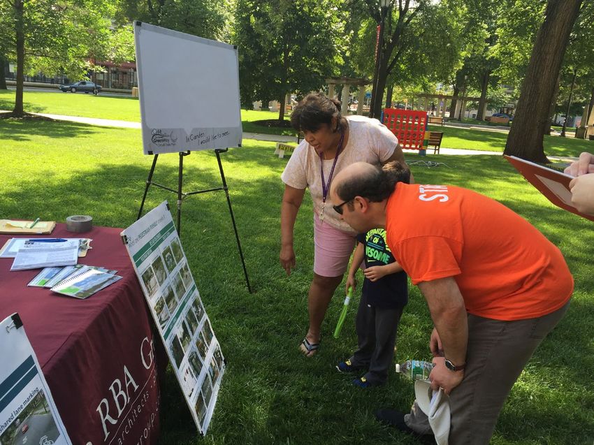
TABLE OF CONTENTS

Cover Letter ...................................................................................................................................................        i
I. Project Description .....................................................................................................................................            1
        Project History ......................................................................................................................................          4
        Transportation Challenges Project Will Address .............................................................................                                    6
        Other Transportation Infrastructure Investments ..........................................................................                                      7
II. Project Location ...........................................................................................................................................        9
III. Grant Funds, Sources and Uses of all Project Funding ......................................................................                                        11
        Prior Costs .............................................................................................................................................       11
        Project Costs .........................................................................................................................................         11
        Funding Commitments .......................................................................................................................                     12
IV. Selection Criteria ........................................................................................................................................         13
        Safety ......................................................................................................................................................   13
        Environmental Sustainability ..............................................................................................................                     15
        Quality of Life ......................................................................................................................................          18
        Economic Competitiveness ................................................................................................................                       19
        State of Good Repair ..........................................................................................................................                 19
        Partnership (Secondary Criteria) ........................................................................................................                       20
        Innovation (Secondary Criteria) .........................................................................................................                       21
V. Environmental Risk Review ........................................................................................................................                   22
        Project Schedule ...................................................................................................................................            22
        Required Approvals ..............................................................................................................................               22
        Assessment of Project Risks and Mitigation Strategies ..................................................................                                        26
VI. Benefit Cost Analysis ..................................................................................................................................            28

APPENDIX
(available at www.CamdenCounty.com/RAISE Password: CityInvincible)

Appendix A: Original County Resolution (passed June 17, 2021)
Appendix B: Revised County Resolution (posted here after approval on July 22, 2021)
Appendix C: Other Funding Letter of Commitment (TA Set-Aside)
Appendix D: Letters of Support
Appendix E: Segment 1A and 3 Detailed Construction Cost Estimates
Appendix F: Segment 1A In-Progress Preliminary Design Plans
Appendix G: Segment 3 Concept Design Plans
Appendix H: Segment 1A and 3 Detailed Project Schedules
Appendix I: Equity Analysis
Appendix J: Benefit Cost Analysis
      Appendix J1: BCA Spreadsheet for Entire Project
      Appendix J2: BCA Spreadsheet for Segment 1A Only
      Appendix J3: BCA Spreadsheet for Segment 3 Only
Appendix K: Federal Wage Rate Certification Letter
Appendix L: NJDOT Coordination Meeting Minutes
Appendix M: Full LINK Map of All Segments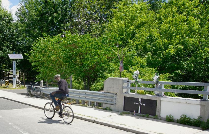
I. PROJECT
DESCRIPTION

The Camden County LINK
Trail (herein after referred to as
“the LINK”) will be a 34-mile
active transportation corridor
located across the heart of
Camden County, New Jersey.
This ambitious plan will involve
the construction of a paved,
12’ wide, all ages and abilities
shared-use (pedestrian, bicycle,
and other personal mobility
devices) path that will act as
the centerpiece of the County’s
bicycle and trail network. The
LINK will begin at the recently
completed Benjamin Franklin
Bridge bicycle/pedestrian
ramp in the City of Camden,
extend through 16 suburban
municipalities, and end in the
Winslow Wildlife Management
Area at the Gloucester County
line. The proposed trail,
which is intended for both
transportation and recreational
use, will connect a diverse
population to numerous neighborhoods, businesses, employment opportunities, parks and open
spaces, and will bisect the urban, suburban, and rural transect of the county.
Camden County seeks Rebuilding American Infrastructure with Sustainability and Equity (RAISE) grant
funding to construct two critical segments of The LINK that are a priority to building both
connections for local travel and momentum for the complete trail. These are identified as Segments
1A and 3 of The LINK. These two segments (herein after referred to as “the project”) are located
in the City of Camden and Pennsauken Township, and consist of about 3.8 miles of new paved
shared-use path and multiple complex structures. The construction of these two segments will
address the following:
  • The project will connect Camden County, New Jersey residents to Philadelphia, Pennsylvania
    via the Benjamin Franklin Bridge and will also extend the regional Circuit Trail network,
    offering future connections to suburban Camden County and beyond.
  • The City of Camden was subject to numerous, large expressway construction projects starting
    in the 1950’s that bisected neighborhoods and cutoff the city from major recreational and
    greenway areas, such as Cooper River Park. No municipality in Camden County has been
CAMDEN COUNTY LINK TRAIL, SEGMENTS 1A AND 3
FY 2021 Rebuilding American Infrastructure with Sustainability and Equity (RAISE) Grant Application   1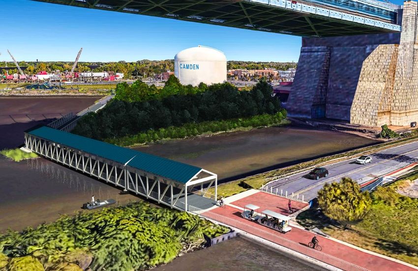
more negatively impacted by expressway construction as the City of Camden. The LINK
     will provide a safe and comfortable active transportation connection between neighborhoods
     separated from each other by these highways and offer a non-motorized travel alternative for
     work or school commute trips.
  • The project will encourage economic development along key areas within the City of Camden
    and Pennsauken Township.
  • The LINK will act as the backbone for the City of Camden’s Active Transportation
    Network. The city is undertaking a planning effort throughout 2021 to refine its vision for an
    equitable and complete bicycle and pedestrian network through the city, which will weave all
    neighborhoods together with a low-stress network and ensure that all residents can access and
    enjoy the LINK.
Segment 1A and Segment 3 are two separate portions of the project that are located immediately
adjacent to each other. While each segment provides independent utility, this narrative will show
that the two segments provide a combined economic, social, and environmental benefit that is
greater than the sum of the two individual segments.
Segment 1A of the LINK consists of a number of trail sections that will close the gaps in the
existing Gateway and Cooper River Park system, specifically:
  • A 12’ wide, 230’ long dual span bridge over the Cooper River alongside Route 30
  • A 1,350’ long
    esplanade along
    the edge of the
    Cooper River that
    will offer trail users
    views of the tidal
    river and both
    downtown Camden
    and Philadelphia
    skylines (right):
  • Enhanced
    crosswalks at Baird
    Boulevard and
    Kaighn Avenue,
    highlighted
    with overhead
    Rectangular Rapid
    Flashing Beacon
    (RRFB) warning
    systems
  • A 12’ wide, 70’
    long bridge over
    Chandler’s Run

CAMDEN COUNTY LINK TRAIL, SEGMENTS 1A AND 3
FY 2021 Rebuilding American Infrastructure with Sustainability and Equity (RAISE) Grant Application   2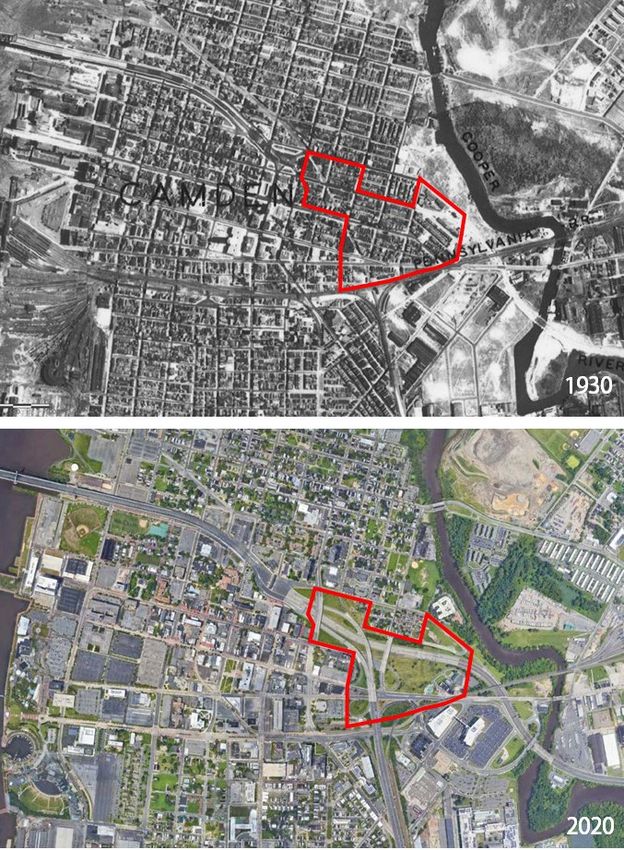
While the length of improvements that Segment 1A will bring are relatively short (1.0 miles), there
are a number of complex structures that will be required to safely carry trail users across water
bodies and a six lane highway and will close gaps in 1.5 miles of existing trails in Gateway and
Cooper River Parks, bringing Segment 1A to a total of 2.5 miles of continuous trail that will be
accessible to all ages and abilities, and finally connect to the greater active transportation network.
Not included in the RAISE grant-funded portion of Segment 1A is the construction of a 118’ long
pedestrian bridge over Crescent Boulevard (Route 130); this portion of Segment 1A was recently
funded by a CMAQ grant awarded by the Delaware Valley Regional Planning Commission and will
now be an independent project.
Segment 3 of the LINK will consist of 2.8 miles of new trail, linking Segment 1A to residential
North Camden, as well as the riverfront, downtown, and the Benjamin Franklin Bridge. In
summary, Segment 3 will contain:
  • A two-span covered bridge to link the
    existing Delaware River promenade to
    Cooper’s Poynt Park, as shown in the image
    to the right.
  • A retrofit of Pearl Street and Delaware
    Avenue to install protected sidepaths within
    the existing street cartways.
  • A segment of trail east of Mastery Charter
    High School that will connect to a new
    wetland park at the mouth of the Cooper
    River
  • A bridge over Route 30 at Flanders
    Boulevard to install a protected sidepath for
    trail users.
  • A major trail gateway, which may include Green Stormwater Infrastructure, at the intersection
    of the LINK with the East Coast Greenway at 10th and State Streets:

CAMDEN COUNTY LINK TRAIL, SEGMENTS 1A AND 3
FY 2021 Rebuilding American Infrastructure with Sustainability and Equity (RAISE) Grant Application   3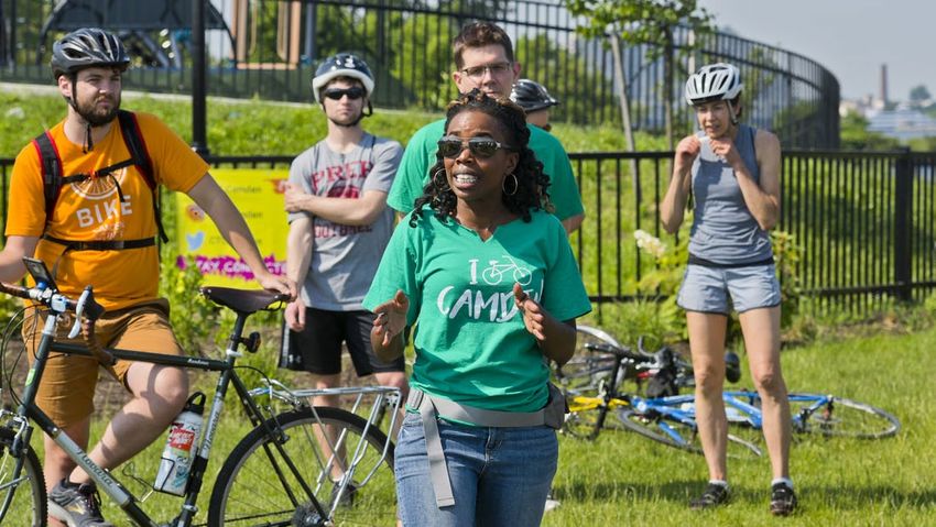
There are 1.1 miles of Segment 3 that have already been built, or that will go to construction starting
in the fall of 2021. Combined with the 2.8 miles that the RAISE grant will fund, Segment 3 will be a
total length of 3.9 miles of shared-use path.
Once the construction of Segments 1A and 3 are complete, it will unlock a total of 6.4 miles of
shared-use path and provide a continuous, safe, and intuitive way to travel by foot, bicycle, scooter,
or skateboard across the City of Camden. The trail design will be considered All Ages and Abilities,
otherwise known as 8-80 Design. Innovative practices to be used on this project include:
  • New paved surfaces of the trail will be constructed with pervious pavement, and the project
    will strive to have zero additional stormwater runoff.
  • The construction of the trail will also contain green stormwater infrastructure installations
    where possible to manage stormwater runoff from adjacent impervious areas, such as city
    streets, reducing the burden on Camden’s Combined Sewer Outfall (CSO) system.
  • There will be very few at-grade trail crossings of roadways, thereby maximizing efficiency
    and safety of the trail users. Where at-grade crossings are needed, practices like high visibility
    crosswalks, raised crossings, mountable turning islands and RRFBs will be used.
A map of the project limits and the two segments is shown on page 10, and current engineering
plans and detailed illustrative layouts are available as appendices on the project website at
CamdenCounty.com/RAISE (password: CityInvincible). A drone video of the entire Segment 1A
and 3 alignment is also available at the project website.

PROJECT HISTORY

The LINK is the culmination of multiple planning efforts that have taken place over the past several
years, and will support the momentum of other ongoing projects throughout the Camden area (see
Section II. Project Location for more detail).
While there were a handful of trail construction projects in Camden County between the 1950’s
and 2000, these efforts strictly revolved around the recreational aspect of trails and there was little
thought about network connectivity and on-street bicycling. Cooper River Park, the jewel of the
County’s park system, is 346 acres, contains five miles of trails, and numerous other recreational and
open space assets, but is only accessible to most area residents by car. Gateway Park, constructed
in 2000 by the Delaware River Port Authority (DRPA), replaced blighted commercial structures and
cleaned up much of the polluted land along Route 30. The park contains one mile of trail (which
is considered a completed portion of Segment 1A), but it too is largely inaccessible to residents
without a car.
Recent trail planning efforts in Camden County have not only considered the need for buildout of
a fully connected network, but include the transportation and utility aspect of trails, in addition to
equity and climate change impacts.
After several years of separate planning efforts in both the City of Camden and nearby suburbs,
Camden County and the Delaware Regional Planning Commission (DVRPC) developed the Camden
County Bicycling & Multi-Use Trails Plan in 2015. This plan contains 550 miles of trails and bike
lanes to be developed across the county into an active transportation network that will connect
CAMDEN COUNTY LINK TRAIL, SEGMENTS 1A AND 3
FY 2021 Rebuilding American Infrastructure with Sustainability and Equity (RAISE) Grant Application      4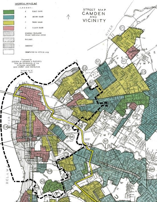
all cities, townships, and boroughs. Concurrently, the Camden Community Partnership (formerly
known as the Cooper’s Ferry Partnership) led the effort with the City of Camden to compile the
Camden GreenWay Trails Plan, which was to identify a system of trails within the city.
With hundreds of miles of active transportation routes identified over two major planning studies,
Camden County and the City of Camden needed a place to start the process of building out the
network. In 2016, Camden County, along with the Camden Community Partnership, initiated the
Cross Camden County Trail Feasibility Study. This study identified the central spine of the entire
550 mile active transportation network, which will connect the major recreational and employment
centers in the county with the densest populated areas via an all ages and abilities shared-use trail.
The feasibility study’s public outreach involved several formal public meetings as well as “pop-up”
meetings at a county park. A combination of online and in-person surveys, as well as an online
interactive project map, allowed a wide range of voices to have a say in the location of the Cross
Camden County Trail. A diverse collation of stakeholders,
representing urban, suburban, and rural residents, helped
guide the project to produce a route varied in its landscape as
it stretches between the busy Camden riverfront to the solace
of the Pinelands.
It was vital to the public and stakeholders that the planned
route start in the City of Camden at the base of the
Benjamin Franklin Bridge. While bicycle and pedestrian
access had always been available on the bridge to connect
to Center City Philadelphia, it was only accessible by way
of a tall and narrow staircase on the Camden side. After
years of advocacy, the Delaware River Port Authority
(DRPA) completed an ADA accessible ramp to the bridge’s
pathway in June 2019. This connection across the Delaware
River also acts as a gateway to the rest of the Circuit Trails
                                                                           Bicyclists make their way up the new Ben Franklin Bridge
network, which is the Philadelphia and Camden region’s
                                                                           ramp in 2019 (Image courtesy of the Camden Courier-
planned 800 mile trail network, which is about 45% complete                Post)
as of 2021.
Upon completion of the Cross Camden County Trail Feasibility Study in 2017, Camden County
released an RFP for design services of the trail in 2018, which has now been renamed the Camden
County LINK Trail. The County selected an engineering and landscape architecture consulting
firm in the spring of 2019 to begin the design and permitting of 20 of the 34 total miles. Since
then, Camden County has been awarded over $5.3 million for the construction of various segments
of the LINK. The first purpose-built segment of the LINK is due to go to construction in 2022
with Transportation Alternatives funding from the New Jersey Department of Transportation
(NJDOT) for Segment 1B in Audubon and Haddon Heights boroughs, and five other segments
(including Segments 1A and 3) are currently in the preliminary design phase. Two other segments
of the LINK will start the design phase in late 2021.
A Camden based non-profit, the Camden Community Partnership (CCP) opened Cooper’s Poynt
Waterfront Park and trail in 2017, which consists of about 0.35 miles of the eventual Segment 3
route. CCP’s design consultants are currently finalizing design and permitting of the North Camden

CAMDEN COUNTY LINK TRAIL, SEGMENTS 1A AND 3
FY 2021 Rebuilding American Infrastructure with Sustainability and Equity (RAISE) Grant Application                   5
Waterfront Park and the River Birch Trail, which will contain 0.5 and 0.25 miles, respectively, of
new 12’ wide trail that will also become a part of Segment 3. These two portions of trail are fully
funded for construction, with work to commence in the fall of 2021.
The City of Camden, through a Local Technical Assistance program with the New Jersey
Department of Transportation, is currently refining its vision for an equitable and complete on- and
off-street bicycle and pedestrian network through the city, called the Camden Active Transportation
Network Vision Plan. The document will be a community-driven plan that will address the lack of
a complete bicycle and pedestrian network, first/last mile connections, and creating an equitable
way for all Camden residents to connect to work, home, and play. The Community Engagement
and Inclusion Plan for this project involves in-person and virtual meetings at events in multiple
Camden neighborhoods, and various outreach tactics to obtain feedback from the diverse City of
Camden population. The LINK will act as a major corridor of this eventual network. The City of
Camden will be the lead facilitator of this plan, with stakeholders including the Camden Community
Partnership, DVRPC, and the Trust for Public Land.

TRANSPORTATION CHALLENGES PROJECT WILL ADDRESS

Up until the mid-twentieth century, the City of Camden was a thriving riverfront city that boasted
over 40,000 manufacturing jobs and a population of nearly 125,000 in 1950. However, due to the
loss of manufacturing and industrial jobs and federal policies
that incentivized suburban living, the population of Camden
quickly declined, and has not seen a rebound even to this day; as
of 2019, the population of Camden is about 73,000.
The expressway building spree of the second half of the
century exacerbated these issues in Camden. While the
construction of the new I-676 and the connection of US 30
to the Benjamin Franklin Bridge brought about quicker motor
vehicle commutes to suburban residents, the heart of the City
of Camden was severed to construct a massive interchange
with numerous loop ramps to downtown streets to allow for
quick ingress and egress. Today, the legacy of this construction
creates a difficult way to navigate the city without a car, as the
few streets that cross this interchange contain high volumes of
high speed traffic. These expressways also make it challenging
to access Gateway Park and Cooper River Park, two of the
largest open spaces in or around Camden, by bike or foot.
It is important to recognize this current state of the built
environment and the difficulty in getting around the city, since
according to 2015-2019 ACS data, census tracts located along or
near the project show that between 22% to 55% of households
do not have a vehicle1. The city’s poverty rate of 36% is more
than triple the national average (10.5%) and all of Camden                    The connection of I-676 and US 30 to the Ben
County (10.7%). The population of the City of Camden is 41%                   Franklin Bridge ripped a hole in downtown Camden,
Black and 51% Hispanic or Latinx2. It is vital that residents                 resulting in the loss of over 40 acres of real estate.
are given a choice of a safe and reliable active transportation
CAMDEN COUNTY LINK TRAIL, SEGMENTS 1A AND 3
FY 2021 Rebuilding American Infrastructure with Sustainability and Equity (RAISE) Grant Application                    6
Killed or Serious Injury Crashes
                                                                                                Crashes by Crash Type
                              (2015-2019), Camden City, NJ
                                                                                             (2015-2019), Camden City, NJ

                                                  equity. A Pedestrian
network, as a matter of affordability and racial27%         detailed                         5%
                                                                                                           2%
Equity Analysis can be found in Appendix I at CamdenCounty.                                                                Pedestrian
                                                            Bicyclist
com/RAISE (password: CityInvincible).
                                                                                                                           Bicyclist
The users of the transportation system in the City3%of Camden      are
                                                         Vehicular/Other

disproportionally affected by
                            70%
                                automobile crashes. While the City                                                         Vehicular/Other

of Camden contains 15% of the entire county’s population, 19%
of all crashes in the county in which someone killed or seriously                                 93%

injured (KSI) occurred in the City of Camden. Almost 40% of all
crashes in the City of Camden are KSI crashes compared to 32%
                                                                                     Killed or Serious Injury Crashes
across the rest of the County.
                                                                                      (2015-2019), Camden City, NJ
The vulnerable users of the transportation system (those who
bike or walk) are most at risk. Over 40% of bicyclist crashes and                                               27%             Pedestrian
35% of pedestrian crashes in the County occurred in the City
of Camden. Between 2015-2019, the City of Camden had the                                                                        Bicyclist

highest number of bicycle and pedestrian crashes (606) out of
any community in Camden County. While people walking and                                                              3%
                                                                                                                                Vehicular/Other

biking in the City of Camden were involved in only seven percent                       70%
of the total crashes reported, they made up a disproportionately
large percentage of those killed in crashes (30 percent)3. Camden
is the 12th most populous city in New Jersey, but has the third
highest number of fatal bicycle and pedestrian crashes out of all                  Despite being in only 5% of crashes citywide,
municipalities in the state.                                                       pedestrians account for 27% of killed or serious
                                                                                   injured in crashes.
The LINK (coupled with the ongoing Camden Active
Transportation Network Vision Plan effort) will truly give Camden
residents a safe way to access jobs, transit, and recreational
opportunities, not only in the city, but in the surrounding suburbs
and in Philadelphia. The project will consist of a number of
grade-separated structures that will finally allow residents and
visitors to safely cross major roadways and the Cooper River by
foot or bicycle, it will connect neighborhoods to employment
centers, and it will connect a number of recreational assets in
the City of Camden. The project will also include some traffic
calming elements that will help set the stage for further work in
the city to manage deadly speeds.

                                                                                   The LINK (in yellow) on top of mapping showing
OTHER TRANSPORTATION INFRASTRUCTURE INVESTMENTS                                    darker shading for higher concentrations of
                                                                                   household with no car available.
Camden County has a long history of maximizing the value of
funding dollars to accomplish projects that provide meaningful
improvement for the City of Camden. In February 2010, Philadelphia and Camden County jointly
received a $23 million Transportation Investment Generating Economic Recovery (TIGER) grant
from the USDOT to build multiple trail segments of a regional network including the Martin
1
  https://www.arcgis.com/home/webmap/viewer.html?useExisting=1&layers=9a9e43ec1603446880c50d4ed1df2207
2
  https://www.census.gov/quickfacts/fact/table/camdencountynewjersey,camdencitynewjersey/IPE120219
3
  Data courtesy of Numetric and New Jersey Division of Highway Traffic Safety
CAMDEN COUNTY LINK TRAIL, SEGMENTS 1A AND 3
FY 2021 Rebuilding American Infrastructure with Sustainability and Equity (RAISE) Grant Application                        7
Luther King Boulevard Waterfront Connection and Pine Street Greenway Enhancement Project.
Camden was awarded its full request of $5.8 million to implement Complete Streets improvements
including streetscape, landscaping, lighting, signing, bicycle lanes and roadway replacement. This
multi- jurisdictional project completed an integrated, multi-county bicycle pedestrian network for
the region, enhancing the region’s livability by increasing active transportation, connecting residential
neighborhoods to commercial corridors and places of work, connecting residents to transit,
sparking economic development, enhancing underserved neighborhoods’ access to green space
and alternatives modes of transportation, and improving public health. This project were certified
complete in July 2017.
Camden County and Camden City enacted measures in 2013 to improve multi-modal transit with
the adoption of Complete Streets policies that prioritize the equitable design of streets for all users
on current and future projects. For example, in 2015, the City of Camden constructed 4.3 miles of
on- road bicycle lanes, expanding the Camden GreenWay Trail Network and connecting key nodes
of activity throughout the City.
Another recently completed TIGER grant project, the Cooper Street Pedestrian Access and
Cooper’s Poynt Road Reconstruction projects in Camden, demonstrate how the City of Camden
continues to successfully use Federal grant money to fund similar infrastructure improvements in
a cost-efficient and impactful way. The Cooper’s Poynt project, with a $15 million contract value,
overhauled key motor vehicle, pedestrian and bicycle connections between the North Camden
neighborhood and several key centers of economic opportunity, including Downtown Camden, the
Camden waterfront, the Ben Franklin Bridge and US Route 30.
Non-profit and agency partners have also completed a number of transportation projects in
Camden. The Camden Community Partnership completed the Cooper’s Poynt Park and Trail in
2017 on the site of a former state prison. The park has stunning views of the Benjamin Franklin
Bridge and the Philadelphia skyline. As mentioned above, the bicycle and pedestrian ramp that
connects to the Benjamin Franklin Bridge was completed by DRPA in 2019.
Future transportation investments that are in the planning or design stage in the City of Camden
include:
• Reconstruction of the Kaighn Avenue bridge over the Cooper River, which will include a
shared-use path to connect to the LINK (currently in preliminary design phase)
• Reconstruction of Harrison Avenue in the Cramer Hill neighborhood into a “green street” that
will contain green stormwater infrastructure and new bicycle and pedestrian accommodations
(currently in conceptual design phase)
• Reconstruction of State Street in north Camden between Delaware Avenue and 10th Street
(Concept Development Report recently completed)
• A $250 million overhaul of the Walter Rand Transportation Center, which is the region’s transit
hub with connections to the NJ TRANSIT River Line and the PATCO High Speed Line.
(currently in conceptual design phase)
• The Glassboro-Camden Line is a planned 18-mile passenger rail line to several South Jersey
communities, and includes two new stations in the City of Camden (EIS recently completed
and submitted to NJDEP)
CAMDEN COUNTY LINK TRAIL, SEGMENTS 1A AND 3
FY 2021 Rebuilding American Infrastructure with Sustainability and Equity (RAISE) Grant Application 8II. PROJECT LOCATION
The project will be located within the City of Camden and Pennsauken Township, Camden County,
New Jersey. The map on the following page provides context for the location of the project. Most
of the project is located within census tracts designated as Areas of Persistent Poverty. The project
is located within the Philadelphia, PA-NJ-DE-MD Urbanized Area and within the 1st Congressional
District of New Jersey. The City of Camden is county seat of Camden County, and is the 12th
most populous city in New Jersey. Camden is located across the Delaware River from Philadelphia,
PA, the country’s fifth largest city.
Current engineering plans and illustrative layouts of
the project are available as appendices on the project
website at CamdenCounty.com/RAISE (password:
CityInvincible). A drone video of the entire Segment 1A
and 3 alignment is also available at the project website.
Camden’s location in the Northeast Corridor is one
reason why employers are flocking to the city. Several
companies have moved corporate headquarters to
Camden: Subaru, the Philadelphia 76ers NBA franchise,
American Water, Holtec International, EMR, The
Michaels Organization, NFI and Conner Strong &
Buckelew. The city has a port on the Delaware River,
and many more private development projects are
proposed across the city. The city is connected to the
NJ TRANSIT RiverLine and PATCO High Speed Line
transit lines, which make connections to Philadelphia and
Trenton and easy transfers to Amtrak to reach New York
City and Washington, DC. Camden is minutes away from
Center City Philadelphia by way of transit, car, bicycle, or
even foot across the Benjamin Franklin Bridge.
The project is also a part of the regional Circuit Trails
network, which is a planned 800 mile shared-use trail
network throughout the nine county Philadelphia and
Camden region. Segment 3 between the Benjamin
Franklin Bridge and State Street has been designated a
portion of the East Coast Greenway, which will someday
be a continuous shared-use path connection between
Philadelphia and Trenton.
Segment 3 is a part of the East Coast Greenway, which will
someday be a continuous shared-use path between Key West,
FL, and Calais, ME, connecting numerous urban areas.
CAMDEN COUNTY LINK TRAIL, SEGMENTS 1A AND 3
FY 2021 Rebuilding American Infrastructure with Sustainability and Equity (RAISE) Grant Application 9Seg LINK
me
nt
3
Seg LINK
me LIN
nt Seg K
3 1A men
t
Seg LINK
me
nt
1A
nt 4
me
Seg
INK
t u re L
Fu nt 4
me
Seg
Fu
tu
Se re
gm LI
NK
en
t5
NOTE: The bridge over U.S. Route 130 is a
separate project and not considered part
of the RAISE grant application.
CAMDEN COUNTY LINK TRAIL, SEGMENTS 1A AND 3
FY 2021 Rebuilding American Infrastructure with Sustainability and Equity (RAISE) Grant Application 10III. GRANT FUNDS, SOURCES, AND USES OF ALL PROJECT FUNDING As stated in Section I: Project Description, the project consists of two separate segments, Segment 1A and Segment 3 of the Camden County LINK, both of which have independent utility. Some smaller portions of Segments 1A and 3 have already been constructed, or are going to construction in the second half of 2021. Those costs are not accounted for in the following estimate; only the incomplete portions of Segments 1A and 3 are considered below. Camden County plans on utilizing a mix of funding sources, some of which have already been obtained, to complete the project. PRIOR COSTS Camden County held a competitive selection for a design consultant in 2019 to perform preliminary and final design and permitting for 20 of the 34 miles of the LINK (including Segments 1A and 3). The county’s source of funding for the design consultant’s fee of $4,579,540 is the Camden County Open Space Trust Fund. Camden County was recently the recipient of $3.163 million Congestion Mitigation and Air Quality (CMAQ) Improvement Program funds for the single-span bridge over Crescent Boulevard (US 130) in Segment 1A. That portion of Segment 1A, which has independent utility, is not considered a part of the RAISE grant application. PROJECT COSTS The total estimated cost of the project is $32.5 million. A summary of these costs is shown in the table below. Detailed construction cost estimates can be found in Appendix E at CamdenCounty. com/RAISE (password: CityInvincible). Costs Segment 1A Segment 3 Total Project Fu Trail Construction (in 2023 dollars) $ 6,290,700 $ 13,994,415 $ 20,285,115 RA Construction Contingency (20%) $ 1,258,140 $ 2,798,883 $ 4,057,023 Pr Construction Management & Inspection $ 754,884 $ 1,679,330 $ 2,434,214 To Other Professional Services* $ 190,076 $ 1,865,572 $ 2,055,648 Ca ROW Acquisition $ 250,000 $ 1,161,000 $ 1,411,000 Ca Utility Relocation $ 120,000 $ 230,000 $ 350,000 To Riparian & Wetland Mitigation $ 1,861,000 $ 46,000 $ 1,907,000 Gr Grand Total $ 10,724,800 $ 21,775,200 $ 32,500,000 *While Camden County has not included the original 2019 design consultant fee in the project costs, since that is a prior expense, there are a number of required supplemental design services required for portions of Segments 1A and 3 that were not included in the original design scope due to ongoing studies. CAMDEN COUNTY LINK TRAIL, SEGMENTS 1A AND 3 FY 2021 Rebuilding American Infrastructure with Sustainability and Equity (RAISE) Grant Application 11
Segments 1A and 3 of the LINK are, on a per-mile basis, the two most expensive segments of the
         entire 34- mile length of the LINK. This is due to the urban environment of the trail, and the need
         for multiple grade-separated structures to span over existing expressways or waterbodies. Segments
         1A and 3 consist of about 18% of the total length of the entire LINK, but are projected to be about
         25% of the total cost.

         FUNDING COMMITMENTS

         Camden County has secured $1 million Transportation Alternatives Set-Aside grant for the two-span
         bridge over the Cooper River in Segment 1A, with an obligation deadline of 4/23/2023, and match
         provided by the Camden County Open Space Fund.
         The remainder of the project match will be provided by the Camden County Open Space Fund.
         A resolution was passed by the Camden County Board of Commissioners on June 17, 2021
         authorizing the submission of a RAISE grant application for $25,000,000. The listed match in
         this resolution is incorrectly stated as $5,000,000. The Board of Commissioners will rectify this
         incorrect match at their meeting on July 22, 2021, and the updated resolution with the correct match
         will be posted at CamdenCounty.com/RAISE (password: CityInvincible).
         The table below summarizes the funding sources for each segment, and for the entire project:

ject     Funding Sources                                        Segment 1A                 Segment 3               Total Project
85,115   RAISE                                             $   7,579,840     70.7% $     17,420,160    80.0% $ 25,000,000      76.9%
 7,023   Prior Federal Award (TA Set-Aside)                $   1,000,000      9.3%                      0.0% $ 1,000,000        3.1%
34,214   Total Federal Commitment                          $   8,579,840     80.0% $     17,420,160    80.0% $ 26,000,000      80.0%
 5,648   Camden County Open Space Funds (TASA Match)       $      250,000      2.3%   $        -        0.0%   $    250,000      0.8%
11,000   Camden County Open Space Funds (RAISE Match)      $    1,894,960     17.7%   $ 4,355,040      20.0%   $ 6,250,000      19.2%
0,000    Total Non-Federal Commitment                      $    2,144,960    20.0%    $ 4,355,040      20.0%   $ 6,500,000     20.0%
 7,000   Grand Total                                       $   10,724,800   100.0%    $ 21,775,200    100.0%   $ 32,500,000   100.0%
0,000

         CAMDEN COUNTY LINK TRAIL, SEGMENTS 1A AND 3
         FY 2021 Rebuilding American Infrastructure with Sustainability and Equity (RAISE) Grant Application                       12
IV. SELECTION CRITERIA
The LINK will bring numerous tangible and intangible benefits to Camden County residents and
visitors, and is an excellent choice for a RAISE Discretionary Grant. Details are provided below for
each of the selection criteria listed in the Notice of Funding Opportunity.
SAFETY
As mentioned on page 7, City of Camden residents
experience higher motor vehicle crash rates than the
rest of Camden County, and vulnerable users of the
transportation system experience disproportional
rates of being killed or seriously injured. Because of
high levels of poverty and low rates of motor vehicle
ownership, transportation safety is absolutely an
equity issue in the City of Camden.
The trail will be an important safety upgrade to
those who bike or walk in Camden, as it will keep
more vulnerable users off of streets and highways. A bicyclist rides by a memorial for a pedestrian killed in a hit and
As shown on the map below, the highest clusters run where the LINK will cross Baird Boulevard in Camden.
of bicycle and pedestrian crashes occur along the
Haddon Avenue, Federal Street, and Mt. Ephraim
Avenue. The LINK will provide an alternative route
for those who bike between southern and eastern
parts of the city to downtown. A map of all bicycle
and pedestrian crashes between 2015-2019 is located
on the next page.
This project is taking a Safe Systems approach to
design. This approach acknowledges the inevitability
of human mistakes, and designs countermeasures
to ensure that if a crash does occur, it is of a lower
severity, and deaths and serious injuries are mitigated.
The LINK will be grade-separated at major highway
crossings, however, there are a few at-grade street
crossings that will occur. The design team is
proposing the following safety countermeasures at
those locations:
• Vehicular right turns across the trail will be
reduced to slow down turning traffic. Where
trucks need to be accommodated, mountable Example of a mountable apron that reduces right turn speeds.
“corner wedges”, like the example to the right,
will be installed to force motor vehicle speeds
down. According to NACTO, corner wedges improve driver yielding compliance4.
4
https://nacto.org/publication/dont-give-up-at-the-intersection/dedicated-intersections/
5
https://www.fhwa.dot.gov/publications/research/safety/pedbike/10043/10043.pdf
CAMDEN COUNTY LINK TRAIL, SEGMENTS 1A AND 3
FY 2021 Rebuilding American Infrastructure with Sustainability and Equity (RAISE) Grant Application 13• Motion detecting rectangular rapid flashing beacons (RRFBs) will be installed at key trail
crossings, giving a clear warning to motorists that trail users are waiting to cross the roadway.
A 2010 FHWA study found that yielding compliance increased from 18% to 88% with the
installation of RRFBs at uncontrolled crosswalks5.
• New traffic signals will be installed at the intersections of 10th and State Streets as well as
Federal Street and Flanders Boulevard intersections.
Mapping of bicycle and pedestrian
crashes in the City of Camden (2015-
2019) reveal that specific corridors are
the most dangerous. The LINK will
provide an alternative travel route for
several of these streets. The current
Camden Active Transportation
Network Vision Plan will identify ways
to reduce vulnerable roadway user
crashes system-wide.
Map Legend
Fatal Crashes
Severe Injury Crashes
Minor Injury Crashes
Possible Injury
Crashes
No Injury Crashes
CAMDEN COUNTY LINK TRAIL, SEGMENTS 1A AND 3
FY 2021 Rebuilding American Infrastructure with Sustainability and Equity (RAISE) Grant Application 14ENVIRONMENTAL SUSTAINABILITY According to the EPA, the transportation sector is the largest producer of greenhouse gas (GHG) emissions in the United States. In 2019, transportation accounted for 29% of GHG, about 1.9 billion metric tons of CO26. As we look for answers for combating climate change, it must be acknowledged that bicycling and walking are unquestionably the most sustainable methods of transport, and that investments in these modes provide some of the best returns for our climate. The LINK will provide an environmental benefit by taking motor vehicle trips off the roads, and, once coupled with the implementation of the Camden Active Transportation Network, will provide the utility of cross-city trips, a viable commuting route to and from Philadelphia and surrounding suburbs, and first/last mile connections to transit. The Delaware River and tidal Cooper River in Camden are expected to rise 1.4 feet by 2050, based on research by Rutgers University7. This issue was taken into consideration as the trail was designed. In order to ensure that the capital investment in the project results in a resilient transportation facility, all new portions of the LINK will be built above the 2 foot sea level rise elevation, as modeled by NOAA. Further, investments by other parties are working to create a sustainable, resilient Camden waterfront. The Trust for Public Land in the summer of 2021 plans to initiate the design of a tidal wetland located along the LINK east of the Mastery High School (see map on page 10 for location). It is planned that the design of the LINK will be integrated into the wetland park, allowing for an opportunity to educate the public about the role coastal wetlands play in climate change and shoreline resiliency. The New Jersey Department of Environmental Protection will open the Cramer Hill Waterfront Park later this year on the east side of the mouth of the Cooper River, which has transformed a landfill into a 62 acre park with 7 acres of tidal wetlands and 450 feet of living shoreline. This park will be accessible via the East Coast Greenway connection to the LINK. The construction of the LINK will also be coupled with green stormwater infrastructure installations along its route. The trail itself will consist of a 12’ wide porous asphalt design, which will infiltrate rainwater directly within the footprint of the trail. Several strategic locations throughout the trail will also be investigated for management of stormwater runoff from nearby by existing impervious surfaces within the public right of way, such as adjacent streets or publicly owned lots. Some of these ideal site locations include: Mastery High School, the proposed East Coast Greenway intersection at 10th and State Streets, and within Gateway Park. Camden County will be coordinating with the Camden County Municipal Utilities Authority (CCMUA) on the design and management of these designs, and they will also be used to offer an educational component on stormwater management along the trail. The project will redevelop several pieces of existing infrastructure to help save costs and resources. Two sections of the LINK will use excess existing curb to curb space on Pearl Street and Delaware Avenue to convert to protected shared-use paths. The project will utilize an existing network of 2.6 miles of trail in various parks to make connections. 6 https://www.epa.gov/ghgemissions/sources-greenhouse-gas-emissions 7 Coastal Effects of Climate Change in Southeastern PA, Delaware Valley Regional Planning Commission, https://drive.google.com/ file/d/1BwzFUM8GxqKgEtmeFNhHLkye8aL7JnTW/view CAMDEN COUNTY LINK TRAIL, SEGMENTS 1A AND 3 FY 2021 Rebuilding American Infrastructure with Sustainability and Equity (RAISE) Grant Application 15
A number of environmental resources (e.g., waterways, wetlands, threatened and endangered species,
cultural remains) exist within the project area. The trail alignments have been set and design will be
advanced to limit impacts to these resources to the maximum extent possible (i.e. construction of
raised boardwalks) while still achieving the project goals.
The project is consistent with the following:
  •   Sustainable Camden County Plan
  •   Camden County Master Plan
  •   New Jersey Draft Climate Change Resilience Strategy
  •   DVRPC Connections 2045 Long-Range Plan
  •   DVRPC Equity Through Access Plan
The project will also implement principles from the Waterfront Edge Design Guidelines, which
promotes resilient, accessible, and habitat-rich riverfronts.
Environmental justice has
been a focus of the project
since the early planning phases.
As previously mentioned,
Camden is a majority-minority
city splintered with numerous
expressways and low rates of
motor vehicle ownership.
The Delaware Valley Regional
Planning Commission
(DVRPC) has compiled an
equity analysis titled Indicators
of Potential Disadvantage
that maps combinations of
populations of interest (such as
racial minorities, limited English
proficiency, and disabled) based
on ACS five year estimates.              The LINK (in yellow) on top of DVRPC IPD mapping, with darker purple the higher concentrations
                                         of disadvantaged populations.
The entire City of Camden has
some of the highest IPD scores
in the entire Philadelphia metro
region. . A detailed Equity Analysis can be found in Appendix I at CamdenCounty.com/RAISE
(password: CityInvincible).
The LINK, and prior planning efforts such as the Camden GreenWay, have had the goal of creating
safe and comfortable corridors that maximize both recreational and transportation (i.e., daily
commuting) aspects of trail use. The LINK (formerly known as the Cross Camden County Trail)
was featured in the Pennsylvania Environmental Council’s Inclusionary Trail Planning Toolkit as a
case study in inclusionary planning.

CAMDEN COUNTY LINK TRAIL, SEGMENTS 1A AND 3
FY 2021 Rebuilding American Infrastructure with Sustainability and Equity (RAISE) Grant Application                    16
Camden County and project partners have undertaken a number of environmental justice initiatives
to not only understand where and how the LINK was to be located, but to also understand BIPOC
attitudes and misconceptions about trails.
• The William Penn Foundation, a local
philanthropic organization, sponsored
the Equity of Access to Trails project
that studied trail use in underserved
areas in the Philadelphia region, with
Camden being one of the four areas
examined. The wide ranging report
surveyed local residents on topics
such as accessibility, public safety, and
maintenance. The report shines a
light on the fact that just building trails
in underserved communities are not
enough; that outreach to communities
and physical upkeep will be vital to
the success of the project. Camden
County intends on making the LINK
a high-visibility project and working
with partners in the City of Camden to Camden GreenWay and LINK “pop up” public meetings were held at
ensure that maintenance of what will neighborhood and regional social events to garner maximum outreach
become the centerpiece
of the county’s trail
system will be kept up.
• The Trust for Public
Land sponsored the
Camden Parks and
Open Space Plan that
used an equity-driven
mapping element to
determine priorities for
rehabilitation and new
parks and open space
facilities within the The Trust for Public Land’s outreach found that trails should be the top open space priority in
city. During the public Camden.
engagement component
of the study, it was
reported that 96% of the over 400 survey respondents felt that trails were the top priority open
space amenity in Camden.
• Further, as mentioned in Section I. Project Description, the City of Camden and NJDOT
have recently started the Camden Active Transportation Network Vision planning process,
which will involve a substantial amount of community outreach about how the LINK can act
as the backbone of a resilient transportation system.
CAMDEN COUNTY LINK TRAIL, SEGMENTS 1A AND 3
FY 2021 Rebuilding American Infrastructure with Sustainability and Equity (RAISE) Grant Application 17QUALITY OF LIFE
This project will not only improve the quality of life for City of Camden residents, but also for
those in surrounding suburban communities and for those traveling or commuting from the city
of Philadelphia. The LINK, coupled with the
rest of the Circuit Trails and Camden Active
Transportation Network, will help provide an all
ages and abilities transportation choice to help
make connections to job centers, healthcare,
and other essential services in and around
the City of Camden. A well connected active
transportation network will be vital for a city in
which more than one-third of its households
do not own a car, and the LINK will act as the
backbone of that network.
As discussed previously in this narrative,
the LINK will help break down the physical
and psychological barriers created by the
construction of the interstate highway system,
which disproportionally affects BIPOC
populations. As with many cities, Camden also
faced a legacy of redlining that affects residents
to this day. A 2016 investigation found that a
Black loan applicant in the Camden area was 2.6
times more likely to be denied a loan8. Redlining
limited intergenerational wealth opportunities,
creating a vicious circle of poverty. Today,
only 39% of Camden households are owner-
occupied9, while nationally, the rate is near 65%.
It was in these redlined areas where expressway
construction took place and splintered
neighborhoods. The LINK will be an attempt
to help stitch neighborhoods back together, Much of Camden (outlined in black
connect residents to good paying jobs, and increase the livability in adjacent dash) and parts of neighboring
neighborhoods. Pennsauken Township were placed
in the lowest grade of “residential
The LINK will directly connect to several public or senior housing security” in 1930’s redlining maps,
developments, including the Abigail House, a 188 bed skilled nursing facility, leading to difficulty for Black residents
and Camden Lutheran Housing. The LINK will also directly connect to to obtain home ownership.
nine parks or open spaces along the Delaware and Cooper Rivers. The
LINK will essentially create a continuous band of park space along the city’s
waterfront, and create open space opportunities that will rival those found in Philadelphia.
8
NJ Spotlight News, As Redlining Persists, Camden Area Among Hot Spots in U.S. for Mortgage Denials, https://www.njspotlight.
com/2018/02/18-02-16-as-redlining-persists-camden-area-among-hot-spots-in-us-for-mortgage-denials/
9
https://www.njisj.org/new_institute_report_erasing_nj_s_red_lines_ties_generations_of_housing_discrimination_to_gaping_racial_
wealth_gap_in_the_garden_state_and_offers_policy_recommendations
CAMDEN COUNTY LINK TRAIL, SEGMENTS 1A AND 3
FY 2021 Rebuilding American Infrastructure with Sustainability and Equity (RAISE) Grant Application 18ECONOMIC COMPETITIVENESS The LINK will provide numerous economic benefits for Camden County residents. Some of those benefits have already been discussed in this narrative, such as providing a safe, low cost transportation alternative that can be coupled with the upcoming on-street active transportation network and transit. The LINK will be central to increasing Camden’s bicycle and pedestrian mode share and first/last mile transit connections, and help lower residents’ (and outside commuters’) reliance on automobiles. The LINK will also be an appealing amenity to visitors that will attract spending, home purchases, and business relocations to an area that is in need of a more resilient tax and employment base. Developers are touting the walkability of new, nearby mixed use developments, and the quick access to Philadelphia and surrounding suburbs via the LINK will be an important amenity. The LINK reaches a variety of land uses, including corporate campuses, industrial and manufacturing, residential, and a college campus. The LINK will also be a two-way street for Philadelphia and suburban commuters reaching jobs in Camden, as well as Camden residents reaching jobs Philadelphia and nearby suburbs. Following New Jersey Public Contracting Laws, Camden County enters into Project Labor Agreements (PLAs) for any projects over $5 million. These agreements welcome diversity to the work site and promote public policy. In any public works project over $2,000.00 Camden County adheres to The New Jersey Prevailing Wage Act (N.J.S.A. 34:11-56.25 et seq.) establishes a prevailing wage level for workers engaged in public works in order to safeguard the worker’s efficiency and general well-being, and to protect them as well as their employers from the effects of serious and unfair competition resulting from wage levels that are detrimental to the efficiency and well-being of all concerned. The Act requires the payment of minimum rates of pay to laborers, craftsmen, and apprentices employed on public works projects. Covered workers must receive the appropriate craft prevailing wage rate as determined by the Commissioner of Labor and Workforce Development. Camden County is now coordinating with the South Jersey Transportation Planning Organization (SJTPO) on a feasibility study to find a trail route to connect the LINK to Atlantic City and the network of trails and bike lanes along the Jersey Shore. A future continuous trail between Philadelphia, Camden, and Atlantic City would be an economic benefit to the smaller communities between these large population centers. The so-called “city to shore” route would be a flat, roughly 70 mile bicycle ride, and would eventually pass through over 20 separate Camden and Atlantic County communities. STATE OF GOOD REPAIR As previously mentioned, the project will close a significant gap in the county and regional (Circuit) trail network, will set the stage for future extensions of the LINK into suburban communities to the south and east of Camden, and will be the backbone of the Camden Active Transportation Network, the city’s on-street bike lane and pedestrian network. The project will make existing and future trail, sidewalk, and bike lanes more useable, and lower the burden for travel by motorized modes. CAMDEN COUNTY LINK TRAIL, SEGMENTS 1A AND 3 FY 2021 Rebuilding American Infrastructure with Sustainability and Equity (RAISE) Grant Application 19
The project is consistent with city (Camden GreenWay), county, and regional (DVRPC) trail plans.
Most of the project funding match and the ongoing operations and maintenance of the LINK
will be provided by the Camden County Open Space Trust Fund. Voters in Camden County first
passed an open space tax in 1999 at $0.01 per $100 of assessed value. The tax was later increased to
$0.02 per $100 of assessed value, in the early 2000s, where it remains today. Currently, the Camden
County Open Space Tax generates more than $7,000,000 annually. Operations and maintenance
of green stormwater infrastructure systems, intended to manage extra public right of way runoff in
Camden (outside of the pervious pavement of the trail itself), will be provided by the CCMUA.

PARTNERSHIP (SECONDARY CRITERIA)

Many stakeholders have worked together to make the LINK a reality. Several portions of
Segments 1A and 3 of the LINK have already been built or will go to construction in 2021. The
DRPA constructed the Gateway Park trails in 2000, with ownership recently being transferred to
the CCMUA. The New Jersey Conservation Foundation is also a partner assisting in managing
Gateway Park, and has dedicated $50,000 toward the construction of the Baird Boulevard crosswalk
portion of Segment 1A. The Camden Community Partnership (CCP), formerly known as Cooper’s
Ferry Partnership, has overseen the construction of Cooper’s Poynt Park, and will see the North
Camden Waterfront Park and the River Birch Trail segment go to construction in 2021. Camden
Community Partnership is currently working with Campbell’s Soup and Subaru to convert an empty
parcel along the LINK near their respective headquarters to an ecological meadow space for the
public to enjoy.
Camden County collaborated on the planning of the LINK with the local MPO, DVRPC, who
manages the regional Circuit Trails plan. The entire LINK Trail has been designated as a Circuit
Trail, which is a part of the regional 800-mile shared-use trail network. As mentioned above, the
county is also coordinating with the SJTPO on connections to the south of Camden County.
The county and the CCMUA will partner up on the project to implement green stormwater
infrastructure (GSI) along the trail alignment. Because most of the City of Camden is located
within a Combined Sewer Overflow (CSO) sewershed, the installation of GSI will help the CCMUA
meet its stormwater runoff goals listed in its recently updated Long Term Control Plan and Selection and
Implementation of Alternatives Report.
Other partnership opportunities include:
  • Working with The Trust for Public Land and Mastery Charter High School to integrate the
    LINK into plans for a wetland park at the mouth of the Cooper River (as detailed in the
    Environmental Sustainability section above).
  • The LINK will serve as a path to several historical sites, including the Benjamin Cooper House
    (built 1734), Joseph Cooper House (built 1695), and Cooper River Park, in addition to many
    other along future LINK segments.
  • CCP’s alliance with neighborhood groups, such as Parkside Business & Community in
    Partnership and North Camden, will be valuable during upcoming public outreach conducted
    for the design phase improvements.

CAMDEN COUNTY LINK TRAIL, SEGMENTS 1A AND 3
FY 2021 Rebuilding American Infrastructure with Sustainability and Equity (RAISE) Grant Application   20
You can also read