Catalogue of extreme wave events in Ireland: revised and updated for 14 680 BP to 2017 - Nat. Hazards Earth Syst ...
←
→
Page content transcription
If your browser does not render page correctly, please read the page content below
Nat. Hazards Earth Syst. Sci., 18, 729–758, 2018
https://doi.org/10.5194/nhess-18-729-2018
© Author(s) 2018. This work is distributed under
the Creative Commons Attribution 4.0 License.

Catalogue of extreme wave events in Ireland: revised and updated
for 14 680 BP to 2017
Laura O’Brien1 , Emiliano Renzi2 , John M. Dudley3 , Colm Clancy1 , and Frédéric Dias1,4
1 School   of Mathematics and Statistics, University College Dublin, MaREI Centre, Dublin, Ireland
2 Centre  for Data Science, Loughborough University, UK
3 Institut FEMTO-ST, UMR 6174 CNRS, Université de Franche-Comté, Besançon, France
4 Centre of Mathematics and Their Applications (CMLA), ENS Paris-Saclay, CNRS, Université Paris-Saclay, 94235 Cachan

Correspondence: Frédéric Dias (frederic.dias@ucd.ie)

Received: 8 June 2017 – Discussion started: 27 July 2017
Revised: 11 January 2018 – Accepted: 15 January 2018 – Published: 6 March 2018

Abstract. This paper aims to extend and update the survey of       of great interest to wave energy companies. This is particu-
extreme wave events in Ireland that was previously carried         larly prevalent in the face of coastal erosion, rising sea lev-
out by O’Brien et al. (2013). The original catalogue high-         els and uncertainty about how the wave climate will change
lighted the frequency of such events dating back as far as         in a warming world. However, much of the current research
the turn of the last ice age and as recent as 2012. Ireland’s      is based on modelling and experiments. Aside from Kharif
marine territory extends far beyond its coastline and is one       and Pelinovsky (2003), Tinti et al. (2004), Nikolkina and Di-
of the largest seabed territories in Europe. It is therefore not   denkulova (2011) and O’Brien et al. (2013), there are few
surprising that extreme waves have continued to occur reg-         studies documenting the observations of such events.
ularly since 2012, particularly considering the severity of           The purpose of this paper is to extend and update the work
weather during the winters of 2013–2014 and 2015–2016.             of O’Brien et al. (2013), a catalogue of extreme waves around
In addition, a large number of storm surges have been identi-      the island of Ireland. Ireland’s marine territory extends far
fied since the publication of the original catalogue. This pa-     out into the Atlantic and covers approximately 880 000 km2 .
per updates the O’Brien et al. (2013) catalogue to include         O’Brien et al. (2013) documented extreme wave events ex-
events up to the end of 2017. Storm surges are included as         tending as far back as 14 680 BP and as recent as 2012, in-
a new category and events are categorised into long waves          cluding storm waves, rogue waves and tsunamis. Since its
(tsunamis and storm surges) and short waves (storm and             publication, an Irish Coastal Protection Strategy Study (The
rogue waves). New results prior to 2012 are also included          OPW and RPS, 2013) has highlighted the huge number of
and some of the events previously documented are reclas-           storm surges that have occurred in Ireland. We therefore in-
sified. Important questions regarding public safety, services      corporate storm surges as an additional category in this pa-
and the influence of climate change are also highlighted.          per. We also distinguish between two wave groups, long and
An interactive map has been created to allow the reader to         short, since their characteristics are distinct. Our study in-
navigate through events: https://drive.google.com/open?id=         cludes new events that have been identified prior to 2012,
19cZ59pDHfDnXKYIziYAVWV6AfoE&usp=sharing.                          recategorises events from the previous catalogue (O’Brien
                                                                   et al., 2013) and extends this catalogue out to 2017.
                                                                      The paper is organised as follows: Sect. 2 gives an
                                                                   overview of the categories of ocean waves included in this
1   Introduction                                                   study, and Sect. 3 revisits the events from O’Brien et al.
                                                                   (2013). New events identified prior to 2012 are outlined in
The study of extreme wave events in the ocean has become           Sect. 4, and a catalogue of events from 2012 to 2017 is laid
a popular area of research in recent years. Aside from sea         out in Sect. 5. A wider selection of issues relating to extreme
farers, extreme waves impact coastal communities and are

Published by Copernicus Publications on behalf of the European Geosciences Union.
730                                                                           L. O’Brien et al.: Extreme wave events in Ireland

waves are discussed in Sects. 6–9: boulder deposits, climate        Table 1. Classification of short waves (storm waves, rogue waves)
change, public awareness and services, respectively.                and long waves (tsunamis) according to their wavelength, depth and
                                                                    period. Note that storm surges are not included as the range of pa-
                                                                    rameters is difficult to evaluate.
2   Categories of ocean waves
                                                                                                  λ              h              T
In O’Brien et al. (2013) waves were broken into three cat-                Storm wave      10–500 m      5 m–4 km          2.5–20 s
egories: storm waves, rogue waves and tsunamis. Storm                     Rogue wave      10–500 m      5 m–4 km          2.5–20 s
surges and meteotsunamis were included as a subsection of                 Tsunami wave    1–200 km     50 m–4 km     15 min–2.5 h
tsunamis as they are both long-period waves with a meteo-
rological origin. Since this publication, new data (The OPW
and RPS, 2013) highlighted a huge number of storm surge
events between 1961 and 2005. With this in mind, upon re-           ple, although kh is generally large for short waves, a rogue
view of the events documented in O’Brien et al. (2013), some        wave was measured by a Waverider buoy at Killard (Fig. 13)
have been recategorised as storm surge events. In this paper,       in 39 m depth with a corresponding kh value of 0.74.
we give storm surges its own category due to the large quan-
tity of events that have come to light.                             2.1     Short waves
   In addition, we feel it is appropriate to divide the wave cat-
egories into two streams: long waves and short waves. Gen-          2.1.1    Storm waves
erally, the ratio of depth to wavelength is used as a parameter
to differentiate between long and short waves. Long waves           Storm waves are wind surface waves that reach unusually
can be modelled using a simplified set of equations, called         large amplitude due to forcing by strong winds. For example,
the shallow water equations. Tsunamis and storm surges are          storm to hurricane force winds ranging from 10 to 12 on the
typically very long waves, so they are considered shallow wa-       Beaufort scale have probable maximum wave heights from
ter waves. Storm waves and rogue waves are much shorter in          12.5 to 16 m and beyond (The Met Office).
wavelength relative to the ocean depth. The dimensionless              The prevailing wind direction in Ireland is from the south
wave number used to differentiate between long and short            and the west, and on average there can be more than 50
waves is kh, where k = 2π/λ, λ is the wavelength and h is           days with gales (10 m wind speeds > 17.2 m s−1 ) a year at
the water depth. Tsunamis and storm surges have kh values           northern coastal locations such as Malin Head (Met Éire-
of the order 10−3 –10−1 , while for storm waves and rogue           ann, 2016c). Figure 1a shows the percentage frequency of
waves kh values are of the order 1–103 .                            wind direction at numerous locations around Ireland, and the
   It is important to note that there are various different clas-   percentage of calm days (< 0.3 m s−1 ) is circled. Note that
sifications for the boundary between long and short waves.          while an inland area like Birr has approximately 1 in 10 calm
For example, kh ∼ π4 = 0.79 (Fenton, 1979), kh ∼ π5 = 0.63          days, coastal areas like Malin Head and Rosslare have ap-
                                  π                                 proximately 1 in 100 and 1 in 200 days that are calm, respec-
(Dingemans, 1997) and kh ∼ 10       = 0.31 (Dean and Darym-
ple, 1991). However, in this paper we stick to the values that      tively. Figure 1b shows the maximum gust speed likely to
are representative of tsunamis and storm surges (kh ∼ 10−3 –        be exceeded once in 50 years. Note that hurricane winds are
10−1 ) and storm and rogue waves (kh ∼ 1–103 ) to differen-         those that exceed 32.7 m s−1 and the contours on this map
tiate between long and short waves.                                 range from 44 to 50 m s−1 .
   Typical values for wavelength (λ), water depth (h) and              In addition, waves approaching a cliff can be significantly
period (T ) for storm waves, rogue waves and tsunamis are           amplified by a variable coastal bathymetry. Herterich and
given √in Table 1. The dispersion relation√ for short waves         Dias (2017) have shown that the waves could be amplified
(ω = gk) and for longer waves (ω = gk tanh(kh)) is used             nearly 12 times around the Aran Islands (three islands off
to calculate the range of periods, T in this table. For long        Co. Galway, on the west coast of Ireland).
waves we calculate the period based only on the upper limit            With strong winds so prevalent in Ireland and coastal
of λ.                                                               bathymetries potentially favouring significant wave ampli-
   Note that storm surges are not included because the range        fication, storm waves are an important category of extreme
of parameters is difficult to evaluate. For instance, it can be     ocean events in this catalogue.
difficult to put a lower bound on the period of long waves.
The Typhoon Haiyan storm surge lasted less than 1 h. How-           2.1.2    Rogue waves
ever, Roeber and Bricker (2015) replicated this event, show-
ing that it was mainly due to the abrupt breaking of ener-          Rogue waves are large-amplitude waves surprisingly appear-
getic storm waves over the steep reef face rather than a storm      ing on the sea surface (Kharif and Pelinovsky, 2003). They
surge. Table 1 can be used as a guide, but there are always         seem to appear from nowhere with a height 2–3 times that
going to be events that are exceptions to the rule. For exam-       of the surrounding sea state, exist for a short time and then

Nat. Hazards Earth Syst. Sci., 18, 729–758, 2018                              www.nat-hazards-earth-syst-sci.net/18/729/2018/
L. O’Brien et al.: Extreme wave events in Ireland                                                                               731

                                                                                                      .

Figure 1. (a) Percentage frequency of wind direction with circled number representing the percentage of calm days. (b) Maximum gust
speed likely to be exceeded once in 50 years (m s−1 ) (Met Éireann, 2016c)

disappear. The mathematical criteria                                Higgins (1956). In particular, he points out that the theory
                                                                    indicates we should expect one in 1175 waves to exceed 3
H /Hs > 2 and/or ηc /Hs > 1.25,                                     times the average wave height (∼ 1.9Hs ) and one in 300 000
                                                                    waves to exceed 4 times the average wave height (∼ 2.5Hs ).
where H is the (trough-to-crest) wave height, ηc is the crest          Baschek and Imai (2011) present global maps of predicted
height and Hs is the significant wave height, are commonly          likelihood of encountering a rogue wave within a 24 h period,
used (Dysthe et al., 2008) to classify rogue waves.                 based on observations of 7157 rogue waves over 81 years.
   Rogue waves are also referred to as freak waves, monster         For example, they predict a 0.8–1.2 % chance of encounter-
waves or king waves. Once thought to be folklore of seafar-         ing a rogue wave exceeding 11 m along the main shipping
ers, they are now accepted as an important class of wave.           routes in the North Atlantic.
This is due to recent scientific investigations motivated by           Note that field measurements of maximum wave heights
accounts of huge waves hitting ships (Kharif and Pelinovsky,        (H ) in constant depth generally do not exceed 0.55h (where
2003; Didenkulova et al., 2006) and measurements of unusu-          h is water depth) and tend to break before reaching this
ally large waves from oil platforms (Olagnon and Prevosto,          height (Nelson, 1994; Babanin et al., 2001). Experimental re-
2004; Magnusson and Donelan, 2013; Christou and Ewans,              sults by Grue et al. (2014) closely agree with this for strongly
2014; Fedele et al., 2016; Cavaleri et al., 2016; Donelan and       breaking waves (H < 0.56h) but exceed this value for mod-
Magnusson, 2017). Rogue waves are random in nature, oc-             erately breaking waves (H < 0.63h), while numerical results
cur in both deep and shallow waters and may act as a sin-           (Zhang and Schäffer, 2007; Yang et al., 2013) again exceed
gle wave or a group of waves. It is almost certainly the case       this value but not by much (H < 0.6h). Therefore, we expect
that different mechanisms can contribute to the formation of        H = 0.55h to be a good indicator of the maximum rogue
rogue waves, including both linear and nonlinear processes          wave heights in the ocean, while H < 0.63h would be the
influencing waves both in the local vicinity of a wind sea, as      upper limit in idealised situations.
well as propagating swell. For example, linear superposition
and directional focussing effects could readily increase local
wave height in the presence of local wind, whilst nonlinear         2.2     Long waves
instabilities could increase local wave group amplitude for a
propagating swell.                                                  2.2.1    Tsunamis
   Work using analogies between ocean deep water waves
and light propagation has indeed been able to confirm many          Tsunami waves are mainly generated by earthquakes, land-
predictions (Peregrine, 1983) of nonlinear deep water wave          slides or volcanic activity displacing large volumes of water.
growth and decay in an optical environment (Kibler et al.,          They can have wavelengths of the order of 100 km and travel
2010, 2012). However, Fedele et al. (2016) recently inves-          at around 800 km h−1 . Although waves are usually only a few
tigated real-world ocean rogue waves and showed that their          tens of centimetres high in the open ocean, they can become
observed results could be explained by directional focussing.       catastrophically big as they are compressed and slow down
A discussion of linear and nonlinear rogue wave mechanisms          along the shoreline. They have devastated countries at severe
is given in Dudley et al. (2013).                                   human cost, wiping out miles of coastline, towns and villages
   Draper (1971) discusses the expected frequency of large          on a path of destruction. The recent events in Japan in 2011
waves in the context of the statistical distribution of the max-    and Indonesia in 2004 are a stark reminder of their destruc-
ima of a random function theory by Cartwright and Longuet-          tive power.

www.nat-hazards-earth-syst-sci.net/18/729/2018/                               Nat. Hazards Earth Syst. Sci., 18, 729–758, 2018
732                                                                         L. O’Brien et al.: Extreme wave events in Ireland

   It is common that the first sign of a tsunami is an extreme    the water pile up along the shore. It is a long-period wave
withdrawal of the sea followed by a wave that seems small         and can have particularly destructive effects in coastal areas
in the distance, but which grows rapidly and can be followed      where there is a significant difference between low tide and
by successive waves for sometime after. The first wave is not     high tide.
always the largest (Stefanakis et al., 2011; Okal and Syno-          In Europe, storm surges alone usually do not generate
lakis, 2016). Without the proper infrastructure and education     coastal flooding. Coastal flooding occurs when a storm surge
of the warning signs and evacuation methods, tsunamis can         hits the shore together with high tides. To the coastal com-
have deadly effects on coastal communities.                       munities, the effect of the surge-tide coupling is the same as
   Small tsunamis can also occur. They appear as distur-          a small tsunami despite the physics being very different.
bances with the same generation mechanisms and charac-               The climate in Ireland is dominated by the Atlantic Ocean,
teristics of a tsunami without being life threatening. There      in particular the structure of the polar front over the Atlantic
are cases in harbours where the tide has unexpectedly risen       and the associated weather systems that travel across Ireland.
and fallen repeatedly every few minutes over the course of        These systems can often amplify and become large-scale de-
an hour or two. For example, in Rabaul, Papua New Guinea,         pressions that move north-eastwards across the North At-
a small tsunami occurred on 29 March 2015: “residents no-         lantic and pass to the north-west of Ireland (Met Éireann,
ticed the sea level rose slightly, prompting ocean water to       2016b). Sometimes this can lead to storms travelling across
flood the parking lot of a shopping center near the beach”        the ocean that initiate storm surges and lead to coastal flood-
(National Oceanic and Atmospheric Administration, 2015).          ing.
   Large ships moving over appreciable depth changes are             The period of storm surges can range from 2.5 h to a day
one source of small tsunamis; they have recently been ob-         and excludes wind waves and choppy sea, since they are
served in the Oslofjord in Norway. These waves pose a dan-        characterised by periods smaller than a minute. The only for-
ger to coastal communities and may contribute to coastal ero-     mal difference between a storm surge and a meteotsunami
sion (Grue, 2017).                                                consists of the difference between their maximum periods.
   Another source of small tsunamis are meteotsunamis.            The maximum period for a tsunami does not exceed several
These are waves with tsunami-like characteristics but are         hours, while storm surges may last up to a day.
caused by air pressure disturbances often associated with
fast-moving air such as squall lines. Their development de-
pends on the characteristics of the disturbance (speed, inten-    3     Events 14 680 BP–2012 revisited
sity, direction) and they can be magnified by resonances asso-
ciated with the depth of the water or when travelling in semi-    The catalogue of events from O’Brien et al. (2013) has been
enclosed water bodies (National Tsunami Hazard Mitigation         revisited here. In some cases events are reclassified as storm
Program, 2015). Although there are not many documented            surges based on descriptions of the event. In other cases, new
incidents of meteotsunamis relative to regular tsunamis, and      references have come to light, providing additional informa-
even fewer meteotsunamis that have become dangerous, a            tion about the event. Table 2 lists every event from O’Brien
number of damaging meteotsunamis have occurred in vari-           et al. (2013) and indicates whether the event has been up-
ous parts of the world. This includes waves of up to 6 m in       graded to a storm surge or if new information has been found.
Vela Luka, Croatia, in 1978 (Vilibić et al., 2014), a 5 m wave   Section 3.1 elaborates on each of these events.
that killed three people in Nagasaki Bay, Japan, in 1979 and
                                                                  3.1     Additional information
more recently a 2 m wave injured three people in New Jersey
in 2013 (Bailey et al., 2014).                                    3.1.1    1894: the Mullet Peninsula, Co. Mayo (S1)
   If there is no known origin of a tsunami-like wave it can
be difficult to differentiate between a small tsunami and a       The 29 December 1894 event has been upgraded to a storm
meteotsunami. For example, underwater landslides can oc-          surge due to the eyewitness description of a terrible gale that
cur without notice other than the generation of a wave, so it     was blowing all night, with “Green seas . . . going over our
is important to consider different generation mechanisms in       houses” and all the rooms “filled with the sea” (Ryan, 1895).
each case.                                                        On reflection this account is more akin to the description of a
                                                                  storm-induced coastal flooding event rather than an isolated
2.2.2   Storm surges                                              storm wave.

A storm surge is an unexpected rise in seawater level gener-      3.1.2    1881: Calf Rock, Co. Cork (S2)
ated by a storm. The low-pressure area near the storm’s eye
reduces the weight of the air over the ocean. This creates a      A new reference to this event gives some more information
swell in the sea which is pushed towards the coast by the         about what took place on the rock. The description of flood-
strong winds. As the storm approaches the coast, the com-         ing suggests that this was actually a storm surge event. “It
bined effect of the low pressure and the violent winds makes      was blowing a stormy gale from NW, accompanied by lurid

Nat. Hazards Earth Syst. Sci., 18, 729–758, 2018                            www.nat-hazards-earth-syst-sci.net/18/729/2018/
L. O’Brien et al.: Extreme wave events in Ireland                                                                                                              733

Table 2. List of events from O’Brien et al. (2013) with any new                                    flames of lightning every minute . . . three heavy waves struck
information or revisions.                                                                          the tower . . . The three of us were in the basement story all
                                                                                                   this time, and when the wave struck the tower, breaking it off
      Label                                          Event                              Update
      S1                       1837, 1861, 1894, 1935,        1894 recategorised as storm surge
                                                                                                   above the basement, the rush of water, bricks, and all came
                                    1987, 1988 & 1989:                                             down into the basement story, washed us down to the door,
                            Mullet Peninsula, Co. Mayo
                                                                                                   and we were up to the armpits in water . . . . when the sea
      S2           1869 & 1881: Calf Rock, Co. Cork              New reference for 1881 event,
                                                                  recategorised as storm surge.    came in we had to jump on the chairs.” (The Horsham Times,
      S3                   1839: Night of the Big Wind         Likely that this includes a storm   VIC, Australia, 28 January 1882, State Library Victoria).
                                                                   surge at the Cliffs of Moher
      S4                       1864: Valentia, Co. Kerry
                                                                                                   3.1.3   1839: the Night of the Big Wind (S3)
      S5                           1877: railway lines,           Recategorised as storm surge
                             Co. Dublin & Co. Wicklow
      S6                              1899: Greenore,
                                                                                                   The Night of the Big Wind, 6–7 January 1839, was one
                         Carlingford Lough, Co. Louth                                              of the most damaging storms Ireland has ever encountered.
      S7                       1941: Inisheer lighthouse,
                                         the Aran Islands
                                                                  Recategorised as storm surge     This was originally listed under the storm wave category in
      S8                   1945: Rosslare, Co. Wexford            Recategorised as storm surge
                                                                                                   O’Brien et al. (2013). However, upon reflection of some of
      S9                          1951: Kilkee, Co. Clare
                                                                                                   the descriptions it is likely that a storm surge occurred along-
      S10                               1953: Aran Islands        Recategorised as storm surge     side storm waves in some regions. The description of how
      S11                                   1962: Co. Cork                                         high the waves were at the Cliffs of Moher and the Aran Is-
      S12                  1974: Kilmore, Co. Wexford                                              lands indicates that a storm surge most likely occurred: “the
      S13                               1979: Fastnet Race                                         waves actually broke over the tops of the Cliffs of Moher
      S14                        1982: Ventry, Co. Kerry                                           . . . the ocean tossed huge boulders onto the cliff tops of the
      S15                1985: Fastnet Rock lighthouse                                             Aran Islands” (Bunbury, 2005).
      T1                           14,680 BP: Barra Fan,
                                            Peach Slide
                                                                                                   3.1.4   1877: Co. Dublin–Co. Wicklow (S5)
      T2                         8200 BP: Storegga slide
      T3                    1755, 1761, 1941 and 1975:          Information about an additional
                                                                                tsunami in 1969    This event in January 1877 was most likely a storm surge
                              Lisbon, Portugal, tsunamis         and tide gauge recordings from
                                                                                 1969 and 1975.
                                                                                                   going by the description of flooding on the train line: “The
      T4                      1767: River Liffey, Dublin                                           train line between Kingstown (Dún Laoghaire) and Bray was
      T5                   1841: Kilmore, Co. Wexford                            New reference     considerably damaged by recent floods” (The Irish Times, 25
      T6                   1854: Kilmore, Co. Wexford                                 New map      January 1877).
      T7               1894: Galway Bay and Atlantic
                                  (Festina Lente and
                                 Manhattan, off-map)
                                                                                                   3.1.5   1941: Inisheer lighthouse, Aran Islands, Galway
      T8                    1922: Ballycotton, Co. Cork
                                                                                                           Bay (S7)
      T9              1909: Westport Quay, Co. Mayo                 Suspected meteotsunami or
                                                                      tsunami due to landslide     The reference to severe flooding at Inisheer lighthouse in
      T10                         1910: Cork, Waterford,                                           January 1941 suggests that this event was a storm surge
                                    Southampton, Jersey,
                                  Dublin and Ilfracombe                                            (Williams and Hall, 2004).
      T11                      1912: Bray, Co. Wicklow
      T12                1932: Inishowen, Co. Donegal             Recategorised as storm surge     3.1.6   1945: Rosslare, Co. Wexford (S8)
      R1                   1852: Inis Mór, Aran Islands
      R2                        1883: Youghal, Co. Cork                                            On 18 December 1945 gales and high tides hit many coastal
      R3                          1899: Kilkee, Co. Clare                                          towns. The description of an “exceptionally high tide” that
      R4              1914: Inishkeeragh, off Donegal                                              washed away part of the cliffs in Rosslare bay indicates that
      R5                      1936: Dundalk, Co. Louth                                             this event was likely to have been a storm surge (The Irish
      R6                   1972: Mullaghderg, Donegal                                              Times, 19 December 1945).
      R7          2004: LE Róisín, off Donegal coast
      R8                2006: off Portrush, Co. Antrim                                             3.1.7   1953: Aran Islands and Irish Sea (S10)
      R9                      2006: Ardglass, Co. Down
      R10                     2007: Doonbeg, Co. Clare                                             During a storm in 1953 a large number of megaclasts at Gort
      R11             2007: Valentia Island, Co. Kerry                                             Na gCapall on the Aran Islands were shifted (Williams and
      R12                  2011: Swanland, off Bardsey
                                      Island, Irish Sea
                                                                                                   Hall, 2004), indicating that it was likely a storm surge had
      R13                              2011: Largest wave            This record has since been
                                                                                                   occurred.
                                                                        exceeded (see Table 7)
                                        recorded in Ireland
                                                                                                   3.1.8   1969 and 1975: Lisbon tsunamis (T3)
     See additional information in Sect. 3.1.

                                                                                                   In addition to the 1755, 1761, 1941 and 1975 Lisbon
                                                                                                   tsunamis documented in O’Brien et al. (2013), there was

www.nat-hazards-earth-syst-sci.net/18/729/2018/                                                             Nat. Hazards Earth Syst. Sci., 18, 729–758, 2018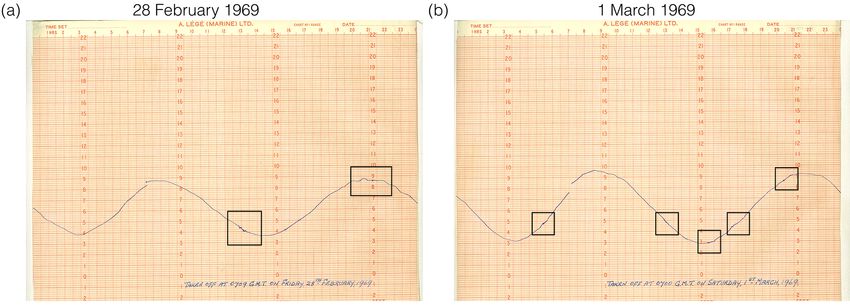
734 L. O’Brien et al.: Extreme wave events in Ireland
another significant earthquake and tsunami near Lisbon on 3.1.12 1932: Inishowen, Co. Donegal (T12)
28 February 1969. The tide gauge recordings at Belfast har-
bour show small oscillations which may be the arrival of this The description of this event indicates that more likely it was
tsunami; see Fig. 2. In addition, another tide gauge recording a storm surge, not a meteotsunami. In particular the “violent
has been located for the 1975 tsunami. The recording is taken gales” and tide rising to a height “not seen for very many
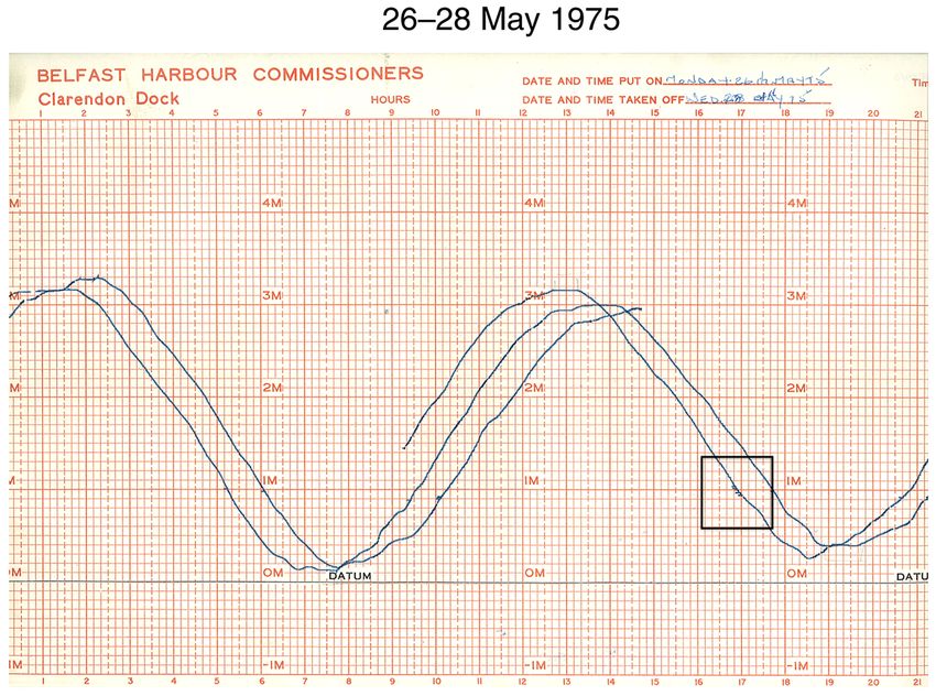
at Belfast harbour and is shown in Fig. 3. years” would correspond to a storm surge.
3.1.9 1841: Kilmore, Co. Wexford (T5) 3.1.13 2011: largest wave ever recorded in Ireland
(R13)
O’Brien et al. (2013) only had information about this event
from the RAS Historical Tsunami Database, which listed it On 13 December 2011 the M4 weather buoy registered a
as a questionable tsunami. However, another reference has 20.4 m wave which was the largest wave ever recorded by
come to light with a description of what occurred at Kil- the buoy network to date, but this record has since been bro-
more on 12 September 1841 (Milne, 1844). “The attention ken.
of the inhabitants was attracted about noontime, to a number The Kinsale Energy gas platform recorded a maximum
of short, loud, but rather smothered reports, like cannons, and wave height of 25 m on 12 February 2014 during a severe
it was supposed that they proceeded from some ship bewil- windstorm (Met Éireann, 2016a). In addition, a 26.1 m wave
dered by the fog. The tide had flown pretty well at the time, was recorded here during Storm Ophelia on 16 October 2017
and the fishing boats in the pier were all afloat, when, in a (Met Éireann, 2017).
space of two or three minutes, the water receded from the Moreover, in 2016, Storm Jake hit Ireland with severe
pier, and some walked dry shod where the short pace before winds of up to 133 km h−1 on 2 March, and a 30.96 m wave
the boats had been floating in five or six feet of water. In the was recorded at 00:30 on the wave buoy Belmullet Berth B
course of a few minutes the waters began to return, much in (Fig. 16). This could be interpreted as a suspicious reading
the same way as they had receded, and the tide continued to given how big it is, but the nearby wave buoy Belmullet Berth
rise for the usual time. There was no extraordinary commo- A also recorded a 26.35 m wave at 03:30 (Fig. 16), indicat-
tion, only an increased surf. After repeated rolls in thunder, ing that there were very large waves in the region. Since the
and some heavy showers, the sky cleared up. It is the be- buoy network was only set up in November 2000, it is not
lief generally that this singular motion was the effect of an surprising that the record has been broken since 2011.
earthquake, whose shocks have of late been so frequently ex- In addition, analysis of a wave rider buoy at Killard (off
perienced in Scotland.” The recession and return of the tide the W coast) identifies a 33.96 m wave on 26 January 2014
in such a short period of time would suggest that this was at 22:30 (Fig. 13). Again, this could be interpreted as a sus-
definitely a tsunami, but it is not clear what caused it. The picious reading and we do not accept this as the largest wave
weather preceding the wave is described as “a misty dark recorded in Ireland. However, it is worth noting that the M4
day, with the wind SSW to S . . . the low growel (sic) of dis- buoy (off the NW coast) recorded a wave of 23.44 m on the
tant thunder was heard, and the wind lulled, which rendered afternoon of the same day.
the fog more dense”. This might suggest a meteorological
origin, but this is only speculation.
4 New events up to 2012
3.1.10 1854: Kilmore, Co. Wexford (T6)
4.1 Storm waves
A map depicting the tsunami at Kilmore Quay on 16 Septem-
ber 1854 has come to light since the publication of O’Brien 4.1.1 1588: Spanish Armada
et al. (2013); see Fig. 4.
The Spanish Armada, consisting of 130 ships and 29 450
3.1.11 1909: Westport Quay, Co. Mayo (T9) men, were driven off-course by bad weather during their at-
tempt to return home through North Atlantic after their ef-
O’Brien et al. (2013) likened this event to the 2011 mild fort to conquer Protestant England. Twenty-four ships were
tsunami that occurred on the south-west coast of England be- wrecked off the Irish coast from Antrim in the north to Kerry
cause of the similar indictions of static in the air. The 2011 in the south (O’Hara, 2013).
event was originally reported as a probable meteotsunami.
However, since then it has been reported that the 2011 event 4.1.2 1895: Dun Laoghaire
was likely caused by an underwater landslide (BBC News,
29 June 2011). Fifteen men in a lifeboat lost their lives on 24 December
Therefore, it is still not clear what caused the 1909 1895 when they were called to rescue a Finnish vessel, SS
tsunami-like wave in Westport, but an underwater landslide Palme, which had run aground in Dublin Bay. This is the
or meteorological influences are likely factors. worst tragedy to have occurred in the history of the Royal Na-
Nat. Hazards Earth Syst. Sci., 18, 729–758, 2018 www.nat-hazards-earth-syst-sci.net/18/729/2018/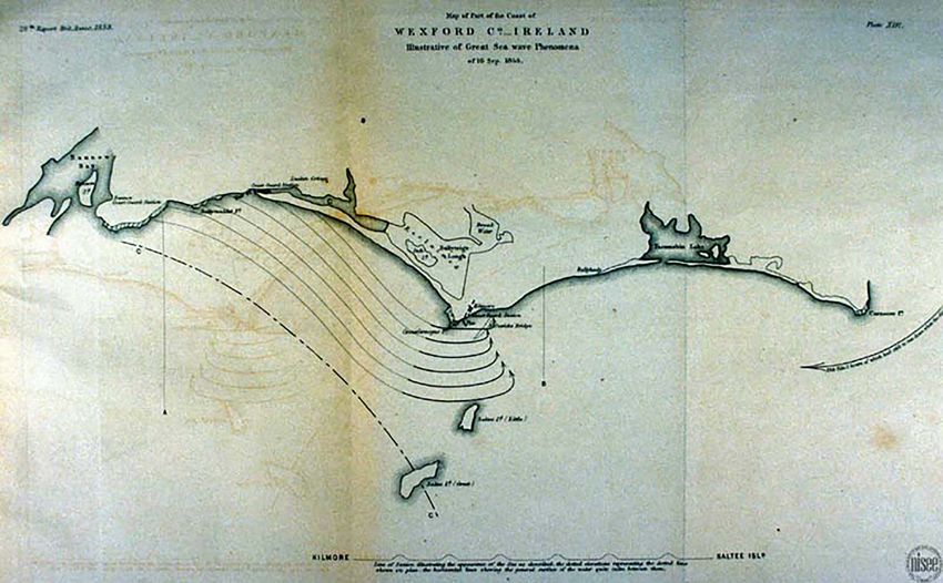
L. O’Brien et al.: Extreme wave events in Ireland                                                                                    735

Figure 2. Tide gauge recordings at Belfast harbour on (a) 28 February 1969 and (b) 1 March 1969. Minor oscillations can be seen upon
close inspection (black boxes), with the first wave arriving at approximately 13:00. Retrieved through personal contact with the Permanent
Service for Mean Sea Level (2016) (Holgate et al., 2013).

Figure 3. Tide gauge recordings at Belfast harbour 26–28 May 1975. Minor oscillations can be seen upon close inspection at approximately
17:00. Retrieved through personal contact with the Permanent Service for Mean Sea Level (2016) (Holgate et al., 2013).

tional Lifeboat Institution (RNLI). High winds, rainstorms             Two lifeboats were sent to rescue the crew and as the first
and flooding occurred across the country throughout De-                approached the ship it was hit by a huge wave and capsized.
cember, culminating in ferocious gales in the final week of            The ship’s crew attempted to launch one of their boats to
the year with nine ships wrecked on shore or sunk at sea.              rescue the men but it was smashed against the ship’s side
The SS Palme left Liverpool on 18 December and immedi-                 in heavy seas. The second lifeboat also capsized twice and
ately battled gales while attempting to head south for many            lost half her oars but righted and the crew managed to get
days without making much headway. On the morning of 24                 to safety at Blackrock. Thirteen of the rescue crew’s bodies
December the captain, with an exhausted crew, decided to               were washed up on Christmas Day and the other two sev-
make a run for Dublin Port. However, as the visibility wors-           eral days later. They included a father and son and two pairs
ened and they battled constant rain squalls, they headed for           of brothers and left a total of 34 children fatherless. Aston-
Kingstown (Dún Laoghaire) Harbour but were unable to nav-              ishingly, all 19 people aboard the ship were saved when the
igate to safety so let their anchors go outside the West Pier.         weather abated on 26 December (Louth, 2005).

www.nat-hazards-earth-syst-sci.net/18/729/2018/                                  Nat. Hazards Earth Syst. Sci., 18, 729–758, 2018
736                                                                         L. O’Brien et al.: Extreme wave events in Ireland

Figure 4. A tsunami at Kilmore Quay on 16 September 1854 (Mallet and Mallet, 1854).

   There is a memorial to the crew at Dún Laoghaire shown           when the storm suddenly blew up and their boats were driven
in Fig. 5.                                                          against the rocks. Ten people from Inishkea Islands, 9 people
                                                                    from Inishbofin and 26 fishermen in Cleggan Bay also lost
4.1.3   1903: storms across Ireland                                 their lives (Met Éireann, 2016a).

The period ending February 1903 was very stormy with de-
pressions from the Atlantic bringing very unsettled weather
                                                                    4.1.5   1935: Arranmore boat disaster
across Ireland. The night of 26 to 27 February was probably
the most severe storm since the Night of the Big Wind, 1839
(Met Éireann, 2016a). On 26 February, the Lady Disdain, a
                                                                    On 9 November 1935, a small boat carrying 20 people from
25 ft yacht, was wrecked in Valentia harbour, Co. Kerry, on
                                                                    Burtonport harbour, Co. Donegal, to Arranmore Island hit
its journey from Kingstown (Dun Laoghaire) to Nenagh. On
                                                                    rocks and sank. There was only 1 survivor, and among the
this day “there burst on the bay the hurricane which swept the
                                                                    casualties were 12 people under 30 years of age and 7 from
whole of Ireland”. At about 16:00 “the great wind came on”
                                                                    the same family. Many were returning from Scotland after
and “great waves rode down the harbour tossing the biggest
                                                                    picking potatoes for the season. Although the accident re-
vessels like cockieshells”. It was driven ashore and struck
                                                                    portedly occurred in a heavy swell, the cause was due to the
rocks (The Irish Times, 5 March 1903). Also associated with
                                                                    boat hitting rocks. It is therefore unlikely that this can be at-
this bad stretch of weather was the drowning of a 9-year-
                                                                    tributed to a wave. However, the stretch of sea is known for
old boy at Portrush, Co. Antrim, while he was on a patch of
                                                                    being treacherous, and 15 people died in three other incidents
strand beneath the promenade. It was windy and the waves
                                                                    over the same area (The Irish Times, 11 November 1935;
“frequently at long intervals” swept over the rocks and sand.
                                                                    RTÉ (2016c): 50th Anniversary of Arranmore Boat Disaster
The boy’s cap blew off and when he went to get it a “tremen-
                                                                    1985).
dous sea broke into the inlet, knocking him against the rocks,
and on receding carried him out with it” (The Irish Times, 28
February 1903).
                                                                    4.1.6   1965: Achill Island
4.1.4   1927: major storm off the west coast of Ireland

On 28 October 1927 a major storm swept across the northern          A 37-year-old farmer was swept out to sea by huge waves
half of Ireland and Britain and took the lives of 45 people         during a storm while he was beachcombing with friends
at sea. Nine fishermen drowned at Lacken Bay, Co. Mayo,             (Irish Independent 19 January 1965).

Nat. Hazards Earth Syst. Sci., 18, 729–758, 2018                             www.nat-hazards-earth-syst-sci.net/18/729/2018/
L. O’Brien et al.: Extreme wave events in Ireland                                                                                737

Figure 5. Granite memorial on the old lifeboat station wall, Dun Laoghaire (Hohenloh, 2009).

4.1.7   1975, 1976: off Rathlin O’Birne Island, Co.                   reported to have contributed to the accident (The Irish Times,
        Donegal                                                       1 August 1983).
                                                                         An RTÉ documentary (RTÉ, 2016b) suggests that a strong
On 7 January 1975, after leaving Burton Port, the Evelyn              coastal current, a subterranean river and a turning tide com-
Marie fishing trawler was hit by a wave and smashed up                bined to create treacherous conditions. After the tragedy, the
against the reef off Rathlin O’Birne Island. The boat split           superintendent at Doolin Garda (police) station warned peo-
in two and all six onboard lost their lives. On 23 November           ple that the beach had a drastic drop of about 40 ft (12.2 m)
1976, another fishing trawler, the Carraig Úna, was lost in           which could not be seen even when the tide was partially in.
very similar circumstances to the Evelyn Marie off Rathlin            He also mentioned severe undercurrents and shifting sands
O’Birne. All five crew members died (RTÉ, 2016a).                     (The Irish Times, 3 August 1983).

4.1.8   1981: off Killybegs, Co. Donegal                              4.1.10    1991: storm

On 1 November 1981 the fishing trawler, the Skifjord, was             From 20 December 1990 to 7 January 1991 vigorous de-
battered by a sudden storm and a “mighty wave” wedged the             pressions moved eastwards to the north of Ireland, bringing
boat up against a reef. The sturdy vessel was “smashed open”          strong winds across Ireland (Met Éireann, 2016a). Numerous
and the boat sank, leaving five of the nine crew members              rescues by the RAF Sea King helicopter took place including
dead (RTÉ, 2016a).                                                    a rescue of crew members on board a sinking fishing vessel
                                                                      after a wave split her hull (The Irish Times, 28 December
4.1.9   1983: the Doolin Drownings, Co. Clare                         1990). A tanker also sank in the Irish Sea after being battered
                                                                      by winds (The Irish Times, 7 January 1991). Rocks, boulders
On 31 July 1983, the second day of the Lisdoonvarna music             and waves caused huge damage on Arranmore, off Co. Done-
festival, eight men aged between 17 and 30, including three           gal. Large areas of farmland were destroyed by “hundreds of
brothers, drowned at Trá Latháin beach. At about 16:30 about          tons of rocks washed ashore by the fury of the seas”, an exca-
12 people went swimming off the Doolin beach and got into             vator was required to clear huge boulders off Chapel Road,
trouble. There were warning signs at the beach entrance but           while several homes were damaged by waves. Harbours at
it seems that the group had entered the beach from a differ-          Bunbeg, Magheragallon, Burtonport and Portnoo were af-
ent area and so did not know of the dangers. The cause of             fected by high tides and boats destroyed (The Irish Times,
the drownings is not clear but numerous different factors are         7 January 1991). It was reported that waves reached 12 m

www.nat-hazards-earth-syst-sci.net/18/729/2018/                                  Nat. Hazards Earth Syst. Sci., 18, 729–758, 2018
738                                                                         L. O’Brien et al.: Extreme wave events in Ireland

(40 ft) at the harbour on Tory Island, off Co. Donegal (The
Irish Times, 25 December 1990).
   A deep depression on 5–6 January 1991 brought strong
gale force winds across Ireland. Met Éireann reported that
although there were no wave observations, a reliable wave
model predicted a significant wave height of 13–15 m in deep
water off the west coast. Given this prediction they said it was
reasonable to expect that individual waves reached 25–30 m
(Met Éireann, 2016a).

4.1.11   1998: extreme storms

Severe weather hit Ireland and Europe on 4 January 1998,           Figure 6. Wave recorder trace taken on 12 January 1969 (Fig. 1 in
causing major disruption to ferry and airline services, and        Draper (1971))
the rescue of 10 fishermen from their sinking trawler approx-
imately 300 km south of Castletownbere, Co. Cork. They
were under tow after their engine failed, and when the tow         4.2     Rogue waves
rope broke they were “at the mercy of the huge seas” in
“force 11 gales” (103 − 117 km h−1 ). The rescue helicopter        4.2.1    1962: off Co. Cork
captain said he had “never seen anything like the conditions”
                                                                   On 9 March 1962, a Spanish fishing vessel, Maria Somenque,
with waves up to 70 ft (21 m) high covered by “20 ft (6 m)
                                                                   had the “entire front structure of the wheelhouse torn from
of mist” because the wind was so strong (The Irish Times, 5
                                                                   its foundation” by a “freak wave” (The Irish Press, 10 March
January 1998).
                                                                   1962).
4.1.12   1999: Kilkee, Co. Clare
                                                                   4.2.2    1969: off Co. Cork
On 28 December 1999 a young woman was swept into the               Draper (1971) shows a record from 12 January 1969 taken
sea at Kilkee, Co. Clare, while out walking with friends. It is    by the Commissioners of Irish Lights (CIL) with a shipborne
unclear whether this event should be categorised as a storm        wave recorder on light vessel Daunt off Cork showing a wave
wave or storm surge since it occurred at the same time as          that is 4.1 times the average wave height. Given that the av-
there was significant flooding. However, we include it as a        erage wave height would usually be around 0.63 times the
storm wave (Sunday Independent, 2 January 2000).                   significant wave height, this wave would be approximately
                                                                   2.6 times the significant wave height. See Fig. 6.
4.1.13   2005: Doolin, Co. Clare
                                                                   4.2.3    1994: bridges of Ross, Co. Clare
Three men died on 31 October 2005 when the car they
were sleeping in fell off a cliff into the sea at Doonagore        Professor Paul Wignall from the University of Leeds gave
Bay, Co. Clare. Newspaper reports suggest that they may            an eyewitness account (email communication) of a possible
have accidentally knocked the car out of gear while sleep-         rogue wave event that occurred at the Bridges of Ross, Co.
ing, but we will never know what actually happened. Gale           Clare, in March 1994 while on a field trip: “the wave was
force winds and a high swell hampered search operations            6 ft (1.8 m) higher than the highest part of the Bridge of Ross
(The Irish Times, 4, 8, 10 November 2005).                         which would make it approx 60 ft (18 m) higher than typical
                                                                   sea level height. It was quite a stormy/choppy day . . . People
4.1.14   2006–2007: Kilpatrick, Co. Wexford                        . . . on the bridge . . . thought the wave would reach them and
                                                                   started to run across the field behind . . . the wave actually
During the winter of 2006–2007, storms caused about “15 m          broke into the gully in front of the ridge. I saw the wave a
of coast collapse into the sea” including a section of an access   couple of seconds before it struck and it was a vertical wall
road to local houses. The road has not yet been repaired and       of water rather than a typical breaking wave. I’ve been back
coastal erosion in this area continues to occur. While some        several times . . . and no wave has come close to that one – a
locals would like protection from coastal erosion put in place,    pretty memorable event.”
it is a tricky situation as the region is also a Special Area
of Conservation, home to sand martins, a protected species         4.2.4    2006: Tullig Point, Co. Clare
of bird. Coastal erosion continues in the region with more
recent storms (The Wexford People, 18 August 2010; The             On 29 October 2006 a man and his friend were swept into
Irish Times, 14 January 2014).                                     the sea by a wave while fishing off rocks near the village of

Nat. Hazards Earth Syst. Sci., 18, 729–758, 2018                             www.nat-hazards-earth-syst-sci.net/18/729/2018/
L. O’Brien et al.: Extreme wave events in Ireland 739
Cross (near Kilkee), Co. Clare. While his friend managed to a level, though usually not harmful to human life, can in-
reach safety within minutes, unfortunately he drowned (The deed damage houses and electric grids and interrupt business
Irish Times, 31 October 2006 and 23 December 2006). and transport services, usually causing large financial losses
in relief and reconstruction costs. As an example, Insurance
4.2.5 2006: Blue Pool, Co. Clare Ireland recently announced that the estimated cost of claims
relating to storm damage and flooding in December and early
A Latvian man died when he was swept into the sea by a January 2014 is approximately 46 million euros (Insurance
wave while fishing at Blue Pool, between Kilkee and Doon- Ireland, 2014).
beg, Co. Clare, on 5 November 2006 (The Irish Times, 5 The dataset was extrapolated from the historic storm surge
November 2006). archive published in the Irish Coastal Protection Strategy
4.2.6 2007: Lettermore, Connemara Study (ICPSS) by the Office for Public Works (The OPW and
RPS, 2013). In that study, the Irish coastline was originally
A man was swept out to sea by a “freak wave” as he was divided into six areas, namely north-east (NE), south-east
tending livestock near Lettermore, on the Connemara coast, (SE), south (S), south-west (SW), west (W) and north-west
on 3 January 2007 (The Irish Times, 3 January 2007). (NW). For each area, the ICPSS reports a number of storm
surge events together with the relevant water level records
4.2.7 2007: Blue Pool, Co. Clare obtained from local gauges. By cross referencing the ICPSS
archive with technical reports issued by county or city coun-
On 1 July 2007 a Moldovan man was killed after he was cils found on the National Flood Hazard Mapping portal (The
washed from the rocks at Blue Pool, between Kilkee and OPW, 2016) or newspaper articles obtained from the Irish
Doonbeg, Co. Clare, by a “rogue wave”. The newspaper re- Newspaper Archives, we identified those storm surge events
port notes that this spot is “notorious for freak waves”, citing that generated coastal flooding in excess of 0.5 m.
the 2006 incident also at Blue Pool and the 2006 Tullig Point Note that the table includes events prior to 1967 and af-
incident, which is nearby (Irish Independent 2 July 2007). ter 2005 since the assessment period varies between re-
ports (S: 1967–2006; SE and NE: 1959–2005; SW, NW and
4.2.8 2009: West Cork
W: 1959–2009).
A man and his son vanished while fishing near Coominches, Inland areas can also be affected by storm surges, for in-
Co. Cork, on 12 July 2009. The cause of their disappearance stance if an area is connected to the ocean by an estuary or
is unknown. The body of the man was recovered (Break- river. Therefore, some inland flooding events have been in-
ingNews.ie, 15 July 2009). cluded as coastal flooding events in this paper. These are re-
stricted to events within ∼ 10 km of the coast. It is also im-
4.2.9 2010: Ardfield, Clonakilty, Co. Cork portant to note that there are many storm surge events that
have reports of major coastal flooding associated with them,
A man died after fishing by the rocks of a bay near Ardfield, but no inundation depths are reported; this is particularly true
Co. Cork, on 16 August 2010. Superintendent Pat Maher said in earlier years. Therefore, there may be storm surge events
conditions were misty at the time of the incident and that it that caused coastal flooding in excess of 0.5 m that are not
was highly likely he had either been swept into the water by a included in this catalogue due to a lack of available informa-
wave or had lost his footing on the rocks while fishing (Irish tion.
Examiner, 19 August 2010). Between 1961 and 2006 we identified 40 periods where
coastal flooding was generated in Ireland; this is nearly an
4.2.10 2011: Ross Bay northern shore of Loop Head average of 1 per year. It is interesting to note that all but two
Peninsula of the periods occurred between late autumn (October) and
early spring (March). The inundation levels associated with
In May 2010 a man swept from rocks while fishing at Ross
the storm systems of Table 3 vary from the threshold level of
Bay on the northern shore of Loop Head Peninsula (Irish Ex-
0.5 m to a couple of metres. Sources were scored according
aminer, 27 August 2011).
to their reliability, from A to C. A level A source is an official
4.3 Storm surges technical report, while level B indicates a report in a newspa-
per article and a level C source is an eyewitness account in a
4.3.1 1967–2005: storm surges that caused coastal newspaper article.
flooding
4.3.2 1942: Co. Kerry
Table 3 shows the historic major coastal flooding events
across the Republic of Ireland, in the period 1967–2005. A A severe storm swept over Co. Kerry during the week of 12
major coastal flooding event is defined here as an inunda- December 1942 with the “highest seas since 1928”. Many
tion in excess of 0.5 m of an otherwise dry coastal area. Such boats were destroyed and the storm was described as what
www.nat-hazards-earth-syst-sci.net/18/729/2018/ Nat. Hazards Earth Syst. Sci., 18, 729–758, 2018740 L. O’Brien et al.: Extreme wave events in Ireland
Table 3. Coastal flooding in excess of 0.5 m: 1961–2005 in the north-east (NE), south-east (SE), south (S), south-west (SW), west (W),
north-west (NW). The reliability of sources are labelled from A to C, where A indicates an official technical report, B indicates a report in a
newspaper article, and C is an eyewitness account in a newspaper article. Note that dates are given in the format day/month/year.
Flood date Region Location Inundation Source Reliability
22/10/1961 NE Glin, Limerick 1.2 m The Kerryman B
24/10/1961 W Kinvarra, Galway 1.8 m Connacht Tribune B
W Galway city and Salthill 1.2 m Connacht Tribune B
07/03/1962 NE Quay Street Dundalk, Louth 0.6 m The Irish Press B
NE Boyne Road Drogheda, Louth 0.6 m The Irish Times B
SE Main St, Wexford 0.6 m The Irish Press B
17/11/1963 NE Clontarf, Dublin 0.6 m The Irish Press B
22/12/1968 SW Ballynacally – Ennis Road 1.2 m Irish Independent B
02/02/1972 S The waterfront and railway line, Wexford 0.6 − 1.2 m Irish Independent B
and The Irish Press
S The quayside, Waterford 0.6 m Irish Independent B
SE Strand Road, Bray, Wicklow 0.9 m The Irish Press B
08/01/1974 S Bridgetown, Wexford 0.6 m Cork Examiner B
10–11/01/1974 W Road at Clogher, near Belmullet 1.2 m Connaught Telegraph B
10–11/01/1974 NW Caltragh, Sligo 1.5 m Sligo Champion C
10/01/1974 S Cork city 0.9 m The Irish Press B
10/01/1974 S Cobh, Cork 0.6 m The Irish Press B
10/01/1974 S Waterford city 0.6 m The Irish Press B
11/01/1974 S Ballinacurra, Cork 1.2 m Cork Examiner C
12–13/01/1974 W Frenchville, Galway ≥ 0.6 m Connacht Sentinal B
11/11/1977 W Galway city 0.6 m The Irish Press B
12–13/12/1981 S Timoleague – 0.9 m The Southern Star B
Courtmacsherry Road
13/12/1981 NE Clontarf road, Dublin 1.2 m The Irish Press B
13/12/1981 SE Bray, Wicklow 1.2 m The Irish Press B
14/12/1981 SW Limerick city 0.9 m Cork Examiner B
18/12/1983 S Clonakilty, Cork 0.6 m Cork Examiner B
07/04/1985 S Cork city 0.9 m Irish Independent B
04/12/1986 NW Rossbeg, Donegal ≥ 0.6 m Mayo News B
21/10/1988 S Cork – Killarney Road 0.6 m Cork Examiner B
01/03/1989 SW Spanish Point, Clare and 1.2 m Irish Independent B
08–09/03/1989 W Spanish Parade, Galway 0.6 m Galway City Tribune B
09/03/1989 SW Fivemile Bridge and 0.6 m Cork Examiner B
Castlecountess – Ballymullen Road, Kerry
14/12/1989 NE Blackrock and Salthill train stations, Dublin 0.6 m Irish Independent B
25/08/1992 NW Derrybeg, Donegal 1.5 m Donegal News B
25/08/1992 NW Annagry, Donegal 0.9 m Donegal News C
17/01/1995 SW Limerick city 0.6 m Limerick Leader B
W Claddagh, Galway 0.6 − 0.9 m Connacht Tribune B
W Grattan Park, Galway 0.9 m Galway City Tribune B
10/01/1997 W Galway city ≥ 0.6 m Connacht Sentinal B
09/02/1997 SW Corbally, Limerick 0.9 m Limerick Leader B
10/02/1997 W Galway city ≥ 0.6 m Connacht Sentinal B
04–08/01/1999 W Achill Island, Mayo 0.5 m Irish Examiner B
01/02/2002 SE New Ross, Wexford ≥ 0.6 m Irish Independent B
SE Bray, Wicklow 1m OPW A
NE Stella Gardens, Dublin 2.1 m Dublin City Council A
SW Quilty, Clare 2.1 m Office of Public Works (eyewitness account) C
SW Ballylongford, Kerry 0.9 m Office of Public Works A
NE Mornington District, Drogheda 0.6 m Office of Public Works A
NE Marsh South, Dundalk 0.5 m Office of Public Works A
21/11/2002 S Blackpool and Togher, Cork 0.6 − 1.2 m Irish Examiner B
21/11/2002 S Cork city ≥ 0.6 m Irish Independent B
27/10/2004 SE Wexford Quays 1.2 m Wexford County Council and The Irish Times A
S Crosshaven Road, Cork 1.6 m Cork City Council A
S Dungarvan, Waterford 1.5 m The Irish Times and Irish Independent C
S Dunmore East, Waterford 1.5 m The Munster Express B
S Cork (city) and Carrigaline 1.2 m Irish Examiner B
S Waterford city 0.9 m Irish Examiner B
S Dungarvan, Waterford ≥ 0.6 m Irish Examiner B
11/01/2005 SE Tralee, Kerry ≥ 0.6 m The Kerryman North Edition B
03/12/2006 W Crossmolina, Mayo 0.9 m Irish Independent B
Nat. Hazards Earth Syst. Sci., 18, 729–758, 2018 www.nat-hazards-earth-syst-sci.net/18/729/2018/L. O’Brien et al.: Extreme wave events in Ireland 741
may be “the worst ever experienced”, with flooding and the The ICPSS (The OPW and RPS, 2013) do not include this
sea walls being “completely demolished”, “badly breached” event in their reports, but there was clearly significant coastal
or “washed way”. One house was flooded with seawater flooding associated with it. Therefore, flooding in excess of
0.6 m (2 ft) deep. A well-known landmark, a large rock, dis- 0.5 m is shown in Table 4 in the same format as Table 3.
appeared. The lighthouse lamp was put out by huge seas and
high winds. Large quantities of seaweed were strewn across 4.3.5 1974: storms
the streets and the beaches were covered with fish. Damage
to fishing boats and nets were caused by “mountainous seas The weather in January 1974 was mild, wet and stormy as
and very high tides”. the North Atlantic and a large section of north-western Eu-
It was believed that sheep were blown off the cliffs in one rope was under a “sway of complex low pressure area”. An
area, while it was reported that a “tidal wave” washed 7 cattle extreme storm on 11–12 January caused extensive damage.
and 60 sheep off an island near the Derrynane coast. There In particular full moon spring tides combined with wind and
was a narrow escape by a 73-year-old man who swam to low pressure caused damage to low-lying coastal farms and
safety in Kenmare Bay when his boat was swept from her houses: “Roads were blocked by seaweed, rocks or other de-
mooring and smashed into pieces. Unfortunately his little bris and in some sections destroyed”. Many small boats sank
dog was found with the wreckage the following day (The and larger boats were torn from their moorings. At Inisboffin,
Kerryman, 19 December 1942). off Donegal, waves were sweeping through the centre, cut-
The description of high tides and tidal wave suggests that ting it in two temporarily. Also, a “freak event” at Crushoa,
this event was a storm surge. in south Galway, occurred on the evening of 11 January. Sea-
weed farmers noticed the tide “reversed for about an hour and
4.3.3 1961: Hurricane Debbie, west of Ireland then returned with full force and vigour not discernable in its
earlier movement” (Met Éireann (2016a); Connacht Tribune,
The centre of Hurricane Debbie passed close to the west 18 January 1974).
coast of Ireland on 16 September 1961, bringing winds gust- The descriptions given here imply that this event was a
ing over 171 km h−1 (110 mph). There was extensive dam- storm surge.
age to property, with 11 deaths attributed to the storm (Met
4.3.6 1976: storm
Éireann, 2016a), while newspapers reported 15 deaths (Irish
Independent, The Irish Times, 18 September 1961). A storm on 2 January 1976 caused widespread damage in
A French weather ship reported wind of 114 mph Ireland. A depression intensified considerably off the north-
(183 km h−1 ) and 45 ft (13.7 m) waves in the Aran Islands ern coast of Ireland taking people by surprise and generating
region. Seven small craft were sunk at their moorings at the storm force winds in many areas. At Limerick, the tide was
Galway docks and one swept away (Connacht Tribune, 23 just 7.6 cm short of its record level (68.6 cm). The coastal
September 1961). At Lough Sheelin, Kilnaleck, boats were town of Ballina, Co. Mayo, reported flooding, though it is not
carried inshore, some as far as 50 yards (45.7 m) (The Anglo- clear if this was coastal flooding or due to the river bursting
Celt, 23 September 1961). its banks. The sea at Kinvara, Co. Galway, “cascaded across
the quays” and the tides “swept over the road in two places”
4.3.4 1962: Youghal, Co. Cork nearly cutting off the town (Met Éireann, 2016a).
The high tides and coastal flooding clearly suggest this
A major storm caused severe high tides and flooding in was a storm surge event.
Youghal, Co. Cork, on 7 March 1962 and surrounding days.
The town was severely damaged and the sea wall collapsed. 4.3.7 1986: storms and Hurricane Charley
The waves on the beach “revealed rarely seen peat masses
. . . evidence of our past connection with Yew Trees”. August 1986 brought a succession of storms and flooding to
There was also reports of flooding and heavy seas causing Ireland. On 5 August a vigorous depression approached from
damage at Rosslare, Co. Wexford, on the train line at Wex- the south-west bringing record rainfall to Valentia, Co. Kerry,
ford town and between Greystones and Kilcoole, Co. Wick- and west Cork. In Tralee, Co. Kerry, the rain combined with a
low. Flooding and huge waves also hit Bray, Co. Wicklow, high tide caused a subterranean river under the town to flood.
and Clontarf, Co. Dublin, and caused a small landslide at At Bantry, Co. Cork, shops were in 3 ft (0.9 m) of water at
Bray Head. Heavy seas at Kilmore Quay, Co. Wexford, tore high tide.
a trawler from its moorings. At Skelligs Rock lighthouse off Just 10 days later, tropical storm Charley appeared off
Co. Kerry, a wall, railings and roadway were washed away South Carolina and intensified to a hurricane as it tracked
by “mountainous seas”. In addition, a coaster was driven north-north-east. On 18 August Charley began to decline as
ashore by strong winds and huge waves at Ards Peninsula, it headed out into the Atlantic, and by 22 August it was no
Co. Down (The Irish Times, 9 March 1962; RTÉ (2016c): more than an ordinary depression. However, the following
Aftermath of Storm Youghal 1962). day it began to deepen rapidly and by 24 August it had clearly
www.nat-hazards-earth-syst-sci.net/18/729/2018/ Nat. Hazards Earth Syst. Sci., 18, 729–758, 2018742 L. O’Brien et al.: Extreme wave events in Ireland
Table 4. Coastal flooding in excess of 0.5 m on 7 March 1962. The reliability of sources are labelled from “A” to “C”: where “A” indicates
an official technical report, “B” indicates a report in a newspaper article, and “C” is an eyewitness account in a newspaper article.
Location Inundation Source Reliability
South Terrace, Cork 2m Irish Independent B
Tragumna, Cork 2.1 m The Southern Star C
Crosshaven road, Cork 1.8 m The Southern Star B
Middleton, Cork 1.5 m The Southern Star B
Carrigaline, Cork 0.9 m Irish Independent A
and The Southern Star
Kinsale, Cork 0.9 m The Southern Star B
Bantry and Union Hall, Cork 0.6 m The Southern Star A
Waterford city 0.9 m Munster Express B
Kilshannig, Kerry 1.5 m The Kerryman C
developed into a separate depression. It tracked about 500 km 4.4.2 2011: south coast
south-west of Kerry and continued south of Ireland over the
coming days causing major flooding and damage. In fact, it The National Oceanic and Atmospheric Administration
was the worst flooding in Dublin for 100 years and described (2015) tsunami database recorded a questionable tsunami
at the time as one of the worst storms in living memory. It on 27 June 2011 in Plymouth, England, with run-up values
seems that the flooding associated with Hurricane Charley recorded at Newlyn, Plymouth, Portsmouth and St Michael’s
was associated with heavy rain rather than a storm surge (Met Mount. The tide gauge record at Castletownbere, Wexford
Éireann (2016a), The Irish Times, 6 August 1986). and Ballycotton shows evidence of this wave in Fig. 7. The
tsunami cause is given as meteorological on the NOAA
database, but a BBC News report on 29 June 2011 suggests
4.3.8 2002: Co. Dublin it was due to a submarine landslide.
Atlantic depressions brought frequent rain and gales across
the country in February 2002, causing rainfall levels to be 5 New events 2012–2016
twice the monthly normal in many parts of the country. This
led to flooding in many areas. However, a deep depression 5.1 Storm waves
that passed north-east of the country on 1 March brought
exceptionally high tides, especially in the Irish sea. Dublin 5.1.1 2014: north Co. Wexford
was most affected with its highest tide measured for over 80
years. Sea defences failed and rivers and canals burst their A storm on 13 January 2014 damaged a stretch of the North
banks causing major flooding in parts of the city (Met Éire- Wexford coastline which was described as “some of its worst
ann, 2016a). damage in decades”. In particular, a section of a house in
Ardamine was “left hanging in the air, when the cliff face
below was washed away”. In addition, part of a car park in
4.4 Tsunamis Cahore, a beach access road at Ardamine and a walking trail
in Courtown Woods were washed away. One local described
4.4.1 1942: Ventry harbour, Kerry “a high tide, and the wind in the right direction with a big
swell”, creating the very damaging conditions (The Wexford
People, 14 January 2014).
A “tsunami” was observed at Ventry harbour on a calm,
sunny day in September 1942. During a “series of huge 5.1.2 2014: west Co. Cork
waves”, “you could see the bottom of the ocean floor”. It
is said that sheep moved to higher ground before the arrival Two men died while out walking along the coastline in west
of the wave and locals were picking up fish from the fields Cork. Apparently the two men “had hoped to take photos of
after the event. The event seemed to only affect Ventry Bay stormy seas striking rocks” by a local lighthouse. The route
region and not the surrounding harbours on the other side of known locally as Poet’s Path is very exposed in parts to the
the peninsula. This might indicate that resonance occurred wind and sea. Gardaí (Irish police) assumed that freak waves
in the bay due to its shape (eyewitness account provided by and gusts of up to 130 km h−1 caused them difficulty (Irish
Dunbeg Fort and Visitor Centre). Independent, 11 February 2014).
Nat. Hazards Earth Syst. Sci., 18, 729–758, 2018 www.nat-hazards-earth-syst-sci.net/18/729/2018/You can also read