Cefn yr Ystrad (North-West) - An Archaeological Survey The Uplands Initiative
←
→
Page content transcription
If your browser does not render page correctly, please read the page content below
RCAHM Wales Uplands Initiative – Cefn yr Ystrad (North West)

                The Uplands Initiative

Cefn yr Ystrad (North-West)
               (in the southern Brecon Beacons)

       An Archaeological Survey

                             by
          Richard Hayman and Wendy Horton
                             for
                      RCAHM Wales

                      February 2007

                              1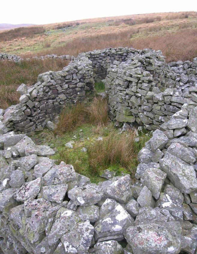
RCAHM Wales Uplands Initiative – Cefn yr Ystrad (North West)

Crynodeb

Mae arolwg ucheldir Cefn yr Ystrad (Gogledd-Orllewin) yn cwmpasu 10 cilomedr
sgwâr o dir heb ei gau ym Mharc Cenedlaethol Bannau Brycheiniog. Mae’r dirwedd
wedi’i ffinio gan gwm afon Taf Fechan ar yr ochr orllewinol, a chan Ddyffryn
Crawnon a Glyn Collwn ar yr ochr ogleddol. Mae’r adroddiad hwn yn disgrifio’r
arolwg o adran ogledd-orllewinol Cefn yr Ystrad, a gynhaliwyd yn 2006. Trefnwyd yr
arolwg drwy gerdded trawsluniau 30m rheolaidd, gyda’r nod o uniaethu safleoedd o
bob cyfnod. Cofnodwyd cyfanswm o 255 safle yn perthyn i bob cyfnod, o garneddi
Oes yr Efydd i safle cwympiad awyren yn ystod yr Ail Ryfel Byd. Pennwyd sawl
carnedd o Oes yr Efydd ar safleoedd a gawsai eu dethol yn ofalus i roi golygfa glir
dros y dirwedd amgylchynol. Gwelwyd tystiolaeth o weithgarwch Oes yr Haearn ar
ffurf anheddiad o gylchoedd cytiau a chaeadle helaeth wedi’i amddiffyn yn Y Gaer.
Credir bod dwy sarn ar draws ardal yr arolwg yn hynafol. Honnir bod un yn hen
ffordd Rufeinig, a’r llall, mae’n debyg, yn gynhanesyddol; yn agos iddi saif carreg
arysgrifedig yn perthyn i’r Canol Oesoedd cynnar. Mae’r dystiolaeth o weithgarwch
amaethyddol wedi’i chyfyngu’n bennaf i gorlannau niferus, rhai ohonynt yn
adeiladwaith cymhleth – sef, olion o’r adeg pan oedd defaid yn anifeiliaid fferm
pwysig yr oedd angen eu diadellu’n gyson ar y llechweddau agored. Cafodd calchfaen
ei gloddio er mwyn cerrig adeiladu, llosgi calch a gwneud meini melin. Pennwyd
tystiolaeth o bob gweithgarwch, gan wrthgyferbynnu ag effaith helaeth chwarela ar y
dirwedd yn ystod yr ugeinfed ganrif. Caiff yr adroddiad ei gloi drwy argymhellion ar
gyfer gwaith cofnodi ac ymchwilio yn y dyfodol.

Abstract

Cefn yr Ystrad (North-West) uplands survey covers 10 square kilometres of
unenclosed land in the Brecon Beacons National Park. The landscape is bounded by
the Taf Fechan river valley on the west wide, and on the north side by the valleys of
Dyffryn Crawnon and Glyn Collwn. This report describes the survey of the north-
west section of Cefn yr Ystrad, surveyed in 2006. The survey was conducted by
walking regular 30m transects and aimed to identify sites of all periods. A total of 255
sites were recorded of all periods from Bronze Age cairns to a World War II aircraft
crash site. Several Bronze Age cairns were identified that occupy positions carefully
chosen to offer clear views over the surrounding landscape. Evidence of Iron Age
occupation was found in the form of a settlement of hut circles and a major defended
enclosure at Y Gaer. Two trackways across the survey area are considered to be
ancient. One is said to have been a Roman road, the other is probably prehistoric and
close to it is an early medieval inscribed stone. Evidence of agriculture is largely
confined to numerous sheepfolds, some of them complex structures, a relic of when
sheep were important dairy animals and needed to be herded regularly on the open
hillside. Limestone has been quarried for building stones, lime burning and millstone
manufacture. Evidence of each activity has been identified and is contrasted with
major landscape impact of twentieth-century quarrying. The report concludes with
recommendations for future recording and research.

                                           2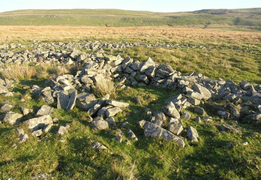
RCAHM Wales Uplands Initiative – Cefn yr Ystrad (North West)

                            Cefn yr Ystrad (North-West)
                     An Uplands Initiative Archaeological Survey

                                         by

                          Richard Hayman & Wendy Horton

© Crown Copyright, 2007

Contents

1.0   Introduction        …………………………………………………….                             4
2.0   Methodology         …………………………………………………….                             4
3.0   Results of Survey …………………………………………………….                               5
      3.1    Summary and statement of significance ………………………..             15
4.0   Recommendations …………………………………………………….                                15
      4.1    Recommendations for listing ………………….………………..                  15
      4.1    Sites under threat and recommended responses ………………..         15
      4.2    Recommendations for future work     ………………………….               15
5.0   References     ………………………………………………………….                               16
Appendix 1: Table of sites by period, altitude and type …………………….          19

List of tables

Table 1      Sites grouped by contour ………………………………………                       6
Table 2      Sites grouped by period ……………………………………….                       6
Table 3      Sites grouped by Broad Class ………………………………….                    7

List of figures

Figure1      Location plan          ……………………………………………..                     4
Figure 2     Cwm Criban trackway            ……………………………………                  8
Figure 3     Twyn Ceiliog cairn        ………………………………………….                    9
Figure 4     Enclosed farmstead on Buarth y Caerau ………………………               10
Figure 5     Sheepfold on Buarth y Caerau ………………………………..                   11
Figure 6     Lime kiln at Blaen Dyffryn Crawnon …………………………                 12
Figure 7     Twentieth-century quarrying at Cefn yr Ystrad …………….....      13
Figure 8     Estate boundary stone ………………………………………….                       14
Figure 9     Stone shelter on Pant y Creigiau     ……………………………..            14
Figure 10    Location of sites in the survey area ……………………………              18

                                         3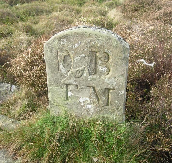
RCAHM Wales Uplands Initiative – Cefn yr Ystrad (North West)
1.0 Introduction
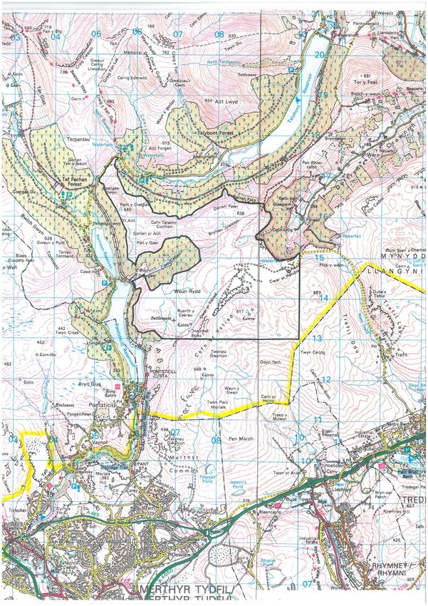
Cefn yr Ystrad is to the north of the industrialised Heads of the Valleys at Merthyr
Tydfil and is mostly within Powys and the Brecon Beacons National Park (figure 1).
It is bounded on the west by the Taf Fechan valley and to the north by Dyffryn
Crawnon and the valley of the Caerfanell brook. On the south and east sides the
terrain is flatter and merges with Mynydd Llangynidr and settlement at the heads of
the valleys. The character of the landscape is of heathland and limestone ridges with
exposed rock faces. Archaeologically the landscape can be characterised by its
prehistoric funeral monuments, low-impact agriculture and small-scale quarrying. The
only large-scale human impact is of limestone quarrying in the second half of the
twentieth century.
The Cefn yr Ystrad upland survey area has been subdivided. Only the north section,
an area of approximately 10 square kilometres within the National Park, was
surveyed. The field survey was undertaken between September and December 2006
by Hayman & Horton, with grant in aid from RCAHM Wales under the Uplands
Initiative.
Figure 1. Location plan.
2.0 Methodology
The project aimed to rapidly identify and record the archaeological resource through
systematic field survey. Archaeological remains of all periods were considered
equally. The regional Sites and Monuments Record and aerial photographs in the
4
RCAHM Wales Uplands Initiative – Cefn yr Ystrad (North West)

National Monuments Record were consulted prior to the fieldwork. In addition,
RCAHM Wales undertook historic map digitisation and aerial photograph mapping of
the area, which was consulted before and during fieldwork.

The area was divided into transects 30m apart, except in areas where remains were
sparse. These were divided into 50m transects. The location (NGR) and altitude of
every site was established by a hand-held Global Positioning System. Written
descriptions, including approximate dimensions, were made in the field. Tithe surveys
and Ordnance Surveys were consulted before and after the fieldwork, in addition to
bibliographic sources. Badminton papers at the National Library of Wales were also
consulted because part of the survey area is within the Beaufort Estate.

3.0    Results of Survey

A total of 255 sites were identified in a survey area of 10 square kilometres, giving a
density of 25.5 sites per square kilometre (figure 10). An abbreviated table of sites,
giving information on type, period and altitude, is in Appendix 1.

The survey area falls within the 350m and 650m contours and an estimate has been
made of the area in each 50m contour band (Table 1). As might be expected, the
general trend is for site density to increase as altitude decreases. The highest
topographical point is Garn Felen (617m) in the south-west quadrant of the survey
area. Around this peak, approx 0.25 square kilometres of ground is over 600m. Eight
sites, of mixed type and period, were recorded here. This is a relatively high density,
although the area may be too small to be statistically significant. In a much wider
circle around Garn Felen, the 550-600m contour band covers roughly 2 square
kilometres, much of the terrain relatively bleak and with many shake holes. In the far
north-west corner of the survey area is another peak, Pant y Creigiau (565m), but few
archaeological sites were found there. The 500-550m contour band was the most
extensive (approximately 3.7 square kilometres), covering all parts of the survey area,
and with variable terrain. Many sites in this band relate to quarrying, where
geological outcropping is a more significant factor than altitude. The greatest number
of archaeological sites (of all types and periods) was found in the next contour band,
450-500m, which is also extensive across the survey area, covering 3.1 square
kilometres. The 400-450m contour band forms a fringe around the survey area,
following the upper boundary of enclosed land, which is now mainly forestry. Many
of the sites recorded here were classed as agricultural. Four sites, all agricultural,
were found in the very small area represented by the 350-400m contour band, on the
far south-west edge of the survey area.

Post-medieval and modern periods account for 83% of the sites found in the survey.
Over 100 sites are modern, almost all of which are associated with large scale
quarrying in the latter half of the twentieth century. Post-medieval sites are divided
mainly between agricultural and industrial sites. Sites that can be ascribed to the
medieval period account for only 4% of the survey. Prehistoric sites account for just
over 10%.

                                           5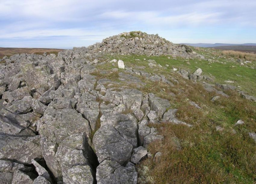
RCAHM Wales Uplands Initiative – Cefn yr Ystrad (North West)

Contour Band (m) Area (km2) No. Sites Density
                                      (per km2)

600-650                0.25        9         36
550-600                2.0         29        14.50
500-550                3.7         74        20
450-500                3.1         100       32.25
400-450                0.9         39        43.33
350-400                0.05        4         80

Total                  10          255       25.5

Table 1: Sites grouped by contour

Period            No. Sites

Bronze Age        15
Iron Age           7
Prehistoric        4
Medieval           9
Post Medieval     111
Modern            101
Unknown            7
General            1

Total             255

Table 2: Sites grouped by period

                                         6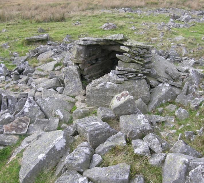
RCAHM Wales Uplands Initiative – Cefn yr Ystrad (North West)

Broad Class             No. Sites

Industrial              105
Agriculture             55
Transport               22
Religious               17
Domestic                10
Defence                  1
Recreational            24
Commemorative            2
Civil                    2
Unassigned              12
Monument by Form         5

Total                   255

Table 3: Sites grouped by Broad Class

The following synthesis is primarily a discussion by period, although not all sites lend
themselves to absolute dating. Sites range from Bronze Age to Modern and the
earliest and most recent monuments are both cairns – in the case of the latter, a cairn
and cross commemorating the crash of a Wellington bomber on a training flight in
1940 (nprn 293172).

The landscape is principally heathland. In the south-east of the survey area is a dense
concentration of sink holes that have probably inhibited human activity. Likewise
much of Waun Rydd, on the west side of the survey area, is poorly drained and
yielded few sites in the survey. Large parts of the survey area are relatively flat, with
steep terrain only at the west and north ends of the survey area. Sites identified during
the survey are concentrated in the southern half of the survey area (figure 10).

The area with the majority of the sites is traversed by two identifiably early routes across
the uplands. A track (nprn 293079) crossing the survey area in a north-east, south-west
direction might well be prehistoric, even though the earliest feature that is directly
associated with it is the Post-Roman Cwm Criban stone (nprn 92146). The track skirts a
bog and former lake at Gwaun Nant Ddu, and follows a line parallel with Cefn yr Ystrad
limestone ridge. Extensive twentieth-century quarrying destroyed a section of the track
approximately 450m long. A section near the north end is rock-cut, probably recent since it
is wide enough to allow vehicular access (figure 2). Towards the southern end it is less well
preserved because it is used illegally by motorcyclists. Another track (nprn 293076) crosses
the survey area in an east-west direction to the south of Bryniau Gleision. On the west side

                                            7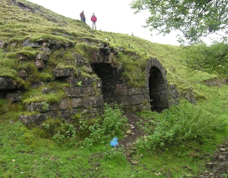
RCAHM Wales Uplands Initiative – Cefn yr Ystrad (North West)

it descends through Cwm Callan and links directly to the adjacent lowlands. Speculation
and evidence regarding the date of the track is discussed below.

                      Figure 2. Cwm Criban trackway (nprn 293079).

Bronze Age

There are 15 sites ascribed to the Bronze Age, all of which are burial cairns.
The cairns are concentrated at the southern end of the survey area, the same general area
traversed by the track mentioned above, although none of the cairns can be said to be
directly related to the track. Instead they are related to the natural topography. The altitude
of these cairns varies widely, from 447m to 618m, suggesting that the immediate setting
was more important than altitude itself; all are located with fine views over the surrounding
landscape.

The largest of the cairns, Garn Felen (nprn 305694) and Carn Bugail (nprn 305693), are
approximately 15m diameter and occupy the most prominent viewpoints. Another cairn
worthy of special mention is Twyn Ceiliog (nprn 300949), which stands just above a
prominent limestone outcrop. Post-medieval quarrying has altered the appearance of the
immediate area, but it is possible that the existence here of a limestone pavement was a
factor determining the site of the cairn (figure 3). Another possible cairn (nprn 293176) was
identified close by, also built on a limestone pavement, but so denuded that interpretation is
uncertain. Other cairns are less well preserved, such as the two on Waun Rydd (nprn
293205, 293209), where in neither case is a cist visible. Two of the cairns on Buarth y
Caerau (nprn 293219, 293221) have been disturbed by the building of shooting stands in
the nineteenth century.

                                            8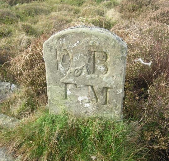
RCAHM Wales Uplands Initiative – Cefn yr Ystrad (North West)

                        Figure 3. Twyn Ceiliog cairn (nprn 300949).

Iron Age

The most significant Iron Age monument is Y Gaer Defended Enclosure (nprn 305685),
the north side of which falls within the survey area. The site does not occupy the highest
ground, but it does stand in a commanding position overlooking the Taf Fechan valley. It
may be significant that uphill of the ramparts a further natural line of defence is provided
by a line of very deep and extensive shake holes. Evidence of Bronze Age or Iron Age
settlement in the uplands is in the form of hut circles. A group of hut circles is at Buarth y
Caerau (nprn 293212, 293213, 293214, 293215, 293236), on relatively flat and well-
drained ground. Another possible hut site is close to Gwaun Nant Ddu bog (nprn 293091).

Romano-Native Period

No site could be ascribed to this period. However, there has been speculation about Roman
roads crossing the survey area. The trackway (nprn 293076), which rises out of Cwm
Callan to the west, is marked as a Roman Road on the first edition Ordnance Survey of
1890. The regional SMR notes that the road is known locally as Sarn Hir, but there is no
direct evidence of Roman origin. A number of other possible Roman roads in the area have
been recorded (CPAT Roman Roads Project, 2002-3), but again there is no direct evidence
of date. The Cwm Criban stone (nprn 92146) of the fifth or sixth century indicates that the
trackway across Cefn yr Ystrad (nprn 293079) was in use at this period.

Medieval and Post Medieval Agricultural Sites

Most of the survey area has never been enclosed, and the south-east section to the east of
Cefn yr Ystrad, is littered with sink holes and could only ever have been of marginal
agricultural value. Around the edges of the survey area are old field boundaries that show
the advance and retreat of agriculture in the uplands in the post Roman period (nprn
293001, 293070, 293183, 293241, 293022).
                                            9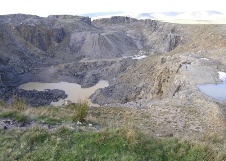
RCAHM Wales Uplands Initiative – Cefn yr Ystrad (North West)

       Figure 4. Enclosed farmstead, with footings of a building, on Buarth y Caerau
                                      (nprn 96585).

Remains of an enclosed farmstead (nprn 96585) were discovered on Buarth y Caerau, close
to the evidence of Iron Age occupation (figure 4). It has previously been interpreted as part
of the Iron Age settlement but is more likely to be later, or represent more than one phase
of occupation. The field walls have mostly collapsed, but some walls survive up to 1.3m
high. For example, the field system incorporates two pairs of animal pens (nprn 293189,
293190) at its north end, both of which are only 1.5m square in plan but have well-
preserved walls standing over 1m high, suggesting a post-medieval date. They may be pig
sties.

Several sheepfolds were discovered. Most of them are round or oval in shape, but not
exclusively so. In two cases there are multi-celled folds. On Darren Fawr is a probable fold,
comprising three contiguous square or rectangular enclosures, the smallest only 2m square.
On Buarth y Caerau is a fold (nprn 293202) comprising three rectangular and one oval
enclosure (figure 5). The dry-built walls are generally well preserved, standing up to 1.7m
high. Attached to the fold is an enclosure wall, of possibly earlier date and possibly a
forerunner to the multi-cell fold.

Most of the folds are simpler, single-cell structures and are well distributed across the
survey area (nprn 293086, 293092, 293098, 293165, 293211, 293225). Some are so small
they could never have accommodated a flock – the smallest (nprn 293227) is only 4 x 1.5m
in plan. Another small fold is defined partly by outcropping bedrock and Twyn Ceiliog
cairn (nprn 293177). Two post-medieval sheepfolds are associated with the field walls
forming the boundary of the survey area and the boundary between enclosed and
unenclosed land (nprn 293012, 293237), the latter of which is a two-celled structure inside
Dolygaer defended enclosure.

                                          10
RCAHM Wales Uplands Initiative – Cefn yr Ystrad (North West)
Figure 5. Sheepfold on Buarth y Caerau (nprn 293202).
A pillow mound was discovered on the boundary of the survey area (nprn 293082), part of
a larger complex of pillow mounds in the adjacent forestry. Some evidence was found of
rudimentary shelters that were probably built by shepherds (nprn 293226, 293175), or
might have been associated with shooting parties in the nineteenth century. Welsh
mountain ponies have been herded on the hills for a long period, but no sites associated
with them were identified.
Post-Medieval and Modern Industrial Sites
Limestone quarrying has a long history in the Cefn yr Ystrad area and many small-scale
quarry sites have been identified. These have been ascribed to the post-medieval period,
even though they have no datable features. Field stones are also plentiful in the landscape
and could easily have provided building stone for prehistoric and medieval sites mentioned
above. In 1809 Theophilus Jones described a lime burning industry on Cefn yr Ystrad that
had thrived in the later eighteenth century but had declined by the early nineteenth century
(Jones 1911, 188). He mentions several lime kilns on the unenclosed uplands, the former
existence of which is confirmed on Ordnance Survey and Tithe maps. Only one of these
kilns (nprn 293125) was positively identified, although it survives as a conical mound
without any diagnostic features visible, next to a large quarry (nprn 293124). Stone was
also quarried for mill stones and some rough-outs for mill stones have previously been
identified on the hill (Llangynidr Local History Society 2000, 28). Most of the quarry sites
are small, suggesting that they are the sporadic work of individuals or small groups serving
the local economy – quarrying stone was regarded in the eighteenth century as one of the
commoners’ rights here (NLW Badminton Papers 2329).
11RCAHM Wales Uplands Initiative – Cefn yr Ystrad (North West)
Although small-scale quarrying is concentrated at Cefn yr Ystrad and Cwar yr Hendre,
where twentieth-century exploitation was centred, there are also quarries on Bryniau
Gleision and north of Pant y Creigiau. Of the latter, there are two small quarried faces that
supplied stone for the adjacent dry stone field walls (nprn 293006, 293008). Some of the
small Bryniau Gleision quarries (nprn 293063, 293066, 293072) were probably also
associated with the building of field walls.
In 1815 the Bryn Oer Tramroad was built from near Union Ironworks, at the head of the
Rhymney valley, to the Brecknock and Abergavenny Canal at Talybont. A section of the
tramroad passes through the survey area at the head of Dyffryn Crawnon. This was
regarded as the most audacious section of the line as it followed a rock-cut ledge over steep
valley sides. The tramroad was the catalyst for a new phase of limestone quarrying,
although still on a modest scale by industrial standards. At Blaen Dyffryn Crawnon the
tramroad passed under limestone cliffs known in the sixteenth century as ‘Tarren Gwyn’
and regarded as a prominent local landmark. Although the impact of twentieth-century
quarrying here was severe, there remains evidence of quarries exploited after the opening
of the tramroad (nprn 293031, 293034, 293035, 293036, 293037). ‘Blaen Dyffryn Crawnon
lime works’ are shown on the 1832 Ordnance Survey, and must include some of the
quarries just mentioned. Owners of these quarries included Samuel Church, a Brecon
solicitor with interests in several industrial enterprises (Rattenbury 1980, 100). Messrs
Dixon and Overton, lessees of the tramroad, probably also owned quarries here and
probably built the large lime kiln (with double draw arch) facing the tramroad (nprn
293029) and roughly contemporary with it (figure 6). Another kiln from the same period
(nprn 293032) has been almost destroyed by twentieth-century quarrying – only the draw
arch is now standing. Further north and on the north side of Dyffryn Crawnon brook, is
another lime kiln (nprn 293100), but is not indicated on the 1832 Ordnance Survey or 1840
Tithe map and is therefore likely to be later.
Figure 6. Lime kiln at Blaen Dyffryn Crawnon (nprn 293029).
Limestone was not quarried from the survey area to supply the blast furnaces of the nearby
ironworks. Large-scale quarrying did not occur until the second half of the twentieth
century. There are modern quarry pits up to 40m deep (nprn 293153) and covering
12RCAHM Wales Uplands Initiative – Cefn yr Ystrad (North West)
extensive areas – Cefn yr Ystrad quarry pit (nprn 293163) is 1.1km long and up to 400m
wide, with a depth of up to 30m (figure 7). These quarries were served by an extensive road
network, partly with street lighting. Surviving quarry buildings include a well-preserved
explosives store (nprn 293102). Operations were large enough to require an electricity sub-
station on site (nprn 293108), mainly to provide power to crushing and screening plants
(nprn 293136).
Figure 7. Twentieth-century quarrying at Cefn yr Ystrad (nprn 293163).
Post-Medieval Recreational Sites
From the late nineteenth century are several sites representing the archaeology of
recreation. These sites are in clusters and associated with grouse shooting. Ownership of
the upland common land was subject to dispute in the mid nineteenth century, which is
indicated on the Llangynidr Tithe survey. A line of boundary stones is shown on the Tithe
map, but not where the extant boundary stones are found. The latter are first mentioned in
1863, in a perambulation of the Manor of Tretower conducted on behalf of the owner, the
Duke of Beaufort (NLW Badminton papers 420). These stones (nprn 293109, 203116,
293119, 293123, 293173, 293174) are inscribed with the landowners’ initials, in addition to
which is a single unhewn boulder also used as a boundary marker (nprn 293178). On one
side the stones are inscribed ‘D of B TM’, for Duke of Beaufort, Tretower Manor, which
covers the land in the south-east corner of the survey area (figure 8). The other side is
inscribed ‘GH’ for the Gwynne Holford family of Buckland Hall, Talybont. The family
owned the land in the south west of the survey area, including Cefn yr Ystrad and Buarth y
Caerau, and possibly further north as well. The double-barrelled name originated in the
early nineteenth century when the female heir of the Gwynne estate married James Price
Holford. The Buckland estate was mostly sold off in the 1920s but the hall and park was
retained by the family as a sporting estate, which probably included the unenclosed
uplands. A group of recreational sites to the west of the estate boundary line, at Buarth y
Caerau, belonged to the Gwynne Holford family. The sites comprise several shooting
stands in the form of stone walls, mostly 3-5m in length and up to 1.5m high. Two of these
(nprn 293216, 293220) are built on and caused the partial robbing out of prehistoric sites.
An unusually small cairn (nprn 293197) close to these stands, only of 2m diameter but well
formed, might be contemporary and it is tempting to interpret it as the grave of a gun dog.
13RCAHM Wales Uplands Initiative – Cefn yr Ystrad (North West)
Figure 8. Estate boundary stone (nprn 293173).
Another group of shooting stands was found near Pant y Creigiau, probably also Gwynne
Holford land. Associated with the shooting stands were several small stone shelters (figure
9). The best preserved of these (nprn 293013) is a dry-built sub-circular structure with
corbelled roof, about 1.1m diameter and 1.2m high.
Figure 9. Stone shelter on Pant y Creigiau (nprn 293013).
14RCAHM Wales Uplands Initiative – Cefn yr Ystrad (North West)
3.1 Summary and Statement of Significance
Prehistoric sites in Cefn yr Ystrad are grouped toward the southern end of the survey area,
in the area traversed by a trackway that may also be of prehistoric date and has associated
with it an early medieval Ogham stone. Cairns occupy sites with extensive viewpoints, with
the largest cairns (Garn Felen I and Carn Bugail) occupying the highest ground. Prehistoric
and medieval or post-medieval settlement is concentrated on the flatter ground of Buarth y
Caerau, at the southern end of the survey area.
There is much evidence of the use of the uplands in the local economy. Sheep folds are a
characteristic feature here and elsewhere in Wales. There has been extensive quarrying,
which is of particular interest because limestone here has been exploited mainly for a local
rural economy. Although the survey area is only five miles away from some of the largest
ironworks of the industrial period (Dowlais, Penydarren, Tredegar, Rhymney) none of
them met their demand for limestone on Cefn yr Ystrad. Although this post-medieval
quarrying landscape has been compromised by extensive twentieth-century quarrying, it
retains a distinctive character that is shared by parts of the adjoining Mynydd Llangynidr
landscape, but is quite different from other Heads of the Valleys landscapes north of
Blaenavon and Merthyr Tydfil, where there has been more extensive quarrying for an
industrial economy.
4.0 Recommendations
4.1 Recommendations for listing
No pre twentieth-century buildings were identified during the survey. The series of
boundary stones in the south east of the survey area (nprn 293109, 203116, 293119,
293123, 293173, 293174) would qualify for statutory protection. Several twentieth-century
quarry buildings were identified, but none are of special historic interest.
4.2 Sites under threat
None of the sites identified in the survey are under direct threat, except for the main tracks
across the survey area which are suffering erosion from wheeled transport, by the illegal
use of motor cycles (nprn 293079), and by the apparently legal use by off-road vehicles
(nprn 293076).
4.3 Recommendations for future work
Interpretation of the uplands archaeology is inhibited by a lack of reliable dating evidence.
Excavation is the most likely way of gaining a fuller understanding of certain site types.
These are the hut circles on Buarth y Caerau, which may be of Bronze Age or Iron Age
date; large round enclosures (nprn 290126, 290234) that have previously been interpreted
as Iron Age sites; and the enclosed settlement on Buarth y Caerau, which may be medieval,
post-medieval, or span both periods. Some of the sites on Buarth y Caerau show evidence
of later disturbance (nprn 293211) in the late nineteenth century. Excavation of selected
sites on Buarth y Caerau would provide a clearer sequence of the many phases of activity
here.
15RCAHM Wales Uplands Initiative – Cefn yr Ystrad (North West)
5.0 References
Primary Sources
National Library of Wales
Llanddeti Tithe map and apportionment, 1839
Llangynidr Tithe map and apportionment, 1840
Ordnance Survey, 1-inch series, sheet 42SE, 1832
Badminton Papers, National Library of Wales
420 Perambulation of Tretower Manor, 1863
2329 Right to quarry stone on common land, eighteenth century
Secondary Sources
Jones, Theophilus, 1911, A History of the County of Brecknock, Vol 3, Glanusk edition.
Brecon: Davies, Blissett & Co
Llangynidr Local History Society, 2000, Shadows in a Landscape: Llangynidr: The
Evolution of as Community. Llangynidr: Local History Society
Rattenbury, Gordon, 1980, Tramroads of the Brecknock and Abergavenny Canal. Oakham:
Railway & Canal Historical Society
Van Laun, John, 2001, Early Limestone Railways. London: Newcomen Society
16RCAHM Wales Uplands Initiative – Cefn yr Ystrad (North West)
17RCAHM Wales Uplands Initiative – Cefn yr Ystrad (North West)
18RCAHM Wales Uplands Initiative – Cefn yr Ystrad (North West)
APPENDIX 1
Table of sites by Period, Altitude and Type
19RCAHM Wales Uplands Initiative – Cefn yr Ystrad (North West)
NMR Analysis
NAME NPRN NGR TYPE PERIOD ALTITUDE
DOLYGAER, COPSE 293238 SO0615914330 Coppice Post Medieval 357
DOLYGAER, FIELD SYSTEM 293239 SO0614814345 Field System Post Medieval 365
DOLYGAER, FIELD BOUNDARY WALL 293240 SO0614314276 Field Boundary Post Medieval 381
DARREN FAWR, FENCE POSTS 293071 SO0816816622 Fence Modern 398
PEN BWLCH GLASGWM, PILLOW MOUND II 293084 SO0924316106 Pillow Mound Medieval 424
CWM CRIBAN, SHOOTING STAND 293184 SO0689613020 Shooting Stand Post Medieval 428
COETGAELLWYN, FIELD WALL 293000 SO0546917434 Field Boundary Post Medieval 428
DOLYGAER, Y GAER DEFENDED ENCLOSURE 305685 S005931478 Defended Enclosure Iron Age 433
CWM CRIBAN, HUT 293185 SO0693113039 Shepherd's Hut Post Medieval 434
DOLYGAER, Y GAER SHEEP FOLD 293237 SO0598914807 Sheep Fold Post Medieval 435
CEFN TARENNI COCHION, FENCE POSTS 293065 SO0733016070 Fence Modern 436
CWM CRIBAN, SHEEP FOLD I 293187 SO0696113073 Sheep Fold Post Medieval 437
CWM CRIBAN, REVETMENT 293186 SO0696713056 Revetment Unknown 437
BLAEN-DYFFRYN CRAWNON, CULVERT UNDER BRYN OER TRAMROAD 34622 SO0953614920 Culvert Post Medieval 440
WAUN RYDD, SHOOTING STAND I 293193 SO0654013305 Shooting Stand Post Medieval 441
DARREN FAWR, FIELD BOUNDARY 293070 SO0826516518 Field Boundary Post Medieval 442
WAUN RYDD, SHOOTING STAND X 293207 SO0604813417 Shooting Stand Post Medieval 442
WAUN RYDD, SHOOTING STAND II 293194 SO0651813296 Shooting Stand Post Medieval 442
WAUN RYDD, MOUND 293197 SO0647713316 Mound Unknown 442
WAUN RYDD, SHOOTING STAND XI 293208 SO0604113438 Shooting Stand Post Medieval 442
WAUN RYDD, SHEEP FOLD II 293206 SO0607313376 Sheep Fold Post Medieval 443
DARREN FAWR, QUARRY FACE II 293066 SO0780516384 Quarry Post Medieval 446
COETGAELLWYN, IRON ROD I 293002 SO0523117108 Electricity Pylon Modern 446
WAUN RYDD, SHOOTING STAND IV 293196 SO0650113345 Shooting Stand Post Medieval 447
CWAR BLAEN-DYFFRYN, QUARRY I 293031 SO0993715087 Limestone Quarry Modern 447
20RCAHM Wales Uplands Initiative – Cefn yr Ystrad (North West)
NMR Analysis
NAME NPRN NGR TYPE PERIOD ALTITUDE
DARREN FAWR, AGRICULTURAL BUILDING 293068 SO0807016433 Agricultural Building Post Medieval 447
WAUN RYDD, CAIRN I 293205 SO0625513310 Cairn Bronze Age 447
BLAEN-DYFFRYN CRAWNON, QUARRY 293101 SO0937315020 Limestone Quarry Post Medieval 447
CWAR BLAEN-DYFFRYN, SPOIL HEAPS 293026 SO1004815194 Spoil Heap Modern 448
BLAEN-DYFFRYN CRAWNON, LIME KILN 293100 SO0938215027 Lime Kiln Post Medieval 448
WAUN RYDD, SHOOTING STAND III 293195 SO0650713355 Shooting Stand Post Medieval 448
WAUN RYDD, SHOOTING STAND VI 293199 SO0645413365 Shooting Stand Post Medieval 448
WAUN RYDD, SHOOTING STAND VII 293200 SO0645413373 Shooting Stand Post Medieval 448
WAUN RYDD, SHOOTING STAND IX 293204 SO0644413368 Shooting Stand Post Medieval 449
CWM CRIBAN, PIG STIES I 293189 SO0693213422 Pigsty Medieval 450
CWAR YR HENDRE, QUARRY FACE II 293035 SO0977114937 Limestone Quarry Modern 450
COETGAELLWYN, IRON ROD II 293003 SO0537517164 Electricity Pylon Modern 450
PEN BWLCH GLASGWM, FIELD BOUNDARY 293083 SO0912616158 Field Boundary Post Medieval 450
CWM CRIBAN, SHEEP FOLD II 293188 SO0706113183 Sheep Fold Post Medieval 450
PEN BWLCH GLASGWM, PILLOW MOUND I 293082 SO0912616158 Pillow Mound Medieval 450
WAUN RYDD, SHOOTING STAND V 293198 SO0646713366 Shooting Stand Post Medieval 450
WAUN RYDD, SHEEP FOLD I 293202 SO0642813349 Sheep Fold Post Medieval 450
WAUN RYDD, ENCLOSURE 293203 SO0642813349 Enclosure Post Medieval 450
WAUN RYDD, SHOOTING STAND XIII 293231 SO0632813388 Shooting Stand Post Medieval 451
CWAR BLAEN DYFFRYN, LIMEKILN 293029 SO1000115136 Lime Kiln Post Medieval 451
CWM CRIBAN, PIG STIES II 293190 SO0694013424 Pigsty Medieval 451
WAUN RYDD, CAIRN III 293232 SO0627513354 Cairn Bronze Age 451
CWM CRIBAN, ENCLOSED SETTLEMENT 96585 SO0694613387 Enclosed Settlement Medieval 452
BLAEN-DYFFRYN CRAWNON, TRACK 293099 SO0949514899 Trackway Medieval 452
BLAEN-DYFFRYN CRAWNON, SHEEP FOLD 293098 SO0949914885 Sheep Fold Post Medieval 453
WAUN RYDD, SHOOTING STAND XII 293230 SO0640413433 Shooting Stand Post Medieval 453
21RCAHM Wales Uplands Initiative – Cefn yr Ystrad (North West)
NMR Analysis
NAME NPRN NGR TYPE PERIOD ALTITUDE
DARREN FAWR, CLEARANCE CAIRN 293067 SO0803816407 Clearance Cairn Post Medieval 453
WAUN RYDD, SHOOTING STAND VIII 293201 SO0645513397 Shooting Stand Post Medieval 454
CWAR YR HENDRE, ROAD 293028 SO1006115175 Road Modern 454
BLAEN-DYFFRYN CRAWNON, BRYN OER TRAMROAD 293027 SO1009715266 Tramway Post Medieval 455
BLAEN-DYFFRYN CRAWNON, BRIDGE OVER STREAM 293033 SO0951314879 Bridge Post Medieval 455
CWM CRIBAN, ENCLOSURE 293192 SO0693613493 Enclosure Medieval 455
CWAR YR HENDRE, COMMEMORATIVE STONE 293030 SO1005615181 Commemorative Stone Modern 456
CWAR YR HENDRE, POND WITH OUTFLOW PIPE 293054 SO0951614845 Pond Modern 456
NANT YR YCHEN, STRUCTURE 293086 SO0785415220 Structure Post Medieval 458
DARREN FAWR, QUARRY FACE I 293063 SO0825216448 Quarry Post Medieval 458
DARREN FAWR, QUARRY FACE III 293069 SO0818816418 Quarry Post Medieval 458
CWAR YR HENDRE, PATH 293040 SO0995315083 Path Modern 460
WAUN RYDD, SHEEP FOLD III 293211 SO0667113482 Sheep Fold Post Medieval 460
BUARTH Y CAERAU, HUT CIRCLE II 293213 SO0694113579 Hut Circle Iron Age 461
BUARTH Y CAERAU, HUT CIRCLE IIII 293214 SO0694113583 Hut Circle Iron Age 461
CWM CRIBAN, PONTSTICILL INSCRIBED STONE 92146 SO0726513176 Inscribed Stone Medieval 461
BUARTH Y CAERAU, HUT CIRCLE I 293212 SO0695213557 Hut Circle Iron Age 462
PANT Y CREIGIAU, FIELD BOUNDARY WALL II 293010 SO0648916091 Field Boundary Post Medieval 462
CWAR YR HENDRE, SPOIL HEAP II 293039 SO0994315067 Spoil Heap Modern 462
CWAR YR HENDRE, QUARRY FACE V 293045 SO0993715021 Limestone Quarry Modern 463
CWAR YR HENDRE, QUARRY SPOIL I 293041 SO0996715083 Spoil Heap Modern 463
CWAR BLAEN-DYFFRYN, REMAINS OF LIMEKILN 293032 SO0995215075 Lime Kiln Post Medieval 463
CWAR YR HENDRE, QUARRY FACE III 293036 SO0987015009 Limestone Quarry Modern 465
CWAR YR HENDRE, QUARRY FACE IV 293037 SO0989615033 Limestone Quarry Modern 465
BUARTH Y CAERAU, SHOOTING STAND I 293216 SO0700513561 Shooting Stand Post Medieval 465
BUARTH Y CAERAU, HUT CIRCLE IV 293215 SO0700513561 Hut Circle Iron Age 465
22RCAHM Wales Uplands Initiative – Cefn yr Ystrad (North West)
NMR Analysis
NAME NPRN NGR TYPE PERIOD ALTITUDE
CWM CRIBAN, CAIRN 305691 SO0734313320 Cairn Bronze Age 465
CWAR YR HENDRE, SPOIL HEAP I 293038 SO0987015017 Spoil Heap Modern 465
WAUN RYDD, SHED 293210 SO0659313587 Shed Modern 466
WAUN RYDD, CAIRN II 293209 SO0628213559 Cairn Bronze Age 467
BUARTH Y CAERAU, SHOOTING STAND III 293217 SO0716313554 Shooting Stand Post Medieval 468
WAUN RYDD, FIELD BOUNDARY I 293183 SO0629314156 Field Boundary Post Medieval 468
CWAR YR HENDRE, SPOIL HEAP III 293044 SO0999815016 Spoil Heap Modern 469
BUARTH Y CAERAU, HUT CIRCLE V 293236 SO0698213565 Hut Circle Iron Age 469
CWAR YR HENDRE, QUARRY SPOIL IV 293056 SO0945314780 Spoil Heap Modern 469
BRYNIAU GLEISION, FIELD BOUNDARY BANK 293023 SO0714515549 Field Boundary Post Medieval 470
CWAR YR HENDRE, QUARRY FACE VI 293051 SO0976914866 Limestone Quarry Modern 470
PANT Y CREIGIAU, FIELD BOUNDARY WALL I 293009 SO0590916522 Field Boundary Post Medieval 470
CWAR BLAEN DYFFRYN, TRACK I 293042 SO1003115031 Trackway Modern 471
CWAR YR HENDRE, QUARRY FACE I 293034 SO0972814933 Limestone Quarry Modern 471
BUARTH Y CAERAU, SHOOTING STAND V 293222 SO0706713580 Shooting Stand Post Medieval 471
CWAR YR HENDRE, TRACK III 293046 SO0987814980 Trackway Modern 471
BUARTH Y CAERAU, SHOOTING STAND II 293217 SO0709813555 Shooting Stand Post Medieval 472
GWAUN NANT DDU, FIELD BOUNDARY WALL 293088 SO0905215687 Field Boundary Post Medieval 473
CWAR YR HENDRE, QUARRY SPOIL III 293055 SO0949114783 Spoil Heap Modern 473
CWAR YR HENDRE, MACHINE BASE I 293047 SO0990115006 Machinery Modern 473
WAUN RYDD, FIELD BOUNDARY WALL 293141 SO0703814537 Field Boundary Post Medieval 474
CWAR YR HENDRE, QUARRY BUILDING I 293057 SO0956014783 Quarry Building Modern 475
BUARTH Y CAERAU, SHOOTING STAND IV 293220 SO0721013574 Shooting Stand Post Medieval 475
BUARTH Y CAERAU, CAIRN I 293219 SO0721013575 Cairn Bronze Age 475
CWAR YR HENDRE, QUARRY SPOIL II 293048 SO0990715011 Spoil Heap Modern 476
COETGAELLWYN, BOUNDARY WALL I 293001 SO0535016757 Field Boundary Post Medieval 477
23RCAHM Wales Uplands Initiative – Cefn yr Ystrad (North West)
NMR Analysis
NAME NPRN NGR TYPE PERIOD ALTITUDE
CWAR YR HENDRE, BRIDGE OVER WATERCOURSE 293059 SO0956614779 Bridge Modern 478
CWAR YR HENDRE, EXPLOSIVES STORE 293102 SO0974014736 Explosives Store Modern 478
CWAR YR HENDRE, QUARRY FACE VII 293103 SO0973514734 Limestone Quarry Modern 478
CWAR YR HENDRE, SPOIL ABOVE QUARRY FACE VII 293104 SO0973514734 Spoil Heap Modern 478
CWAR YR HENDRE, PAIR OF WEIRS 293058 SO0956614779 Weir Modern 478
CWM CRIBAN, ANIMAL SHED 293191 SO0704013404 Animal Shed Medieval 478
NANT YR YCHEN, CAIRN 293081 SO0745215486 Cairn Bronze Age 479
CWAR YR HENDRE, BUILDING PLATFORM I 293052 SO0966114853 Quarry Building Modern 479
CWAR YR HENDRE, TRACK IV 293060 SO0954114780 Trackway Modern 479
CWAR YR HENDRE, QUARRY II 293050 SO0963914867 Limestone Quarry Modern 479
CWAR YR HENDRE, QUARRIES 402616 SO086145 Limestone Quarry Modern 480
CWAR YR HENDRE, BUILDING PLATFORM II 293053 SO0959414810 Quarry Building Modern 480
CWAR YR HENDRE, BUILDING PLATFORM III 293061 SO0953814764 Quarry Building Modern 480
CWAR YR HENDRE, BUILDING PLATFORM IV 293062 SO0953514758 Quarry Building Modern 480
BLAEN DYFFRYN CRAWNON, CLEARANCE CAIRN II 293097 SO0909315081 Clearance Cairn Modern 481
BLAEN DYFFRYN CRAWNON, CLEARANCE CAIRN I 293096 SO0907415077 Clearance Cairn Modern 483
BUARTH Y CAERAU, CAIRN II 293221 SO0729613638 Cairn Bronze Age 483
NANT YR YCHEN, MOUND 293087 SO0804015447 Mound Unknown 484
PEN BWLCH GLASGWM, TRACK 293080 SO0908916320 Trackway Post Medieval 485
CWAR YR HENDRE, QUARRY I 293049 SO0978714902 Limestone Quarry Modern 485
BLAEN DYFFRYN CRAWNON, FENCE 293095 SO0906415070 Fence Modern 485
CEFN TARENNI COCHION, PATH 293064 SO0694415831 Path Post Medieval 485
CWAR YR HENDRE, BUILDING PLATFORM VIII 293157 SO0955214757 Quarry Building Modern 486
PEN Y GAER, FIELD BOUNDARY WALL 293022 SO0674615488 Field Boundary Post Medieval 487
CWAR YR HENDRE, BUILDING PLATFORM VII 293155 SO0947214702 Quarry Building Modern 488
CWAR YR HENDRE, QUARRY X 293156 SO0955014732 Limestone Quarry Modern 488
24RCAHM Wales Uplands Initiative – Cefn yr Ystrad (North West)
NMR Analysis
NAME NPRN NGR TYPE PERIOD ALTITUDE
CWAR YR HENDRE, TRACK VIII 293158 SO0952114732 Trackway Modern 489
GWAUN NANT DDU BOG 300628 SO087154 Natural Feature General 490
BUARTH Y CAERAU, SHOOTING STAND VI 293223 SO0732213776 Shooting Stand Post Medieval 492
CEFN TARENNI COCHION, PAIR OF MACHINE BASES 293025 SO0699615804 Winding Gear Modern 492
CWAR YR HENDRE, QUARRY FACE XIV 293159 SO0949914694 Limestone Quarry Modern 494
COETGAELLWYN, QUARRY FACE II 293008 SO0540716659 Limestone Quarry Post Medieval 494
CWAR YR HENDRE, PYLON BASE I 293111 SO0957014492 Electricity Pylon Modern 495
CWAR YR HENDRE, BUILDING PLATFORM V 293130 SO0894814827 Quarry Building Modern 495
CWAR YR HENDRE, SPOIL HEAP IV 293128 SO0906714883 Spoil Heap Modern 496
BUARTH Y CAERAU, SHEEP FOLD II 293225 SO0762213766 Sheep Fold Modern 496
CWAR YR HENDRE, QUARRY BUILDING II 293129 SO0897614836 Quarry Building Modern 496
GWAUN NANT DDU, CAIRN I 293089 SO0874215341 Cairn Bronze Age 497
BUARTH Y CAERAU, ENCLOSURE 293227 SO0761413822 Enclosure Post Medieval 500
CWAR YR HENDRE, PYLON BASE II 293112 SO0963314492 Electricity Pylon Modern 500
CWAR YR HENDRE, TRACK V 293107 SO0963114714 Trackway Modern 501
GWAUN NANT DDU, CAIRN II 293090 SO0882915373 Cairn Bronze Age 502
BUARTH Y CAERAU, SHEEP FOLD I 293224 SO0731713880 Sheep Fold Post Medieval 502
CWM CRIBAN, TRACKWAY 293079 SO0851915566 Trackway Prehistoric 502
BUARTH Y CAERAU, STONE 293226 SO0760013817 Stone Unknown 502
CWAR YR HENDRE, ELECTRICITY SUB STATION 293108 SO0956714677 Electricity Sub Station Modern 503
GWAUN NANT DDU, ENCLOSURE 293092 SO0833715167 Sheep Fold Post Medieval 503
CWAR YR HENDRE, BOUNDARY STONE I 293109 SO0953214675 Boundary Stone Post Medieval 504
GWAUN NANT DDU, STONE 293093 SO0834815158 Stone Post Medieval 506
GWAUN NANT DDU, HUT SITE 293091 SO0847615214 Hut Iron Age 507
CWM CALLAN, TRACKWAY 293076 SO0850815901 Trackway Post Medieval 507
CWAR YR HENDRE, QUARRY FACE XIII 293154 SO0928214683 Limestone Quarry Modern 507
25RCAHM Wales Uplands Initiative – Cefn yr Ystrad (North West)
NMR Analysis
NAME NPRN NGR TYPE PERIOD ALTITUDE
CWAR YR HENDRE, PYLON BASE III 293113 SO0972014497 Electricity Pylon Modern 507
GORLAN YR ALLT, SHEEP FOLD 293012 SO0575115621 Sheep Fold Post Medieval 508
NANT YR YCHEN, SHOOTING STAND 293094 SO0764614801 Shooting Stand Post Medieval 509
DARREN FACH, QUARRY FACE III 293075 SO0901616197 Quarry Post Medieval 510
GORLAN YR ALLT, FIELD BOUNDARY WALL 293011 SO0572215698 Field Boundary Post Medieval 510
GORLAN YR ALLT, SHELTER V 293020 SO0602115504 Shelter Shed Post Medieval 510
CWAR BLAEN DYFFRYN, QUARRY FACE I 293106 SO0983414712 Limestone Quarry Modern 511
CWAR YR HENDRE, QUARRY IX 293153 SO0901914648 Limestone Quarry Modern 511
CWAR YR HENDRE, TRACK VI 293134 SO0886014810 Trackway Modern 512
DARREN FACH, TRACK 293074 SO0902216249 Trackway Post Medieval 513
BRYNIAU GLEISION, LIMESTONE QUARRY III 293085 SO0849815929 Limestone Quarry Post Medieval 514
CWAR YR HENDRE, BOUNDARY STONE II 293116 SO0954614379 Boundary Stone Post Medieval 515
CWAR YR HENDRE, PROCESSING PLANT I 293133 SO0889014797 Structure Modern 515
CWAR YR HENDRE, CLEARANCE CAIRN 293117 SO0963614279 Clearance Cairn Post Medieval 516
CWAR BLAEN DYFFRYN, TRACK II 293043 SO1000014774 Trackway Modern 517
CWAR YR HENDRE, QUARRY FACE XII 293131 SO0889414789 Limestone Quarry Modern 517
CWAR YR HENDRE, PYLON BASE IV 293114 SO0977614498 Electricity Pylon Modern 517
NANT YR YCHEN, LIMESTONE QUARRY 293078 SO0808815444 Limestone Quarry Post Medieval 518
DARREN FACH, QUARRY FACE I 293072 SO0901016326 Quarry Post Medieval 518
CWAR YR HENDRE, QUARRY FACE VIII 293105 SO0988714720 Limestone Quarry Modern 519
CEFN TARENNI COCHION, QUARRY 293021 SO0684415830 Limestone Quarry Modern 520
GORLAN YR ALLT, SHOOTING STAND III 293018 SO0617115585 Shooting Stand Post Medieval 522
GORLAN YR ALLT, SHOOTING STAND II 293017 SO0618115591 Shooting Stand Post Medieval 522
GORLAN YR ALLT, SHELTER II 293014 SO0608715640 Shelter Shed Post Medieval 523
CWAR YR HENDRE, PYLON BASE V 293115 SO0989014501 Electricity Pylon Modern 523
GORLAN YR ALLT, SHELTER I 293013 SO0608715642 Shelter Shed Post Medieval 523
26RCAHM Wales Uplands Initiative – Cefn yr Ystrad (North West)
NMR Analysis
NAME NPRN NGR TYPE PERIOD ALTITUDE
CWAR YR HENDRE, BUILDING INC. TUNNEL II 293152 SO0887414769 Quarry Building Modern 524
CWAR BLAEN-DYFFRYN, QUARRY II 293110 SO0992314680 Limestone Quarry Modern 524
CWAR YR HENDRE, QUARRY BUILDING III 293132 SO0891014794 Quarry Building Modern 524
CWAR YR YSTRAD, QUARRY II 293229 SO0780913643 Limestone Quarry Modern 525
CWAR YR HENDRE, QUARRY BUILDING IV 293135 SO0874314787 Quarry Building Modern 525
GORLAN YR ALLT, SHELTER III 293015 SO0615115621 Shelter Shed Post Medieval 526
COETGAELLWYN, BOUNDARY WALL II 293005 SO0535116486 Field Boundary Post Medieval 526
GORLAN YR ALLT, SHELTER IV 293019 SO0616615389 Shelter Shed Post Medieval 526
CWAR YR HENDRE, QUARRY PROCESSING PLANT II 293136 SO0873314773 Structure Modern 527
CWAR YR HENDRE, BUILDING INC TUNNEL I 293151 SO0886214780 Quarry Building Modern 527
CWAR YR HENDRE, QUARRY VII 293141 SO0848514798 Limestone Quarry Modern 527
COETGAELLWYN, QUARRY FACE 293006 SO0537216492 Limestone Quarry Post Medieval 528
CWAR YR HENDRE, QUARRY IV 293138 SO0863814769 Limestone Quarry Post Medieval 528
GORLAN YR ALLT, PAIR OF SHOOTING STANDS I 293016 SO0621315615 Shooting Stand Post Medieval 528
CWAR YR HENDRE, QUARRY V 293139 SO0859114774 Limestone Quarry Post Medieval 528
CWAR YR YSTRAD, QUARRY III 293242 SO0795114220 Limestone Quarry Post Medieval 529
CWAR YR HENDRE, QUARRY VIII 293142 SO0849014769 Limestone Quarry Modern 530
CWAR YR HENDRE, MOUND 293118 SO0957514245 Mound Unknown 530
CWAR YR HENDRE, TRACK X 293162 SO0861814547 Trackway Modern 530
BRYNIAU GLEISION, LIMESTONE QUARRY 293024 SO0784515820 Limestone Quarry Post Medieval 531
CWAR YR HENDRE, QUARRY III 293137 SO0867414777 Limestone Quarry Post Medieval 532
CWAR YR HENDRE, QUARRY VI 293140 SO0853714773 Limestone Quarry Post Medieval 533
CWAR YR HENDRE, TRACK VII 293143 SO0856514731 Trackway Modern 533
CWAR YR HENDRE, CHUTE I 293144 SO0876914757 Structure Modern 535
CWAR YR HENDRE, CHUTE II 293145 SO0879614757 Structure Modern 535
CWAR YR HENDRE, BUILDING PLATFORM VI 293146 SO0878514782 Quarry Building Modern 535
27RCAHM Wales Uplands Initiative – Cefn yr Ystrad (North West)
NMR Analysis
NAME NPRN NGR TYPE PERIOD ALTITUDE
CWAR YR HENDRE, PLATFORM 293147 SO0877014795 Structure Modern 535
CWAR YR HENDRE, QUARRY XI 293160 SO0919114261 Limestone Quarry Modern 535
CWAR YR HENDRE, SHAFT 293150 SO0886614756 Shaft Modern 536
CWAR YR HENDRE, STRUCTURE II 293149 SO0884414745 Structure Modern 536
CWAR YR HENDRE, STRUCTURE I 293148 SO0879914744 Structure Modern 536
BRYNIAU GLEISION, LIMESTONE QUARRY II 293077 SO0843916085 Limestone Quarry Post Medieval 536
CWAR YR YSTRAD, QUARRY BUILDING I 293228 SO0823314231 Quarry Building Modern 538
COETGAELLWYN, CULVERT OVER WATERCOURSE 293007 SO0543016361 Culvert Post Medieval 543
CEFN YR YSTRAD, QUARRY IV 293233 SO0775312987 Quarry Post Medieval 547
CWAR-Y-HENDRE, ENCLOSURE 307693 SO092142 Enclosure Unknown 550
CWAR YR HENDRE, BOUNDARY STONE III 293119 SO0956014098 Boundary Stone Post Medieval 552
CWAR YR YSTRAD, QUARRY BUILDING II 293235 SO0796213587 Quarry Building Modern 554
CWAR YR HENDRE, TRACK XI 293161 SO0903214454 Trackway Modern 555
CWAR YR YSTRAD, TRACK I 293164 SO0870914430 Trackway Modern 560
TWYN CEILIOG, SHEEP FOLD 293177 SO0990913108 Sheep Fold Post Medieval 562
CWAR YR HENDRE, BOUNDARY STONE IV 293123 SO0953513910 Boundary Stone Post Medieval 562
CWAR YR YSTRAD, QUARRIES 293243 SO0815014000 Limestone Quarry Post Medieval 563
TWYN CEILIOG, CAIRN I 300949 SO0990813103 Cairn Bronze Age 563
CWAR YR YSTRAD, QUARRY I 293163 SO0856114251 Limestone Quarry Modern 563
CWAR YR HENDRE, QUARRY FACE IX 293120 SO0902714110 Limestone Quarry Modern 565
PANT Y CREGIAU, TRIANGULATION POINT 293004 SO0565716203 Triangulation Point Modern 565
CWAR YR HENDRE, LIME KILN 293125 SO0934413896 Lime Kiln Post Medieval 566
CWAR YR HENDRE, QUARRY FACE X 293121 SO0901314091 Limestone Quarry Modern 568
CWAR YR HENDRE, QUARRY FACE XI 293124 SO0932813893 Limestone Quarry Post Medieval 569
CEFN YR YSTRAD, QUARRY III 293182 SO0792713120 Limestone Quarry Post Medieval 573
CEFN YR YSTRAD, QUARRY II 293181 SO0794813119 Limestone Quarry Post Medieval 573
28RCAHM Wales Uplands Initiative – Cefn yr Ystrad (North West)
NMR Analysis
NAME NPRN NGR TYPE PERIOD ALTITUDE
CEFN YR YSTRAD, QUARRY I 293180 SO0802413098 Limestone Quarry Post Medieval 575
DARREN FACH, QUARRY FACE II 293073 SO0902316270 Quarry Post Medieval 576
TWYN CEILIOG, BOUNDARY STONE I 293173 SO0945113292 Boundary Stone Post Medieval 577
TWYNAU GWYNION, CAIRN 293179 SO0825612988 Cairn Bronze Age 577
TWYN CEILIOG, BOUNDARY STONE III 293178 SO0942013240 Boundary Stone Post Medieval 580
TWYN CEILIOG, BOUNDARY STONE II 293174 SO0936313154 Boundary Stone Post Medieval 581
GARN FELEN, CIRCULAR WALL 293170 SO0913013742 Wall Post Medieval 583
TWYN CEILIOG, SHELTER SHED 293175 SO0936213157 Shelter Shed Post Medieval 584
TWYN CEILIOG, CAIRN II 293176 SO0931813155 Cairn Bronze Age 589
GARN FELEN, ENCLOSURE II 293234 SO0902513791 Enclosed Settlement Prehistoric 590
CARN Y BUGAIL, MOUND 293171 SO0913113606 Mound Unknown 590
CWAR YR YSTRAD, QUARRY TRIAL EXCAVATION 293166 SO0826113842 Limestone Quarry Modern 600
GARN FELEN, ENCLOSURE I 293126 SO0889213878 Enclosed Settlement Prehistoric 600
CWAR YR YSTRAD QUARRY FACE I 293122 SO0858614026 Limestone Quarry Modern 603
GARN FELEN, CAIRN II 293168 SO0854513843 Cairn Bronze Age 605
GARN FELEN, CLEARANCE CAIRN I 293167 SO0843113849 Clearance Cairn Post Medieval 605
GARN FELEN, SHEEP FOLD 293165 SO0842213925 Sheep Fold Post Medieval 607
GARN FELEN, COMMEMORATIVE MONUMENT (WWII) 293172 SO0894813701 Commemorative Modern 609
Monument
CARN Y BUGAIL, CAIRN 305693 SO0880613629 Cairn Bronze Age 615
GARN FELEN, CAIRN III 293127 SO0882513838 Cairn Prehistoric 616
GARN FELEN, TRIANGULATION POINT 293169 SO0869913740 Triangulation Point Modern 617
GARN FELEN, CAIRN I 305694 SO0885613724 Cairn Bronze Age 618
29You can also read