Central Ground Water Board - For official use Technical Report Series
←
→
Page content transcription
If your browser does not render page correctly, please read the page content below
For official use

                  Technical Report Series

DISTRICT GROUNDWATER BROCHURE
        CHENNAI DISTRICT
           TAMIL NADU

                     By

         T. Balakrishnan, Scientist-D

        Government of India
     Ministry of Water Resources
 Central Ground Water Board
    South Eastern Coastal Region
              Chennai
          November 2008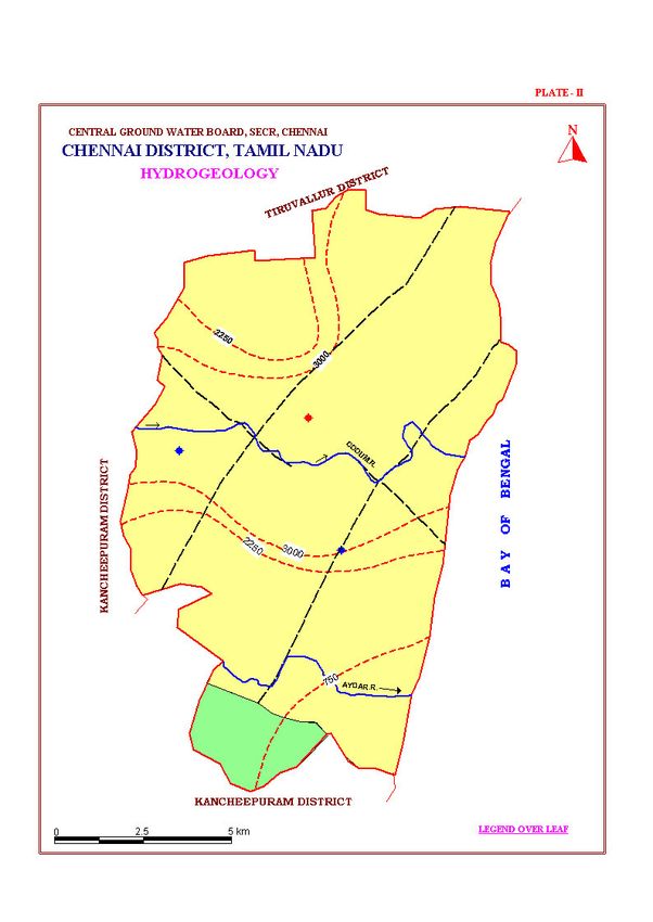
DISTRICT AT A GLANCE (CHENNAI DISTRICT)

S. No.                        ITEMS                                    STATISTICS
1.
         GENERAL INFORMATION
         i. Geographical area (Sq. km)                                                       174
         ii. Administrative Divisions (As on 31-3-2007)
              Number of Taluks                                                                 5
              Corporation                                                                      1
         iii. Population (As on 2001 Census)
              Total Population                                                         4343645
                          Male                                                         2219539
                          Female                                                       2124106
         iv. Average Annual Rainfall (mm)                                                 1200
2.       GEOMORPHOLOGY
         i. Major physiographic Units                        1. Fluvial land forms
                                                             2. Marine land forms
                                                             3. Erosional land forms
         ii. Major Drainages                                 .
3.       LAND USE (Sq. km) (2005-06)                         Adyar & Cooum
         i. Forest area                                                                        3
         ii. Net area sown                                                                     -
         iii. Cultivable area                                                                  -
4.       MAJOR SOIL TYPES                                   Beach sands, Clay & alluvial
                                                            soils
5.       NUMBER OF GROUND WATER MONITORING WELLS OF CGWB
          (As on 01.05.2008)
         i. Dug wells                                                                         11
         ii. Piezometers                                                                       3
6.       PREDOMINANT GEOLOGICAL                             Alluvium, sandstones
         FORMATIONS                                         (argillaceous), clay, shale, silt
                                                            stone, granites, gneisses and
                                                            charnockite
7.       HYDROGEOLOGY
         i. Major water bearing formations                  Sand, sandstone, weathered and
                                                            fractured granites, gneisses and
                                                            Charnockite
         ii. Pre monsoon depth to water level (May 2006)             2.21–7.64 m bgl
         iii. Post monsoon depth to water level (Jan. 2007)           0.45-5.32 m bgl
         iv. Long term water level trend in 10 years (1998-               Annual
              2007) (m/yr)                                        Rise               Fall
                                                            Min: 0.003        Min:0. 04
                                                            Max: 0.93         Max:0. 78

                                                                                         i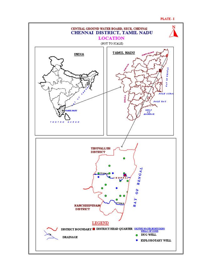
8.    GROUND WATER EXPLORATION BY CGWB (As on 31-03-2007)
      i. Number of Exploratory wells                                    5
      ii. Number of Observation wells                                   3
      iii. Number of Piezometers under Hydrology
           Project-I                                                    3
      iv. Depth range (m bgl)                                        39–225
      v. Discharge (lps)                                              1–25
      vi. Storativity (S)                                     2.9 x10⁻⁴ to 4.5x10⁻³
      vii. Transmissivity (m2/day)                                  6.00–872
9.    GROUND WATER QUALITY
      (As on MAY 2006)
      i. Presence of chemical constituents more than        TH as CaCO3, NO3 and Fe
          permissible limit
      ii. Type of water                                          NaCl, Ca-HCo3
10.   AWARENESS AND TRAINING ACTIVITY
      i. Mass Awareness Programs Organized
           Year                                                     1998-99
           Place                                                    Chennai
           No. of Participants                                         200
      ii. Water Management Training Organized
           Year                                              1998-99 & 12004 - 05
           Place                                             Besant Nagar, Chennai
           No. of Participants                                         28
11.   EFFORTS OF ARTIFICIAL RECHARGE &               Technical Guidance were provided
      RAINWATER HARVESTING                           as when sought
      i. Projects completed by CGWB                   i. 2 (Percolation Ponds) in CLRI
          Number of structures                       Rs. 7.51 lakhs
          Amount spent                               ii. Rooftop rainwater harvesting in
                                                     SG & SWRDC, Taramani
                                                     Rs. 7.6 lakhs
      ii. Projects under technical guidance of CGWB     Nil
          Number of structures
12.   MAJOR GROUND WATER PROBLEMS AND                 1. Insitu salinity in Mandhaveli,
      ISSUES                                             Anna nagar, Indira nagar,
                                                         Velacheri, and Taramani areas.
                                                      2. Higher concentration of Iron in
                                                         ground water in K.K. Nagar,
                                                         Anna Nagar, Valasaravakkam,
                                                         R. A. Puram areas.
                                                      3. Contamination of ground water
                                                         all along the Buckingham Canal
                                                         within the city.
                                                      4. Over exploitation of ground
                                                         water has resulted in change in
                                                         quality of ground water in Besant
                                                         Nagar area- Sea water ingress.

                                                                                   ii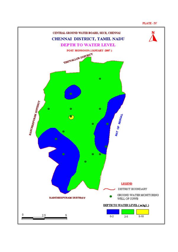
1.0.   INTRODUCTION

1.1    Administrative Details

Chennai district (Plate-I) is having administrative divisions of 5 taluks and 1 corporation.
Chennai Corporation is divided into 155 administrative divisions (Table-1).

                           Table-1. Administrative Divisions

            S. No.               Taluk                    No. of Divisions

           1          Purasavalkam, Perambur         31 (32 – 63)

           2          Fort-Tondiarpet                31 (1 – 31)

           3          Mambalam-Guindy                11 (130 – 141)

           4          Mylapore-Triplicane            30 (79 – 96) & (142-155)

           5          Egmore-Nungambakkam            46 (64 –78) & (97-129)

                                         (Source: Assistant Director of Statistics, Chennai)

1.2    Basin and sub-basin

Chennai district falls in part of Korattalaiyar-Arniyar River basin.

1.3    Drainage

Adyar River originates at the confluence (Thiruneermalai) of two streams that drains the
upstream area of Chembarambakkam tank. It is a small river of 42 km length and a
catchment of 800 Sq. km. The river carries flow all through 365 days of a year with an
average discharge of 89.43 MCM/Year at Kattipara cause way. It drains the southern part
of the district and remains flooded during monsoon. During the high tides, the backwaters
from the Bay of Bengal enter inland up to 3 – 4 km.

Cooum is the other main river flowing through the central part of the district and carries
only drainage water, which is highly polluted. It originates from the surplus waters from
the Cooum tank in Tiruvallore taluk and the tanks, which are in enroute, discharge their
surplus water into the river during flood season. The flow of Cooum River at Korattur is
40.2 MCM/year for an average duration of 31 days in a year.

Otteri Nulla is another small stream flowing in the northern part of the city. Buckingham
canal is the man made one for navigation purposes earlier, but now it act as sewerage
carrier in the city.

1.4    Studies/Activities carried out by CGWB
Central Ground Water Board had taken up exploration in Gondwana sediments of

                                                                                          1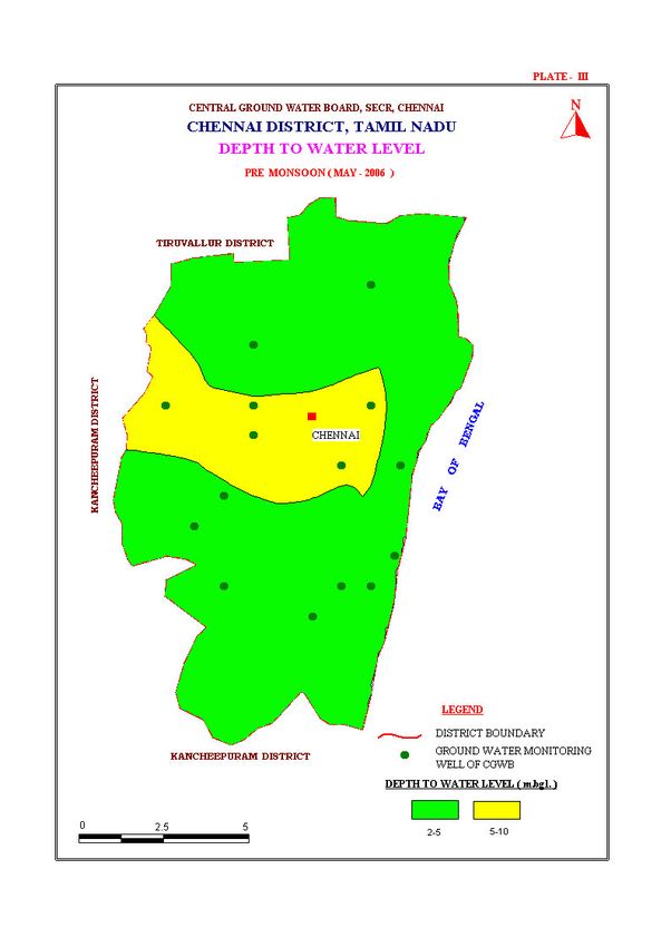
Chennai and its environs during their annual work programme of 1992-93. Central
Ground Water Board has taken up number of consultancy works during the year 1989-92
and collected extensive data on sub-surface lithology and quality of water as well as
characteristics in different parts of Chennai city.

The Central Ground Water Board has taken up ground water regime monitoring in
Chennai district. There are 14 ground water monitoring wells and are monitored since
1986. Water samples are collected during May to study the changes in water quality with
time and space.

2.0.    RAINFALLS AND CLIMATE
The northeast monsoon during the month of October, November and December chiefly
contributes the rainfall for the district. Most of the precipitation occurs in the form of one
or two cyclones caused due to depressions in Bay of Bengal. The southwest monsoon
rainfall is highly erratic and summer rains are negligible. The average annual rainfall of
the district is 1200 mm (1978-2008).

Chennai district enjoys a tropical climate with mean annual temperature of 24.3 to 32.9°
C. The temperature is usually in the range of 13.9 to 45° C.

The humidity is usually in the range of 65 to 84% and sea breeze in the evening hours is a
blessing to combat the high temperature and humidity during summer months.

3.0    GEOMORPHOLOGY AND SOIL TYPES

3.1    Geomorphology
Chennai district forms part of coastal plains of Tamil Nadu. Major part of the district is
having flat topography with very gentle slope towards east. The altitudes of land surface
vary from 10 m above MSL in the west to sea level in the east. Fluvial, marine and
erosional landforms are noticed in the district. Marine transgression and regressions and
neo-tectonic activity during the recent past have influenced the morphology and resulted
in various present landforms.

Meandering streams with small sand bars are present along the course of Adyar River.
The pediment and buried pediment in Guindy area in and around the reserved forest, is
the only area where the ecological system is less disturbed, while the other areas are
completely disturbed by built up area with large-scale human interference and pollution.

Marina beach is the most natural beach in the world with a width varying from 150 to
600 m and a length of 5.6 km, also encroached by human activity. Theosophical society,
located on the banks of Adayar river mouth is the only area with well-preserved natural
coastal morphology, sand dunes, beach ridges, flora etc.

                                                                                            2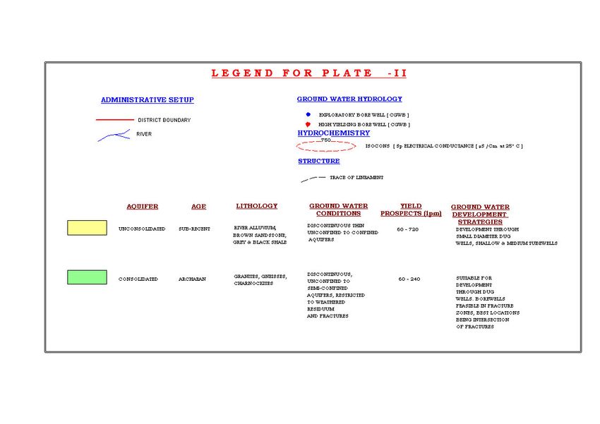
4.0    GROUND WATER SCENARIO

4.1    Hydrogeology
Chennai district is underlain by various geological formations from ancient Archaean to
the Recent Alluvium. The geological formations of the district can be grouped into three
units, namely i) the Archaean crystalline rocks ii) consolidated Gondwana and Tertiary
sediments and iii) the Recent Alluvium. The Archaean crystalline rocks of the district
comprise chiefly of charnockites, gneisses and the associated basic and ultra basic
intrusives. A map showing the hydrogeology of the district is given as Plate–II.

The crystalline rocks are weathered and jointed/fractured. The degree and depth of
weathering varies from place to place and the thickness of weathered mantle varies from
less than a metre to about 12 m in this district. The successful bore wells drilled tapping
the deeper fractured aquifers in Saidapet, Adyar, Kasturba nagar, Gandhi nagar and
Ashok nagar revealed the existence of fracturing down to depth of 60 m below ground
level.

The Gondwana shale is black to dark grey in colour and is jointed/fractured. They are
encountered in a number of boreholes and their thickness varies from 24 m in Kilpauk
area through 20 m in Ashok Nagar area to more than 130 m in Koyambedu area.

The occurrence of Tertiaries in Chennai district is not well demarcated. However, the
sandstones encountered in some of the boreholes below alluvium in Binny Road, Poes
Garden, Anna Nagar and Rayapuram areas, which belong to Tertiary group. The granular
zones below the Kankar layer in the depth range of 20-28 m bgl in Poes Garden probably
represent Tertiary sandstones and tube wells tapping these granular zones yield 2 to 3 lps.

Ground water in Chennai district occurs in all the geological formations viz., the
Archaean crystallines, Gondwanas, Tertiaries and alluvium and is developed by means of
ring wells, dug wells, filter point wells, bore wells and tube wells. The yield and depth
range of aquifers is given in Table-2.

                         Table-2.Yield and depth range of aquifers

              Formation           Type of well     Depth range         Yield
                                                     (m bgl)            (lps)
           Alluvium              Tube well                10-30             1-12
                                 Dug well                  6-11      0.058-1.16
           Sandstone             Tube well                20-28               2-3
           Gondwana              Tube well                20-60               1-3
           Crystalline           Bore well                10-15          Up to 4

The alluvium covers the major part of the district. The alluvium consists of sand, silts and
clays. The thickness of alluvium varies from place to place and a maximum of 28 m is
encountered in north Chennai near Perambur. Kilpauk water works area has 24 m thick
alluvium.

                                                                                          3
The yield of the wells at Kilpauk and Tirumangalam tapping the productive granular zones met within the alluvium is 25 lps and 6 lps for a drawdown of 7.21 and 0.22 m with a specific capacity of 206.35 and 40 lpm/m of drawdown respectively. The yield of four bore wells tapping the productive granular zones met within the Gondwana sediments were found to range from less than 1 to 4 lps for drawdowns varying between 8 to 9 m. The specific capacity ranged from 8 to 32 lpm/m of drawdown. In Velacherry area there is a sheet of black clay over crystalline rocks. The open wells located in Velacherry area are giving moderate yield and the yield of wells varies from 2 to 10 m3/day depending on the diameter, topography and thickness of weathering. Many wells are dry in summer months due to limited thickness of productive zones or over development. There are a few fractures developed in the crystalline rocks and select bore wells hence encountered such fractures down to 90 m. The yields of these bore wells are as high as 4 lps at select sites. There are no indications of any prominent lineaments. There are number of bore wells in the city piercing the top 10 to 15 m thick alluvial cover and penetrate the crystalline rocks. The failure of many bore wells in Velacherry area may be due to absence of potential fracture down to 60 m bgl. During May 2006, the depth to water levels in observation wells tapping shallow aquifer ranged from 2.21 to 7.64 m bgl. Shallow ground water levels i.e., less than 5 m bgl were prominently observed in observation well at Alwarpet, Besant Nagar, K.K. Nagar, Tondiarpet and Velacherry. Water levels >5 m bgl and
4.2    Ground Water Quality

Ground water in phreatic aquifers in Chennai city in general is colourless, odourless and
slightly alkaline in nature. The specific electrical conductance of ground water in phreatic
zone (in Micro Siemens at 25° C) during May 2006 was in the range of 475 to 9350 in
the district. It is observed that in most of the samples EC falls above 2250 Micro Siemens
at 25° C. Conductance below 750 µS/cm have been observed in only one sample in
Besant Nagar.

It is observed that the ground water is suitable for drinking and domestic uses in respect
of all the constituents expect total hardness and Nitrate. Total Hardness as CaCO3 is
observed to be in the excess of permissible limits in about 55 percent of samples analysed
whereas Nitrate is found in excess of 45 mg/l in about 10 percent samples. The incidence
of high total hardness is attributed to the composition of litho units constituting the
aquifers in the district, whereas the Nitrate pollution is most likely due to improper
disposal of waste.

4.2.1. Status of ground water development

Ground water development is related to the water supply position. The relation between
water supply and ground water development makes it difficult to quantify or generalize
the ground water extraction. The ground water is developed through dug wells in alluvial
areas, tube wells and bore well in area characterised by sedimentary and crystalline rocks
respectively. In general, the depths of dug wells varied from 10 to 15 m bgl while the
tube well and bore wells are in the depth range of 60-100 m bgl. The tube wells / bore
wells in general can sustain a pumping of 6 –10 hrs in a days while dug wells can sustain
for 2-4 hrs a day.

5.0    GROUNDWATER MANAGEMENT STRATEGY

The dug wells, filter point wells, tube wells and bore wells are the most common
abstraction structures in the district. The dug wells are constructed in the alluvium as well
as in hard rock areas in the city. The depth of the wells generally ranges between 10 and
15 m bgl and as shallow as 4 m bgl in Marina beach and the masonry structures are
common. Some of the wells in coastal tract are tapping beach sands and are brick lined
with cement plastering on the top 6 m. The deepening of structures with small diameter
ring well inside the open well is commonly practiced.

5.1.   Suitable well design

The following well designs are recommended for the Chennai city area (i) infiltration
well with horizontal and extension bores (ii) shallow tube well (Hand auger) (iii)
shallow/medium tube well (Rotary rig) and (iv) deep bore well. Infiltration wells of 4.5 m
diameter and of 6 to 7 m bgl depth in beach aquifers of Besant Nagar are likely to give
416 to 4166.6 lph. Shallow tube wells of 100 /125 mm diameter and of 10 to 20 m bgl

                                                                                           5
depth are likely to yield 1000 lph and shallow/medium tube wells with proper gravel
packing will give 1000-30,000 lph. The deep bore wells of 45-60 m bgl depth are likely
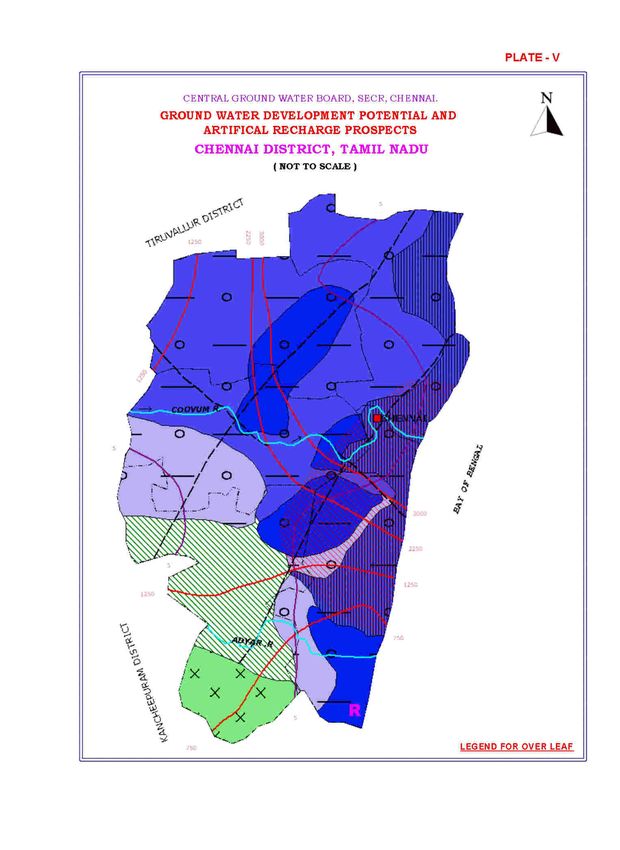
to give 1000 to 45,000 lph. The map showing the development prospects for the district is
shown in Plate-VI.
5.2. Water Conservation and Artificial Recharge
CGWB has rendered technical assistance to local residents and a few Central
Government Organizations in implementing Rainwater harvesting. In addition to this it
has also given financial assistance for construction of percolation ponds (2 Nos.) with
recharge shafts and dug well recharge in CLRI under Central Sector Scheme An amount
of Rs.7.51 lakhs have been funded.
Rooftop rainwater harvesting in State Ground & Surface Water Resources Data Center,
Taramani has been implemented for an amount of Rs. 7.6 lakhs funded by Ministry of
Water Resources, Government of India under Fresh Water Year.
The Government of Tamil Nadu, has made it mandatory that all buildings in Tamil Nadu
should have provision for roof top rainwater harvesting. Details of rainwater harvesting
carried out in Chennai city are given Table-3.
Table-3. Details of rainwater harvesting carried out in Chennai city
Building covered with
% of
Sl. No. Total No. of buildings Rainwater harvesting as
coverage
on 26.06.03
1 Residential 291464 276401 94.83
2 Commercial 26064 21846 83.83
3 Institutional 1454 1179 81.08
4 Government 2999 2680 89.36
Total 321978 300519 93.34
(Source: Chennai Metropolitan Water Supply and Sewerage Board)
6.0. GROUNDWATER RELATED ISSUES & PROBLEMS
1. Insitu salinity in Mandhaveli, Annanagar, Indira nagar, Velacheri, and Taramani
areas.
2. Higher concentration of Iron in ground water in K.K. Nagar, Anna Nagar,
Valasaravakkam, R. A. Puram areas.
3. Contamination of ground water all along the Buckingham Canal within the city.
4. Over exploitation of ground water has resulted in change in quality of ground
water in Besant Nagar area.
67.0 Awareness & Training Activity
7.1 Mass Awareness Campaign (MAP) & Water Management Training
Programme (WMTP) by CGWB
One mass awareness program was organized in Chennai during the year 1988-99 and
about 200 persons from different sectors participated.
One water management Training was conducted in Chennai during the year 1988-99 and
about 28 persons from different institutions including Universities attended the training.
Second training on water management was conducted during 2005 at Chennai about 21
personnel from various central and state agencies attended the training
7.2 Participation in Exhibition, Mela, Fair Etc.
Participated in the inter school science exhibition organized by Tamil Nadu science and
Technology Centre, Chennai from 27.11.03-30.11.06.
7.3. Presentation & Lectures delivered in Public Forum/Radio/TV/Institution of
Repute/Grass roots association/NGO/Academic Institutions etc
8.0 AREA NOTIFIED BY CGWA/SGWA
Government of Tamil Nadu has banned extraction of ground water for commercial
purposes in Chennai district.
9.0. RECOMMENDATIONS
To meet the increased demand in future, recycling of industrial wastewater has to be
planned and implemented. A centralised system of collecting effluents of treatment plants
for recycling of water can be prepared separately for Adyar River, Cooum river,
Buckingham canal system. Lining of vulnerable sections will reduce ground water
pollution by influent seepage of bad water as well as polluted effluents.
Two pipe lines systems Viz. one line for drinking water supply and the other for recycled
water for other uses can be initiated on experimental basis at select places and can be
implemented on the success of the initiative.
The local development of ground water should be on scientific lines. There are already
indications of movement of interface in the coastal belt in Besant Nagar, Tiruvanmiyur
etc. This has to be closely monitored by periodical hydrochemical sampling, as otherwise
the damage once sets in can never be reversed.
7The conventional drilling techniques should be improved and the failure of wells due to
wrong designing has to be avoided. The failure of open wells due to choking of weep
holes can be avoided by cleaning the well with Sodium Polyphosphate (Sodium Hexa
Meta Phosphate) and adding horizontal filter points. The heavy drawdown created by
high capacity pump should be avoided in the coastal area and safe yield of any
abstraction structures and suitable pump has to be decided on scientific pumping test of
wells. Improved design of ring wells with slotted copper mesh windows can be used.
Studies on pollution to ground water are to be taken up urgently and suitable follow up
measures are to be adopted to protect the environment and prevent problems in future.
89
10
11
12
13
14
LEGEND FOR PLATE - V

                                        DISTRICT – CHENNAI

                                                                      Depth of Well        Discharge        Suitable Artificial
                           Wells Feasible             Rigs Suitable
                                                                         (mbgl)             (LPM)          Recharge Structures
                          Tube Well               Rotary (Calyx)      20 – 30            10 – 100          Roof Top rainwater
                          Tube Cum Bore Well      Hand Bore / DTH     45 - 60            10 - 60           Harvesting
   Soft Rock Aquifer
                                                                                                           Recharge Tube Well

                          Tube Well               Rotary (Calyx)      20 – 40            50 – 100          Roof Top rainwater
                                                  Direct Rotary       100 -150           100 - 200         Harvesting
    Soft Rock Aquifer                                                                                      Recharge Tube Well

                          Dug Well                Manual              10 – 15            100 – 200         Roof Top rainwater
                          Tube Well               Rotary (Calyx)      10 – 45            60 - 200          Harvesting
                                                                                                           Recharge Tube Well
   Soft Rock Aquifer

                          Dug Well                Manual              8 – 12             50 – 100          Recharge Well
                          Bore Well               Down The Hole       45 - 60            20 – 50           Roof Top rainwater
   Hard Rock Aquifer
                                                  (DTH)                                                    Collection & Storage in
                                                                                                           Sump

                          Bore Well               DTH                 40 - 60            10 - 100          Trenches/Recharge Wells/
                                                                                                           Roof Water rainwater
                                                                                                           Harvesting
  Thin Sediments/Hard
         Rock
                          District Boundary

                          District Headquarter                        1250               EC in micro siemens / cm at 25° C

    5                     Water Level-Pre-Monsoon (Decadal Mean                          Lineament
                          1993-2002) mbgl

                         River with flow direction                                      Nitrate greater than maximum permissible
                                                                                         limit (45 mg/l)

                          Fluoride greater than maximum permissible
                          limit (1.5 mg/l)

                                          OTHER INFORMATION

Geographical Area                                                     174 Sq. Km.
Number of Taluks                                                      5

Major Drainage                                                        Adyar & Cooum
Population (2001)                                                     4343645

Average Annual Rainfall                                               1200 mm

Annual Range of Temperature                                           18 – 41°C
                                                                      Soft rocks: Alluvium, Tertiary/Gondwana Sediments
Regional Geology
                                                                      Hard rocks: Granites, gneisses,charnockites.

                                                                                                                    15
Published by: Regional Director, CGWB, SECR, E-1, Rajaji Bhavan, Besant Nagar, Chennai-90
+914424912941/24914494 /Fax : 91 4424914334 Web: www.cgwb.gov.in
rdsecr-cgwb@nic.inYou can also read