CHANTRY, STOKE PARK AND MAIDENHALL CHARACTER AREA - IPSWICH URBAN CHARACTERISATION STUDY
←
→
Page content transcription
If your browser does not render page correctly, please read the page content below
CHANTRY,
STOKE PARK AND
MAIDENHALL
CHARACTER AREA
IPSWICH URBAN CHARACTERISATION STUDY
CONTENTS
Introduction                       1

History                            2

Transport and Access               5

Open Space                         6

Biodiversity and Archaeology       7

Landform and Views                 8

Urban Analysis                     9

Character Sub Area Description –
Belstead Road                      10

Character Sub Area Description –
Stoke Park & Maidenhall            12

Character Sub Area Description –
Chantry                            14

Summary                            17
CHANTRY, STOKE PARK AND MAIDENHALL CHARACTER AREA
INTRODUCTION 3
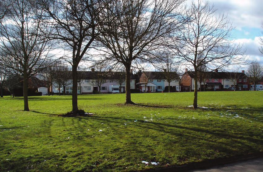
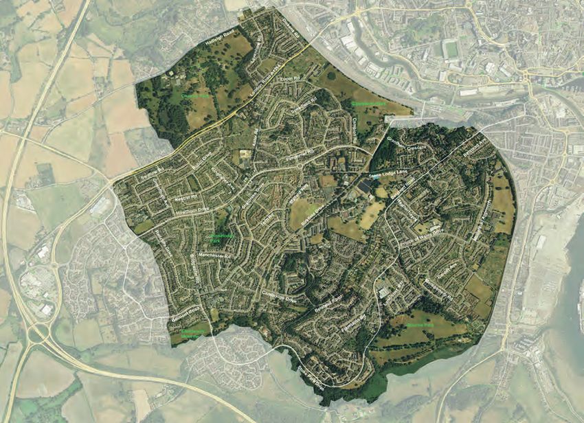
The character area comprises one of Ipswich’s most popular residential
suburbs, occupying the sweep of upland between the Orwell and the
Belstead Brook. It divides into three character sub areas:
• Chantry
• Stoke Park and Maidenhall
• Belstead Road
In the 20th century, the area of former park and farmland was developed
into low density estates, designed around the garden settings of Stoke
Park and The Chantry. Many mature parkland trees have been protected
and the slopes offer extensive views over Ipswich, the estuary and
Suffolk countryside.
The general character of the area reflects the design aspirations of public
housebuilding in the middle decades of the 20th century; large, solidly
built semi detached and terraced housing with generous gardens,
arranged around distributor roads and culs de sac with broad grass
verges.
The topography, railway line and river tend to isolate the suburb from its
urban surroundings, but this is compensated for by efficient road
connections, a good bus service and a location which enables the
railway station and town centre to be reached on bike and foot.
Chantry Green
Imagery copyright Getmapping PLC
The Chantry, Stoke Park and Maidenhall urban characterisation area and sub-areas.
The parkland trees and open spaces are the most characteristic historic
features, along with the Grade II listed Chantry and estate buildings.
The site of the mansion at Stoke Park has been redeveloped, but many of the
fine Victorian and early 20th century villas along nearby Belstead Road survive
along with their mature garden settings. Further areas of open space and
mature tree planting have been retained within the grounds of educational
institutions.
Downside Close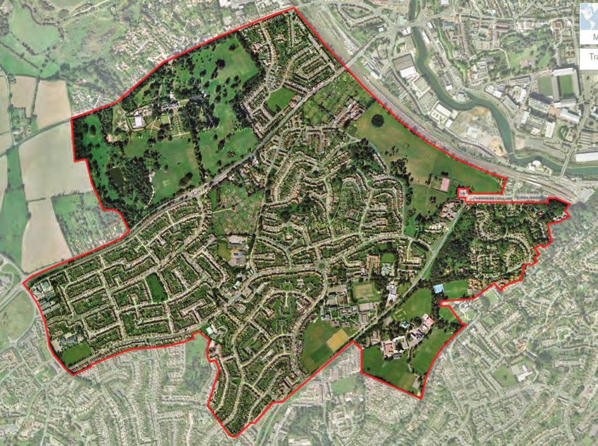
CHANTRY, STOKE PARK AND MAIDENHALL CHARACTER AREA
HISTORY 4
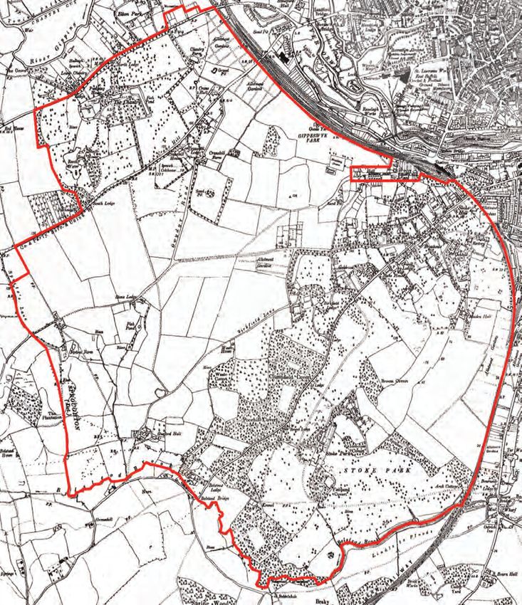
History The relatively undisturbed landscape has
This area remained the most undeveloped preserved some of the earliest evidence of
part of Ipswich’s rural hinterland until well activity in the Ipswich area. In the 1960s,
into the 20th century. The ancient settlement during excavation works for housing, a
of Stoke only started to expand across the hoard of solid gold torcs - Iron Age necklace
lower slopes of Stoke Hill during the ornaments, dating from around 75BC – were
Victorian period, and the rapid growth of discovered near the source of a spring
residential neighbourhoods seen elsewhere above Belstead Brook.
in Ipswich was checked by the boundaries
of the large estates at Stoke Park and The
Chantry.
Early photographs give a good idea of the
area’s character. The image below is of the
Belstead Brook around a century ago, in a
completely rural setting. Analysis of the tithe
map for St Mary at Stoke parish shows that
in 1840 approximately 60% of the land was
used for arable farming, another 25% for
pasture and the remainder for housing,
gardens and parkland. Iron Age Torcs, found near Ellenbrook Drive.
The Chantry area in 1938 (Ordnance Survey map)
Belstead Brook c.1900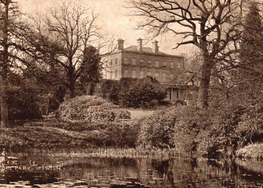
CHANTRY, STOKE PARK AND MAIDENHALL CHARACTER AREA
 HISTORY                                                                                                                                                                                                                                                          5

 The grounds of Broadwater House during the First                                                                                                                                              In the 20th century, bequests transferred these
 World War when the house was being used as a
                                                                                                                                                                                               estates into public ownership. Ambitious house
 convalescent home.
                                                                                                                                                                                               building programmes, both before and after the
                                                                                                                                                                                               second world war, took advantage of the
                                                                                                                                                                                               topography and mature parklands, creating
                                                                                                                                                                                               some of Ipswich’s most attractive residential
                                                                                                                                                                                               settings.

 Following the Reformation the former abbey
 lands were divided into private estates. The
 owners continued to farm the land, for example
 Andrew Sulyard who built Gyppeswyk Hall in the
 early 16th century (originally called New Place).
 Edmund Daundy, an Ipswich merchant,
 purchased the land which would become, in the
                                                                                                                                                                                               Grading of farmland in preparation for the construction of phase
 18th century, The Chantry.                                                                                                                                                                    1 of the Chantry housing estate (early 1950s)

 These projects were able to take advantage of       Stoke Park. The mansion in the photograph was built in the 1830s by Lord Belstead on the site of an earlier house and demolished in the
 the availability of land, the open views and the    mid 1920s.                                                                                                                                Construction of public housing began in the
 springs – ideal for parkland with ornamental                                                                                                                                                  1930s with the estates off London and Hadleigh
 water features.                                                                                                                                                                               roads. After the war, larger estates were laid out
                                                                                                                                                                                               in the Chantry and Maidenhall areas.
 Peter Burrell, the 4th Baron Gwydyr, inherited
 Stoke Park in 1848. He invested large sums in                                                                                                                                                 The publicly funded and designed estates were
 both the house and the remodelling of the                                                                                                                                                     laid out following modern standards of public
 extensive parklands. Although the house has                                                                                                                                                   space provision, local services and transport
 been lost, much of the mature tree planting on                                                                                                                                                connnections. Generous open spaces were
 the south east side of the character area has                                                                                                                                                 created, reflecting pre-war ideas about garden
 been preserved.                                                                                                                                                                               city design. Roads were run around the
                                                                                                                                                                                               contours of the land and as many parkland trees
 On the extensive areas of land between the                                                                                                                                                    preserved as possible. Housing areas were
 estates, mixed agricultural use continued                                                                                                                                                     served by purpose designed district and local
 throughout the 18th and 19th century. A number                                                                                                                                                centres.
 of windmills were constructed, creating
 landmarks on the Ipswich skyline which can be                                                                                                                                                 Residential development has continued to the
 seen in prints and paintings from the period.                                                                                                                                                 present day, in recent decades mostly private
                                                     Windmills were landmarks on the Ipswich skyline; 17 were visible in the 1830s of which 6 were in the Stoke area. The engraving, dated
                                                     1843, shows two of the mills on Stoke Hill. The appearance of residential development wasn’t welcomed by everyone. On Stoke Hill the      sector construction.
                                                     miller complained that nearby housing was robbing the wind from his sails!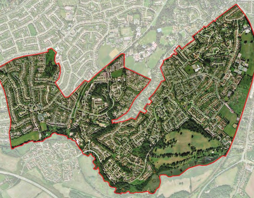
CHANTRY, STOKE PARK AND MAIDENHALL CHARACTER AREA
 HISTORY                                                                                  6

 Robin Drive, Chantry (late 1950s)                  Chantry Green 2015

 Hawthorn Drive District Centre (late 1950s)        Ellen Brook Green Local Centre 2015
CHANTRY, STOKE PARK AND MAIDENHALL CHARACTER AREA
     TRANSPORT AND ACCESS                                                                                                                                 7

                                                                                       Much of the built environment and
                                                                                       infrastructure has been masterplanned from
                                                                                       scratch, reflecting the priorities of the postwar
                                                                                       decades (a demand for family housing and the
                                                                                       social and retail facilities required to service
                                                                                       that need). The low density layout is served by
                                                                                       a neighbourhood road network which is well
                                                                                       connected to the surrounding primary routes,
                                                                                       both for cars and bus services.
                                                                                       The road design, which encourages higher
                                                                                       vehicle speeds, is less attractive for
                                                                                       pedestrians and cyclists though a number of
                                                                                       parks and green spaces provide attractive
                                                                                       routes for both. Compare, for instance,
                                                                                       Birkfield Drive (development set back from the
                                                                                       roadside, few junctions, higher speeds) with
                                                                                       Belstead Road (shorter sightlines,
                                                                                       development and mature trees closer to the
                                                                                       road edge, lower speeds).

                                                                                       Kestrel Road - typical residential street with generous verges,
                                                                                       though most streets lack the tree planting.

                                                                                       Birkfield Drive. The road is set within a broad landscaped strip
                                                                                       originally intended for a dual carriageway - it even has an
                                                                                       underpass.

© Crown Copyright and database right 2015. Ordnance Survey Licence number 100021566.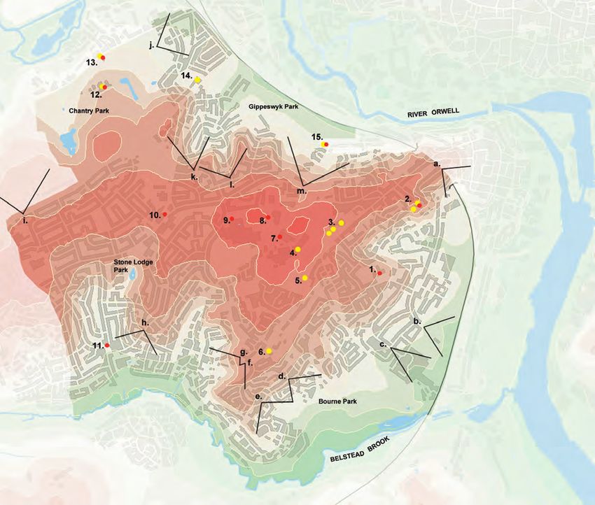
CHANTRY, STOKE PARK AND MAIDENHALL CHARACTER AREA
 OPEN SPACE                                                                                                                                                                                    8

                                                                                                Biodiversity                                  define the well wooded and rich varied
                                                                                                The south west area of Ipswich benefits       landscape of this area. Areas of recent
                                                                                                from good open space provision                meadow creation and tree planting along
                                                                                                including large parks on three of its         Birkfield Drive have greatly enhanced the
                                                                                                boundaries: Chantry Park in the               biodiversity of the corridor.
                                                                                                north-west, Gippeswyk Park in the
                                                                                                north-east and Bourne Park in the             Gardens play an important role in
                                                                                                south-east. The southern boundary is          providing wildlife habitat and links into the
                                                                                                marked by Belstead Brook Park.                ecological network. Any future reduction
                                                                                                                                              in the size or number of gardens could
                                                                                                County Wildlife Sites within the area are:    result in a net loss of biodiversity and
                                                                                                • Ashground Covert and Bobbits Lane           reduced effectiveness of the ecological
                                                                                                  Meadows (Stoke Park), with diverse          network.
                                                                                                  habitats consisting of herb rich and
                                                                                                  rough grass meadows, fen, semi-natural      Opportunities for enhancing the
                                                                                                  woodland, seasonal wet woodland,            biodiversity value of homes and gardens
                                                                                                  scrub, hedgerow, reedbed, stream and        should be promoted, e.g. swift and bat
                                                                                                  ponds.                                      features, native tree and shrub planting,
                                                                                                • Bourne Park Reedbed (Stoke Park),           ponds and other water features, fencing
                                                                                                  which contains habitat including            with gaps for hedgehogs and so on.
                                                                                                  reedbed with open areas of shallow          Linear features that support the corridor
                                                                                                  water and seasonal mud, and tall rough      functions will be most important,
                                                                                                  grassland.                                  including hedgerows and ditches.
                                                                                                • Stoke Park Wood (Stoke Park), which is
                                                                                                  mixed woodland, scrub and historic
                                                                                                  grassland.
                                                                                                • Chantry Park (in Chantry), the
                                                                                                  designated part of which contains wet
                                                                                                  and dry broadleaf woodland, scrub,
                                                                                                  species-rich rough grassland, and a
                                                                                                  lake.

                                                                                                Just to the south of the character area,
                                                                                                the rest of Belstead Brook Park includes
                                                                                                significant wildlife sites including Spring   Clump Field
                                                                                                Wood, Millennium Wood, Bobbits Lane
                                                                                                Meadows and Kiln Meadow. This area
                                                                                                and the Belstead Brook itself are
                                                                                                renowned for wildlife and species include:
                                                                                                otter, brown trout, water vole, dormouse,
                                                                                                badger, slow worm, common lizard, grass
                                                                                                snake, and common toad.

                                                                                                Belstead Road and Birkfield Drive tree
                                                                                                belts/verges are amongst the most
                                                                                                significant corridors for wildlife and help   Stone Lodge Lane West water tower and resovoir
                     Contains Ordnance Survey data © Crown copyright and database right 2015.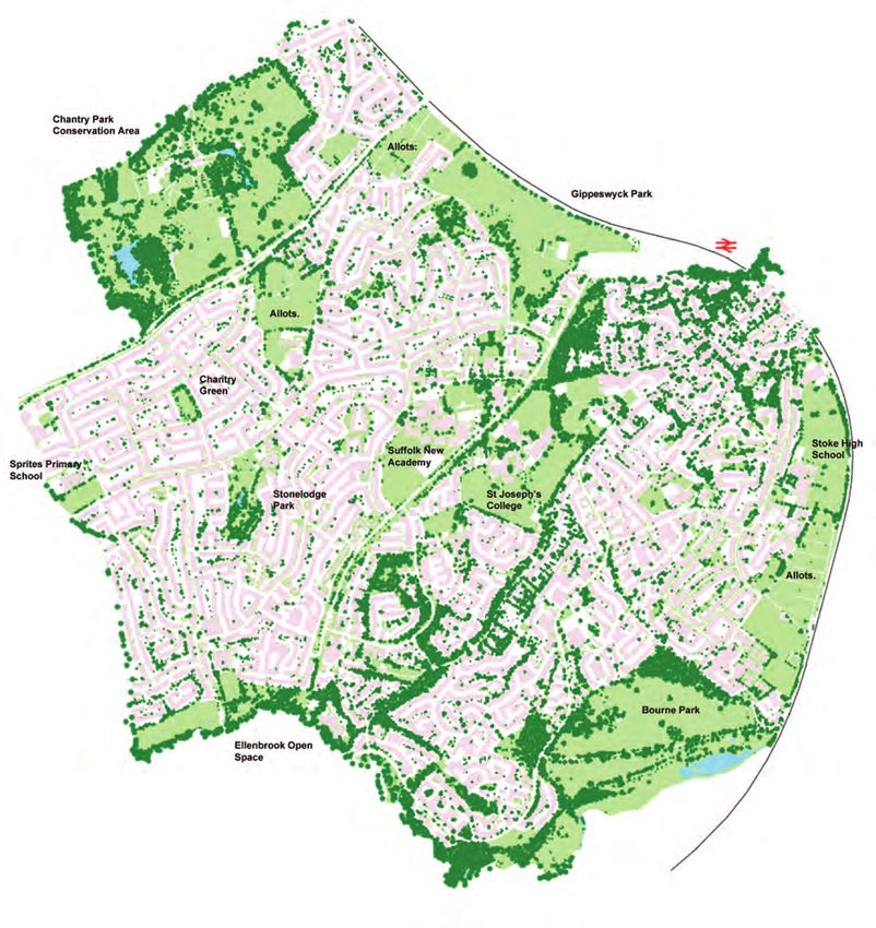
CHANTRY, STOKE PARK AND MAIDENHALL CHARACTER AREA
LANDFORM AND VIEWS 9
Views Landmark Buildings
Contains Ordnance Survey data © Crown copyright and database right 2015.
a Luther Road - view of Orwell 1 Halifax Primary School, Prince
estuary of Wales Drive
b Halifax Road - view of 2 Oakhill & Rockery, Oak Hill
estuary and Orwell Bridge Lane (Listed Grade II)
c Montgomery Road - view of 3 Goldrood House, Stables, Wall
estuary and Orwell Bridge and Gatepiers, Belstead Road
d Fountains Road - view of (Listed Grade II)
wooded farmland south of 4 St Josephs College, Belstead
Belstead Brook Road (Listed Grade II)
e Fountains Road - view of 5 St Josephs College Lodge,
wooded farmland south of Belstead Road (Listed Grade
Belstead Brook II)
f Girton Way - view of wooded 6 Round Lodge, Belstead Road
farmland south of Belstead (Listed Grade II)
Brook 7 St Josephs College, Birkfield
g Girton Way - view of wooded Drive
farmland south of Belstead 8 Watertower, Stone Lodge West
Brook 9 Suffolk New Academy, Mallard
h Sheldrake Drive - view of Way
wooded farmland south of 10 St Francis C of E Church & St
Belstead Brook Marys RC Church, Hawthorn
i Scrivener Drive - view of Drive
open countryside near 11 Belstead Arms Public House,
Sproughton Bridgewater Road
j Hadleigh Road - townscape 12 The Chantry (Listed Grade II)
view of Ipswich 13 North Lodge & Entrance Gate
k Lavenham Road - Piers, The Chantry, Hadleigh
townscape view of Ipswich Road (Grade II Listed)
I Shamrock Avenue/ 14 Crane Hall, London Road
Cornflower Close - (Grade II Listed)
townscape view of west 15 Gippeswyk Hall (Grade II
Ipswich listed)
m Pimpernel Road/Lavender
Hill - townscape view of
west Ipswich
Bridgewater Road
Landform and views
The elevated position creates good viewlines across Ipswich, the estuary and surrounding countryside, framed by mature tree planting.
Modern housing development has helped protect some of the best views. The creation of new viewlines as well as the protection of
existing views should be a development priority.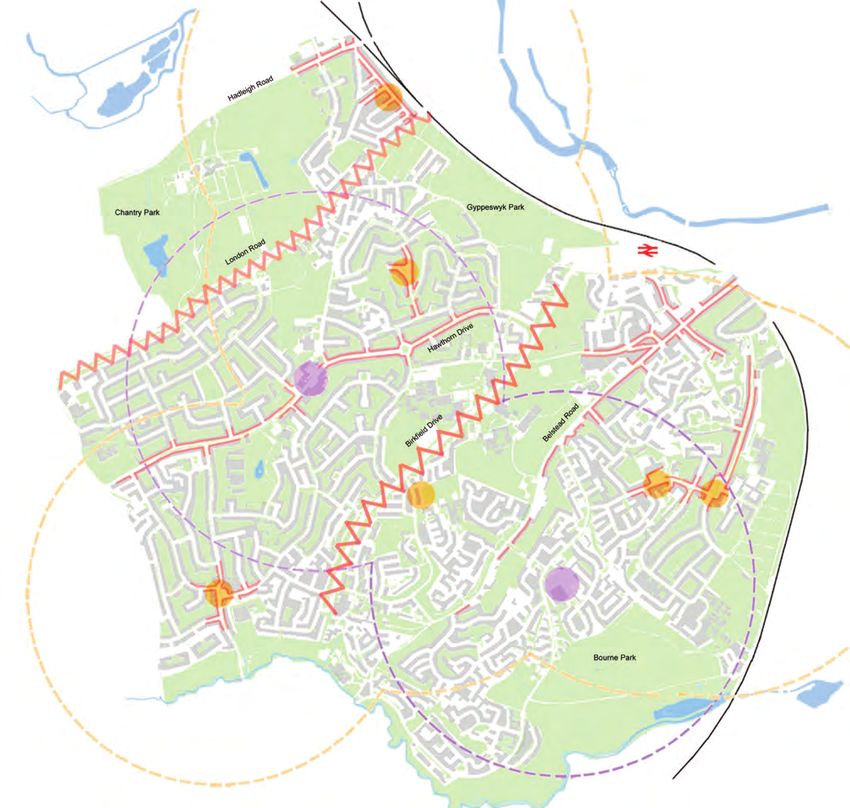
CHANTRY, STOKE PARK AND MAIDENHALL CHARACTER AREA
 URBAN ANALYSIS                                                                                                                                         10

                                                                            Birkfield Drive.
                                                                            The traffic corridor creates a speeding hazard and uses up valuable space

 Contains Ordnance Survey data © Crown copyright and database right 2015.
CHANTRY, STOKE PARK AND MAIDENHALL CHARACTER AREA
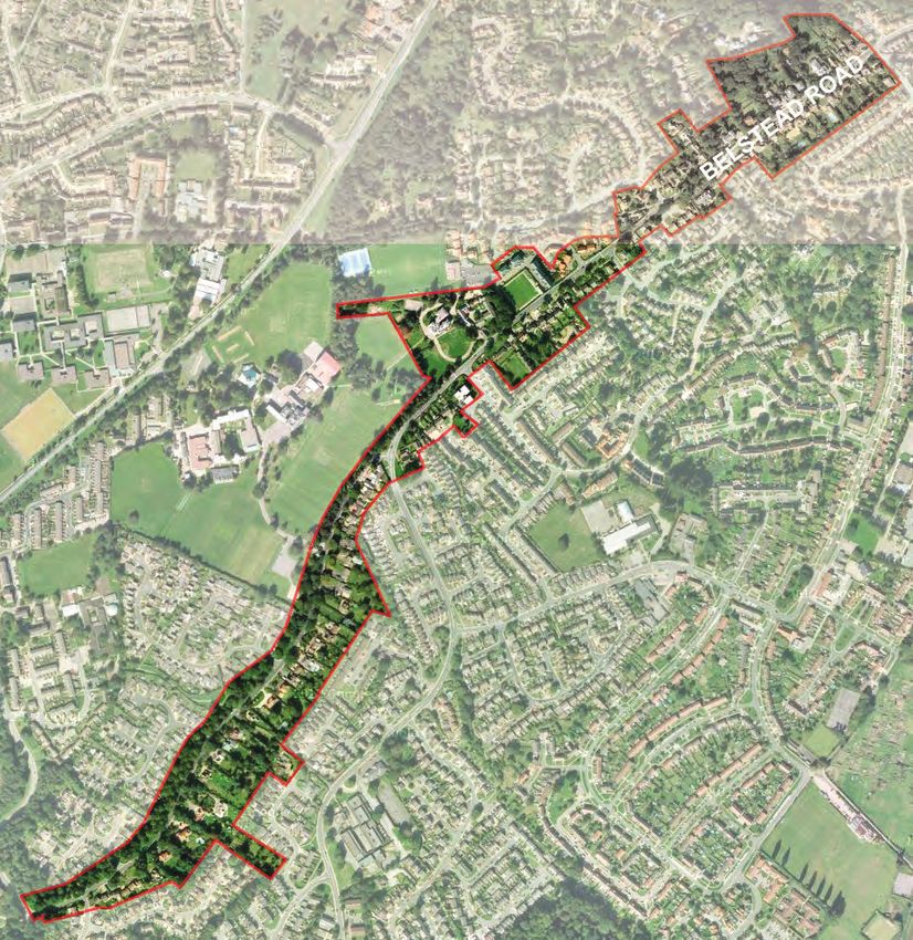
CHARACTER SUB AREA - BELSTEAD ROAD 11
Belstead Road is an important link between Stoke to the The character sub-area is linear and
north and the parkland landscape of Stoke Park to the focussed on the Belstead Road
south. Large 19th and early 20th century properties and frontage. It extends between the
mature trees and garden boundaries are distinctive railway tunnel at its north end and the
features. junction with Girton Way. The road
was developed in the 19th century
and widened more recently to
improve vehicle access and connect
with the loop route along Stoke Park
Imagery copyright Getmapping PLC. Drive.
Contains Ordnance Survey data © Crown copyright and database right 2015.
Belstead Road passes through the
middle of the former parkland once
belonging to Stoke Park and
enhanced in the 19th century by
Baron Gwydyr. Many of the original
trees have been retained and
enhanced by planting in gardens. The
mix of mature deciduous and
ornamental species creates visual
Goldrood House (Grade II listed)
enclosure along most of the road’s
length, and individual specimens are
local landmarks.
Belstead Road
Balmoral Close
Townscape: Belstead Road. The street frontage is one of Ipswich’s most
attractive suburban settings, combining low density residential plots with
the grounds of larger institutional buildings.CHANTRY, STOKE PARK AND MAIDENHALL CHARACTER AREA
CHARACTER SUB AREA - BELSTEAD ROAD 12
2
New development should complement both the
street facing frontages and the green street
edge. Creation of extensive areas of
hardstanding for carparking, particularly with no
enclosure, should be resisted.
Clockwise from above: Belstead Road, near Holyrood Close, near junction with Oak Hill Lane, near Sandringham Close, near junction
with Stone Lodge Lane
The species mix includes trees typical of the The grounds of St Joseph’s College have a Left: Lodge to St Joseph’s College (Grade II listed)
Plateau Farmlands landscape character type. hedgerow boundary which retains a sense of the
Some may be surviving hedgerow trees from the areas original rural character. In places, however, Below: Stables to Goldrood House (Grade II listed)
earlier agricultural landscape, but most are the the hedge blocks views of local landmarks, in
result of parkland planting. particular Goldrood House.
The scale of tree planting dominates views along Along most of its length, Belstead Road is
Belstead Road, creating a distinctive tunnel fronted by large detached houses set within
effect in places and closing viewlines with mature front gardens. Although set back from
individual specimens. the road, the scale and architectural quality of
the individual houses make a strong impression
There is a variety of edge types along the length on the streetscape, and frontages are
of the road. In places, tree plantations have been attractively framed by mature tree planting.
retained within mown grass swards, creating Gardens are usually enclosed by trimmed
linear parkland strips. Although attractive, the hedges, close boarded timber fences or brick
strips are edged with blank rear garden walls (in red or white brick, sometimes with
perimeters with no overlooking frontage. decorative details).CHANTRY, STOKE PARK AND MAIDENHALL CHARACTER AREA
CHARACTER SUB AREA - BELSTEAD ROAD 13
The characteristic housing types along Belstead
Road are either detached or semi detached
properties, with good street frontage, originally
constructed either side of the road and
surrounded by the parkland of Stoke Park. The
earliest buildings are picturesque single storey
entrance lodges to the larger estates, now
converted into houses; alongside these are a
mix of 19th and 20th century house types,
mostly two storey with attics.
The building designs are good examples of
fashionable residential types , ranging from
Suffolk white brick villas in a late classical style
to more asymmetric designs using a mix of
building materials. The Arts and Crafts influence
is visible in some of the early 20th century
houses.
There is an emphasis on individualistic designs Brick is the most characteristic building material along
and an avoidance of repetitive or bland detailing; Belstead Road. The earliest buildings (first half of 19th
modern development should aim to reflect this century) tend to use Suffolk white brick or painted lime
quality of design. base render. Red brick appears in the later 19th
century, sometimes mixed in decorative patterns with
More recent housing design has been quite other clay types, eg white or blue. Moulded and
successful in preserving the parkland tree carved brickwork and decorative details are also used.
planting, but in many places has poor or non
existent street frontage. This is further reinforced by decorative details and Brickwork is often used in front garden boundaries,
finishes, including carved masonry, moulded either as full height walling or dwarf walls capped by
High quality detailing is a feature of older terracotta panels and brickwork, decorative clipped hedging or vertical timber boarding. Some
properties. The massing and form of residential bargeboards and eaves. walls make use of simple pierced patterns. The design
designs is enhanced through the use of window of garden boundaries is an important part of the local
bays, porches, dormers and other details, which Modern design should reflect the variety of character and should be reflected in development
express the internal organisation of the layout architectural form and function (within the typical proposals.
and create a hierarchy of form. two storey scale) through massing and detail.CHANTRY, STOKE PARK AND MAIDENHALL CHARACTER AREA
CHARACTER SUB AREA - STOKE PARK & MAIDENHALL 14
New development should continue
Stoke Park and Maidenhall are residential to do this and (through imaginative
suburbs occupying the south east and south building and landscape design)
west facing slopes of Stoke Hill, on former 19th add to the diversity of the built
century parkland. Mature tree planting and views environment in the area.
across the estuary and Suffolk countryside are
distinctive features. Modern development has been
designed around the alternating
The area is a modern part of Ipswich which valleys and ridges, creating
manages to retain visible links with the town’s residential enclaves with a
history and its rural setting. The distinctive distinctive combination of visual
topography is an important part of this; the enclosure and outlook across the
former agricultural land slopes steeply in places surrounding landscape; Pembroke
towards the Belstead Brook on its southern Drive for instance and Cambridge
boundary and the Orwell estuary to the east. Springs emerge around the crown of the Drive/St Catherines Court. This is
plateau, where gravel overlies clay, and flow downwards through valleys formed in the enhanced by the significant
hill slope. amount of mature tree planting,
which frames views and
emphasises the sense of
Imagery copyright Getmapping PLC.
enclosure.
New development should continue
the principle of landscape -
responsive design, and improve
the architectural diversity of the
area. Long term objectives should
also include the reestablishment,
where possible, of the culverted
springs as a visible feature,
perhaps as part of a sustainable
urban drainage scheme.
Top: Downside Close (architect Birkin Haward)
Above: Clumpfield (architect Barefoot and Giles)
Left: Pembroke Close
Townscape: Both public and private sector housing layouts have been
successful in protecting existing trees and responding to the topography and
landscape views.CHANTRY, STOKE PARK AND MAIDENHALL CHARACTER AREA
CHARACTER SUB AREA - STOKE PARK & MAIDENHALL 15
Cardiff Avenue Downside Close
Clump Field Birkfield Drive
Oakhill – the copper roofed belvedere of this 19th century house Ellenbrook Green Local Centre
is a local landmark.
Tree planting is a mix of native species and The character of the area is residential. There is Subsequent housing development on the upper More generally, the area lacks distinctive
ornamental varieties, most surviving from the a small group of pre-WWII houses around slopes towards Belstead Road and around landmark buildings or streetscape. Whilst new
parkland and field boundaries of the former Belstead Avenue, but the majority of estate Bourne Park is a mix of public and private sector development should continue the tradition of
Stoke Park estate. Some individual specimens building took place in the postwar period. This schemes built from the 1960s onwards. This protecting landscape views and mature trees,
are large enough to form local landmarks. was initially public housing, extending into the tends to be higher density than the earlier the possibility exists for a more imaginative
Bourne Park preserves a significant part of area south of Oak Hill Lane and successfully housing and includes some innovative individual approach to the scale and detailing of
Baron Gwydyr’s 19th century parkland layout, preserving much of the tree planting in the area. schemes, for instance the attractively development design. New schemes should
including individual trees and woodland set landscaped Oaklee public housing estate create active road frontages and improve the
around open grassland. More open agricultural land was redeveloped in designed by Birkin Haward. visual legibility of the route network.
the 1950s for the Maidenhall estate
The native species mix includes Oak, Horse (Montgomery Road follows the line of a former District and local centres in the area are well
Chestnut, Field Maple, Hawthorn, Broom and field boundary). This has the characteristic low used: Ellenbrook Green in particular is a
Hazel. In lower lying areas, Crack Willow and density layout of post war housing development successful mix of businesses and open spaces.
Alder are more common. Estate owners mix a including broad streets with grassy verges and a The retail store on Stoke Park Drive is popular
variety of exotics including varieties of Cedar, local centre laid out around a green. but poorly scaled in relation to its surroundings,
Pine, Spruce, Maple and Cypress. and much less well integrated into its urban
setting.CHANTRY, STOKE PARK AND MAIDENHALL CHARACTER AREA
CHARACTER SUB AREA - CHANTRY 16
Beyond the parkland, most of the area
Chantry is a residential suburb on high ground was open agricultural land with
between the Orwell and Belstead Brook. Low density scattered farmsteads reached down
public and private housing, open space and views country tracks such as Sprites and
across central Ipswich are distinctive features. Stonelodge Lanes. The level site
Chantry Park is a Grade II registered historic park assisted in the redevelopment of the
and a conservation area. site for housing, and the area retains an
exposed and largely treeless character
The earliest buildings in the area are either alongside compared to Stoke Park or Maidenhall.
or close to London and Hadleigh Roads, both
important routes into Ipswich. Crane Hall on London The first public housing was laid out
Road is a Grade II listed 16th century farmhouse between Hadleigh Road and London
(now converted to offices). The 18th century mansion Road in the late 1920s, and continued
at The Chantry is set within extensive parkland, with after the war on a much larger scale to
a formal avenue of trees leading to London Road the south of Chantry Park. Ipswich’s Townscape: Lavender hill Local Centre
and a listed gateway and lodge to Hadleigh Road. house building programme in the 1950s
was one of the largest in Europe.
Imagery copyright Getmapping PLC.
The mid 19th century North Lodge and gatepiers of
Chantry Park are a local landmark on Hadleigh Road.
Townscape: Chantry Green
Chantry Park, south frontCHANTRY, STOKE PARK AND MAIDENHALL CHARACTER AREA
CHARACTER SUB AREA - CHANTRY 17
Clockwise from top Sprites Lane, Chantry Green, Pickwick Road, London Road allotments. Clockwise from top Robin Drive Cross section, St Joseph’s College architect Birkin Haward (locally listed), Sprites School.
Public space was planned from the start as an fronting footpaths. Hedge planting and groups The majority of housing in the Chantry area is 2 edge of town shopping facilities at Copdock, it
integral part of the area’s development. The of trees in back gardens provide a sense of storey, a mix of detached, semi detached and is a significant barrier to pedestrian movement
grounds of The Chantry were preserved in public scale, and gardens are deep enough to allow for terraces of up to 4 units. between the housing area and Chantry Park.
ownership. Gippeswyk Park, formerly owned by off street parking.
Gippeswyk Hall, is a less formal park laid out on The original design of the earliest housing (late The railway line to the north is also a constraint
lower ground alongside the railway line; the The later housing layouts are lower density with 1920s, since modified) is quite experimental, and vehicle access to the main housing area is
green edge is continued by allotments up to grass verges to footpaths as well as front with single aspect ground floor living spaces restricted to the London Road and Ancaster
London Road. Smaller spaces such as Chantry gardens. These create a sense of space but the overlooking large front gardens. Later designs Road junctions.
Green are integrated into the housing layout. lack of tree planting and the damage to grass have more conventional double aspect layouts,
verges caused by vehicle parking has an approach continued in private housing The lack of landmark views, variety of
The areas of public housing are laid out around a undermined the appearance of some areas. layouts from the 1960s onwards. streetscape or distinctive buildings in the
purpose designed neighbourhood route Chantry Green area undermines its legibility; a
network. The first estate, between London and More recent housing south of Hawthorn Drive is The area is bisected by London Road, an problem that could be addressed through more
Hadleigh Roads, is designed as a series of loops higher density, closer in appearance to the important route into Ipswich which carries a high imaginative landscape design as well as the
off an access road. The scale and character of pre-war density pattern. volume of through traffic. Although this provides encouragement of distinctive or contrasting
the streets in this area is determined by gardens convenient access to the town centre and to architectural styles in new development.CHANTRY, STOKE PARK AND MAIDENHALL CHARACTER AREA
18
BELSTEAD RD
SUMMARY
perimeter walls, inactive places and require repair. investment (hard and soft
Some modern frontages or unused landscaping).
developments lack street space. Where possible, culverted Consideration should be
facing frontage and have streams should be given to greater use of
visually impermeable Parking problems which uncovered and integrated shared surfaces within
boundaries. This should are causing damage to into the pattern of open district and local centres.
be avoided in future grass verges should be space.
development proposals. addressed, through Traffic speeds and
protective planting or CHANTRY volumes should be
Paving of front gardens similar measures and The lack of variety in reduced where possible,
for vehicle hardstanding - provision of small parking streetscapes and housing for instance through the
where front of site lots carefully integrated unit designs should be introduction of a 20mph
parking is unavoidable, a into the public realm. addressed through speed limit and other
boundary treatment eyecatching and traffic calming measures.
should be included which District and local centres innovative development Improve cycle lane and
reflects the character of require public realm design. The elevated pedestrian access.
the surrounding area. investment (hard and soft position of the Chantry
landscaping) in order to allows for the creation of Improve the design of
Road junction design improve their setting. both local and (where Gippeswyk Park with new
encourages higher driving appropriate) borough- tree and shrub planting,
speeds and reduces Consideration should be wide landmarks. and consider how its use
visual quality in the given to greater use of can be diversified.
immediate vicinity, for shared surfaces within The lack of street tree Parking problems which
instance the junctions district and local centres. planting should be are causing damage to
with Stone Lodge Lane, Publicly owned vacant addressed where grass verges should be
Stoke Park Drive and lots should be developed possible, to protect road addressed through
Girton Way. where possible. verges, add scale and protective planting or
variety to the streetscene similar measures and
STOKE PARK & Traffic volumes and and emphasise key provision of small parking
MAIDENHALL speeds should be routes and spaces. lots integrated into the
Greater contrast and reduced where possible, public realm.
diversity is needed in the for instance through the New development should
built environment in order introduction of a 20mph address road frontages Tarmac surfaces to
to create landmarks and speed limit and other and open spaces concrete slab roads have
improve placemaking. traffic calming measures. positively; avoid blank deteriorated badly in
Improve cycle lane and perimeter walls, inactive places and require repair.
New development should pedestrian access. frontages or unused
address road frontages Tarmac surfaces to space.
and open spaces concrete slab roads have District and local centres
positively; avoid blank deteriorated badly in require public realmYou can also read


