Chapter 10: Cultural Heritage - Floodinfo.ie
←
→
Page content transcription
If your browser does not render page correctly, please read the page content below
Lower Lee (Cork City) Drainage Scheme                 in association with

                                        Chapter 10:

                                  Cultural Heritage

Environmental Impact Statement
Lower Lee (Cork City) Drainage Scheme in association with 10 CULTURAL HERITAGE 10.1 INTRODUCTION This chapter assesses the potential impacts that the proposed Lower Lee (Cork City) Certified Drainage Scheme may have on the cultural heritage resource and, based on this assessment; it presents a number of appropriate mitigation measures. The term ‘cultural heritage’ is used to encompass the archaeological, architectural, historical and folklore heritage resource. A licenced underwater archaeological survey of the river channel in the vicinity of the scheme was undertaken by the Archaeological Diving Company (ADCO). Relevant extracts are incorporated into the chapter and the full report is presented in Appendix 10A. In general, the proposed scheme in the lands to the west of the city will broadly comprise combinations of embankments and localised flood walls along the river’s edge and within adjacent green field areas. The proposed works in the city centre will entail a combination of new quay parapet walls; raising of existing quay walls; localised in-channel sheet pile walls and regrading of localised sections of adjacent road surfaces. The works in the city will also entail repairs to the existing quay walls where required. The proposed interventions will be finished with stone cladding appropriate to their environs. There are no dredging works proposed and in-channel works are, therefore, largely confined to localised sheet-pile walls. The nature and extent of the proposed works are summarised within this chapter. 10.2 ASSESSMENT METHODOLOGY 10.2.1 Introduction The methodology used for this assessment is based on the EPA (2003) Advice Notes on Current Practice (in the preparation of Environmental Impact Statements) relating to Cultural Heritage and the guidelines for the assessment of impacts on the cultural heritage resource published by the International Council on Monuments and Sites (ICOMOS 2011). The chapter presents the results of a desk top survey which aims to identify all recorded and potential archaeological, architectural and other cultural heritage sites within the environs of the proposed scheme. The field and underwater surveys of the footprint of the scheme were undertaken over a number of phases during 2016. Details are provided within the chapter and extracts from the photographic record are provided in Appendix 10B. 10.2.2 Desktop Study The principal sources reviewed for the identification of the known archaeological resource were the Sites and Monuments Record (SMR) and the Record of Monuments and Places (RMP) for County Cork. The Record of Protected Structures (RPS) and the National Inventory of Architectural Heritage (NIAH) were the main sources consulted for assessing the protected built heritage resource. These sources provide comprehensive lists of the known archaeological and built heritage resources and their legislative basis is outlined below (Section 10.3.2). Other sources consulted as part of the desktop study included: Environmental Impact Statement 10-1
Lower Lee (Cork City) Drainage Scheme                                                     in association with

Literary Sources
Literary sources are a valuable means of completing the written archaeological, historical and
architectural record of study area and gaining insight into the history of the environs of the proposed
scheme. While it is beyond the scope of the present study to present a full account of the development of
Cork city and its environs, the published sources in relation to the development of riverine features such as
quays, bridges and other associated features have been consulted and summarised herein. A list of all
literary sources consulted as part of the assessment is provided in the bibliography.
Database of Irish Excavation Reports
The Database of Irish Excavation Reports contains summary accounts of all archaeological excavations
carried out in Ireland – North and South – from 1970 to 2016. The database contains summaries of a
number of excavations within the vicinity of the additional works and the relevant information is
incorporated into this chapter.
Development Plans
The local authority development plans relevant to the study area were consulted as part of this
assessment. These plans outline the local authorities’ policies for the conservation of the archaeological and
architectural heritage resource and include the Record of Protected Structures (RPS) and designated
Architectural Conservation Areas (ACA). The relevant development plans for the study area comprise the
Cork City Development Plan (2015-2021), the County Cork Development Plan (2014-2022) and a
number of Local Area Plans published by Cork City Council.
Cartographic Sources
The detail on cartographic sources can indicate past settlement and land use patterns in recent centuries
and can highlight the increased impact of modern developments. This information can aid in the
identification of the location and extent of unrecorded, or partially levelled, features of archaeological or
architectural interest. A range of available cartographic sources were examined for the study area and
these included various historic 18th and 19th century maps depicting the outwards expansion of the city and
its quays from the medieval core as well as the 1st editions of the 6-inch OS maps (surveyed and
published in the 1830s & 1840s) and the 25-inch OS maps (surveyed and published 1887-1913). An
analysis of these cartographic sources is presented in the underwater archaeological survey (Appendix
10A). A number of historic photographic sources were also examined, including published examples and
the online databases of Cork City Library (www.corkpastandpresent.ie/) and the National Library of
Ireland (www.nli.ie/). A number of relevant historical photographs are presented in Appendix 10B.
Archival Material
The Topographical Files of the National Museum of Ireland and the Cork City Archive collections were
consulted as part of the assessment, in particular the collections in the latter institute that relate to the city
quays.
Placenames Database of Ireland
This database provides a comprehensive management system for data, archival records and placenames
research conducted by the State. Its primary function is to undertake research in order to establish the
correct Irish language forms of the placenames of Ireland and to publish them on a public website
(www.logainm.ie).

Environmental Impact Statement                                                                                  10-2
Lower Lee (Cork City) Drainage Scheme                                                in association with

10.2.3 Survey
The inspections of the riverside and dryland areas to be impacted by the proposed scheme were
undertaken over a number of phases by JCA staff members during 2016. A photographic record of the
survey was compiled and extracts are provided in Appendix 10B. A licensed underwater archaeological
survey of the entire length of the river channel adjacent to the proposed scheme was undertaken by the
Archaeological Diving Company (ADCO). The in-water archaeological assessment comprised a c. 7km
stretch of the River Lee, encompassing a 500m stretch of the waterway at Ballincollig, and both channels
of the river as they flow through the centre of Cork. The assessment recorded riverbed topography and
provides a detailed account of the existing riverside environment. On-site work comprised systematic non-
disturbance underwater and waded inspection of the river channels, their attendant quayside structures,
and any associated riverine features, including bridge structures (piers and foundations), weirs, culverts,
river-walling, and any natural features encountered. On-site work was carried out between the 7th and
16th of June 2016, under licence from the DAHRRGA; licence numbers 16D0053 and 16R0079. This work
followed consultation with the Underwater Archaeological Unit of the Department of Arts, Heritage,
Regional, Rural and Gaeltacht Affairs. Relevant extracts from the ADCO survey are provided within
Section 10.3.4 of this chapter. A full copy of the ADCO underwater archaeological report, including their
photographic archive, is presented in Appendix 10A.

10.2.4 Cultural Heritage Significance and Impact Criteria
The assessment of significance and level of impacts on Cultural Heritage Assets incorporates various
guidelines published by the National Monuments Service (NMS), the Environmental Protection Agency
(EPA), The International Council on Monuments and Sites (ICOMOS) and the National Roads Authority
(NRA).

10.3 THE EXISTING ENVIRONMENT
10.3.1 Introduction

The proposed scheme will primarily involve a series of interventions along the environs of the River Lee
extending eastwards from the Innishcarra area into the city centre. This area is broadly dominated by
pasture farmland in the west end and the suburbs and urban centre of Cork city at east. As detailed
below, there is recorded evidence for human settlement within the lands to the west of the area now
occupied by the city dating back to the Neolithic period. The farmlands adjacent to the proposed scheme
in the western end are located within the river floodplain which likely accounts for a noted paucity of
recorded archaeological settlements or buildings of architectural heritage significance within these areas.
The pre-urban environment in the east end of the scheme is recorded in the city name Cork, which derives
from the Irish root name corcach (marsh). The existing city centre occupies an area that comprised thirteen
marshy estuarine islands prior to extensive reclamation works that commenced in the general South Gate
area during the initial creation of the Viking settlement and then expanded to the north during the creation
of the walled Anglo-Norman city that extends through the North and South Main Streets. The river
channels during the medieval period were located directly outside the city walls and were crossed by
timber bridges at the North and South Gates. The reclamation works dramatically accelerated during the
18th and 19th centuries when the city expanded in all directions outside the walled city. As will be

Environmental Impact Statement                                                                             10-3
Lower Lee (Cork City) Drainage Scheme in association with
described below, the two channels of the River Lee within the city centre extend through reclaimed ground
outside the medieval city and have been subject to widespread impacts from the post-medieval period
onwards including various phases of construction, repair and re-construction of the city quays and
extensive in-channel dredging works. The proposed works within the city area are confined to the existing
quays and their adjacent road surfaces and, therefore, no elements of the proposed scheme extend into
the area of the walled medieval city.
10.3.2 Legal and Policy Context
The management and protection of cultural heritage in Ireland is achieved through a framework of
international conventions and national laws and policies. This is undertaken in accordance with the
provisions of the ‘European Convention on the Protection of the Archaeological Heritage’ (the Valletta
Convention) and ‘European Convention on the Protection of Architectural Heritage’ (Grenada Convention).
Cultural heritage can be divided loosely into the archaeological resource covering sites and monuments
from the prehistoric period until the post-medieval period and the built heritage resource, encompassing
standing structures and sites of cultural importance dating from the post-medieval and modern period. In
addition, local place-names, folklore and traditions are considered part of our cultural heritage.
The legislation; national policy statements, guidelines and advice notes relevant to this assessment include:
National Monuments Act 1930 (and amendments in 1954, 1987, 1994 and 2004).
Heritage Act (1995).
National Cultural Institutions Act (1997)
Policy for the Protection of the Archaeological Heritage (Department of Arts, Heritage, Gaeltacht
and the Islands 1999).
Architectural Heritage (National Inventory) and National Monuments (Misc. Provisions) Act (1999).
Local Government (Planning and Development) Act (2000).
Department of Environment, Heritage, and Local Government’s Architectural Heritage Protection:
Guidelines for Planning Authorities (2004).
The Archaeological Resource
The following section presents the legal and policy environment that relate to the protection of the
archaeological resource and details on the elements of this resource within the close environs of the
proposed are provided in Section 10.2.4. Since 2016, the administration of national policy in relation to
archaeological heritage management is the responsibility of the Department of Arts, Heritage, Regional,
Rural and Gaeltacht Affairs. The National Monuments Acts 1930 to 2004, the Heritage Act 1995 and
relevant provisions of the National Cultural Institutions Act 1997 are the primary means of ensuring the
satisfactory protection of archaeological remains, which are deemed to include all man-made structures, of
whatever form or date, except buildings habitually used for ecclesiastical purposes. A national monument
is described as ‘a monument or the remains of a monument the preservation of which is a matter of
national importance by reason of the historical, architectural, traditional, artistic or archaeological interest
attaching thereto’ (Section 2, National Monument Act, 1930).
There are a number of mechanisms under the National Monuments Act that are applied to secure the
protection of archaeological monuments. These include the Register of Historic Monuments, the Record of
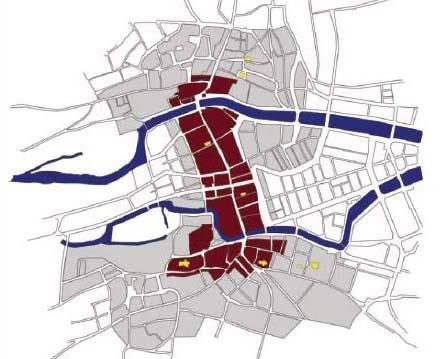
Environmental Impact Statement 10-4Lower Lee (Cork City) Drainage Scheme in association with Monuments and Places (RMP) and the placing of Preservation Orders and Temporary Preservation Orders on endangered sites. Section 12 (1) of the National Monuments (Amendment) Act of 1994 makes provision for the establishment and maintenance of a Record of Monuments and Places (RMP) deemed to have cultural heritage potential. The record replaced the earlier Sites and Monuments Record (SMR) and provides a list of monuments and relevant places with accompanying maps. All sites recorded on the RMP receive statutory protection under the National Monuments Act 1994 and any work undertaken at these sites must be licenced by the National Monuments Service. Section 3 of the National Monuments (Amendment) Act of 1987 makes specific provisions for the protection of shipwrecks over one hundred years old and underwater archaeological objects. The RMP sites within close vicinity to the proposed scheme are identified in Section 10.3.4 of this chapter. The published inventory descriptions of RMPs referred to in the chapter are presented in Appendix 10C and location maps are provided in Appendix 10D. It is also possible that unrecorded archaeological sites or artefacts remain buried below the existing ground surfaces or within river sediments in the vicinity of the scheme. The Cork City Development Plan 2015-2021 defines the extent of the primary and secondary zones of archaeological potential for Cork city (Figure 10.1). It also outlines a wide range of policies and objectives in relation to the protection of the archaeological heritage within the city and examples relative to the present assessment include the following: Objective 9.7: Preservation of archaeological remains in-situ In accordance with national policy (and in the interests of sustainability) impacts on the buried archaeological environment should be avoided where possible. Objective 9.16: Large-scale Development (outside the boundaries of a RMP) Outside the Zone of Archaeological Potential of a RMP, where in the opinion of the City Council a development involves major ground disturbance; archaeological conditions may be applied particularly in the vicinity of known monuments. Objective 9.18: Industrial Archaeology All development proposals for industrial buildings and sites of industrial archaeological importance must be accompanied by an archaeological assessment of the building(s) and their surrounding environment. Retention and/or incorporation of industrial buildings will be encouraged. Where in exceptional circumstances demolition is permitted, a detailed building report will be required. Objective 9.20: Underwater Archaeology All development proposals which will impact on riverine, intertidal and sub-tidal environments should be accompanied by an archaeological assessment. 9.29 Protection of Underwater Archaeology Under the National Monuments (Amendment) Act 1930-2004 all shipwrecks over one hundred years, underwater archaeological structures, features and objects are protected. Cork was built on estuarine islands in the marshy valley of the River Lee at a point where it formed a number of waterways. The marshland areas to the east and west of the medieval city were reclaimed in the eighteenth century. It is Environmental Impact Statement 10-5
Lower Lee (Cork City) Drainage Scheme                                                     in association with

   possible that archaeological riverine-related features may survive. These may take the form of walkways,
   fish-traps, timber jetties or simple mooring posts.
The City Council have also published the South Docks Local Area Plan 2008 and the North Docks Local
Area Plan 2005. These outline the following policy objectives for the protection of the archaeological and
architectural heritage resource within the dockland areas in the east end of the city centre:

   South Docks Local Area Plan
   Archaeological monitoring should precede any development involving earth removal. A licensed
   archaeologist shall be employed by the developer to monitor such works, reporting to the state institutions
   as prescribed by the National Monuments Acts. The requirement for archaeological monitoring will be
   dependent on the size, scale and nature of the proposed development. In particular, archaeological
   monitoring will be required for any bulk excavation. Any dredging or excavation work proposed for the
   river or adjacent to the riverfront will also require archaeological monitoring. The City Council shall outline
   the process to be followed
   North Docks Local Area Plan 2005
   The North Docks plan area is outside the zones of archaeological importance. However, since it is largely
   located on reclaimed river marsh, there may be a requirement for survey and monitoring where a
   development will involve large-scale ground disturbance. Cork’s pre-eminence as an industrial centre in the
   late 18th and 19th centuries has created the most tangible record of historic archaeological remains in the
   North Docks. Many of the quay walls, shipping offices, associated warehouses and yards still survive as do
   the most significant structures associated with the development of the railway from the 1840s to the
   present. The former ship-building and repair yards are now only to be found in the extreme eastern end of
   the area, and are consequently of even more significance because of the rarity of what was once an
   important industry in the city. The area bounded by Penrose Quay, Clontarf St., Railway St. has a
   distinctive character reflecting its historical development as a centre for shipping offices and warehouses
   (following the construction in the early 19th C of the new deeper quay along Penrose Quay). It is worth
   noting that despite much later rebuilding; the Penrose quay wall contains large sections of fine cut
   limestone, which are of significance.

The Cork County Council Development Plan 2014 outlines the following policy objectives for the protection
of the archaeological resource:
   HE 3-1: Protection of Archaeological Sites
   a) Safeguard sites and settings, features and objects of archaeological interest generally.
   b) Secure the preservation (i.e. preservation in situ or in exceptional cases preservation by record) of all
   archaeological monuments including the Sites and Monuments Record (SMR) (see www.archeology.ie) and
   the Record or Monuments and Places as established under Section 12 of the National Monuments
   (Amendment) Act, 1994, as amended and of sites, features and objects of archaeological and historical
   interest generally.
   HE 3-2: Underwater Archaeology

Environmental Impact Statement                                                                                  10-6
Lower Lee (Cork City) Drainage Scheme                                                   in association with

   Protect and preserve the archaeological value of underwater sites and associated features. In assessing
   proposals for development, the Council will take into account the potential underwater archaeology of
   rivers, lakes intertidal and subtidal environments.
   HE 3-3: Zones of Archaeological Potential
   Protect the Zones of Archaeological Potential (ZAPs) located within historic towns and other urban areas
   and around archaeological monuments generally. Any development within the ZAPs will need to take
   cognisance of the potential for subsurface archaeology and if archaeology is demonstrated to be present
   appropriate mitigation (such as preservation in situ/buffer zones) will be required.
   HE 3-4: Industrial Archaeology
   Protect and preserve the archaeological value of industrial and post-medieval archaeology such as mills,
   lime kilns, bridges, harbours, penal chapels and dwellings. Proposals for refurbishment, works to or
   redevelopment / conversion of these sites should be subject to assessment.
   12.3.16: Where archaeological materials are found appropriate mitigation measures shall be put in place.
   Preservation in situ should generally be the presumed option and only compelling reasons can justify
   preservation by record.
   12.3.19: Previously unidentified archaeological sites may be uncovered during drainage schemes or road-
   making. Archaeological deposits which may be damaged by development must be recorded.

The Built Heritage Resource
Protection of the built heritage resource is provided for through a range of legal instruments that include
the Heritage Act, 1995, the Architectural Heritage (National Inventory) and National Monuments (Misc.
Provisions) Act, 1999, and the Local Government (Planning and Development) Act 2000. Under the Local
Government (Planning and Development) Act, 2000, all Planning Authorities are obliged to keep a
‘Record of Protected Structures’ of special architectural, historical, archaeological, artistic, cultural,
scientific, social or technical interest. As of the 1st January 2000, all structures listed for protection in
current Development Plans, have become ‘protected structures’. Since the introduction of this legislation,
planning permission is required for any works to a protected structure that would affect its character. If a
protected structure is endangered, planning authorities may issue a notice to the owner or occupier
requiring works to be carried out. The Act contains comprehensive powers for local authorities to require
the owners and occupiers to do works on a protected structure if it is endangered, or a protected structure
or a townscape of special character that ought to be restored. The following section presents the legal
and policy environment that relate to the protection of the architectural heritage resource and details on
the elements of this resource within close vicinity to the scheme are provided in Section 10.3.4 of this
chapter.
The Heritage Act 1995 protects all heritage buildings owned by a local authority from damage and
destruction. Section 2.1 of the Act describes architectural heritage as ‘all structures, buildings, traditional
and designed, and groups of buildings including streetscapes and urban vistas, which are of historical,
archaeological, artistic, engineering, scientific, social or technical interest, together with their setting,
attendant grounds, fixtures, fittings and contents, and, without prejudice to the generality of the foregoing,
includes railways and related buildings and structures and any place comprising the remains or traces of

Environmental Impact Statement                                                                                10-7
Lower Lee (Cork City) Drainage Scheme                                                        in association with

any such railway, building or structure’. The Heritage Council was also established under the Heritage Act
in order to promote the interest in, knowledge and protection of Irish heritage, including the architectural
resource.
The Local Government (Planning and Development) Act 2000 obliges planning authorities to keep a
Record of Protected Structures (RPS) of special architectural, historical, archaeological, artistic, cultural,
scientific, social or technical interest. As of the 1st January 2000, all structures listed for protection in
current Development Plans, have become ‘protected structures’. Since the introduction of this legislation,
planning permission is required for any works to a protected structure that would affect its character. If a
protected structure is endangered, planning authorities may issue a notice to the owner or occupier
requiring works to be carried out. The Act contains comprehensive powers for local authorities to require
the owners and occupiers to do works on a protected structure if it is endangered, or a protected structure
or a townscape of special character that ought to be restored. The protected structures within close vicinity
to the proposed scheme are identified in Section 10.3.4 of this chapter. The County and City Development
Plans do not provide location maps for these structures.
The Architectural Heritage Act 1999 (National Inventory) requires the Minister to establish a survey to
identify, record and evaluate the architectural heritage of the country. The function of the National
Inventory of Architectural Heritage (NIAH) is to record all built heritage structures within the Republic of
Ireland. While inclusion in a NIAH inventory does not provide statutory protection to a structure the
inventory is used to advise local authorities on compilation of a Record of Protected Structures (RPS) as
required by the Local Government (Planning and Development) Act, 2000. The buildings in the close
environs of the proposed scheme which are included in the NIAH are identified in Section 10.3.4 of this
chapter. The published inventory descriptions of the NIAH features referred to in the report are presented
in Appendix 10C and location maps are presented in Appendix 10D.
The Cork City Development Plan 2015-2021 contains a wide range of policies and objectives in relation
to the protection of the architectural heritage within the city and examples relative to the present
assessment include the following:

   9.23: Record of Protected Structures
   The Council will maintain a Record of Protected Structures, which shall include structures or parts of
   structures and their curtilage which are of special architectural, historical, archaeological, artistic, cultural,
   scientific, social or technical interest, and which it is an objective to protect
   Objective 9.28: Protection of NIAH and other structures of built heritage interest
   The City Council as planning authority aims to protect structures of built heritage interest.
   9.61: Other Elements of Built Heritage
   Of immense importance are the 19th century elements associated with the north and south channel.
   Important features include quay walls, bollards, kerbing etc.

The Architectural Conservation Areas (ACAs) within Cork City are defined in the City Development Plan
2015-2021 as a place, area, group of structures or townscape that is of special architectural, historical,

Environmental Impact Statement                                                                                     10-8
Lower Lee (Cork City) Drainage Scheme                                                             in association with

archaeological, artistic, cultural, scientific, social or technical interest or contributes to the appreciation of
protected structures. The purpose of these designations is, in part, to ensure uniformity in approach to a
wide variety of individual planning applications within highly evolving urban areas. The city centre has
been sub-divided into a number of ACAs in the Development Plan and the examples that contain river
frontages and quaysides in the vicinity of the scheme are: South Parish, Patrick’s Hill, Shandon and Lower
Glanmire. The scheme also extends through the following areas that have been designated as Proposed
ACAs: Sunday’s Well, Mardyke, Albert Quay, North Mall and University College Cork. The City
Development Plan provides maps for each of the ACAs and their locations are presented in Appendix
10D.
The following objectives published in the Cork City Development Plan 2015-2021 outline the City Council’s
objectives in relation to proposed development applications within ACAs.
   Objective 9.29: Architectural Conservation Areas
   To seek to preserve and enhance the designated Architectural Conservation Areas in the City.
   Objective 9.30: Demolition in Architectural Conservation Areas
   Demolition of structures and parts of structures will in principle only be permitted in an Architectural Conservation
   Area where the structure, or parts of a structure, are considered not to contribute to the special or distinctive
   character, or where the replacement structure would significantly enhance the special character more than the
   retention of the original structure.
   Objective 9.31: Recording of Structures in Architectural Conservation Areas
   Where in exceptional circumstances a structure or a part of a structure which is considered to contribute to the special
   character of the area, is permitted to be demolished, it should first be recorded prior to demolition, and where
   appropriate should be monitored during demolition.
   Objective 9.32: Development in Architectural Conservation Areas
   Development in ACAs should take account of the following:
   - Works that impact negatively upon features within the public realm such as paving, railings, street furniture, kerbing
   etc. shall not be generally permitted;
   - Acceptable design, scale, materials and finishes for new developments;
   - Original materials and methods of construction should be retained. For example, timber barge boards, windows and
   doors should not be replaced with PVC, original roofing material types should be retained along with original forms
   and locations of openings etc.;
   - Features of historic or architectural value should not be removed.
   9.60: Other Elements of Built Heritage
   Many non-structural elements such as curtilage features, historic gardens, stone walls, historic ironwork, historic
   plaques and street furniture (post boxes, horse troughs etc.) contribute to our built heritage. These items are often an
   integral part of the urban landscape or provide significant historic references which contribute to the character of an
   area. These elements can be vulnerable to needless, partial or total destruction and theft as well as poor
   reconstruction due to carelessness and a lack of awareness.

Environmental Impact Statement                                                                                          10-9
Lower Lee (Cork City) Drainage Scheme                                                   in association with

The Cork County Council Development Plan does not designate any ACAs within the environs of the
proposed scheme. It does present a number of objectives to ensure the protection of the architectural
heritage resource within the County and these include:
   HE 4-1: Record of Protected Structures
   d) Ensure the protection of all structures (or parts of structures) contained in the Record of Protected
   Structures.
   e) Protect the curtilage and attendant grounds of all structures
   HE 4-2: Protection of Structures on the NIAH
   Give regard to and consideration of all structures which are included in the NIAH for County Cork, which
   are not currently included in the Record of Protected Structures, in development management functions.
   HE 4-3: Protection of Non- Structural Elements of Built Heritage
   Protect important non-structural elements of the built heritage. These can include designed gardens/garden
   features, masonry walls, railings, follies, gates, bridges, and street furniture. The Council will promote
   awareness and best practice in relation to these elements.

10.3.3   Desktop Study
The following section presents the results of a desktop study on the general archaeological, architectural
and historical heritage within the environs of the proposed scheme and was undertaken in order to inform
the assessment of the potential impacts. More detailed information on site specific areas is then presented
in the section describing the cultural heritage resource based on the areas covered by the individual
scheme drawings (Section 10.3.4).
In general, the proposed scheme extends eastwards from the Innishcarra area through low-lying lands
dominated by pasture farmland on the outskirts of Ballincollig and then continues into the western edge of
the city suburbs. The scheme has been designed, where feasible, to avoid all recorded archaeological sites
and architectural heritage structures within the lands to the west of the city. It then follows the river as it
branches into the north and south channels in the Sunday’s Well and Western Road areas and then
extends through the 19th century suburbs before reaching the city centre. The present river channels within
the city centre are delimited by the 19th century quay sides constructed along the margins of infilled
ground reclaimed during the 18th and 19th centuries in the marsh lands outside the medieval city walls. As
detailed below, a wide range of archaeological investigations have been undertaken within the reclaimed
ground adjacent to the existing channels and these have typically uncovered thick deposits of dumped
soils that, to date, have produced little of archaeological significance. The design phase of the scheme
involved a process of ongoing consultations between the design team and the City Council, including the
Conservation and Archaeological Officer, in relation to proposed design of works along the city quays.
Until the recent identification of Palaeolithic human remains amongst samples recovered in the early 20th
century from a cave site in County Clare, the earliest recorded evidence for human settlement in Ireland
dated to the Mesolithic period (7000–4000 BC) when groups of hunter-gatherers lived on the heavily
forested island. While these Mesolithic groups did not construct settlements or monuments that have left
any above ground traces, their sites can often be identified during ground excavations and by scatters of

Environmental Impact Statement                                                                                10-10
Lower Lee (Cork City) Drainage Scheme                                                  in association with

worked flints in ploughed fields. The Neolithic period (4000-2400 BC) began with the arrival and
establishment of agriculture as the principal form of economic subsistence, which resulted in more
permanent settlement patterns. As a consequence of the more settled nature of agrarian life, new site-
types, such as more substantial rectangular timber houses and various types of megalithic tombs, begin to
appear in the archaeological record during this period. While there are no recorded Mesolithic or
Neolithic sites within close vicinity to the proposed scheme, riverine environments were utilised as both food
and transport resources since the earliest known arrival of human settlers on the island. As noted above,
the settlement sites of both periods were timber-built and leave no above ground traces but sub-surface
remains are often uncovered during ground works during developments. The sub-surface remains of
Neolithic settlements within the environs of the Lee valley were uncovered during archaeological
investigations on the route of the Ballincollig bypass, approx. 2km to the south of the study area.
Metalworking arrived in Ireland with the advent of the Bronze Age period (c. 2400–500 BC). This new
technology introduced a new artefactual assemblage into the Irish archaeological record and this period
was also associated with the construction of new monument types such as standing stones, stone rows, stone
circles and fulachta fiadh. The development of new burial practices meant that the construction of funerary
monuments such as cairns, barrows, boulder burials and tumuli or cists was fairly common during this
period. The later first millennium BC and the early centuries AD, which comprise the Irish Iron Age, form the
most obscure period in the Irish archaeological record. While, there is general agreement that the
transition to an iron-working technology was a significant factor in the eventual demise of bronze working
and was associated with societal changes, the nature and form of this transition in Ireland is far from clear.
The only recorded potential Bronze Age site in close proximity to an element of the proposed scheme is a
fulacht fiadh located in a green field area within Coolroe townland at a distance of 150m to the east of
proposed works. As with the settlement sites of the early prehistoric period, the timber-built Bronze and
Iron Age settlement sites tend not leave any surface traces although the discovery of approx. sixteen
Bronze Age sites beneath the topsoil on the route of the Ballingcollig Bypass indicates a strong settlement
pattern within the landscape surrounding the proposed scheme during this period. There are no recorded
Iron Age sites within the close environs of the proposed scheme but a number of sites uncovered on the
route of the Ballincollig bypass have been dated to this period. The ‘Cork Horns’ artefact discovered
reclamation deposits near the south jetties in the Victoria Road area of Cork city during early 20th century
ground works also demonstrate Iron Age activity in the area now occupied by the city centre. The horns
bear ornament in the La Tène style which is typical of the later Iron Age period and they were probably
once attached to a leather helmet which did not survive (O’Kelly 1961).
The early medieval period in Ireland began with the introduction of Christianity and continued up to the
arrival of the Anglo-Normans in the 12th century (c. 400–1169 AD). The establishment of the Irish church
was to have profound implications for political, social and economic life on the island and is attested to in
the archaeological record by the presence of church sites and associated features such as formal burial
sites and holy wells. The early medieval church sites were morphologically similar to ringforts but are often
differentiated by the presence of features such as church buildings, graves, stone crosses and shrines. A
number of the townland names in the general vicinity of the proposed scheme record historical associations
with early ecclesiastical activity, i.e. Bishops-Mill-Land, Ballinanaspig, Shanakiel and Gillabbey townlands.
While this period saw the emergence of the first phases of urbanisation around both the large monasteries
and Hiberno-Norse ports the dominant settlement pattern of the period remained rural-based. A detailed
account of the origins and development of the ecclesiastical and secular settlements at Cork city are

Environmental Impact Statement                                                                               10-11
Lower Lee (Cork City) Drainage Scheme                                                in association with

beyond the scope of the present study but a summary account follows hereafter. The beginning of the
urban settlement appears to have developed around an ecclesiastical centre close to the present day
location of St. Finbarr’s Cathedral in the southern suburbs. The earliest mention of the monastery in the
annals is in AD 682 when the death of Suibne, the abbot of the monastery, was recorded. The first account
of Viking raiders in Cork dates to AD 821 and by the middle of the 9th century they had established a
settlement centred on the river banks around the South Gate area. This initial settlement entailed localised
reclamation works along the marshy lands on the river’s edge. Over the course of the following centuries
the Viking settlers inter-married with the native Irish and can be more accurately described as Hiberno-
Norse as the period progressed. The settlement was under the control of the McCarthys and had already
begun to expand into a trading port by the time the Anglo-Normans arrived in 1177 AD.

    Figure 10.1 Location of Primary (red) and Secondary (grey) Zones of Archaeological Potential
                                          (Cork City Council)

The arrival and conquest of large parts of Ireland by the Anglo-Normans in the late 12th century broadly
marks the advent of the Irish late medieval period, which continued up until the beginning of the post-
medieval period in c.1550. The Anglo-Normans began construction of a masonry city wall in the decades
following their arrival in Cork. The medieval walled city gradually incorporated two riverine islands on the
footprint of the present day North and South Main Streets, which comprised the central spine of the
medieval city. The two islands were initially separated by a channel which was linked by a bridge

Environmental Impact Statement                                                                             10-12
Lower Lee (Cork City) Drainage Scheme in association with formerly located at the junction between North/South Main Streets and Bridge Street while the river channels encircled the outside of the city walls. The walled city was accessed by timber bridges at the North and South Gates and these were gradually replaced by stone bridges during the 18th century. The walls went through a number of phases of disrepair and rebuilding throughout the medieval period and this was largely due to the instability of the underlying estuarine muds. With the development of artillery during the post-medieval period the use of walls as city defences became largely redundant. After the siege of 1690 the Cork walls were allowed to fall into disrepair and sections began to be actively demolished. There are very few surviving above ground traces of the city walls although sub-surface remains still survive under the modern streetscape. Archaeological excavations along the riverside sections of the city wall have demonstrated that it is set back from the existing quay walls beneath adjacent buildings and streets. The excavation of the riverside plot to the east of the South Gate Bridge uncovered the remains of the city wall at a distance of 12.5m to the north of the existing quay wall (Ni Loingsigh 2004). The RMP records a number of individual sites within the medieval city and the entire core settlement is encompassed under the entries for the ‘historic town’ (CO074-034001-) and the ‘town defenses’ (CO074-034002-). The proposed scheme does not contain any elements that extend onto the footprint of the city walls or within the interior of the medieval city. While the walls no longer physically delimited the city by the start of the 18th century, the settlement was still concentrated in the overcrowded medieval core of North and South Main Streets although suburbs had begun to extend up the hillsides in areas now occupied by Shandon to the north and Barracks St. to the south. The areas that now form the main thoroughfares of the modern city centre, such as Patrick’s Street, Grand Parade and South Mall, were still occupied by open river channels that extended through the undeveloped marshy islands to the east of the medieval city. The modern streetscape of the existing city centre began to form during the 18th century following the gradual reclamation of the eastern marshes. These were initially linked to the city by bridges over the channel outside the east wall which was then infilled to create Grand Parade and Cornmarket Street. The Corporation issued development leases to encourage the reclamation and development of the surrounding marshlands and also gave permission for the construction of the bridges over the channel to the east of the city. By the start of the 19th century the extensive reclamation and culverting works in the channels and creeks around the former marsh islands to the east and west of the medieval city meant that only the existing north and south river channels survived. As extensive works were being made to reclaim the marsh islands, concurrent works were commissioned to improve shipping access to the quays developing within the reclaimed areas outside the walls. The river channels had silted up by the start of the 1800s when water depths of as little as 4 feet at low tide were recorded and this was occurring at a time when ships with increasing greater drafts were being built (Beecher 1971). Given the importance of the harbour trade to both the city and its farming hinterland, a great expense was invested during the subsequent decades on the improvement of the both the channels and quays. The works undertaken during the 18th and 19th centuries were immense in scale and have been usefully summarised in recent decades (e.g. Rynne 1999 & Leland 2001) and the following account is largely based on these sources. As noted by Rynne (1999, 197), while the deep channels of the sheltered lower Cork harbour were well suited for shipping traffic, this attribute steadily decreased in the increasingly shallower approaches to the city where water depths as shallow as three feet were recorded. Prior to the early 19th century the construction and maintenance of the quay walls was undertaken on a piecemeal basis and to varying quality by private property owners and were described by Alexander Nimmo in 1815 as “imperfect masses of rubble stone” (Ove Arup 1976). Much of the focus of the initial Environmental Impact Statement 10-13
Lower Lee (Cork City) Drainage Scheme                                                in association with

phase of navigation improvement works was the construction of a “navigation wall” (also known as “the
New Wall”) along the south bank of the river channel initially extending eastward for some 800 yards
from the area now east of Albert Quay. The navigation wall was intended to regularise the current in the
river channel and to allow vessels to be drawn up-stream by horses. As vessel sizes increased in size it
became necessary to dredge the upper harbour and city channels in order to facilitate access to the city.
The poor condition of the city quays formed a constant constraint to this work as the poorly built walls
were built directly on top of estuarine muds and dredging led to their collapse. The mooring capacity of
the quays was further constrained by the fact that sections of the poorly bonded rubble-stone quay walls
were prone to collapse when ships were tethered to them.
The formation of the Cork Harbour Commissioners in 1813 concentrated responsibility for the improvement
and maintenance of the shipping channels and quays into one organisation. During the following decades
the Commissioners instigated an extensive programme of repairing and re-building the quays in limestone
ashlar construction and this included the insertion of 8,000 timber toe-piles driven to depths of 21 feet in
order to facilitate dredging close to the quays. Lewis (1837) records that the Commissioners spent total of
£34,389, raised from harbour fees, between 1827 and 1834 on the improvement of the city quays. Once
the quays were in a stable condition the river channels were extensively dredged and the extracted
material was used to reclaim areas of slob-land, including the City Park area behind the Navigation Wall.
Timber wharfs began to be constructed along a number of the quays in the second half of the 19th
century, including Albert, Union, Victoria, Patrick’s and Penrose Quays. These features extended the
docking location into the channel and allowed dredging to be carried out to increased depths at safer
distances from the quay walls. In 1874 timber wharves were added to the south jetties. There were seven
jetties constructed, each 43 ½ feet wide and initially separated by 120 feet of clear space which were
subsequently filled in (Beecher 1971, 142).
The existing city quay walls are in the ownership of Cork City Council and they, along with their associated
mooring features, are typically of 19th century date. While the survival of these masonry features in a
riverine location for two centuries is a testament to the engineering skill involved in their design and
construction, sections have required extensive programmes of remedial works in recent decades. An
extensive program of quay repairs and complete rebuilding of sections along Albert, Penrose and
Anderson’s Quays was commissioned by the Council in the late 20th century and this was, in part, instigated
by a collapse of a section of the quayside along Albert Quay during the 1970s. The section of quay walls
along the east end of Lapp’s Quay was removed and later reconstructed as part of an early 2000s
commercial development along the quayside.
Although the various quays and associated features, such as river steps, mooring posts, docking rings and
wharfs, within the city are not listed in the RMP or RPS, many have been included in the NIAH and these
are identified in Section 10.3.4. The city centre has been sub-divided into a number of Architectural
Conservations Areas (ACAs) in the Development Plan and the ACAs that encompass, or are adjacent to,
the riverside in the environs of the proposed scheme are: North Main St, South Parish, Patrick’s Hill,
Shandon, Blackpool and Lower Glanmire. As previously noted, the Cork City Council Development Plan
(2015-2021) states that “of immense importance are the 19th century elements associated with the north and
south channel. Important features include quay walls, bollards, kerbing, etc”.
As the city expanded outside the medieval core the two bridge crossings at the former medieval gates no
longer sufficed to connect the new areas and new bridges within the reclaimed sections of the city began
to be constructed from the 18th century onwards. Ferry crossings were an important element of the social

Environmental Impact Statement                                                                             10-14
Lower Lee (Cork City) Drainage Scheme                                                 in association with

and economic life of Cork during the 17th and 18th centuries as they provided for the transport of
passengers, livestock and goods in the period before the construction of many of the historic city bridges.
The ferry operators were understandably recorded as objectors to the proposed construction of Patrick’s
Bridge and raised a petition that was presented to parliament in 1785 (Lenihan 2009). Despite their
protestations the bridge was granted permission and, although they were compensated, they were also
notified that if they did not dispose of their ferry rights then the operations would be valued and
compulsorily acquired (ibid.). Nonetheless, the use of ferries between the city quays continued on, albeit, a
much smaller scale into the 20th century.
The river bridges in Cork city centre are owned by Cork City Council and the main structural types are
stone arch, metal (steel and cast iron) and concrete. The stone arch city bridges within the vicinity of the
scheme were constructed between 1713 and 1902. Three of the metal bridges were constructed between
1875 and 1911 while a modern example, Cornmarket Bridge, was constructed in 2004. The concrete
road bridges were built between 1961 and 1999. The Cork City Council RPS includes 13 of the bridges
within the study area (Table 10.1) and one of these, South Gate Bridge, is also listed in the RMP (CO074-
034012-). A number of the bridges within the city are also included in the NIAH (Table 10.1). The Cork
County Council RPS includes two bridges in close vicinity to the scheme in the area to the west of the city
and both of these are also listed in the RMP, i.e. the road bridges at Inniscarra (PS00458 / RMP CO073-
045----) and at Carrigrohane Beg (PS00457 / RMP CO073-045----). The County Council RPS also
includes a weir in the section of the River Lee (PS00459) to the east of Inniscara Bridge. This appears to
be associated with the Ballincollig Gun Powder Mills on the south shore of the river, which is listed in the
RMP (CO073-043----) and is a national monument in the ownership of Cork County Council. There are no
works proposed within the Gun Powder Mills property or in the vicinity of the associated weir.
In general, the structural composition of bridge structures provides a good indication of the engineering,
construction and transport practices dominant at the time it was built and this holds true for the examples
within the study area. For example, many of the narrower stone arch bridges were constructed in the 18th
and 19th centuries when pedestrian and horse-drawn traffic was common; while the majority of the metal
bridges date to the late 19th and 20th centuries and include two rail bridges that reflect the dominant
transport system in that period. The advent of the widespread use of private motor cars during the 20th
century resulted in the construction of more than eleven bridges over the channels on either side of the city
island (O’ Callaghan 2012, 125). These were typically of concrete construction and comprised both multi-
lane road bridges to accommodate car traffic and pedestrian bridges to encourage a concurrent increase
of foot traffic in the rapidly congesting streets and to serve the expanding 19th century suburbs on the
outskirts of the former medieval core.
It is noted that the flood relief works have been largely designed to avoid or minimise impacts on the
bridges within the study area and the summary descriptions within this chapter are intended, nonetheless,
to provide a context for development of these features over the river channels in recent centuries.
The oldest surviving bridge in the city comprises elements of the three-span South Gate Bridge, the upriver
end of which dates to 1713, and the next oldest is Clarke’s Bridge erected in 1766. The early maps of the
city show that it was connected to the north and south by timber bridges (North and South Gate)
connecting to the walled city during the 16th and 17th centuries while a series of later bridges were
constructed over the channels between the walled area and the reclaimed marshes to the east. While
there are no extant remains of these early Cork bridges the Council Books of Cork Corporation does

Environmental Impact Statement                                                                              10-15
Lower Lee (Cork City) Drainage Scheme                                                in association with

contain the following records relating to their construction and maintenance (from O’Keeffe, P.J. &
Simmington, T. 1991):
        Early 1600s – mention of taxes used for the repair of the city walls and bridges
        1635-36 – attempt to construct stone bridge commences at North Gate but followed by
        references to difficulties encountered with building stone bridge in silty river bed.
        14 Nov 1639 – Council Books states “the North Bridge shall be substantially built with sound and
        good timber and that the same shall be well paved over with stone, gravel and sand according as
        the best bridges of that nature and quality within the Kingdom of Ireland…”
        1639 – reference to residents of East Marsh being given permission to erect a bridge at Kearle’s
        Key provided it was at their own cost
        1697 – funding raised for repair of North Bridge
        1698 – Captain Dunscombe given liberty to build at his own cost a stone bridge from Tuckey’s
        Quay to the great marsh as long as it had an arch high and broad enough to allow the passage
        of lighters at spring tide
        Early 1700s – references to other bridges extending from the area of the walled city to the
        surrounding marshes. These references demonstrate the role of private enterprise in bridging the
        former channels outside the city wall in order to facilitate the expansion of the city into the
        surrounding marshy islands. The records also convey the Corporation’s instructions that these
        bridges were not to impinge on the navigation of the channels.
        7th May 1711 – Council book records that it was agreed “that a new stone bridge be built over
        the north river where the old timber bridge is”
        1712 – record of purchase of oak timber piles for the support of the North and South Bridges.
        1713 - Agreement with Thomas Chatterton, mason, and John Coltsman, stone cutter, to build the
        South Bridge and refers to use of tarass material left over from North Bridge. Tarass was a
        ground basaltic rock, imported from Holland, which was mixed with lime to form a hydraulic
        mortar.
An attempt to provide a definitive descriptive account of the origins and design of the existing bridge
infrastructure within the study area is beyond the scope of the present assessment and the summary
descriptions of each structure presented hereafter are sourced from the following publications: National
Inventory of Architectural Heritage, The Industrial Archaeology of Cork City and its Environs (Rynne 1999),
Heritage Bridges of County Cork (Tobar Archaeology 2013) Irish Stone Bridges: History and Heritage
(O’Keeffe & Simmington 1991) and most especially Where Bridges Stand: The River Lee Bridges of Cork
City (O’ Callaghan 2012). Further details on the bridge infrastructure within the vicinity of the scheme are
presented in the ADCO survey report (Appendix 10A).

Environmental Impact Statement                                                                             10-16
Lower Lee (Cork City) Drainage Scheme in association with
Table 10.1 Bridge structures in the vicinity of the proposed scheme
Bridge Status Details
Patrick’s Bridge NIAH 20513133 The existing St. Patrick’s Bridge was opened in 1861 to a design by Sir John Benson.
This three-span stone-arched structure replaced the previous stone bridge, opened in
RPS (no ref.) 1789, which collapsed during floods in 1853. Cork Corporation borrowed funds for
the reconstruction of the replacement bridge through the 1856 Cork Bridge and
Waterworks Act at a cost of £19,000. The foundations are 14’ below the low water
line and support piers are formed with iron reinforced concrete. The main base and
under-works were constructed of Foynes Limestone with good quality local limestone
for the superstructure, which is built of finely jointed ashlar. The foundation stone to the
north-east abutment is a two-tonne block of Foynes limestone with a glass vase
inserted, containing coins and scrolls of the mid 19th century and the names of local
dignitaries and building contractors. Effigies of Saint Patrick, Saint Bridget, Neptune
and three sea goddesses adorn the key-stones of each elliptical arch and were
sculpted by Scannell’s of Douglas St. Most of the original moulded stone balusters
have been replaced with cast, reinforced concrete as part of various reconstruction
works in 1961 and 1981. Cast iron gas lamps were mounted on stone pedestals on
the parapets in 1861 and have since been replaced with electric lighting. The traffic
lights on the north end are mounted on the old gas lighting poles, from which the
lanterns are missing. The bridge presently carries an asphalt-covered road with 3.2m
wide footpaths of concrete paving flags on either side.
South Gate Bridge RPS 328 The original part of South Gate Bridge was approx. 15 ft wide. There are two
relatively thin 4ft 5in. river piers. The central arch is 26 ft span with a three-centred
RMP CO074- intados. The 21 ft and 23 ft side arches are also three-centred. The ring stones are
03412 properly wedge-shaped voussoirs… Brunicardi states that Alexander Deane,
architect, designed the downriver extension in 1824”… A council book entry of 1745
states that the bridge was greatly endangered by rubbish being thrown in the channel
and the water bailiff was directed that “no boat take ballast in any other area until
the rubbish was removed. (O’Keeffe & Simmington 1991)
Clarke’s Bridge RPS 026 Clarke’s Bridge was designed by Thomas Hobbs and, when opened in 1776, it was
the largest span stone arch in Ireland at 68 feet although it was superseded by
NIAH 20503247 Thomas Ivory’s bridge in Lismore ten years later. Its design may have been influenced
by William Edward’s 1750s Pontypridd Bridge in Wales over the River Taft. The main
arch is of limestone while the rest of the structure is built of red-clay slate. The low
parapet walls are built of red sandstone with limestone coping. A brick surrounded
opening with steel lintel has been inserted on the south west parapet wall although its
purpose is unclear. The quay parapet walls to the north west abutment have been
truncated and the stone wall replaced with steel railings. Corrugated steel sheeting
has been bolted to the north east spandrel presumably to protect the bridge from any
accidental damage from construction works taking place on the adjacent quayside.
The bridge was refurbished and widened to the east in 1993 and presently
accommodates a single vehicular lane. There are concrete footpaths on either side of
the carriageway. Some inappropriate repairs have been made to the parapet coping
of this bridge and adjacent quay walls, both where stone was replaced with concrete
blocks and where damage has been repaired with an unsuitable stone indent.
Alderman O’ Reilly RPS 814 (NIAH) This double-arch stone road bridge was built c. 1770, with brick U-shaped
Bridge cutwater. Ashlar limestone voussoirs with rubble stone walls and parapet. This bridge
NIAH 20500786 was built in the late 18th century to connect Reilly's Marsh with the North Mall and was
later incorporated into the North Mall Distillery which was founded in 1779.
Environmental Impact Statement 10-17You can also read