Chloorkop, Gauteng Baseline and Impact Assessment: Proposed Chloorkop Landfill Expansion - SLR Consulting
←
→
Page content transcription
If your browser does not render page correctly, please read the page content below
Baseline and Impact Assessment: Proposed
                Chloorkop Landfill Expansion

                  Chloorkop, Gauteng

                           DATE

                          June 2019

                           CLIENT

Prepared for:                          Prepared by:
SLR Consulting                         The Biodiversity Company
Matthew Hemming                        420 Vale Ave. Ferndale, 2194
                                       Cell: +27 81 319 1225
                                       Fax: +27 86 527 1965
                                       info@thebiodiversitycompany.com
                                       www.thebiodiversitycompanycom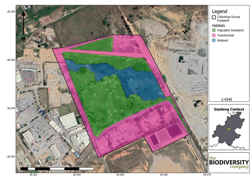
Biodiversity Baseline and Impact Assessment

Chloorkop Landfill Expansion

                         Baseline and Impact Assessment: Proposed Chloorkop Landfill
   Report Name
                                                 Expansion

   Submitted to

                               Martinus Erasmus
   Report Writer
   (GIS, Botany)   Martinus Erasmus (Cand Sci Nat) obtained his B-Tech degree in Nature Conservation in
                   2016 at the Tshwane University of Technology. Martinus has been conducting EIAs, basic
                   assessments and assisting specialists in the field during his studies since 2015.

                               Lindi Steyn
   Report Writer
                   Lindi Steyn has a PhD in Biodiversity and Conservation from the University of
                   Johannesburg. She specialises in avifauna and has worked in this specialisation since
                   2013.

                             Andrew Husted

                   Andrew Husted is Pr Sci Nat registered (400213/11) in the following fields of practice:
 Report Reviewer   Ecological Science, Environmental Science and Aquatic Science. Andrew is an Aquatic,
                   Wetland and Biodiversity Specialist with more than 12 years’ experience in the
                   environmental consulting field. Andrew has completed numerous wetland training
                   courses, and is an accredited wetland practitioner, recognised by the DWS, and also the
                   Mondi Wetlands programme as a competent wetland consultant.
                   The Biodiversity Company and its associates operate as independent consultants under
                   the auspice of the South African Council for Natural Scientific Professions. We declare
                   that we have no affiliation with or vested financial interests in the proponent, other than
                   for work performed under the Environmental Impact Assessment Regulations, 2014 (as
    Declaration    amended). We have no conflicting interests in the undertaking of this activity and have
                   no interests in secondary developments resulting from the authorisation of this project.
                   We have no vested interest in the project, other than to provide a professional service
                   within the constraints of the project (timing, time and budget) based on the principles of
                   science.

                                  www.thebiodiversitycompany.com

                                  info@thebiodiversitycompany.com

                                                                                                                 i
Biodiversity Baseline and Impact Assessment

Chloorkop Landfill Expansion

DECLARATION
I, Martinus Erasmus, declare that:

   •   I act as the independent specialist in this application;

   •   I will perform the work relating to the application in an objective manner, even if this
       results in views and findings that are not favourable to the applicant;

   •   I declare that there are no circumstances that may compromise my objectivity in
       performing such work;

   •   I have expertise in conducting the specialist report relevant to this application, including
         knowledge of the Act, regulations and any guidelines that have relevance to the
       proposed activity;

   •   I will comply with the Act, regulations and all other applicable legislation;

   •   I have no, and will not engage in, conflicting interests in the undertaking of the activity;

   •   I undertake to disclose to the applicant and the competent authority all material
       information in my possession that reasonably has or may have the potential of
       influencing any decision to be taken with respect to the application by the competent
       authority; and the objectivity of any report, plan or document to be prepared by myself
       for submission to the competent authority;

   •   All the particulars furnished by me in this form are true and correct; and

   •   I realise that a false declaration is an offence in terms of Regulation 71 and is
       punishable in terms of Section 24F of the Act.

Martinus Erasmus

Terrestrial Ecologist

The Biodiversity Company
March 2019

                                  www.thebiodiversitycompany.com

                                 info@thebiodiversitycompany.com

                                                                                                  ii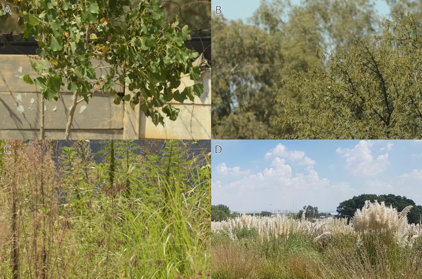
Biodiversity Baseline and Impact Assessment

Chloorkop Landfill Expansion

                                                Table of Contents
1   Introduction .................................................................................................................... 1

2   Project Area ................................................................................................................... 2

3   Scope of Work ............................................................................................................... 4

4   Limitations...................................................................................................................... 4

5   Methodologies ............................................................................................................... 4

          Geographic Information Systems Mapping ............................................................. 4

          Botanical Assessment ............................................................................................. 5

                 Literature Study ............................................................................................... 5

          Wet Season Fieldwork ............................................................................................ 6

          Faunal Assessment (Mammals & Avifauna) ............................................................ 6

          Herpetology (Reptiles & Amphibians) ..................................................................... 7

6   Key Legislative Requirements ........................................................................................ 7

7   Desktop Spatial Assessment.......................................................................................... 8

          General Land Use ................................................................................................... 9

          Gauteng Conservation Plan (Version 3.3) ............................................................... 9

          National Biodiversity Assessment ......................................................................... 11

                 Ecosystem Threat Status ............................................................................... 11

                 Ecosystem Protection Level ........................................................................... 12

8   Results & Discussion ................................................................................................... 13

          Desktop Assessment ............................................................................................ 13

                 Vegetation Assessment ................................................................................. 13

                 Vegetation Types ........................................................................................... 14

                 Egoli Granite Grassland ................................................................................. 14

                 Important Plant Taxa...................................................................................... 15

                 Faunal Assessment ....................................................................................... 17

9   Field Survey ................................................................................................................. 24

          Vegetation Assessment ........................................................................................ 24

                 Alien and Invasive Plants ............................................................................... 29

          Faunal Assessment .............................................................................................. 30

                                             www.thebiodiversitycompany.com

                                             info@thebiodiversitycompany.com

                                                                                                                                    iii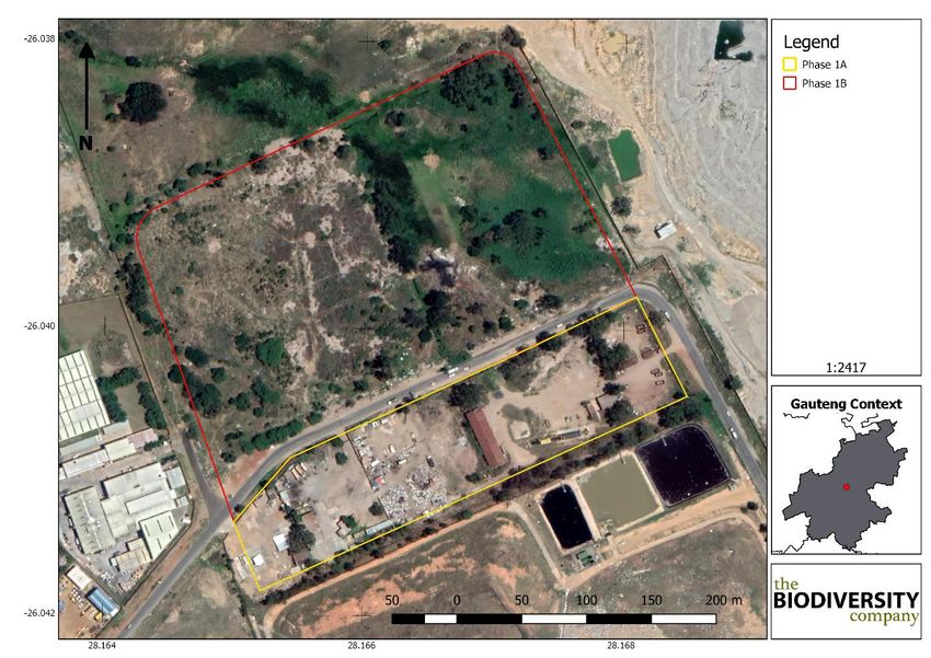
Biodiversity Baseline and Impact Assessment

Chloorkop Landfill Expansion

               Avifauna......................................................................................................... 30

               Mammals ....................................................................................................... 33

               Herpetofauna (Reptiles & Amphibians) .......................................................... 33

10    Habitat Sensitivity Mapping ...................................................................................... 33

11    Impact Assessment .................................................................................................. 36

         Impact Assessment Methodology ......................................................................... 36

         May 2019 Amendments ........................................................................................ 37

         Current Impacts .................................................................................................... 38

12    Impact Assessment Results ..................................................................................... 40

         Construction Phase (Phase 1B) ............................................................................ 40

         Operational Phase (Phase 1B).............................................................................. 41

         Closure Phase (Phase 1B).................................................................................... 41

         Assessment of Significance .................................................................................. 42

               Construction Phase (Phase 1B) ..................................................................... 42

               Operational Phase (Phase 1B) ...................................................................... 42

               Closure Phase (Phase 1B)............................................................................. 42

         Construction Phase (Phase 1A) ............................................................................ 49

         Operational Phase (Phase 1A).............................................................................. 49

         Closure Phase (Phase 1A).................................................................................... 49

         Assessment of Significance .................................................................................. 50

               Construction Phase (Phase 1A) ..................................................................... 50

               Operational Phase (Phase 1A) ...................................................................... 50

               Closure Phase (Phase 1A)............................................................................. 50

13    Mitigation Measures ................................................................................................. 55

         Objectives ............................................................................................................. 55

         Mitigation Measures .............................................................................................. 55

               Mitigation Measures for Impacts on Vegetation Communities ........................ 55

               Mitigation Measures for Impacts During the Operational Phase ..................... 56

               Mitigation Measures for Impacts During the Closure Phase ........................... 57

               Recommendations (Phase 1B and Phase 1A) ............................................... 57

                                           www.thebiodiversitycompany.com

                                           info@thebiodiversitycompany.com

                                                                                                                                 iv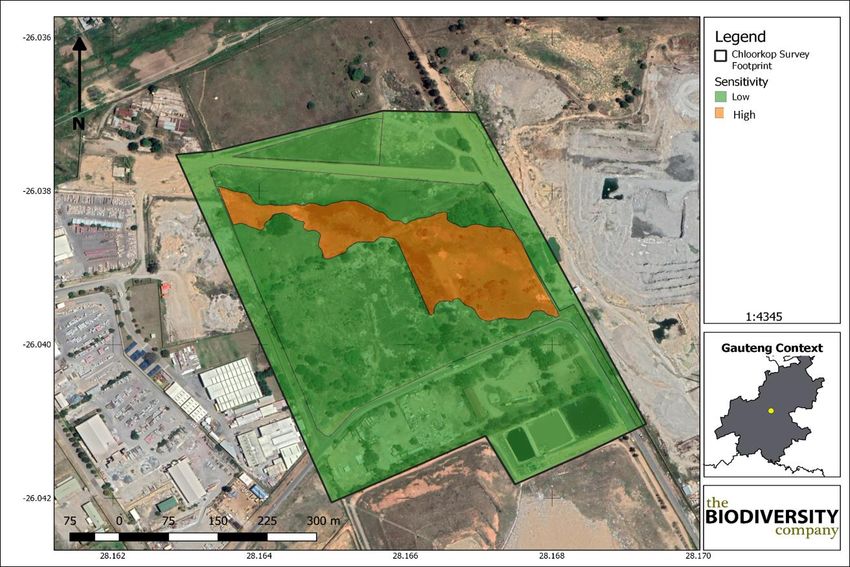
Biodiversity Baseline and Impact Assessment

Chloorkop Landfill Expansion

14        Conclusion ............................................................................................................... 57

15        Impact Statement ..................................................................................................... 59

16        References ............................................................................................................... 60

                                                                Tables
Table 1: A list of key legislative requirements relevant to biodiversity and conservation in
Gauteng ................................................................................................................................ 7

Table 2: Desktop spatial features examined.......................................................................... 8

Table 3: Plant SCC expected to occur in the project area (BODATSA-POSA, 2016). ......... 16

Table 4: List of bird species of regional or global conservation importance that are expected
to occur in pentads 2605_2810; 2605_2815; 2605_2805; 2600_2815; 2600_2805;
2555_2815; 2555_2810; 2555_2805; 2600_2810 (SABAP2, 2017, ESKOM, 2014; IUCN,
2017) .................................................................................................................................. 17

Table 5: List of mammal species of conservation concern that may occur in the project area
as well as their global and regional conservation statuses (IUCN, 2017; SANBI, 2016) ...... 21

Table 6: Herpetofauna SCC that may occur in the project area........................................... 24

Table 7: Trees, shrubs and weeds recorded at the proposed project area. ......................... 28

Table 8: A list of the avifaunal species recorded in the project area .................................... 31

Table 9: A list of herpetofauna recorded in the project area during the March 2019 survey . 33

Table 10: Assessment of significance of potential construction impacts on vegetation
communities associated with the proposed development pre- and post- mitigation ............. 44

Table 11: Assessment of significance of potential operational impacts on terrestrial
biodiversity associated with the proposed development pre- and post- mitigation ............... 45

Table 12: Assessment of significance of potential closure phase impacts on terrestrial
biodiversity associated with the proposed development pre- and post- mitigation ............... 47

Table 13: Assessment of significance of potential construction impacts on vegetation
communities associated with the proposed development (Phase 1A) pre- and post- mitigation
 ........................................................................................................................................... 51

Table 14: Assessment of significance of potential operational impacts on terrestrial
biodiversity associated with the proposed development (Phase 1A) pre- and post- mitigation
........................................................................................................................................... 52

Table 15: Assessment of significance of potential closure phase impacts on terrestrial
biodiversity associated with the proposed development (Phase 1A) pre- and post- mitigation
........................................................................................................................................... 54

                                                               Figures
                                                 www.thebiodiversitycompany.com

                                                 info@thebiodiversitycompany.com

                                                                                                                                             v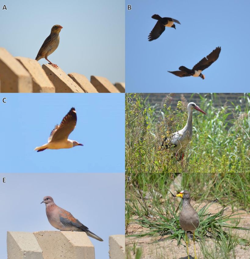
Biodiversity Baseline and Impact Assessment
Chloorkop Landfill Expansion
Figure 1: The general location of the project area ................................................................. 3
Figure 2: The project area superimposed on the Gauteng Conservation Plan (2014) ......... 10
Figure 3: Chloorkop project area showing the ecosystem threat status of the associated
terrestrial ecosystems (NBA, 2012) ..................................................................................... 12
Figure 4: Chloorkop project area showing the level of protection of terrestrial ecosystems
(NBA, 2012) ........................................................................................................................ 13
Figure 5: Project area showing the vegetation type based on the Vegetation Map of South
Africa, Lesotho & Swaziland (BGIS, 2017) .......................................................................... 14
Figure 6: Map showing the grid drawn in order to compile an expected species list (BODATSA-
POSA, 2016) ....................................................................................................................... 16
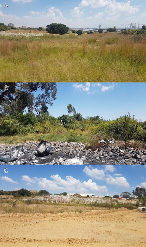
Figure 7: Habitats observed; A) Wetland, B) Degraded Grassland, C) Transformed ........... 26
Figure 8: The habitats delineated within the project area .................................................... 27
Figure 9: Some of the plant species observed in the project area: A) Populus alba, B) Vachellia
karroo, C) Verbena bonariensis and D) Cortaderia selloana ............................................... 29
Figure 10:Avifaunal species recorded during the survey: A) Southern Masked Weaver
(Ploceus velatus), B) Pied Crow (Corvus albus), C) Grey-head Gull (Crococephalus
cirrocephalus), D) White Stork (Ciconia ciconia), E) Laughing Dove (Streptopelia
senegalensis) and F) African Wattled Lapwing (Vanellus senegallus) ................................. 32
Figure 11: Bird flapper observed on the electrical wires in the project area ......................... 33
Figure 12: Habitat sensitivity within the project area ............................................................ 35
Figure 13: Image depicting the two proposed project phases (Phase 1A and Phase 1B (which
collectively includes Phase 1A) ........................................................................................... 38
Figure 14: Some of the impacts observed: A) Landfill, B) dumping of building rubble with large
trucks, C & D) Electrical wires, E) Fencing and F) Invasive plan species ............................ 39
Figure 15: Bird with broken wing, most likely due to an impact with the powerlines ............. 40
www.thebiodiversitycompany.com
info@thebiodiversitycompany.com
vi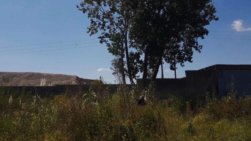
Biodiversity Baseline and Impact Assessment

Chloorkop Landfill Expansion

1 Introduction
The Biodiversity Company (TBC) was appointed by SLR Consulting to conduct a Baseline and
Impact Assessment on the terrestrial ecosystems associated with the proposed Chloorkop
Landfill Expansion.

EnviroServ own the Chloorkop Landfill Site (CLS) and operate it in terms of a waste
management license (Ref: 16/2/7/A230/D17/Z1). Municipal solid waste is received from the
Midrand area, including the City of Johannesburg and the Ekurhuleni Metropolitan Municipality.
The CLS is located in the Chloorkop Industrial area on Portion 63 of Klipfontein 12-IR and is
accessed from Marsala Road.

The CLS has been developed over the past two decades with six engineered waste disposal
cells that form the waste body. The waste body covers an area of approximately 23.2 ha. In
2016 GDARD granted approval for the permitted height of the waste body to be a maximum of
25 m above ground level.

Motivation for the expansion: The waste body at the CLS has finite airspace, defined by the
permitted footprint, height and design parameters. The CLS will not be able to receive waste
once it reaches airspace capacity.

Given the current and future waste generation potential of the Midrand region, there is an
ongoing need for waste disposal services, even with growing levels of waste diversion.
Alternative airspace in the Midrand region is limited. EnviroServ is proposing to expand the CLS
in order to provide additional airspace for ongoing disposal of municipal solid waste.

The proposal is to expand the Chloorkop Landfill Site onto adjacent properties. The targeted
properties, north of the site, are Erf 334 and 335 of Chloorkop Extension 6, which are
approximately 14 ha in extent. EnviroServ is in engagements with the property owner.

The concept is to establish engineered, Class B waste disposal cells on the target properties
for ongoing disposal of municipal solid waste. The additional waste disposal cells would join
with the current CLS waste body. The facility will include a small Material Recovery Facility for
the separation of clean recyclables from the waste. Supporting infrastructure would be
integrated with the CLS and/or redeveloped as appropriate.

Anker Street separates part of the extension area from the CLS and thus a phased approach is
likely. The first phase would entail the development and use of waste disposal cells between
the CLS and Anker Street. The second phase would involve the development and use of waste
disposal cells on the northerly portion of the site, connecting with the CLS and the first phase.
The second phase would only proceed if Anker Street had been relocated or closed (subject to
municipal engagement and approvals). The process to develop detailed designs for the waste
disposal cells has been initiated.

Support services: The primary support services and infrastructure associated with the proposed
expansion of the CLS include the site entrance and access controls, weigh bridge, leachate and
storm water management and landfill gas management. The process to develop detailed
designs for the supporting infrastructure has been initiated.

                                  www.thebiodiversitycompany.com

                                  info@thebiodiversitycompany.com

                                                                                               1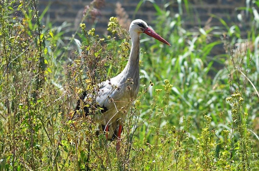
Biodiversity Baseline and Impact Assessment

Chloorkop Landfill Expansion

Access to the facility would be via Marsala Road, off the M38. Potable water and electricity
would be sourced from the Ekurhuleni Metropolitan Municipality via existing connections.
Effluent from the site will be disposed to the municipal sewage system.

A wet season terrestrial biodiversity survey was conducted on the 26th March 2019 by two
terrestrial ecologists. The survey was focused primarily on those areas which were most likely
to be impacted upon by the proposed development. Furthermore, the identification and
description of any sensitive receptors were recorded across the project area, and the manner
in which these sensitive receptors may be affected by the activity was also investigated.

This report, after taking into consideration the findings and recommendations provided by the
specialist herein, should inform and guide the Environmental Assessment Practitioner (EAP)
and regulatory authorities, enabling informed decision-making, as to the ecological viability of
the proposed development.

A distinct separation exists in the assessments of Phase 1A (located entirely on Erf 335) and
the assessment of Phase 1B (located on Erf 334), which cumulatively includes Phase 1A,
because it is a possibility that the applicant may elect to only apply for Phase 1A and could
discount Phase 1B as an alternative.

As a result, this specialist report has been compiled to provide impact assessments that
consider the project phasing as follows:

       1.    Phase 1A on Erf 335 (south of Anker Street which divides the property);

       2.    Phase 1A and 1B (entire footprint) cumulatively.

2 Project Area
The CLS is located in the Chloorkop Industrial area on Portion 63 of Klipfontein 12-IR and is
accessed from Marsala Road off the M38 in the Gauteng Province, South Africa. The land uses
surrounding the project area consists of the existing CLS to the south, the Klipfontein Sands
sand mine to the east and urban areas to the west and north. Some open areas of land exist to
the north of the project area, much of which exists underneath existing powerline servitudes.

                                 www.thebiodiversitycompany.com

                                 info@thebiodiversitycompany.com

                                                                                              2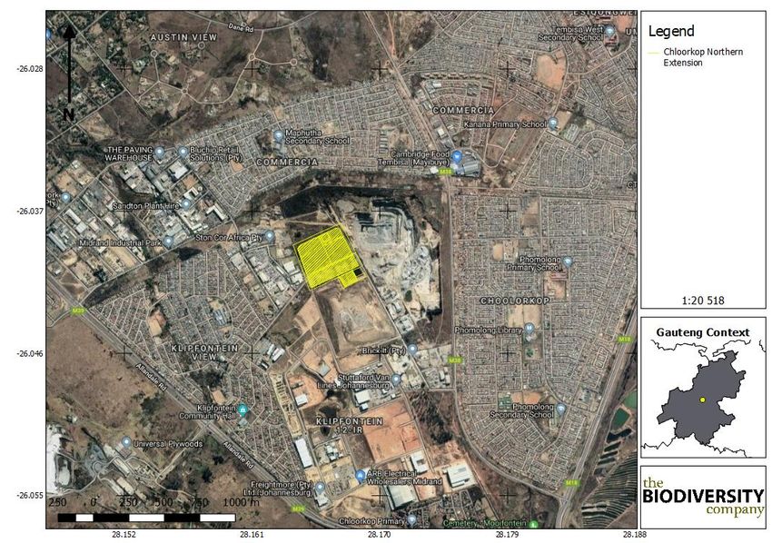
Biodiversity Baseline and Impact Assessment

Chloorkop Landfill Expansion

                                              Figure 1: The general location of the project area
                                                        www.thebiodiversitycompany.com

                                                                                                   3
Biodiversity Baseline and Impact Assessment
Chloorkop Landfill Expansion
3 Scope of Work
TBC was commissioned by SLR to conduct a baseline assessment for the proposed
development on Erf 334 and 335 of Chloorkop Extension 6, Gauteng, South Africa. The Terms
of Reference (ToR) included the following:
• Desktop description of the baseline receiving environment specific to the field of
expertise (general surrounding as well as site specific environment);
• Identification and description of any sensitive receptors in terms of relevant specialist
disciplines (biodiversity) that occur in the study area, and the manner in which these
sensitive receptors may be affected by the activity;
• Identify ‘significant’ ecological, botanical and zoological features within the proposed
development areas;
• Provide a map identifying sensitive receptors in the study area, based on available
maps, database information & site visit verification.
• Site visit to verify desktop information; and
• Screening to identify any critical issues (potential fatal flaws) that may result in project
delays or rejection of the application.
4 Limitations
The following limitations should be noted for the study:
• As per the scope of work, the fieldwork component of the assessment comprised one
assessment only, that was conducted during the wet season. This study has not
assessed any temporal trends for the respective seasons;
• The spatial data might not be accurate or based on outdated features; ground truthing
has been performed to try and increase the accuracy; and
• Despite these limitations, a comprehensive desktop study was conducted, in
conjunction with the detailed results from the surveys, and as such there is a high
confidence in the information provided.
5 Methodologies
Geographic Information Systems Mapping
Existing data layers were incorporated into a (Geographic Information Systems) GIS to
establish how the proposed development interacts with these important entities. Emphasis
was placed around the following spatial datasets:
• Vegetation Map of South Africa, Lesotho and Swaziland (Mucina et al., 2007);
• Important Bird Areas 2015 – BirdLife South Africa (vector geospatial dataset); and
• Gauteng Conservation Plan (Version 3.3).
www.thebiodiversitycompany.com
4Biodiversity Baseline and Impact Assessment
Chloorkop Landfill Expansion
• Field surveys were conducted to confirm (or refute) the presence of species identified
in the desktop assessment. The specialist disciplines completed for this study included:
• Botanical;
• Fauna (mammals and avifauna); and
• Herpetology (reptiles and amphibians).
Brief descriptions of the standardised methodologies applied in each of the specialist
disciplines are provided below. More detailed descriptions of survey methodologies are
available upon request.
Botanical Assessment
The botanical study encompassed an assessment of all the vegetation units and habitat types
within the project area. The focus was on an ecological habitat assessment of habitat types
as well as identification for any Red Data species within the known distribution of the project
area. The methodology included the following survey techniques:
• Timed meanders;
• Sensitivity analysis based on structural and species diversity; and
• Identification of floral Red Data species.
Literature Study
A literature review was conducted as part of the desktop study to identify the potential habitats
present within the project area. The SANBI provides an electronic database system, namely
the Botanical Database of Southern Africa (BODATSA), to access distribution records on
southern African plants. This is a new database which replaces the old Plants of Southern
Africa (POSA) database. The POSA database provided distribution data of flora at the quarter
degree square (QDS) resolution.
The Red List of South African Plants website (SANBI, 2016) was utilized to provide the most
current account of the national status of flora. Relevant field guides and texts consulted for
identification purposes in the field during the surveys included the following:
• Field Guide to the Wild Flowers of the Highveld (Van Wyk & Malan, 1997);
• A Field Guide to Wild flowers (Pooley, 1998);
• Guide to Grasses of Southern Africa (Van Oudtshoorn, 1999);
• Orchids of South Africa (Johnson & Bytebier, 2015);
• Guide to the Aloes of South Africa (Van Wyk & Smith, 2014);
• Medicinal Plants of South Africa (Van Wyk et al., 2013);
• Freshwater Life: A field guide to the plants and animals of southern Africa (Griffiths &
Day, 2016); and
www.thebiodiversitycompany.com
5Biodiversity Baseline and Impact Assessment
Chloorkop Landfill Expansion
• Identification Guide to Southern African Grasses. An identification manual with keys,
descriptions and distributions. (Fish et al., 2015).
Additional information regarding ecosystems, vegetation types, and species of conservation
concern (SCC) included the following sources:
• The Vegetation of South Africa, Lesotho and Swaziland (Mucina & Rutherford, 2012);
• Grassland Ecosystem Guidelines: landscape interpretation for planners and managers
(SANBI, 2013); and
• Red List of South African Plants (Raimondo et al., 2009; SANBI, 2019).
Wet Season Fieldwork
The wet season fieldwork and sample sites were placed within targeted areas (i.e. target sites)
perceived as ecologically sensitive based on the preliminary interpretation of satellite imagery
and GIS analysis (which included the latest applicable biodiversity datasets) available prior to
the fieldwork.
The focus of the fieldwork was to maximise coverage and navigate to each target site in the
field in order to perform a rapid vegetation and ecological habitat assessment at each sample
site. Emphasis was placed on sensitive habitats.
At each sample site notes were made regarding current impacts (e.g. pollution , invasive plant
species etc.), subjective recording of dominant vegetation species and any sensitive features
(e.g. wetlands, outcrops etc.). In addition, opportunistic observations were made while
navigating through the project area. Effort was made to cover all the different habitat types
within the limits of time and access.
Faunal Assessment (Mammals & Avifauna)
The faunal desktop assessment included the following:
• Compilation of identified species lists;
• Compilation of expected species lists;
• Identification of any Red Data or species of conservation concern (SCC) present or
potentially occurring in the area; and
• Emphasis was placed on the probability of occurrence of species of provincial, national
and international conservation importance.
The field survey component of the study utilised a variety of sampling techniques including,
but not limited to, the following:
• Visual observations;
• Identification of tracks and signs; and
• Utilization of local knowledge.
www.thebiodiversitycompany.com
6Biodiversity Baseline and Impact Assessment
Chloorkop Landfill Expansion
Herpetology (Reptiles & Amphibians)
A herpetofauna assessment of the project area was also conducted. The herpetological field
survey comprised the following techniques:
• Diurnal hand searches - are used for reptile species that shelter in or under particular
microhabitats (typically rocks, exfoliating rock outcrops, fallen timber, leaf litter, bark
etc.);
• Visual searches - typically undertaken for species whose behaviour involves surface
activity or for species that are difficult to detect by hand-searches or pitfall trapping.
May include walking transects or using binoculars to view species from a distance
without them being disturbed;
• Amphibians – many of the survey techniques listed above will be able to detect species
of amphibians. Over and above these techniques, vocalisation sampling techniques
are often the best to detect the presence of amphibians as each species has a distinct
call; and
• Opportunistic sampling - Reptiles, especially snakes, are incredibly illusive and difficult
to observe. Consequently, all possible opportunities to observe reptiles are taken, in
order to augment the standard sampling procedures described above. This will include
talking to local people and staff at the site and reviewing photographs of reptiles and
amphibians that the other biodiversity specialists may come across while on site.
6 Key Legislative Requirements
The legislation, policies and guidelines listed below are applicable to the current project in
terms of biodiversity and ecological support systems. The list below, although extensive, may
not be complete and other legislation, policies and guidelines may apply in addition to those
listed below.
Explanation of certain documents or organisations is provided (Table 1) where these have a
high degree of relevance to the project and/or are referred to in this assessment.
Table 1: A list of key legislative requirements relevant to biodiversity and conservation in
Gauteng
Convention on Biological Diversity (CBD, 1993)
INTERNATIONAL
The United Nations Framework Convention on Climate Change (UNFCC,1994)
The Convention on International Trade in Endangered Species of Wild Fauna and Flora (CITES
1973)
The Convention on the Conservation of Migratory Species of Wild Animals (Bonn Convention,
1979)
Constitution of the Republic of South Africa (Act No. 108 of 2006)
NATIONAL
The National Environmental Management Act (NEMA) (Act No. 107 of 1998)
The National Environmental Management Protected Areas Act (Act No. 57 of 2003)
The National Environmental Management Biodiversity Act (Act No. 10 of 2004)
www.thebiodiversitycompany.com
7Biodiversity Baseline and Impact Assessment
Chloorkop Landfill Expansion
The National Environmental Management: Waste Act, 2008 (Act 59 of 2008);
The Environment Conservation Act (Act No. 73 of 1989)
National Environmental Management Air Quality Act (No. 39 of 2004)
National Protected Areas Expansion Strategy (NPAES)
Natural Scientific Professions Act (Act No. 27 of 2003)
National Biodiversity Framework (NBF, 2009)
National Forest Act (Act No. 84 of 1998)
National Veld and Forest Fire Act (101 of 1998)
National Water Act, 1998 (Act 36 of 1998)
National Freshwater Ecosystem Priority Areas (NFEPA’s)
National Spatial Biodiversity Assessment (NSBA)
World Heritage Convention Act (Act No. 49 of 1999)
National Heritage Resources Act, 1999 (Act 25 of 1999)
Municipal Systems Act (Act No. 32 of 2000)
Alien and Invasive Species Regulations, 2014
South Africa’s National Biodiversity Strategy and Action Plan (NBSAP)
Conservation of Agricultural Resources Act, 1983 (Act 43 of 1983)
Sustainable Utilisation of Agricultural Resources (Draft Legislation).
White Paper on Biodiversity
GDARD Requirements for Biodiversity Assessments (Version 3, 2014a)
PROVINCIAL
Gauteng Department of Agriculture and Rural Development (GDARD): Checklist for Biodiversity
Assessments
GDARD Mining and Environmental Impact Guide
7 Desktop Spatial Assessment
The following features describes the general area and habitat, this assessment is based on
spatial data that are provided by various sources such as the provincial environmental
authority and SANBI. The desktop analysis and their relevance to this project are listed in
Table 2.
Table 2: Desktop spatial features examined
Desktop Information Considered Relevance Section
Land Use Relevant: description included 7.1
Conservation Plan Checked but falls outside of an ESA and CBA area 7.2
Not relevant, closes ridge is class 4 and its more than
Rocky Ridges -
3 km to the west of the project area
www.thebiodiversitycompany.com
8Biodiversity Baseline and Impact Assessment
Chloorkop Landfill Expansion
Ecosystem Threat Status Falls within an EN ecosystem 7.3.1
Ecosystem Protection Level Falls in a poorly protected ecosystem 7.3.2
Irrelevant: 35 km to the closes protected area: Cradle
Protected Areas -
of Human Kind.
No NFEPA wetlands or NFEPA rivers close to the
NFEPA Rivers and Wetlands -
project area.
Mining and Biodiversity Guidelines Irrelevant: no mining component -
Important Bird and Biodiversity Irrelevant: 35 km to the closest protected area:
-
Areas Cradle of Human Kind.
General Land Use
The land uses surrounding the project area consists of the existing CLS to the south, the
Klipfontein Sands sand mine to the east and urban areas to the west and north. Some open
areas of land exist to the north of the project area, much of which exists underneath existing
powerline servitudes.
The following infrastructure exists in the project area and surrounds:
• Various roads like Hatchet drive, Anker Street and Marsala Road;
• Power lines;
• Sand and Stone mine;
• Urban area with associated anthropogenic impacts; and
• Current landfill.
Gauteng Conservation Plan (Version 3.3)
The Gauteng Conservation Plan (Version 3.3) (GDARD, 2014b) (Gauteng C-Plan) classified
areas within the province on the basis of its contribution to reach the conservation targets
within the province. The Gauteng C-Plan uses the following terms to categorise the various
land used types according to their biodiversity and environmental importance:
• Critical Biodiversity Area (CBA);
• Ecological Support Area (ESA);
• Other Natural Area (ONA);
• Protected Area (PA); and
• Moderately or Heavily Modified Areas (MMA’s or HMA’s).
CBAs are terrestrial and aquatic areas of the landscape that need to be maintained in a natural
or near-natural state to ensure the continued existence and functioning of species and
ecosystems and the delivery of ecosystem services. CBAs are areas of high biodiversity value
and need to be kept in a natural state, with no further loss of habitat or species (GDARD,
2014b). Thus, if these areas are not maintained in a natural or near natural state then
www.thebiodiversitycompany.com
9Biodiversity Baseline and Impact Assessment
Chloorkop Landfill Expansion
biodiversity targets cannot be met. Maintaining an area in a natural state can include a variety
of biodiversity compatible land uses and resource uses (SANBI-BGIS, 2017).
ESAs are not essential for meeting biodiversity targets but play an important role in supporting
the ecological functioning of CBAs and/or in delivering ecosystem services. CBAs and ESAs
may be terrestrial or aquatic (SANBI-BGIS, 2017).
ONAs consist of all those areas in good or fair ecological condition that fall outside the
protected area network and have not been identified as CBAs or ESAs. A biodiversity sector
plan or bioregional plan must not specify the desired state/management objectives for ONAs
or provide land-use guidelines for ONAs (SANBI-BGIS, 2017).
Moderately or Heavily Modified Areas (sometimes called ‘transformed’ areas) are areas
that have been heavily modified by human activity so that they are by-and-large no longer
natural, and do not contribute to biodiversity targets. Some of these areas may still provide
limited biodiversity and ecological infrastructural functions but, their biodiversity value has
been significantly, and in many cases irreversibly, compromised.
As shown in Figure 2, the project area falls outside of any CBA and ESA areas.
Figure 2: The project area superimposed on the Gauteng Conservation Plan (2014)
www.thebiodiversitycompany.com
10Biodiversity Baseline and Impact Assessment
Chloorkop Landfill Expansion
National Biodiversity Assessment
The National Biodiversity Assessment (NBA) was completed as a collaboration between the
SANBI, the DEA and other stakeholders, including scientists and biodiversity management
experts throughout the country over a three-year period (Driver et al., 2011).
The purpose of the NBA is to assess the state of South Africa’s biodiversity with a view to
understanding trends over time and informing policy and decision-making across a range of
sectors (Driver et al., 2011).
The two headline indicators assessed in the NBA are ecosystem threat status and ecosystem
protection level (Driver et al., 2011).
Ecosystem Threat Status
Ecosystem threat status outlines the degree to which ecosystems are still intact or alternatively
losing vital aspects of their structure, function and composition, on which their ability to provide
ecosystem services ultimately depends (Driver et al., 2011).
Ecosystem types are categorised as Critically Endangered (CR), Endangered (EN),
Vulnerable (VU) or Least Threatened (LT), based on the proportion of each ecosystem type
that remains in good ecological condition (Driver et al., 2011).
The project area was superimposed on the terrestrial ecosystem threat status (Figure 3). As
seen in Figure 3 the project area falls entirely within an ecosystem which is listed as EN. The
NBA utilises a complex set of historic and current spatial datasheets to analyse the threat
status of particular ecosystems. Ecosystems can be classified as EN for example if they
provide habitat for SCC, threatened vegetation, and/or if only small portions of this ecosystem
are left and/or if they are not formally protected, such as in formally protected areas for
example. However, current land-uses often completely or partially alter these ecosystems.
The vegetation present in the project area is not representative of vegetation that represents
an EN ecosystem type. Only the wetland area in the central portion of the project area may
harbour fragments of habitat or vegetation that may represent remnants of an EN ecosystem
type.
www.thebiodiversitycompany.com
11Biodiversity Baseline and Impact Assessment
Chloorkop Landfill Expansion
Figure 3: Chloorkop project area showing the ecosystem threat status of the associated
terrestrial ecosystems (NBA, 2012)
Ecosystem Protection Level
Ecosystem protection level tells us whether ecosystems are adequately protected or under-
protected. Ecosystem types are categorised as not protected, poorly protected, moderately
protected or well protected, based on the proportion of each ecosystem type that occurs within
a protected area recognised in the Protected Areas Act (Driver et al., 2011).
The Chloorkop project area was superimposed on the ecosystem protection level map to
assess the protection status of terrestrial ecosystems associated with the development (Figure
4). Based on Figure 4 all of the terrestrial ecosystems associated with the development (entire
project area and surrounds) are rated as poorly protected.
www.thebiodiversitycompany.com
12Biodiversity Baseline and Impact Assessment
Chloorkop Landfill Expansion
Figure 4: Chloorkop project area showing the level of protection of terrestrial ecosystems
(NBA, 2012)
8 Results & Discussion
Desktop Assessment
Vegetation Assessment
The Chloorkop project area is situated within the grassland biome, specifically the Egoli
Granite Grassland. This biome is centrally located in southern Africa, and adjoins all except
the desert, fynbos and succulent Karoo biomes (Mucina & Rutherford, 2006). Major
macroclimatic traits that characterise the grassland biome include:
a) Seasonal precipitation; and
b) The minimum temperatures in winter (Mucina & Rutherford, 2006).
The grassland biome is found chiefly on the high central plateau of South Africa, and the inland
areas of KwaZulu-Natal and the Eastern Cape. The topography is mainly flat and rolling but
includes the escarpment itself. Altitude varies from near sea level to 2 850 m above sea level.
Grasslands are dominated by a single layer of grasses. The amount of cover depends on
rainfall and the degree of grazing. The grassland biome experiences summer rainfall and dry
winters with frost (and fire), which are unfavourable for tree growth. Thus, trees are typically
www.thebiodiversitycompany.com
13Biodiversity Baseline and Impact Assessment
Chloorkop Landfill Expansion
absent, except in a few localized habitats. Geophytes (bulbs) are often abundant. Frosts, fire
and grazing maintain the grass dominance and prevent the establishment of trees.
Vegetation Types
The grassland biome comprises many different vegetation types. The project area is situated
entirely in one vegetation type; the Egoli Granite Grassland (Gh 10), according to Mucina &
Rutherford (2006) (Figure 5).
Figure 5: Project area showing the vegetation type based on the Vegetation Map of South
Africa, Lesotho & Swaziland (BGIS, 2017)
Egoli Granite Grassland
Egoli Granite Grassland occurs only in the Gauteng province, and less than 32% of this
vegetation type remains untransformed. The province has a target to conserve and protect
25% of the remaining vegetation type.
Egoli Granite Grassland is characterised by a high species richness with a patchy dominance
of various grass species, and a large variety of forbs (broad leafed herbaceous plant, other
than grass), representing a climax or close to climax condition.
www.thebiodiversitycompany.com
14Biodiversity Baseline and Impact Assessment
Chloorkop Landfill Expansion
Important Plant Taxa
Important plant taxa are those species that have a high abundance, a frequent occurrence or
are prominent in the landscape within a particular vegetation type (Mucina & Rutherford,
2006).
The following species are important in the Egoli Granite Grassland vegetation type:
Graminoids: Aristida canescens, A. congesta, Cynodon dactylon, Digitaria monodactyla,
Eragrostis capensis, E. chloromelas, E. curvula, E. racemosa, Heteropogon contortus,
Hyparrhenia hirta, Melinis repens subsp. repens, Monocymbium ceresiiforme, Setaria
sphacelata, Themeda triandra, Tristachya leucothrix, Andropogon eucomus, Aristida
aequiglumis, A. diffusa, A. scabrivalvis subsp. borumensis, Bewsia biflora, Brachiaria serrata,
Bulbostylis burchellii, Cymbopogon caesius, Digitaria tricholaenoides, Diheteropogon
amplectens, Eragrostis gummiflua, E. sclerantha, Panicum natalense, Schizachyrium
sanguineum, Setaria nigrirostris, Tristachya rehmannii, Urelytrum agropyroides.
Herbs: Acalypha angustata, A. peduncularis, Becium obovatum, Berkheya insignis, Crabbea
hirsuta, Cyanotis speciosa, Dicoma anomala, Helichrysum rugulosum, Justicia anagalloides,
Kohautia amatymbica, Nidorella hottentotica, Pentanisia prunelloides subsp. latifolia,
Pseudognaphalium luteo-album and Senecio venosus.
Geophytic Herbs: Cheilanthes deltoidea, C. hirta.
Low Shrubs: Anthospermum hispidulum, A. rigidum subsp. pumilum, Gnidia capitata,
Helichrysum kraussii, Ziziphus zeyheriana.
Tall Shrub: Searsia pyroides.
Succulent Shrub: Lopholaena coriifolia.
8.1.4.1 Conservation Status of the Vegetation Type
According to Mucina & Rutherford (2006), this vegetation type is classified as EN. The national
target for conservation protection for both these vegetation types is 24%, but only 3% is
conserved in statutory (Diepsloot and Melville Koppies Nature Reserves). More than two thirds
of this vegetation unit have already undergone transformation mostly due to urbanisation,
cultivation or by building of roads.
8.1.4.2 Plant Species of Conservation Concern
Based on the Plants of Southern Africa (BODATSA-POSA, 2016) database, 101 plant species
are expected to occur in the area (Figure 5). The list of expected plant species is provided in
Appendix A. Of the 101-plant species, two (2) species are listed as being SCC (Table 3).
www.thebiodiversitycompany.com
15Biodiversity Baseline and Impact Assessment
Chloorkop Landfill Expansion
Site Location
Figure 6: Map showing the grid drawn in order to compile an expected species list
(BODATSA-POSA, 2016)
Table 3: Plant SCC expected to occur in the project area (BODATSA-POSA, 2016).
Family Taxon Author IUCN Ecology
(G.Will.)
Orchidaceae Habenaria mossii EN Indigenous; Endemic
J.C.Manning
Aizoaceae Lithops lesliei subsp. lesliei (N.E.Br.) N.E.Br. NT Indigenous
Habenaria mossii is listed as EN according to the Red List of South African
Plants (SANBI, 2017) and can be found in the Carletonville Dolomite
Grassland, Andesite Mountain Bushveld and is found in open grassland on
dolomite or in black, sandy soil. Threats are mainly urban expansion (Pfab et
al., 2005).
Lithops lesliei subsp. lesliei is listed as near threatened according to the Red
List of South African Plants (SANBI, 2017). This species occurs primarily in
arid grasslands, usually in rocky places, growing under the protection of forbs
and grasses. This species is threatened by habitat destruction and is used in
the muthi trade.
www.thebiodiversitycompany.com
16Biodiversity Baseline and Impact Assessment
Chloorkop Landfill Expansion
Faunal Assessment
8.1.5.1 Avifauna
Based on the South African Bird Atlas Project, Version 2 (SABAP2) database, 344 bird species
are expected to occur in the vicinity of the project area (pentads 2605_2810; 2605_2815;
2605_2805; 2600_2815; 2600_2805; 2555_2815; 2555_2810; 2555_2805; 2600_2810). The
full list of potential bird species is provided in Appendix B.
Of the expected bird species, twenty (20) species (5.81%) are listed as SCC either on a
regional (19) or global scale (9) (Table 4).
The SCC include the following:
• One (1) species that is listed as CR on a regional basis; and
• Three (3) species that are listed as EN on a regional basis; and
• Five (5) species that are listed as VU on a regional basis; and
• Ten (10) species that are listed as NT on a regional basis.
Table 4: List of bird species of regional or global conservation importance that are expected
to occur in pentads 2605_2810; 2605_2815; 2605_2805; 2600_2815; 2600_2805;
2555_2815; 2555_2810; 2555_2805; 2600_2810 (SABAP2, 2017, ESKOM, 2014; IUCN,
2017)
Conservation Status
Likelihood of
Species Common Name Regional
IUCN (2017) Occurrence
(SANBI, 2016)
Alcedo semitorquata Kingfisher, Half-collared NT LC Low
Anthropoides paradiseus Crane, Blue NT VU Low
Aquila verreauxii Eagle, Verreaux's VU LC Low
Calidris ferruginea Sandpiper, Curlew LC NT Low
Ciconia abdimii Stork, Abdim's NT LC Low
Circus ranivorus Marsh-harrier, African EN LC Low
Coracias garrulus Roller, European NT LC Low
Falco biarmicus Falcon, Lanner VU LC Low
Falco vespertinus Falcon, Red-footed NT NT Low
Glareola nordmanni Pratincole, Black-winged NT NT Low
Gyps africanus Vulture, White-backed CR CR Low
Gyps coprotheres Vulture, Cape EN EN Low
Mycteria ibis Stork, Yellow-billed EN LC Low
Oxyura maccoa Duck, Maccoa NT NT Low
Phoenicopterus minor Flamingo, Lesser NT NT Low
Phoenicopterus ruber Flamingo, Greater NT LC Low
Rostratula benghalensis Painted-snipe, Greater NT LC Low
Sagittarius serpentarius Secretarybird VU VU Low
Sterna caspia Tern, Caspian VU LC Low
Tyto capensis Grass-owl, African VU LC Low
www.thebiodiversitycompany.com
17Biodiversity Baseline and Impact Assessment
Chloorkop Landfill Expansion
Alcedo semitorquata (Half-collared Kingfisher) is listed as NT on a regional scale and occurs
across a large range. This species generally prefers narrow rivers, streams, and estuaries with
dense vegetation onshore, but it may also move into coastal lagoons and lakes. It mainly feeds
on fish (IUCN, 2017). Due to the lack of suitable water sources in the project area the likelihood
of occurrence is rated as low.
Anthropoides paradiseus (Blue Crane) is listed as NT on a regional scale and as VU on a
global scale. This species has declined, largely owing to direct poisoning, power-line collisions
and loss of its grassland breeding habitat owing to afforestation, mining, agriculture and
development (IUCN, 2017). This species breeds in natural grass- and sedge-dominated
habitats, preferring secluded grasslands at high elevations where the vegetation is thick and
short. Due to the lack of suitable habitat and the chance of persecution the chance of likelihood
is rated as low.
Aquila verreauxii (Verreaux’s Eagle) is listed as VU on a regional scale and LC on a global
scale. This species is locally persecuted in southern Africa where it coincides with livestock
farms, but because the species does not take carrion, is little threatened by poisoned
carcasses. Where hyraxes are hunted for food and skins, eagle populations have declined
(IUCN, 2017). Based on the state of the environment and the absence of prey species the
likelihood of occurrence is rate as low.
Calidris ferruginea (Curlew Sandpiper) is migratory species which breeds on slightly elevated
areas in the lowlands of the high Arctic and may be seen in parts of South Africa during winter.
During winter, the species occurs at the coast, but also inland on the muddy edges of marshes,
large rivers and lakes (both saline and freshwater), irrigated land, flooded areas, dams and
saltpans (IUCN, 2017). Due to the absence of suitable habitat type the likelihood of occurrence
is rated as low.
Ciconia abdimii (Abdim's Stork) is listed as NT on a local scale and the species is known to
be found in open grassland and savanna woodland often near water but also in semi-arid
areas, gathering beside pools and water-holes. They tend to roost in trees or cliffs (IUCN,
2017). The existence of wet areas creates the potential for this species to occur in the area
but due to the proximity of the urban footprint, the high human density and the degraded state
of the environment the likelihood of occurrence was rated as low.
Circus ranivorus (African Marsh Harrier) is listed as EN in South Africa (ESKOM, 2014). This
species has an extremely large distributional range in sub-equatorial Africa. South African
populations of this species are declining due to the degradation of wetland habitats, loss of
habitat through over-grazing and human disturbance and possibly, poisoning owing to over-
use of pesticides (IUCN, 2017). This species breeds in wetlands and forages primarily over
reeds and lake margins. There are no suitable habitats in the project area and as such the
likelihood of occurrence is rated as low.
Coracias garrulous (European Roller) is a winter migrant from most of South-central Europe
and Asia occurring throughout sub-Saharan Africa (IUCN, 2017). The European Roller has a
preference for bushy plains and dry savannah areas (IUCN, 2017). There is a low chance of
occurrence because of the anthropogenic disturbances in the area.
www.thebiodiversitycompany.com
18Biodiversity Baseline and Impact Assessment
Chloorkop Landfill Expansion
Falco biarmicus (Lanner Falcon) is native to South Africa and inhabits a wide variety of
habitats, from lowland deserts to forested mountains (IUCN, 2017). They may occur in groups
up to 20 individuals but have also been observed solitary. Their diet is mainly composed of
small birds such as pigeons and francolins. The likelihood of incidental records of this species
in the project area is rated as low, even though prey species are present it is unlikely that the
species will be present due to the disturbed nature of the area.
Falco chicquera (Red-necked Falcon) is classed as NT on a global scale. This species was
recently split from its Indian counterpart Falco chicquera. The African species is mostly found
in semi-dessert and savanna areas with some trees for perching. The number of this species
is declining due to ongoing habitat degradation. The likelihood of occurrence in the project
area is rated as low due to the absence of suitable habitat.
Glareola nordmanni (Black-winged Pratincole) is a migratory species which is listed as NT
both globally and regionally. This species has a very large range, breeding mostly in Europe
and Russia, before migrating to southern Africa. Overall population declines of approximately
20% for this species are suspected (IUCN, 2017). This species generally occurs near water
and damp meadows, or marshes overgrown with dense grass. Due to its migratory nature,
this species will only be present in South Africa for a few months during the year and will not
breed locally. There is no suitable habitat found in the project area and as such the likelihood
of occurrence is rated as low.
Gyps africanus (White-backed Vulture) has a large range and only occurs throughout sub-
Saharan Africa. Primarily a lowland species of open wooded savanna, particularly areas of
Acacia (Vachellia). It requires tall trees for nesting. According to the IUCN (2017) this species
faces similar threats to other African vultures, being susceptible to habitat conversion to agro-
pastoral systems, loss of wild ungulates leading to a reduced availability of carrion, hunting for
trade, persecution and poisoning. Even though there might be suitable food sources at the
landfill because of the high level of human presence the likelihood of occurrence is rated as
low.
Gyps coprotheres (Cape Vulture) is listed as EN on both a regional and global scale. Cape
Vultures are long-lived carrion-feeders specialising on large carcasses, they fly long distances
over open country, although they are usually found near steep terrain, where they breed and
roost on cliffs (IUCN, 2017). It is unlikely for this species to occur in the area because of the
disturbed nature of the area.
Mycteria ibis (Yellow-billed Stork) is listed as EN on a regional scale and LC on a global scale.
This species is migratory and has a large distributional range which includes much of sub-
Saharan Africa. It is typically associated with freshwater ecosystems, especially wetlands and
the margins of lakes and dams (IUCN, 2017). With no suitable waterbodies present in the
project area the likelihood of occurrence is rated as low.
Oxyura maccoa (Maccoa Duck) has a large northern and southern range, South Africa is part
of its southern distribution. During the species’ breeding season, it inhabits small temporary
and permanent inland freshwater lakes, preferring those that are shallow and nutrient-rich with
extensive emergent vegetation such as reeds (Phragmites spp.) and cattails (Typha spp.) on
which it relies for nesting (IUCN, 2017). The likelihood of occurrence of this species in the
project area was rated as low, as no suitable habitat is present.
www.thebiodiversitycompany.com
19You can also read