CITY OF LYNDEN COMPREHENSIVE STORMWATER MANAGEMENT PLAN - NOVEMBER 2019
←
→
Page content transcription
If your browser does not render page correctly, please read the page content below
CITY OF LYNDEN
COMPREHENSIVE STORMWATER
           MANAGEMENT PLAN

                         NOVEMBER 2019

REICHHARDT & EBE ENGINEERING, INC. AND WELCH ECOLOGICAL SERVICES, LLC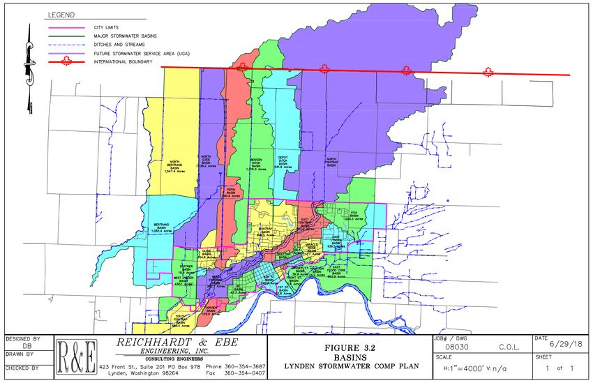
City of Lynden Draft Comprehensive Stormwater Management Plan

                CITY OF LYNDEN
        COMPREHENSIVE STORMWATER
            MANAGEMENT PLAN

November 2019

                                        Welch Ecological
                                             Services, LLC

    2
City of Lynden Draft Comprehensive Stormwater Management Plan

Contents
1.0 Introduction ............................................................................................................................................ 5
2.0 Federal and State Regulations Pertaining to Stormwater ...................................................................... 5
   2.1 NPDES Phase II .................................................................................................................................... 5
   2.2 Total Maximum Daily Load Studies (TMDLs) ...................................................................................... 6
   2.3 Endangered Species Act (ESA) ............................................................................................................ 6
   2.4 Puget Sound Plan ................................................................................................................................ 7
   2.5 City of Lynden Regulations.................................................................................................................. 7
3.0 Study Area Physical Description.............................................................................................................. 7
   3.1 Vicinity................................................................................................................................................. 7
   3.2 Drainage Basins ................................................................................................................................... 9
   3.3 Climate .............................................................................................................................................. 11
   3.4 Soils ................................................................................................................................................... 11
4.0 Stormwater Service Area ...................................................................................................................... 13
5.0 Stormwater Program Development...................................................................................................... 13
   5.1 NPDES Phase II Permit - Overview of Required Elements ................................................................ 13
   5.2 Lynden Municipal Code and Standards Revisions............................................................................. 16
   5.3 Local Coordination ............................................................................................................................ 17
6.0 General Stormwater Issues ................................................................................................................... 17
   6.1 Existing Drainage System Overview .................................................................................................. 17
   6.2 Operation, Maintenance and Ownership of Stormwater Facilities – Public and Private ................. 17
   6.3 System Design Considerations and Retrofits .................................................................................... 18
       6.3.1 Adjacent and Adjoining Jurisdictions ......................................................................................... 18
       6.3.2 Retrofits...................................................................................................................................... 18
   6.4 Low Impact Development Practices ................................................................................................. 19
   6.5 Groundwater Determination ............................................................................................................ 19
   6.6 Fish Exclusion .................................................................................................................................... 20
7.0 Stormwater Systems Analysis and Capital Improvement Plan ............................................................. 20
   7.1 Introduction ...................................................................................................................................... 20
   7.2 Capital Improvement Projects .......................................................................................................... 21

            3
City of Lynden Draft Comprehensive Stormwater Management Plan

       7.2.1 SWO1 – B.C. Avenue .................................................................................................................. 24
       7.2.2 SWO2 – Cedar Drive ................................................................................................................... 27
       7.2.3 SWO3/SWO4 – Historic Business District Treatment and South Historic Business District
       Tributary Conveyance ......................................................................................................................... 29
       7.2.4 SWO5 – East Lynden Annexation ............................................................................................... 30
       7.2.5 SWO6 - Lynden Industrial Stormwater Retrofit ......................................................................... 31
       7.2.6 SWO7 – Pepin Creek Phase 1 ..................................................................................................... 31
       7.2.7 SWO8 – West Lynden Regional Facility...................................................................................... 32
       7.2.8 SWO9 - Woodcreek Neighborhood. .......................................................................................... 33
       7.2.9 SW010 – Low Impact Development from 7th to 10th Street and from Front to Judson Street 36
       7.2.10 SW011 – South Park & Parkview Drive .................................................................................... 37
       7.2.12 SWO12 – Groundwater Monitoring ......................................................................................... 37
       7.2.13 SW013 – Decant Facility at City Maintenance Shop ................................................................ 37
       7.2.13a SW013a – Material Storage at City Maintenance Shop ......................................................... 37
       7.2.13b SW013b – Vehicle Washing at City Maintenance Shop ......................................................... 37
       7.2.13c SW013c – Upgrade Storm Discharge at City Maintenance Shop Upgrade existing south
       storm water discharge along southern access.................................................................................... 37
       7.2.13d SW013d- Runoff Treatment for City Shop North Parking Lot ................................................ 37
8.0 Storm Water Utility Section .................................................................................................................. 38
9.0 References Cited ................................................................................................................................... 38
Appendix A: Stormwater Capital Improvement Plan Exhibits .................................................................... 40

            4
City of Lynden Draft Comprehensive Stormwater Management Plan
1.0 Introduction
The Comprehensive Stormwater Management Plan for the City of Lynden (City) offers guidance on ways
to minimize the adverse effects of stormwater runoff to receiving water bodies and identifies existing
stormwater issues within the system. The Plan provides City staff and policy makers with the
background and necessary information to develop and manage the storm drainage system in a cost-
effective manner that complies with regulatory stipulations. The objectives are to understand the
current conveyance and water quality treatment issues in order to position the City for effective
planning of future improvements. As such, this plan functions as a long-term planning tool that will
ready the City for the anticipated growth in population over a 20-year horizon. The Plan outlines
methods for meeting regulatory requirements and developing policies, procedures, and defines capital
facilities projects for the Stormwater Utility.
This plan is organized from general to specific. First, the regulatory framework is discussed in Section
2.0. Sections 3.0 to 6.0 are meant to provide background and general setting for the physical
characteristics of the Lynden vicinity, the Stormwater Service Area, and the existing storm system.
Section 7.0 discusses storm system analysis, and Capital Improvement Projects. Section 8.0 details the
administration of the Stormwater Utility.
2.0 Federal and State Regulations Pertaining to Stormwater
There are many federal, state, and local regulations relevant to the management of stormwater within
the City of Lynden’s jurisdiction. The responsibility for implementing many of the federal regulations is
delegated to the State. The following paragraphs discuss the most pertinent regulations.
2.1 NPDES Phase II
In 2013, the City of Lynden (City) was designated by the Environmental Protection Agency and the
Washington State Department of Ecology as one of thousands of municipalities in the United States
requiring a special stormwater permit. The Western Washington Phase II Municipal Stormwater Permit
(Permit) was issued under the National Pollutant Discharge Elimination System (NPDES) to achieve the
goals of the federal Clean Water Act. The Phase II Permit was deemed necessary because stormwater
runoff from streets, parking lots, construction sites, industrial properties, and residential areas is now
recognized as one of the leading sources of pollution to our streams, lakes, wetlands, the Nooksack
River and Puget Sound.
The Phase II Permit allows municipalities to discharge stormwater from municipal systems into “waters
of the state” such as rivers, lakes and streams, as long as there are programs in place to reduce
pollutants in stormwater to the “maximum extent practicable”. Much of the stormwater runoff from
the City of Lynden’s municipal separate storm sewer system (MS4) discharges into Fishtrap Creek, a
tributary to the Nooksack River that runs through the middle of the City. Smaller volumes of stormwater
5City of Lynden Draft Comprehensive Stormwater Management Plan
go to Kamm Creek, Duffner Ditch, and Bertrand Creek (other Nooksack Tributaries), and some
stormwater goes directly into the Nooksack River. Eventually, all of the stormwater from the Lynden
MS4 goes into the Nooksack River and ultimately Puget Sound. Regulating stormwater quality is also a
designated component of the City’s Comprehensive Plan. Section 5.0 of this plan discusses the
development of the City’s Stormwater Management Program to meet the terms and conditions of the
NPDES Phase II Permit.
2.2 Total Maximum Daily Load Studies (TMDLs)
In the late 1990’s, Ecology undertook a Nooksack River Watershed Bacteria TMDL evaluation (Joy, 2000)
and completed an associated Detailed Implementation Plan in 2002 (Hood, 2002). A TMDL analysis
determines a plan of action to bring water bodies back into compliance with water quality standards and
often requires more stringent standards than the current water quality standards (WDOE, 2006). The
Nooksack River TMDL coverage includes areas served by MS4s draining to the Nooksack River which
includes the City of Lynden. Fishtrap Creek was found to be one of several tributaries that contributed
elevated fecal coliform loads to the lower Nooksack River and is listed (303d) as impaired for fecal
coliform (Joy, 2000).
The Phase II permit requires that all jurisdictions subject to an approved TMDL undertake additional
requirements as outlined in Appendix 2 of the Western Washington Phase II Municipal Stormwater
Permit. Appendix 2 of the permit specifically requires the City of Lynden to select a priority basin from
which to collect and analyze fecal coliform samples. To meet this requirement the City currently
monitors fecal coliform levels at an outfall on BC Avenue on a monthly basis and after several storm
events. In addition, the City is required to annually submit an update to the Stormwater Capital
Improvement Plan which is contained in Section 7.0 of this report.
2.3 Endangered Species Act (ESA)
The federal Endangered Species Act was promulgated to provide a program that will conserve the
ecosystems of endangered and threatened species. This is accomplished through many means one of
which is Habitat Conservation Plans (HCPs). HCPs outline how the endangered species habitat will be
managed to minimize impacts. The ESA listings are maintained by the U.S. Fish and Wildlife Service
(USFW) and the National Oceanic and Atmospheric Administration (NOAA).
Stormwater can impact salmon habitat by increasing quantity of runoff and transporting pollutants.
Evaluation of stormwater impacts as a part of the stormwater management program will address
impacts on critical fish habitat in the receiving waters.
According to WDFW SalmonScape, streams within the City of Lynden support the following salmonids.
Fishtrap Creek supports fall chinook, coho, fall chum, winter steelhead, bulltrout (presumed), and
cutthroat. Double Ditch Creek supports fall chinook, coho, fall chum (modelled presence), winter
steelhead, bulltrout (presumed), and cutthroat. Stickney Slough supports fall chinook. Bertrand Creek
supports coho, fall chum, winter steelhead, sockeye (unusual), and bulltrout (presumed). Puget Sound
Chinook, Puget Sound Steelhead, and bulltrout are listed under the Endangered Species Act.
6City of Lynden Draft Comprehensive Stormwater Management Plan
2.4 Puget Sound Plan
The Puget Sound Partnership was established by the State Legislature in 2007 to develop an action
agenda and plan to clean up, restore, and protect Puget Sound. The Partnership developed the Puget
Sound Plan to meet this charge.
The Puget Sound Plan, a conservation and recovery plan, identifies stormwater as one of the leading
problems contributing to the decline in the health of Puget Sound. Many of the required conditions of
the NPDES Permit were adopted to meet the action items identified in the Puget Sound Plan including
use of Low Impact Development (LID) techniques and educating the public and businesses on good
housekeeping practices that will help reduce the sources of pollutants in stormwater.
The City of Lynden is developing a stormwater program to address strategic initiatives and near term
actions as itemized in Section 5.0.
2.5 City of Lynden Regulations
The City’s Comprehensive Plan, Growth Management Act polices (e.g. Urban Growth Areas, Critical
Areas Ordinance and Shoreline Management Plan), as well as the Development Standards also detail the
importance of managing stormwater runoff for both quantity and quality.
3.0 Study Area Physical Description
3.1 Vicinity
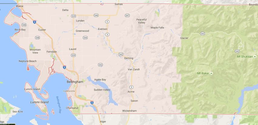
The City of Lynden is located in west central Whatcom County, the most northerly county in western
Washington State that is adjacent to Puget Sound (Figure 3.1). The northern line of Whatcom County
borders the Canadian province of British Columbia. The City of Lynden has a population of 13,326
according to the 2016 estimate (Shoreline Master Plan). At the time of this study, the area within the
City was approximately 3,378 acres. Future revisions to the City limits are anticipated through
annexation of the defined Urban Growth Areas.
7City of Lynden Draft Comprehensive Stormwater Management Plan
Figure 3.1 Vicinity Map
The primary waterway within the City of Lynden is Fishtrap Creek, a tributary to the Nooksack River. The
Fishtrap Creek watershed area encompasses approximately 39.4 mi2 or 25,190 acres. The upper half of
the watershed lies in Canada where headwater tributaries begin in two marshes. Topographically, the
basin is a nearly flat plain sloping gently south. The flat area encompasses most of the Lynden terrace
where intensive farming occurs north of the City. Elevations vary from 25 feet near the confluence to
475 feet in Canada. In general, the southern areas of the City of Lynden are characterized as low lying
plain areas, with mild slopes ranging in elevation from 50 to 60 feet above mean sea level. The majority
of the City itself and surrounding areas are characterized with flat rolling topography ranging in
elevation from 60 to 115 feet above mean sea level. Within the City limits approximately 1,530 acres
drain to Fishtrap Creek, 1,030 acres drain to Lynden’s East flood Plain, and approximately 475 acres
drain to Duffner Ditch, 110 Acres drain to Bertrand Creek, and 175 Acres drain to Lynden’s western flood
plains.
The predominant land use in the U.S. portion of the Fishtrap Creek watershed is agricultural. A number of
parallel ditches along the roadways form the major tributary system. As Pepin Creek crosses the
International Border, it is relegated to two drainage ditches along Double Ditch Road which come back
together at Main Street in Lynden. Ditches also run along Benson Road. North of the City limits, these
drainage ditches were developed to improve farming by lowering the high water table. Within the City,
land use is characterized by a mixture of single family residential, multi-family residential, commercial
establishments, pockets of industrial areas, a small airport, schools, churches, and public parks. There is
a small amount of agricultural land remaining in the City limits and the City houses the Northwest
Washington Fairgrounds. The City of Lynden, typical of small towns, has a portion of its land area as
impervious surfaces. These impervious surfaces include roads, parking areas, houses, other buildings, and
driveways.
8City of Lynden Draft Comprehensive Stormwater Management Plan
3.2 Drainage Basins
The City of Lynden and surrounding areas were delineated into major drainage basins and subbasins.
The basins were defined by area, topography, location of drainage courses, and existing storm drainage
facilities using the following data:
• Whatcom County’s critical areas map, with basin delineation
• City of Lynden Storm Drainage Inventory Map
• 2002 Walker and Associates, Inc Aerial Topography (2 foot contours)
• As well as previous drainage work within the City performed by Reichhardt & Ebe
Common receiving bodies of water within the City are roadside ditches, creeks, streams, wetlands,
ponds, lakes, and the Nooksack River. Major basins define contributing areas that concentrate all
overland storm water to a single conveyance point. Tributary basins to the north and to the west of
Lynden influence water elevations in various ditches, and creeks, and streams within the City. Figure 3.2
maps the contributing drainage basins in and surrounding Lynden. The following table provides a list of
the City of Lynden major storm water basins in alphabetical order.
Table 3.1 – Defined Major Basins
Area
Basin Name
(Acres)
1st Street 22.8
6th Street 198.0
BC 47.7
Benson Ditch 1,316.0
Bertrand 1,082.4
Depot Ditch 931.9
Drayton 48.4
Duffner 18.9
East Fishtrap 387.2
East Flood Zone 663.9
East Lynden 439.5
Fairview 125.6
Fishtrap 606.5
Front Street 7.6
Grover Street 39.9
Guide 154.6
Hampton 24.2
KOA 500.3
Miracle Ridge 117.7
North Bertrand 1,547.4
North Fishtrap 6,399.5
North Guide 1,138.2
Pepin 980.6
South Fishtrap 586.4
West Fishtrap 362.7
West Lynden 430.1
Study Area Totals: 18,178.0
9City of Lynden Draft Comprehensive Stormwater Management Plan 10
City of Lynden Draft Comprehensive Stormwater Management Plan

3.3 Climate
The Lynden climate is fairly mild. The temperature ranges from winter lows of around 32o F to typical
summer highs of 76 o F. The average annual precipitation is 46 inches as measured at Clearbrook, WA,
and the average snowfall is approximately 14 inches per year.

3.4 Soils
Soil surveys contain information that effect land use and planning within the survey areas. Soil surveys
highlight each soil’s limitations which and can be a useful tool for several different professions and
community members. One of the ways Engineers utilize soil surveys is to look at a soil’s hydrologic
rating to estimate stormwater runoff. The United States Department of Agriculture (USDA) NRCS Web
Soils Survey data (USDA, 2016) was used to define the hydrologic soils group information for this study.

Runoff generated by a storm event is directly related to the soil properties present. Hydrologic soil
groups are based on estimates of runoff potential. Soils are assigned to one of four groups according to
the rate of water infiltration when the soils are not protected by vegetation, are thoroughly wet, and
receive precipitation from long duration storms. Soils in the City of Lynden can be categorized in four
major hydrologic groups, Type A, Type B, Type C, and Type D.

Type A soils are categorized as having a high infiltration rate and low runoff potential. Type D soils are
typically clay-like and have a very slow infiltration rate resulting in relatively large amounts of
stormwater runoff. Lynden is primarily made up of Type B and C soils which have moderate runoff and
infiltration characteristics. Figure 3.3 provides the approximation percentages of hydrologic soil types
within the City of Lynden. This chart shows that the City of Lynden, as a whole, has medium to slow
infiltration rates with moderate runoff potential.

The hydrologic soil group is a generalization of the runoff potential of the surficial soils. It is not
necessarily a direct correlation to the site suitability for the application of infiltration as a mitigation
measure for stormwater. Often times, infiltration facilities are placed below the surficial soils, the soils
which are more related to the generation of runoff. The soils below, may often be courser, more
permeable, and therefore more conducive to infiltration.

       11
City of Lynden Draft Comprehensive Stormwater Management Plan
1.6%
16.5%
44.3%
37.6%
Hydrologic Type A: 1.6% Hydrologic Type B: 44.3%
Hydrologic Type C: 37.6% Hydrologic Type D: 16.5%
Figure 3.3- City of Lynden Hydrologic Soil Makeup
The USDA recognizes several distinct soils within the City of Lynden. Soil types and areas were
approximated and quantified and can be found below in Table 3.2. The Appendix contains additional
properties and qualities information for each individual soil. It should be noted that soil maps and soil
properties go through periodic updates, therefore it is suggested owners review and utilize current soil
information for future developments.
Table 3.2 – Soil Types within the City of Lynden
USDA Hydrologic Percent
Unit Name Approximate Slope
number Type Land Cover
Briscot silt loam, 0 to 2 percent
22 D 1.5 %
drained
Edmonds-Woodlyn
45 0 to 2 percent D 12.4 %
loams
Hale silt loam,
62 0 to 2 percent C 14.3 %
drained
79 Kickerville silt loam 0 to 3 percent B 3.8 %
80 Kickerville silt loam 3 to 8 percent B 5.8 %
Laxton loam
96 0 to 3 percent C 13.7 %
99 Lynden sandy loam 0 to 3 percent B 7.1 %
100 Lynden sandy loam 3 to 8 percent B 6.3 %
Lynden-Urban land
101 0 to 3 percent B 21.2 %
complex
Lynnwood sandy
103 5 to 20 percent A 1.6 %
loam
Pangborn muck
116 0 to 2 percent D 2.4 %
12City of Lynden Draft Comprehensive Stormwater Management Plan
Puyallup fine sandy
124 0 to 2 percent B 0.1 %
loam
Shalcar muck
143 0 to 2 percent D 0.1 %
151 Snohomish silt loam 0 to 2 percent D 0.1 %
Tromp loam
165 0 to 2 percent C 9.6 %
Water
193 n/a n/a 0.1 %
Total 100%
4.0 Stormwater Service Area
The City of Lynden currently provides stormwater service for the public stormwater system within the
City limits and proposes to extend public stormwater service to Urban Growth Areas as they are
annexed into the City limits.
There are several developments which are not connected to the City’s stormwater system. They are
privately owned and discharge directly to receiving water bodies. The City has the ability to access and
inspect privately owned stormwater management systems within the City limits. Additionally, the City
has the appropriate amount of authority to enforce maintenance on the privately owns systems within
the City’s jurisdiction.
5.0 Stormwater Program Development
5.1 NPDES Phase II Permit - Overview of Required Elements
The City of Lynden (City) has developed a Stormwater Management Program (SWMP) to meet the terms
and conditions of its Western Washington Phase II Municipal Stormwater Permit (Permit). The first
Permit issued by the Department of Ecology (Ecology) became effective August, 1 2013, ran through July
31, 2018 and was extended one year. In August 2019, Ecology issued a new permit cycle with additional
requirements which is effective until July 31, 2024 The City is required to continue to build the program
over the term of the permit and file an annual report and supplemental attachments by March 31st each
year of the Permit term. The most recent annual report is posted on the City’s website
(http://www.lyndenwa.org/public-works/stormwater/) and details the permit compliance
accomplishments carried out during the previous calendar year and activities planned for the coming
year.
NPDES Phase II Permit program elements are listed below with permit section in parentheses.
Stormwater Management Program Development (S5.A & S5.B)
13City of Lynden Draft Comprehensive Stormwater Management Plan
Public Education and Outreach Component (S5.C.1)
Public Involvement and Participation Component (S5.C.2)
Illicit Discharge Detection and Elimination (S5.C.3 & G3)
Controlling Runoff from New Development, Redevelopment and Construction Sites (S5.C.4)
Pollution Prevention and Operation and Maintenance for Municipal Operations (S5.C.5)
Appendix 2 Total Maximum Daily Load Requirements (S7)
Monitoring (S8) –not required for Lynden during this permit term
Since 2013, the City has been following the Permit timeline for developing its stormwater program. The
costs of administering this program has and will vary by permit element as the program evolves over the
permit term. Estimated 2019 costs by program element can be found in Figure 5.1. The first few years
of the permit term were focused on building both the education and outreach element and public
involvement element. During 2015 and 2016, efforts on the previously initiated program elements were
continued and increased. In addition, focus was expanded to include illicit discharge detection and
elimination. The Lynden Municipal Code was revised to include targeted Illicit Discharge language and
adopted December 21st, 2015. Follow-up water quality monitoring was conducted and storm system
samples taken to bracket areas of high fecal coliform counts. Pollutant source identification will
continue to be investigated and source control measures implemented where feasible as part of this
program.
14City of Lynden Draft Comprehensive Stormwater Management Plan
Table 5.1 Stormwater Management Program Elements
Interlocal
Stormwater Management Estimated
Agreement with Estimated Potential Funding
Program Element (S5 & S7 City Staff Status Element Task Notes
Conservation Consulting Source
Permit Components) Costs *
District * Costs *
Annually • Develop and mail stormwater brochures to residents
• Target different audiences & document behavioral changes
S5. A & C.1 Education and Implementing
Local Utility Funds • Provide outreach & stewardship opportunities/ water quality sampling
General Stormwater Program $6,000 $30,000 $22,000 NPDES Permit
State: Ecology • Coordinate and partner with Whatcom County and Whatcom Conservation
Development Requirements on District
Schedule • Hold stormwater committee meetings
• Stay current with recordkeeping and reporting to Ecology
Annually Local Utility Funds • Present stormwater items to Planning commission, Public Works committee
Implementing State: Ecology and council
S5.C.2 Public Involvement $2,500 $10,000 $8,000 NPDES Permit • Present at external stakeholders meetings and public hearings
Requirements on • Maintain website with current stormwater information
Schedule
Annually Local Utility Funds • Complete Outfall inventory / Field screening
S5.C.3 Illicit Discharge Implementing State: Ecology • Post spill/ water quality hotline number on website
Detection and Elimination $3,000 ---- $18,000 NPDES Permit • Update storm drain map
Program Requirements on • Conduct water quality monitoring and source control investigations
Schedule • Complete video inspection of suspect storm drain lines
• Train staff on identifying and characterizing illicit discharges
Annually Local Utility Funds • Revise municipal code and engineering standards for runoff control
S5.C.4 Runoff Control from
Implementing State: Ecology integrating low impact development techniques
New Development, • Outline stormwater permitting process, site plan review, construction
$6,000 ---- NPDES Permit
Redevelopment and $40,000 inspections & long term maintenance plans for facilities
Requirements on
Construction Sites • Train staff on permitting, inspection and maintenance standards and new
Schedule
implementation pamphlets and application forms
Annually Local Utility Funds
• Develop municipal O&M protocols to reduce pollutants e.g. inspecting and
Implementing State: Ecology
S5.C.5 Municipal Operations vactoring catchbasins, street sweeping frequency, road repair etc.
$24,000 ---- NPDES Permit
and Maintenance Program • Complete pollution prevention & spill response plans for shops
$12,500 Requirements on • Annually inspect- post 2013public and private stormwater facilities
Schedule • Train staff on good housekeeping procedures
S7 Total Maximum Daily Load Annually submitted Local Utility Funds
$3,000 ---- $ 200 • Continue monitoring BC Avenue outfall and report annually to Ecology on
Permit Requirements on Schedule State: Ecology fecal coliform trends
S7 Stormwater Capital Annually submitted Local Utility Funds
$12,000 ---- $6,200 • Update the stormwater capital improvement plan and report annually to
Improvement Plan on Schedule State: Ecology Ecology
Total costs and element subtotals will vary year to year depending on permit emphasis and the timeline of specific requirements
15City of Lynden Draft Comprehensive Stormwater Management Plan
In 2016, the City also began focusing on the process of revising the Municipal Code titles involving
controlling runoff from new development, redevelopment and construction sites. The City of Lynden,
adopted the most current edition of the Department of Ecology Stormwater Management Manual for
Western Washington (SWMMWW) (WDOE, 2012) as part of the code revisions in 2017. These code
revisions were in place before December 31, 2017 and required low impact development (LID)
techniques as the preferred alternative to conventional stormwater management best management
practices. The permit requires the City to take measures to minimize impervious surfaces, minimize loss
of natural vegetation, and employ other measures to minimize stormwater runoff entering the system.
The City conducted an internal review of pertinent documents to include LID language. The
comprehensive plan LID language suggestions were submitted; development standards, permitting,
building inspections, and design review protocol were updated. Through the site plan review process
the City reviews development and redevelopment plans to ascertain compliance with the City’s
Development Standards. Internal City review of documents and code occurs
In 2016, the City of Lynden deemed that there was a public benefit to converting existing residential
septic systems to the public sanitary sewer system to help the City meet the goals of its water quality
program and compliance with the Phase II NPDES stormwater permit.
A septic to sewer program was established due to this concern of potential pollution from failing on-site
septic systems (OSS). This program provides property owners within the City limits that have existing
septic systems the incentive to connect to the City sewer system by waiving the payment of general
facility charges.
Since the program began in 2016, 35 septic systems have been converted and another 14 are expected
in 2019. This program has cost to date $367,760 in lost revenue to the City sewer fund. The expected
conversions for 2019 will waive fees of another $149,473.
Growth of the stormwater program in 2017 and 2018 included carrying out specific requirements of the
pollution prevention and operation and maintenance for Municipal Operations element. Protocol on
good housekeeping practices were developed, stormwater pollution prevention plans were completed
for the City maintenance shops, and training of City Staff continues for all permit elements.
The City continues to fulfill its requirements to monitor fecal coliform levels at one outfall from its MS4
(BC Avenue) and annually update its Stormwater Capital Improvement Plan (Section 7.0 of this
document) to meet the Appendix 2 TMDL stipulations.
5.2 Lynden Municipal Code and Standards Revisions
The City of Lynden has undertaken efforts to ensure backing and enforcement of the stormwater
program through code and standards revisions. As mentioned previously, the City revised the Lynden
Municipal Code (LMC) and Design and Development Standards (to comply with the requirements of the
NPDES Permit and Ecology’s SWMMWW to meet the LID integration requirements. Continued review of
code and standards will be conducted.
16City of Lynden Draft Comprehensive Stormwater Management Plan
5.3 Local Coordination
The City of Lynden has been coordinating with other jurisdictions and entities regarding stormwater
management. In 2014, the City entered into an interlocal agreement with Whatcom Conservation
District to perform water quality sampling along Fishtrap Creek and conduct and track stormwater
education and outreach on behalf of the City. The City coordinates with both Whatcom County and
Whatcom Conservation District regarding water quality sampling along Fishtrap Creek as part of the
Whatcom County Enhanced Pollution Identification and Correction Program. Collaboration with
Whatcom County, North Lynden Watershed Improvement District, Bertrand Watershed Improvement
District, Whatcom Clean Water Program and Whatcom Conservation District will continue to ensure that
the City of Lynden is well represented and the most up-to-date outreach materials and methods are
being employed. The City will also continue to partner with Whatcom County Department of Public
Health for local pollution source control visits to businesses in Lynden. These visits include onsite
inspection and technical assistance on appropriate good housekeeping practices. Education and
outreach will be ongoing as part of the County Health Department’s Septic program. The City will also
be developing its own pollution source program to meet the permit terms.
6.0 General Stormwater Issues
6.1 Existing Drainage System Overview
The City currently maintains the stormwater conveyance systems, either ditched or piped and 2 regional
detention or treatment facilities. The MS4 system has several dozen outfalls to Fishtrap Creek, a few to
the Nooksack directly, outfalls to Kamm Creek on the east side of town, and outfalls to Duffner Ditch
and Bertrand Creek from the stormwater regional facility on the west side of town.
The City has utilized regional stormwater facilities to provide stormwater mitigation for future
developments. These regional facilities often provide benefit to property owners where there is limited
space and a more watershed based approach to mitigating peak runoff.
An inventory of existing public and private stormwater drainage system attributes has been compiled
from field inspection data and as-built maps. Detail from this inventory has been transferred to the
City’s Geographical Information System database and storm system map folio’s are available to the
Public Works Engineering Staff and City Crews.
6.2 Operation, Maintenance and Ownership of Stormwater Facilities – Public and
Private
The public stormwater system in the City of Lynden is operated solely by the City of Lynden. The day-to-
day operation is conducted by the City of Lynden Public Works Department. In 2015 the City of Lynden
instituted a stormwater utility fee structure to provide specific monies for the operation of the
stormwater system. This stormwater utility fee is required to provide a consistent funding source for
regular operation and maintenance of the storm system. Section 8.0 discusses the stormwater utility in
more depth.
17City of Lynden Draft Comprehensive Stormwater Management Plan
The City is responsible for storm facilities within the City right-of-way or within drainage easements in
favor of the City including; stormwater pipes, ditches, streams, detention facilities, water quality
treatment facilities, control structures, and pumping facilities. The only exception to the above is lot
storm stubs, also called private storm side services. These lot services typically encroach onto public
lands to make connection to City stormwater mains. These individual lot service pipes are typically
small, 4” to 6” in diameter. The City has consistently defined these services/stubs as privately
maintained up to the point of connection to the City main. The NPDES Phase II permit however,
requires that the City inspect all private and public stormwater facilities on an annual basis and perform
or require the performance of maintenance as necessary.
6.3 System Design Considerations and Retrofits
6.3.1 Adjacent and Adjoining Jurisdictions
Coordination with adjacent and adjoining jurisdictions is paramount for the City because planned or
potential capital improvements to their stormwater infrastructure could impact City operations. If
neighboring agencies modify their existing facilities, they may directly or indirectly affect the City. If
infrastructure upstream of the City that has historically attenuated flows entering the City is upsized
through improvement, the City’s system will receive greater peak flows. Conversely, downstream
systems that are similarly undersized may preclude the City from allowing appropriate discharge from its
jurisdiction. For these reasons, the City should remain aware of how other agencies’ existing and
proposed improvements may affect the City’s infrastructure. In particular, coordination should continue
with Washington State Department of Transportation for the Guide Meridian and Badger Road
infrastructure and Whatcom County for the Badger Road and upstream systems.
For example, there is anecdotal information which points to the fact that the culvert and bridge
crossings under the Badger Road are undersized. During large events, it is apparent that runoff backs up
within the ditches north of Badger Road (SR-546). The majority of these drainage basins are located in
British Columbia, Canada as seen in Figure 3.2. Sometimes this water reaches a stage which allows the
water to flow south over the roadways located at the border and even Badger Road itself. In the recent
years (2009, 2005), various roadways in this area have been closed due to water over the road resulting
in safety and mobility issues. Water flows over the roadway, particularly over the state routes
exacerbate transportation issues within the City limits. Recent winter storm events and their aftermath
have seen runoff water from one overcapacity system cross into another already taxed system. The lack
of system capacity attenuates the flow from unincorporated Whatcom County into the City limits until it
flows over the road.
6.3.2 Retrofits
In addressing the reduction of pollutants entering the City’s storm system, the City recognizes the
importance of encouraging retrofitting existing stormwater systems in order to improve water quality
especially in re-development situations. The City is pursuing grant funding to undertake several
identified Capital Improvement Projects that involve retrofitting existing facilities (detailed in Section
7.0).
18City of Lynden Draft Comprehensive Stormwater Management Plan
6.4 Low Impact Development Practices
One of the requirements under the NPDES Phase II permit is for local governments to adopt ordinances
that low impact development (LID) practices as the preferred approach prior to conventional methods.
LID practices infiltrate stormwater (using proper safeguards to protect groundwater) on-site rather than
collecting, conveying and discharging stormwater off site. The goals of low impact development
practices are to enhance overall habitat functions, reduce runoff, recharge aquifers, maintain historic in-
stream flows and reduce maintenance costs. Low impact development practices may not be appropriate
or feasible for all sites. Low impact principles include:
Maintain the pre-developed, undisturbed stormwater flows and water quality;
Retain native vegetation and soils to intercept, evaporate and transpire stormwater on the site
(rather than using traditional ponds and conveyances);
Emphasize a higher standard of soil quality in disturbed soils (by using compost and other
methods) to improve infiltration, reduce runoff and protect water quality;
Cluster development and roads on the site and retain natural features that promote infiltration;
and
Reduce impervious surface area and use permeable surfaces instead.
6.5 Groundwater Determination
Infiltration as a stormwater mitigation method is preferred by both the regulating agencies and often
the developer. The SWMMWW lists infiltration as the preferred method for a number of reasons, the
greatest of which is that it continues to allow recharge of the soil strata and allows the watershed to act
more naturally than other methods. Developers often prefer infiltration as a mitigation measure due to
the fact that it is often constructed below grade and is not an aesthetic nuisance. Furthermore, the fact
that it can be constructed below grade allows utilization of that portion of the parcel for other purposes
such as parking, sidewalks, or open space. The City is promoting LID techniques as the preferred option.
Multiple design factors can preclude infiltration as a suitable mitigation measure. One of the greatest is
the elevation of the seasonal high groundwater elevation (SHGW). According to the SWMMWW it is
preferred to have 5-feet of separation from the SHGW to the bottom of the infiltration facility. This
separation may be reduced to 3-feet if a positive result is found through a Groundwater Mounding
Analysis and a Volume Receptor Analysis. If LID techniques are utilized, then groundwater separation
can be reduced even further. A second site suitability criterion is the infiltration rate of the soil. As
discussed previously in Section 3.4, Soils, infiltration facilities are often constructed below grade and the
subsurface soils would need to be assessed for infiltration suitability.
Fortunately, much of the area within the existing City limits has soil which is conducive to infiltration.
However, an important remaining question is whether the SHGW elevation would allow sufficient
separation to use infiltration. To truly determine the SHGW, elevation observations need to be made
during the wet season. If a developer chooses to proceed with the design of a project in May, they will
most likely need to wait until October or November to determine the SHGW, and to comply with the
guidance provided in the SWMMWW. This delay, sometimes, presents a significant impediment to
development. To help facilitate development in these areas, the City could consider taking advance
19City of Lynden Draft Comprehensive Stormwater Management Plan
actions to try to determine the SHGW for use by City staff in communicating with developers and to
confirm their design assertions. Determination of the SHGW elevation can be accomplished through the
installation of piezometers within the City right-of-ways or other City properties in the vicinity of future
planned developable areas. These piezometers could be monitored regularly by staff or level
transducers could be installed and read on an annual basis.
With the increased emphasis on infiltration at the site scale, it can be expected that over time
stormwater pollutants will reach the groundwater. The City will also need to consider protection of
groundwater during the review process of LID feasibility, especially as the number of infiltration facilities
increase.
6.6 Fish Exclusion
The City of Lynden has numerous conveyance systems, whether ditch or piped, which discharge to fish
bearing streams. The City should consider constructing facilities which exclude fish from entering newly
constructed conveyance facilities, unless they have been explicitly designed for that purpose.
Conveyance facilities such as these are subject to intermittent flow, and can inadvertently strand fish.
There are numerous methods to construct fish passage barriers which are applicable to different
situations and there are multiple steps which must first be taken. The City will require that WDFW
approve the locations which should be excluded and the method used for exclusion.
7.0 Stormwater Systems Analysis and Capital Improvement Plan
7.1 Introduction
City staff has identified many stormwater systems of areas of interest/concern within their existing and
proposed service boundary. These interests range from, addressing policy issues to finding solutions to
areas with documented drainage issues. Capital improvement projects which address capacity and
water quality concerns where feasible were identified and further analysis of various locations to more
fully identify if improvements might be needed in the future. This section will address these issues.
Water quality is an important aspect of stormwater management. Beyond being good stewards of the
resource, the City is required through the NPDES Permit to follow specific protocol in an effort to comply
with the federal Clean Water Act (see Section 2.0 of this document). For this reason, all projects will at a
minimum comply with City Standards which adopt Ecology’s Stormwater Management Manual for
Western Washington (SWMM). See section 6.3 of this document for discussions in regards to retrofit
projects.
Many of the issues which will be discussed deal with the capacity of conveyance systems. Therefore, it
is pertinent to discuss the standard of practice for the design of conveyance systems. All conveyance
systems are intended to pass a specified amount of flow. Flow is determined based on return
frequency, this is the probability that the storm will occur. A 100-year return frequency storm has a
probability of occurrence of once every 100 years. It is important to point out that the return frequency
20City of Lynden Draft Comprehensive Stormwater Management Plan
is the probability that the amount of rainfall will be equaled or exceeded once on the average. This
means that, for example, a 100-year event could occur two years in a row.
The following table (7.1) shows the rainfall intensities utilized for the City of Lynden Stormwater
Management Plan. The 24-hour rainfall intensities for different storm events were determined from the
NOAA Atlas 2 (Precipitation-Frequency Atlas of the Western United States, Volume IX – Washington,
1973).
Table 7.1 - Rainfall Intensities Used
Storm Event Inches in 24 hours
6 Month 1.37
2 Year 1.90
10 Year 2.80
25 Year 3.25
100 Year 4.00
Stormwater models conducted for this plan were based on a Type 1A rainfall distribution for the 24-
hour storm event per industry standards. Standard of practice in Western Washington is that the
conveyance system must have the capacity to convey the 25-year return frequency storm within the
facility, and demonstrate that the 100-year return frequency storm will not cause adverse impacts to
adjacent and downstream properties. This approach is used in both the WSDOT Highway Runoff Manual
and City’s Engineering Design and Development Standards. Typically, this means that stormwater must
be contained within street curbs and flow to a downstream system of sufficient capacity, during the
100-year event.
Whatcom County and the Lynden vicinity have a history of flooding events precipitated by heavy rainfall
occurring on frozen ground (which acts as an impervious surface) covered by an amount of snowfall.
These events are not considered standard of practice for design. This flooding is not simply a function
of the conveyance geometry, which can be compromised as a result of those systems being clogged with
snow, sheets of ice blocking culverts and any number of mechanical failures caused by an act of nature.
City, County and WSDOT resources can be over-extended during such inclement events, minimizing the
responsiveness to what might not be easily perceived as a problem during the early stages of an event.
7.2 Capital Improvement Projects
The City, in its effort to maintain infrastructure, is considering certain stormwater projects for
construction. A summary of those Capital Improvement Projects and their anticipated costs and status
can be found in the Table 7.2 on the following page. These projects are at varying stages of
development, and are listed in no particular order. Additional detail for each of the listed projects in
Table 7.2 can be found in the remaining sections of this chapter and in the exhibits included in Appendix
A. Appendix A starts with the overall site plan exhibit which shows the location of all the Capital
Improvement Projects, then is followed by exhibits for each project.
21City of Lynden Draft Comprehensive Stormwater Management Plan
Table 7.2: CIP Projects
Estimated Estimated
Potential Funding
Proj # Project Title Construction Consulting Status Status Notes Timeline Timeline Notes
Source
Costs Costs
Local Funds Pipe sizing approximated, Design and Within 20 To be combined with other Public Works projects to reduce
SWO-1 BC Avenue $580,000 $185,000 30% Design
State: Ecology Construction funds required years impacts to adjacent properties.
Local Funds Within 10 To be combined with other Public Works projects to reduce
SWO-2 Cedar Drive $145,000 $50,000 5% Design Design and Construction funds required.
State: Ecology years impacts to adjacent properties. Design budgeted for 2018.
Basic treatment facility Constructed,
Historic Business District Tributary Local Funds To be combined with other Public Works projects to reduce
SWO-3 $565,000 $190,000 50% Design South Historic Business District Conveyance Within 5 years
Conveyance State: Ecology impacts to adjacent properties.
and/or mitigation required.
Historic Business District 100% Local Funds
SWO-4 $900,000 $90,000 Facility has been constructed. Complete Project Completed.
Treatment Facility Constructed State: Ecology
Line Road Improvements: Burlwood to
SWO-4a $800,000 $200,000 90% Design Local Funds Design in final phases Complete To be constructed 2017. Project Completed.
Aaron Drive
Line Road Culvert Designed, Additional
design required for basin drainage. Waiting
To be combined with other Public Works projects to reduce
Local Funds for Construction Funds.
SWO-5 East Lynden Annex $650,000 $175,000 50% Design Within 5 years impacts to adjacent properties.
State: Ecology Private development in this area is being
Waiting for Funding
designed and constructed to current
Ecology standards.
To be combined with other Public Works projects. To be
Local Funds Within 20
SWO-6 Lynden Industrial Retrofit $1,600,000 $400,000 60% Design Design and Construction funds required. considered if water quality improvements are required or
State: Ecology years
funding is provided.
30% Design
Pepin Creek Phase I, Upstream of Main Local Funds Design and Construction funds required. Within 10 Upon annexation into the City limits and as required by
SWO-7 $8,202,000 $1,730,000 100% property
Street State: Ecology Initial planning must be complete. years Development.
acquired
Pepin Creek Phase II, Downstream of Local Funds Design and Construction funds required.
SWO-7b 10% Design Within 5 years Detailed design will identify access requirements.
Main Street State: Ecology Preliminary Design must be complete.
20% Design
Local Funds Construction funds required. Design must
SWO-7c Pepin Creek Phase III, Main Street Bridge 100% property Within 2 years
State: Ecology be complete.
acquired
Local Funds Phase I constructed, Phase 2 awaiting Within 10
SWO-8 West Lynden Regional Facility $1,000,000 $300,000 30% Design As required by Developer interest.
State: Ecology design and construction funds. years
Local Funds Within 10 To be combined with other Public Works projects to reduce
SWO-9 Woodcreek Neighborhood $540,000 $180,000 10% Design Design and Construction funds required.
State: Ecology years impacts to adjacent properties.
Planning and Studies to be complete when funding is
DOE funded Design and Construction funds required.
SWO-10 LID 7th to 10th Street/Front to Judson $ TBD $120,000 State: Ecology Within 5 years available. Selected for funding in 2017, Capital Budget has
design project. Initial planning must be complete
not been approved.
100% Design,
Waiting for Construction to be complete when funding is available.
SWO-11 South Park & Parkview Drive $365,000 $160,000 Local Funds Construction and CM funds required. Complete
Construction Began final design in 2017. To be constructed 2018.
Funds
22City of Lynden Draft Comprehensive Stormwater Management Plan
Design and Construction funds required.
SWO-12 Groundwater Monitoring $60,000 $5,000 Local Funds Within 5 years Construction to be complete when funding is available.
Initial planning must be complete
SWO-13 Decant Facility at City Maintenance Shop Within 10
$1,000,000 $250,000 Ecology funded Local, Ecology Result of SWPPP development Scheduled for 2020 Construction
years
Material Storage at City Maintenance
SWO-13a $250,000 Within 10
Shop $30,000 Planning Only Local, Ecology Result of SWPPP development Construction to be complete when funding is available.
years
Vehicle Wash Facility at City
SWO-13b Within 10
Maintenance Shop $75,000 $10,000 Planning Only Local, Ecology Result of SWPPP development Construction to be complete when funding is available.
years
Upgrade Storm Discharge at City
SWO-13c Within 10
Maintenance Shop $350,000 $45,000 Planning Only Local, Ecology Result of SWPPP development Construction to be complete when funding is available.
years
Runoff Treatment for City Shop North
SWO-13d Within 10
Parking Lot $250,000 $30,000 Planning Only Local, Ecology Result of SWPPP development Construction to be complete when funding is available.
years
23City of Lynden Draft Comprehensive Stormwater Management Plan
7.2.1 SWO1 – B.C. Avenue
A large portion of Lynden’s central residential neighborhoods utilizes an outfall along B.C. Avenue. The
City has been proactively upgrading stormwater facilities as roadway improvement projects occur in this
area. Generally, stormwater conveyance capacity should be increased along C Street and B.C. Avenue.
In addition the City is monitoring the water quality of the outfall and will consider the results in the
design of this project. Refer to Appendix A.1 for additional details regarding B.C. Avenue analysis and
improvements.
The outfall on B.C. Avenue serves approximately 40 city blocks of runoff from the older residential area
of Lynden, see exhibit in Appendix showing drainage area. In some areas of the City, old infrastructure
is difficult to inspect, because a portion of the existing storm main cannot be accessed. It is assumed
that when these old areas redevelop, a new storm system and water quality improvements may be
installed. An existing condition model was constructed based on the available records and engineering
judgment, the model should only be used as a general guideline; drainage areas and patterns should be
verified prior to the replacement of a stormwater trunk main within this basin. The model approximates
the runoff from each basin so future projects may include an upgraded conveyance system. A more
accurate model of the existing pipe network can be produced when the unknown pipe elevations, sizes,
material, condition, and slopes have been discovered.
The City has recently performed work in the upper portions of this basin. The work involved the
replacement of old pipes. The lower portion of this system may be nearing the end of its intended
design life and may not meet the current standards of practice design methods. No significant flooding
has been observed in this basin to date, despite the results of the model. Reasons for this have been
speculated, but not confirmed.
This analysis focuses on the trunk main within the City along B.C. Avenue, between Front Street and the
outfall. The analysis also looks at the trunk main on C Street, between Stremler Drive and B.C. Avenue.
As a part of considering these projects, potential for the addition of water quality amenities should be
considered.
Existing Drainage Overview:
The total service area of the B.C. Avenue outfall is about 103.5 acres, an exhibit has been provided
showing the approximate drainage area. Approximately 56.56 acres drains to the Front Street and B.C.
Avenue intersection. An additional 46.94 acres, south of Front Street, drains to the B.C. Avenue and C
Street intersection.
The 56.56 acre drainage basin consists of lateral storm mains along Grover Street and Front Street which
collect runoff and route it to B.C. Avenue. The Front Street lateral main collects runoff from 9th street
to 17th Street; the Grover Street lateral main collects runoff from 10th Street to 16th Street and also
collects water north to Liberty Street between 10th Street to B.C. Avenue.
The 46.94 acre area which utilizes the B.C. Avenue outfall is collected by a lateral storm main along C
Street, from Stremler Ave to B.C. Avenue. Runoff drains south from Front Street and is collected by the C
Street main.
24You can also read