City of Penticton Community Wildfire Protection Plan - V2A 5A9 Prepared for: City of Penticton 171 Main Street Penticton, BC
←
→
Page content transcription
If your browser does not render page correctly, please read the page content below
City of Penticton
Community Wildfire Protection Plan

                Prepared for:
              City of Penticton
               171 Main Street
                Penticton, BC
                  V2A 5A9

                 Submitted by:
               John Davies, RPF
         Wildfire Management Specialist
               Valhalla Consulting

              December 31st, 2016

                                          1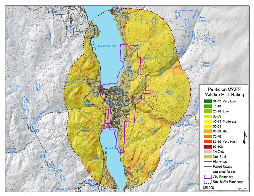
List of Recommendations
1.   Promote wildfire risk reduced development through the use of Wildfire Development Permit Areas
     and bylaws, covenants or other governing policies.

2.   Engage in public awareness of the wildfire risk throughout the community in the lead up, and during,
     the fire season.

3.   Consider guidelines that mirror those within the Wildfire Act and Regulations with regards to
     constructions activities within 300m of natural fuel sources (grass or forest) during Danger Class 4
     and 5.

4.   Ensure the local fire department has the appropriate equipment (transportation, water delivery, etc)
     and personal protective gear to undertake interface wildfire suppression.

5.   Pursue provincial funding to develop fuel management prescriptions and implement these
     prescriptions for the interface priority treatment list and proposed landscape level fuel breaks.

6.   Work with adjacent government agencies and local licensees to create landscape level fuel breaks to
     protect the community for an approaching large scale wildfire on the outskirts of the District.

7.   Using the supplied Implementation Plan, schedule and budget to proceed with a multi-year program
     to reduce the wildfire risk to the community through fuel management.

8.   Submit applications to the UBCM FireSmart Grant program for the recommended neighbourhoods
     (Hisula Highlands, Spiller Rd, Evergreen Drive and Ridgedale Ave) to help FireSmart these
     neighbourhoods.

                                                                                                         2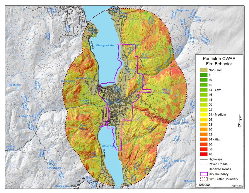
Table of Contents

List of Recommendations.............................................................................................................................. 2

Introduction................................................................................................................................................... 8

       CWPP Goals and Objectives..................................................................................................................9

Community Information and Background................................................................................................... 10

       Community Description.......................................................................................................................10

       Past Wildfire Threat Reduction Projects..............................................................................................11

       General Description of Forested areas................................................................................................. 11

       Community Water Supply................................................................................................................... 11

       Locations of Critical Infrastructure......................................................................................................12

Forest, Fuel & Past Wildfire Information..................................................................................................... 12

       Biogeoclimatic Information................................................................................................................. 12

       Typical Local Wildfire Impacts........................................................................................................... 13

       Harvesting Land Base.......................................................................................................................... 13

       Important Forest Health Issues............................................................................................................ 13

       Local Fire Weather............................................................................................................................... 14

Local Issues, Values and Support................................................................................................................. 16

       Resource Issues and Operational Constraints...................................................................................... 16

       Cultural Heritage Values Overview..................................................................................................... 17

       Community Support............................................................................................................................. 17

       Key Contacts, Partnerships and Funding Opportunities...................................................................... 17

Wildfire Fundamentals.................................................................................................................................18

       Wildfire Types..................................................................................................................................... 19

Existing Plans and Bylaws.............................................................................................................................19

                                                                                                                                                               3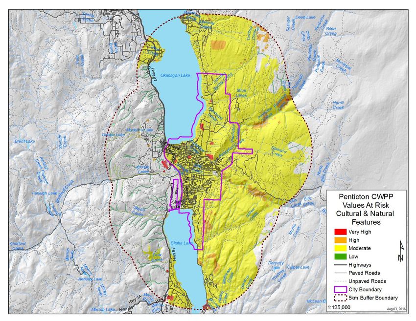
Provincial, District & Park Fire Management Plans............................................................................19

       Resource District Higher Level Plans.................................................................................................. 20

       Relevant Legislation, Plans, Bylaws & Policies.................................................................................. 21

Wildfire Risk Analysis.................................................................................................................................23

       GIS Methodology.................................................................................................................................23

       Fuel Types............................................................................................................................................23

       Fire History.......................................................................................................................................... 24

       Values at Risk...................................................................................................................................... 25

       Risk of Ignition.................................................................................................................................... 28

       Suppression Constraints.......................................................................................................................29

       Potential Fire Behaviour...................................................................................................................... 31

       Final Wildfire Risk Rating................................................................................................................... 33

       Interface Fuel Hazard Assessments..................................................................................................... 34

       Landscape Level Fuel Breaks.............................................................................................................. 36

Implementation Plan.................................................................................................................................... 38

Potential Funding Sources and Partners.......................................................................................................38

Conclusion................................................................................................................................................... 39

Appendix A - Wildfire Risk Analysis Methodology................................................................................... 40

       Component #1 - Fire Behaviour...........................................................................................................40

               Fuel Types....................................................................................................................................40

               Weather........................................................................................................................................ 41

               Topography.................................................................................................................................. 41

               Fire Intensity................................................................................................................................ 41

               Rate of Spread.............................................................................................................................. 41

                                                                                                                                                               4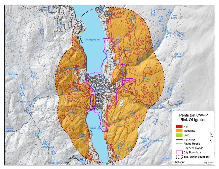
Crown Fraction Burned................................................................................................................41

     Component #2 – Risk of Ignition.........................................................................................................42

     Component #3 - Values at Risk - Structures........................................................................................44

     Component #4 – Suppression Constraints........................................................................................... 44

            Proximity to Roads – Access....................................................................................................... 44

            Proximity to Water Sources......................................................................................................... 44

            Steepness of Terrain.....................................................................................................................45

     Final Wildfire Risk Rating................................................................................................................... 46

Appendix B - FireSmart Development Recommendations..........................................................................47

     FireSmart Priority Zones......................................................................................................................47

     Buildings and Construction..................................................................................................................48

            Roofs............................................................................................................................................ 49

            Chimneys..................................................................................................................................... 49

            Exterior Building Cover...............................................................................................................49

            Windows and Door Glazing, Eaves, Vents and Openings...........................................................49

            Balcony, Decks and Porches........................................................................................................ 49

     Construction Guidelines.......................................................................................................................50

     Landscaping......................................................................................................................................... 50

     Utilities-Electric and Gas..................................................................................................................... 50

     Home Sprinkler Systems......................................................................................................................51

                                                                                                                                                              5
List of Figures

Figure 1 Average daily severity and danger ratings for the City of Penticton, 1970 - 2014. .................... 16

Figure 2 The fire triangle describes the three required components for wildland fire combustion............ 18

Figure 3 The wildland fire behaviour triangle depicted in the context of the fire triangle......................... 18

Figure 4 Proposed Wildfire Development Permit Area for the City of Penticton...................................... 22

Figure 5 Wildland fire history in the Penticton area, 1950s to 2010s.........................................................25

Figure 6 Structural values at risk in Penticton and vicinity........................................................................ 26

Figure 7 Cultural and environmental values at risk in Penticton and vicinity............................................ 27

Figure 8 Risk of ignition in and adjacent to Penticton................................................................................28

Figure 9 Wildfire suppression constraints in and around Penticton........................................................... 30

Figure 10 Potential wildland fire behaviour in Penticton area....................................................................32

Figure 11 Final wildfire risk rating for the City of Penticton and surrounding area.................................. 33

Figure 12 Wildland urban interface fuels treatment strategy for the City of Penticton..............................34

Figure 13 Possible landscape-level community fuel breaks for the City of Penticton............................... 37

Figure 14 The three priority zones as described in the FireSmart Manual................................................. 48

                                                                                                                                      6
List of Tables

Table 1 Summary of the biogeoclimatic zones within and adjacent to the City of Penticton.................... 13

Table 2 Average daily severity and danger ratings for Penticton, 1970 – 2014......................................... 15

Table 3 CFFDRS fuel types for the City of Penticton and adjacent areas..................................................24

Table 4 Assessment scores for priority wildland urban interface treatment areas......................................35

Table 5 Fire behaviour units and applied weighting...................................................................................42

Table 6 Risk of ignition units and applied weighting................................................................................. 43

Table 7 Values at risk units and applied weighting.................................................................................... 44

Table 8 Suppression constraints units and applied weighting.................................................................... 45

Table 9 Final wildfire risk weighting and risk class................................................................................... 46

                                                                                                                                        7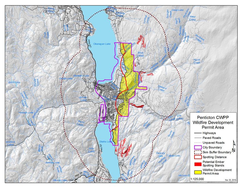
Introduction
The City of Penticton and the Okanagan valley in general, has long been familiar with the challenges
associated with living in a fire-prone environment. Major wildfire events such as the Garnet Fire in 1994
and the Okanagan Mountain Park Fire in 2003, as well as numerous other fires, have left their indelible
marks upon the landscape and this memory forces many residents to give pause during the hot, dry, and
windy days of summer in the Okanagan. Catastrophic wildfire incidents elsewhere in western North
America, including Slave Lake in 2011 and, most recently, Ft. McMurray in 2016, serve as reminders of
the challenges that communities can face in the wildland urban interface.

Wildfires are certainly not a new phenomenon in BC, or Canada given that they are a historical and
integral natural disturbance trend in our ecosystems. However, several natural resource management
policies have, over time, led to increases in both wildfire risk and behaviour. Policies and management
philosophies such as fire exclusion through aggressive suppression, as well as the virtual elimination of
traditional First Nations ecological burning has contributed to an increase in forest fuel loading in
ecosystems that had otherwise been fire-maintained. The interruption of periodic natural disturbance from
wildfire, coupled with the effects of climate change, has had significant effect on certain ecosystems in
BC, including those within the Okanagan valley.

There has been a growing trend since the late 1990s, with more provincial traction in the last 15 years, to
analyze the risk of wildfire through risk and consequence mapping, which has become known as Wildfire
Risk Analysis. The value of this analysis is that it maps outs the potential wildfire behaviour of an area as
well as the consequences of a wildfire impact on values (natural or structural). The resultant mapping
products allow for risk to values to be reduced through appropriate management decisions based on the
analysis. This analysis and the associated management recommendations can be incorporated into a
Wildfire Risk Management Plan that allows for the land manager to take appropriate actions to reduce
wildfire risk over time. For communities, this analysis and management plan has taken the form of a
Community Wildfire Protection Plan (CWPP).

The City of Penticton completed its first CWPP in 2006. As fuel and community characteristics are not
static over time, during the course of the ensuing decade the factors related to wildfire in the wildland
urban interface (WUI) continued to change. As such, the original CWPP had become outdated and was no
longer going to enable effective wildfire mitigation planning over the coming years. Additionally, in order
to apply for fuel management funding through the Union of BC Municipalities (UBCM) Strategic

                                                                                                           8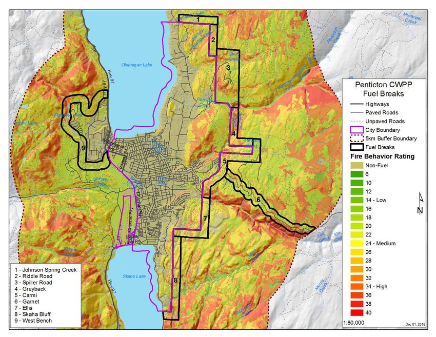
Wildfire Prevention Initiative (SWPI), the City was in need of an updated CWPP that conformed to
current SWPI criteria.
CWPP Goals and Objectives
The goal of the Penticton CWPP is to:
Strengthen and maintain Penticton’s resilience to wildfire.
This goal will be realized through achieving the following objectives:
Abate the fuel hazard within and adjacent to the wildland urban interface (WUI)
Reduce the ignition potential to future homes and developments through responsible
development
In order to achieve these objectives, the following strategies will be undertaken:
Analyse the wildfire risk to the City and recommend means to mitigate the risk
Assess and prioritize the interface fuel hazards for treatment
Review official City bylaws and policies for wildfire management opportunities
Access Partners in Protection FireSmart material and programs for educating the public on
home ignition hazards.
To ultimately achieve wildfire risk reduction to the infrastructure the following tactics will need to be
implemented (these are tasks described in this report but to be undertaken outside this report):
Secure funding (internal and external) for the development of fuel treatment prescriptions and
their implementation.
Discuss these treatments with adjacent land managing agencies where they exist and partner
with these agencies where possible.
Develop treatment prescriptions for fuel management sites and for landscape level fuel breaks.
Apply for a cutting permit to implement these prescriptions for crown land.
Tender out the work to qualified contractors.
Implement and monitor operations.
Pursue FireSmart grant funding from the UBCM to educate private land owners on wildfire risk
mitigation on their property.
9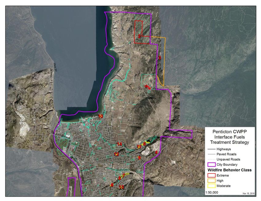
Community Information and Background
Currently, there is no publicly available fire management plan for the Okanagan-Shuswap Resource
District. There are, however, sections of the Okanagan-Shuswap Land and Resource Management Plan
(LRMP) that address fire on Crown land, in the context of integrated resource management across the
land base. Community wildfire management is also currently addressed in adjacent CWPPs for the
Regional District of Okanagan-Similkameen (RDOS) in 2008 and the Penticton Indian Band in 2009.

Community Description
Penticton (’the City’)is an incorporated city governed by an elected mayor and six councilors and
operates according to the requirements set out in the Local Government Act. The City is located between
the south end of Okanagan Lake and the north end of Skaha Lake, and is approximately half way between
the US border to the south and Kelowna to the north. Much of the City’s western boundary is bordered
by the Penticton Indian Band (PIB) reserve while the eastern boundary is adjacent to forested crown land
and small RDOS governed neighbourhoods. Nearby towns include Summerland 18km to the north and
Oliver 40 km to the south.
The City has a current year round population of approximately 32,300 people, with a municipal boundary
encompasses an area totaling 4,600 ha. In accordance with the City of Penticton’s CWPP adding a 2 km
buffer zone to the around the city limit adds another 9450 hectares, totaling 14,050 hectares. Currently,
the City reports having a total of 12,850 dwelling structures within its City limits. The number of
structures within the 2 km buffer zone are not known, however there are several existing housing
developments within the buffer zone.

The Penticton Indian Band (PIB) has a significant reserve area to the west of the City (Penticton 1 I.R.)
and is a prominent neighbour and stakeholder on adjacent lands. PIB holds interests in other land holdings
outside the City as well as several businesses in a variety of sectors adjacent to the City.     PIB is an
important stakeholder to be consulted during future fuel management projects.

Penticton has a strong connection to the forest and grasslands in the surrounding area. These natural areas
are used extensively for numerous recreational pursuits, including cycling, motorized off-road riding,
horseback riding, and hiking.. Tourism is an extremely important sector of the local economy, in part due
to the natural setting and landscape, as well as unique attractions, including extensive vineyards, orchards
and other agricultural land use.

                                                                                                         10
Past Wildfire Threat Reduction Projects
There have been several fuel management projects undertaken within and in proximity to the City. The
BC Wildfire Service, Penticton Fire Zone has completed several small scale fuels management projects
within the City over the last decade. Similarly, since 2009, the RDOS has undertaken fuels management
projects in proximity to the City, including projects in Arawana, Heritage Hills and Naramata.
General Description of Forested areas
Forest stands within the Penticton municipal boundary consist primarily of deciduous stands dominated
by Black Cottonwood (Populus trichocarpa) with pockets of Ponderosa Pine (Pinus ponderosa) and
Douglas-fir (Pseudotsuga menziesii). The deciduous stands are generally located within riparian areas
(creeks and lake shores), while the coniferous stands tend to occupy drier sites such as hillsides and
ridgelines, but can also be found adjacent to riparian areas on the valley bottom. In addition to forests, the
area adjacent to the City is also occupied by grassland communities and open forest types with grass
complexes beneath the canopy. Outside the City limits, but within the 2 km buffer zone, Ponderosa Pine
(Pinus ponderosa) is the most dominant species followed by Douglas-fir (Pseudotsuga menziesii). The
surrounding conifer stands vary from densely spaced to generally open canopies.
Community Water Supply
The City is situated between Okanagan Lake to the north and Skaha Lake to the south. There is a
constructed channel flowing from north to south that connects the two lakes on the western edge of the
City. These water bodies are incredibly important to the City’s tourism industry as they are the basis for
popular water-based recreation, and play a critical role in the City’s economy.
The city of Penticton relies on two water sources for their domestic and irrigation water supply. The first
being Penticton Creek and the second source is Okanagan Lake. The water treatment plant for the city has
a capacity of 88,000,000 L/day. There are a further 245 domestic water licenses and 243 Irrigation
licenses within the City of Penticton and surrounding area. Many of these water licenses are on either the
creeks which feed the valley bottom or on Okanagan or Skaha Lakes. The most highly allocated creeks
within the study area include Shingle Creek, Ellis Creek, Strutt Creek and Penticton Creek.
11Locations of Critical Infrastructure
There are several critical infrastructure features in and adjacent to the City. The City’s sewage treatment
plant is located near the aforementioned channel linking the two lakes. The sewage plant is located well
within the City and is not in the WUI. The fresh water treatment plant for both domestic and irrigation
water for the city, as well as the Penticton Regional Hospital, are located close to the downtown and is
located well within the City and not in the WUI.
On the eastern boundary of the City, above the industrial park, there is a hydroelectric substation located
within the WUI. This structure is surrounded by grassland and some forested stands.
The City landfill is located along the northern boundary of the City. It, too, is surrounded by grassland
and dense forest stands. The landfill has a well-established organic recycling program that results in an
accumulation of woody biomass piled up waiting to be ground up and recycled or already processed and
piled and awaiting removal. This material is a critical risk feature of the landfill for a fire either spreading
into the material in the landfill, or a fire originating in this material and moving out onto the landscape.
The City has a regional airport located at the south end of the City and adjacent to Skaha Lake. The
airport is surrounded by roads and developments and contains an extensive grassland area that is mowed
regularly. However, it is certainly within spotting distance of the WUI.
Forest, Fuel & Past Wildfire Information
Biogeoclimatic Information
The City falls primarily within the Ponderosa Pine biogeoclimatic ecosystem classification (BEC) zone
and transitions to the Interior Douglas-fir zone as elevation increases from the lower valley slopes. The
following table (Table 1) summarizes the total area for each BEC zone within the City and within the 2km
interface of the City.
12Table 1 Summary of the biogeoclimatic zones within and adjacent to the City of Penticton.
Community Area 2 km Buffer Area Com + 2km Buffer
(ha) (ha) (ha)
Penticton 4,600.3 9,448.6 14,048.9
Biogeoclimatic Zone
Interior Douglas-Fir (IDF) 9.2 2,188.0 2,197.3
Bunch Grass (BG) 158.7 765.9 924.7
Ponderosa Pine (PP) 4432.3 6494.7 1,0927.0
Typical Local Wildfire Impacts
Penticton has experienced the impact from several large scale wildfires in the past including the Garnet
fire in 1994 and the Okanagan Park fire in 2003. The Garnet fire resulted in the following outcomes:
Destruction of 18 homes and numerous other structures
5,500 ha of total burned area
Forced the evacuation of over 3,500 residents
Additionally, there have been several smaller fires within and adjacent to the City over the years. Given
the fuel types that exist in and around the City of Penticton, and the amount of development within the
WUI, the potential consequences of an interface fire have proven to be, and remain, significant.Timber
Harvesting Land Base
The area within the 2km interface area of the City is not a contributor to the timber harvesting land base
(THLB). The THLB starts further up the eastern slopes and also to the West towards Apex Mountain
Resort. As such, there are minimal impacts to timber supply with regards to wildfire or fuels management
treatments within the Penticton WUI.
Important Forest Health Issues
In the Okanagan Timber Supply Area (TSA) the mountain pine beetle epidemic peaked in 2008 and
subsequently declined steadily since that time. The most recent 2014 Forest Health Strategy for the
Okanagan TSA indicates substantial high hazard green Lodgepole Pine stands remaining in the Penticton
13beetle management unit (BMU), however it is important to note that these stands are located some
distance from Penticton, on the THLB.
No notable forest pathogen outbreaks are known to be occurring within the Penticton WUI. Future fuels
management prescriptions must consider the current and projected incidence of forest pathogens in and
around the City so as not to cause, aggravate or otherwise contribute to a forest health problem.
Local Fire Weather
In order to evaluate the daily forest fire hazard, the Canadian Forest Service developed the Canadian
Forest Fire Danger Rating System (CFFDRS). The CFFDRS consists of two main parts: the Canadian
Forest Fire Weather Index system (FWI) and the Canadian Forest Fire Behaviour Prediction System
(FBP).
Fire weather data for Penticton is available going back to the 1970’s. Looking at this data we find that, as
expected, the summer months have the highest average danger rating with August showing the highest
average Daily Severity Rating (DSR) and Overall Danger Rating at 11.3 and 3.3 respectively. Generally,
the City is considered to be at a moderate risk to wildfires, however when including the 2 km buffer zone
this risk increases significantly. The Initial Spread Index (ISI) is much higher in areas with increased
slope and available fuel.
14Table 2 Average daily severity and danger ratings for Penticton, 1970 – 2014.
Average Monthly Danger Rating for Penticton (1970-2014)
Month Average Daily Severity Rating Average Overall Danger Rating (1-5)
January 0.1 1.2
February 0.2 1.2
March 0.6 1.4
April 2.0 1.8
May 3.9 2.2
June 5.6 2.4
July 10.6 3.1
August 11.3 3.3
September 6.1 2.8
October 2.1 2.2
November 0.3 1.4
December 0.1 1.2
15Figure 1 Average daily severity and danger ratings for the City of Penticton, 1970 - 2014.
Local Issues, Values and Support
Resource Issues and Operational Constraints
When wildfires are large enough they can pose a significant threat to local resources and resource
infrastructure and compromise integral parts of local economies and resources that have an intrinsic value.
As listed in the Okanagan-Shuswap Land and Resource Management plan, some of the economic
resources that should be considered with respect to wildfire protection in the Penticton area include: the
infrastructure for renewable and non-renewable energy resources such as natural gas transmission lines,
and electrical lines. Local fish and aquatic/wetland habitat as well as terrestrial animals, plant-soil systems,
agricultural activities such vineyards, orchards and range land for both wildlife and domestic livestock.
Recreational sites used for skiing, mountain biking, hiking, canoeing along with many other activities are
also an important asset to the City.
Operational constraints that will limit the ability to complete fuel management activities are, for the most
part, minimal within the City. Much of the City has been highly developed allowing for easy access and
management in most areas. Beyond the municipal boundary, but within the 2 km buffer zone, there are
more constraints to be considered. To the east of the City there are steep slopes with little road access to
16many areas as well as large sections of unmanaged private land. The cooperation of land owners and
neighboring local governments can both limit management practices in areas outside the city limits or be
viewed as an opportunity to partner with cooperators when applying for treatment funding.
Cultural Heritage Values Overview
Penticton like any other City has a history that is preserved through many heritage sites throughout the
area. Some of the key cultural artifacts include the S.S. Sicamous paddlewheeler, the Munson Property,
White Lodge, Riordan House, Keyes House, Warren House, Debeck Home, Erickson Building, KVR
Station, Post Office, McGregor House, St. Saviour’s Anglican Church and Ellis Chapel. Other features
within the City that hold significant value include the Penticton water front, cemeteries, the Kettle Valley
Railway, the Trans Canada Trail and several greenbelts throughout the city.
Community Support
Past fuel management projects have been carried out within the City and they have occurred with public
support. Adjacent residents have expressed concern with the risk of wildfire within parks and other
natural areas surround the City and it is anticipated that, with appropriate public information sessions
public support will be retained for future projects.
Key Contacts, Partnerships and Funding Opportunities
Reducing the risk of wildfires to a community requires the broad cooperation of stakeholders and partners.
Some of the community agencies that could be approached to share information or partner with on fuel
management projects include: the RDOS, Ministry of Forests, Lands and Natural Resource Operations
(MFLNRO), BC Transmission Corporation and Fortis, Ministry of Transportation and Infrastructure
(MoTI), the Penticton Indian Band and other area First Nations, forest licensees, private land owners, and
BC Parks.
Potential funding partnerships to support the ongoing efforts to limit the risk of wildfires to the City could
include; Ministry of Forest, land, Natural Resource Operations (FLNRO), BC Transmission Corporation,
Fortis, Ministry of Transportation (MoT), forest licensees, BC Parks and First Nations.
17Wildfire Fundamentals
In order for combustion (fire) to occur, three components are required: fuel, oxygen, and heat. These three
components form what is often referred to as the ‘fire triangle’ and is illustrated in the figure below.
OXYGEN + HEAT + FUEL = FIRE
Figure 2 The fire triangle describes the three required components for wildland fire combustion.
Since all three components are required for a fire to occur, it follows that the removal of one component
(side) of the triangle will result in the extinguishing of the fire. This is the basis of fire suppression and
fire prevention. Fuels management focuses on the fuel side of the fire triangle. By removing, converting
or modifying forest fuels, a manager can greatly reduce the risk of a wildfire, or modify fire behavior in
the occurrence of a wildfire. Similar to the fire triangle, fire behavior can be broken down into three
components: fuels, weather and topography. These three components form what is often referred to as the
‘fire behavior triangle’ and is illustrated in the figure below.
Figure 3 The wildland fire behaviour triangle depicted in the context of the fire triangle.
18Of these three components, managers can only alter the fuel component of the triangle. Fuels have several
attributes that contribute to fire behavior including: porosity, size, and quantity and fuel moisture. Fire
behavior increases as fuel bed porosity and fuel quantity increases, and fuel size and moisture decreases.
Therefore, managers are able to alter fire behavior by decreasing the quantity of fuel loading, increasing
the compactness of the fuel layer, and increasing fuel moisture.
Wildfire Types
There are three general types of fires: subsurface, surface, and crown. Subsurface fires burn beneath the
forest floor in the organic layer of a soil. Subsurface fires can require lengthy mop-up operations and can
re-emerge months later due to the embers being insulated and undetected below ground.
Surface fires are considered to occur within the area above the first two meters of the forest floor. Surface
fires, while being easier to suppress, produce soil heating and can result in the volatizing of soil nutrients.
The intense heating of the soil can also create hydrophobic layers that contribute to surface erosion.
Crown fires occupy the canopy layers of the stand. Crown fires are the most difficult and dangerous to
suppress. They have the highest intensity levels (energy output), the greatest immediate and long-term
ecological effects and pose the greatest threat to structures. Generally speaking, fuel hazard mitigation is
directed towards reducing the initiation and propagation of crown fire and reducing the intensity of
surface fires.
Existing Plans and Bylaws
Provincial, District & Park Fire Management Plans
In the context of wildfire management in British Columbia, fire management plans are documents that are
completed by a land manager (i.e. natural resource district manager, or provincial park manager) that
identify values on the landscape and guide fire management and response planning and operations.
District fire management plans are not a statutory requirement, although they are required through
Ministry policy. Currently, there is no publicly available fire management plan for the Okanagan
Shuswap Natural Resource District.
In 2012, the Forest Practices Board of BC completed a special investigation into fire management
planning and made several recommendations, including involving local governments and the public in the
19planning process where appropriate. To the extent that natural resource district and provincial park fire
management planning considers potential values at risk and other factors related to fire management and
response operations, the City should encourage the provincial government to include the City’s interests
in their fire management planning processes at the forest district and provincial park level. This is best
done through continual dialogue with these agencies.
Resource District Higher Level Plans
The Okanagan-Shuswap Land and Resource Management Plan (LRMP) contains multiple references to
wildfire, including the following:
Part 4 – Community/Crown Interface:
Section 7: “Protect populated areas from forest fire hazards in the wildland-urban interface,
and protect the provincial forest from fires originating on contiguous private land.”
Section 7.1: “Where practical, coordinate and implement fire hazard reduction activities
with priority areas for prescribed burning for ecosystem enhancement purposes.”
Part 4 – Ecosystem Management – NDT4 (open forests and grasslands):
Section 10.1: “Where practical, return fire to the NDT4a at historical fire cycle intervals by
developing and implementing a burn plan that includes restoration and maintenance
burning.”
Section 10.3: “Develop and implement a plan to modify suppression on naturally occurring
wildfires that meet impact prescriptions.”
Section 11.9: “Develop a fire management plan for the NDT4a and b.”
Section 11.11: “Develop and implement a plan to modify suppression on naturally
occurring wildfires that meet impact prescriptions.”
Part 4 – Wildlife – Mule Deer Winter Range:
Section 3.4: “Where practicable, utilize prescribed burns under specific conditions or
mechanical treatments to enhance winter range forage values.”
The broad intentions pertaining to wildfire and wildfire management as presented in the LRMP do not
directly conflict with the wildfire protection needs of the City. Actions that restore and manage historical
20fuels levels on adjacent Crown land will have the effect of enhancing the wildfire protection strategies
taken by the City.
Relevant Legislation, Plans, Bylaws & Policies
A review of the current local government documents was undertaken to determine if there was anything
that was not congruent with FireSmart guidelines or responsible development with regards to minimizing
wildfire risk.
Responsible development is undertaken through ensuring that future developers do not build homes or
neighbourhoods that will be at risk of ignition from a wildfire. This is best done by ensuring that a
wildfire management professional is involved early in the planning and permitting process. By assessing
the proposed development or construction plan, the wildfire professional is able to make
recommendations that will increase the survival of the development/home in the event of a wildfire.
This is typically accomplished, in general terms, by suggesting non-flammable building materials are
being used, landscaping is chosen such that it will not support combustion within close proximity of the
home and that the neighbourhood (for large scale developments) is designed in an appropriate manner to
minimize wildfire risk.
The resultant effect of these actions is that the home or development constructed will not ignite during an
ember shower, or from radiant heat, from an adjacent wildfire. If a home, or a whole development, will
not burn, then it effectively becomes a fuel break for the community (i.e. the wildfire might burn up to the
yard but not into it and beyond). Such homes act as a fuel break for the community and, since they will
not burn, are not burdens on fire suppression resources in the event of a wildfire. Additionally, by
preventing a fire from igniting a home, it also prevents that home from igniting an adjacent home through
radiant heat and so on throughout the neighbourhood.
There are many local governments in BC that have engaged in the process of responsible development
(e.g. North Vancouver, Maple Ridge, Lumby, Lake Country, etc.) as part of their development permit
process by establishing Wildfire Development Permit Areas (WDPAs) and/or associated bylaws that
govern development. The websites for these local governments contain their bylaws (for review) and,
where applicable, maps of the WDPAs.
A potential WDPA for the City have been recommended in the map below. It was derived by delineating
the potential spotting distance from high fire behavior stands (red polygons) within the 2km buffer zone
21(purple line outside the City boundary). This potential spotting distance is illustrated by the red line
within the City boundary. This spotting distance line was then modified to follow the closest roadway or
other logical feature where possible. This WDPA is just a suggested location and further modification
may be desired by City staff, including the emergency manager and fire chief.
Figure 4 Proposed Wildfire Development Permit Area for the City of Penticton.
It is recommended that the City give consideration to establishing bylaws, similar to those of the
aforementioned local governments, to guide future development within the suggested WDPA. Such
development would need to adhere to either FireSmart guidelines or those guidelines in the National Fire
Protection Association documents NFPA 1141 and 1144 (with the latter being more detailed and robust).
This process would involve requiring a qualified professional to assess the wildfire risk using the
assessment procedure chosen by the City (NFPA or FireSmart) and, if warranted, to provide a report of
recommendations, signed and sealed by a wildfire professional, that indicate how the development can be
undertaken to minimize wildfire risk. Through time, the overall effect will be the building of homes and
developments that are resilient to wildfire. This will greatly benefit the community in the long term.
22Wildfire Risk Analysis
GIS Methodology
The GIS methodology that was used has been included in Appendix A. Please refer to it for an
explanation of how the maps in this section were created.
Fuel Types
The Canadian Forest Fire Danger Rating System was developed as a means to provide fire managers with
fire intelligence in order for them to make appropriate management decisions. The system consists of two
separate parts: The Canadian Forest Fire Weather Index (FWI) and the Canadian Fire Behaviour Predictor
System (FBP).
Part of FBP system is the prediction of fire behaviour for forest fuel types. Different fuel types have
varying fire susceptibility and volatility and, therefore, different potential fire behavior under varying
environmental conditions. The C2, C3, C4 and, sometimes C7, fuel types generally express the highest
intensity fire behaviour of the forested fuel types, particularly with regards to crown fires, under extreme
weather conditions. The slash (S) and grassland (O) fuel types have varying degrees of fire behaviour
depending on a number of site attributes that include those drivers that affect availability of fuel for
combustion (described later in this report).
The table below summarizes the fuel types for the area within the City boundary and within the 2km
buffer zone around the City.
23Table 3 CFFDRS fuel types for the City of Penticton and adjacent areas.
Community Area 2 km Buffer Area Com + 2km Buffer
(ha) (ha) (ha)
4,600.3 9,448.6 1,4048.9
Fuel Type
Ponderosa Pine-Douglas-Fir (C7) 892.4 2,874.0 3,766.4
Standing Grass (O-1b) 741.4 3,084.0 3,825.4
Leafless Aspen (D1) 28.6 87.4 115.9
Boreal mixedwood-green (M2) 50.3 176.6 226.9
Spruce-Lichen woodland (C3) 0.0 31.1 31.1
Non-fuel 2,491.4 619.9 3,111.3
Water (W) 402.5 2,575.6 2,978.1
The above data shows that a sizable area is covered by what could be referred to as ‘high risk’ fuel types
(C7 and 0-1b). These fuel types encompass an expansive and consistent area that can experience high fire
behaviour characterized by a high rate of spread. These fuel types can also be susceptible to ember
spotting during intense fires where wind events blow burning embers ahead of the fire to start new spot
fires. These spot fires grow and become part of the original wildfire, contributing to an increased fire size
or starting a separate large fire that can threaten values or otherwise challenge suppression resources.
Fire History
Ecosystems within the Okanagan valley are characteristic of those that have evolved with the historical
disturbance of fire. Past wildfires in the Bunchgrass ecosystems would have been fast moving grass fires
that burnt out quickly. Fires on the previously open Ponderosa Pine and Douglas-fir forested slopes
would have burnt quickly through the understory/grass complex, killing off young trees that were not yet
fire resistant and maintained the slopes in an open forest conditions. At higher elevations to the east and
west of the City, stand initiating fires would have occurred that resulted in large scale fires.
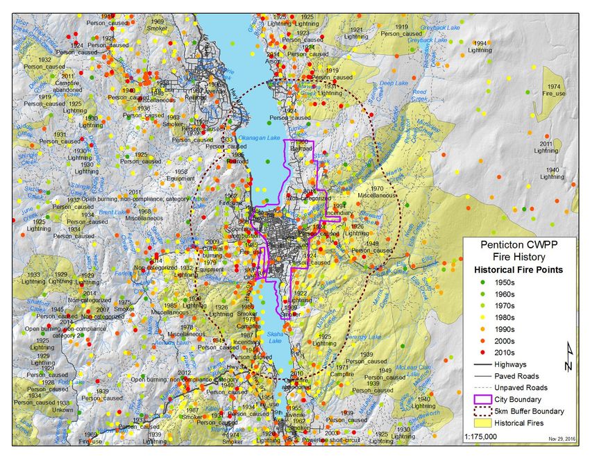
24The BC Wildfire Service (BCWS) records fire occurrence through time that allows fire history to be
tracked. Fire history data for the subject area was provided by the government and mapped. The image
below shows the past fire history for the City area; from small spot fires to large scale fires.
Figure 5 Wildland fire history in the Penticton area, 1950s to 2010s.
As shown on the map, fire starts have been frequent within 2km of the City and the adjacent area. The
Penticton Fire Department and the BCWS have a good chance, under most conditions, of suppressing
those starts within the valley bottom with the diligent reporting of such fires by the public followed by
aggressive and fast response. This map is a good public information tool for discussing wildfire risk with
the public and should be available to staff for doing so. It is also a dynamic map that can be updated
annually as needed.
Values at Risk
Risk is defined as the probability of an action occurring and the subsequent consequence of that action
when it occurs. With wildfires, consequence is often referred to as the loss of, or damage to, a value.
25These values can be natural (endangered species, wildlife habitat), cultural (First Nation values, heritage
values) or structural (human development).
Typically, with wildfire risk analysis, buffers will be applied to values to create zones around the value to
indicate the consequence of a wildfire occurring within that zone. This was done using 30m, 100m and
2km as per the GIS methodology in Appendix A.
The highest two zones (Very High and High) are adapted from the nationally recognized Partners in
Protection FireSmart program (Priority Zones 2 and 3) and the Low rating is derived from the
provincially accepted spotting distance for some fuel types under extreme weather conditions. That is to
say, with the right wind, fuel type and moisture conditions, a wildfire up to 2km away could potentially
spot embers onto the values, or adjacent fuels, possibly starting a fire adjacent to the value or igniting the
structure directly. The map below shows the structural values within the municipal boundaries with risk
zones around those structures.
Figure 6 Structural values at risk in Penticton and vicinity.
26The map provides an illustration of the location of the values at risk and, when overlaid with the fire
behaviour mapping, the risk (probability x consequence) of a wildfire occurring within proximity to the
values becomes apparent (discussed later in this report).
In addition to structural values, there are natural features within the 2km zone that could potentially suffer
consequences from a wildfire. These natural values would range include old growth management areas,
sensitive wildlife habitat, rare/endangered/vulnerable plant communities or known or past occurrences for
species at risk (both flora and fauna) and riparian areas. Depending on the critical nature of these values,
they are rated Low to Very High and are shown on the map below.
Figure 7 Cultural and environmental values at risk in Penticton and vicinity.
While the City will be most concerned with the protection of structures, the location of these sensitive
natural features will be important with regards to prescribing and implementing fuel management or
landscape level fuel breaks. The information may also be useful with regards to general community
planning and avoiding these sensitive locations or otherwise managing for them during development.
27Risk of Ignition
Wildfire ignition sources fall into two categories: Natural (lightning) or Human Caused (machinery,
people). Of these two sources, we can only reduce the chance of human caused ignitions through public
education.
While public education is a powerful tool to reduce ignition risk, it doesn’t have a 100% success rate and,
therefore, it is important to understand the likely location of potential human caused ignitions in order to
manage the risk of human ignition. This is accomplished by determining and mapping where human
activity occurs on the landscape. Additionally, certain fuel types are more susceptible to lightning than
other fuel types and the location of these fuel types can be mapped to predict potential risk of ignition
from lightning.
Figure 8 Risk of ignition in and adjacent to Penticton.
Public education is the best means to reducing the risk of ignition within the City. This can involve
posting seasonal signs at appropriate locations around the City to remind commuters, residents and
28tourists of the potential consequences of discarding cigarettes, starting fires, or engaging in other activities
that can start a wildfire. These signs should also include the emergency number for reporting a wildfire.
Public education can also involve developing guidelines for construction companies that engage in high
risk activities (as defined in the Wildfire Act). These guidelines would put restrictions on what activities
can be undertaken within 300m of grassland or forested ecosystems. This would be most critical in the
perimeter areas of the community and would only apply to those activities that could cause sparks or
otherwise start fires such as those documented in the Wildfire Regulations. Additionally, these
restrictions would only apply while the community is in Danger Class 4 or 5 and/or at the discretion of
the Fire Chief.
Suppression Constraints
Successful suppression of a wildfire is dependent on a number of factors including water availability, road
access and terrain characteristics, specifically steepness of slope. By using these three conditions we can
map potential areas within the City where constraints to suppression tactics could be experienced. Such
areas are shown in the map depicted in figure 9.
29Figure 9 Wildfire suppression constraints in and around Penticton.
The suppression constraints analysis indicates that the City has Low to Moderate suppression constraints
within the municipal boundaries. Of note is that there are several areas within the 5km buffer surrounding
the municipal boundary that indicate High suppression constraints. These areas are generally
characterized as lacking access roads. The use of local helicopters and air tankers can be useful in
slowing down fires in poor access areas, but aircraft do not put out wildfires and, eventually, crews and
water will need to be brought on site to such fires to ensure they are out.
The only condition that can readily be addressed with suppression constraints is access to those areas
where none, or only poor access exists. This can be done by improving existing trails or old roads to be
more accessible to emergency vehicles but this can be a costly endeavor and, given that these poor access
areas are beyond the municipal boundary, it’s not an action the City can undertake. Another means to
improving access to fire in poor access areas is by ensuring the local fire department has appropriate
equipment to utilize trails, narrow roads or old roads in disrepair.
30There are several models of skid units that can be attached to small 4 x 4 trucks or towed behind ATVs
that allow fire departments to get water and tools to, or closer to, remote wildfires where access is too
poor for their standard vehicles. Being able to transport water to a remote fire while longer, more time
consuming hose lays are being set up helps contribute to the aggressive action required to engage in
proper initial attack.
In addition to suppression equipment, maintaining appropriate personal protective equipment (PPE) for
firefighters who will be engaged in wildland firefighting is extremely important for protecting the health
and safety of first responders. Providing firefighters with high-quality PPE will help them perform at their
best, and if this means being able to move on foot through wildland fuels with greater speed and comfort,
that may have a direct relationship to achieving a successful suppression outcome in the event of a
wildland fire incident.
Potential Fire Behaviour
The potential fire behaviour in and around the community is depicted below in figure 10.
31Figure 10 Potential wildland fire behaviour in Penticton area.
The potential fire behaviour analysis indicates that most of the increased fire behaviour potential is slope-
influenced. In general terms, these higher fire behaviour areas are not located immediately adjacent to
homes. The threat these high fire behaviour areas pose to the community is that they can contribute to an
ember shower during a wildfire.
Where land ownership allows, the City should consider engaging in fuel management in these high fire
behaviour interface areas. For example, lowering the potential fire behaviour on Campbell Mountain
would have a limiting effect on fire brand (i.e. embers and larger airborne burning particles) production
originating on Campbell Mountain and impacting adjacent structures.
While much of the high fire behaviour area exists outside the immediate City interface, the City can still
work to lower the risk of these areas to the City through the strategic location of landscape level fuel
breaks as addressed later in this report.
32Final Wildfire Risk Rating
The Final Wildfire Risk Rating is a composite of the sub component layers of Value at Risk (natural and
structural), Risk of Ignition, Suppression Constraints and Potential Fire Behavior. The layers are
combined according to the weightings and procedure listed in Appendix A. The map below shows the
Final Wildfire Risk Rating results.
Figure 11 Final wildfire risk rating for the City of Penticton and surrounding area.
Much of the City tends towards the moderate or lower end for Wildfire Risk Rating. This is primarily due
to the structural values being concentrated and in the valley bottom where suppression constraints, fire
behaviour and risk of ignition are low. The high Wildfire Risk areas are restricted to the steep, upper
slopes where access is very poor and/or fire behaviour is high.
By implementing the recommendations within the sub component sections (layers), the City will be able
to either reduce the rating or otherwise manage these high risk locations.
33Interface Fuel Hazard Assessments
Since 2008, interface fuel hazard assessments have been conducted using the provincial standard
system, ’Wildland Urban Interface Threat Assessments in BC’ (Morrow, Johnston, Davies). The system
is designed to quantify fuels within the interface and to produce a threat class rating for the site. This
numerical threat rating can then be used to prioritize interface areas for treatment according to their actual
fuel hazard on site and the threat it poses to adjacent values.
Areas to be assessed within the City were determined by overlaying the Values at Risk (structures) map
with the Potential Fire Behaviour Map. Where the 100m buffer around values intersected with a potential
fire behaviour of moderate or greater a 100m polygon was buffered off the values.
Figure 12 Wildland urban interface fuels treatment strategy for the City of Penticton.
34You can also read